The Western Hemisphere
|
|
|
- Russell Ralf Wilkerson
- 6 years ago
- Views:
Transcription
1 The Western Hemisphere North America, Central America, South America and the Caribbean GEOGRAPHY BEE STUDY GUIDE Fall 2017 North Chevy Chase Elementary School Name Homeroom Teacher
2 TABLE OF CONTENTS North America 3 United States 4 Reference Map 5 Did You Know? 6 Elevation Map 7 Major Mountains 8 Major Rivers and Lakes 9 The States: Alabama to Wyoming 11 Canada 62 Reference Map 63 Mexico 79 Reference Map 80 Caribbean 83 Reference Map 84 Central America 93 Reference Map 94 Countries at a Glance 97 South America 103 Reference Map 107 Map of Capitals 109 Countries at a Glance 112 2

3 NORTH AMERICA 1. What ocean lies to the east of North America? 2. What ocean lies to the west of North America? 3. What ocean lies to the north of North America? 4. What is the name of the gulf off eastern Mexico and southeastern North America? 5. What is the name of the sea north of western Canada? 6. If you were to walk south from the western United States, what country would you enter? 7. What is the name of the huge bay in northeastern Canada? 8. If you were to travel from Canada to Mexico, in which direction would you travel: north, south, east, or west? 9. What country in Asia is off the northwestern coast of North America? 10. What is the name of the group of lakes between Canada and the United States? 3

4 The United States of America Mt. Rushmore, South Dakota 4

5 MAP OF THE UNITED STATES X 5
6 DID YOU KNOW? The United States of America is the third largest country in the world in area and it is the third largest in terms of population. Capital: Washington, D.C. First state: Delaware (December 7, 1787) Most recent state: Hawaii (August 21, 1959) Most populous state: California: approximately 39.5 million (2017) Least populous state: Wyoming: approximately 590,000 (2017) Biggest city: New York City: 8.5 million people (2016) U.S. GEOGRAPHY EXTREMES: Biggest state in area: Smallest state in area: State farthest north: State farthest south: State farthest east: State farthest west: Contiguous geographic center: Geographic center (entire): Highest point: Lowest point: Longest river: Alaska: 656,425 sq. miles Rhode Island: 1,545 sq. miles Alaska Hawaii Maine (Note: some of Alaska s Aleutian Islands cross the 180-degree longitude line, and are technically farther east than the other U.S. states). Alaska Smith County, Kansas South Dakota Mount McKinley, Alaska: 20,300 ft. (6194 m) above sea level Death Valley, California: 282 ft. (86 m) below sea level, the lowest point in the Western Hemisphere Missouri River: 2,540 miles (4090 km) River with greatest volume of water: Mississippi River: 2,348 miles (3778 km) Biggest lake: Lake Superior: 31,820 sq. miles (82414 sq. km) Biggest island: Hawaii: 4,038 sq. miles (10459 sq. km) Tallest waterfall: Ribbon Falls in California: 1,612 feet (491 m) Waterfall with the greatest volume: Niagara Falls, New York U.S. WEATHER EXTREMES: Coldest city: Snowiest city: International Falls, Minnesota, with a mean temperature of 36.4 Fahrenheit (F). Blue Canyon, California, with an annual average inches of snow. Hottest temperature: California 134 F. at Greenland Ranch on July 10, 1913 Coldest temperature: Alaska: -80 F. at Prospect Creek on January 23, 1971 Most snow in 24 hours: Colorado: 76 inches (192.5 cm) fell in one day at Silver Lake, Colorado Most rain per year: Hawaii: 460 inches (1168 cm) fall on Mt. Waialeale, Kauai, each year Strongest wind: Mt. Washington, New Hampshire, with recorded gusts of 231 mph (372 kph) 6

7 UNITED STATES MAP OF ELEVATION 7
8 MAJOR MOUNTAINS OF THE UNITED STATES Use the Reference Map on page 6 and the Elevation Map on page 8 to answer the following questions. 1. The Rocky Mountains are the largest mountain range in the United States. The Rockies begin in Canada, and continue south to the border with Mexico. In which six states can you find the Rocky Mountains?,,,,, and. 2. The Appalachian Mountains, a long mountain range found in the eastern United States, features a favorite trail for hikers from all over the world. The trail winds 2,178 miles (3505 km) from Springer Mountain, Georgia to Mt. Katahdin, Maine. List three of the 17 states that the mountain range passes through.,, and 3. At 14,505 ft. (4421 m), Mt. Whitney is the highest mountain in the contiguous United States (the lower 48 ) and is part of the Sierra Nevada Mountain Range. In what two states would you find the Sierra Nevada mountain range? and 4. In 1980, the volcano Mt. St. Helen erupted. It is part of the Cascade Mountain Range. In what three states will you find this mountain range?,, and 8

9 MAJOR RIVERS OF THE UNITED STATES Use the Reference Map on page 6 and the map below when answering these questions. 1. From , explorers Meriweather Lewis and William Clark paddled up the Missouri River looking for a waterway to the west coast of the United States. The Missouri River starts in Montana (see the X on the map on page 6) and flows through or touches seven states before flowing into the Mississippi River at St. Louis, Missouri. Use a highlighter to trace the path of the Missouri from the star in Montana where it joins the Mississippi River. Name the seven states it flows through or touches.,,,,,, and. 2. The Colorado River flows through or touches five states on its way to the Pacific Ocean. Along the way, it forms the famous Grand Canyon in Arizona. Name the five states.,,,, and. 3. A major river forms the boundary between the state of Texas and its southern neighbor, Mexico. Name the river.. 4. What river forms the border between Washington and Oregon?. 5. What river forms the southern borders of Illinois, Indiana and Ohio?. 9

10 Fill in the names of the Great Lakes. There is an easy way to remember the lakes names: Remember: HOMES H uron O ntario M ichigan E rie S uperior Did you know? Lake Superior is the largest fresh water lake in the world? Lake Huron is the third largest, and Lake Michigan is the fourth largest. Lake Superior is one of the deepest lakes in the world. The average depth of the lake is 483 ft. (147 m). At its deepest, the lake is 1,332 ft. (406 m). You could fit two Washington Monuments into the lake without reaching the surface! Four of the Great Lakes form part of the natural border between the United States and Canada. Only Lake Michigan lies entirely in the United States. 10
11 1. What is the capital of Alabama? 2. Color in blue the body of water that forms part of the southern border of Alabama. What is it called? 3. What is the name of the river that forms part of Alabama s eastern border? 4. Find the city east of Montgomery. In World War II, a famous squadron of African-American pilots trained there and took their name from that city. They were called the Airmen. 5. What state borders Alabama to the west? 6. What state borders Alabama to the east? 7. What state borders Alabama to the north? 8. What state borders Alabama to the south? 11
12 1. What is the capital city of Alaska? 2. What country borders Alaska on the east? 3. The Bering Strait (a narrow waterway connecting two large bodies of water) separates Alaska from another country. Name that country. 4. The mountain northwest of Anchorage is the tallest peak in North America. What is its name? 5. Which Alaskan city is farthest north? 6. The Iditarod dog sled race runs from Anchorage to a city on the southern coast of the Seward Peninsula (land nearly surrounded by water). What is the name of this city? 7. What ocean borders Alaska on the north? 8. What ocean borders Alaska on the south? 9. What is the name of the river that flows from Canada, across Alaska, and into the Bering Sea? 10. What is the name of the mountain range that runs across northern Alaska? 12
13 1. What is the capital of Arizona? 2. What country borders Arizona on the south? 3. What state borders Arizona on the north? 4. The Colorado River eroded rock to form the world s large gorge (canyon). It is protected in a national park called 5. What two states border Arizona on the west? and 6. You can be in four states at once if you go to the northeastern corner of Arizona and get down on all fours. What are the other three states?, and 7. What river forms most of the western border of Arizona? 8. The national park in southeastern Arizona located east of Tucson is named after a large cactus plant. What is its name? 13
14 1. What is the capital city of Arkansas? 2. Trace in blue the river that forms most of the eastern border of Arkansas. Name the river. 3. A national park protects the thermal springs (hot water coming out of the ground) that gush from an Arkansas mountain. This park is called. Color it green. 4. What state makes up most of Arkansas western border? 5. What state borders Arkansas on the south? 6. What state borders Arkansas on the north? 7. What state borders Arkansas on the southwest? 8. What two states border Arkansas on the east? and 14

15 1. What is the capital of California? 2. What ocean borders California on the west? 3. Which country borders southern California? 4. The lowest and hottest point in the United States is a valley in southeastern California, which is 282 feet below sea level. Circle it in brown. Name this valley. 5. What state borders California on the north? 6. What two states border California on the east? and 7. The largest city in southern California is where many movies and television shows are made. What is the name of the city? 8. What is the name of the national park located east of San Francisco? 15
16 1. The capital city Colorado is known as the Mile High City because it is one mile above sea level. What is the name of this city? 2. Trace in blue the four large rivers in Colorado. Name these four rivers.,, and. 3. What two states border Colorado on the north? and 4. What two states border Colorado on the east? and 5. What state borders Colorado on the west? 6. The Four Corners, where four states intersect, is located at the southwest tip of Colorado. What are the three other states that touch Colorado at this point?, and 7. The national park located in southwest Colorado, just west of Durango, features ancient Native American dwellings. What is its name? 8. The Rocky Mountains go through Colorado. Name three mountain ranges in Colorado., and. 16
17 1. What is the capital of Connecticut? 2. Color in blue the sound (large body of water that connects larger bodies of water) that borders Connecticut on the south. What is this sound called? 3. This sound is part of which ocean? 4. The name Connecticut comes from an Indian word that means long tidal river. Trace in blue the river that runs through Hartford. Name the river. 5. What state borders Connecticut on the west? 6. What state borders Connecticut on the east? 7. What state borders Connecticut on the north? 17
18 1. What is the capital city of Delaware? 2. Delaware earned its nickname because it was the first of the original 13 colonies to ratify the Constitution. What is Delaware s nickname? 3. What state borders Delaware on the west and south? 4. What state borders Delaware on the north? 5. What state is across the water from Delaware on the northeast? 6. What bay (large body of water) borders Delaware on the northeast? 7. What is the name of the river that flows into the north end of this bay? 8. This bay is part of which ocean? 9. Delaware is the second smallest state in the United States. Using the map scale, estimate how wide (east to west) this state is at its widest point: 50 miles, 100 miles, 200 miles, or 300 miles? 18
19 1. What is the capital of Florida? 2. What ocean borders Florida on the east? 3. Which large body of water borders Florida on the west? 4. The world s largest marsh (soft, wet land) is a national park in southern Florida. The name of this park is 5. What two states border Florida on the north? and 6. What is the name of the series of islands off the coast of south Florida? 7. Name Florida s southernmost city. 8. The oldest city in the U.S. is on the northeastern coast of Florida. It was named for a saint. What is its name? 9. What is the name of the large lake in south central Florida? 19
20 1. Civil rights leader, Martin Luther King, Jr., was born in the capital of Georgia. What is the name of this city? 2. What ocean borders Georgia on the southeast? 3. What is the name of the swamp in southern Georgia, which extends into Florida? Color it in brown. 4. What state borders Georgia on the northeast? 5. What state borders Georgia on the south and west? 6. What state borders Georgia on the west? 7. What two states border Georgia on the north? and. 8. What is the name of the river that forms Georgia s eastern border? 20

21 1. What is the capital of Hawaii?. On which island is it located? 2. In which ocean is Hawaii located? 3. The Hawaiian Islands are the projecting tops of an undersea mountain range. Color each island a different color. 4. This island is the largest in the state of Hawaii and marks the southernmost point in the United States. What is the name of this island? 5. The city of Kaunakakai is on which island? 6. Which of the major islands is farthest west? 7. The highest point on Hawaii is a volcano at 13,796 feet. Circle it in purple. What is its name? 21
22 1. What is the capital of Idaho? 2. What country borders Idaho on the north? 3. Trace all the rivers in Idaho in blue. What is the name of the river that runs by Idaho Falls? 4. What two states border Idaho on the east? and 5. What two states border Idaho on the south? and 6. What is the name of the mountain range that runs along much of the eastern border of Idaho? 7. What two states border Idaho on the west? and 8. The tallest peak in Idaho is 12,662 feet. What is its name? 22
23 1. The capital of Illinois was Abraham Lincoln s home when he was elected president of the United States. He was buried there after his assassination in What is the capital? 2. Color in blue the Great Lake that borders Illinois. What is it called? 3. The third largest city of the United States is located on the shore of Lake Michigan. It is sometimes referred to as the Windy City. Name this city. 4. What great river forms the western border of Illinois? 5. What state borders Illinois on the north? 6. What two states border Illinois on the west? and 7. What two states border Illinois on the east? and 8. What river forms the southern border of Illinois? 9. What river runs diagonally through Illinois? 23
24 1. The capital of Indiana is famous for a 500-mile sports car race that is held there on Memorial Day weekend. What is its name? 2. Which of the Great Lakes forms part of the northern border of Indiana?. Color it blue. 3. Trace in blue the river that forms the southern border of Indiana. It is called the. 4. Which state borders Indiana to the north? 5. Which state forms most of Indiana s eastern border? 6. Which state borders Indiana to the south? 7. Which state borders Indiana to the west? 8. What is the name of the large city in northwestern Indiana that is on the shores of a Great Lake? 24
25 1. What is the capital city of Iowa? 2. Trace all the rivers of Iowa in blue. What is the name of the river that forms Iowa s eastern border? 3. What is the name of the river that forms most of Iowa s western border? 4. What two states border Iowa on the east? and 5. What state borders Iowa on the south? 6. What two states border Iowa on the west? and 7. What state borders Iowa on the north? 8. What is the name of the river that flows by Cedar Rapids? 9. What is the name of the river that flows by Ottumwa? 25
26 1. What is the capital of Kansas? 2. What river forms the northeastern border of Kansas? 3. What city in Kansas is located where the Kansas River flows into the Missouri River? Circle it in orange. There is also a larger city in Missouri, next to this city, that has the same name. Circle it in brown. 4. What state borders Kansas on the south? 5. What state borders Kansas on the east? 6. What state makes up most of Kansas s northern border? 7. What river runs through Wichita? 8. What state borders Kansas on the west? 9. What is the tallest peak in Kansas? 26
27 1. What is the capital of Kentucky? 2. What is the name of the river that forms Kentucky s northern border? 3. What state borders Kentucky on the south? 4. What state borders Kentucky on the southeast? 5. What two states border Kentucky on the northeast? and 6. What two states border Kentucky on the northwest? and 7. What is the name of the river that forms Kentucky s border with Missouri? 8. What national park is located in Kentucky? 9. The famous horse race, the Kentucky Derby, is held every spring in the city west of Frankfort, on the Ohio River. What is the name of that city? 27
28 1. The name of Louisiana s capital means red stick in French, because a French explorer found a pole marked with animal blood at this site. Name the city. 2. Color in blue the large body of water that borders Louisiana on the south. It is called the 3. This large city on the Mississippi River in southeastern Louisiana was protected from flooding by levees (dikes) that held back water, and canals that carried it away. In 2005, Hurricane Katrina devastated the levee system and flooded the city. Name this city. 4. What state borders Louisiana on the north? 5. What state borders Louisiana on the east? 6. What state borders Louisiana on the west? 7. Name the large river that forms part of Louisiana s eastern border and flows south through southeastern Louisiana? 8. What is the name of the large lake in southeastern Louisiana? 28
29 1. What is the capital of Maine? 2. What country borders Maine on the north, east, and west? 3. What ocean borders Maine on the southeast? 4. The tallest mountain in Maine is the northern endpoint of the Appalachian Trail, a hiking trail that runs from Georgia to Maine. Name this mountain. 5. What U.S. state borders Maine on the west? 6. The large lake in central Maine is shaped a little like a moose head. Name the lake. 7. What river flows through Bangor? 8. What Canadian province borders Maine on the northwest? 29
30 1. The oldest capitol building in use in the United States is located in Maryland s capital. Name the city. 2. What state borders Maryland on the north? 3. What two states border Maryland on the south? and 4. What state borders Maryland on the east? 5. A large body of water cuts deeply into Maryland, dividing the state into the flat Eastern Shore and the hilly Western Shore. Color it blue. What is it called? 6. Trace in blue the large river that flows from West Virginia into the western part of the bay. It is called the 7. What is the name of the river that flows from Pennsylvania into the northern part of this bay? 8. The biggest city in Maryland is a major port (a city with a harbor where ships arrive and depart) in north-central Maryland. What is its name? 30
31 1. What is the capital of Massachusetts? 2. What ocean borders Massachusetts? 3. Color in brown the cape (a point of land jutting into the sea) in southeastern Massachusetts. What is it called? 4. During the Revolutionary War, on the night of April 18, 1775, Paul Revere rode northwest from Boston to warn the people of approaching British troops. To what town did he ride?. Draw a line following the route from Boston to this town. 5. What is the name of the historic city in Massachusetts that is famous for its witchcraft trials? It is located on the east coast between Boston and Gloucester. 6. What two states border Massachusetts on the north? and 7. What two states border Massachusetts on the south? and 8. What state borders Massachusetts on the west? 9. What is the name of the river that runs north-south through western Massachusetts? 31
32 1. What is the capital of Michigan? 2. Michigan is a state made up of two peninsulas (land almost entirely surrounded by water). What are the two parts of Michigan called? The and the. 3. Which of the Great Lakes separates these two peninsulas of Michigan? 4. Which of the Great Lakes forms the northern border of the Upper Peninsula of Michigan? 5. What country lies north of Michigan? 6. A large city in southeastern Michigan near Lake Erie has been the site for car manufacturing for many years. What is this city? 7. What Canadian province borders the Lower Peninsula of Michigan to the east? 8. Which two U.S. states lie south of the Lower Peninsula? and 32
33 1. What is the capital of Minnesota? 2. Which country borders Minnesota to the north? 3. Which of the Great Lakes forms part of the northeastern border of Minnesota? 4. Minnesota has more than 12,000 lakes, which were created by glaciers (large, moving masses of ice and snow) during the last Ice Age. One of these lakes, Lake Itasca, is the source of a major river in the U.S. Circle the lake in blue and trace the river. What is the name of this river? 5. St. Paul and the city next to it are called twin cities. What is the name of the other city? 6. What U.S. state borders Minnesota to the east? 7. What U.S. state borders Minnesota to the south? 8. What two U.S. states border Minnesota to the west? and 9. What is the name of the national park in northern Minnesota? It was named for French-Canadian canoemen-fur traders who were the first Europeans to live in this area? 33
34 1. What is the capital of Mississippi? 2. What large body of water borders Mississippi on the south?. Color it blue. 3. What is the name of the river that forms much of Mississippi s western border? Trace it in blue. 4. What two states border Mississippi on the west? and 5. What state borders Mississippi on the north? 6. What state borders Mississippi on the east? 7. What is the name of the river that flows through Jackson? 8. A major battle raged during the Civil War in this city located west of Jackson. Name this city. 34
35 1. Missouri s capital is named after our third president. What is its name? 2. What is the name of the city at the meeting place of the Missouri and Mississippi Rivers? The city is known as the Gateway to the West. 3. What state borders Missouri on the north? 4. What state borders Missouri on the south? 5. What three states border Missouri on the east?,, and 6. What three states border Missouri on the west?,, 7. Name the river that forms the northwestern border of Missouri and then flows west to east through the state? 8. What is the river that forms the eastern border of Missouri? Trace it in blue. 9. The Ozarks are the oldest mountains in the U.S. They have been worn down to rolling hills. In which part of Missouri are they located: north, south, east or west? 35
36 1. What is the capital of Montana? 2. What country borders Montana on the north? 3. What river meets the Yellowstone River near the Montana and North Dakota border? 4. What state borders Montana on the west? 5. What two states border Montana on the south? and 6. What two states border Montana on the east? and 7. Montana is the only state in the United States that has a triple divide, where water can flow into the Pacific, the Atlantic, or Hudson Bay. This divide is located in a national park in northwestern Montana. Name this park. 8. The tallest mountain in Montana measures 12,799 feet and is in the Absaroka Range. What is its name? 9. What two mountain ranges are situated south of Billings? and 36
37 1. What is the capital of Nebraska? 2. Trace in blue the river that forms the eastern border of Nebraska. It is called the. 3. What is the largest city in Nebraska? 4. What state borders Nebraska on the north? 5. What two states border Nebraska on the south? and 6. What two states border Nebraska on the west? and 7. What two states border Nebraska on the east? and 8. The name Nebraska comes from the Indian word that means flat water. The flat water they were referring to is the river that flows across central Nebraska from west to east. What is its name? 9. What Nebraska city is located where the North and South Platte Rivers meet? 10. What river runs west-east through the northern part of Nebraska? 37
38 1. What is the capital of Nevada? 2. What is the name of the dam on the Colorado River along the Arizona-Nevada border? Color in blue the lake formed by this dam. 3. The man-made lake formed by this dam is a reservoir (a natural or artificial lake in which water is stored for use). What is the name of this lake? 4. Circle in orange the large city in southeastern Nevada. What is its name? 5. What two states border Nevada on the east? and 6. What two states border Nevada on the north? and 7. What state borders Nevada on the south and west? 8. What is the name of the large lake on Nevada s southwest border? 9. What is the name of the national park in eastern Nevada? 38
39 1. What is the capital of New Hampshire? 2. Trace in blue the river that forms New Hampshire s western border. What is it called? 3. What state borders New Hampshire on the east? 4. What state borders New Hampshire on the south? 5. What state borders New Hampshire on the west? 6. What country borders New Hampshire on the north? 7. Name the large body of water off southeastern New Hampshire? 8. What is the name of the large lake in New Hampshire between Conway and Franklin? 9. The tallest point in New Hampshire is Mount Washington in the White Mountains. Is it north, south, east, or west of Berlin, New Hampshire? 39
40 1. What is the capital of New Jersey? 2. What ocean borders New Jersey on the southeast? 3. On Christmas night in 1776, George Washington crossed a river near Trenton and defeated British mercenaries. What is the name of this river, which forms New Jersey s western border with Pennsylvania. 4. The board game, Monopoly, features places in this resort city on New Jersey s southeast coast. What is this city s name? 5. Which state borders New Jersey on the northeast? 6. Which two states border New Jersey on the west? and 7. What is the name of the bay on the southwestern shore of New Jersey? 40
41 1. At approximately 7,000 feet above sea level, the capital of New Mexico is the highest U.S. capital. What is the city s name? 2. Which country borders New Mexico on the south? 3. What is the name of the large river that runs north to south all the way through New Mexico? 4. Which three states touch New Mexico at its northwest corner at the famous Four Corners, the only point where four states meet?,, and. 5. What is the largest city in New Mexico? 6. What state borders New Mexico on the east and south? 7. What state borders New Mexico on the northeast? 8. What is the name of the national park in southeastern New Mexico? 9. Name two mountain ranges in New Mexico. and 41
42 1. What is the capital of New York? 2. Which country borders New York to the north? 3. Color the ocean that borders New York in blue. Its name is the. 4. Circle in orange a large waterfall in western New York. What is its name? 5. The largest city in the United States, with over 8 million people, is located at the southeastern corner of New York. What is its name? 6. What is the name of the biggest river in New York? 7. Name the two states that border New York to the south. and 8. Name the three states that border New York to the east., and 9. Two of the Great Lakes border New York. What are they? and 42
43 1. What is the capital of North Carolina? 2. What ocean borders North Carolina on the east? 3. Name a mountain range located in the western part of North Carolina and color it purple. 4. Name the town from which the Wright brothers successfully flew the world s first airplane in It is located on an island off the coast of northeastern North Carolina. 5. What state borders North Carolina on the north? 6. What state borders North Carolina on the west? 7. What two states border North Carolina on the south? and 8. The tallest mountain in North Carolina is situated in the Appalachian Mountains. What is its name? 9. Name two rivers in North Carolina. and 43
44 1. What is the capital of North Dakota? 2. North Dakota got its nickname, the Peace Garden State, because it is home to a beautiful garden that celebrates our peaceful border with the country to the north. What country is that? 3. What state borders North Dakota on the west? 4. What state borders North Dakota on the south? 5. What is the name of the river that runs through Bismarck? 6. What is the name of the long, winding lake located in western North Dakota? 7. What state borders North Dakota on the east? 8. What is the name of the national park in western North Dakota, named after a U.S. president? 44
45 1. What is the capital of Ohio? 2. What two states border Ohio on the south? and 3. Name a large city in southwestern Ohio that is near the Kentucky border. Circle it in orange. 4. Which of the Great Lakes borders Ohio on the north? 5. What state borders Ohio on the north? 6. What state borders Ohio on the west? 7. What state borders Ohio on the northeast? 8. Name two rivers in Ohio. and 9. Name a large city in northeastern Ohio that is located on one of the Great Lakes. 45
46 1. What is the capital of Oklahoma? 2. Oklahoma is made up of a large rectangle and a long panhandle (a narrow part of a state that looks like it could be grasped by a hand) on the northwest. What state borders the western end of Oklahoma s panhandle? 3. Trace in blue the river that forms Oklahoma s southern border with Texas. What is it called? 4. What two states border Oklahoma on the north? and 5. What two states border Oklahoma on the east? and 6. What state borders Oklahoma on the south? 7. What is the name of the large lake on the Oklahoma-Texas border? 8. What is the large river that flows across most of Oklahoma and into Eufaula Lake? 46
47 1. What is the capital of Oregon? 2. What ocean borders Oregon on the west? 3. The highest point in Oregon is a volcano that is 11,239 feet. What is its name? 4. What is the name of the mountain range in northeastern Oregon? 5. What state borders Oregon on the north? 6. What state borders Oregon on the east? 7. What two states border Oregon on the south? and 8. What is the name of the river that forms the northern border of Oregon? 9. What is the name of the national park in southwestern Oregon? 47
48 1. What is the capital of Pennsylvania? 2. In 1776, the Declaration of Independence was signed in this large southeastern Pennsylvania city located on the Delaware River. From , the city was the temporary capital of the United States. Name the city. 3. Which of the Great Lakes borders Pennsylvania on the northwest? 4. What Pennsylvania city is located where the Ohio, Allegheny and Monongahela Rivers meet? 5. What river forms the eastern border of Pennsylvania? 6. What two states border Pennsylvania on the west? and 7. What state has the longest border with Pennsylvania on the south? 8. What mountain range extends from Maryland and continues through Pennsylvania? 9. What two states border Pennsylvania on the east? and 10. After a major Civil War battle, President Lincoln gave one of his greatest speeches in this southcentral city near the Maryland border. Name the city. 48
49 1. What is the capital of Rhode Island? 2. Which ocean forms the southern border of Rhode Island? 3. Rhode Island is the smallest state in size in the U.S. Using the map scale at the bottom of the map, estimate how many miles long is Rhode Island (from north to south). 20 miles, 40 miles or 60 miles? 4. What is the name of the large bay along which the cities of Warwick and Providence are located? Color it blue. 5. What state borders Rhode Island to the north and east? 6. What state borders Rhode Island to the west? 7. Rhode Island is not really an island, but contains several islands. What is the name of the large island directly south of the main state? 8. On which island is the city of Newport located? 49
50 1. What is the capital of South Carolina? 2. Circle the fort, now a national monument, located on the coast of South Carolina, by Charleston. The first battle of the Civil War took place here in What is the name of this fort? 3. Many people travel to South Carolina to enjoy its beautiful beaches. What ocean borders South Carolina? 4. What state borders South Carolina on the north? 5. What state borders South Carolina on the southwest? 6. Name two islands off the southern coast of South Carolina. and 7. Name a mountain range located in the northwest part of South Carolina. 8. Name a river in South Carolina. 50
51 1. What is the capital of South Dakota? 2. This river flows through Pierre and forms part of South Dakota s border with Nebraska. What is the river s name? Trace it in blue. 3. Mt. Rushmore is the location of huge carvings of the heads of presidents George Washington, Thomas Jefferson, Abraham Lincoln and Theodore Roosevelt. In which part of South Dakota is Mt. Rushmore located: north, east, south, or west? 4. What state borders South Dakota on the north? 5. What two states border South Dakota on the east? and 6. Name the hills in western South Dakota. 7. What two states border South Dakota on the west? and 8. What is the name of the larger of the two national parks in southwestern South Dakota, which bring to mind rugged terrain? 9. What is the name of the river that runs through Mitchell, South Dakota? 51
52 1. Tennessee s capital is a center of country music and music recording. What is its name? 2. Name the mountain range that runs through eastern Tennessee.. 3. This national park in eastern Tennessee preserves many species of trees and flowering plants found in the section of the Appalachian Mountains. Find the park and color it green. What is the name of this national park? 4. What two states border Tennessee on the north? and 5. What three states border Tennessee on the south?, and 6. What two states border Tennessee on the west? and 7. What state borders Tennessee on the east? 8. What river forms the western border of Tennessee? 9. What is the name of the large city in the southwestern corner of Tennessee? 52
53 1. What is the capital of Texas? 2. Color in blue the large body of water that borders Texas on the southeast. What is its name? 3. Trace in blue the river forms Texas s border on the southwest. It is called the, which is Spanish for big river. 4. Which country borders Texas on the southwest? 5. In which city is the famous fort, the Alamo, located? 6. Which state borders Texas to the west? 7. Which state borders Texas at its far northeastern corner? 8. What is the southernmost city in Texas? 53
54 1. Utah s capital was the site of the 2002 Winter Olympics. What is the name of this city? 2. What is the name of the large lake in northwestern Utah? Color it blue. 3. Name two national parks in the southwestern corner of Utah. and 4. Which state borders Utah on the west? 5. What two states border Utah on the north? and 6. What two states border Utah on the east? and 7. What state borders Utah on the south? 8. What three states meet Utah at its southeast corner at Four Corners?. and. 54
55 1. What is the capital of Vermont? 2. What country borders Vermont on the north? 3. What is the name of the river that forms the eastern border of Vermont? 4. Color in blue the large lake in northwestern Vermont, bordering New York, named after a French explorer. What is its name? 5. What state borders Vermont on the east? 6. What state borders Vermont on the south? 7. What state borders Vermont on the west? 8. Vermont s mountains attract many skiers and snowboarders all winter long. What is the name of Vermont s mountain range? 9. The highest point in Vermont is 4,393 feet. What is it called? 55

56 1. What is the capital of Virginia? 2. What state borders Virginia on the northeast? 3. What two states border Virginia on the south? and 4. Color in blue the bay that separates the Delmarva Peninsula from the rest of Virginia. What is the name of this bay? 5. What two states border Virginia on the west? and 6. What ocean borders Virginia on the east? 7. What is the name of the Virginia city that is situated across the border from Washington, D.C.? 8. What mountains are located in western Virginia? 9. What is the name of the coastal area, located east of Richmond? 56
57 1. What is the capital of Washington? 2. What country borders Washington on the north? 3. Just north of Vancouver, Washington is a volcanic mountain that erupted in Name that mountain. 4. The largest city in Washington is located on a large bay. What is the city s name? Circle it in orange. 5. What ocean borders Washington on the west? 6. What state borders Washington on the east? 7. What state borders Washington on the south? 8. What is the name of the large dam on the Columbia River in central Washington? 9. What is the name of the river that forms much of this state s southern border? 10. Name two mountain ranges in Washington state. and 57
58 1. What is the capital of West Virginia? 2. What is the name of the mountain range in eastern West Virginia? Color over it in purple. 3. What state borders West Virginia on the northwest? 4. What state borders West Virginia on the southwest? 5. What state borders West Virginia on the southeast? 6. What two states border West Virginia on the northeast? and 7. Trace in blue the river that forms part of the northeastern border between West Virginia and Maryland. What is the name of this river? 8. What is the name of the river that forms the northwestern border of West Virginia? 9. What is the name of the river that flows by Charleston? 58
59 1. What is the capital of Wisconsin? 2. Color the Great Lakes that border Wisconsin in blue. Which of the Great Lakes borders Wisconsin on the east? Which Great Lake borders Wisconsin on the north? 3. What state borders Wisconsin on the south? 4. What state borders Wisconsin on the northeast? 5. What two states border Wisconsin on the west? and 6. What is the large river that forms Wisconsin s southwestern border? 7. What is the name of the peninsula by Green Bay? 8. What is the name of the highest point in Wisconsin? 9. What is the name of the large lake located in eastern Wisconsin? 59
60 1. What is the capital of Wyoming? 2. What state borders Wyoming on the north? 3. What two states border Wyoming on the east? and 4. What two states border Wyoming on the south? and 5. What three states border Wyoming on the west?, and 6. What river runs through the city of Casper, Wyoming? 7. What two national parks are located in the northwest corner of Wyoming? and 8. The tallest point in Wyoming is Gannett Peak. How tall is it? 9. Wyoming was the first state which allowed women to vote. What is this state s nickname? 60
61 The District of Columbia, also known as Washington, D.C., is not a state. It is the nation s capital. President George Washington appointed French architect Pierre Charles L Enfant to design the city in What state borders Washington, D.C., on the north, east and southeast? 2. Congress (the Senate and the House of Representatives) meets in the Capitol. Is the Capitol northeast, northwest, southeast or southwest of the White House? 3. The Washington Monument was built to honor George Washington. Is the Washington Monument north, south, east or west from the Capitol? 4. What river forms the western border between Washington, D.C. and Virginia? 5. Trace in blue the river that runs through eastern Washington, D.C. What is its name? 6. The White House is the residence and office of the U.S. president Is the White House north, south, east or west from the Washington Monument? 7. The Lincoln Memorial honors President Abraham Lincoln. What Virginia city is west of the Lincoln Memorial, just across the Potomac River? 61

62 Canada Lake Banff, Alberta, Canada 62

63 MAP OF CANADA 63
64 DID YOU KNOW? Canada is a huge country in the continent of North America. After Russia, it is the second-largest country in the world. The name Canada is from the Saint-Lawrence Iroquoian word kanata, which means village, settlement or land. Canada borders the Atlantic Ocean, the Pacific Ocean, the Arctic Ocean, and the United States of America. Canada has over 151,480 miles ( km) of coastline. Most of Canada s human population lives along its southern border. Capital: Largest City: Geography: Area: Mountains: Lakes: Rivers: Ottawa, Ontario Toronto, Ontario. Population: 33 million (July, 2008 estimate) Canada s land ranges from fertile agricultural plains in the south to freezing tundra in the north. The southwest of Canada (British Columbia) has a mild climate. Cold winters characterize most of the rest of Canada. The magnetic North Pole is within Nunavut. 3,849,675 sq. miles ( sq. km) Mount Logan, 19,850 feet (6050 m) in the Yukon Territory. Canada has many mountain ranges, including the Appalachians, Torngats, and Laurentians in the eastern regions; the Rocky, Coastal, and Mackenzie ranges in the western regions; and Mount St. Elias and the Pelly Mountains in the northern country. Canada has about two million lakes, which cover about 7.6% of its land. The biggest lakes are (in order by their surface area): Lake Huron (60% of Lake Huron s 23,010 sq. mi (59600 sq. km) are in Canada) Great Bear Lake, 12,028 sq. mi (31328 sq. km) Lake Superior (about 33% of Lake Superior s 31,820 sq. mi (82100 sq. km) are in Canada) Great Slave Lake Canada s deepest lake at 2,010 ft. (614 m) Lake Winnipeg Lake Erie Lake Ontario The longest river in Canada is the Mackenzie River, which is 2,635 miles (4241 km) long. It runs through the Northwest Territories. Other large and important rivers: St. Lawrence River 1,900 miles (3058 km) long, connecting Lake Erie to the Atlantic Yukon River Columbia River (partly in the United States) Nelson River Churchill River Fraser River Languages: English, French, Native American languages 64

65 1. What ocean forms Canada s western border? 2. What ocean forms Canada s eastern border? 3. What ocean lies north of Canada? 4. What is the name of the enormous Canadian bay that almost divides Canada in two? 5. What is the name of the country that borders Canada to the south? 6. What is the name of the bay that separates part of Canada from Greenland? 7. What is the name of the southeastern Canadian gulf that opens to the Atlantic Ocean? 8. What is the name of Canada s largest river that flows north into the Beaufort Sea? 9. What is the name of the tallest peak in Canada? It is located in western Canada, near Alaska. 65

66 ALBERTA Canadian maps from 1. What is the capital of Alberta? 2. What large city, situated south of Alberta s capital, hosted the 1988 Winter Olympics? 3. What U.S. state borders Alberta to the south? 4. What province lies to the east of Alberta? 5. What mountain range is situated in the southwest of Alberta? 66

67 BRITISH COLUMBIA 1. The capital of British Columbia lies northwest of Seattle. What is its name? 2. Which British Columbia city hosted the 2010 Winter Olympics? 3. Which ocean lies to the west of British Columbia? 4. Name the islands that lie south of Juneau in the Gulf of Alaska. 5. What U.S. state lies to the west of British Columbia and extends south? 6. Which two provinces lie to the north of British Columbia? and 67

68 MANITOBA 1. Name the capital of Manitoba. 2. Which large body of water is found at the northeast corner of Manitoba? 3. This landform, a generally level landscape of plains and plateaus, extends through central Manitoba. Name this landform. 4. Which province lies to the east of Manitoba? 5. Name the two mountains that lie on the western portion of Manitoba. and 68

69 NEW BRUNSWICK 1. What is the capital of New Brunswick? 2. Name the river that flows north-south and creates the natural border with Maine. 3. What is the U.S. state located to the west of New Brunswick? 4. What is the name of the mountain range in the far northwest of New Brunswick? 5. Name the bay that separates New Brunswick from Nova Scotia to the south, and which has the highest vertical tidal range in the world. 69

70 NEWFOUNDLAND AND LABRADOR 1. Name the capital of Newfoundland and Labrador. 2. What ocean borders Newfoundland and Labrador to the east? 3. Name the province that borders Labrador to the west. 4. What is the body of water that lies west of Newfoundland? 70

71 NORTHWEST TERRITORIES 1. What is the capital of the Northwest Territories? 2. Name the large mountain range on the southwestern corner of this province, to the east of Yukon. 3. Name the island that the Northwest Territories share with Nunavut. 4. Canada s longest river flows generally northwest into the Beaufort Sea. It extends almost the entire length of the province and is 1,200 miles (1800 km) in length. Name the river. 5. Name the province that borders the Northwest Territories to the west. 71

72 NOVA SCOTIA 1. Name the capital of Nova Scotia. 2. Which ocean lies to the southeast of Nova Scotia? 3. Which province lies to the northwest of Nova Scotia? 4. Which province lies to the north of Nova Scotia? 5. What is the name of the island that lies northwest from the Nova Scotia mainland? (Prince Edward Island lies directly north of Nova Scotia.) 72
, this is the highest and northernmost mountain in Nunavut and is situated on Ellesmere Island. What is its name? 5.")
73 NUNAVUT 1. Name the capital of Nunavut, Canada s largest territory, which was created in Name the large body of water that separates the northeast part of the territory from Greenland. 3. Name the ocean that borders Nunavut to the north. 4. At 8,583 ft (2616 m), this is the highest and northernmost mountain in Nunavut and is situated on Ellesmere Island. What is its name? 5. Which body of water lies to the southeast of Nunavut? 73

74 ONTARIO 1. What is the capital of Ontario? 2. Name the four Great Lakes that border Canada on the south.,,, and 3. What is the name of the large body of water in northern Ontario? 4. Name the famous waterfall that lies near St. Catherines. 5. Name the capital of Canada that is situated in the far east corner of Ontario, near the border with New York. 74

75 PRINCE EDWARD ISLAND 1. Name the capital of Prince Edward Island. 2. What is the name of the body of water that is situated north of Prince Edward Island? 3. Name the structure that connects Prince Edward Island with New Brunswick. 4. Which province lies to the south of Prince Edward Island? 75
 and southwest of Quebec. 5.")
76 QUEBEC 1. What is the capital of Quebec? 2. Name the large river that flows from the Great Lakes to the Atlantic Ocean. 3. What province lies to the west of Quebec? 4. Name the large city east of Ottawa (Ontario) and southwest of Quebec. 5. Name the peninsula that extends into the Gulf of St. Lawrence. 76

77 SASKATCHEWAN 1. What is the capital of Saskatchewan? 2. What province borders Saskatchewan to the north? 3. What province borders Saskatchewan to the west? 4. Name the U.S. state that border Saskatchewan to the south. 5. Name the large city that is situated northwest of Regina. 6. Which province lies to the east of Saskatchewan? 77
 across Yukon and Alaska. 4. Name the U.S. state that borders the Yukon Territory to the west and extends south. 5.")
78 YUKON 1. What is the capital of the Yukon Territory? 2. Name the large body of water to the north of Yukon? 3. Name the river that flows through Whitehorse, continues 2,300 miles (3700 km) across Yukon and Alaska. 4. Name the U.S. state that borders the Yukon Territory to the west and extends south. 5. At 19,850 ft (6050 m), this is the highest point in Canada and located in the far southwest corner of this province. 78

79 Mexico Cathedral in Mexico City 79
80 MEXICO 80
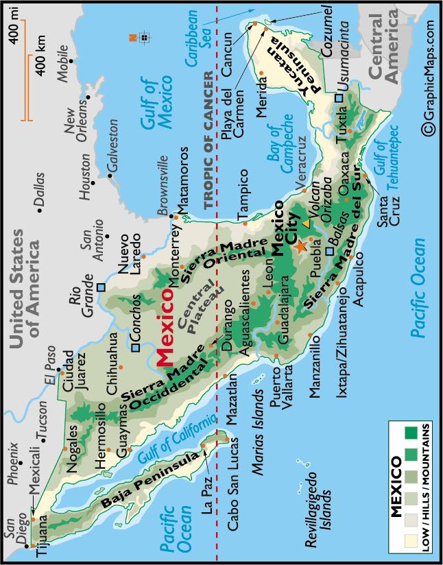
81 DID YOU KNOW? Mexico is a large, Spanish-speaking country in southern North America. In Spanish, the name of this country is Estados Unidos Mexicanos ( the United States of Mexico ). It is the fourth-largest country in the Western Hemisphere. Capital: Location: Area: Geography: Rivers: Mexico City (original name: Tenochtitlan) is one of the largest cities in the world. The metropolitan area has a population of about 20 million people. Mexico lies in both the northern and western hemispheres. It is positioned between the United States of America to the north and Guatemala and Belize to the south. At Mexico s west is the Pacific Ocean; to the east are the Gulf of Mexico and the Caribbean Sea. Almost 742,485 sq. miles (ca 2 million sq. km). It has 9,330 km of ocean coastline. The Sierra Madre Occidental and Sierra Madre Oriental mountain ranges border Mexico s elevated high desert, or Central Plateau (altiplano). Several smaller mountain ranges divide the landscape of southern Mexico, with the Sierra Madre del Sur the most significant. A long line of volcanoes, many still active, extends from the Pacific Ocean eastward to the Gulf of Mexico. Pico de Orizaba Volcano, the third highest mountain in North America, is located here. The very narrow coastal plain along the Pacific Ocean coastline rise quickly into the foothills of the mountains, while the Gulf of Mexico and Caribbean coastlines are wider and rise gently into the interior. The mountainous Baja Peninsula in the west extends about 750 miles (1200 km) south from the U.S. border. The Yucatan Peninsula to the east extends into the Gulf of Mexico and features thick tropical jungles. The Rio Grande begins in the San Juan Mountains of Colorado and flows generally south to the Gulf of Mexico for 1,885 miles (3000 km). It forms much of Mexico s northern border with the United States. Mexico has nearly 150 small, unnavigable rivers. 70% drain into the Pacific Ocean. Larger rivers include the Balsas, Conchos, Grijalva, Panuco, Papaloapan, Usumacinta. (Some not shown on the map for space reasons) Highest Point: Volcan Orizaba 18,701 ft. (5700 m) Lowest Point: Laguna Salada - 33 ft. (-10 m) Climate: States: Varies from hot deserts, forests, tropical rainforests, and some chapparal (scrub) along the northwestern coastline. Mexico is divided into 32 states (Aguas Calientes, Baja California, Baja California Sur, Campeche, Chiapas, Chihuahua, Coahuila, Colima, Durango, Estado de México, Guanajuato, Guerrero, Hidalgo, Jalisco, Michoacán, Morelos, Nayarit, Nuevo León, Oaxaca, Puebla, Querétaro, Quintana Roo, San Luis Potosí, Sinaloa, Sonora, Tabasco, Tamaulipas, Tlaxcala, Vera Cruz, Yucatán, Zacatecas) plus a Federal District (Mexico City). Language: Spanish, regional indigenous dialects 81
82 1. What is the capital of Mexico? 2. What country borders Mexico on the north? 3. What two countries border Mexico on the southeast? and 4. What ocean borders Mexico on the west? 5. What large body of water borders Mexico on the east? 6. Name the city in the far northwestern tip of Mexico that borders California. 7. What is the name of the desert in northwestern Mexico? 8. What is the name of the long peninsula on the northwest coast of Mexico that extends south from California? 9. Name the peninsula in southeastern Mexico. 82

83 The Caribbean Tropical Paradise 83

84 MAP OF THE CARIBBEAN 84
85 DID YOU KNOW? Although there are hundreds of Caribbean islands, we will explore the geography and climate of the six most populated Caribbean Islands. This section will include brief descriptions of: 1. Cuba 2. Haiti 3. Dominican Republic 4. Puerto Rico, a commonwealth of the United States 5. Jamaica 6. Trinidad and Tobago The Caribbean is a region formerly known as the West Indies. It is a popular region for tourism due to its vast beach land and delightful climate. The largest island of the West Indies is Cuba, one of four islands that make up the Greater Antilles archipelago, along with Jamaica, Hispaniola, and Puerto Rico. An archipelago is a large group or chain of islands. Cuba is the largest island and is located roughly 90 miles south of Miami, Florida. Cuba consists of a large island and 1,600 smaller islands. Though Cuba is mountainous, it also has rivers and streams and miles of beach land. Cuba has dry and rainy seasons. The island is subject to a hurricane season that lasts from June to November. The main language is Spanish. Cuba's capital is Havana. Haiti is the second largest island in the Caribbean and is located on Hispaniola, the same island as the Dominican Republic. The capital is Port-au-Prince. Haiti s official languages are French and Creole (a mix of French, African languages, Spanish, native Taíno, and English). Mountains make up most of Haiti and it has two peninsulas, the Northern Peninsula and the Southern Peninsula. There are many mountains where coffee and cacao beans are plentiful. Pic la Selle is the highest point on the island. Haiti has a tropical climate and is subject to hurricanes. Lake Azuei and Lake of Miragoane are the largest lakes. A massive earthquake hit parts of Haiti in January 2010, devastating its capital and surrounding areas. The Dominican Republic takes up roughly two-thirds of the eastern end of the island of Hispaniola. Santo Domingo is the capital. The country s official language is Spanish. The land is mountainous and includes Pico Duarte, the highest point in the Dominican Republic and in the Caribbean. The largest lake is Lake Enriquillo on the southwestern border. There are many smaller rivers and streams that run from the mountains to the sea. This island has a warm tropical climate. Puerto Rico is a commonwealth of the United States. Puerto Ricans are considered U.S. citizens, but they do not pay taxes to the U.S. and do not vote in U.S. elections. Puerto Rico s capital is San Juan. The island has rain forests. El Yunque rain forest provides a home to tropical animals such as the coquí, a tiny tree frog often no bigger than 1 inch (2.5 cm). It is believed that these islands were formed by volcanoes. There are four main land regions. They include the Coastal Lowlands, the Coastal Valleys, 85
86 the Foothills, and the Central Mountains. A large mountain range called the Cordillera Central is the backbone of the island. The island includes deserts, caves, and canyons. It is a popular tourist spot as the temperature stays around between F. year round. The island was devastated by Hurricane Maria in September Jamaica is located south of Cuba and is part of the Greater Antilles. Its capital is Kingston. The island has three land regions: coastal plains, central hills and plateau, and eastern mountains. Much of this island is mountainous. Jamaica has a hot, humid climate. The average temperature in the winter is 75 F. and in the summer 80 F. Temperatures in the mountains can drop to 40 F. The rainy season lasts from May through June and September through November. The rainiest months are May and October. Hurricanes season is June to November. The official language of Jamaica is English. Jamaica attracts large numbers of visitors each year. Trinidad and Tobago is a country in the southern Caribbean, which consists of two islands and is located off the coast of Venezuela. Port of Spain is both the national capital and the capital of Trinidad, the larger of the two islands. Scarborough is the capital of smaller Tobago. The highest mountain, Cerro del Aripo, which is more than 3,000 feet high, is located in the Northern Range. The average temperature is about 80 F. The official language is English, but many older people speak patois. This is a popular island for tourism. 86

87 Caribbean maps from 1. What is the capital of Cuba? 2. What three large bodies of water surround this island country?,, and 3. What is the closest U.S. state to Cuba? 4. What island is located southeast of Cuba? 5. Name the United States Naval Base located on Cuba s eastern side? This military base has been in the news of late. 6. What island country is located due south of Cuba? 87

88 1. Haiti shares an island with what other Caribbean country? 2. What is the capital of Haiti? 3. What happened in Haiti in January, 2010? 4. What is the highest point in Haiti? 5. What sea is located to the south of Haiti? 88

89 1. With what Caribbean country does the Dominican Republic share an island? 2. What is the capital of the Dominican Republican? 3. What ocean is situated to the east of the Dominican Republic? 4. What is the highest point in the Dominican Republic? 5. If you traveled from Puerto Rico to the Dominican Republic, what direction would you be traveling in? 89

90 1. What is the capital of Puerto Rico? 2. Name the four main land regions of this country?,,, and. 3. If you traveled from Puerto Rico to Mexico, what direction would you be traveling in? 4. What is Cordillera Central? 5. What is a coqui? How big is it?, 6. What ocean is located north of Puerto Rico? 90

91 1. What is the capital of Jamaica? What part of the country is it located in? 2. What country is located to the north of Jamaica? 3. What direction is Montego Bay from Kingston? 4. When does Jamaica experience hurricanes? 5. Name the mountains located in the eastern part of the country? 6. Name the site of the Columbus landing in

92 1. Name the South American country located to the west of Trinidad? 2. What is the capital of Trinidad-Tobago? 3. What direction is Tobago from the island of Trinidad? 4. What is the highest point on the island? 5. If you traveled from Florida to Trinidad-Tobago, what direction would you be traveling in? 92
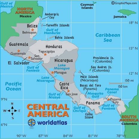
93 CENTRAL AMERICA Did you know? Central America was once part of the empire of the Maya people. The Maya civilization was at its peak between the years 250 and 900 A.D. The Maya built great cities and roads and made significant discoveries in science and mathematics. They developed a complex calendar and the most elaborate form of hieroglyphics, or picture writing, in America. In the 1500s the Spanish colonized all of Central America except Belize, which was colonized by England. Thus, Belize is the only country in Central America where English is the official and primary language spoken. There are seven countries in Central America: Belize, Costa Rica, El Salvador, Guatemala, Honduras, Nicaragua, and Panama. Central America is considered a sub-continent of North America. The countries in Central America share a warm tropical climate that is good for growing crops such as bananas, coffee, cacao, and cotton. The Panama Canal is 48 miles (77 km) in length and connects the Atlantic and Pacific Oceans. Construction on the canal began in 1904 and was completed in The canal was under U.S. control until the Panama Canal Authority assumed command of the waterway in This incredible engineering feat employs an intricate system of six massive locks. By travelling the canal, a ship travelling from New York to San Francisco travels roughly 9,500 miles, less than half the distance of the 22,500 miles that it would require to travel around Cape Horn, the southern tip of South America, which is known for its high winds and choppy seas. 93
94 94
.")
95 Central America Using a map, label the seven Central American countries (listed below) and color each a different color. Mark each country s capital with a star. Label the four bodies of water (also listed below). Mexico 95
96 Countries in Central America: Belize Located at the southeast border of Mexico and northeast of Guatemala Guatemala South of Mexico and west of Belize El Salvador Southeast of Guatemala and southwest of Honduras Honduras Northeast of El Salvador and northwest of Nicaragua Nicaragua Southeast of Honduras and north of Costa Rica Costa Rica South of Nicaragua and west of Panama Panama Southernmost tip of Central America, connects to Colombia Major Bodies of Water of Central America: Caribbean Sea Body of water east of Central America, part of the Atlantic Ocean Lake Nicaragua Located in Nicaragua, it is the largest lake in Central America Pacific Ocean Body of water west of Central America Panama Canal Waterway connecting the Atlantic and Pacific Oceans Interesting Facts of Central America Landforms The land is fertile and rugged, and dominated through its heart by a string of volcanic mountain ranges that are punctuated by a few active and dangerous volcanoes. The mountains of northern Central America are extensions of the mountain system in western North America and are related to the islands of the West Indies. The central portion of Central America contains active volcanoes and suffers from earthquakes, while the southern ranges are related to the Andes Mountain Range of South America. Highest Point Tajumulco Volcano in Guatemala at 13,845 ft. (4220 m) Temperatures Tropical to cool. Eastern Central America receives heavy rainfall. 96
 Size 8,867 sq.")
;")
 Costa Rica ( Rich Coast ) Capital")
 or approximately twice the")
; the")
97 At a Glance Belize Capital Belmopan (largest city: Belize City) Size 8,867 sq. mi. (22,965 km 2 ) or the approximate size of New Hampshire Borders Mexico (north); the Caribbean Sea (east); Guatemala (south and west) Costa Rica ( Rich Coast ) Capital San José Size 19,730 sq. mi. (51,100 km 2 ) or approximately twice the size of Maryland Borders Nicaragua (north); Caribbean Sea and Panama (east); the Pacific Ocean (south and west) 97


 Guatemala Capital Guatemala City")
 or the approximate size")
; Belize and the Caribbean Sea")
98 El Salvador Capital San Salvador Size 8,124 sq. mi. (21,040 km 2 ) or the approximate size of Massachusetts Borders Guatemala and Honduras (north); the Pacific Ocean (south) Guatemala Capital Guatemala City Size 42,042 sq. mi. (108,890 km 2 ) or the approximate size of Tennessee Borders Mexico (north and west); Belize and the Caribbean Sea (northeast); Honduras and El Salvador (east); the Pacific Ocean (south) 98
 or the approximate size of Louisiana Borders Caribbean Sea (north); Nicaragua")

99 Honduras Capital Tegucigalpa Size 43,433 sq. mi. (112,492 km 2 ) or the approximate size of Louisiana Borders Caribbean Sea (north); Nicaragua (southeast); the Pacific Ocean (south); El Salvador (southwest); Guatemala (west) Nicaragua Capital Managua Size 50,337 sq. mi. (130,373 km 2 ) or the approximate size of Alabama Borders Honduras (north); Caribbean Sea (east); Costa Rica (south); the Pacific Ocean (west) 99
 or the approximate size of South Carolina Borders")
; Colombia (east); the Pacific Ocean")
100 Panama Capital Panama City Size 28,640 sq. mi. (74,177 km 2 ) or the approximate size of South Carolina Borders Situated on the isthmus connecting North and South America. Caribbean Sea (north); Colombia (east); the Pacific Ocean (south); Costa Rica (west) 100
101 1. The two northernmost countries in Central America are Guatemala and Belize. Which North American country borders them to the north? 2. The country farthest south and east in Central America is Panama. What South American country borders Panama? 3. Ometepe Island, formed by two volcanoes rising from a lake, is one of the largest lake islands in the world and is the largest in Central America. What is the name of the largest lake in Central America where Ometepe is located? 4. Most Central American countries have both an Atlantic and Pacific coast. The only one that does not border the Pacific Ocean is also the only Central American country without a volcano. Name this country. 5. An isthmus is a narrow strip of land with water on two sides. It connects two larger land-masses. Which of the Central American countries is located on an isthmus connecting North and South America? 6. The Panama Canal is approximately 50 miles long. Prior to its completion in 1914, ships sailing from California to New York had to travel around the dangerous Cape Horn at the southern tip of South America. Now it takes only eight hours to cross the Panama Canal! Which two oceans are connected by this waterway? 7. The Caribbean Sea is part of the Atlantic Ocean. What is the only Central American country that does not border the Caribbean Sea? 8. Spanish is the official language of all Central American countries except for Belize, where English is considered official. What is the capital of Belize? 101
102 9. The capital of Panama has nearly one million people, which is roughly one quarter of the country s population. Name the capital. 10. Name the river that separates Nicaragua from Costa Rica, to the south. 11. The highest elevation in Central America is the crater on the volcano Tajumulco in the same country as Lake Izabal. Which country is it in? 12. The capital of El Salvador was built on a volcanic slope and has suffered from severe earthquakes. It has been rebuilt frequently. Name this city. 13. An earthquake destroyed Guatemala s former capital, Antigua, in The capital was moved in 1776 to its present location and a new city was founded. Name the city that is now the capital of Guatemala. 14. Much of northern Central America was once a part of the empire of the Maya Indians. Many spectacular Maya sites can be explored in the country of Honduras. Name its capital. 15. San José is the capital of which Central American country? 102
103 Did you know? SOUTH AMERICA South America is the fourth largest continent in the world, after Asia, Africa, and North America. There are 12 independent countries (Argentina; Bolivia; Brazil; Chile; Colombia; Ecuador; Guyana; Paraguay; Peru; Suriname; Uruguay; and Venezuela), and an overseas department (French Guiana). The Equator dissects three South American countries. The Tropic of Capricorn, one of the five major lines of latitude dividing the Earth, extends through four South American countries. The Amazon River is often called the greatest river in the world. It carries approximately 20 percent of all the fresh water discharged into the oceans. The Amazon is also one of the longest rivers in the world. You will find several extremes within South America: Highest waterfall Angel Falls, Venezuela: 3,212 ft. (979 m) Largest river (by volume) Amazon River Basin: 2,720,000 sq. mi. (7,050,000 km 2 ) Longest mountain range Driest nonpolar desert Andes: 4,300 miles (7,000 km), north/south along the western coast of the continent, running from Panama to Chile Atacama Desert, Chile: 1 mm rain (0.04 inch) per year Largest rainforest Amazon Rainforest, Brazil: 1.4 billion acres (5,500,000 km 2 ). Highest capital city La Paz, Bolivia: ca. 12,000 ft. (3,660 m) Highest commercially navigable lake in the world Lake Titicaca, on the border of Peru and Bolivia: 12,500 ft. (3,811 m) The southernmost permanently-inhabited community Puerto Toro, Chile: 2,423 miles (3,900 km) from the South Pole 103

104 Major Landforms 104
105 AMAZON BASIN ANDES The Amazon Basin (Amazonia) is covered by the largest tropical rain forest in the world. Running through its heart is the Amazon River and its more than 1,000 tributaries, seven of which are more than 1,000 miles in length. Measurable rain falls on an average of 200 days a year, and total rainfall approaches 100 inches per year. The overall basin drains more than 2,700,000 sq. miles and covers about one-third of the South American landmass. Rising high in the Andes, the river s network irrigates almost half of the continent and discharges the largest volume of water into an ocean. This toothy-edged, massive mountain system extends from Panama to the tip of South America. It s the source of most major rivers on the continent and is about 4,300 miles (7,000 km) in length. It is home to some of the planet s largest volcanoes, and in the far south along the coast of Chile, large ice sheets are commonplace. The Andes and its many ranges include dozens of peaks that reach more than 20,000 ft. The highest point is Mount Aconcagua in Argentina, at 22,837 ft. (6,960 m). ATACAMA DESERT Sparsely populated and running high into the Andes of Chile, this small desert is a cold place, and rainfall is very rare. It is approximately 100 miles wide and 625 miles long. The landscape is totally barren and covered with small borax lakes, lava flow remnants and saline deposits. BRAZILIAN HIGHLANDS This highland region - about 800 miles in length - runs through southeastern Brazil. The magnificent landscape includes varied mountain ranges (the Serra de Mantiquiera, Serra do Paranapiataba, Serra Geral, and Serra do Mar). The highest point in the Brazilian Highlands is Pico da Bandeira at 9,488 ft. (2,892 m) GUIANA HIGHLANDS A geographically stunning part of Earth, over 1,000 miles in length, the Highlands stretch from southern Venezuela across the northern edge of South America to the tip of Brazil. 105
106 It consists of a vast plateau, marked by deep gorges, tropical rain forests, numerous rivers and waterfalls. It is famous for the highest waterfall in the world, Angel Falls, at 3,212 ft. (979 m) high. The highest point is Mt. Roraima on the borders of Brazil, Guyana and Venezuela at 9,220 ft. (2,810 m). LOS LLANOS PAMPAS This large and very fertile plain (the Spanish word for plains is llanos), located in eastern and central Colombia, and central and southern Venezuela, is drained by the Orinoco River and its many tributaries. It is approximately 225,000 sq. mi. (582,000 km 2 ) in size. Famed for its many cattle ranches, this large plain in the southern part of the continent in central Argentina extends for almost 1,000 miles (1,600 km) and covers 294,000 sq. miles (761,460 km 2 ). PATAGONIA Located between the Andes and the Atlantic Ocean, and about 1,000 miles in length, Patagonia stretches from southern Argentina to Tierra del Fuego and the Strait of Magellan. It is mostly rugged, barren land, known for its beauty and striking scenery. 106
107 South America Reference Map Color each country a different color. Color the bodies of water blue. 107
108 1. What ocean lies to the east of South America? 2. Name the mountain range located on the western coast of South America. 3. What ocean lies to the west of South America? 4. What is the name of the sea to the north of South America? 5. The equator crosses which three countries of South America?, and 6. What is the largest country in South America? 7. Name the two landlocked countries in South America. and 8. If you were to walk from Central America to South America, what South American country would you enter first? 9. What country is bordered by Ecuador, Colombia, Brazil, Bolivia, and Chile? 10. If you were to travel from Venezuela to Argentina, in which direction would you travel: north, south, east, or west? 11. What is the name of the British islands off the eastern coast of Argentina? 12. Name the southern tip of South America. 13. What is the name of the waterway at the southern tip of South America, named after a 16 th century Portuguese explorer? 14. The seasons in the Southern Hemisphere (south of the equator) are at opposite times of the year from seasons in the Northern Hemisphere. If it is winter in Argentina, what season is it in the United States? 108
 French Guiana (Cayenne) Guiana (Georgetown) Paraguay (Asuncion) Peru (Lima) Suriname (Paramaribo) Uruguay (Montevideo) Venezuela")
109 South American Capitals Argentina (Buenos Aires) Bolivia (La Paz and Sucre) Brazil (Brasilia) Chile (Santiago) Colombia (Bogota) Ecuador (Quito) French Guiana (Cayenne) Guiana (Georgetown) Paraguay (Asuncion) Peru (Lima) Suriname (Paramaribo) Uruguay (Montevideo) Venezuela (Caracas) 109
110 1. Bolivia has two capitals. The first is Sucre, the judicial capital. Located about 12,000 feet above sea level, the second capital of Bolivia is the world s highest capital city. Name that city. 2. Argentina is the second largest country in South America. What is its capital? 3. What is the capital of Venezuela, which borders the Caribbean Sea? 4. In Guyana, English is the official language. The capital of Guyana has an English name that is also the name of a neighborhood in Washington D.C. Name the capital. 5. French Guiana is not an independent country. It is part of France, so its largest city cannot be considered a capital city. Name this city, which is also a word for a kind of hot red pepper. 6. This is the largest country in South America and the only country in South America where Portuguese is the official language. Most of this country s people live in the Atlantic coastal cities but the capital city is not near the coast. Name the country.. Its capital is. 110
111 7. Uruguay is the second smallest country in South America and most of the land is low lying grassland, perfect for raising sheep and cattle. What is the capital of Uruguay? 8. Ecuador is the world s leading banana producer. What is its capital? 9. This country on the west coast of South America is long (2,560 miles) and very narrow (no more that 270 miles wide). Name the country and its capital is 10. Paramaribo is the capital of the smallest independent country in South America. What is the name of the country? 11. Paraguay is a landlocked country in South America with two very large neighbors: Brazil and Argentina. What is the capital of Paraguay? 12. Colombia is the only country in South America with coastlines on both the Pacific Ocean and the Caribbean Sea. Name the capital of Colombia. 13. The source of the vast Amazon River lies in a remote part of Peru on the Pacific coast of South America. What is the capital of Peru? 111
112 Did you know? South America: The Northern Countries Colombia, Venezuela, Guyana, Suriname, French Guiana Bogota, the capital of Colombia sits high in the Andes Mountains at an altitude of over 8,660 feet (2,640 m), making it the third-highest capital in the world after La Paz, Bolivia and Quito, Ecuador. One of the most popular exports of Colombia is coffee. Colombia is the only country in South America with coastlines on the Pacific Ocean and the Caribbean Sea. Venezuela s Lake Maracaibo is the largest lake in South America. Angel Falls in Venezuela is the world s highest waterfall with a drop of 3,212 ft. (979 m). Guyana is an American Indian word meaning land of many waters. Guyana is the only English-speaking country of South America. Suriname, made up of rolling hills and a narrow coastal plain with swamps, is the smallest country of South America. As a former Dutch colony, Dutch is still spoken there. Suriname is named after its earliest inhabitants, the Surinen Indians. French Guiana, which is an overseas department of France, is the largest part of the European Union outside of Europe. The currency in French Guiana is the Euro just like in France and the European Commonwealth. 112
 Borders: Caribbean Sea (north); Venezuela and Brazil (east); Peru and Ecuador (south);")
113 Colombia Capital: At a Glance Bogotá Size: 440,831 sq. mi. (1,141,748 km 2 ) Borders: Caribbean Sea (north); Venezuela and Brazil (east); Peru and Ecuador (south); the Pacific Ocean (west); and Panama (northwest) 113
114 1. What is the capital of Colombia? 2. Which ocean borders Colombia to the west? 3. What is the name of the country that borders Colombia on the east? 4. Name the three countries that border Colombia to the south?,, and 5. The imaginary geographic circle located halfway between the Earth s poles runs through southern Colombia. What is it called? 6. What is the name of the river that runs along the southernmost border of Colombia? 7. In which part of Colombia is Santa Maria located (north, south, east, west)? 8. The tallest peak in Colombia, located in the north, is the fifth tallest peak in the world. What is its name? 9. If you wanted to travel from Bogotá to Pasto, in which direction would you head? 10. Roughly how many miles is it from Bogotá to Medellin: 10 miles, 100 miles, or 1,000 miles? 114
 Borders: Caribbean Sea (north); Guyana (east);")

115 Venezuela Capital: Caracas Size: 353,841 sq. mi. (916,445 km 2 ) Borders: Caribbean Sea (north); Guyana (east); Brazil (south); and Colombia (west) 1. What is the capital of Venezuela, located near the Caribbean Sea?. 2. Name Venezuela s neighbor to the west. 115
116 3. Located in the east of Venezuela is the world s tallest waterfall at 3,212 ft. (979 m). Name the waterfall. 4. Name Venezuela s large northern lake, which is connected via a dredged canal to the Caribbean Sea. It is the largest lake in South America. 5. What is the name of the large body of water to the north of Venezuela? 6. Which river flows west/east and empties into the Atlantic Ocean? 7. Which country lies to the south of Venezuela? 8. Is Venezuela s capital located in the north or the south of the country? 116

; Suriname (east); Brazil (south")
117 Guyana Capital: Georgetown Size: 83,000 sq. mi. (214,970 km 2 ) Borders: Atlantic Ocean (north); Suriname (east); Brazil (south and southwest); Venezuela (west) 117

; French Guiana (east);")
118 Suriname Capital Paramaribo Size 63,251 sq. mi. (163,821 km 2 ) Borders Atlantic Ocean (north); French Guiana (east); Brazil (south); Guyana (west) 118
 Borders: Brazil (east and south); Suriname")
119 French Guiana Capital: Cayenne Size: 32,253 sq. mi. (83,534 km 2 ) Borders: Brazil (east and south); Suriname (west) 119
120 1. This country, situated between Guyana and French Guiana, was a former Dutch colony and gained its independence from the Netherlands in Its official language is Dutch, and has two cities on the Atlantic coast that further reveal its Dutch background. Name the country. 2. Name the ocean, which lies to the north of Guyana, Suriname and French Guiana. 3. At one time, European countries controlled all of South America. Today, only one such colony remains: French Guiana. It is an overseas department of France whose capital city is also the name of a spice known for its hotness. Name the city. 4. Name the landform that covers most of Guyana s north. 5. Which large South American country border French Guiana to the south and east? 6. Guyana is situated between which two countries? and 120
121 South America: The Eastern Countries Brazil and Uruguay Did you know? Brazil is the world s fifth largest country, after Russia, Canada, China, and the United States. It is the largest country in South America. Brazil is larger in size than the contiguous USA. Brazil hosts most of the jungles of the Amazon, the largest tropical rainforest in the world and is home to the world s richest and most diverse ecosystem. The Amazon is the largest river by volume in the world and the second longest river, after the Nile in Africa. Brazil exports coffee, soybeans, sugarcane, cocoa, rice, livestock, corn, oranges, cotton, wheat, and tobacco; minerals; and airplanes. The Pantanal in Brazil is the world s largest wetland and home to over 200 bird species. Brazil is the only Portuguese-speaking country in South America. Brazil s coastline is 4,655 miles (7,491 km) long. Compare it to California s coastline, which is 840 miles long. Uruguay is the second smallest country in South America after Suriname. An estimated 88% of the population in Uruguay is of European descent. 121
 Borders: Venezuela, Guyana, Suriname and")
; Peru (west); and")
122 Brazil Capital: Brasilia Size: 3,287,597 sq. mi. (8,514,877 km 2 ) Borders: Venezuela, Guyana, Suriname and French Guiana (north); Atlantic Ocean (east); Uruguay (south); Argentina, Paraguay and Bolivia (southwest); Peru (west); and Colombia (northwest). 122
123 1. What is the capital of Brazil? 2. What ocean borders Brazil to the east? 3. What is the name of the huge rainforest in northern Brazil? 4. Does the Amazon River flow across Brazil from north to south or from east to west? 5. The coastal city is famous for its beautiful beaches, Sugarloaf Mountain, and the yearly festival called carnival. Its name means January River. Name the city. 6. Name the country that borders Brazil to the south along the Atlantic Ocean. 7. If you wanted to travel from São Paulo to Brasilia, in which direction would you head? 8. Roughly how many kilometers is it from Rio de Janeiro to Brasilia: 50 km, 500 km, 1,000 km or 5,000 km? 123

; Atlantic Ocean (east")
124 Uruguay Capital: Montevideo Size: 68,037 sq. mi. (176,215 km 2 ) Borders: Brazil (north); Atlantic Ocean (east and south) 124
125 South America: The Central and Southern Countries Did you know? Bolivia, Paraguay and Argentina Bolivia is the highest elevated and most isolated of the South American republics. At approximately 12,000 ft., La Paz is the world s highest capital. Bolivia has two capital cities: La Paz is the administrative capital where the president and Congress live, and Sucre is the judicial capital. With 65% of its population belonging to Quechua and other indigenous groups, Bolivia has the largest Native American population in South America. Bolivia s Lake Titicaca is the highest navigable body of water in the world at an elevation of 12,500 feet above sea level (3,810 m). It is South America s second largest lake behind Venezuela s Lake Maracaibo. Due to its central location in South America, Paraguay is sometimes referred to as Corazón de América, (Heart of America). The Tropic of Capricorn, an imaginary line, which marks the most southerly latitude at which the sun can appear directly overhead passes through Bolivia, Paraguay, Argentina, and Chile. That event occurs at the December solstice, when the southern hemisphere is tilted towards the sun to its maximum extent. Paraguay and Bolivia are South America s only landlocked countries. The Pampas, in the center of Argentina, is the largest and best-known area of plains and grassland. Argentina s main geographic characteristic is the great contrast between the immense eastern plains and the impressive Andes mountain range to the west. Argentina and Great Britain went to war in 1992 over the Falkland Islands, a group of islands roughly 400 miles east of the Strait of Magellan. Iguaza Falls, bordered by Argentina, Paraguay, and Bolivia, are a collection of 275 falls. From the southern most tip of Argentina, to the northern-most tip of the Antarctic Peninsula, it is about 1,000 km. 125
126 126
 Borders: Brazil (north and east); Paraguay and Argentina (south); Chile and Peru")
127 Bolivia Capital: La Paz (seat of government) and Sucre (judicial capital) Size: 424,000 sq. mi. (1,100,000 km 2 ) Borders: Brazil (north and east); Paraguay and Argentina (south); Chile and Peru (west) 127
128 1. Name the two capitals of Bolivia. and 2. What country borders Bolivia to the north and east? 3. This lake lies between Bolivia and Peru. Its elevation makes it the highest navigable lake in the world. What is the name of the lake? 4. If you were to travel west from La Paz, what country would you enter? 5. If you were to travel south from Tarija, what country would you enter? 6. What is the name of the country that borders Bolivia to the southwest? 7. Name the mountain range that extends into the southwest of Bolivia. 8. What country borders Bolivia to the southeast? 9. If you wanted to travel from La Paz to Cobija, in which direction would you head? 10. Roughly how many miles is it from La Paz to Sucre, the judicial capital: 30 miles, 300 miles, or 3,000 miles? 128
 Borders: Brazil (east and northeast); Argentina (south and")
129 Paraguay Capital: Asuncion Size: 157,048 sq. mi. (406,752 km 2 ) Borders: Brazil (east and northeast); Argentina (south and southwest); Bolivia (northwest) 129
130 1. Which country lies to the west of the capital? 2. Name Paraguay s capital. 3. Which major latitudinal line crosses Paraguay just south of Concepcion? 4. Which country is situated to the east of Paraguay? 5. Name the large waterfall that lies in the eastern border of Paraguay? 6. What direction are you heading when you travel to these large falls from Paraguay s capital? 130
 Borders Bolivia and Paraguay (north), Brazil (northeast); Uruguay and Atlantic Ocean")
131 Argentina Capital Buenos Aires ( Good Air ) Size 1,073,518 sq. mi. (2,780,400 km 2 ) Borders Bolivia and Paraguay (north), Brazil (northeast); Uruguay and Atlantic Ocean (east) and Chile (south and west). 131
132 1. What is the capital of Argentina? 2. At more than 22,000 feet (6,705 m), this mountain located in Argentina is the highest mountain in the world outside of Asia. Name the mountain. 3. What ocean borders Argentina to the east? 4. What country borders Argentina to the west? 5. Name the islands, belonging to the United Kingdom, off the southeastern coast of Argentina. 6. Tierra del Fuego ( Land of Fire ) is a rugged group of islands separated from mainland Argentina by the Strait of Magellan. In what part of Argentina is it located (north, south, east or west)? 7. What is the name of the cape where the Pacific and Atlantic Oceans meet at the southernmost tip of South America? Dangerous Roaring Forties winds make this area especially dangerous for ships. 8. Roughly how many miles is it from Buenos Aires to Mendoza: 40 miles, 400 miles or 4,000 miles? 132
133 South America: The Western Countries Did you know? Ecuador, Peru and Chile Despite its small size, Ecuador is a land of great geographical diversity. Tropical rainforests, the high slopes of the Andes, and the Pacific coastline are all within a few hours drive. Ecuador is the largest exporter and 5 th largest producer of bananas in the world. Ecuador includes the Galapagos Islands, which are situated about 1,000 miles west of the mainland in the Pacific Ocean, and which are famous for their unusual wildlife, including giant tortoises, and home to Darwin s Theory of Evolution. Ecuador s name comes from its position relative to the equator. Cuzco, Peru was the capital of the ancient Incan empire, which stretched from modern-day Colombia south to Chile. Incans ruled western South America between 1400 and 1532, when Spanish invaders captured their Emperor, Atahualpa. The name Peru is derived from a Quechua Indian word meaning land of abundance, a reference to the economic wealth produced by the highly organized Inca civilization. The mighty Amazon River originates from the Apacheta cliff in Arequipa at the Nevado Mismi in the Peruvian Andes, roughly 99 miles (160 km) west of Lake Titicaca and 430 miles (700 km) southeast of Lima. Northern Chile is home to the world s driest desert, the Atacama Desert, where annual rainfall in some regions has measured only 1 mm. Chile, a long and narrow country, is 2,700 miles long (4,300 km) and 109 miles wide (175 km). Its Pacific coastline is roughly 4,000 miles long (6,435 km). Chile s territory includes Easter Island, one of the easternmost islands of Polynesia in the Pacific Ocean. The island is located about 2,300 miles west of Chile and is also known as Isla de Pascua or Rapa Nui. The island is home to the famous Naunau (Easter Island) statues made of soft volcanic rock. 133
 Borders Colombia (north), Peru (east and south), and the Pacific Ocean (west) Galapagos")
134 Ecuador Capital Quito Size 109,484 sq. mi. (283,560 km 2 ) Borders Colombia (north), Peru (east and south), and the Pacific Ocean (west) Galapagos Islands and their positioning in relationship to Ecuador 134
135 1. What is the capital of Ecuador? 2. What ocean borders Ecuador to the west? 3. What is the name of the country that borders Ecuador to the north? 4. What is the name of the country that borders Ecuador to the south and east? 5. Name the mountain range that runs through Ecuador. 6. What is the name of the island chain situated 1,000 miles west of Ecuador? 7. If you wanted to travel from Quito to Ambato, in which direction would you head -- north, south, east or west? 8. Estimate how many miles it is from Quito to La Libertad: 40 miles, 400 miles or 4,000 miles. 135
136 Peru Capital Lima Size 496,225 sq. mi. (1,285,216 km 2 ) Borders Ecuador and Colombia (north); Brazil (east); Bolivia (southeast); Chile (south); and the Pacific Ocean (west) 136
137 1. What is the capital of Peru? 2. What ocean borders Peru to the west? 3. What is the name of the country that borders Peru to the northwest? 4. What is the name of the major river that originates in Peru and flows through the northeast into Brazil? 5. What is the name of the country that borders Peru to the south along the ocean? 6. If you traveled east from Cusco, what country would you eventually enter? 7. If you wanted to travel from Lima to Huancayo, in which direction would you head? 8. Roughly how many miles is it from Lima to Ica: 20 miles, 200 miles, or 2,000 miles? 137
 Borders Peru (north), Bolivia (northeast), Argentina (east), and the Drake Passage (south), the Pacific Ocean (west) 1.")
138 Chile Capital Santiago Size 291,930 sq. mi. (756,096 km 2 ) Borders Peru (north), Bolivia (northeast), Argentina (east), and the Drake Passage (south), the Pacific Ocean (west) 1. What is the capital of Chile? 2. What ocean borders Chile to the west? 3. What is the name of the country that borders Chile to the northwest? 138


139 4. What is the name of the country along most of Chile s eastern border? 5. What is the name of the strait that cuts through southern Chile, named for a famous 16 th century Portuguese explorer? 6. Name the north Chilean desert known as the driest place on Earth. 7. Roughly how many miles is it from Santiago to Puerto Montt: 50 miles, 500 miles, or 5,000 miles? 8. Name the island in the Pacific Ocean that is a territory of Chile. KNOW YOUR WORLD! 139
Curriculum Pacing Guide Grade/Course 5 Th Grade Geography Grading Period 1 st Nine Weeks
 2013-2014 Curriculum Pacing Guide Grade/Course 5 Th Grade Grading Period 1 st Nine Weeks Time Frame Unit/ photographs, pictures, and tables to Locate and identify: Continents and Oceans -North America
2010 Teacher Created Resources, Inc.
 Editor Heather Douglas Illustrator Kevin McCarthy Cover Artist Kevin Barnes Editor in Chief Ina Massler Levin, M.A. Creative Director Karen J. Goldfluss, M.S. Ed. Art Coordinator Renée Christine Yates
APPENDIX B AUTHORIZED SECTIONS of the SOCIETY OF MOTION PICTURE AND TELEVISION ENGINEERS with GEOGRAPHICAL BOUNDARIES (Revised )
") APPENDIX B AUTHORIZED SECTIONS of the SOCIETY OF MOTION PICTURE AND TELEVISION ENGINEERS with GEOGRAPHICAL BOUNDARIES (Revised 12-12-2008) ATLANTA SECTION - Southern Region Alabama (Part) by choice Florida
APPENDIX B AUTHORIZED SECTIONS of the SOCIETY OF MOTION PICTURE AND TELEVISION ENGINEERS with GEOGRAPHICAL BOUNDARIES (Revised 12-12-2008) ATLANTA SECTION - Southern Region Alabama (Part) by choice Florida
TOGETHER, MAKING BOATING THE PREFERRED CHOICE IN RECREATION RECREATIONAL BOATING ECONOMIC STUDY $ $
 2012 TOGETHER, MAKING BOATING THE PREFERRED CHOICE IN RECREATION RECREATIONAL BOATING ECONOMIC STUDY In 2013 NMMA s Center of Knowledge contracted with the Recreational Marine Research Center at Michigan
Geography Quiz: State Capitals
 Geography Quiz: State Capitals Directions: Select the correct capital city for each state in the United States of America. 1. Alabama a. Jackson b. Montgomery c. Jefferson city d. Augusta e. Boston 6.
The Land Photo Source: The Atlas of Canada, The Red River, Manatoba, Canada land/physio_red_ri
 The Land The United States and Canada An Overview of the Region The United States and Canada are the two largest countries in North America. The Rio Grande is part of the southwest border of the United
Geography: Unit 2. Map. Rivers. Major Physical Features. Slide 1. Slide 2. Slide 3. Slide 4. North America United States and Canada.
 Mississippi River Slide 1 Slide 2 Slide 3 Slide 4 Geography: Unit 2 North America United States Map Major Physical Features Mountain Ranges Brooks Range Mackenzie Mountains Coast Mountains Cascades Sierra
A. Library s Collection Development Objectives B. Curricular Program Description C. New and Expanding Areas of Interest D. Areas of Specialization
 HISTORY COLLECTION GUIDELINES CLASS IFICATION F I. Purpose and Program Description A. Library s Collection Development Objectives The primary purpose of the collection is to support teaching and research
 RUSSIA OR CA WA AK NV CANADA ID UT AZ MT WY CO NM MEXICO HI ND SD NE KS TX MN OK CANADA IA WI LA IL MI IN OH WV VA FL ME VT NH MA NY CT NJ PA MO KY NC TN SC AR AL GA MS MD BAHAMAS CUBA RI DE 3 RUSSIA 1
TOURIST ARRIVALS REPORT
 No. of Arrivals TOURIST ARRIVALS REPORT Stay Over Arrivals by Market (, 217) 16, 14, 12, 1, 8, 6, 4, 2, USA UK Caribbean Canada Rest of Europe Germany France Rest of World 216 13,454 5,969 4,154 5,881
TOURIST ARRIVALS REPORT
 No. of Arrivals TOURIST ARRIVALS REPORT Stay Over Arrivals by Market (March, 217) 18, 16, 14, 12, 1, 8, 6, 4, 2, USA UK Caribbean Canada Rest of Europe Germany France Rest of World 216 15,61 6,61 5,57
TOURIST ARRIVALS REPORT
 No. of Arrivals TOURIST ARRIVALS REPORT Stay Over Arrivals by Market (June, 217) 18, 16, 14, 12, 1, 8, 6, 4, 2, USA UK Caribbean Canada Rest of Europe Germany France Rest of World 216 15,24 3,941 4,425
 Chapter Name Albuquerque Ann Arbor Augusta Baton Rouge Bayou Oncology (C'est Bon) Big Sky Bluegrass Blue Ridge of Virginia Bluewater International Boston Broward Florida Bucks Montgomery Counties California
Political Event Recreational Event Federal Holiday ~ January 2012 ~ Sun Mon Tue Wed Thu Fri Sat 1 2 New Year s Day (Federal Holiday) 5 -Progressive
 5 -Progressive") Political Event Recreational Event Federal Holiday ~ January 2012 ~ 1 2 New Year s Day (Federal Holiday) 8 -Progressive Insurance New York Boat Show. New York City, NY Partners Outdoors 2012, Williamsburg,
Political Event Recreational Event Federal Holiday ~ January 2012 ~ 1 2 New Year s Day (Federal Holiday) 8 -Progressive Insurance New York Boat Show. New York City, NY Partners Outdoors 2012, Williamsburg,
Geography: Unit 2. Map. Major Physical Features. Rivers. Mississippi River Missouri River Ohio River Rio Grande. Mackenzie. Colorado River Green River
 1 2 3 4 Geography: Unit 2 North America United States and Canada Map Major Physical Features Mountain Ranges Brooks Range Mackenzie Mountains Coast Mountains Cascades Sierra Nevada Rocky Mountains Appalachian
Approved FY 2002 Waivers (42**) (10)
 (10)") Summary of Requests to Waive 7 CFR 273.24 Pending FY 2003 Waivers (1) Approved FY 2003 Waivers (43*) Approved FY 2002 Waivers (42**) No Current Waivers (9) Indian Reservations (10) Maine Alabama*** Nevada
Summary of Requests to Waive 7 CFR 273.24 Pending FY 2003 Waivers (1) Approved FY 2003 Waivers (43*) Approved FY 2002 Waivers (42**) No Current Waivers (9) Indian Reservations (10) Maine Alabama*** Nevada
Q1 Arrival Statistics. January-March 2015
 Q1 Arrival Statistics January-March 2015 Q1 Total Air Arrivals Visitor Expenditure The average per person expenditure increased by $278 vs. Q1 2014. Overall this increase in spend contributed over $6M
Statistical Report of State Park Operations:
 National Association of State Park Directors Statistical Report of State Park Operations: 2011-2012 Annual Information Exchange for the Period July 1, 2011 through June 30, 2012 Prepared for the National
VISITOR ARRIVALS REPORT
 No. of Arrivals VISITOR ARRIVALS REPORT Stay Over Arrivals by Market (September, 217) 9, 8, 7, 6, 5, 4, 3, 2, 1, USA UK Caribbean Canada Rest of Europe Germany France 216 7,91 3,874 4,36 1,134 374 6 114
KEY BENEFITS STANDARD FEATURE(S) Easy to install Easy to clean White acrylic COMMON OPTIONS
 Easy to install Easy to clean White acrylic COMMON OPTIONS") Codes/Standards Applicable ANSI Z124.1.2 CSA B45 Series Whirlpool Bathtubs: UL1795 ASME A112.19.7 CSA C22.2. 218.2 CSA B45.10 KEY BENEFITS Ample deck space for faucet installation Flexible design to fit
Codes/Standards Applicable ANSI Z124.1.2 CSA B45 Series Whirlpool Bathtubs: UL1795 ASME A112.19.7 CSA C22.2. 218.2 CSA B45.10 KEY BENEFITS Ample deck space for faucet installation Flexible design to fit
TABLE 1 VISITOR ARRIVALS. Total Visitor Arrivals +/ Month / / /18
 TABLE 1 VISITOR ARRIVALS Stopover Arrivals +/ Cruise Passengers +/ Total Visitor Arrivals +/ Month 2018 2019 2019/18 2018 2019 2019/18 2018 2019 2019/18 January 194,609 216,509 11.3% 249,635 249,239 0.2%
Census Affects Children in Poverty by Professors Donald Hernandez and Nancy Denton State University of New York, Albany
 Phone: (301) 457-9900 4700 Silver Hill Road, Suite 1250-3, Suitland, MD 20746 Fax: (301) 457-9901 Census Affects in Poverty by Professors Donald Hernandez and Nancy Denton State University of New York,
COPYRIGHT: The Arizona Historical Society owns the copyright to this collection.
 TITLE: Arizona Historical Foundation Postcard Collection DATE RANGE: 1900s- 1980s CALL NUMBER: FP FPC #3 PHYSICAL DESCRIPTION: 5.5 linear feet (10 boxes) PROVENANCE: Collection of vintage postcards from
AVSP 7 Summer Section 7: Visitor Profile - Demographics and Spending
 AVSP 7 Summer 2016 Section 7: Visitor Profile - Demographics and Spending Demographics Origin Visitors were asked what state, country, or province they were visiting from. The chart below shows results
SGS ACCUTEST STATE CERTIFICATIONS, ACCREDITATIONS, AND PERMITS BY STATE
 Alaska UST-103 5/4/2017 Dayton, NJ Alaska UST-088 8/21/2017 Orlando, FL Arizona AZ0786 9/9/2017 Dayton, NJ Arizona AZ0769 7/12/2017 Houston, TX Arkansas 16-027-0 3/28/2017 Houston, TX Arkansas 16-050-0
Requests by Intake and Case Status Period. Intake 1 Case Review 6
 Number of Form I-821D,Consideration of Deferred Action for Childhood Arrivals, by Fiscal Year, Quarter, Intake and Case Status Fiscal Year 2012-2018 (March 31, 2018) Requests by Intake and Case Status
WHO Report on the Global Tobacco Epidemic, Appendix IV - Table 3
 WHO Report on the Global Tobacco Epidemic, 2009 Appendix IV - Table 3 Subnational smoke-free environments 1 protect: smoke-free environments Table 4.3.0 Subnational smoke-free environments 1 Data not approved
ustravel.org/travelpromotion
 Agenda 1. Power of Travel Promotion Resources 2. New Tool: Travel Economic Impact Calculator 3. Accessing data through Interactive Travel Analytics 4. Unused Vacation Time Opportunity 5. Highlights from
Land Information Ontario Data Description. OHN 2M Waterbody
 Unclassified Land Information Ontario Data Description OHN 2M Waterbody Disclaimer This technical documentation has been prepared by the Ministry of Natural Resources (the Ministry ), representing Her
DOWNTOWN, CHARLOTTE AMALIE
 TOTAL VISITOR ARRIVALS TO THE USVI : DECEMBER YEAR TO DATE DECEMBER TOTAL VISITOR ARRIVALS 2,85, 2,8, 2,814,257 2,75, 2,7, 2,65, 2,6, 2,642,118 2,71,542 2,648,5 2,55, 212 213 214 215 Visitor arrivals ended
MapInfo Routing J Server. United States Data Information
 MapInfo Routing J Server United States Data Information Information in this document is subject to change without notice and does not represent a commitment on the part of MapInfo or its representatives.
CSC Agent Office Addresses
 CSC Agent Office Addresses Alabama Montgomery, Inc. 641 South Lawrence Street Montgomery, AL 36104 Montgomery County Arizona Phoenix 2338 West Royal Palm Road, Suite J Phoenix, AZ 85021 Maricopa County
1. STATEMENT OF MARKET SERVED Corporate exhibit, event and trade show managers and suppliers to the exhibition industry.
 EVENT AUDIT DATES OF EVENT: Conference: February 25 March 1, 2018 Exhibits: February 26 28, 2018 LOCATION: Mandalay Bay Convention Center, Las Vegas EVENT PRODUCER/MANAGER: Company Name: Hall-Erickson,
Mandalay Bay Convention Center, Las Vegas. Address: 98 E. Chicago Avenue, Suite 201 Westmont IL Phone:
 EVENT AUDIT DATES OF EVENT: Conference: March 12 16, 2017 Exhibits: March 13 15, 2017 LOCATION: Mandalay Bay Convention Center, Las Vegas EVENT PRODUCER/MANAGER: Company Name: Hall-Erickson, Inc. Address:
Human Geography of Canada
 Human Geography of Canada History and Government of Canada Like the United States, people migrated across Beringia into Canada, these people were the ancestors of the Inuit (Eskimos) 16 th and 17 th centuries,
GoToBermuda.com. Q4 Arrivals and Statistics at December 31 st 2015
 Q4 Arrivals and Statistics at December 31 st 1 Q4 Total Vacation Visitor Arrivals Q4 Arrivals Air - Vacation 23,770 23,125-2.7% -645 141,509 139,820-1.2% -1,689 Cruise 39,118 48,344 23.6% 9,226 355,880
The BedandBreakfast.com B&B Traveler Survey, September 2009
 The BedandBreakfast.com B&B Traveler Survey, September 2009 1. Besides price and location, what is most important to you when deciding where to stay: Doesn t matter to me Minor factor Nice to have Very
UNITED STATES CITIZENSHIP & IMMIGRATION SERVICES PHOTO GUIDELINES FOR VISA APPLICATIONS AND PETITIONS THAT REQUIRE PHOTOS
 UNITED STATES CITIZENSHIP & IMMIGRATION SERVICES PHOTO GUIDELINES FOR VISA APPLICATIONS AND PETITIONS THAT REQUIRE PHOTOS Beginning September 1, 2004, applications to requiring passport photos must be
Exhibition Attendance Certification for Expo! Expo! IAEM s Annual Meeting & Exhibition 2005
 Exhibition Attendance Certification for Expo! Expo! IAEM s Annual Meeting & Exhibition 2005 Date of Conference: November 29 December 1, 2005 Date of Exposition: November 30, 2005 Location: Atlanta, GA
Published Counts TrafficMetrix
 Published Counts TrafficMetrix Contents Introduction... 1 TrafficMetrix Features... 1 TrafficMetrix Benefits... 1 TrafficMetrix Data... 1 File Descriptions... 2 State Abbreviations... 3 Count Type Glossary...
Match the names below with their locations on the map by writing the correct letter in the blank.
 P r e v i e w Match the names below with their locations on the map by writing the correct letter in the blank. Physical Features of Canada 60ºN 70ºN 80ºN A R C T I C O C E A N 130ºW 120ºW 110ºW 90ºW 70ºW
STEP 1: Label the following provinces and territories on the lines provided. Be sure to label your map NEATLY.
 CGC 1P Map of Canada STEP 1: Label the following provinces and territories on the lines provided. Be sure to label your map NEATLY. Label the following provinces and territories in BLOCK LETTERS: Alberta
USA Countr First Name Last Name Contact Phone Address City State Zip STATE
 USA Countr First Name Last Name Contact Phone Address City State Zip STATE y Email Address Alabama IAC Acoustics Ted Marquis 614 561 9464 401 Airport Road North Aurora IL 60542 USA tmarquis@soundseal.com
At the end of the bill (before the short title), insert the following:
, insert the following:") AMENDMENT TO H. R. (CONTINUING APPROPRIATIONS, 0) OFFERED BY MR. PENCE OF INDIANA At the end of the bill (before the short title), insert the following: 0 SEC. ll. None of the funds made available by this
AMENDMENT TO H. R. (CONTINUING APPROPRIATIONS, 0) OFFERED BY MR. PENCE OF INDIANA At the end of the bill (before the short title), insert the following: 0 SEC. ll. None of the funds made available by this
CIM & Associates 2479 Murfreesboro Road Nashville, TN Tel: Fax:
 Alabama AL Arkansas AR Arizona AZ California CA (Northern) CA (Southern) Paine & Murray, Inc. 13300 Violet Lane Euless, TX 76040 Tel: 817-868-9584 Fax: 817-545-1312 Email: bruce@painemurray.com Intrex
Manufacturer s Representatives Plumbing Wholesale Channel
 ALABAMA ALASKA ARIZONA Breecher Sales, Inc. 2520 W. Holly Street Phoenix, AZ 85009 602-257-0278 www.breechersales.com ARKANSAS Wiggs, Haun & Bohan 7013 Westbelt Dr. Nashville, TN 37209 615-350-8334 www.whbsales.com
Obtaining Licensing & Certification Testing Fee Reimbursement From the Department of Veterans Affairs
 Obtaining Licensing & Certification Fee Reimbursement From the Department of Veterans Affairs What is this? The information in this packet summarizes a new program instituted by the VA in March of 2001.
THE USA. The capital of USA is Washington D.C., in the District of Columbia.
 THE USA The United States of America is the richest and one of the biggest countries in the world. It has a population of about 295 million people. It is divided into 50 states; two of them, Alaska and
OUR U.S. FULL SERVICE OFFICES:
 HOW TO NAME US AS YOUR REGISTERED AGENT Listing the correct name and address of your Registered Agent on filings is critically important. To make sure you have the most current address for COGENCY GLOBAL
CONTENTS. 2 CASINO CORPORATIONS Profiles of Casino Corporations... 8
 CONTENTS 1 MARKET OVERVIEW... 1 1.1 Gross Gaming Revenue: 2007... 1 1.2 Casino Gaming... 2 1.3 State-by-state Commercial Casino Revenue......................... 2 1.4 State-by-state Tribal Casino Revenue..............................
INTRODUCTION 250,000
 INTRODUCTION The United States of America has over 250,000 rivers, with a total of about 3,500,000 miles of rivers. The main stems of 38 rivers in the United States are at least 500 miles (800 km) long.
CASINOS March pages ISBN# Published by Richard K. Miller & Associates
 CASINOS 2009 March 2009 240 pages ISBN# 1-57783-140-3 Published by Richard K. Miller & Associates 1 MARKET OVERVIEW 1.1 Gross Gaming Revenue: 2008 1.2 Casino Gaming 1.3 State-by-state Commercial Casino
Items to include in your final application packet to USCIS:
 PREPARING THE APPLICATION PACKET FOR USCIS OPT EXTENSION CHECK LIST: 1. Sign the OPT Extension I-20. You keep the original. 2. Make a copy of OPT Extension I-20 for the USCIS. Items to include in your
2. The most important crop in Mexico. 3. The Priest who spoke against Spain. 5. Ancient Aztec city, now Mexico City
 Name: Date: Did you hear about what happened at the laundromat last night? Three clothespins held up two shirts! Clues are listed below. Print the word that matches the clue on the blank line by the clue.
canterburyrv.com A vacation lasts for one week. A new way of living lasts forever.
 canterburyrv.com A vacation lasts for one week. A new way of living lasts forever. Sometimes you have to stop worrying about where you want to go in life, and start thinking about where you want to go
TOURIST (Stopover Arrivals) Europe. United States. Canada. Latin America. Monthly Statistical Report
 Europe. United States. Canada. Latin America. Monthly Statistical Report") J 2018 V XXV, I 1 Monthly Statistical Report IN 2018 Stopover arrivals up 4.7% US Market up 7.2% Canada up 2.0% Europe up 0.7% Cruise Passenger up by 21.3% TOURIST (Stopover Arrivals) Stopover arrivals
J 2018 V XXV, I 1 Monthly Statistical Report IN 2018 Stopover arrivals up 4.7% US Market up 7.2% Canada up 2.0% Europe up 0.7% Cruise Passenger up by 21.3% TOURIST (Stopover Arrivals) Stopover arrivals
X House. Trailer. House Trailer. X ** Camper. Trailer. X House Trailer X Towed Vehicle
 State/Cite Travel s Fifth-wheels Truck Campers Alabama Ala.Code 1975 32-5A-55 Alaska 13 AK ADC 02.495 Unless specifically designed to transport passengers while being towed. Arizona No Provision Found.
TOURIST (Stopover Arrivals) Europe. United States. Canada. Latin America. Monthly Statistical Report
 Europe. United States. Canada. Latin America. Monthly Statistical Report") J 2017 V XXV, I 1 Monthly Statistical Report IN 2017 Stopover arrivals up 3.5% US Market up 1.9% Canada up 6.3% Europe up 7.8% Cruise Passenger up by 10.2% TOURIST (Stopover Arrivals) Stopover arrivals
J 2017 V XXV, I 1 Monthly Statistical Report IN 2017 Stopover arrivals up 3.5% US Market up 1.9% Canada up 6.3% Europe up 7.8% Cruise Passenger up by 10.2% TOURIST (Stopover Arrivals) Stopover arrivals
WAVE II JUNE travelhorizons TM WAVE II 2014 PREPARED AND PUBLISHED BY: MMGY Global
 WAVE II June 14 travelhorizons TM WAVE II 14 PREPARED AND PUBLISHED BY: WAVE II JUNE 14 MMGY Global 423 South Keller Road, Suite 1 Orlando, FL 3281, 7-875-1111 MMGYGlobal.com 14 MMGY Global. All rights
IAEE s Annual Meeting & Exhibition International Association of Exhibitions and Events
 Expo! Expo! IAEE s Annual Meeting & Exhibition 2010 EVENT AUDIT DATES OF EVENT: Conference: December 7 9, 2010 Exhibits: December 8, 2010 LOCATION: New Orleans, LA EVENT PRODUCER/MANAGER: Company Name:
OPT Application. Optional Practical Training (OPT) Application Procedures
 Application Procedures") Optional Practical Training (OPT) Application Procedures Step I Review the OPT Presentation on the OIS Website before Completing the Application Step II Submit the Following Documents to the Optional Practical
Optional Practical Training (OPT) Application Procedures Step I Review the OPT Presentation on the OIS Website before Completing the Application Step II Submit the Following Documents to the Optional Practical
FBI Drug Demand Reduction Coordinators
 FBI Drug Demand Reduction Coordinators Alabama 2121 Building, Room 1400 Birmingham, AL 35203 (205) 252 7705 One St. Louis Centre One St. Louis Street Mobile, AL 36602 (334) 438 3674 Alaska 222 West Seventh
4th Grade Social Studies 2nd Nine Weeks Test
 4th Grade Social Studies 2nd Nine Weeks Test Multiple Choice Identify the choice that best completes the statement or answers the question. 1 Which is the largest city in the United States? A Philadelphia,
Flat fees and straightforward franchising
 Flat fees and straightforward franchising At Canadas Best Value Inn, guests always leave with a sense of pride knowing that they received the most for their money. It s this value that makes us such an
^-.^.^TK'^^.?' ".. Information and Exercises. about. The Territories. Yukon Territory Northwest Territories. Nunavut Territory.
 ^-.^.^TK'^^.?' ".. Information and Exercises about The Territories Yukon Territory Northwest Territories Nunavut Territory Whitehorse, Yukon fyukon TERRITORY ] Key Words: taiga- northern forest area boreal-
TOURIST (Stopover Arrivals) Europe. United States. Latin America. Canada. Monthly Statistical Report USA 64.4% Canada 16.9% UK 9.4% All Other 2.
 Europe. United States. Latin America. Canada. Monthly Statistical Report USA 64.4% Canada 16.9% UK 9.4% All Other 2.") N 2017 V XXV, I 11 Monthly Statistical Report IN NOVEMBER 2017 Stopover arrivals up 14.7% US Market up 18.6% Canada up 12.5% Europe up 5.2% Cruise Passenger up by 47.2% TOURIST (Stopover Arrivals) Stopover
N 2017 V XXV, I 11 Monthly Statistical Report IN NOVEMBER 2017 Stopover arrivals up 14.7% US Market up 18.6% Canada up 12.5% Europe up 5.2% Cruise Passenger up by 47.2% TOURIST (Stopover Arrivals) Stopover
TOURIST (Stopover Arrivals) Europe. United States. Latin America. Canada. Monthly Statistical Report
 Europe. United States. Latin America. Canada. Monthly Statistical Report") F 2017 V XXV, I 2 Monthly Statistical Report IN FEBRUARY 2017 Stopover arrivals up 0.8% US Market flat -0.4% Canada up 2.6% Europe down 1.4% Cruise Passenger down by 2.4% TOURIST (Stopover Arrivals) Stopover
F 2017 V XXV, I 2 Monthly Statistical Report IN FEBRUARY 2017 Stopover arrivals up 0.8% US Market flat -0.4% Canada up 2.6% Europe down 1.4% Cruise Passenger down by 2.4% TOURIST (Stopover Arrivals) Stopover
PROFILE OF MARKET SERVED: Audience Profile for Quarterly. Aircraft Maintenance Technology. Airport Business. Ground Support Worldwide.
 ENDEAVOR ANALYTICS AUDIENCE PROFILE ENDEAVOR MEDIA, LLC 1233 Janesville Ave., Fort Atkinson, WI 53538 800.547.7377 EndeavorBusinessMedia.com For Period of April-June 2018 PROFILE OF MARKET SERVED: The
4th Grade Third 9 Weeks Test
 4th Grade Third 9 Weeks Test Multiple Choice Identify the choice that best completes the statement or answers the question. 1 A waterway for ships that is dug across land is called a. A port C river B
TOURIST (Stopover Arrivals) Europe. United States. Latin America. Canada. Monthly Statistical Report USA 64.2% Canada 17.2% UK 9.3% All Other 2.
 Europe. United States. Latin America. Canada. Monthly Statistical Report USA 64.2% Canada 17.2% UK 9.3% All Other 2.") D 2017 V XXV, I 12 Monthly Statistical Report IN DECEMBER 2017 Stopover arrivals up 9.3% US Market up 9.4% Canada up 10.5% Europe up 9.0% Cruise Passenger up by 14.2% TOURIST (Stopover Arrivals) Stopover
D 2017 V XXV, I 12 Monthly Statistical Report IN DECEMBER 2017 Stopover arrivals up 9.3% US Market up 9.4% Canada up 10.5% Europe up 9.0% Cruise Passenger up by 14.2% TOURIST (Stopover Arrivals) Stopover
ALUMNI & DEVELOPMENT
 ALUMNI & DEVELOPMENT 48 Alumni & Development Boston College Alumni Clubs Arizona California Los Angeles Northern California/ San Francisco Orange County San Diego Colorado Connecticut Hartford District
carbon footprinttm COUNTRY SPECIFIC ELECTRICITY FACTORS Last Updated August 2018
 carbon footprinttm COUNTRY SPECIFIC ELECTRICITY FACTORS Last Updated August 2018 COUNTRY SPECIFIC ELECTRICITY FACTORS AUGUST 2018 The following grid electricity emissions factors are used in our online
Chart Art Serving Trays presented by Please use PDF Zoom feature for close-up image.
 Body of Water/Geography/Location Image Annapolis (Horizontal) Maryland Annapolis (Vertical) Maryland Apalachicola Bay Atlantic City New Jersey Bahamas Islands Caribbean/International Barnegat Bay New Jersey
CHESS PRESS PROMOTIONAL CALENDAR COLLECTION
 P R O M O T I O N A L 2019 CHESS PRESS PROMOTIONAL CALENDAR COLLECTION 121917v1 THANK YOU FOR YOUR INTEREST IN OUR 2019 CHESS PRESS PROMOTIONAL CALENDAR COLLECTION! Please contact our sales offi ce at
Reasons for Trip. primary reason. all reasons. 42% Vacation/recreation/pleasure 54% 22% Just passing through 26% Visit friends/relatives/family event
 This report summarizes nonresident visitors to Montana during quarter(s) 1,2,3,4, 2014. These travelers drove through the following city: GreatFalls. This sample size of 562 survey respondents, which equates
7-Eleven Allegis Group, Inc. American Benefits Council American Hotel & Lodging Association American Staffing Association American Supply Association
 July 22, 2014 Senator Johnny Isakson U.S. Senate 131 Russell Senate Office Building Washington, DC 20510 RE: S. 2546, The Auto Enroll Repeal Act Dear Senator Isakson: On behalf of the undersigned businesses,
TOURIST (Stopover Arrivals) Europe. United States. Canada. Latin America. Monthly Statistical Report USA 66.5% Canada 16.5% UK 8.2% All. Other 2.
 Europe. United States. Canada. Latin America. Monthly Statistical Report USA 66.5% Canada 16.5% UK 8.2% All. Other 2.") J 2018 V XXV, I 7 Monthly Statistical Report IN JULY 2018 Stopover arrivals up 3.4% US Market up 4.6% Canada down 2.0% Europe down 0.2% Cruise Passenger down by 5.4% TOURIST (Stopover Arrivals) Stopover
J 2018 V XXV, I 7 Monthly Statistical Report IN JULY 2018 Stopover arrivals up 3.4% US Market up 4.6% Canada down 2.0% Europe down 0.2% Cruise Passenger down by 5.4% TOURIST (Stopover Arrivals) Stopover
Contact Orion at if you are not able to locate your agent.
 Alabama Alaska Arizona Arkansas California Colorado Connecticut Delaware District of Columbia Florida Georgia Idaho Illinois Indiana Iowa Kansas Kentucky Louisiana Maine Maryland Massachusetts Michigan
TOURIST (Stopover Arrivals) Europe. United States. Canada. Latin America. Monthly Statistical Report USA 66.0% Canada 15.9% UK 8.8% All Other 2.
 Europe. United States. Canada. Latin America. Monthly Statistical Report USA 66.0% Canada 15.9% UK 8.8% All Other 2.") N 2018 V XXV, I 11 Monthly Statistical Report IN NOVEMBER 2018 Stopover arrivals up 5.1% US Market up 9.0% Canada down 6.5% Europe up 4.6% Cruise Passenger down by 26.1% TOURIST (Stopover Arrivals) Stopover
N 2018 V XXV, I 11 Monthly Statistical Report IN NOVEMBER 2018 Stopover arrivals up 5.1% US Market up 9.0% Canada down 6.5% Europe up 4.6% Cruise Passenger down by 26.1% TOURIST (Stopover Arrivals) Stopover
U.S. CIVIL AIRMEN STATISTICS Calendar Year 1995
 US Department of Transportation Federal Aviation Administration U.S. CIVIL AIRMEN STATISTICS Calendar Year 995 IfämMmt A ÄäBfSOVWJ fear psfcdiig mi&a&»s OteSr?,bratas. önjfeoltwl J9970If 3 I Office of
TOURIST (Stopover Arrivals) Europe. United States. Latin America. Canada. Monthly Statistical Report USA 65.0% Canada 16.7% UK 9.2% All Other 2.
 Europe. United States. Latin America. Canada. Monthly Statistical Report USA 65.0% Canada 16.7% UK 9.2% All Other 2.") S 2017 V XXV, I 9 Monthly Statistical Report IN SEPTEMBER 2017 Stopover arrivals up 9.2% US Market up 3.2% Canada up 25.6% Europe up 20.5% Cruise Passenger up by 54.1% TOURIST (Stopover Arrivals) Stopover
S 2017 V XXV, I 9 Monthly Statistical Report IN SEPTEMBER 2017 Stopover arrivals up 9.2% US Market up 3.2% Canada up 25.6% Europe up 20.5% Cruise Passenger up by 54.1% TOURIST (Stopover Arrivals) Stopover
TOURIST (Stopover Arrivals) Europe. United States. Canada. Latin America. Monthly Statistical Report USA 66.4% Canada 15.8% UK 8.6% All Other 2.
 Europe. United States. Canada. Latin America. Monthly Statistical Report USA 66.4% Canada 15.8% UK 8.6% All Other 2.") S 2018 V XXV, I 9 Monthly Statistical Report IN SEPTEMBER 2018 Stopover arrivals up 2.7% US Market up 11.0% Canada down 16.7% Europe down 7.4% Cruise Passenger down by 36.5% TOURIST (Stopover Arrivals)
S 2018 V XXV, I 9 Monthly Statistical Report IN SEPTEMBER 2018 Stopover arrivals up 2.7% US Market up 11.0% Canada down 16.7% Europe down 7.4% Cruise Passenger down by 36.5% TOURIST (Stopover Arrivals)
Reasons for Trip. primary reason. all reasons. 38% Vacation/recreation/pleasure 46% Visit friends/relatives/family event 22% 26%
 This report summarizes nonresident visitors to Montana during quarter(s) 1,2,3,4, 2014. These travelers spent at least one night in the following city: GreatFalls. This sample size of 256 survey respondents,
IAEE s Annual Meeting & Exhibition Anaheim, CA
 Expo! Expo! IAEE s Annual Meeting & Exhibition 2016 EVENT AUDIT DATES OF EVENT: Conference: December 6 8, 2016 Exhibits: December 6 7, 2016 LOCATION: Anaheim, CA EVENT PRODUCER/MANAGER: Company Name: International
CHAPTER CHARTER DATES
 Bi-State 146 I Jun 4 1985 Boston 001 I Feb 8 1912 formerly Massachusetts Central New York 010 I May 28 1941 Champlain Valley 111 I Oct 2 1970 Connecticut 004 I Nov 8 1940 Granite State 152 I Mar 19 1987
Palo Alto University Pre-Completion Optional Practical Training for F-1 Students Information Sheet
 Palo Alto University Pre-Completion Optional Practical Training for F-1 Students Information Sheet Pre-Completion Optional Practical Training (OPT) is a work authorization benefit while you are an enrolled
Current Status of Daily Fantasy Sports (DFS) in the United States
 in the United States") State Current Status of DFS (Regulatory Determinations and Legislation) 1 Alabama Alabama Attorney General has opined that DFS is illegal gaming. Legislation proposed/pending (legalize and regulate DFS).
State Current Status of DFS (Regulatory Determinations and Legislation) 1 Alabama Alabama Attorney General has opined that DFS is illegal gaming. Legislation proposed/pending (legalize and regulate DFS).
TOURIST ARRIVALS REPORT
 No. of Arrivals TOURIST ARRIVALS REPORT Stay Over Arrivals by Market (May 2016) 16,000 14,000 12,000 10,000 8,000 6,000 4,000 2,000 0 USA UK Caribbean Canada Rest of Europe Germany France Rest of World
17-Month STEM OPT Extension Request Form
 International Services for Students & Scholars Phone: 518.276.6561 Fax: 518.276.4839 17-Month STEM OPT Extension Request Form Name: RIN (Rensselaer ID Number): SEVIS ID# N Local Address: Phone: Degree
Number of Distance Milestones Achieved in 2008
 Number Achieved 3 Number of Milestones Achieved in 8 497 391 268 17 97 64 34 28 13 3 1 1 5 Miles Miles 15 Miles Miles 25 Miles 3 Miles 365.25 Miles Miles Miles M ilestone 75 Miles Miles 125 Miles 1 Miles
TOURIST ARRIVALS REPORT
 No. of Arrivals TOURIST ARRIVALS REPORT Stay Over Arrivals by Market (February 2016) 16,000 14,000 12,000 10,000 8,000 6,000 4,000 2,000 0 USA UK Caribbean Canada Rest of Europe Germany France Rest of
IAEE s Annual Meeting & Exhibition Los Angeles CA
 Expo! Expo! IAEE s Annual Meeting & Exhibition 2014 EVENT AUDIT DATES OF EVENT: Conference: December 9 11, 2014 Exhibits: December 9 10, 2014 LOCATION: Los Angeles CA EVENT PRODUCER/MANAGER: Company Name:
Puerto Rican Entrepreneurship in the U.S.
 Puerto Rican Entrepreneurship in the U.S. Research Brief issued April 2017 By: Jennifer Hinojosa Centro RB2016-14 Puerto Rican entrepreneurs were the fastest growing business firms in the U.S. According
Geography Unit: North America Section: Physical Characteristics and Systems of North America. Tutorial: Regions of North America
 Geography Unit: North America Section: Physical Characteristics and Systems of North America Tutorial: Regions of North America Regions of North America Welcome to the tutorial about the regions of North
EXPLORING EARTH S SURFACE. Lesson 4
 EXPLORING EARTH S SURFACE Lesson 4 Introduction Lewis and Clark In 1804, an expedition set out from near Saint Louis to explore the land between the Mississippi River and the Pacific Ocean, The United
The Geological Pacific Northwest. Wednesday February 6, 2012 Pacific Northwest History Mr. Rice
 The Geological Pacific Northwest Wednesday February 6, 2012 Pacific Northwest History Mr. Rice 1 Free Response #2 Please do not simply list the items for this response. Full sentences!!! Minimum of 3-5
Weekly Disaster Stats Update
 Weekly Disaster Stats Update The Weekly Disaster Stats Update is published every week on Tuesday. The product is meant to provide a snapshot of major disaster statistics throughout the calendar year to-date,
GREATER VICTORIA HARBOUR AUTHORITY. Cruise Passenger Survey Results 2015
 GREATER VICTORIA HARBOUR AUTHORITY Cruise Passenger Survey Results 2015 GREATER VICTORIA HARBOUR AUTHORITY CRUISE PASSENGER SURVEY RESULTS 2015 The Greater Victoria Harbour Authority contracted Consumerscan
Current Status of Daily Fantasy Sports (DFS) in the United States. As Of October 18, 2016
 in the United States. As Of October 18, 2016") State Current Status of DFS (Regulatory Determinations and Legislation) 1 Alabama Alabama Attorney General has opined that DFS is illegal gaming. DFS operators are currently not conducting business within
State Current Status of DFS (Regulatory Determinations and Legislation) 1 Alabama Alabama Attorney General has opined that DFS is illegal gaming. DFS operators are currently not conducting business within
California Craft Brewing: Future and Challenges. Bart Watson, PhD Chief Economist Brewers Association
 California Craft Brewing: Future and Challenges Bart Watson, PhD bart@brewersassociation.org Chief Economist Brewers Association Zeroing in on Industry Challenges 1. All Beverage Alcohol 2. All Beer 3.