2012 Boundary Counts October 5, 2011 Skyward Data Populations Within Boundaries October 5, 2011
|
|
|
- Gervais Sanders
- 6 years ago
- Views:
Transcription
1 STUDENT ACHIEVEMENT ATTENDANCE BOUNDARY CHANGE BACKGROUND INFORMATION: As a result of closing Dakota Middle School at the end of the current school year and opening East Middle School, it is necessary to revise school boundaries. This change affects elementary schools and the high schools as well. We are establishing a feeder school system so that students will follow an assigned path from elementary to middle school and then to high school. Parents in the affected boundary areas will be notified in writing of the boundary change and provided the appropriate amount of time per board policy to fill out and return the grandfather clause opportunity to remain at the school that was previously their home attendance area. The boundaries were originally presented to the public last spring; the District has rerun the projected numbers for the 5 middle schools based upon the significant increased enrollment for the school year. Because the increased numbers are spread across the district, the proposed boundaries are still timely. See the following chart Boundary Counts October 5, 2011 Skyward Data Populations Within Boundaries October 5, Boundary K Total per Bldg East MS North MS South MS Southwest MS West MS Total Students Populations Within Boundaries (2012) 2012 Boundary 5th 6th 7th Total per Bldg Map Legend Chart Nov East MS North MS South MS Southwest MS West MS Total Students

2 Populations Within Boundaries (2015) 2012 Boundary 2nd 3rd 4th Total per Bldg Map Legend Chart Nov East MS North MS South MS Southwest MS West MS Total Students Today 2012 (8-11) 2015 (5-8) CHS Counts (EMS-NMS- SMS) SHS Counts (SWMS- WMS) Total Students
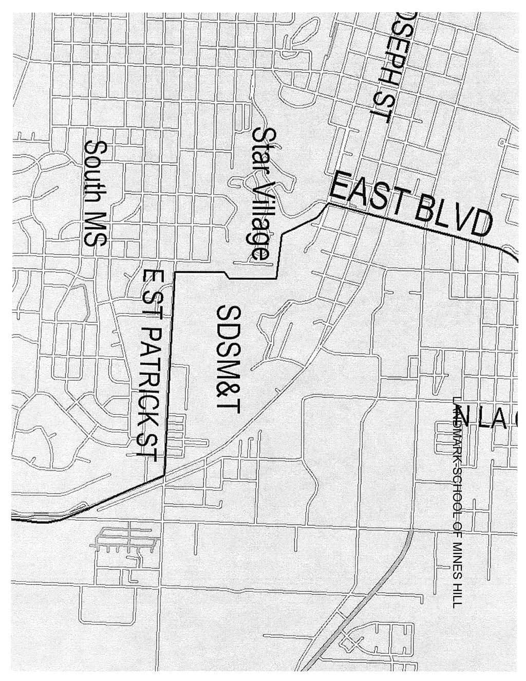
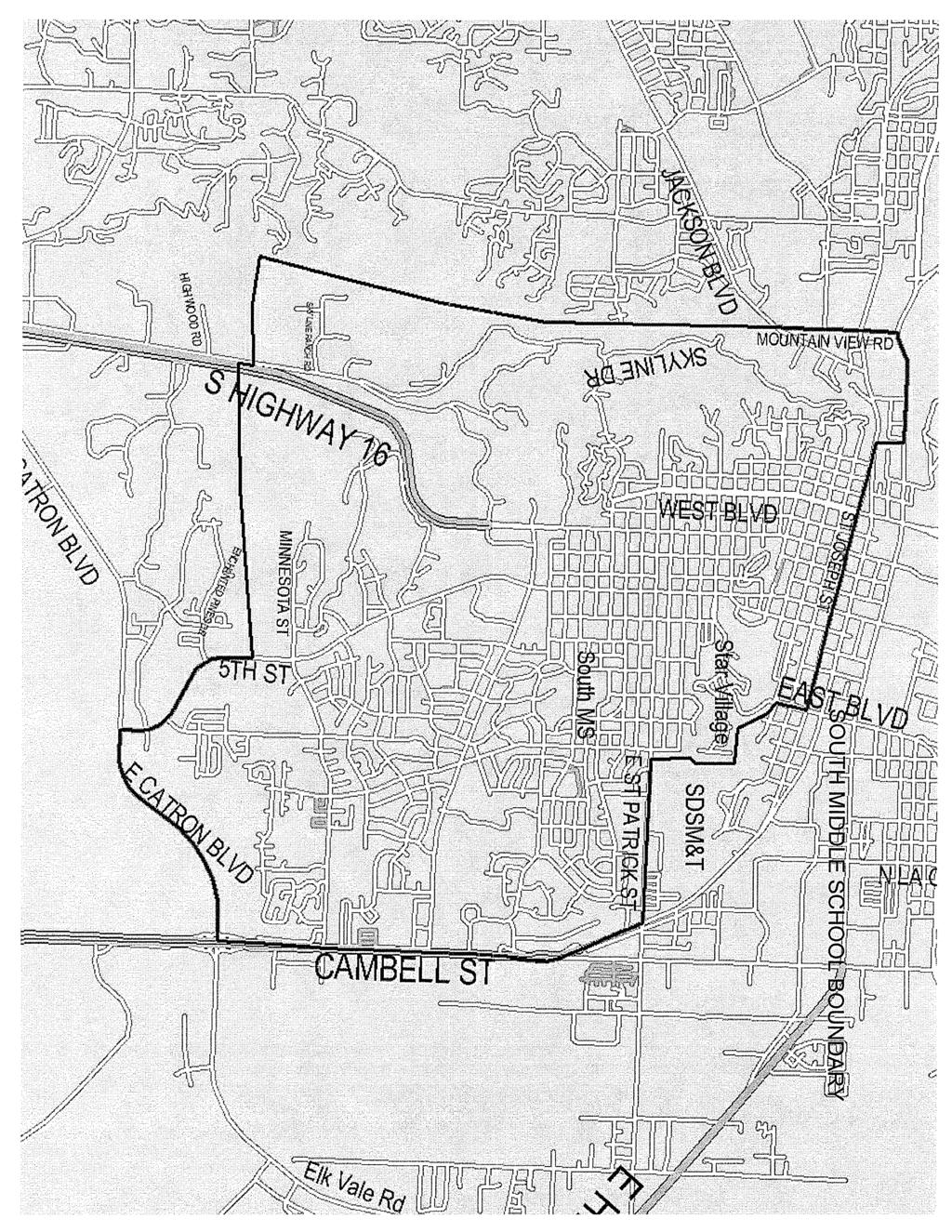
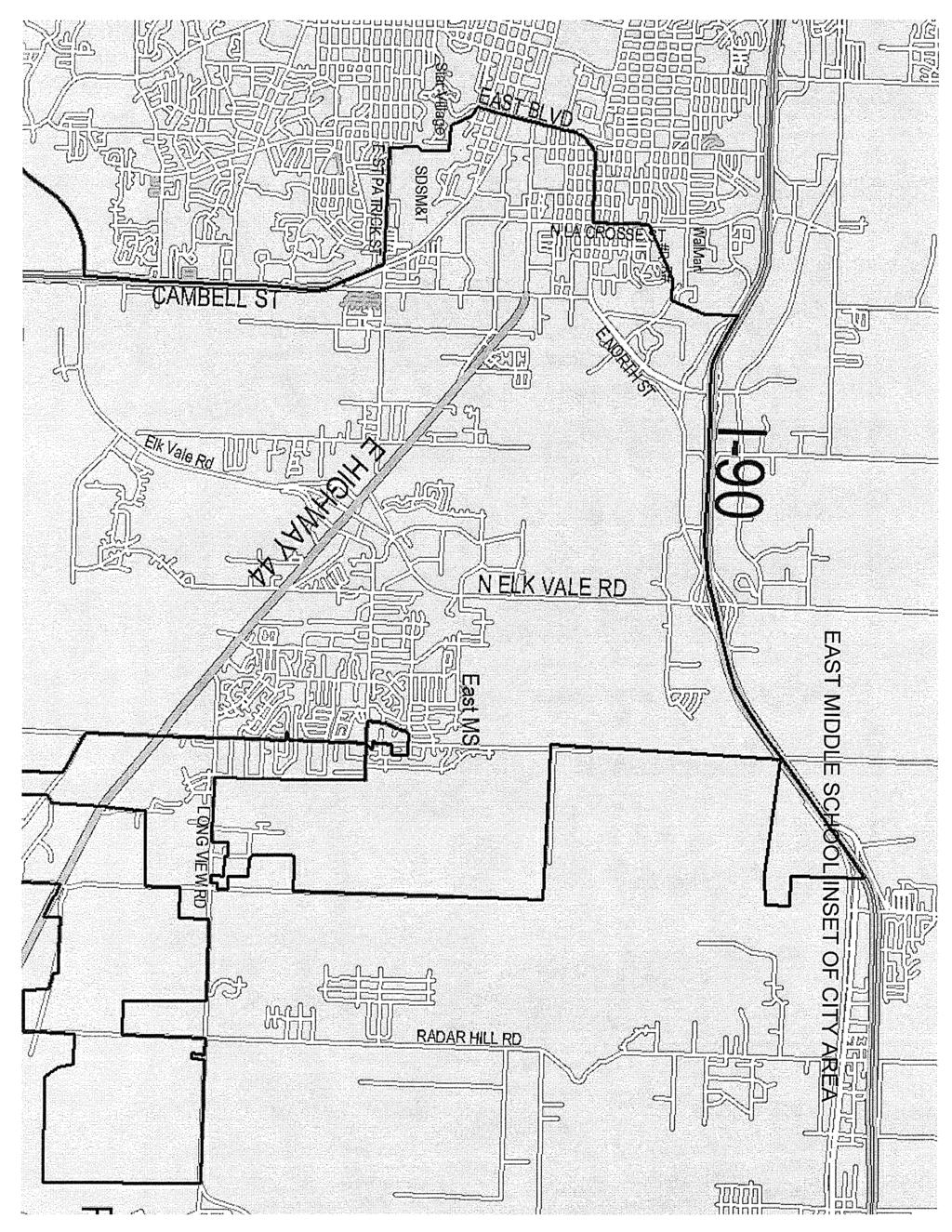
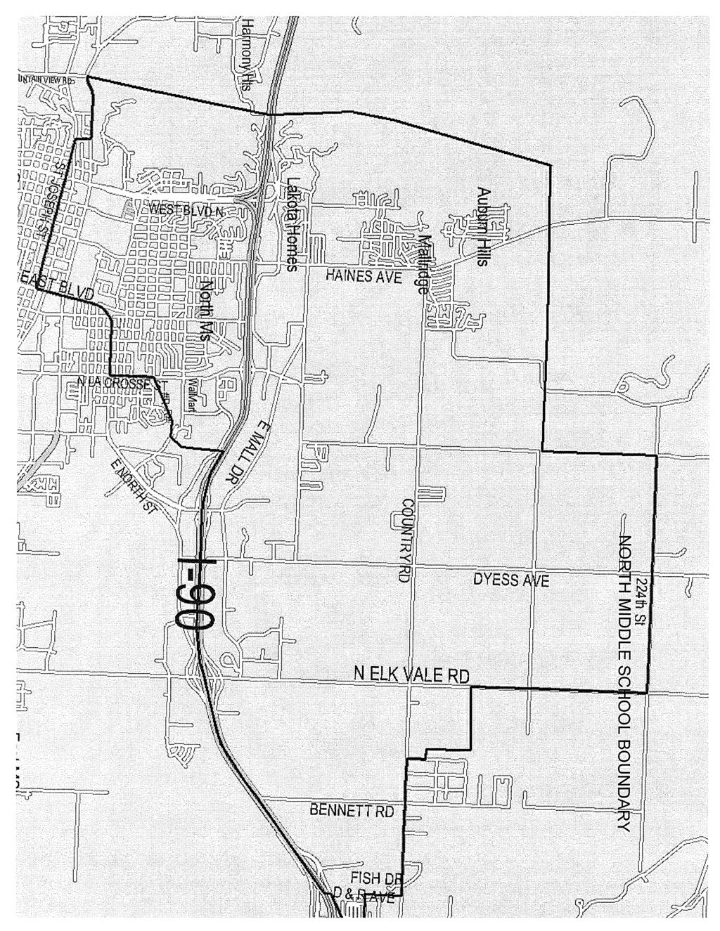
3 ADMINISTRATION CONSIDERATION: Administration recommends the boundary changes as follows: Landmarks referred to as School of Mines Hill - On East St. Patrick Street, west of Robbins Drive and East of Elm Avenue is an area that has no homes. It is behind the school of Mines. The boundary follows an imaginary line north through this area, then it goes west towards the east side of East Boulevard. It is on the east side of Star Village; it then travels northwest to the intersection of Quincy and East Boulevard. (See attached map.) South Middle School Beginning at the Northwest corner of the boundary area at West Omaha and Mountain View Road, the boundary line travels south to Jackson Boulevard. The line continues to travel straight south along the west side of Skyline Drive all the way to a point east of Springbrook Acres. The boundary turns east and crosses Highway 16 at a point north of Enchanted Hills continuing east to 5 th Street. It then follows 5 th Street south to Catron Boulevard, and then turns east toward Highway 79. At Highway 79, it travels north along the west side of Cambell Street following the St. Joseph Street exit to East St. Patrick Street. At that point the boundary goes west and includes the south side of East St. Patrick Street to the landmark referred to as the School of Mines Hill. The boundary line travels through the landmark and at Quincy and East Boulevard it turns north to East Boulevard and St. Joseph Street. It travels west along the south side of East St. Joseph Street to where St. Joseph Street meets West Main Street. It then goes north to West Omaha and follows the south side of West Omaha to where it meets Mountain View Road. (See attached map.) East Middle School Boundary The boundary area follows the district boundary line on the east from I-90 on the north to the southern edge of the Rapid City Area School district boundary, then to the west to and including both sides of Highway 79. It then goes north crossing Spring Creek Road about ½ mile west of where it intersects with Highway 79; it continues north to East Catron Boulevard, then along the east side of Cambell Street following the St. Joseph Street exit to East St. Patrick Street. At that point the boundary goes west and includes the north side of East St. Patrick Street to the landmark referred to as the School of Mines Hill. The boundary line travels through the landmark and at Quincy and East Boulevard, it follows the east side of East Boulevard and south side of East North Street to North LaCrosse Street, then it follows the east side of North LaCrosse Street to the railroad tracks just south of East Van Buren Street. At that point it follows the railroad tracks east to East Anamosa Street and then turns north on the east side of Sunnyside Avenue and continues to the south side of I-90; it then follows the south side of I-90 east to where the Rapid City School District Boundary and the Douglas School District boundary meet. (See attached map.)
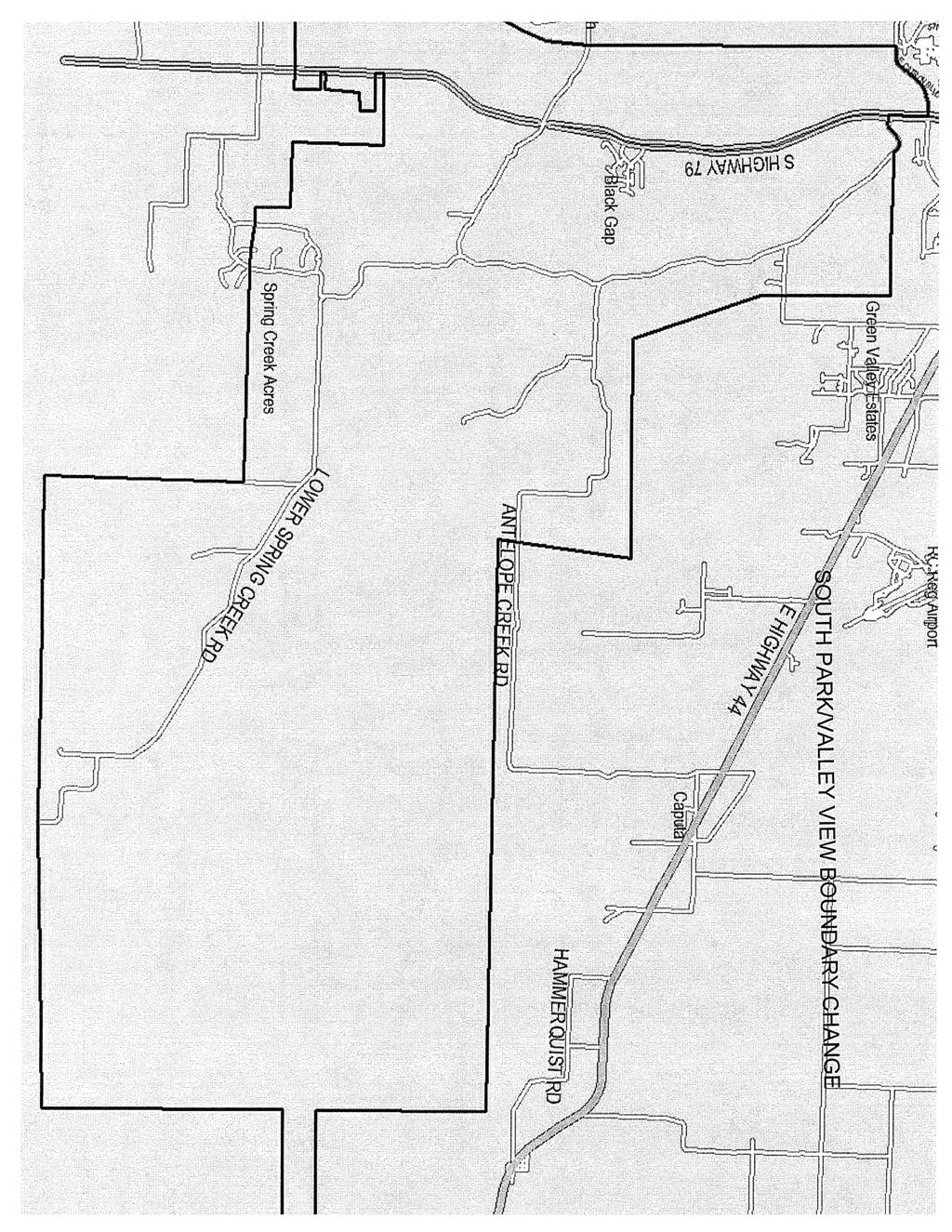
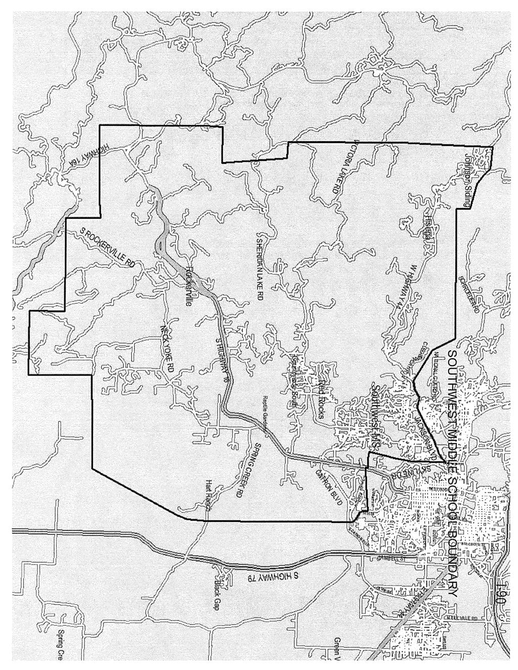
4 South Park/Valley View Boundary Change The following area, previously assigned to South Park will now be in the Valley View attendance area: From the southern edge of the Rapid City School District Boundary the area encompasses the area along the west side of Highway 79, the boundary goes north crossing Spring Creek Road about ½ mile west of where it intersects with Highway 79; it continues north to East Catron Boulevard and then curves toward where Highway 79 connects with Elk Vale Road. The boundary line follows Highway 79 south to Old Folsom Road and goes straight east to a point west of Reservoir Road and then south through Lamb Road, just east of Kimberwick Road. The line stays east of Old Folsom Road and then turns east on the north side of Antelope Creek Road. Following the direction of Antelope Creek Road, the line stays north and east and then turns south to cross Antelope Creek Road at approximately address. It travels straight east to the east edge of the Rapid City District boundary, and then travels west along the south edge of the Rapid City District boundary. (See attached map.) North Middle School The boundary area follows the district boundary line on the north. On the east, from Country Road, it turns south just past Fish Drive. It juts to the east at the 700 block of D & R Avenue and then south again at West Gate Road. It turns southwest at the North I-90 Service Road and joins I-90. It follows I-90 to a point straight north of Eglin Street (approximately 1270 Eglin). It turns to the south and continues to the east of Sunnyside Avenue and then follows the railroad tracks to the southwest to a point on LaCrosse Street just south of East Van Buren. It travels south on the west side of North LaCrosse Street to the north side of East North Street continuing on the west side of East Boulevard and then turning west on the north side of St. Joseph Street to the point where it joins West Main. It then travels north to West Omaha and follows it to Mountain View Road. It continues straight north through the area east of Deadwood Avenue North and east of Harmony Heights. The boundary line continues to the northeast to the point that it joins the district boundary line on the north. (See attached map.) Southwest Middle School Boundary The boundary area follows the district boundary line on the southern edge from west of but not including Highway 79 to the western edge of the school district boundary. It then follows the western edge of the district boundary north to a point between West Highway 44 and Nemo Road on Norris Peak Road. From this point the boundary continues to the southeast through undeveloped areas. It goes south of the Schroeder Road area; then the line continues east towards Rapid City encompassing the area accessible from West Highway 44. At a point between the National Guard Road and Cleghorn Canyon, the boundary travels Southeast to where it meets Jackson Boulevard. The boundary then follows the south side of Jackson Boulevard to the intersection of Mountain View Road, turning south and traveling along the west side of Skyline Drive and encompassing the housing developments accessed from Sheridan Lake Road all
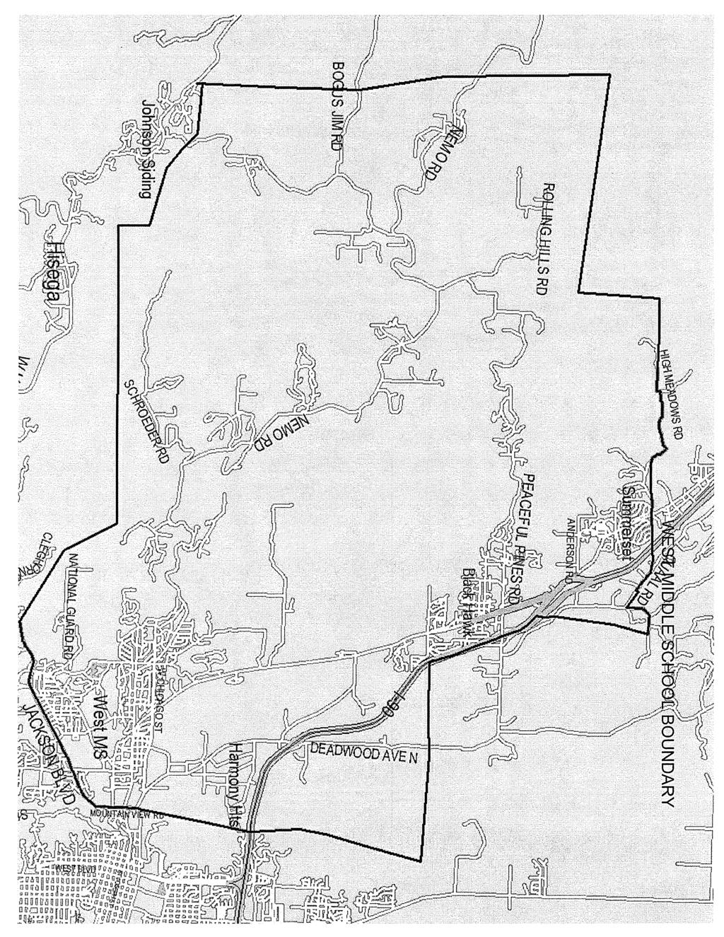
5 the way to a point east of Springbrook Acres. The boundary turns east and crosses Highway 16 at a point north of Enchanted Hills traveling east to 5 th Street. It then follows 5 th Street south to Catron Boulevard and beyond. It adjoins the west boundary of East Middle School along Highway 79. (See attached map.) Stevens/Central High School Boundary Change Students in the new Southwest attendance area along Highway 16 that previously attended Central High School, will now be in the Stevens attendance area. West Middle School At the northwest corner of the Rapid City Area Schools boundary, a point northwest of Rolling Hills Subdivision and north of Nemo Road, the boundary travels south along the school district boundary to a point between West Highway 44 and Nemo Road. It turns east and crosses Norris Peak Road and then travels southeast to encompass Schroeder Road; it travels east towards Rapid City encompassing areas accessible from Nemo Road. At a point between the National Guard Road and Cleghorn Canyon, the boundary travels Southeast to where it meets Jackson Boulevard. It follows the north side of Jackson Boulevard to the west side of Mountain View Road. It continues straight north through West Omaha and beyond through the area east of Deadwood Avenue north to Harmony Heights. It continues north of I-90 to the northern edge of the Rapid City Area School District Boundary. It then turns west and follows the existing northern boundary of the Rapid City Area Schools. (See attached map.) ADMINISTRATION S RECOMMENDATION: It is recommended that the board of education approve the boundary changes, effective at the beginning of the school year, as presented.
6
7

8
9
10
11
12
13
RAPID CITY AREA SCHOOL 51/ th Street Rapid City, SD Assistant Superintendent. Date: October 14, Board of Education, Dr.
 RAPID CITY AREA SCHOOL 51/4 300 6 th Street Rapid City, SD 57701 Assistant Superintendent Student Achievement (605) 394-4037, (605) 394-5147 Fax (605) 394-4062 Date: October 14, 2011 To: From: Cc: Subject:
Springettsbury Township. Road Improvement Projects
 Springettsbury Township Road Improvement Projects 2009 2016 2016 Township Road Improvement Projects Springettsbury Township is divided into the following 4 Sectors: Northwest Sector Sherman Street Route
TRAFALGAR PARK. 78: p.140 W 99th St FLAT ROCK CREEK PARK. W 103rd St OVERLAND PARK. Quivira Rd. College Blvd. Shared use path. Mountain bike trail
 Lenexa: overview TRAFALGAR PARK 78: p.140 As the Westport Route crosses over Lenexa's boundaries with Olathe and Overland Park several times, approximately 2.75 or 3 miles of the historic route of the
O R D I N A N C E NO AN ORDINANCE, amending Section Two of Ordinance No. 1864, adopted April 3, 1969 and revising the boundaries of
 O R D I N A N C E NO. 2032 AN ORDINANCE, amending Section Two of Ordinance No. 1864, adopted April 3, 1969 and revising the boundaries of Subdistrict No. 268 (Lin-Ferry - Tesson Ferry) of The Metropolitan
Rapid City Transit Development Plan. July Prepared for: Rapid City Growth Management Department
 Rapid City 2009-2013 Transit Development Plan July 2008 Prepared for: Rapid City Growth Management Department Rapid City Transit Development Plan 2009-2013 Prepared for: Rapid City Growth Management Department
United States Department of the Interior National Park Service. Boundary Expansion Listed in National Register January 11, 2017
 NPS Form 10900-a (Rev. 8/2002) OMB No. 10240018 United States Department of the Interior National Park Service Boundary Expansion Listed in National Register January 11, 2017 National Register of Historic
RETAIL (ON-OFF SALE) MALT BEVERAGE LICENSE VIDEO LOTTERY UPDATED 9/4/18. Renew Annually: July 1st
 MALT BEVERAGE LICENSE VIDEO LOTTERY UPDATED 9/4/18. Renew Annually: July 1st") Bach Investments, Inc. 1575 N. LaCrosse Street, Ste. D CCKT Inc 316 East Blvd Hideaway Casino 1575 N. LaCrosse Street, Ste. D Queen of Hearts Casino II 316 E. Blvd. Suite 110 RB-2962 RB-2998 CCKT Inc.
Bach Investments, Inc. 1575 N. LaCrosse Street, Ste. D CCKT Inc 316 East Blvd Hideaway Casino 1575 N. LaCrosse Street, Ste. D Queen of Hearts Casino II 316 E. Blvd. Suite 110 RB-2962 RB-2998 CCKT Inc.
RETAIL (ON-OFF SALE) MALT BEVERAGE LICENSE AND VIDEO LOTTERY. Renew Annually: July 1st
 MALT BEVERAGE LICENSE AND VIDEO LOTTERY. Renew Annually: July 1st") RETAIL (ON-OFF SALE) MALT BEVERAGE LICENSE AND VIDEO LOTTERY Renew Annually: July 1st OWNER NAME / Wyngard Pot O Gold Casino Inc. Lucky Ds Casino II 1330 E St Pat St #2 Rapid City, Wyngard Pot O Gold Casino
RETAIL (ON-OFF SALE) MALT BEVERAGE LICENSE AND VIDEO LOTTERY Renew Annually: July 1st OWNER NAME / Wyngard Pot O Gold Casino Inc. Lucky Ds Casino II 1330 E St Pat St #2 Rapid City, Wyngard Pot O Gold Casino
Final Drainage Letter Pikes Peak Community College Downtown Parking Lot Colorado Springs, Colorado
 Final Drainage Letter Pikes Peak Community College Downtown Parking Lot Colorado Springs, Colorado Prepared for: Pikes Peak Community College 5775 South Academy Boulevard Colorado Springs, CO 80906-5422
RETAIL (ON-OFF SALE) MALT BEVERAGE LICENSE and VIDEO LOTTERY. Renew Annually: July 1st
 MALT BEVERAGE LICENSE and VIDEO LOTTERY. Renew Annually: July 1st") 1 Jackpot Casino II 685 "C" LaCrosse Street Rapid City, SD t57701 RB-2986 2 Wyngard Pot O Gold Casino Inc. Lucky Ds Casino II 1330 E St Pat St #2 Wyngard Pot O Gold Casino Inc. Lucky Ds Casino II 1330
1 Jackpot Casino II 685 "C" LaCrosse Street Rapid City, SD t57701 RB-2986 2 Wyngard Pot O Gold Casino Inc. Lucky Ds Casino II 1330 E St Pat St #2 Wyngard Pot O Gold Casino Inc. Lucky Ds Casino II 1330
Retail On-Off Sale Malt Beverage with Video Lottery - Updated 2/22/2018
 Retail On-Off Sale Malt Beverage with Video Lottery - Updated 2/22/2018 OWNER NAME / ADDRESS BUSINESS NAME / ADDRESS CLASS - LICENSE NO. #2-East North Casino 230 East North Street RB-2946 MG Oil Rapid
Napa County Planning Commission Board Agenda Letter
 Agenda Date: 7/20/2011 Agenda Placement: 10A Napa County Planning Commission Board Agenda Letter TO: FROM: Napa County Planning Commission Hillary Gitelman - Director Conservation, Development & Planning
THREE MILE PLAN TOWN OF SUPERIOR COLORADO
 THREE MILE PLAN TOWN OF SUPERIOR COLORADO February 23, 2015 INTRODUCTION This document has been prepared by the Town of Superior, Colorado, to address the existing and proposed land uses within an approximate
APPENDIX IV MINOR HOCKEY ZONES
 221 APPENDIX IV MINOR HOCKEY ZONES To assist in the administration of Hockey Alberta, and to assist in carrying out the objectives of Hockey Alberta, the Province of Alberta will be divided into Zones,
KDOT announces approved November bids
 IMMEDIATE RELEASE Nov. 27, 2018 For more information: Kim Stich 785.296.3585 KDOT announces approved November bids The Kansas Department of Transportation announces approved bids for state highway construction
ORDI NANC E NO
 ORDI NANC E NO. 13622 AN ORDINANCE to amend the Official Zoning Map of the City of Des Moines, Iowa, set forth in Section 2A-5 of the Municipal Code of the City of Des Moines, 1991, by rezoning and changing
Royal Gorge Far Out Trail to Le Point
 Royal Gorge Far Out Trail to Le Point Direction to trailhead: From East Ridge Campground: Drive west from Canon City on US 50 to County Road 3A, the entrance road to the Royal Gorge Park. Turn left onto
Part Three : COMMUNITY PLAN AREAS AND SPECIAL STUDY AREAS SACRAMENTO 2030 GENERAL PLAN. Introduction
 Special study Areas Part Three : COMMUNITY PLAN AREAS AND SPECIAL STUDY AREAS SACRAMENTO 2030 GENERAL PLAN Introduction Beyond the boundaries of the 2030 General Plan, the City has defined Special Study
IN THE CHANCERY COURT OF LAMAR COUNTY, MISSISSIPPI CIVIL ACTION NO.: CITY OF HATTIESBURG, MISSISSIPPI
 IN THE CHANCERY COURT OF LAMAR COUNTY, MISSISSIPPI IN THE MATTER OF THE INCORPORATION OF THE CITY OF BELLEVUE, MISSISSIPPI, BELLEVUE INCORPORATORS VS. CITY OF HATTIESBURG, MISSISSIPPI PETITIONERS CIVIL
BUTCHER CREEK RANCH. Butcher Creek Ranch. Roscoe, Montana. Reduced to $1,650,000.
 BUTCHER CREEK RANCH Butcher Creek Ranch Roscoe, Montana Reduced to $1,650,000. Offered Exclusively By: Sonny Todd Real Estate 301 West First Avenue, PO Box 788 Big Timber, Montana 59011 Office: (406) 932-1031
Great Falls Public Schools, MT Options Analysis
 Great Falls Public Schools, MT Options Analysis Revised: 02/06/2018 Elementary Enrollment/Live-In Statistics The following table shows how many 2017-18 K-6 th students are enrolled at each Elementary School,
RE: Request for de-annexation of Harney Peak Ranch lands from the City of Rapid City
 14AN002 September 2, 2014 Harney Peak Ranch Mr. David Lamb and Ms. Andrea Andersen, owner/operators 4555 Reservoir Road Rapid City, SD 57703 City of Rapid City City Council Planning Commission RE: Request
Centennial Airport Flight school practice areas. A PowerPoint Presentation By Michael Shannon Chief Flight Instructor Aspen Flying Club
 Centennial Airport Flight school practice areas A PowerPoint Presentation By Michael Shannon Chief Flight Instructor Aspen Flying Club The Denver metro area airspace is very complex and congested. Centennial
MAY 17, :00 P.M.
 MOBILE CITY PLANNING COMMISSION AGENDA MAY 17, 2018-2:00 P.M. AUDITORIUM, MOBILE GOVERNMENT PLAZA ROLL CALL: Mr. Carlos Gant, Chairman Ms. Libba Latham (PJ), Vice Chairman Ms. Jennifer Denson, Secretary
1.2 Corridor History and Current Characteristics
 SECTION 1 Description and Background of Study Area 1.1 Introduction This preliminary engineering report was prepared for the Alaska Department of Transportation and Public Facilities (ADOT&PF). It is part
Honeywell Certified Installer Training Program. Training Facilities and Certification Policy
 Honeywell Certified Installer Training Program Training Facilities and Certification Policy Revised March 2018 Page 1 Honeywell Certified Installer Training Program When preparing to attend training please
ORDINANCE NO. 612, DESCRIPTION ATTACHED
 Insert BOARD OF TRUSTEES, TOWN or PAGOSA SPRINGS STATE OF COLORADO ORDINANCE NO. 612, AMENDING ORDINANCE NO. 561, ESTABLISHING THE TOWN OF PAGOSA SPRINGS SANITATION ENERAL IMPROVEMENT DISTRICT, TO CLARIFY
2014 NOTAM Special Flight Procedures. Indianapolis, IN Effective 0600 EDST (Local) May 30, 2014 Until 2000 EDST (Local) May 31, 2014
 May 30, 2014 Until 2000 EDST (Local) May 31, 2014") 2014 NOTAM Special Flight Procedures Indianapolis, IN Effective 0600 EDST (Local) May 30, 2014 Until 2000 EDST (Local) May 31, 2014 AIRCRAFT OWNERS AND PILOTS ASSOCIATION (AOPA) FLY-IN INDIANAPOLIS, IN
2014 NOTAM Special Flight Procedures Indianapolis, IN Effective 0600 EDST (Local) May 30, 2014 Until 2000 EDST (Local) May 31, 2014 AIRCRAFT OWNERS AND PILOTS ASSOCIATION (AOPA) FLY-IN INDIANAPOLIS, IN
Sale Price: $650,000. Arlyn Dyce Broker Associate
 RETAIL FOR SALE 2223 Jackson Boulevard, Rapid City, SD 57702 STATE ST Updated April 2018 MOU BU MOUNTAIN VIEW RD Sale Price: $650,000 Highlights Rare opportunity for one of the best, most visible corners
Silver Center Development USA Parkway & Highway 50 Silver Springs, Nevada
 O f f e r i n g M e m o r a n d u m Silver Center Development USA Parkway & Highway 50 Silver Springs, Nevada 25.7 Acres presented exclusively by Ron Cobb Principal Direct: (775) 329-4000 x103 Cell: (775)
Tinker Air Force Base, Oklahoma
 Table 5.4 Generalized Zoning within the Tinker AFB Clear Zones and Accident Potential Zones (Off-Installation) Category Acreage Residential 1,486 Commercial 191 Industrial 128 Public/Quasi-public 0 Recreational/Open/Agricultural/Low
Attachment D: PHOTO LOG CITY OF ARCATA RAIL-WITH-TRAIL CONNECTIVITY PROJECT
 01051-09004 Attachment D: PHOTO LOG CITY OF ARCATA RAIL-WITH-TRAIL CONNECTIVITY PROJECT DRAFT: June 30, 2010 Applicant: City of Arcata 736 F Street Arcata, CA 95521 Phone (707) 825-2154 Prepared by: Winzler
The north half of Section 18, Township 37 North, Range 6 East, Second Principal Meridian, Jefferson Township, Elkhart County, Indiana; also,
 The north half of Section 18, Township 37 North, Range 6 East, Second Principal Meridian, Jefferson Township, Elkhart County, Indiana; also, The east half of Sections 21, 28, and 33, Township 37 North,
Portable Noise Monitor Report
 Portable Noise Monitor Report Chicago O Hare International Airport Site 299 93 Wilshire Avenue, Elk Grove Village June 27, 217 through July 1, 217 USH8-ILH55-ILS28 Visit the O Hare Noise webpage on the
BY-LAW NO TO DIVIDE THE TOWN S TERRITORY INTO SIX ELECTORAL DISTRICTS
 BY-LAW NO. TO DIVIDE THE TOWN S TERRITORY INTO SIX ELECTORAL DISTRICTS ADOPTION PROCEDURE SUMMARY NOTICE OF MOTION: MARCH 21, 2016 ADOPTION OF BY-LAW: MAY 16, 2016 COMING INTO EFFECT: OCTOBER 31, 2016
ALTA/ACSM LAND TITLE SURVEY Parts of Augusta Heights, First Section (Plat Book 20, Page 5), Augusta Heights, Second Section (Plat Book 19, Page 25),
, Augusta Heights, Second Section (Plat Book 19, Page 25),") ALTA/ACSM LAND TITLE SURVEY Parts of Augusta Heights, First Section (Plat Book 20, Page 5), Augusta Heights, Second Section (Plat Book 19, Page 25), and Augusta Park, 3rd Section (Plat Book 24, Page 132)
ALTA/ACSM LAND TITLE SURVEY Parts of Augusta Heights, First Section (Plat Book 20, Page 5), Augusta Heights, Second Section (Plat Book 19, Page 25), and Augusta Park, 3rd Section (Plat Book 24, Page 132)
ELKHORN PUBLIC SCHOOLS January District Growth and Facility Needs
 ELKHORN PUBLIC SCHOOLS January 2018 District Growth and Facility Needs New Schools Summary of Bond Resolution High School Middle School Elementary School Existing Facilities Land Acquisition $149,615,000
SPECIAL USE PERMIT - SUP Blue Valley Parkway
 NOTICE OF PUBLIC HEARING CITY PLANNING COMMISSION CITY OF OVERLAND PARK, KANSAS Notice is hereby given that the City Planning Commission of Overland Park, Kansas, will hold a public hearing Monday, April
ORDINANCE NO. 510 THEREFORE, BE IT ORDAINED BY THE GOVERNING BODY OF THE CITY OF BEL AIRE, KANSAS:
 (Published in The Ark Valley News on July, 2012.) ORDINANCE NO. 510 S-I-1 GILMORE & BELL, P.C. 07/11/2012 AN ORDINANCE CREATING A COMMUNITY IMPROVEMENT DISTRICT IN THE CITY OF BEL AIRE, KANSAS; AUTHORIZING
Figure 1: Little Dry Creek Trail Crossing
 Figure 1: Little Dry Creek Trail Crossing Figure 2: Little Dry Creek Trail Crossing Northwest Rail Environmental Evaluation Temporary Trail Detour Concurrence Form Adams County, Little Dry Creek Trail
RETAIL (ON-OFF SALE) MALT BEVERAGE LICENSE WITHOUT VIDEO LOTTERY. Renew Annually: July 1st
 MALT BEVERAGE LICENSE WITHOUT VIDEO LOTTERY. Renew Annually: July 1st") Justin Christman 919 Main ST #13 Matthew Sullivan PO Box 723 Cortez LLC 502 W Blvd Rapid 168 Inc 1900 N Maple Ave OWNER NAME / ADDRESS Black Hills Amateur Baseball Inc. c/o John Sayles 2610 Lawndale Dr.,
Justin Christman 919 Main ST #13 Matthew Sullivan PO Box 723 Cortez LLC 502 W Blvd Rapid 168 Inc 1900 N Maple Ave OWNER NAME / ADDRESS Black Hills Amateur Baseball Inc. c/o John Sayles 2610 Lawndale Dr.,
TIMS & PowerSchool 2/3/2016. TIMS and PowerSchool. Session Overview
 TIMS and PowerSchool TIMS & PowerSchool Kevin R. Hart TIMS and PowerSchool Kevin R. Hart TIMS Project Leader UNC Charlotte Urban Institute Session Overview What is TIMS? PowerSchool Data in TIMS PowerSchool
Albany. Corvallis Florence Green Trees. Philomath Florence Town Hayden Bridge Halsey McKenzie Valley
 Newport Newport Waldport Yachats See Florence/ Dunes City Map Toledo Lincoln County 230 Albany 225 - Florence Coast Village 234 - Pleasant Hill/Oakridge Corvallis 226 - Florence Green Trees Linn County
IOWA ORNITHOLOGISTS' UNION - Birding Sites in Linn County
 IOWA ORNITHOLOGISTS' UNION - Birding Sites in Linn County Printed on 6/15/2018 Bever Park (ebird Hotspot) GPS Coordinates: 41.9851219,-91.6269125 Restrooms Parking Trails ADA Accessible Trails Boyson Trail
Site Location and Setting
 Memorandum Date: To: From: Subject: Kristy Le, Gary Black Steve Orem Santa Teresa County Park Historic Area Traffic and Parking Study Hexagon Transportation Consultants, Inc. has completed a traffic and
Fee:$O.OO P DAWSON CTY, MT Rec/Filed 1
 462708 Fee:$O.OO P DAWSON CTY, MT Rec/Filed 1 Shirley Kreiman, Clk & Rcdr By..; I ~::::!o:::!::::~~!..!:!~~~~ RETURN TO: FILED RESOLUTION 2017-33 RESOLUTION OF INTENTION TO CREATE RURAL SPECIAL IMPROVEMENT
UMASS CROSS-COUNTRY Trails
 UMASS CROSS-COUNTRY Trails 1) EGG (43 min) (A) From Cage proceed to North Pleasant street (by campus pond). Make left and head toward LGRT and pass School of Education. Pass Puffton Apt complex (on left)
SEPTEMBER 6, :00 P.M.
 MOBILE CITY PLANNING COMMISSION AGENDA SEPTEMBER 6, 2018-2:00 P.M. AUDITORIUM, MOBILE GOVERNMENT PLAZA ROLL CALL: Mr. Carlos Gant, Chairman Ms. Libba Latham (PJ), Vice Chairman Ms. Jennifer Denson, Secretary
APPLICANTS PROPOSED TOUR SCHEDULE & PROTOCOL
 APPLICANTS PROPOSED TOUR SCHEDULE & PROTOCOL Pursuant to Paragraph 18 of the Procedural Order issued by the Chairman of the Power Plant and Transmission Line Siting Committee (the Committee ) on August
No. PW ASSESSMENT ROLL FOR BLOCK ALLEY PAVING (FLORMANN/SUNNYSIDE ADDITION) PROJECT NO. ST
 PROJECT NO. ST") ASSESSMENT ROLL FOR BLOCK 31-32 ALLEY PAVING (FLORMANN/SUNNYSIDE ADDITION) PROJECT NO. ST02-1233 HONORABLE MAYOR AND CITY COUNCIL: Submitted herein is the Assessment Role of the costs for the Block 31-23
ASSESSMENT ROLL FOR BLOCK 31-32 ALLEY PAVING (FLORMANN/SUNNYSIDE ADDITION) PROJECT NO. ST02-1233 HONORABLE MAYOR AND CITY COUNCIL: Submitted herein is the Assessment Role of the costs for the Block 31-23
Great Development Opportunity
 Great Development Opportunity NW Corner I-94 / 66th St. 3238 66th St. NE $2,600,000 - Approx. 40 Acres Proposed Interchange 80th St 66th St. 66th St. to Lincoln Future Residential New Multi-Family Development
CITY OF SNOHOMISH Snohomish, Washington ORDINANCE 2019 AN ORDINANCE OF THE CITY OF SNOHOMISH, WASHINGTON ESTABLISHING A NEW LAND USE DESIGNATION MAP.
 OF SNOHOMISH Snohomish, Washington ORDINANCE 2019 AN ORDINANCE OF THE OF SNOHOMISH, WASHINGTON EABLISHING A NEW LAND USE DESIGNATION MAP. WHEREAS, the City Council considers long-range planning as embodied
National Transportation Safety Board Recommendation and FAA Air Traffic Orders
 Page 1 of 8 MEMORANDUM TO: Planning, Development and Environment Committee FROM: Chad E. Leqve, Director Environment (725.6326) SUBJECT: NOISE OVERSIGHT COMMITTEE (NOC) CONVERGING RUNWAY OPERATION (CRO)
Sevierville, Tennessee
 Interstate 40 at Exit 407 Sevierville, Tennessee Type Open Air Center with entertainment and mixed use components (retail, hotel & restaurant) Location Interstate 40 and Exit 407 (Snyder Road) Owner, LLC
SANTA FE. 82: p.108 POLLINATOR PRAIRIE PARK. 86: p : p : p.113. ARROWHEAD PARK 151st St. 41: p.102. Indian Creek Greenway PARK
 Santa Fe, Oregon, and California ational Historic Trails Olathe: overview W 135th St W 143rd St GARDER 91: p.117 SATA FE UICORPORATED JOHSO COUTY W Santa Fe St ELM GROVE CAMPGROUD OREGO TRAIL W Dennis
LIBERTY CATS 2014 TICA ANNUAL. Thank you for entering the 2014 TICA Annual show, brought to you by Liberty Cats!
 LIBERTY CATS 2014 TICA ANNUAL TRAVEL GUIDE Thank you for entering the 2014 TICA Annual show, brought to you by Liberty Cats! This travel guide will help you get around while visiting Massachusetts and
Treaty Oaks Ranch 323+/- Acres Hood County, Texas $1,776,500
 Bret Polk Mobile: (254) 965-0349 Office: (214) 361-9191 Treaty Oaks Ranch 323+/- Acres Hood County, Texas $1,776,500 LOCATION: The ranch is located in a desirable area 10+/- miles south of Granbury, Texas,
playwinterpark.com Off The Beaten Path Hikes Hiking Recommendations for the Adventurous Hiker
 playwinterpark.com Off The Beaten Path Hikes Hiking Recommendations for the Adventurous Hiker Hike: Devil s Thumb (difficult) Length: 3.93 miles one-way Elevation: Trailhead 9609 Destination 12,236 Trailhead
PROPOSED ALTERATION AND EXPANSION OF THE MOUNT PEARL MUNICIPAL BOUNDARY TO INCLUDE THE AREA OF THE FORMER PEARL ESTATE LANDS & ENVIRONS
 PROPOSED ALTERATION AND EXPANSION OF THE MOUNT PEARL MUNICIPAL BOUNDARY TO INCLUDE THE AREA OF THE FORMER PEARL ESTATE LANDS & ENVIRONS JANUARY 4, 2007 INTRODUCTION In accordance with Sections 3 to 6 inclusive
DECEMBER 6, :00 P.M.
 MOBILE CITY PLANNING COMMISSION AGENDA DECEMBER 6, 2018-2:00 P.M. AUDITORIUM, MOBILE GOVERNMENT PLAZA ROLL CALL: Mr. Carlos Gant, Chairman Ms. Libba Latham (PJ), Vice Chairman Ms. Jennifer Denson, Secretary
Appendix I: Wetlands and Vernal Pools Functions and Values
 Appendix I: Wetlands and Vernal Pools Functions and Values Wetlands proposed to be impacted by each alternative were reviewed to determine what functions and values the wetland currently provides that
The following policy has been developed to help members safely fly the backcountry. BACKCOUNTRY FLYING PRIVILEGES:
 T - C R A F T A E R O C L U B B A C K C O U N T R Y F L Y I N G P O L I C Y PURPOSE: Flying in the Idaho and Northwest Backcountry provides a unique opportunity to access some of the world s most spectacular
April 10, Mark Stiles San Juan Public Lands Center Manager 15 Burnett Court Durango, CO Dear Mark,
 Mark Stiles San Juan Public Lands Center Manager 15 Burnett Court Durango, CO 81301 Dear Mark, We are pleased to offer the following comments on the draft San Juan Public Lands Center management plans
AVAILABLE (RETAIL / OFFICE / INDUSTRIAL / RESIDENTIAL) NY ROUTE N.Y. THRUWAY, EXIT 16 Villages of Harriman & Woodbury, Orange County, NY
 NY ROUTE N.Y. THRUWAY, EXIT 16 Villages of Harriman & Woodbury, Orange County, NY") NY ROUTE 17 AVAILABLE ±130 ACRE MIXED-USE DEVELOPMENT SITE (RETAIL / OFFICE / INDUSTRIAL / RESIDENTIAL) NY ROUTE 17 @ N.Y. THRUWAY, EXIT 16 Villages of Harriman & Woodbury, Orange County, NY WOODBURY COMMONS
NY ROUTE 17 AVAILABLE ±130 ACRE MIXED-USE DEVELOPMENT SITE (RETAIL / OFFICE / INDUSTRIAL / RESIDENTIAL) NY ROUTE 17 @ N.Y. THRUWAY, EXIT 16 Villages of Harriman & Woodbury, Orange County, NY WOODBURY COMMONS
CITY OF PALMDALE. REPORT to the Mayor and Members of the City Council from the City Manager
 CITY OF PALMDALE REPORT to the Mayor and Members of the City Council from the City Manager DATE: June 4, 2014 SUBJECT: Specific Plan Amendment 14-01; Amending the Use Designation of 23.97 Acres within
SERVICE AREA BOUNDARIES Beginning SFY2018
 SERVICE AREA BOUNDARIES Beginning SFY2018 Service Area A (1) Boundaries -- all of Ray County Ray County Fellowship Senior Center 1015 West Royle Richmond, Missouri 64085 Service Area B Beginning at I-435
SPECIAL USE PERMIT - SUP West 159th Street. SBMS cell site 4459, Lot 1, a subdivision in Overland Park, Johnson County, Kansas.
 NOTICE OF PUBLIC HEARING CITY PLANNING COMMISSION CITY OF OVERLAND PARK, KANSAS Notice is hereby given that the City Planning Commission of Overland Park, Kansas, will hold a public hearing Monday, May
OKLAHOMA'S HISTORIC ROUTE 66 AUDIO TOUR
 OKLAHOMA'S HISTORIC ROUTE 66 AUDIO TOUR Oklahoma s Historic Route 66 Audio Tour, created by the Oklahoma Historical Society, is an informative online audio tour that showcases the state's heritage and
ST. CLOUD LAKE WOBEGON TRAIL OPEN HOUSE
 ST. CLOUD LAKE WOBEGON TRAIL OPEN HOUSE PROJECT INTRODUCTION Project partners: St. Cloud Area Planning Organiza on (APO) and the City of St. Cloud. The project area is approximately 2.5 miles long, extending
1 The Cadastral Mapping Fee Order (AR 94/2000) is amended by this Regulation.
 is amended by this Regulation.") Alberta Regulation 21/2005 Surveys Act CADASTRAL MAPPING FEE AMENDMENT ORDER Filed: March 2, 2005 For information only: Made by the Minister of Sustainable Resource Development (M.O. 03/2005) on February
Alberta Regulation 21/2005 Surveys Act CADASTRAL MAPPING FEE AMENDMENT ORDER Filed: March 2, 2005 For information only: Made by the Minister of Sustainable Resource Development (M.O. 03/2005) on February
Topographic Maps. Background Sheet
 Topographic Maps History: Background heet The Articles of Confederation (1777) was ratified when western lands were yielded to the Federal Government. This yielding of land gave the Federal Government
CPW Extended Office Hours - Big Game Rifle Seasons October 13, November 18, 2018
 WILDLIFE OFFICES DATES/HOURS EXCEPTIONS BRUSH OFFICE 28167 CoRd T Brush, CO 80723 (970) 842-6300 COLORADO SPRINGS SOUTHEAST REGIONAL OFFICE 4255 Sinton Road Colorado Springs, CO 80907 (719) 227-5200 Closed
Metropolitan Parks and Open Space Commission Subject District(s), Member(s): Policy/Legal Reference: Staff Prepared/Presented: Division/Department:
, Member(s): Policy/Legal Reference: Staff Prepared/Presented: Division/Department:") Business Item Metropolitan Parks and Open Space Commission Meeting date: May 20, 2013 Subject: Proposed System Addition Discussion for the 2040 Regional Parks Policy Plan District(s), Member(s): All Policy/Legal
Business Item Metropolitan Parks and Open Space Commission Meeting date: May 20, 2013 Subject: Proposed System Addition Discussion for the 2040 Regional Parks Policy Plan District(s), Member(s): All Policy/Legal
BE IT ORDAINED by the Mayor and the City Council of the City of Papillion as follows:
 ORDINANCE NO. 1798 AN ORDINANCE TO AMEND CHAPTER 24, SECTION 1 DELINEATING THE VOTING BOUNDARY WARDS FOR THE CITY OF PAPILLION; TO REPEAL THE EXISTING CHAPTER 24, SECTION 1; AND TO PROVIDE FOR AN EFFECTIVE
MOBILE CITY PLANNING COMMISSION AGENDA JULY 16, :00 P.M. AUDITORIUM, MOBILE GOVERNMENT PLAZA
 PAGE 1 MOBILE CITY PLANNING COMMISSION AGENDA - 2:00 P.M. AUDITORIUM, MOBILE GOVERNMENT PLAZA APPROVAL OF MINUTES: HOLDOVERS: June 19, 2008 and July 10, 2008 meetings. 1. Case #ZON2009-01303 William Youngblood
TORONTO TRANSIT COMMISSION REPORT NO.
 Revised: March/13 TORONTO TRANSIT COMMISSION REPORT NO. MEETING DATE: November 18, 2013 SUBJECT: YONGE-EGLINTON AND EGLINTON WEST INTERCHANGE STATIONS METROLINX EGLINTON CROSSTOWN LIGHT RAIL TRANSIT PROJECT
Redevelopment Site 3933 Main Street Dallas, TX FOR SALE Property Overview List Price Land Size Building Size Mark O Briant Tonia Stevens
 Property Overview List Price $1,625,000 Land Size Building Size ±.10,000SF ±1,584 SF Mark O Briant 972.419.4081 obriant@henrysmiller.com Tonia Stevens 972.386.1460 tstevens@henrysmiller.com FOR SALE Demographics
ATTACHMENT B. Reference No.
 ATTACHMENT B Projects in the Five-Year Capital Improvement Program for Fiscal Years Ending 2014-2018 GOVERNMENT CODE SECTION 65402 GENERAL PLAN CONFORMITY ANALYSIS 1 4 Orcutt GS Station 21 (Orcutt) Rebuild
DECEMBER 15, :00 P.M.
 MOBILE CITY PLANNING COMMISSION AGENDA DECEMBER 15, 2016-2:00 P.M. AUDITORIUM, MOBILE GOVERNMENT PLAZA ROLL CALL Mr. Carlos Gant, Chairman Ms. Libba Latham (PJ), Vice Chairman Ms. Jennifer Denson, Secretary
MOBILE CITY PLANNING COMMISSION AGENDA OCTOBER 4, :00 P.M. AUDITORIUM, MOBILE GOVERNMENT PLAZA
 PAGE 1 MOBILE CITY PLANNING COMMISSION AGENDA - 2:00 P.M. AUDITORIUM, MOBILE GOVERNMENT PLAZA APPROVAL OF MINUTES: HOLDOVERS: 1. Case #SUB2007-00208 (Subdivision) Riverwood Cove Subdivision 5620 Gulf Creek
TABLE OF CONTENTS. Coral Springs Charter High School and Middle School Job No Page 2
 Job No. 15-019 Page 2 TABLE OF CONTENTS 1.0 INTRODUCTION... 4 2.0 EXISTING CONDITIONS... 5 3.0 TRAFFIC GENERATION... 7 4.0 TRIP DISTRIBUTION... 8 5.0 FUTURE CONDITIONS... 8 6.0 SITE ACCESS...13 7.0 CONCLUSION...13
Hazardous Materials Technical Report Oregon Department of Transportation. Appendix B. Field Survey Photo Log
 Report Oregon Department of Transportation Appendix B. Field Survey Photo Log No. 1 7/25/17 Southwest View of Site 18, Sherwin- Williams (30 NE Broadway), along NE Victoria Avenue. This building is proposed
C E N T R A L C A T S K I L L S
 120 C E N T R A L C A T S K I L L S Central Catskills Once out of the southern parts of the Catskills, the Long Path enters the more well traveled and civilized regions. The trail joins the Devil s Path,
General Highway System SHEET 1 HILTON HEAD ISLAND URBAN AREA
 5 6 7 8 A A B B General Highway System SHEET 1 HILTON HEAD ISLAND URBAN AREA SECONDARY ROUTE - - - - - 9 WETLAND OR MARSH - - - - - - - - - CHURCH AND CEMETERY - - - - - - - - CEMETERY - - - - - LM 78
KDOT announces approved March bids
 IMMEDIATE RELEASE April 10, 2018 For more information: Kim Stich 785.296.3585 KDOT announces approved March bids The Kansas Department of Transportation announces approved bids for state highway construction
NOTAM. Aircraft Owners and Pilots Association (AOPA) Fly-In Colorado Springs Airport (COS) Colorado Springs, CO SPECIAL FLIGHT PROCEDURES
 Fly-In Colorado Springs Airport (COS) Colorado Springs, CO SPECIAL FLIGHT PROCEDURES") NOTAM Aircraft Owners and Pilots Association (AOPA) Fly-In Colorado Springs Airport (COS) Colorado Springs, CO SPECIAL FLIGHT PROCEDURES EFFECTIVE 12:00 Noon Local Friday, September 25, 2015 Until 6:00
NOTAM Aircraft Owners and Pilots Association (AOPA) Fly-In Colorado Springs Airport (COS) Colorado Springs, CO SPECIAL FLIGHT PROCEDURES EFFECTIVE 12:00 Noon Local Friday, September 25, 2015 Until 6:00
4.0 FACILITIES INVENTORY
 4.0 FACILITIES INVENTORY 4.1 PARK LEVEL OF SERVICE STANDARDS (LOS) Based on current City of Longview Parks and Recreation Level of Service (LOS) Standards (Figure G), the City currently has a deficiency
ADOPTED REGULATION OF THE BOARD OF WILDLIFE COMMISSIONERS. LCB File No. R Effective October 26, 2011
 ADOPTED REGULATION OF THE BOARD OF WILDLIFE COMMISSIONERS LCB File No. R002-11 Effective October 26, 2011 EXPLANATION Matter in italics is new; matter in brackets [omitted material] is material to be omitted.
CHAPTER 1 INTRODUCTION MORENO VALLEY GENERAL PLAN 1. INTRODUCTION. 1.1 What is a General Plan?
 1. INTRODUCTION 1.1 What is a General Plan? A General Plan is a comprehensive long-term strategy for the physical development of a city. It determines how land may be used and the infrastructure and public
FISCHLER PROPERTY COMPANY LLC 1605 HENDRY STREET FORT MYERS, FL
 FISCHLER PROPERTY COMPANY LLC 1605 HENDRY STREET FORT MYERS, FL 33901 WWW.FISCHLERCO.COM FOR SALE 1013 EMBERS PKWY., CAPE CORAL, FL 33993 ENTITLED LAND FOR DEVELOPMENT EMBERS LAKE ESTATES for information
Welcome to Natural Bridge
 Welcome to Natural Bridge Richard R. Randolph IV www.r4capital.com Www.r4land.com 205-879-5517 Work 205-413-8805 Fax 6 Carla Circle Birmingham, AL 35213 rich@r4capital.com Introduction NATURAL BRIDGE 160
MESA COUNTY DEPARTMENT OF PUBLIC WORKS Administration - Building - Engineering Road and Bridge Traffic - Planning - Solid Waste Management
 MESA COUNTY DEPARTMENT OF PUBLIC WORKS Administration - Building - Engineering Road and Bridge Traffic - Planning - Solid Waste Management 200 S. Spruce St. P.O. Box 20,000 Grand Junction, Colorado 81502-5022
GREENSBORO-JAMESTOWN JOINT ANNEXATION AGREEMENT
 NORTH CAROLINA GUILFORD COUNTY GREENSBORO-JAMESTOWN JOINT ANNEXATION AGREEMENT THIS AGREEMENT, made and entered into this the day of, 2011 by and between the City of Greensboro and the Town of Jamestown.
MOBILE CITY PLANNING COMMISSION AGENDA DECEMBER 3, :00 P.M. AUDITORIUM, MOBILE GOVERNMENT PLAZA
 MOBILE CITY AGENDA DECEMBER 3, 2015-2:00 P.M. AUDITORIUM, MOBILE GOVERNMENT PLAZA ROLL CALL: Mr. James (Jay) F. Watkins, Chair Mr. Carlos Gant, Vice Chair Mr. John Vallas Mr. Thomas Doyle Ms. Shirley Sessions
Portable Noise Monitor Report
 Portable Noise Monitor Report Chicago O Hare International Airport Site 241 61 Grange Road, Elk Grove Village October 3, 215 through October 19, 215 USH8-ILH55-ILS28 Visit the O Hare Noise webpage on the
DanielCompanies.com. 80th St. 66th St. to Lincoln. 66th St. 43rd Ave. Century Ave. Exit 161. Centennial Rd.
 Century Ave. Proposed Interchange 80th St 43rd Ave. 66th St. Future Residential 66th St. to Lincoln New Multi-Family Development Centennial Rd. Exit 161 Great Future Opportunity for Travel Center & Other
MOBILE CITY PLANNING COMMISSION AGENDA JANUARY 8, :00 P.M. AUDITORIUM, MOBILE GOVERNMENT PLAZA
 MOBILE CITY AGENDA - 2:00 P.M. AUDITORIUM, MOBILE GOVERNMENT PLAZA APPROVAL OF MINUTES: EXTENSION: Case #SUB2002-00272 (Subdivision) Baker Estates Subdivision South side of Airport Boulevard, at the Southern
Northeast Anthony Henday Drive. Bill van der Meer Urban Construction Manager - Edmonton Alberta Transportation
 Northeast Anthony Henday Drive Bill van der Meer Urban Construction Manager - Edmonton Alberta Transportation Project Background 2 Edmonton Ring Road Northwest completed Nov 2011 Northeast to be completed
MOBILE CITY PLANNING COMMISSION AGENDA OCTOBER 16, :00 P.M. AUDITORIUM, MOBILE GOVERNMENT PLAZA
 EXTENSIONS: MOBILE CITY PLANNING COMMISSION AGENDA - 2:00 P.M. AUDITORIUM, MOBILE GOVERNMENT PLAZA Case #SUB2002-00246 (Subdivision) File #S95-130 Creekline Subdivision Northwest corner of Higgins Road
DIRECTIONS TO HMG OFFICES
 DIRECTIONS TO HMG OFFICES AVON, ROUTE 10 100 Simsbury Road, Avon, CT 06111 (860)-284-5111 FROM I-84 WEST BOUND Take exit 43 (Park Road/West Hartford Center). Turn left at light at end of ramp. At second