RAPID CITY AREA SCHOOL 51/ th Street Rapid City, SD Assistant Superintendent. Date: October 14, Board of Education, Dr.
|
|
|
- Emil Gaines
- 6 years ago
- Views:
Transcription

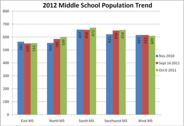
1 RAPID CITY AREA SCHOOL 51/ th Street Rapid City, SD Assistant Superintendent Student Achievement (605) , (605) Fax (605) Date: October 14, 2011 To: From: Cc: Subject: Board of Education, Dr. Mitchell Katie Bray Boundary Change Information Item Attached are the narrative descriptions and maps of the boundary changes proposed for the school year. All of the proposed changes reflect the information we shared with the community during the public hearings held during the school year. Of Note: Based upon feedback from the Autumn Hills/Corral Drive community, we have made the determination not to alter the current boundaries between Corral Drive and Meadowbrook. We are proposing to proceed with remainder of the boundary changes as proposed during the public hearings. You will also recall that last spring the BOE voted to approve the boundary changes between Knollwood and General Beadle and the district implemented those changes for the fall 0f Based upon feedback from the community, we proceeded with offering early special personal transfers to students who are currently 6 th graders. Parents had the option to request a transfer to the school which their student would be attending under the proposed new boundaries. Many of our families have taken advantage of the opportunity. We will follow the long standing grandfathering clause per Rapid City Area School District policy JECC which allows family the opportunity to stay in their current school if they fill out the paperwork within the stated timelines. Janet Kaiser has rerun the projected numbers for the 5 middle schools based upon the significant increased enrollment. Because the increased numbers are spread across the district, the proposed boundaries are still timely. See attached chart.
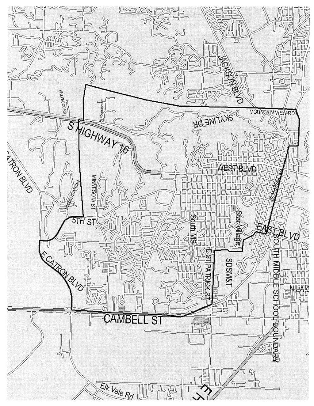
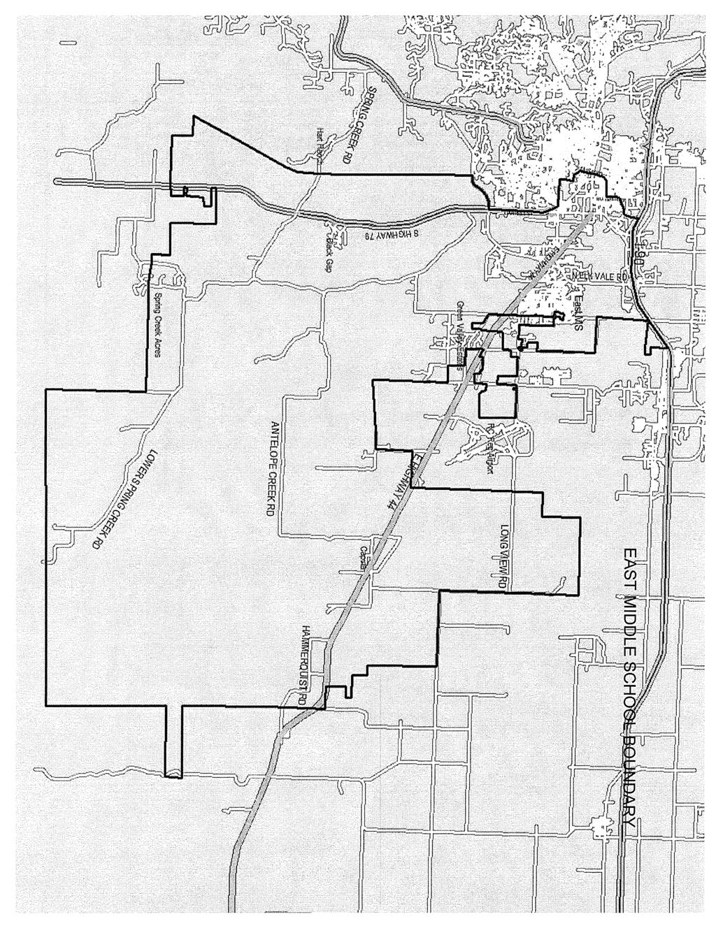
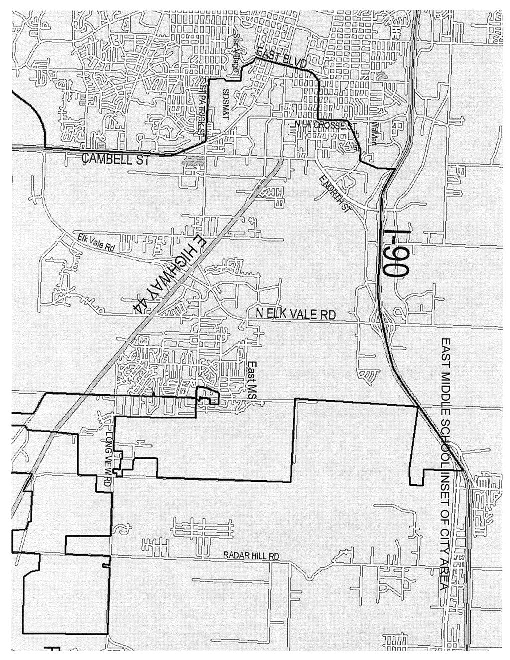
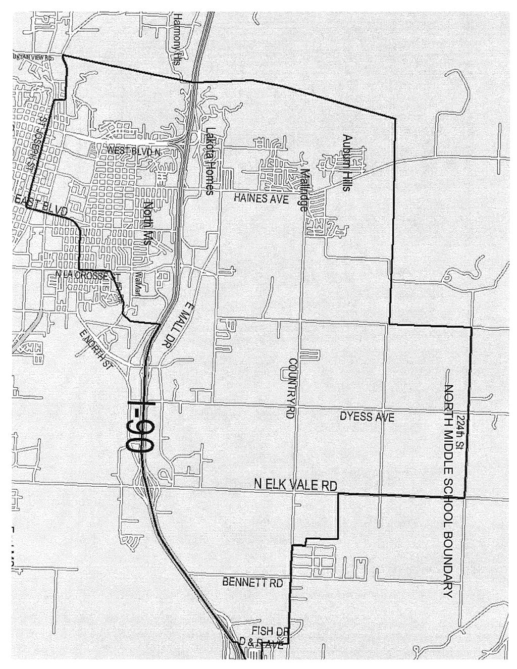
2 Landmarks referred to as School of Mines Hill - On East St. Patrick Street, west of Robbins Drive and East of Elm Avenue is an area that has no homes. It is behind the school of Mines. The boundary follows an imaginary line north through this area, then it goes west towards the east side of East Boulevard. It is on the east side of Star Village; it then travels northwest to the intersection of Quincy and East Boulevard. (See attached map.) South Middle School Beginning at the Northwest corner of the boundary area at West Omaha and Mountain View Road, the boundary line travels south to Jackson Boulevard. The line continues to travel straight south along the west side of Skyline Drive all the way to a point east of Springbrook Acres. The boundary turns east and crosses Highway 16 at a point north of Enchanted Hills continuing east to 5 th Street. It then follows 5 th Street south to Catron Boulevard, and then turns east toward Highway 79. At Highway 79, it travels north along the west side of Cambell Street following the St. Joseph Street exit to East St. Patrick Street. At that point the boundary goes west and includes the south side of East St. Patrick Street to the landmark referred to as the School of Mines Hill. The boundary line travels through the landmark and at Quincy and East Boulevard it turns north to East Boulevard and St. Joseph Street. It travels west along the south side of East St. Joseph Street to where St. Joseph Street meets West Main Street. It then goes north to West Omaha and follows the south side of West Omaha to where it meets Mountain View Road. (See attached map.) East Middle School Boundary The boundary area follows the district boundary line on the east from I-90 on the north to the southern edge of the Rapid City Area School district boundary, then to the west to and including both sides of Highway 79. It then goes north crossing Spring Creek Road about ½ mile west of where it intersects with Highway 79; it continues north to East Catron Boulevard, then along the east side of Cambell Street following the St. Joseph Street exit to East St. Patrick Street. At that point the boundary goes west and includes the north side of East St. Patrick Street to the landmark referred to as the School of Mines Hill. The boundary line travels through the landmark and at Quincy and East Boulevard, it follows the east side of East Boulevard and south side of East North Street to North LaCrosse Street, then it follows the east side of North LaCrosse Street to the railroad tracks just south of East Van Buren Street. At that point it follows the railroad tracks east to East Anamosa Street and then turns north on the east side of Sunnyside Avenue and continues to the south side of I-90; it then follows the south side of I-90 east to where the Rapid City School District Boundary and the Douglas School District boundary meet. (See attached map.) South Park/Valley View Boundary Change The following area, previously assigned to South Park will now be in the Valley View attendance area:
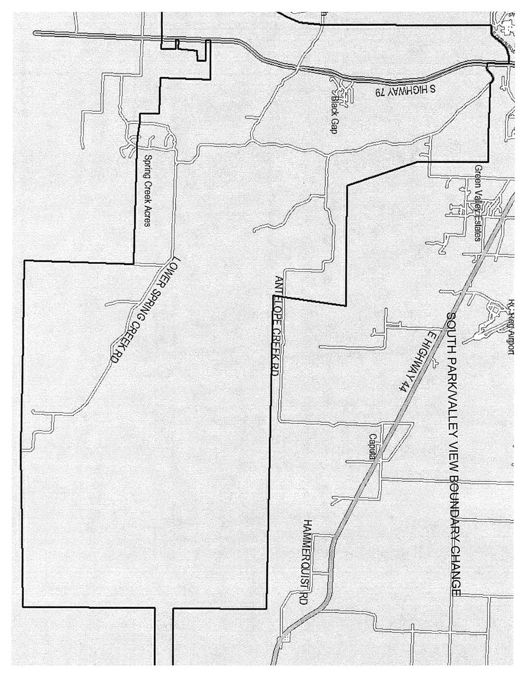
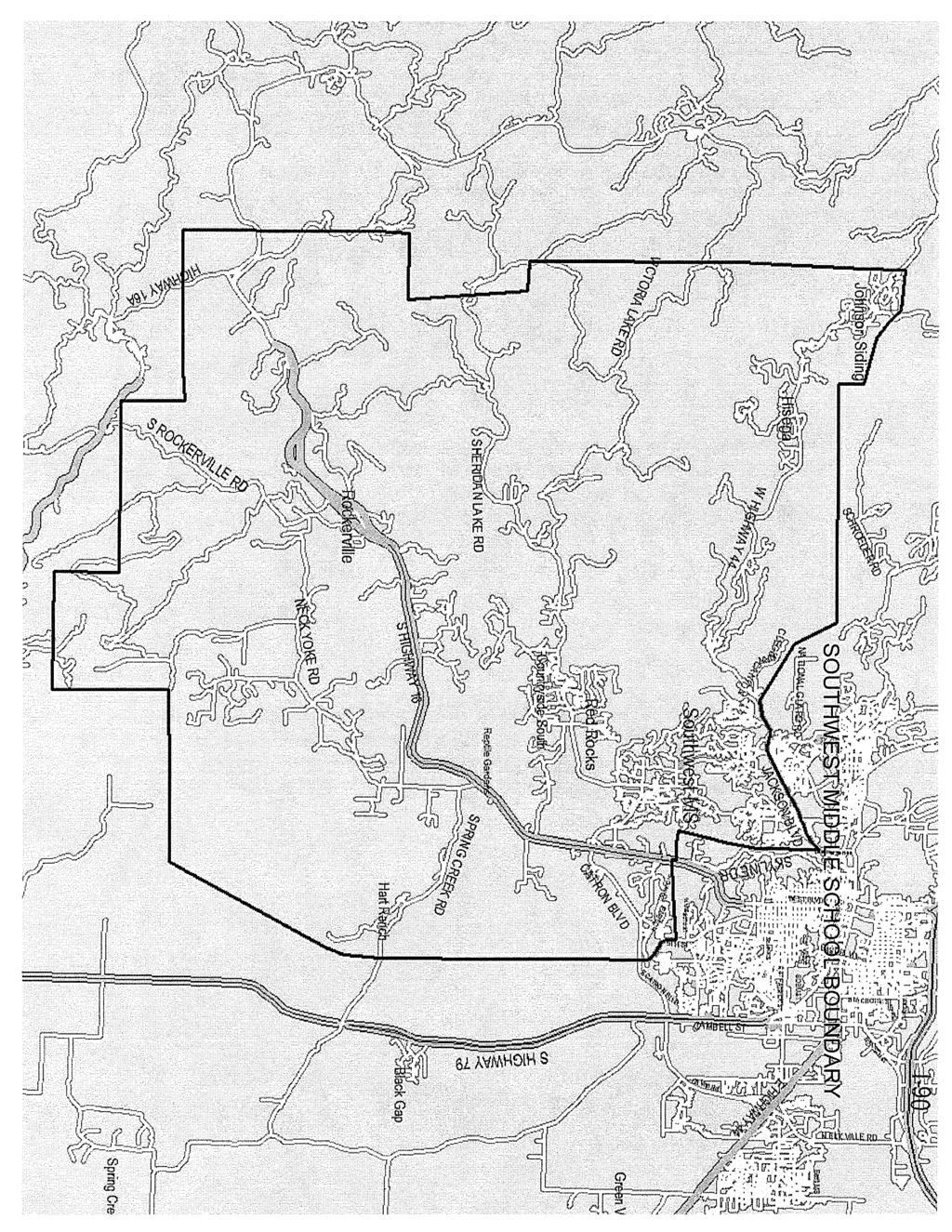
3 From the southern edge of the Rapid City School District Boundary the area encompasses the area along the west side of Highway 79, the boundary goes north crossing Spring Creek Road about ½ mile west of where it intersects with Highway 79; it continues north to East Catron Boulevard and then curves toward where Highway 79 connects with Elk Vale Road. The boundary line follows Highway 79 south to Old Folsom Road and goes straight east to a point west of Reservoir Road and then south through Lamb Road, just east of Kimberwick Road. The line stays east of Old Folsom Road and then turns east on the north side of Antelope Creek Road. Following the direction of Antelope Creek Road, the line stays north and east and then turns south to cross Antelope Creek Road at approximately address. It travels straight east to the east edge of the Rapid City District boundary, and then travels west along the south edge of the Rapid City District boundary. (See attached map.) North Middle School The boundary area follows the district boundary line on the north. On the east, from Country Road, it turns south just past Fish Drive. It juts to the east at the 700 block of D & R Avenue and then south again at West Gate Road. It turns southwest at the North I-90 Service Road and joins I-90. It follows I-90 to a point straight north of Eglin Street (approximately 1270 Eglin). It turns to the south and continues to the east of Sunnyside Avenue and then follows the railroad tracks to the southwest to a point on LaCrosse Street just south of East Van Buren. It travels south on the west side of North LaCrosse Street to the north side of East North Street continuing on the west side of East Boulevard and then turning west on the north side of St. Joseph Street to the point where it joins West Main. It then travels north to West Omaha and follows it to Mountain View Road. It continues straight north through the area east of Deadwood Avenue North and east of Harmony Heights. The boundary line continues to the northeast to the point that it joins the district boundary line on the north. (See attached map.) Southwest Middle School Boundary The boundary area follows the district boundary line on the southern edge from west of but not including Highway 79 to the western edge of the school district boundary. It then follows the western edge of the district boundary north to a point between West Highway 44 and Nemo Road on Norris Peak Road. From this point the boundary continues to the southeast through undeveloped areas. It goes south of the Schroeder Road area; then the line continues east towards Rapid City encompassing the area accessible from West Highway 44. At a point between the National Guard Road and Cleghorn Canyon, the boundary travels Southeast to where it meets Jackson Boulevard. The boundary then follows the south side of Jackson Boulevard to the intersection of Mountain View Road, turning south and traveling along the west side of Skyline Drive and encompassing the housing developments accessed from Sheridan Lake Road all the way to a point east of Springbrook Acres. The boundary turns east and crosses Highway 16 at a point north of Enchanted Hills traveling east to 5 th Street. It then follows 5 th Street south to Catron Boulevard and beyond. It
4 adjoins the west boundary of East Middle School along Highway 79. (See attached map.) Stevens/Central High School Boundary Change Students in the new Southwest attendance area along Highway 16 that previously attended Central High School, will now be in the Stevens attendance area. West Middle School At the northwest corner of the Rapid City Area Schools boundary, a point northwest of Rolling Hills Subdivision and north of Nemo Road, the boundary travels south along the school district boundary to a point between West Highway 44 and Nemo Road. It turns east and crosses Norris Peak Road and then travels southeast to encompass Schroeder Road; it travels east towards Rapid City encompassing areas accessible from Nemo Road. At a point between the National Guard Road and Cleghorn Canyon, the boundary travels Southeast to where it meets Jackson Boulevard. It follows the north side of Jackson Boulevard to the west side of Mountain View Road. It continues straight north through West Omaha and beyond through the area east of Deadwood Avenue north to Harmony Heights. It continues north of I-90 to the northern edge of the Rapid City Area School District Boundary. It then turns west and follows the existing northern boundary of the Rapid City Area Schools. (See attached map.)

5
6
7
8
9
10
11

12
13 2012 Boundary Counts October 5, 2011 Skyward Data Populations Within Boundaries October 5, Boundary K Total per Bldg East MS North MS South MS Southwest MS West MS Total Students Populations Within Boundaries (2012) 2012 Boundary 5th 6th 7th Total per Bldg Map Legend Chart Nov East MS North MS South MS Southwest MS West MS Total Students Populations Within Boundaries (2015) 2012 Boundary 2nd 3rd 4th Total per Bldg Map Legend Chart Nov East MS North MS South MS Southwest MS West MS Total Students Today 2012 (8-11) 2015 (5-8) CHS Counts (EMS-NMS- SMS) SHS Counts (SWMS-WMS) Total Students
14
2012 Boundary Counts October 5, 2011 Skyward Data Populations Within Boundaries October 5, 2011
 STUDENT ACHIEVEMENT ATTENDANCE BOUNDARY CHANGE BACKGROUND INFORMATION: As a result of closing Dakota Middle School at the end of the current school year and opening East Middle School, it is necessary
Springettsbury Township. Road Improvement Projects
 Springettsbury Township Road Improvement Projects 2009 2016 2016 Township Road Improvement Projects Springettsbury Township is divided into the following 4 Sectors: Northwest Sector Sherman Street Route
RETAIL (ON-OFF SALE) MALT BEVERAGE LICENSE VIDEO LOTTERY UPDATED 9/4/18. Renew Annually: July 1st
 MALT BEVERAGE LICENSE VIDEO LOTTERY UPDATED 9/4/18. Renew Annually: July 1st") Bach Investments, Inc. 1575 N. LaCrosse Street, Ste. D CCKT Inc 316 East Blvd Hideaway Casino 1575 N. LaCrosse Street, Ste. D Queen of Hearts Casino II 316 E. Blvd. Suite 110 RB-2962 RB-2998 CCKT Inc.
Bach Investments, Inc. 1575 N. LaCrosse Street, Ste. D CCKT Inc 316 East Blvd Hideaway Casino 1575 N. LaCrosse Street, Ste. D Queen of Hearts Casino II 316 E. Blvd. Suite 110 RB-2962 RB-2998 CCKT Inc.
RETAIL (ON-OFF SALE) MALT BEVERAGE LICENSE AND VIDEO LOTTERY. Renew Annually: July 1st
 MALT BEVERAGE LICENSE AND VIDEO LOTTERY. Renew Annually: July 1st") RETAIL (ON-OFF SALE) MALT BEVERAGE LICENSE AND VIDEO LOTTERY Renew Annually: July 1st OWNER NAME / Wyngard Pot O Gold Casino Inc. Lucky Ds Casino II 1330 E St Pat St #2 Rapid City, Wyngard Pot O Gold Casino
RETAIL (ON-OFF SALE) MALT BEVERAGE LICENSE AND VIDEO LOTTERY Renew Annually: July 1st OWNER NAME / Wyngard Pot O Gold Casino Inc. Lucky Ds Casino II 1330 E St Pat St #2 Rapid City, Wyngard Pot O Gold Casino
Retail On-Off Sale Malt Beverage with Video Lottery - Updated 2/22/2018
 Retail On-Off Sale Malt Beverage with Video Lottery - Updated 2/22/2018 OWNER NAME / ADDRESS BUSINESS NAME / ADDRESS CLASS - LICENSE NO. #2-East North Casino 230 East North Street RB-2946 MG Oil Rapid
RETAIL (ON-OFF SALE) MALT BEVERAGE LICENSE and VIDEO LOTTERY. Renew Annually: July 1st
 MALT BEVERAGE LICENSE and VIDEO LOTTERY. Renew Annually: July 1st") 1 Jackpot Casino II 685 "C" LaCrosse Street Rapid City, SD t57701 RB-2986 2 Wyngard Pot O Gold Casino Inc. Lucky Ds Casino II 1330 E St Pat St #2 Wyngard Pot O Gold Casino Inc. Lucky Ds Casino II 1330
1 Jackpot Casino II 685 "C" LaCrosse Street Rapid City, SD t57701 RB-2986 2 Wyngard Pot O Gold Casino Inc. Lucky Ds Casino II 1330 E St Pat St #2 Wyngard Pot O Gold Casino Inc. Lucky Ds Casino II 1330
APPENDIX IV MINOR HOCKEY ZONES
 221 APPENDIX IV MINOR HOCKEY ZONES To assist in the administration of Hockey Alberta, and to assist in carrying out the objectives of Hockey Alberta, the Province of Alberta will be divided into Zones,
IN THE CHANCERY COURT OF LAMAR COUNTY, MISSISSIPPI CIVIL ACTION NO.: CITY OF HATTIESBURG, MISSISSIPPI
 IN THE CHANCERY COURT OF LAMAR COUNTY, MISSISSIPPI IN THE MATTER OF THE INCORPORATION OF THE CITY OF BELLEVUE, MISSISSIPPI, BELLEVUE INCORPORATORS VS. CITY OF HATTIESBURG, MISSISSIPPI PETITIONERS CIVIL
O R D I N A N C E NO AN ORDINANCE, amending Section Two of Ordinance No. 1864, adopted April 3, 1969 and revising the boundaries of
 O R D I N A N C E NO. 2032 AN ORDINANCE, amending Section Two of Ordinance No. 1864, adopted April 3, 1969 and revising the boundaries of Subdistrict No. 268 (Lin-Ferry - Tesson Ferry) of The Metropolitan
United States Department of the Interior National Park Service. Boundary Expansion Listed in National Register January 11, 2017
 NPS Form 10900-a (Rev. 8/2002) OMB No. 10240018 United States Department of the Interior National Park Service Boundary Expansion Listed in National Register January 11, 2017 National Register of Historic
Rapid City Transit Development Plan. July Prepared for: Rapid City Growth Management Department
 Rapid City 2009-2013 Transit Development Plan July 2008 Prepared for: Rapid City Growth Management Department Rapid City Transit Development Plan 2009-2013 Prepared for: Rapid City Growth Management Department
Final Drainage Letter Pikes Peak Community College Downtown Parking Lot Colorado Springs, Colorado
 Final Drainage Letter Pikes Peak Community College Downtown Parking Lot Colorado Springs, Colorado Prepared for: Pikes Peak Community College 5775 South Academy Boulevard Colorado Springs, CO 80906-5422
Napa County Planning Commission Board Agenda Letter
 Agenda Date: 7/20/2011 Agenda Placement: 10A Napa County Planning Commission Board Agenda Letter TO: FROM: Napa County Planning Commission Hillary Gitelman - Director Conservation, Development & Planning
BE IT ORDAINED by the Mayor and the City Council of the City of Papillion as follows:
 ORDINANCE NO. 1798 AN ORDINANCE TO AMEND CHAPTER 24, SECTION 1 DELINEATING THE VOTING BOUNDARY WARDS FOR THE CITY OF PAPILLION; TO REPEAL THE EXISTING CHAPTER 24, SECTION 1; AND TO PROVIDE FOR AN EFFECTIVE
BUTCHER CREEK RANCH. Butcher Creek Ranch. Roscoe, Montana. Reduced to $1,650,000.
 BUTCHER CREEK RANCH Butcher Creek Ranch Roscoe, Montana Reduced to $1,650,000. Offered Exclusively By: Sonny Todd Real Estate 301 West First Avenue, PO Box 788 Big Timber, Montana 59011 Office: (406) 932-1031
RE: Request for de-annexation of Harney Peak Ranch lands from the City of Rapid City
 14AN002 September 2, 2014 Harney Peak Ranch Mr. David Lamb and Ms. Andrea Andersen, owner/operators 4555 Reservoir Road Rapid City, SD 57703 City of Rapid City City Council Planning Commission RE: Request
MESA COUNTY DEPARTMENT OF PUBLIC WORKS Administration - Building - Engineering Road and Bridge Traffic - Planning - Solid Waste Management
 MESA COUNTY DEPARTMENT OF PUBLIC WORKS Administration - Building - Engineering Road and Bridge Traffic - Planning - Solid Waste Management 200 S. Spruce St. P.O. Box 20,000 Grand Junction, Colorado 81502-5022
DECEMBER 15, :00 P.M.
 MOBILE CITY PLANNING COMMISSION AGENDA DECEMBER 15, 2016-2:00 P.M. AUDITORIUM, MOBILE GOVERNMENT PLAZA ROLL CALL Mr. Carlos Gant, Chairman Ms. Libba Latham (PJ), Vice Chairman Ms. Jennifer Denson, Secretary
SEPTEMBER 6, :00 P.M.
 MOBILE CITY PLANNING COMMISSION AGENDA SEPTEMBER 6, 2018-2:00 P.M. AUDITORIUM, MOBILE GOVERNMENT PLAZA ROLL CALL: Mr. Carlos Gant, Chairman Ms. Libba Latham (PJ), Vice Chairman Ms. Jennifer Denson, Secretary
THREE MILE PLAN TOWN OF SUPERIOR COLORADO
 THREE MILE PLAN TOWN OF SUPERIOR COLORADO February 23, 2015 INTRODUCTION This document has been prepared by the Town of Superior, Colorado, to address the existing and proposed land uses within an approximate
BY-LAW NO TO DIVIDE THE TOWN S TERRITORY INTO SIX ELECTORAL DISTRICTS
 BY-LAW NO. TO DIVIDE THE TOWN S TERRITORY INTO SIX ELECTORAL DISTRICTS ADOPTION PROCEDURE SUMMARY NOTICE OF MOTION: MARCH 21, 2016 ADOPTION OF BY-LAW: MAY 16, 2016 COMING INTO EFFECT: OCTOBER 31, 2016
MOBILE CITY PLANNING COMMISSION AGENDA JUNE 6, :00 P.M. AUDITORIUM, MOBILE GOVERNMENT PLAZA
 PAGE 1 MOBILE CITY PLANNING COMMISSION AGENDA - 2:00 P.M. AUDITORIUM, MOBILE GOVERNMENT PLAZA APPROVAL OF MINUTES: Terry Plauche, Chairman William G. DeMouy, Jr., Vice-Chairman Victoria L. Rivizzigno,
The north half of Section 18, Township 37 North, Range 6 East, Second Principal Meridian, Jefferson Township, Elkhart County, Indiana; also,
 The north half of Section 18, Township 37 North, Range 6 East, Second Principal Meridian, Jefferson Township, Elkhart County, Indiana; also, The east half of Sections 21, 28, and 33, Township 37 North,
TRAFALGAR PARK. 78: p.140 W 99th St FLAT ROCK CREEK PARK. W 103rd St OVERLAND PARK. Quivira Rd. College Blvd. Shared use path. Mountain bike trail
 Lenexa: overview TRAFALGAR PARK 78: p.140 As the Westport Route crosses over Lenexa's boundaries with Olathe and Overland Park several times, approximately 2.75 or 3 miles of the historic route of the
PROPOSED ALTERATION AND EXPANSION OF THE MOUNT PEARL MUNICIPAL BOUNDARY TO INCLUDE THE AREA OF THE FORMER PEARL ESTATE LANDS & ENVIRONS
 PROPOSED ALTERATION AND EXPANSION OF THE MOUNT PEARL MUNICIPAL BOUNDARY TO INCLUDE THE AREA OF THE FORMER PEARL ESTATE LANDS & ENVIRONS JANUARY 4, 2007 INTRODUCTION In accordance with Sections 3 to 6 inclusive
ORDI NANC E NO
 ORDI NANC E NO. 13622 AN ORDINANCE to amend the Official Zoning Map of the City of Des Moines, Iowa, set forth in Section 2A-5 of the Municipal Code of the City of Des Moines, 1991, by rezoning and changing
Royal Gorge Far Out Trail to Le Point
 Royal Gorge Far Out Trail to Le Point Direction to trailhead: From East Ridge Campground: Drive west from Canon City on US 50 to County Road 3A, the entrance road to the Royal Gorge Park. Turn left onto
Treaty Oaks Ranch 323+/- Acres Hood County, Texas $1,776,500
 Bret Polk Mobile: (254) 965-0349 Office: (214) 361-9191 Treaty Oaks Ranch 323+/- Acres Hood County, Texas $1,776,500 LOCATION: The ranch is located in a desirable area 10+/- miles south of Granbury, Texas,
RETAIL (ON-OFF SALE) MALT BEVERAGE LICENSE WITHOUT VIDEO LOTTERY. Renew Annually: July 1st
 MALT BEVERAGE LICENSE WITHOUT VIDEO LOTTERY. Renew Annually: July 1st") Justin Christman 919 Main ST #13 Matthew Sullivan PO Box 723 Cortez LLC 502 W Blvd Rapid 168 Inc 1900 N Maple Ave OWNER NAME / ADDRESS Black Hills Amateur Baseball Inc. c/o John Sayles 2610 Lawndale Dr.,
Justin Christman 919 Main ST #13 Matthew Sullivan PO Box 723 Cortez LLC 502 W Blvd Rapid 168 Inc 1900 N Maple Ave OWNER NAME / ADDRESS Black Hills Amateur Baseball Inc. c/o John Sayles 2610 Lawndale Dr.,
Figure 1: Little Dry Creek Trail Crossing
 Figure 1: Little Dry Creek Trail Crossing Figure 2: Little Dry Creek Trail Crossing Northwest Rail Environmental Evaluation Temporary Trail Detour Concurrence Form Adams County, Little Dry Creek Trail
ORDINANCE NO. 510 THEREFORE, BE IT ORDAINED BY THE GOVERNING BODY OF THE CITY OF BEL AIRE, KANSAS:
 (Published in The Ark Valley News on July, 2012.) ORDINANCE NO. 510 S-I-1 GILMORE & BELL, P.C. 07/11/2012 AN ORDINANCE CREATING A COMMUNITY IMPROVEMENT DISTRICT IN THE CITY OF BEL AIRE, KANSAS; AUTHORIZING
ALTA/ACSM LAND TITLE SURVEY Parts of Augusta Heights, First Section (Plat Book 20, Page 5), Augusta Heights, Second Section (Plat Book 19, Page 25),
, Augusta Heights, Second Section (Plat Book 19, Page 25),") ALTA/ACSM LAND TITLE SURVEY Parts of Augusta Heights, First Section (Plat Book 20, Page 5), Augusta Heights, Second Section (Plat Book 19, Page 25), and Augusta Park, 3rd Section (Plat Book 24, Page 132)
ALTA/ACSM LAND TITLE SURVEY Parts of Augusta Heights, First Section (Plat Book 20, Page 5), Augusta Heights, Second Section (Plat Book 19, Page 25), and Augusta Park, 3rd Section (Plat Book 24, Page 132)
CITY OF PALMDALE. REPORT to the Mayor and Members of the City Council from the City Manager
 CITY OF PALMDALE REPORT to the Mayor and Members of the City Council from the City Manager DATE: June 4, 2014 SUBJECT: Specific Plan Amendment 14-01; Amending the Use Designation of 23.97 Acres within
Fee:$O.OO P DAWSON CTY, MT Rec/Filed 1
 462708 Fee:$O.OO P DAWSON CTY, MT Rec/Filed 1 Shirley Kreiman, Clk & Rcdr By..; I ~::::!o:::!::::~~!..!:!~~~~ RETURN TO: FILED RESOLUTION 2017-33 RESOLUTION OF INTENTION TO CREATE RURAL SPECIAL IMPROVEMENT
Centennial Airport Flight school practice areas. A PowerPoint Presentation By Michael Shannon Chief Flight Instructor Aspen Flying Club
 Centennial Airport Flight school practice areas A PowerPoint Presentation By Michael Shannon Chief Flight Instructor Aspen Flying Club The Denver metro area airspace is very complex and congested. Centennial
MAY 17, :00 P.M.
 MOBILE CITY PLANNING COMMISSION AGENDA MAY 17, 2018-2:00 P.M. AUDITORIUM, MOBILE GOVERNMENT PLAZA ROLL CALL: Mr. Carlos Gant, Chairman Ms. Libba Latham (PJ), Vice Chairman Ms. Jennifer Denson, Secretary
KDOT announces approved November bids
 IMMEDIATE RELEASE Nov. 27, 2018 For more information: Kim Stich 785.296.3585 KDOT announces approved November bids The Kansas Department of Transportation announces approved bids for state highway construction
2014 NOTAM Special Flight Procedures. Indianapolis, IN Effective 0600 EDST (Local) May 30, 2014 Until 2000 EDST (Local) May 31, 2014
 May 30, 2014 Until 2000 EDST (Local) May 31, 2014") 2014 NOTAM Special Flight Procedures Indianapolis, IN Effective 0600 EDST (Local) May 30, 2014 Until 2000 EDST (Local) May 31, 2014 AIRCRAFT OWNERS AND PILOTS ASSOCIATION (AOPA) FLY-IN INDIANAPOLIS, IN
2014 NOTAM Special Flight Procedures Indianapolis, IN Effective 0600 EDST (Local) May 30, 2014 Until 2000 EDST (Local) May 31, 2014 AIRCRAFT OWNERS AND PILOTS ASSOCIATION (AOPA) FLY-IN INDIANAPOLIS, IN
Appendix I: Wetlands and Vernal Pools Functions and Values
 Appendix I: Wetlands and Vernal Pools Functions and Values Wetlands proposed to be impacted by each alternative were reviewed to determine what functions and values the wetland currently provides that
DECEMBER 6, :00 P.M.
 MOBILE CITY PLANNING COMMISSION AGENDA DECEMBER 6, 2018-2:00 P.M. AUDITORIUM, MOBILE GOVERNMENT PLAZA ROLL CALL: Mr. Carlos Gant, Chairman Ms. Libba Latham (PJ), Vice Chairman Ms. Jennifer Denson, Secretary
Sale Price: $650,000. Arlyn Dyce Broker Associate
 RETAIL FOR SALE 2223 Jackson Boulevard, Rapid City, SD 57702 STATE ST Updated April 2018 MOU BU MOUNTAIN VIEW RD Sale Price: $650,000 Highlights Rare opportunity for one of the best, most visible corners
GSO Architects represented by Lisa Swift NE Collins & I-30 Partners, LLC., represented by Jay Grogan
 Case Information Applicant: Property Owner: Sector Plan: GSO Architects represented by Lisa Swift NE Collins & I-30 Partners, LLC., represented by Jay Grogan North Council District: 1 Allowable Uses: All
Silver Center Development USA Parkway & Highway 50 Silver Springs, Nevada
 O f f e r i n g M e m o r a n d u m Silver Center Development USA Parkway & Highway 50 Silver Springs, Nevada 25.7 Acres presented exclusively by Ron Cobb Principal Direct: (775) 329-4000 x103 Cell: (775)
Part Three : COMMUNITY PLAN AREAS AND SPECIAL STUDY AREAS SACRAMENTO 2030 GENERAL PLAN. Introduction
 Special study Areas Part Three : COMMUNITY PLAN AREAS AND SPECIAL STUDY AREAS SACRAMENTO 2030 GENERAL PLAN Introduction Beyond the boundaries of the 2030 General Plan, the City has defined Special Study
AVAILABLE (RETAIL / OFFICE / INDUSTRIAL / RESIDENTIAL) NY ROUTE N.Y. THRUWAY, EXIT 16 Villages of Harriman & Woodbury, Orange County, NY
 NY ROUTE N.Y. THRUWAY, EXIT 16 Villages of Harriman & Woodbury, Orange County, NY") NY ROUTE 17 AVAILABLE ±130 ACRE MIXED-USE DEVELOPMENT SITE (RETAIL / OFFICE / INDUSTRIAL / RESIDENTIAL) NY ROUTE 17 @ N.Y. THRUWAY, EXIT 16 Villages of Harriman & Woodbury, Orange County, NY WOODBURY COMMONS
NY ROUTE 17 AVAILABLE ±130 ACRE MIXED-USE DEVELOPMENT SITE (RETAIL / OFFICE / INDUSTRIAL / RESIDENTIAL) NY ROUTE 17 @ N.Y. THRUWAY, EXIT 16 Villages of Harriman & Woodbury, Orange County, NY WOODBURY COMMONS
SPECIAL USE PERMIT - SUP Blue Valley Parkway
 NOTICE OF PUBLIC HEARING CITY PLANNING COMMISSION CITY OF OVERLAND PARK, KANSAS Notice is hereby given that the City Planning Commission of Overland Park, Kansas, will hold a public hearing Monday, April
HISTORIC SITE FORM HISTORIC SITES INVENTORY
 HISTORIC SITE FORM HISTORIC SITES INVENTORY 1 IDENTIFICATION Name of Property: House at 569 Park Avenue PARK CITY MUNICIPAL CORPORATION (10-08) Address: 569 Park Avenue City, County: Park City, Summit
ELKHORN PUBLIC SCHOOLS January District Growth and Facility Needs
 ELKHORN PUBLIC SCHOOLS January 2018 District Growth and Facility Needs New Schools Summary of Bond Resolution High School Middle School Elementary School Existing Facilities Land Acquisition $149,615,000
Albany. Corvallis Florence Green Trees. Philomath Florence Town Hayden Bridge Halsey McKenzie Valley
 Newport Newport Waldport Yachats See Florence/ Dunes City Map Toledo Lincoln County 230 Albany 225 - Florence Coast Village 234 - Pleasant Hill/Oakridge Corvallis 226 - Florence Green Trees Linn County
IOWA ORNITHOLOGISTS' UNION - Birding Sites in Linn County
 IOWA ORNITHOLOGISTS' UNION - Birding Sites in Linn County Printed on 6/15/2018 Bever Park (ebird Hotspot) GPS Coordinates: 41.9851219,-91.6269125 Restrooms Parking Trails ADA Accessible Trails Boyson Trail
Legal Status and Governing Board
 History The Wenatchee Reclamation District s formation and water rights began with a series of events beginning around the turn of the century. The District currently has right of 200 cubic feet per second
UMASS CROSS-COUNTRY Trails
 UMASS CROSS-COUNTRY Trails 1) EGG (43 min) (A) From Cage proceed to North Pleasant street (by campus pond). Make left and head toward LGRT and pass School of Education. Pass Puffton Apt complex (on left)
APPLICANTS PROPOSED TOUR SCHEDULE & PROTOCOL
 APPLICANTS PROPOSED TOUR SCHEDULE & PROTOCOL Pursuant to Paragraph 18 of the Procedural Order issued by the Chairman of the Power Plant and Transmission Line Siting Committee (the Committee ) on August
Honeywell Certified Installer Training Program. Training Facilities and Certification Policy
 Honeywell Certified Installer Training Program Training Facilities and Certification Policy Revised March 2018 Page 1 Honeywell Certified Installer Training Program When preparing to attend training please
Trail Beginning Elevation: 7553 ft The Poison Creek Trailhead is located at the end of National Forest Road 646E (NF-646E).
.") West Mountain Trails Poison Creek Trail #134 Length: 2.9 miles (4.7 km) Difficulty Horseback: A good trail for the first time west mountain rider, some steep sections Hiking: Most Difficult USGS Maps:
West Mountain Trails Poison Creek Trail #134 Length: 2.9 miles (4.7 km) Difficulty Horseback: A good trail for the first time west mountain rider, some steep sections Hiking: Most Difficult USGS Maps:
* ** Stanwood. Camano. School District. "k'kk
 Stanwood * ** "k'kk Camano School District TO FROM SUBJECT DATE TYPE BOARD OF DIRECTORS DR. JEAN SHUMATE, SUPERINTENDENT GARY PLATT, EXECUTIVE DIRECTOR - BUSINESS SERVICES DIRECTOR DISTRICT REBALANCING
COUNCIL OF THE TOWN OF LA PLATA Ordinance No a
 COUNCL OF THE TOWN OF LA PLATA Ordinance No. 12-21a ntroduced By: Mayor Roy G. Hale Date ntroduced: November 27 2012 Town Council Public Hearing: Amendments Adopted: N/A N/A Date Adopted: December 18 2012
Welcome to Natural Bridge
 Welcome to Natural Bridge Richard R. Randolph IV www.r4capital.com Www.r4land.com 205-879-5517 Work 205-413-8805 Fax 6 Carla Circle Birmingham, AL 35213 rich@r4capital.com Introduction NATURAL BRIDGE 160
DIRECTIONS TO HMG OFFICES
 DIRECTIONS TO HMG OFFICES AVON, ROUTE 10 100 Simsbury Road, Avon, CT 06111 (860)-284-5111 FROM I-84 WEST BOUND Take exit 43 (Park Road/West Hartford Center). Turn left at light at end of ramp. At second
1.2 Corridor History and Current Characteristics
 SECTION 1 Description and Background of Study Area 1.1 Introduction This preliminary engineering report was prepared for the Alaska Department of Transportation and Public Facilities (ADOT&PF). It is part
MOBILE CITY PLANNING COMMISSION AGENDA DECEMBER 3, :00 P.M. AUDITORIUM, MOBILE GOVERNMENT PLAZA
 MOBILE CITY AGENDA DECEMBER 3, 2015-2:00 P.M. AUDITORIUM, MOBILE GOVERNMENT PLAZA ROLL CALL: Mr. James (Jay) F. Watkins, Chair Mr. Carlos Gant, Vice Chair Mr. John Vallas Mr. Thomas Doyle Ms. Shirley Sessions
AVAILABLE FOR SALE ACRES-BEECHWOOD DRIVE ELYRIA, OHIO
 AVAILABLE FOR SALE 11.53 ACRES-BEECHWOOD DRIVE ELYRIA, OHIO Logos Realty Company 445 Griswold Road Elyria, OH 44035 Call Bob Graham at: 440-324-3550 Logosrealtyco2@windstream.net LAND SITE AVAILABLE BEECHWOOD
SAN RAFAEL CITY COUNCIL AGENDA REPORT
 Agenda Item No: 5.e Meeting Date: October 3, 2016 Department: Public Works SAN RAFAEL CITY COUNCIL AGENDA REPORT Prepared by: Bill Guerin, Director of Public Works TOPIC: QUIET ZONE DESIGNATION City Manager
THE ALBERTA GAZETTE, SEPTEMBER
 VILLAGE OF CEREAL Order No. 16915 IN THE MATTER OF THE "Municipal Government Act": File No. 241(A)3 AND IN THE MATTER OF an application by the Council of the Village of Cereal, in the Province of Alberta,
MINUTES OF THE ST. MARY S COUNTY PLANNING COMMISSION MEETING ROOM 14 * GOVERNMENTAL CENTER * LEONARDTOWN, MARYLAND Monday, April 26, 2004
 MINUTES OF THE ST. MARY S COUNTY PLANNING COMMISSION MEETING ROOM 14 * GOVERNMENTAL CENTER * LEONARDTOWN, MARYLAND Monday, April 26, 2004 Members present were John Taylor, Sr., Chairman; Lawrence Chase,
ORDINANCE NO. 612, DESCRIPTION ATTACHED
 Insert BOARD OF TRUSTEES, TOWN or PAGOSA SPRINGS STATE OF COLORADO ORDINANCE NO. 612, AMENDING ORDINANCE NO. 561, ESTABLISHING THE TOWN OF PAGOSA SPRINGS SANITATION ENERAL IMPROVEMENT DISTRICT, TO CLARIFY
OCTOBER 19, :00 P.M.
 MOBILE CITY PLANNING COMMISSION AGENDA OCTOBER 19, 2017-2:00 P.M. AUDITORIUM, MOBILE GOVERNMENT PLAZA ROLL CALL: Mr. Carlos Gant, Chairman Ms. Libba Latham (PJ), Vice Chairman Ms. Jennifer Denson, Secretary
April 10, Mark Stiles San Juan Public Lands Center Manager 15 Burnett Court Durango, CO Dear Mark,
 Mark Stiles San Juan Public Lands Center Manager 15 Burnett Court Durango, CO 81301 Dear Mark, We are pleased to offer the following comments on the draft San Juan Public Lands Center management plans
NOTAM. Aircraft Owners and Pilots Association (AOPA) Fly-In Colorado Springs Airport (COS) Colorado Springs, CO SPECIAL FLIGHT PROCEDURES
 Fly-In Colorado Springs Airport (COS) Colorado Springs, CO SPECIAL FLIGHT PROCEDURES") NOTAM Aircraft Owners and Pilots Association (AOPA) Fly-In Colorado Springs Airport (COS) Colorado Springs, CO SPECIAL FLIGHT PROCEDURES EFFECTIVE 12:00 Noon Local Friday, September 25, 2015 Until 6:00
NOTAM Aircraft Owners and Pilots Association (AOPA) Fly-In Colorado Springs Airport (COS) Colorado Springs, CO SPECIAL FLIGHT PROCEDURES EFFECTIVE 12:00 Noon Local Friday, September 25, 2015 Until 6:00
BRIDGEPORT. Metro Atlanta s Mega-Site. Pope & Land Enterprises, Inc Cumberland Boulevard Suite 400 Atlanta, GA
 18.660 AC AIRPORT ZONED 69.45 A U S H W Y 2 7 / 2 9 #4 60.074 AC C S X R A I L R O A D I N T E R S T A T E 8 5 #1 834.759 AC #5 69.141 AC Metro Atlanta s Mega-Site Pope & Land Enterprises, Inc. 3225 Cumberland
MOBILE CITY PLANNING COMMISSION AGENDA JULY 16, :00 P.M. AUDITORIUM, MOBILE GOVERNMENT PLAZA
 PAGE 1 MOBILE CITY PLANNING COMMISSION AGENDA - 2:00 P.M. AUDITORIUM, MOBILE GOVERNMENT PLAZA APPROVAL OF MINUTES: HOLDOVERS: June 19, 2008 and July 10, 2008 meetings. 1. Case #ZON2009-01303 William Youngblood
Boone County Commission Minutes 27 May Roger B. Wilson Boone County Government Center Commission Chambers
 TERM OF COMMISSION: PLACE OF MEETING: PRESENT WERE: May Session of the May Adjourned Term Roger B. Wilson Boone County Government Center Commission Chambers Presiding Commissioner Keith Schnarre District
Preliminary Site Evaluation
 Preliminary Site Evaluation 100 Acre Site, US 72 Piperton, Tennessee Power Distributor: Chickasaw Electric Cooperative August 2010 SITE DATA SHEET PIPERTON US 72 SITE (100 ACRES): LOCATION & GENERAL DESCRIPTION
CITY COUNCIL AGENDA MEMORANDUM
 To: Mayor and City Council From: Charles Ozaki, City and County Manager Prepared By: Kevin Standbridge, Deputy City and County Manager Katie Allen, City and County Engineer David Shinneman, Community Development
LIBERTY CATS 2014 TICA ANNUAL. Thank you for entering the 2014 TICA Annual show, brought to you by Liberty Cats!
 LIBERTY CATS 2014 TICA ANNUAL TRAVEL GUIDE Thank you for entering the 2014 TICA Annual show, brought to you by Liberty Cats! This travel guide will help you get around while visiting Massachusetts and
The following policy has been developed to help members safely fly the backcountry. BACKCOUNTRY FLYING PRIVILEGES:
 T - C R A F T A E R O C L U B B A C K C O U N T R Y F L Y I N G P O L I C Y PURPOSE: Flying in the Idaho and Northwest Backcountry provides a unique opportunity to access some of the world s most spectacular
Attachment D: PHOTO LOG CITY OF ARCATA RAIL-WITH-TRAIL CONNECTIVITY PROJECT
 01051-09004 Attachment D: PHOTO LOG CITY OF ARCATA RAIL-WITH-TRAIL CONNECTIVITY PROJECT DRAFT: June 30, 2010 Applicant: City of Arcata 736 F Street Arcata, CA 95521 Phone (707) 825-2154 Prepared by: Winzler
playwinterpark.com Off The Beaten Path Hikes Hiking Recommendations for the Adventurous Hiker
 playwinterpark.com Off The Beaten Path Hikes Hiking Recommendations for the Adventurous Hiker Hike: Devil s Thumb (difficult) Length: 3.93 miles one-way Elevation: Trailhead 9609 Destination 12,236 Trailhead
DAVIDSON LACROSSE CAMP for GIRLS Box 7158, Davidson, NC * (704) Phone * (704) Fax
 Phone * (704) Fax") CAMP INFORMATION GIRLS GRADES 7-12: Monday, July 11 th, 2016 Wednesday, July 13 th, 2016 Check-in @ 12:30pm; Check-out @ 2:30pm DUKE RESIDENCE HALL Camp begins at 2:00pm SHARP and ends at 2:30pm Airport
CAMP INFORMATION GIRLS GRADES 7-12: Monday, July 11 th, 2016 Wednesday, July 13 th, 2016 Check-in @ 12:30pm; Check-out @ 2:30pm DUKE RESIDENCE HALL Camp begins at 2:00pm SHARP and ends at 2:30pm Airport
Northwest Triangle. Redevelopment Proposal. Property Acquisition, Engineering, and Demolition. December, 2005 REDEVELOPMENT AUTHORITY OF THE
 Northwest Triangle Redevelopment Proposal Property Acquisition, Engineering, and Demolition December, 2005 REDEVELOPMENT AUTHORITY OF THE CITY OF YORK York City Redevelopment Authority 14 West Market Street,
Tinker Air Force Base, Oklahoma
 Table 5.4 Generalized Zoning within the Tinker AFB Clear Zones and Accident Potential Zones (Off-Installation) Category Acreage Residential 1,486 Commercial 191 Industrial 128 Public/Quasi-public 0 Recreational/Open/Agricultural/Low
APRIL 5, :00 P.M.
 MOBILE CITY PLANNING COMMISSION AGENDA APRIL 5, 2018-2:00 P.M. AUDITORIUM, MOBILE GOVERNMENT PLAZA ROLL CALL: Mr. Carlos Gant, Chairman Ms. Libba Latham (PJ), Vice Chairman Ms. Jennifer Denson, Secretary
Portable Noise Monitor Report
 Portable Noise Monitor Report Chicago O Hare International Airport Site 299 93 Wilshire Avenue, Elk Grove Village June 27, 217 through July 1, 217 USH8-ILH55-ILS28 Visit the O Hare Noise webpage on the
SPECIAL USE PERMIT - SUP West 159th Street. SBMS cell site 4459, Lot 1, a subdivision in Overland Park, Johnson County, Kansas.
 NOTICE OF PUBLIC HEARING CITY PLANNING COMMISSION CITY OF OVERLAND PARK, KANSAS Notice is hereby given that the City Planning Commission of Overland Park, Kansas, will hold a public hearing Monday, May
SERVICE AREA BOUNDARIES Beginning SFY2018
 SERVICE AREA BOUNDARIES Beginning SFY2018 Service Area A (1) Boundaries -- all of Ray County Ray County Fellowship Senior Center 1015 West Royle Richmond, Missouri 64085 Service Area B Beginning at I-435
OKLAHOMA'S HISTORIC ROUTE 66 AUDIO TOUR
 OKLAHOMA'S HISTORIC ROUTE 66 AUDIO TOUR Oklahoma s Historic Route 66 Audio Tour, created by the Oklahoma Historical Society, is an informative online audio tour that showcases the state's heritage and
PILOT INFORMATION PACKET
 PILOT INFORMATION PACKET Including Special Flight Procedures Indianapolis, IN May 31, 2014 AOPA FLY-IN HOST FBO: The AOPA Fly-in Host FBO at Indianapolis Regional Airport is Indy Jet. We thank them for
All that part of Lot 11, Sunset Hill, a subdivision in the City of Overland Park, Johnson County, Kansas, more particularly described as follows:
 NOTICE OF PUBLIC HEARING CITY PLANNING COMMISSION CITY OF OVERLAND PARK, KANSAS Notice is hereby given that the City Planning Commission of Overland Park, Kansas, will hold a public hearing Monday, February
1 The Cadastral Mapping Fee Order (AR 94/2000) is amended by this Regulation.
 is amended by this Regulation.") Alberta Regulation 21/2005 Surveys Act CADASTRAL MAPPING FEE AMENDMENT ORDER Filed: March 2, 2005 For information only: Made by the Minister of Sustainable Resource Development (M.O. 03/2005) on February
Alberta Regulation 21/2005 Surveys Act CADASTRAL MAPPING FEE AMENDMENT ORDER Filed: March 2, 2005 For information only: Made by the Minister of Sustainable Resource Development (M.O. 03/2005) on February
MOBILE CITY PLANNING COMMISSION AGENDA AUDITORIUM, MOBILE GOVERNMENT PLAZA ROLL CALL: Planning Commission July 19, 2018
 MOBILE CITY PLANNING COMMISSION AGENDA JULY 19, 2018-2:00 P.M. AUDITORIUM, MOBILE GOVERNMENT PLAZA ROLL CALL: Mr. Carlos Gant, Chairman Ms. Libba Latham (PJ), Vice Chairman Ms. Jennifer Denson, Secretary
CPW Extended Office Hours - Big Game Rifle Seasons October 13, November 18, 2018
 WILDLIFE OFFICES DATES/HOURS EXCEPTIONS BRUSH OFFICE 28167 CoRd T Brush, CO 80723 (970) 842-6300 COLORADO SPRINGS SOUTHEAST REGIONAL OFFICE 4255 Sinton Road Colorado Springs, CO 80907 (719) 227-5200 Closed
CITY OF BRIDGEPORT - GEODETIC CONTROL MONUMENTATION ESTABLISHED SEPTEMBER 2008
 1 - GEODETIC CONTROL MONUMENTATION ESTABLISHED SEPTEMBER 2008 In September 2008, Baird, Hampton & Brown established positions for 8 geodetic control monuments throughout the City of Bridgeport, Texas.
Site Location and Setting
 Memorandum Date: To: From: Subject: Kristy Le, Gary Black Steve Orem Santa Teresa County Park Historic Area Traffic and Parking Study Hexagon Transportation Consultants, Inc. has completed a traffic and
M I N U T E S OKLAHOMA COUNTY PLANNING COMMISSION
 M I N U T E S OKLAHOMA COUNTY PLANNING COMMISSION March 18, 2004 1:30 p.m. The meeting of the Oklahoma County Planning Commission convened and was called to order by Mr. Will Jones, Vice-Chairperson, at
PROPERTY OWNER PETITION FOR CONCURRENT DETACHMENT AND ANNEXATION
 PROPERTY OWNER PETITION FOR CONCURRENT DETACHMENT ANNEXATION IN THE MATTER OF THE PETITION BY ALL OF THE PROPERTY OWNERS FOR THE DETACHMENT OF CERTAIN L FROM THE CITY OF NOWTHEN, MINNESOTA CONCURRENT ANNEXATION
Published Counts TrafficMetrix
 Published Counts TrafficMetrix Contents Introduction... 1 TrafficMetrix Features... 1 TrafficMetrix Benefits... 1 TrafficMetrix Data... 1 File Descriptions... 2 State Abbreviations... 3 Count Type Glossary...
Southwest LRT Alignment Video Narration
 Southwest LRT Alignment Video Narration September 2015 Southwest Light Rail Transit, a proposed extension of the METRO Green Line, will serve Minneapolis, St. Louis Park, Hopkins, Minnetonka and Eden Prairie.
PASCO (Pacific Soaring Council) ADVISORY TO GLIDER PILOTS
 ADVISORY TO GLIDER PILOTS") PASCO (Pacific Soaring Council) ADVISORY TO GLIDER PILOTS RECOMMENDED COMMUNICATIONS PROCEDURES FOR FLYING GLIDERS IN THE VICINITY OF RENO, NV The airspace around Reno has the highest number of glider-commercial
PASCO (Pacific Soaring Council) ADVISORY TO GLIDER PILOTS RECOMMENDED COMMUNICATIONS PROCEDURES FOR FLYING GLIDERS IN THE VICINITY OF RENO, NV The airspace around Reno has the highest number of glider-commercial
METROPOLITAN PLANNING COMMISSION CONSENT APPROVAL LIST SEPTEMBER 14, 2017
 METROPOLITAN PLANNING COMMISSION CONSENT APPROVAL LIST SEPTEMBER 14, 2017 These items are recommended for approval on consent and are marked (*) on the Agenda. They will be considered under one motion
April 25, Dr. Littrell called the meeting to order at 7:06 p.m. and Mr. Dickson lead in invocation and pledge.
 The Carroll County Board of Supervisors held a budget work session on, April 25, 2011 in the Board Meeting Room of the Carroll County Governmental Center. Present were: Dr. Thomas W. Littrell David V.