Activity 1 - Where is Brazil? Using a map or atlas to help you:
|
|
|
- Mildred Miles
- 5 years ago
- Views:
Transcription
1 Activity - Where is Brazil? Using a map or atlas to help you: Label all the countries of South America 2 Mark and name the Equator and the Tropic of Capricorn 3 Mark and name the Amazon River, and the cities of Brasília, São Paulo and Rio de Janeiro 4 Name the Atlantic Ocean, Pacific Ocean, South Atlantic Ocean 5 Tierra del Fuego and Cape Horn Activity - Where is Brazil?
2 Activity 2: Find these places in Brazil. Label these cities: São Paulo 2 Rio de Janeiro 3 Manaus 4 Brasilia 5 Recife 6 Boa Vista 7 Salvador 8 Aracaju 9 Belém 0 Porto Alegre Where are these rivers? Colour them blue. Amazon 2 Tocantins 3 São Francisco 4 Negro 5 Xingu 6 Paraná Activity 2: Find these places in Brazil
3 Activity 3 - The weather in South America Visit this website which shows the weather conditions in South America. You can click on temperature, rain, cloud and winds to see the changes over the continent. Where is it hottest? 2 Where is it cloudy? 3 Is it raining anywhere? 4 Where is the sea warmest and coldest? YOUR TASK You have been asked to write a short report for BBC news about the weather in South America today. Use the information you can see on line as well as your knowledge about places in South America to create your report. These phrases may help you. Temperatures are expected to be around. varying from. Cloudy skies are over. Cloud / winds are moving. Rain is expected. not expected.. Good morning.the weather in South America today Activity 3 - The weather in South America
4 Activity 4 - What's the weather like today? Date: / / Visit this website to find the weather for places in Brazil. Describe the weather in Manaus and São Paulo. MANAUS Daytime temperature Night time temperature Rain? Cloudy? Sun rises at? Sun sets at? Number of hours of daylight? Outlook for tomorrow? Activity 4 - What s the weather like today?
5 SÃO PAULO Daytime temperature Night time temperature Rain? Cloudy? Sun rises at? Sun sets at? Number of hours of daylight? Outlook for tomorrow? Now find the weather forecast for your area today. 2 How is it similar or different to the weather in Brazil? 2 Schools Pack Brazil 2009
6 Activity 5 - Comparing the weather Weather data for Manaus Brazil Jan Feb Mar April May June July Aug Sept Oct Nov Dec Temp in C Rainfall In mm Weather data for Tenby S. Wales Temp in C Rainfall In mm Plot the statistics for the two locations above on two graphs. Use bars for the rainfall and a line graph above to plot the temperature. Have a look in an atlas to see what a climate graph looks like. Questions on the graphs Which place has the highest rainfall? 2 Which place has the largest range of temperature? (in each place take the lowest temperature figure from the highest to find the range) 3 Describe what sort of weather to expect if you visited each place in February? 4 Which month would be best to visit a) Manaus b) Tenby? 5 The temperatures given are the average for the month. So how might you expect the temperature to vary in the two places in January? 6 From looking at the data for Manaus do you think they experience seasons in the same way as in Tenby? It is unlikely that people in Manaus will have ever seen snow. Write a description of snow and frost to explain what they are like. Read your explanations to a partner and then discuss how you might improve your description. What are the benefits of living in each climate? Which one would you prefer to live in? Why? Look up the weather in each place for today s date on How does this match with the data you already have? Activity 5 - Comparing the weather

7 Activity 6 - The Tropical rainforest Look at this picture which shows the tropical rainforest in the Amazon Basin. It rains every day in this area often as thunderstorms in the late afternoon. The temperature is high all the year round as it is near the Equator, so the vegetation grows very fast. The trees grow high to find the sunlight they need to help them make food. There are 4 main layers in the rainforest The high canopy of leaves at the top The tree layer growing to reach the sunlight The shrub layer where it is often dark helping lianas and lichens to grow The forest floor made up of plants, humus made from dead vegetation, and marshy ground all of which teems with life Can you write in the name of each layer and complete the picture below? Activity 6 - The Tropical rainforest
8 Activity 7 - Tropical rainforests T rainforests are found across the world usually between the Tropic of C and the Tropic of C. They cover about % of the world. It rains nearly every in the forest, often up to metres falling over the year. This means it is usually h and s which encourages the vegetation to grow very f. A huge variety of a, b and insects are found in the different layers of the forest. The forest floor is dark, hot and m with many pools of w which encourages a great variety of wildlife to live there such as leeches, spiders, s, monkeys, and even larger animals such as jaguars. In the higher sections birds such as p and toucans as well as animals like monkeys, boa constrictors, and sloths all find a home. Much of the rainforest particularly in South America is being cleared at the rate of 4000 football pitches an hour which is pretty fast! The problem is that the heavy r tends to wash away the s once the vegetation is removed and that makes the farmland very poor quality. It also means that many creatures and plants are losing the habitat which provides them with their h Capricorn 7 tropical steamy farm homes parrots cattle 2 rain animals water birds Cancer day hot soil steamy muddy quickly Activity 7 - Tropical rainforests
9 Activity 8 - People of Brazil Use Fact Sheet 3 to help with this task. The people of today are descended from groups of people from different parts of the. Some are the original of the country who are known as the native population. Others came from and these had followed the early who had settled when the land was first discovered in the century. As time went on, cane was introduced to the country and grown in large. As there were not enough local for these plantations, some Indians and slaves were forced to in them. Local workers and European immigrants and this was the start of a mixed race that is a feature of Brazilian culture today. During the century, many people travelled from o start new lives there. Brazil now has the largest population in the world after India,, China and Indonesia. Its population today is estimated at more than million. Missing words: Portugal fifth 88 inhabitants Brazil USA plantations explorers world twentieth population intermarried work sugar Indian sixteenth workers African Europe. Activity 8 - People of Brazil


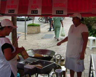
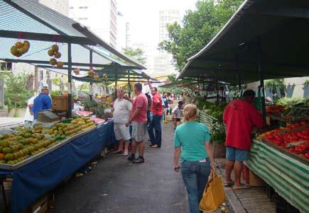
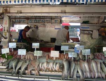
10 Activity Sheet 9 - Using Photographs Using photographs some ideas of what to look for What does the picture tell you about what the land is like? What features can you identify? What type of vegetation can you see? Is the land flat or hilly? Can you see any rivers, valley or coast? What else does the picture tell you about the landscape? 2 What does the picture tell you about what the place is like? Can you tell what type of climate it has? What evidence can you see of people? Is this a busy or quiet place? How do you know? Would you like to visit it? Why or why not? Is this a natural or built environment? Embratur Erika Tambke Dalmo Próspero Dalmo Próspero Activity Sheet 9 - Using Photographs


11 3 What does the picture tell you about how people live? Can you see any settlements? What are they like? What can you tell about the houses and buildings? Do you think this place could be in the UK? Why or why not? 4 What does this picture tell you about what people do? Does it show how people grow things? Can you see any evidence of people making things? Are there any people transporting things? Does it show people buying or selling things? Does it tell you how people travel? What else does the picture tell you? Laura Barbi 2 Schools Pack Brazil 2009


12 5 What does the picture tell you about how the land is used? Is it used for farming? For animals or crops? Can you see land used for buildings or development? Can you see it being used for sport or leisure activities? Is any land used for quarries, pits or mines? Is there any wild area? Is there any evidence of pollution? Erika Tambke Erika Tambke José Medeiros Dalmo Próspero Activity Sheet 9 - Using Photographs 3
13 Activity 0 - Information from Photographs Look at your pictures and see how many of the features you can find. Tick in the correct box for each picture. FEATURE PICTURE PICTURE 2 PICTURE 3 PICTURE 4 Farming Coasts Streets Vegetation Mountains/Hills Dense housing Main roads Pollution River/streams/lakes Scattered buildings People working Animals Evidence of railways Small local roads Activity 0 - Information from Photographs


14 Which of the features above are natural and which are made by people? 2 Which appeared in all the pictures you looked at? 3 Which was the most difficult to identify? Why? 4 Can you put the above items in the list into alphabetical order? Erika Tambke Dalmo Próspero Laura Barbi 2 Schools Pack Brazil 2009
15 Activity - Reading photographs Choose a photograph and decide on a caption or title: Some labels for the picture might be: 2 The questions I would like to ask about what is happening in the picture are: 3 In 20 year s time changes in the picture might include: 4 In 00 year s time the changes might be: Activity - Reading photographs


16 2 Schools Pack Brazil 2009
17 Activity 2 - Writing my diary A diary day in my country First write a diary entry for your self choosing a normal school day. Start with getting up and having breakfast. You might like to include something about the season or the weather or any festivals which might be happening soon. A diary day in Brazil Now do the same for one of the children you have read about in Brazil. You will have to be a bit of a detective in finding out as much information as you can. You can use some of the pictures to help you as well as the accounts of what the children do. What happens if it is a really rainy day? How does that affect your life there? You will need to be creative in using the information to make a really good diary entry! Activity 2 - Writing my diary
18 Activity Sheet 3 - How do we compare? Using the headings as starting points write some notes in the boxes about the place you live in and compare it with a chosen location in Brazil Where I live in Brazil Landscape Weather and climate Streets Vegetation Food Houses and buildings How people earn their living Activity Sheet 3 - How do we compare?
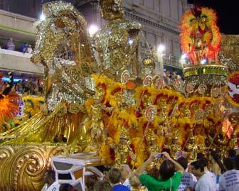
19 Activity 4 - World Cup 204 The football World Cup will be held in Brazil in 204. The competition was previously held in Brazil in 950, when Uruguay beat the hosts in the final. The world s largest stadium, Maracanã, was built in Rio de Janeiro for this purpose. It is one of the largest and most famous sports venues in the world, with a capacity of almost 00,000. Now all-seater, the Maracanã used to be capable of holding even bigger crowds, the largest of which was almost 200,000 (still the world-record football attendance) for the 950 World Cup final. The competition in 204 will be held in 2 cities across the country. The selected cities are Belo Horizonte, Brasília, Cuiabá, Curitiba, Fortaleza, Manaus, Natal, Porto Alegre, Recife, Rio de Janeiro, Salvador and São Paulo. The FIFA decision means there will be two World Cup venues in south Brazil (Curitiba, Porto Alegre), three in the south-east (Belo Horizonte, Rio de Janeiro, São Paulo), one in the centralwest (Cuiabá), one in the federal district of Brasília, one in the north (Manaus), and four in the north-east (Fortaleza, Natal, Recife, Salvador). The 204 World Cup will be the first in Brazil since 950. Using the map of the country, name the twelve cities. 2 Which of these journeys is the longest? Brasília and Manaus Recife and São Paulo Salvador and Porto Alegre Belo Horizonte and Curitiba Fortaleza and Natal Activity 4 - World Cup 204
20 Plot a journey to each of the twelve cities starting in Rio de Janeiro. Calculate the shortest route you could take and list the cities in the order you would visit them. 2 Schools Pack Brazil 2009
21 Activity 5 - True or False? Work with a partner to find out if the following statements are true or false? Brazil shares a border with all the other countries in South America 2 Brazil is north of Venezuela 3 La Paz is the capital of Brazil 4 The River Amazon enters the sea near the city of Rio de Janeiro 5 Brazil is the second largest country in South America 6 The highest mountain in Brazil is the Pico da Neblina 7 The Amazon Basin is home to the world s largest tropical rainforest. 8 The Indian Ocean is part of Brazil s coastline. 9 The official language of Brazil is Spanish 0 The population of Brazil today is around 70 million people The most densely populated part of Brazil is the Amazon lowlands The large continent north of Brazil is Asia South America is joined to North America. The southern most country in South America is Bolivia The largest landmass to the south of South America is Antarctica Activity 5 - True or False?
22 Activity 6 - True or False? Brazil is the fifth largest populated country in the world. 2 Its population today is estimated at more than 55 million. 3 Two thirds of these people live in towns and cities and most people live along the coast. 4 About 62% of the population is below the age of About a half of the country is rainforest while the other half is covered by grassland, pine forests and some semi desert. 6 More people live in and around São Paulo than in Greater London. 7 Nearly two thirds of the population live in cities. 8 Fifty years ago less than half of the people in Brazil lived in cities. 9 São Paulo is Brazil s largest city. Brazil has the largest population of Japanese people outside Japan. An off shore oil field has been discovered which could amount to the world s third largest reservoir. Rio de Janeiro is the capital of Brazil. Beach volleyball is the most popular sport in Brazil. The Spanish were the first European explorers to discover Brazil. Brazil has borders with eleven other South American countries. Brazil produces biofuels which can be used to run vehicles instead of petrol. Activity 6 - True or False 2?

23 Activity 7 - learning from photographs Look carefully at the photograph and then answer the questions. What are the pedestrians doing? 2 What is the main issue here? 3 What do you think the buildings are used for? 4 What function does the bike have? 5 Can you find any air conditioning units? 6 What is the weather like here? What are the clues? Activity 7 - learning from photographs


24 Activity 8 - learning from photographs 2 Look carefully at the photographs and then answer the questions. What is being sold in the market? 2 Who are the customers? 3 Why do markets attract people? Should plastic bags be charged for? 4 If you were visiting this market, what would you see, hear and feel? 5 How does the produce get to the market? 6 Which season is it? How do you know? 7 How does this market compare with one you know? Activity 8 - learning from photographs 2


25 Activity 9 - learning from photographs 3 Look carefully at the photographs and then answer the questions. What information can you find here? 2 Where might this place be? 3 Is this a town or a city? What is he reason for your answer? 4 Is the place still growing? 5 Is this a pleasant or unpleasant area? What is the reason for your answer? 6 What type of jobs might be here? Juliana Vidigal Antonio Silva Embratur Activity 9 learning from photographs 3

26 Activity 20 - learning from photographs 4 Look carefully at the photograph and then answer the questions. What animals are these? 2 What product might come from them? 3 What is the vegetation like? 4 Do the animals look well fed? 5 Was this photograph taken in Britain? What are the clues? 6 Which other animals might the farmer keep? 7 Which season do you think it is? Why? Laura Barbi Activity 20 - learning from photographs 4

27 Activity 2 - learning from photographs 5 Look carefully at the photograph and then answer the questions. What are the facilities here? 2 Is it a modern or old beach resort? 3 What is the landscape like? 4 What is the weather like now? 5 How might this change? 6 If you were on the beach here, what would you like to do? Activity 2 - learning from photographs 5

28 Activity 22 - learning from photographs 6 Look carefully at the photograph and then answer the questions. What type of vehicles can you see? 2 What is the reason for the high wall and dense vegetation on either side? 3 Where is the city centre? 4 Why are there more cars on one side of the road? 5 What time of day of you think it is? 6 Which type of vehicles are missing? 7 If you were in this picture, what would you hear, feel and see? Activity 22 - learning from photographs 6


29 Activity 23 - learning from photographs 7 Look carefully at the photographs and then answer the questions. Where do think this street might be? Why? 2 How many different types of transport can you see? 3 Is it a main road? How do you know? 4 What are the buildings used for? 5 What type of day might this be? Why do you think so? 6 What is the weather like? José Medeiros Laura Barbi Antonio Silva Activity 20 - learning from photographs 4


30 Activity 24 - learning from photographs 8 Look carefully at the photographs and then answer the questions. What is the climate like here? 2 Which part of the city might this be? 3 What are these buildings used for? 4 Why are so many buildings high rise? 5 Are the buildings all of the same age? 6 What type of shops can you find? 7 What type of jobs might people do here? Embratur Activity 24 - learning from photographs 8

31 Activity 25 - learning from photographs 9 Look carefully at the photograph and then answer the questions. What are the main materials that are used in this room? 2 Which room is this and what is it used for? 3 Is this house in Britain? What is the reason for your answer? 4 Where do you think the door leads to? 5 Compared to the picture, how is a room in your house: Similar Different Marion Weber Activity 25 - learning from photographs 9


32 Activity 26 - learning from photographs 0 Look carefully at the photographs and then answer the questions. Can you work out what the building is used for? 2 Why is there no door? 3 How is the building closed at night? 4 Where do you think this building is located? 5 What is the environment around the building like? 6 What is the man in the photo doing? How did he get there? 7 Is this place in Britain? How can you tell? 8 Would there be a similar place in Britain? Antonio Silva Antonio Silva Laura Barbi Activity 20 - learning from photographs 4
1 What do you know about Brazil? What. 2 What would you like to know about Brazil? 3 Look at the short movie clips below to see
 This fact sheet introduces you to the beautiful country of Brazil with its varied scenery. 1 What do you know about Brazil? What is Brazil famous for? Make a list of the facts that you know about the country
2.1 What is the climate like?
 José Medeiros This fact sheet allows you to see how varied the countryside is across Brazil. 2.1 What is the climate like? Most of Brazil is in the Southern Hemisphere, where the seasons are the opposite
Introduction. We hope you find these materials useful and would welcome any feedback.
 Introduction This planning pack was produced with teachers from County Durham following a visit to São Paulo. The materials support the teaching of geography at key stage one and two within the context
South America. pg. 520 (5 th) pg. 523 (6 th )
 pg. 523 (6 th )") South America pg. 520 (5 th) pg. 523 (6 th ) Venezuela Rich in Oil Lake Maracaibo Called Little Venice pg. 572 (5 th) pg. 574 (6 th ) Caracas 8 miles Inland 3000 pg. 572 (5 th) pg. 574 (6 th ) Caracas
South America pg. 520 (5 th) pg. 523 (6 th ) Venezuela Rich in Oil Lake Maracaibo Called Little Venice pg. 572 (5 th) pg. 574 (6 th ) Caracas 8 miles Inland 3000 pg. 572 (5 th) pg. 574 (6 th ) Caracas
Here you will find out how Brazil developed over the centuries and why people travelled to live in the country.
 Here you will find out how Brazil developed over the centuries and why people travelled to live in the country. The people of Brazil are descended from people who came from many other parts of the world.
Macmillan Cultural Readers ELEMENTARY LEVEL. Brazil MACMILLAN
 Macmillan Cultural Readers ELEMENTARY LEVEL SUSAN HOLDEN AND Alberta White Brazil MACMILLAN Macmillan Cultural Readers ELEMENTARY LEVEL Founding Editor of the Macmillan Readers: John Milne The Macmillan
Fifa World Cup shakes Brazilian Tourism trends
 Fifa World Cup shakes Brazilian Tourism trends The Study Main findings 10 main source countries 10 International arrivals Domestic travel Host cities Outbound Tourism from Brazil Trends The Study A study
STUDY GUIDE. The Land. Physical Features of Latin America. Chapter 8, Section 1. Terms to Know DRAWING FROM EXPERIENCE ORGANIZING YOUR THOUGHTS
 For use with textbook pages 193 198. The Land Terms to Know cordillera A mountain range that runs parallel to another mountain range (page 194) altiplano A high plain (page 194) escarpment A steep cliff
Portuguese Language - Fostering National Unity
 Geography Brazil Brazil Portuguese Language - Fostering National Unity 11 dialects of Portuguese Influenced by Amerindian and African languages, creating differences between Portuguese spoken in Brazil
Chapter 19 Test on South America
 Name Part 1 - Labeling (27 pts.) Chapter 19 Test on South America Score A. Locate the countries and territory contained in the word box below on the map of South America on the next page. Write the name
Geographic Qualities of South America
 Geographic Qualities of South America 1. South America is the fourth largest continent in area. It is located in the Western Hemisphere, lying southwest of North America. Most of South America lies in
A funny sounding lake. South American Landforms, Climate, and Vegetation
 A funny sounding lake South American Landforms, Climate, and Vegetation 3 4 Essential Question: How have physical features and climate affected the population distribution of Latin America? 5 I. Landforms
LOCATION, LOCATION, LOCATION! Mexico, Venezuela, Cuba, and Brazil
 LOCATION, LOCATION, LOCATION! Mexico, Venezuela, Cuba, and Brazil GPS and E.Q. GPS: SS6G3 The student will explain the impact of location, climate, distribution of natural resources, and population distribution
DATE: A Short Introduction
 Question: What do you already know about Brazil? Read the article below and then answer the questions. A Short Introduction Brazil is big. It is the largest country in South America, and the fifth largest
The Northern Tropics
 The Northern Tropics The Guianas Countries Guyana, Suriname, French Guyana Culture reflects colonial history Official Languages Guyana English Suriname Dutch French Guyana - French Religions Suriname and
Brazil. Population & Culture
 Brazil Population & Culture Population of Brazil Largest country in South America 200 million people (2012 est) Growing population - approximately 1% per year Life expectancy - approx 72 years Population
LOCATION, CLIMATE, AND NATURAL RESOURCES OF MEXICO
 SS6G3 The student will explain the impact of location, climate, distribution of natural resources, and population distribution on Latin America and the Caribbean. a. Compare how the location, climate,
Latin America and The Caribbean. A Closer Look.
 Latin America and The Caribbean A Closer Look. Mexico Capital: Mexico City The Location of Mexico Mexico is the second-largest country by size and population in Latin America.but the Largest Spanish -
Introduction to Africa
 Introduction to Africa Did you know? Africa has more countries than any other continent. The Sahara is a desert that is the size of the U.S. It s the world's largest desert. Most of the world s gold and
Brain Wrinkles. Africa: The impact of location, climate, & physical characteristics on where people live, the type of work they do, & how they travel
 Africa: The impact of location, climate, & physical characteristics on where people live, the type of work they do, & how they travel STANDARDS: SS7G3 The student will explain the impact of location, climate,
The Lesser Antilles. Dominican Republic), and Puerto Rico
, and Puerto Rico") The Caribbean Islands are archipelagoes or groups of islands. The major archipelagoes are: The Greater Antilles - Cuba, Jamaica, Hispaniola (Composed of Haiti and the Dominican Republic), and Puerto Rico
The Caribbean Islands are archipelagoes or groups of islands. The major archipelagoes are: The Greater Antilles - Cuba, Jamaica, Hispaniola (Composed of Haiti and the Dominican Republic), and Puerto Rico
*Latin America spans 7,000 miles, from Mexico to Tierra Del Fuego. *3 Regions: Central America, South America, and the Caribbean.
 Physical Geography Latin America spans 7,000 miles, from Mexico to Tierra Del Fuego *3 Regions: Central America, South America, and the Caribbean. *Intro clip: http://www.youtube.com/watch?v=cffp6rza3
Africa 1. About how many miles is it from the capital of Burkina Faso to the capital of Gambia? 3. What country has the second highest birthrate?
 Pts Answers - (Write answers in Answers column. Do Not mark in Pts. Column.) Africa 1. About how many miles is it from the capital of Burkina Faso to the capital of Gambia? 2. The continent's two largest
Objective. Students will familiarize themselves with the physical features and climates of Latin America.
 Journal Write KWL What do you KNOW about Latin America? What do you WANT TO KNOW about Latin America? What did you LEARN today that you didn t know before? Latin America Objective Students will familiarize
The Geography of Climate
 The Geography of Climate Objective for Today: Today we will examine ways that latitude and landforms influence climate The focus of our study will be the South American Continent in the Formal Region known
Brazil. Brazil A Reading A Z Level J Leveled Book Word Count: 279 LEVELED BOOK J
 Brazil A Reading A Z Level J Leveled Book Word Count: 279 Discussion Questions Evaluate: What is interesting about the Amazon rainforest? Analyze: Why do you think the author calls Brazil an exciting country?
Albert Luthuli Hospital - Durban (South Africa)
") > Albert Luthuli Hospital - Durban (South Africa) The Inkosi Albert Luthuli hospital, located at the outskirts of the city of Durban, South Africa, is the largest and most modern hospital in southern Africa.
> Albert Luthuli Hospital - Durban (South Africa) The Inkosi Albert Luthuli hospital, located at the outskirts of the city of Durban, South Africa, is the largest and most modern hospital in southern Africa.
Brazil. Brazil A Reading A Z Level T Leveled Book Word Count: 1,090 LEVELED BOOK T
 Brazil A Reading A Z Level T Leveled Book Word Count: 1,090 Discussion Questions Compare and Contrast: How are the Pantanal and the Amazon Rainforest alike? How are they different? Cause and Effect: In
Created by Bobbie Kalman
 Created by Bobbie Kalman For my longtime friend Tony Zinnanti and his Brazilian family, Alba and Bianca, with much love to you all Author and Editor-in-Chief Bobbie Kalman Editors Kathy Middleton Crystal
Why is the US industry and agriculture prosperous? The US industry and agriculture is so prosperous because it has many different natural resources.
 Ch. 1-7 Study Guide Why is the US industry and agriculture prosperous? The US industry and agriculture is so prosperous because it has many different natural resources. What likely drew immigrants to the
Mrs. Reifsnyder World Geography. Unit 8: Latin America Study Guide SOLs Addressed: WG. 1c, 2b, 3c, 4, 10b/c
 Mrs. Reifsnyder World Geography Unit 8: Latin America Study Guide SOLs Addressed: WG. 1c, 2b, 3c, 4, 10b/c Essential Questions: - In what ways do physical, economic, and cultural characteristics influence
Latin America. Introduction
 Latin America Introduction What are the 5 Themes of Geography? Draw lines to connect the theme to the definition: Location How humans and the environment impact each other Physical and human characteristics
Comprehension Questions:
 Unit 3: Central & South america Comprehension Questions: 1. What is the driest desert on earth? Atacama Desert 2. What two water routes were discovered in the 1500s to get around the tip of South America?
GEOGRAPHY AND HISTORY
 GEOGRAPHY AND HISTORY YEAR 1, PART 1 www.vicensvives.es Contents 01 Our planet Earth 02 The representation of the Earth: maps 03 The Earth s relief 04 Rivers and seas 05 Weather and climate 06 Climates
Latin America. Physical Geography
 Latin America Physical Geography Regions Latin America can be divided into separate regions based on physical geography or cultural geography. Regions If we look at physical geography Latin America has
STANDARDS: Brain Wrinkles
 STANDARDS: SS6G3 The student will explain the impact of location, climate, distribution of natural resources, and population distribution on Latin America and the Caribbean. a. Compare how the location,
TREK ILHA GRANDE TO RIO
 BRAZIL TREK YELLOW 2 ABOUT THE CHALLENGE Ilha Grande, south-west of Rio de Janeiro, is an unspoilt island of virgin rainforest, with over a hundred pristine golden beaches. The island s isolation has made
Mrs. Davis s Adventures
 Mrs. Davis s Adventures Latin America Countries & Political Map NAME: DATE: PERIOD: DIRECTIONS: Use your mapping skills and textbook pages: 127, 97, and 3 to complete Mrs. Davis s Story. Transfer the countries
Brain Wrinkles. Location, Climate, & Natural Resources of. Where People Live & How They Trade
 Location, Climate, & Natural Resources of Where People Live & How They Trade It s south of the US, east of the Pacific Ocean, and west of the Gulf of Mexico & Caribbean Sea. It s great that it s located
Annual Weather Book RECORDED BY NW RESEARCH & OUTREACH CTR. By: Michael Leiseth
 Annual Weather Book RECORDED BY NW RESEARCH & OUTREACH CTR. By: Michael Leiseth Table I II 1 2 3 4 5 6 7 8 9, 10 11, 12 13, 14 15, 16 17 18 An average year in Crookston, MN. Seasonal extremes in Crookston,
CHAPTER 12. South America. Section 1: Natural Environments Section 2: History and Culture Section 3: South America Today. HOLT World Geography
 CHAPTER 12 South America Section 1: Natural Environments Section 2: History and Culture Section 3: South America 1 Section 1 Natural Environments Objectives: What are the major landforms and rivers of
Essential Questions. 1. How have historical figures and events affected South America today?
 South America Essential Questions 1. How have historical figures and events affected South America today? 2. How has location affected the development of countries in South America? 3. How has the role
Exploring Mexico. Directions: Complete the paragraphs below. Write the correct word from the Word Bank to complete each sentence.
 Exploring Mexico Section 1 10 Directions: Complete the paragraphs below. Write the correct word from the Word Bank to complete each sentence. Word Bank United States Central Plateau irrigation isthmus
3 rd Term Worksheet [ ] Subject Geography Class VI Name : Sec. :
![3 rd Term Worksheet [ ] Subject Geography Class VI Name : Sec. :](/thumbs/84/89736232.jpg "3 rd Term Worksheet [ ] Subject Geography Class VI Name : Sec. :") 1 geo (vi) 3 rd Term Worksheet [2018 19] Subject Geography Class VI Name : Sec. : Case Study 1 : The Lumberjacks of Canada Exercise: [80-81] [A] Choose the correct answers: [80] 1. What are the men who
1 geo (vi) 3 rd Term Worksheet [2018 19] Subject Geography Class VI Name : Sec. : Case Study 1 : The Lumberjacks of Canada Exercise: [80-81] [A] Choose the correct answers: [80] 1. What are the men who
Tours Workshops Activites
 The O MATO Experience 4th 14th September 001 002 003 Tours Workshops Activites 001 Tours 001 2 days; 60 ; 15 p.; 5/5; Tours Waterfall Expedition The by passing Rio Apuau has its source in the very deep
SS7G1 The student will locate selected features of Africa.
 Standards SS7G1 The student will locate selected features of Africa. a. Locate on a world and regional political-physical map: the Sahara, Sahel, savanna, tropical rain forest, Congo River, Niger River,
South American Countries. Capital Location Population Terrain Climate
 South American Countries Capital Location Population Terrain Climate Andes Mountains Four large areas that make up the Central Plains: Llanos, the Selva, the Gran Chaco, and the Pampas Brazilian Highlands
Haslingden High School Geography Department HOMEWORK BOOKLET Year 8 Block A Level 2-4
 Haslingden High School Geography Department HOMEWORK BOOKLET Year 8 Block A Level 2-4 Name: Form: Subject Teacher: Date Given: Date to Hand in: Level: Effort: House Points: Comment: Target: Parent / Guardian
WORLD GEOGRAPHY. Hector Rodriguez
 Mr. Chavira 9th Period WORLD GEOGRAPHY Hector Rodriguez P a g e 1 Table of Contents Latin America Page 2 o Maps Economic Map Page 3 Political Map Page 4 Population Map Page 5 Physical Page 6 o Notes Physical
UNIT 3 Extra Review for Chapters 9-11
 UNIT 3 Extra Review for Chapters 9-11 Mexico Central America Caribbean Islands Middle America is Central America, Mexico, and the Islands of the Caribbean Central America is a region within Middle America.
THE PHYSICAL AND CULTURAL GEOGRAPHY OF SOUTH AMERICA
 THE PHYSICAL AND CULTURAL GEOGRAPHY OF SOUTH AMERICA 1 Global location Relative to European capitals Relative to US cities Time zones Two oceans Pacific rim countries - farther to Asia than USA Not on
Exploring South America Learning Lapbook with Study Guide
 A J T L Grades 1-4 Exploring South America Learning Lapbook with Study Guide A Journey Through Learning www.ajourneythroughlearning.com Copyright 2013 A Journey Through Learning 1 Authors-Paula Winget
Latin America. Physical Geography
 + Latin America Physical Geography + I. Landforms A. Caribbean & Central America 1. Mexico is dominated by two mountain chains, collectively called the Sierra Madre. A high plateau is situated in between.
Brazil Today The Amazon River and Basin
 Non-fiction: Brazil Today The Amazon River and Basin Brazil Today The Amazon River and Basin Deep within the Andes Mountains of northern Peru, two rivers flow together. Their junction forms one of the
Chapter 10 Study Guide SOUTH AMERICA
 Chapter 10 Study Guide SOUTH AMERICA When Spain and Portugal competed for trading lands in the New World, who came up with the line of demarcation to settle the dispute? The Caribbean Countries: Who was
World Geography Ch. 7.2 Climate Regions of Latin America
 World Geography Ch. 7.2 Climate Regions of Latin America BR: D10 When you think of Latin America, what types of climates do you think are down there? Write down which of the following you believe are there:
Just how big is Africa?
 The United States China India The United Kingdom Portugal Spain France Belgium Germany The Netherlands Switzerland Italy Eastern Europe Japan 11.7 million sq. miles Just how big is Africa? Chapter 18 Section
Latin America. Chapter 9 Physical Geography
 Latin America Chapter 9 Physical Geography Latin American Regions Middle America includes Mexico and the Central American countries The Caribbean Islands South America Mexico Landforms Sierra Madre Oriental
Let s Go to Brazil! Click on the Amazon Forest and answer following questions. 2.Where do tribes of Native people live?
 Name Let s Go to Brazil! Directions : Go to the Edwardscape.com Link Center. Click on Current Events. Click on Time for Kids. Type Go Places: Brazil in the search box on the homepage. Click on Sightseeing
LATIN AMERICA. Mexico Central America Caribbean Islands South America
 LATIN AMERICA Mexico Central America Caribbean Islands South America HISTORY First Settlers Hunters/gatherers from Asia crossed land bridge connecting Asia and Alaska Learned to farm over time Maize (corn)
CYCLE THE COAST TO RIO
 BRAZIL CYCLE YELLOW 2 ABOUT THE CHALLENGE This exciting cycle challenge takes us along the beautiful coastline towards Brazil s most famous city, Rio de Janeiro. Undulating roads take us past hidden bays
CONTINENTS. Australia is the name of a continent and a country. It is the smallest continent on Earth.
 1 Name: _ CONTINENTS A continent is a big area of land. There are seven continents on Earth: Africa, Asia, Europe, North America, South America, Australia and Antarctica. In North America there are countries
Just more than 30 years...
 Just more than 30 years... BRAZIL A COUNTRY OF NATURAL BEAUTY The First Destination Management Company with Controlled & Guaranteed Quality. Efficient Brazilian Destination Management Company with more
Evipaccesstickets.com
 Evipaccesstickets.com 213-977-7572-800-709-6595 vipaccess@evipaccesstickets.com *EVIP Access is in no way associated with FIFA, the Organizing Committee for the FIFA World Cup, Brazil 2014, Events Tickets
1st Period Mr. Chavira WORLD GEOGRAPHY. Hector Rodriguez
 1st Period Mr. Chavira WORLD GEOGRAPHY Hector Rodriguez P a g e 1 Table of Contents Latin America Page 2 o Maps Economic Map Page 3 Political Map Page 4 Population Map Page 5 Physical Page 6 o Notes Physical
SRC 2010: JUNGLE BINGO Words
 SRC 2010: JUNGLE BINGO Words B Adventure B Ape B Binoculars B Boa Constrictor B Camp B Canteen B Cougar B Danger B Ecosystem B Elephant B Forest B Guides B Habitat B Jeep B King B Knife B Madagascar B
Latin America s Physical Geography. EQ: What are characteristics of Latin America s physical features?
 Latin America s Physical Geography EQ: What are characteristics of Latin America s physical features? Your Task: We are going to participate in a Museum Walk! You will travel around the room with a partner
South America: Physical Geography
 This website would like to remind you: Your browser (Apple Safari 4) is out of date. Update your browser for more security, comfort and the best experience on this site. Encyclopedic Entry South America:
Location, Climate, & Natural Resources. Where People Live & How They Trade
 Location, Climate, & Natural Resources Where People Live & How They Trade Standards SS6G13 The student will explain the impact of location, climate, distribution of natural resources, and population distribution
REFERÊNCIAS. Exhibition hall 11, Frankfurt (Germany) Estádio Beira-Rio - Porto Alegre
 Estádio Beira-Rio - Porto Alegre") PÁGINA INICIAL > REFERÊNCIAS REFERÊNCIAS Exposições Europa Alemanha Exhibition hall 11, Frankfurt (Germany) TROX had already previously developed and supplied specially sized induction units for exhibition
PÁGINA INICIAL > REFERÊNCIAS REFERÊNCIAS Exposições Europa Alemanha Exhibition hall 11, Frankfurt (Germany) TROX had already previously developed and supplied specially sized induction units for exhibition
Name: Hour: Day: The Land and Its Regions (pg ) Define, in your own words, escarpment. Define, in your own words, sertão
 Define, in your own words, escarpment. Define, in your own words, sertão") Name: Hour: Day: World Geography Guided Reading Notes Chap 12 & 13 --- ANSWER IN COMPLETE SENTENCES!!!! READ EACH QUESTION CAREFULLY & ANSWER COMPLETELY!!!! Objectives: Upon completion of reading you should
Name: Hour: Day: World Geography Guided Reading Notes Chap 12 & 13 --- ANSWER IN COMPLETE SENTENCES!!!! READ EACH QUESTION CAREFULLY & ANSWER COMPLETELY!!!! Objectives: Upon completion of reading you should
Warm-up. A. Exports only manufactured goods B. Should import fewer products C. Needs to import more products D. Does not import or export
 Warm-up As with any small country, Cuba has fewer natural resources than countries such as Brazil. This affects their trade in that Cuba A. Exports only manufactured goods B. Should import fewer products
BRAZIL AGRICULTURE TOUR TO THE COOPAVEL SHOW RURAL Coopavel Show Rural in Cascavel
 BRAZIL AGRICULTURE TOUR TO THE COOPAVEL SHOW RURAL Coopavel Show Rural in Cascavel 10 DAYS / 9 NIGHTS See Brazil's largest agricultural show, the Coopavel "Show Rural" in Cascavel, tour Soybean Farms in
Parent Reminders: 1. UNRAAVEL Text 2. Cite Text Evidence for part A questions 3. Write Spelling Words 5x each! Tuesday:
 Name Lifework Mr.Hawkins s Class ELA Homework Week of Dec.4 th - Dec. 8th Weekly Spelling Words 1. Passage 2. Supports 3. Expresses 4. Connection 5. Describes 6. Detail 7. Statement 8. Main idea 9. Author
BRAZIL. Issuing Authorities
 BRAZIL Issuing Authorities a) Brazilian Embassy (Consular Section) Hillcrest Office Park, Woodpecker Place, 1st Floor, 177 Dyer Road, Hillcrest, Pretoria 0083 Suite 91, Private Bag X1, Menlo Park, 0102
South America & Brazil Operations
 South America & Brazil Operations Thursday, Jan 16th 08:30 a.m. 09:45 a.m. PRESENTED BY: André Camargo Flavia Ribas Schedulers & Dispatchers Conference New Orleans, LA January 14-17, 2014 Brazil & the
Latin America 11/4/2013. Latin America Today. 580 million people 9% of the world s population Diverse backgrounds:
 Latin America Chapter 10 Human Geography Latin America Today 580 million people 9% of the world s population Diverse backgrounds: Native Americans Europeans Africans Asians 1 Population 393 million live
Passenger solutions for every need.
 2 RIOgaleão Pax Solutions RIOgaleão Pax Solutions 3 Passenger solutions for every need. 4 RIOgaleão Pax Solutions RIOgaleão Pax Solutions 5 RIOgaleão Aeroporto Internacional Tom Jobim Privatised in 2014,
3. Which word is a synonym
 Name: Date: WEEK 33 1 Read the text and then answer the questions. You know where North America is, and you might also know where South America is. But there is an important place between them that you
Assessing the Impacts of ENSO on South American Agriculture
 Assessing the Impacts of ENSO on South American Agriculture Mark Brusberg United States Department of Agriculture Office of the Chief Economist / Presented to: The International Symposium on Synergistic
Do Not Write On This Sheet. World Rally. City, country, continient: to city, country, continent:
 World Rally At each checkpoint you must list the city, country, and continent. The teacher must check all answers before you can go on to the next checkpoint. Checkpoint 1: Start at: 29 N 98 W and go to:
Friday, November 10, 2017
 Friday, November 10, 2017 Andes and Midlatitude Countries Objective: Summarize the main physical features and regions of the Southern Cone. Identify and locate the urban centers and understand the pattern
AFRICA'S PHYSICAL FEATURES
 AFRICA'S PHYSICAL FEATURES Looking high and low in Africa This continent's physical features are impressive. From towering, rocky peaks and sleeping volcanoes, like Mount Kilimanjaro, to some of the world
BRITANNICA STUDENT ENCYCLOPEDIA. Africa is the world s second largest continent. More than 50 countries make up
 JOBNAME: No Job Name PAGE: 33 SESS: 682 OUTPUT: Thu Aug 31 10:43:41 2006 38 Africa BRITANNICA STUDENT ENCYCLOPEDIA Africa Africa is the world s second largest continent. More than 50 countries make up
Unit 1. School Days. First Nine Weeks
 Study Buddy Unit 1 School Days First Nine Weeks Teacher- A person who helps us learn. Map- A drawing that shows where places are. Group- A number of people doing an activity together. Rule- What you must
Land use in Rio de Janeiro
 Land use in Rio de Janeiro The objective of this exercise is to use Google Earth to examine the nature of the site and situation of Rio de Janeiro and to try to understand the nature of one of the world
Social Studies: The World
 Social Studies: The World What is the name of the continent that is labeled #1 on the map? North America What is the name of the continent that is labeled #2 on the map? South America What is the name
The geographic landscape of Brazil varies greatly within the nation. The total area of Brazil is
 Brazil Location, geography, and climate The geographic landscape of Brazil varies greatly within the nation. The total area of Brazil is approximately 8,547,403.5 square kilometers and borders every South
MT - GEOGRAPHY - (73) - SEMI PRELIM - II : PAPER - 3
 - SEMI PRELIM - II : PAPER - 3") MT 2018 1100 Seat No. MT - GEOGRAPHY - (73) - SEMI PRELIM - II : PAPER - 3 Time : 2 Hours (Pages 5) Max. Marks : 0 Q.1. Fill in the blank choosing the correct alternative : (a) On the foot hills of the
MT 2018 1100 Seat No. MT - GEOGRAPHY - (73) - SEMI PRELIM - II : PAPER - 3 Time : 2 Hours (Pages 5) Max. Marks : 0 Q.1. Fill in the blank choosing the correct alternative : (a) On the foot hills of the
Fact Sheet ELANBiz: Country Profile Brazil 1
 Fact Sheet ELANBiz: Country Profile Brazil 1 Prepared by ELANBIZ Trade Expert in Brazil. Updated to February, 2018 For additional information, use our service Ask the Expert Basic Information Official
BRAZIL: YOUR GATEWAY TO BUSINESS AND INVESTMENT
 BRAZIL: YOUR GATEWAY TO BUSINESS AND INVESTMENT Investment: Brazil the Hosting Country of World Cup and Olympic Games Tel-Aviv - December 11, 2011 Giancarlo Gerli Director COVERED AREAS INFRASTRUCTURE
GEOGRAPHY OF THE WESTERN HEMISPHERE
 GEOGRAPHY OF THE WESTERN HEMISPHERE LEARNING LOG Write clear directions that describe how to get from one place to another. Choose 2 locations that other people might not know about. Did you use a map
Chapter 7 Geography and the Early Settlement of Egypt, Kush, and Canaan
 Chapter 7 Geography and the Early Settlement of Egypt, Kush, and Canaan How did geography affect early settlement in Egypt, Kush, and Canaan? Section 7.1 - Introduction RF/NASA//Corbis This satellite photograph
Seven Continents. Grade Level: 1 3
 Seven Continents Grade Level: 1 3 Teacher Guidelines pages 1 2 Instructional Pages pages 3 6 Activity Pages pages 8 14 Practice Page page 15 Homework Page page 16 Answer Key pages 17 18 Classroom Procedure:
Rivers. Highlights of some of the World s Most Famous Rivers!
 Rivers Highlights of some of the World s Most Famous Rivers! Directions This Power Point presentation contains information about some of the most famous rivers in the world! Students should use this presentation
6th Grade Western Hemisphere Geography
 6th Grade Western Hemisphere Geography Multiple Choice Identify the choice that best completes the statement or answers the question. 1 Latin America is located in the A Northern Hemisphere. C Western
COAST TO COAST RAINFOREST TREK
 COSTA RICA TREK TOUGH ABOUT THE CHALLENGE Our adventurous coast to coast rainforest trek involves crossing from Costa Rica's Pacific Coast to the Caribbean. Enroute we take in the country s highest active
second term revision Social studies grade- 8
 المملكة العربية السعودية وزارة التعليم اإلدارة العامة للتعليم بمحافظة جدة مكتب التعليم بوسط جدة مدرسة دار التربية الحديثة Kingdom of Saudi Arabia Ministry of Education Dar Al- Tarbia Al-Haditha School
South America Projects
 South America Projects Study the geography of South America by choosing one of the activities below. South American Travel Brochure Explorer s Journal World Cup Geography Create a Playable Board Game Create
The Land Photo Source: The Atlas of Canada, The Red River, Manatoba, Canada land/physio_red_ri
 The Land The United States and Canada An Overview of the Region The United States and Canada are the two largest countries in North America. The Rio Grande is part of the southwest border of the United