DIXIE - COURTNEYPARK 1
|
|
|
- Leonard Booth
- 5 years ago
- Views:
Transcription
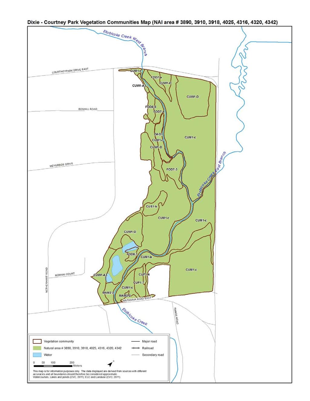
1 DIXIE - COURTNEYPARK 1 Region of Peel NAI Area # 3890, 3910, 3918, 4025, 4316, 4320, 4342 Toronto and Region Conservation Authority City of Mississauga Size: 49 hectares Watershed: Etobicoke Creek Con 4 E, Lots 6, 7; Con 5 E, Lots 6, 7 Subwatersheds: Lower Etobicoke Creek Ownership: 82% private, 18% public (City of Mississauga) General Summary This urban site consists of a section of vegetated Etobicoke Creek valley adjacent to the Toronto Pearson International Airport. It is comprised predominantly of cultural woodland and deciduous forest with the remainder of cultural meadow, cultural savannah and meadow marsh. The natural area is linear, riparian in focus and somewhat protected from human disturbance by virtue of being largely off-limits to the public. The area occupies a key position in maintaining a continuous vegetated corridor along Etobicoke Creek that allows wildlife movement. The area is undergoing succession from agricultural land use approximately 50 years ago and offers good habitat for grassland birds. TRCA ELC surveyors, botanists and ornithologists have provided complete data coverage for the core NAI inventories (vegetation communities, plant species, breeding birds) plus incidental observations of other fauna over the delineated area (Table 1). Currently, full species lists are not available however TRCA-tracked species and plant species that dominate vegetation communities are recorded here. Table 1: TRCA Field Visits Visit Date Inventory Type 29 Apr Fauna 06 June 2003 Fauna 09 June 2003 Fauna 07 July 2003 Fauna 10 July 2003 Fauna 12 Aug ELC, Flora 14 Aug ELC, Flora Physical Features This area is in the South Slope physiographic region; characterized by low-lying ground moraines. Soils of this region tend to be clay loams with pore sizes between soil particles so small that flow of groundwater to aquifers is slow. Etobicoke Creek has eroded a valley into the plain. The creek is the main hydrological feature of this site, as the area consists of the vegetated floodplain and valley walls between dividing roads. The creek takes its natural course, meandering across the floodplain between the valley walls. Human History The former community of Mt. Charles was located to the northwest of this natural area, at the crossroads of Dixie Rd. and Derry Rd. Derry Rd. was once a busy pioneer road linking the villages of Malton and Meadowvale. In 1819, Charles King Sr. was granted 100 acres of dense forest on the northeast corner of this intersection. He later purchased 100 acres on the southeast corner of this intersection where he operated a store and where his son later ran a post office (Wilkinson, Undated). Mt. Charles provided basic services to the surrounding agricultural community. A condition on land granting at that time was that the recipient had to clear acreage of trees and establish agriculture on
2 DIXIE - COURTNEYPARK 2 the granted land. Thus clearing of the lands in the neighbourhood of this natural area likely began in the early 1800 s (earlier than farther north in the region). The former agricultural community of Elmbank was located to the southeast, at the former intersection of Torbram Rd (5 th Line) and Britannia Rd. E. The community was displaced by airport expansion. Toronto Pearson International Airport lies adjacent to the east side of this natural area. It is Canada s largest and busiest airport. It began as Malton Airport in 1939, a small airport on 420 acres of former farmland between Derry Rd., Elmbank Sdrd., Airport Rd. and Torbram Rd. The original airport was northeast of this natural area. In the 1950 s the land that includes this natural area was expropriated to expand the airport, which became Toronto International Airport in 1960 (later renamed Toronto Pearson International Airport) (Archdiocese of Toronto, Undated; Greater Toronto Airports Authority, 2007; Wilkinson, 2009; Wyle, Undated). From this we can gather that by 1939 land use in the area was primarily agricultural and that by the 1950 s it was no longer under cultivation. Noise-related disturbance would have steadily increased as air traffic increased and runways were built closer to the natural area. The part of this natural area that is on airport-owned land is closed to the public and as such receives no direct human disturbance (such as trails, trampling, trash etc.). Some airport service roads, narrower and much less busy than city streets, run between several treed parts of the area although they should impose only a minimal impediment to wildlife movement. Although part of this area is on land owned by the City of Mississauga, the property is not developed as a park so public usage is minimal. To the west, at the top of the valley slope, there is adjacent industrial land use. To the south, a road borders the natural area. A road also borders the area at its north end, but natural habitat is continuous under a bridge that spans Etobicoke Creek. Vegetation Communities The general community types present here are deciduous forest (6%), meadow marsh (2%), open aquatic (4%), cultural meadow (69%), cultural savannah (2%), cultural woodland (16%) and plantation (2%). Twenty-five plant communities were mapped for this area, comprised of 13 different vegetation types, none of which are provincially rare (Table 2). All of the deciduous forest and cultural woodland communities are young to mid-aged. Table 2: ELC Vegetation Communities Map reference * Vegetation type Size in hectares % of natural area FOD6-5 Fresh-Moist Sugar Maple - Hardwood Deciduous Forest FOD7-3 Fresh-Moist Willow Lowland Deciduous Forest FOD7-A Fresh-Moist Manitoba Maple Lowland Deciduous Forest (2 communities) FOD8-1 Fresh-Moist Poplar Deciduous Forest MAM2-2 Reed Canary Grass Mineral Meadow Marsh (2 communities) OAO1 Open Aquatic Ecosite (deep or riverine) CUM1-b Exotic Cool-season Grass Old Field Meadow CUM1-C Exotic Forb Old Field Meadow (7 communities) CUS1-B Exotic Cultural Savannah CUW1-A3 Native Deciduous Cultural Woodland (2 communities) CUW1-D Hawthorn Cultural Woodland (4 communities)
3 DIXIE - COURTNEYPARK 3 CUP1-4 Hybrid Poplar Deciduous Plantation CUP1-7 Red (Green) Ash Deciduous Plantation TOTAL AREA INVENTORIED * Note: The map reference code refers to the vegetation type shown on mapping for this area and also to the Appendix list of species typically encountered in this vegetation type. Species Presence Vascular Plants At least 51 species of vascular plants occur at this site, of which 36 (71%) are native. Two of these are regionally rare (Table 4). Five of the plant species present here are TRCA regional Species of Conservation Concern and an additional 12 are TRCA regional Species of Urban Conservation Concern (Table 4). Breeding Birds At least 14 species of breeding birds occur at this site, all of which are native. One of these, Bobolink (Dolichonyx oryzivorus), is Threatened nationally and provincially (Table 3). Three of the bird species are TRCA regional Species of Conservation Concern and an additional ten are TRCA regional Species of Urban Conservation Concern. Two colonial-nesting bird species, Northern Rough-winged Swallow (Stelgidopteryx serripennis) and Green Heron (Butorides virescens), occupy this site. Four grassland species, Bobolink, Savannah Sparrow (Passerculus sandwichensis), Eastern Kingbird (Tyrannus tyrannus) and Willow Flycatcher (Empidonax traillii), nest at this site; of which two (Bobolink and Savannah Sparrow) are areasensitive. Herpetofauna One herpetofaunal species, American Toad (Bufo americanus), was recorded as an incidental observation at this site. It is native and a TRCA regional Species of Urban Conservation Concern. Mammals At least one species of mammal occurs at this site, detected as an incidental observation. It is native and considered to be a TRCA regional Species of Urban Conservation Concern. Other mammal species are likely present but targeted inventories would be required to detect them. Table 3: Designated Species At Risk Scientific name Common name COSEWIC COSSARO S rank G rank BIRDS Dolichonyx oryzivorus Bobolink THR THR S4B G5 Table 4: Regionally Rare Species (shown in bold), TRCA Regional Species of Conservation Concern (L1-L3), and TRCA Regional Species of Urban Conservation Concern (L4) (Kaiser, 2001; Toronto and Region Conservation Authority, 2007) Scientific name Common name S rank G rank L-rank VASCULAR PLANTS Acer saccharinum Silver Maple S5 G5 L4 Alnus incana ssp. rugosa Speckled Alder S5 G5T5 L3 Carpinus caroliniana American Hornbeam S5 G5 L4 Carya cordiformis Bitter-nut Hickory S5 G5 L4 Elymus riparius River Wild-rye S4? G5 L4 Fagus grandifolia American Beech S4 G5 L4 Iris versicolor Blue Flag S5 G5 L3
4 DIXIE - COURTNEYPARK 4 Physocarpus opulifolius Eastern Ninebark S5 G5 L3 Picea glauca White Spruce S5 G5 L3 Pinus strobus Eastern White Pine S5 G5 L4 Populus grandidentata Large-tooth Aspen S5 G5 L4 Rudbeckia hirta Black-eyed Susan S5 G5 L4 Schoenoplectus tabernaemontani Soft-stem Bulrush S5 G5 L4 Scirpus microcarpus Red-tinge Bulrush S5 G5 L4 Sparganium eurycarpum Large Bur-reed S5 G5 L3 Spiraea alba Narrow-leaved Meadowsweet S5 G5 L4 Thuja occidentalis Eastern White Cedar S5 G5 L4 BIRDS Scolopax minor American Woodcock S4B G5 L3 Ceryle alcyon Belted Kingfisher S4B G5 L4 Coccyzus erythropthalmus Black-billed Cuckoo S5B G5 L3 Dolichonyx oryzivorus Bobolink S4B G5 L3 Geothlypis trichas Common Yellowthroat S5B G5 L4 Tyrannus tyrannus Eastern Kingbird S5B G5 L4 Dumetella carolinensis Gray Catbird S5B G5 L4 Butorides virescens Green Heron S4B G5 L4 Colaptes auratus Northern Flicker S4B G5 L4 Northern Rough-winged Swallow S4B G5 L4 Stelgidopteryx serripennis Passerculus sandwichensis Savannah Sparrow S4B G5 L4 Actitis macularia Spotted Sandpiper S5B G5 L4 Empidonax traillii Willow Flycatcher S5B G5 L4 HERPETOFAUNA Bufo americanus American Toad S5 G5 L4 MAMMALS Odocoileus virginianus White-tailed Deer S5 G5 L4 Site Condition and Disturbances This urban natural area is unlike other urban areas in this report in that it is disturbed by industrial use (including an airport) rather than residential use. Natural areas with nearby residential use tend to be disturbed from recreational use. However, in this case, the industrial usage bars it from recreational use. Birds nesting in this area experience much greater levels of noise than those in other urban areas. However, some bird species can adapt to aircraft noise. TRCA compared bird diversity on the airport lands with that along the Etobicoke Creek valley between the airport and Lake Ontario. Bird diversity was in fact higher on the airport lands that were noisier and more historically disturbed, than it was in the intact natural areas away from the airport. It is believed that this difference is due to the closure of airport lands to the public and the resulting lack of direct human disturbance. It suggests both that local birds can adapt to airport noise and also that disturbances caused by the presence of people in natural areas may be underestimated (R. Krick, pers. comm., 2010). This site is regenerating from the historical loss of forest cover (over 150 years ago), and subsequent agricultural impacts. As such, young to mid-aged successional communities are represented.
5 DIXIE - COURTNEYPARK 5 Three of the woodland and forest communities have light to moderate logging disturbance. Communities along the Etobicoke Creek floodplain sustain light flooding. The maintenance of the natural river course with meanders helps to mitigate against flooding. Trash is generally light but is moderate and severe respectively in the two native deciduous cultural woodland communities from people dumping refuse out of sight over the valley edges. Light earth displacement is evident in two cultural woodland communities. Disturbance by exotics ranges from light to severe with moderate disturbance being the norm. Ecological Features and Functions With wetlands over 0.5 ha in size and extensive adjacent and included cultural meadows over 10 ha, this natural area has the potential to support and sustain biodiversity, healthy ecosystem functions and to provide long-term resilience for the natural system. The riparian area provides a transitional zone between terrestrial and aquatic habitats, helping to maintain the water quality of the river and providing a movement corridor for plants and wildlife. By containing a relatively wide variety of habitat types, this natural area supports biodiversity, particularly for species that require more than one habitat type for their life needs. The narrow, naturally vegetated valley of Etobicoke Creek extends both upstream and downstream from this site. Connectivity is generally good in this immediate area. Roads divide this from upstream and downstream areas but these roads terminate at the airport lands and are thus not as busy and dangerous for wildlife as other city roads are. Upstream, a bridge spanning the creek allows for continuous natural habitat under the bridge. The relatively close proximity of other areas of natural habitat creates above-average potential for wildlife movement between natural areas, species dispersal and recovery from disturbance, creating additional resilience for the ecosystem. Etobicoke Creek runs through this area and thus this natural area supports the connectivity function of this watercourse and its tributaries by providing a natural habitat corridor that facilitates the crossregional movement of wildlife along this corridor between major provincial corridors. This natural area supports one bird Species At Risk and two regionally rare plant species. This site supports two colonial-nesting bird species and four grassland bird species of which two are area-sensitive. Based on the above features, this area should be evaluated to determine if significant wildlife habitat is present in accordance with the Provincial Policy Statement, Region of Peel Official Plan, and area municipal Official Plan. Opportunities Existing linkages to other natural areas upstream and downstream of this site should be maintained, as this area occupies a key position in providing a vegetated and natural corridor that promotes wildlife movement along the south part of Etobicoke Creek. While a variety of ways to increase the suitability of this area for wildlife, and to increase biodiversity and species abundances could be suggested, it is also important to keep in mind that increased wildlife use of this area could run counter to the safe operation of the airport. Concerns already exist about adjacent land uses that may increase wildlife (especially bird) activity and wildlife collisions with planes that would endanger air traffic. Additional inventories of herpetofauna, dragonflies/damselflies, butterflies and mammals may be productive given the presence of the river and habitat types both in this area and adjacent to it.
6 DIXIE - COURTNEYPARK 6 Literature Cited Archdiocese of Toronto. Undated. The Elmbank/Fifth Line Mission History. Available at Last Accessed 23 November Greater Toronto Airports Authority Toronto Pearson Today. Available at Last Accessed 6 April 6, Kaiser, Jeff The Vascular Plant Flora of the Region of Peel and the Credit River Watershed. Prepared for: Credit Valley Conservation, the Regional Municipality of Peel, Toronto and Region Conservation Authority. Toronto and Region Conservation Authority Terrestrial Natural Heritage Program Data Collection Methodology. Wilkinson, M. Undated. Preserving Our Places. Available at Last Accessed 23 November Wilkinson, M The Lost Village of Elmbank. Available at Last Accessed 23 November Wyle. Undated. Noise Basics and the Effect of Aviation Noise on the Environment. Available at Last Accessed 16 December 2010.
7 DIXIE - COURTNEYPARK 7
8 DIXIE - COURTNEYPARK 8
DIXIE HIGHWAY Region of Peel NAI Area # 1304, 1320, 2449, 2625, 3961
 DIXIE HIGHWAY 407 1 Region of Peel NAI Area # 1304, 1320, 2449, 2625, 3961 Toronto and Region Conservation Authority City of Brampton Size: 36 hectares Watershed: Etobicoke Creek Con 4 E, Lots 13, 14 Ownership:
DIXIE LAKESHORE 1 (MARIE CURTIS PARK & AREA)
") DIXIE LAKESHORE 1 Region of Peel NAI Area # 3524, 3526, 4177 Toronto and Region Conservation Authority; Credit Valley Conservation City of Mississauga Size: 36 hectares Watershed: Etobicoke Creek; Lake
DIXIE LAKESHORE 1 Region of Peel NAI Area # 3524, 3526, 4177 Toronto and Region Conservation Authority; Credit Valley Conservation City of Mississauga Size: 36 hectares Watershed: Etobicoke Creek; Lake
HURONTARIO - MAYFIELD 1
 HURONTARIO - MAYFIELD 1 Region of Peel NAI Area # 2075, 2088, 2089, 2096, 2495, 2634 Toronto and Region Conservation Authority City of Brampton Size: 42 hectares Watershed: Etobicoke Creek Con 1 E, Lots
3.0 EXISTING PARK & RECREATION SPACE
 3.0 EXISTING PARK & RECREATION SPACE TOWN PARK & RECREATION SPACE An inventory of current parks and recreation area in the Town of Cedarburg is shown in Table 3. These areas total roughly 381.89 acres.
Whitemouth Falls Provincial Park. Draft Management Plan
 Whitemouth Falls Provincial Park Draft Management Plan Whitemouth Falls Provincial Park Draft Management Plan Table of Contents 1. Introduction... 3 2. Park History... 3 3. Park Attributes... 4 3.1 Natural...
OPG, Nuclear 2
 B iodiversity Assessment Building a Biodiversity Management Plan November 24, 2011 OPG, Nuclear 2 Biodiversity Assessment What habitat, or your site? potential habitat, is available on What species of
HEART LAKE - ESCARPMENT CENTRAL 1
 HEART LAKE - ESCARPMENT CENTRAL 1 Region of Peel NAI Area # 9593 Credit Valley Conservation Authority Town of Caledon Size: 155 hectares Watershed: Credit River Con 3 EHS, Lots 6-9 Ownership: 100% private
SIXTH LINE - HIGHWAY 7 1
 SIXTH LINE - HIGHWAY 7 1 Region of Halton NAI Area # 7409 Credit Valley Conservation Authority Town of Halton Hills Size: 202 hectares Watershed: Credit River Con 7, Lots 23-27 Ownership: 92% private,
2.0 Physical Characteristics
 _ 2.0 Physical Characteristics 2.1 Existing Land Use for the Project The site is comprised of approximately 114 acres bounded by Highway 101 to the north, the existing town of Los Alamos to the east, State
Pinawa Provincial Park. Draft Management Plan
 Pinawa Provincial Park Draft Management Plan Pinawa Provincial Park Draft Management Plan Table of Contents 1. Introduction... 3 2. Park History... 3 3. Park Attributes... 4 3.1 Natural... 4 3.2 Recreational...
Birch Point Provincial Park. Management Plan
 Birch Point Provincial Park Management Plan 2 Birch Point Provincial Park Table of Contents 1. Introduction... 3 2. Park History... 3 3. Park Attributes... 4 3.1 Natural... 4 3.2 Recreational... 4 4. Park
BLIND LINE - HOCKLEY 1 (MONORA PARK AND AREA)
") BLIND LINE - HOCKLEY 1 Dufferin County NAI Area # 264 Credit Valley Conservation Authority Town of Mono Size: 79 hectares Watershed: Credit River Con 2 WHS, Lots 4-5 Ownership: 31% private, 69% public
BLIND LINE - HOCKLEY 1 Dufferin County NAI Area # 264 Credit Valley Conservation Authority Town of Mono Size: 79 hectares Watershed: Credit River Con 2 WHS, Lots 4-5 Ownership: 31% private, 69% public
MISSISSAUGA RD - KING 1
 MISSISSAUGA RD - KING 1 Region of Peel NAI Area # 9568 Toronto and Region Conservation Authority Town of Caledon Size: 128 hectares Watershed: Etobicoke Creek Con 4 WHS, Lots 23-27 Ownership: 100% private
Green Legacy. Securing our. Greenlands Strategy
 Greenlands Strategy Securing our Green Legacy Together we can create an interconnected network of Greenlands for the health and well-being of the environment and future generations Caring for the Credit
Oak Ridges Corridor Park East Management Plan
 Oak Ridges Corridor Park East Management Plan August 2011 Prepared by: Oak Ridges Corridor Park East Technical Steering Committee Oak Ridges Corridor Park East Public Advisory Committee Conservation Lands
Rouge National Park. Opportunities and Challenges
 Rouge National Park Opportunities and Challenges January 2013 Rouge Park Finch Meander Rouge Beach at Lake Ontario Toronto GLWQA Area of Concern Rouge National Park Nationally Significant First Nation
Pembina Valley Provincial Park. Draft Management Plan
 Pembina Valley Provincial Park Draft Management Plan 2 Pembina Valley Provincial Park Table of Contents 1. Introduction... 3 2. Park History... 3 3. Park Attributes... 3 3.1 Natural... 3 3.2 Recreational...
Summary of prescribed fires in Prince Albert National Park 2015
 Summary of prescribed fires in Prince Albert National Park 2015 Prince Albert National Park conducted four controlled fires in spring 2015, plus an additional fire in October. Fuel Management for Hazard
GOREWAY QUEEN 1 (PART OF CLAIREVILLE CA)
") GOREWAY QUEEN 1 Region of Peel NAI Area # 2121, 2136, 2142, 2145, 2147, 2148, 2154, 2165, 2170, 2175, 2179, 2369, 2521, 2637, 2639, 2641 Toronto and Region Conservation Authority City of Brampton Size:
GOREWAY QUEEN 1 Region of Peel NAI Area # 2121, 2136, 2142, 2145, 2147, 2148, 2154, 2165, 2170, 2175, 2179, 2369, 2521, 2637, 2639, 2641 Toronto and Region Conservation Authority City of Brampton Size:
Seager Wheeler Lake. Representative Area. -- Concept Management Plan --
 Seager Wheeler Lake Representative Area -- Concept Management Plan -- Saskatchewan Environment and Resource Management January, 1999 Saskatchewan s Representative Areas Network Program The Government of
The Design of Nature Reserves
 The Design of Nature Reserves Goals Maintenance of MVP s for targeted species Maintenance of intact communities Minimization of disease Considerations of reserve design 1. Disturbance regime Fire Insect
Watchorn Provincial Park. Management Plan
 Watchorn Provincial Park Management Plan 2 Watchorn Provincial Park Table of Contents 1. Introduction... 3 2. Park History... 3 3. Park Attributes... 3 3.1 Natural... 4 3.2 Recreational... 4 3.3 Additional
Pinellas County Environmental Lands
 Pinellas County Environmental Lands In addition to traditional parks and recreation facilities, Pinellas County owns and manages a system of environmental lands that provides specialized resource-based
Resource Management Tract Management Plan. May, 2015 PHOTO NEEDED. Cover photo credit: Barry Westhead
 PHOTO NEEDED Resource Management Tract Management Plan May, 2015 A Cover photo credit: Barry Westhead 1.0 INTRODUCTION TABLE OF CONTENTS AUTHORITY RESOLUTION At Authority Meeting #6/14, held on July 25,
HAROLD E. ALEXANDER SPRING RIVER WILDLIFE MANAGEMENT AREA
 HAROLD E. ALEXANDER SPRING RIVER WILDLIFE MANAGEMENT AREA HAROLD E. ALEXANDER SPRING RIVER WILDLIFE MANAGEMENT AREA Prepared by: Randy Brents Jr (Fire Management Officer) Dallas Harrell (Area Biologist)
Clearwater Lake Provincial Park. Draft Management Plan
 Clearwater Lake Provincial Park Draft Management Plan Clearwater Lake Provincial Park Draft Management Plan Table of Contents 1. Introduction... 3 2. Park History... 4 3. Park Attributes... 4 3.1 Location/Access...4
Conservation Area Management Statement
 Conservation Area Management Statement Miller Creek Wildlife Area Resolution #: Approval: Issue Date: Date of Last Revision: Table of Contents 1. Purpose....... 1 2. Property Description...... 1 2.1. Legal
STREAKED HORNED LARK. Conservation of a threatened species in an industrial landscape. Cat Brown US Fish and Wildlife Service
 STREAKED HORNED LARK Conservation of a threatened species in an industrial landscape Cat Brown US Fish and Wildlife Service HISTORICAL & CURRENT RANGE Streaked Horned Lark Distribution Historical Range:
Wetlands Reservoirs of Biodiversity. Billy McCord, SCDNR
 Wetlands Reservoirs of Biodiversity Billy McCord, SCDNR Estuaries Tidal Deepwater Intertidal Salt Marsh Tidal Riverine Fresh & Brackish Deepwater Tidal Emergent Marsh Freshwater Riverine Seasonally Flooded
2.0 PARK VISION AND ROLES
 2.0 PARK VISION AND ROLES 2.1 Significance in the Protected Area System Marble Range and Edge Hills provincial parks protect 6.8% of the Pavillion Ranges Ecosection, which is located in the Southern Interior
MT. PLEASANT BRUNO RIDGE 1
 MT. PLEASANT BRUNO RIDGE 1 Region of Peel NAI Area # 9648 Toronto and Region Conservation Authority Town of Caledon Size: 93 hectares Watershed: Humber River Con 9, Lots 15-19 Ownership: 100 % private
David Magney Environmental Consulting
 David Magney Environmental Consulting DELINEATION OF JURISDICTIONAL WATERS AND RIPARIAN HABITATS FOR LYONS CANYON RANCH, NEWHALL, CALIFORNIA Prepared for: UNITED STATES ARMY CORPS OF ENGINEERS and CALIFORNIA
ALBERTA S GRASSLANDS IN CONTEXT
 ALBERTA S GRASSLANDS IN CONTEXT GLOBAL GRASSLANDS 1 Temperate grasslands, located north of the Tropic of Cancer and south of the Tropic of Capricorn, are one of the world s great terrestrial biomes 2.
PROPOSED QUARRY FOOTPRINT PHASE 2 PHASE 3. PHASE 5 West. PHASE 5 East. PHASE 6 West. PHASE 6 East PHASE 7 PHASE 4 PHASE 1
 PHASE 4 \\Cd1220-f02\01609\active\2001 Active Projects\1100-1199\G1188\graphics\GIS\MXD\_Final Draft Sept 2008\MXD\Section_5\62601188_Fig5-0_ProposedQuarryFootprint_01Dec08_NJB.mxd PHASE 7 PHASE 5 West
Geoscape Toronto The Oak Ridges Moraine Activity 2 - Page 1 of 10 Information Bulletin
 About 13,000 years ago as the Laurentide Ice Sheet melted, glacial meltwater accumulated between the ice sheet and the Niagara Escarpment. This formed a lake basin into which gravel and sand were deposited.
Significant Natural Area Assessment. Property Name: Hillend Station
 Private Bag 50072, Queenstown 9348, New Zealand QUEENSTOWN, 10 Gorge Road, Phone +64 3 441 0499, Fax +64 3 450 2223 WANAKA, 47 Ardmore Street, Phone +64 3 443 0024, Fax +64 3 450 2223 Significant Natural
Yard Creek Provincial Park. Management Plan
 Yard Creek Provincial Park Management Plan Draft January 2010 Yard Creek Provincial Park Management Plan Approved by: telàlsemkin/siyam/chief Scott Benton Bill Williams Squamish Executive Director ation
Appendix 1: Best Management Practices For Hang Gliding and Paragliding in Jasper National Parks
 Appendix 1: Best Management Practices For Hang Gliding and Paragliding in Jasper National Parks Name of Best Management Practice Best Management Practices for Hang Gliding and Paragliding in Jasper National
Marchand Provincial Park. Management Plan
 Marchand Provincial Park Management Plan 2 Marchand Provincial Park Table of Contents 1. Introduction... 3 2. Park History... 3 3. Park Attributes... 4 3.1 Natural... 4 3.2 Recreational... 4 3.3 Additional
IOWA ORNITHOLOGISTS' UNION - Birding Sites in Dallas County
 IOWA ORNITHOLOGISTS' UNION - Birding Sites in Dallas County Printed on 7/19/2018 Beaver Bottoms Wetland (restricted) (Important Bird Area) GPS Coordinates:, Ownership: Private (see directions for access)
HIGHWAY 10 5 SIDEROAD MONO (ISLAND LAKE AND AREA)
") 1 Dufferin County NAI Area # 203, 210, 219, 227, 228, 239, 242, 256, 265, 267, 268, 276, 279, 308, 403, 419, 498, 503, 515, Town of Mono; Size: 428 hectares Town of Orangeville Con 1 WHS, Lots 1-5; Con
1 Dufferin County NAI Area # 203, 210, 219, 227, 228, 239, 242, 256, 265, 267, 268, 276, 279, 308, 403, 419, 498, 503, 515, Town of Mono; Size: 428 hectares Town of Orangeville Con 1 WHS, Lots 1-5; Con
Preparing Baseline Documentation for your Protected Lands
 Preparing Baseline Documentation for your Protected Lands December 7, 2013 William Hall Free Library Cranston, RI Carol Lynn Trocki, Conservation Biologist Sponsored by Rhode Island Land Trust Council
Evaluation of Outstanding Remarkable Values for Collawash River March 2011
 Evaluation of Outstanding Remarkable Values for Collawash River March 0 Segment From headwaters of East Fork Collawash River to Buckeye Creek Mileage: miles Free flowing: Yes Scenic:, Substantial River
AMENDMENT NO. 03 TO THE OFFICIAL PLAN FOR THE TOWNSHIP OF ADJALA-TOSORONTIO OAK RIDGES MORAINE CONSERVATION PLAN
 AMENDMENT NO. 03 TO THE OFFICIAL PLAN FOR THE TOWNSHIP OF ADJALA-TOSORONTIO OAK RIDGES MORAINE CONSERVATION PLAN Adopted by Council July 19 th, 2004 Approved with modifications by the Province of Ontario
Bayview Escarpment. Interim Management Statement
 Bayview Escarpment Interim Management Statement Bayview Escarpment Provincial Nature Reserve Interim Management Statement January 15, 1995 REGIONAL DIRECTOR'S APPROVAL STATEMENT This Interim Management
Hudson Bay Lowlands Proposed Protected Areas
 Hudson Bay Lowlands Proposed Protected Areas Hudson Bay Lowlands Proposed Protected Areas The Protected Areas Initiative has identified portions of the Hudson Bay Lowlands region that have significant
 March 25, 1994 To: Re: MEMO TO FILE MINOR AMENDMENT - PINERY PROVINCIAL PARK MANAGEMENT PLAN The following paragraph from page 5 of the Pinery Provincial Park Management Plan (ISBN 0-7729-0290-9) lnsects
DECISION MEMO. Rawhide Trail #7073 Maintenance and Reconstruction
 Page 1 of 6 Background DECISION MEMO USDA Forest Service Jefferson Ranger District Jefferson County, Montana Rawhide Trail #7073 is located in the Elkhorn Mountain Range approximately 10 miles east of
Blanco Creek Ranch Acres, Uvalde County, Texas
 Blanco Creek Ranch 1208.30 Acres, Uvalde County, Texas James King, Agent Office 432 426.2024 Cell 432 386.2821 James@KingLandWater.com Blanco Creek Ranch 1208.30 acres Uvalde County, Texas James King,
KETTLE CREEK CONSERVATION AUTHORITY TRAIL GUIDE.
 KETTLE CREEK CONSERVATION AUTHORITY TRAIL GUIDE www.kettlecreekconservation.on.ca EXPLORE OUR TRAILS HIKE OUR TRAILS Kettle Creek Conservation Authority (KCCA) proudly supports and promotes an active lifestyle
ETOBICOKE CREEK NORTH TRAIL PROJECT. May 18, 2017 at Michael Power High School 105 Eringate Drive, Etobicoke ON M9C 3Z7
 ETOBICOKE CREEK NORTH TRAIL PROJECT May 18, 2017 at Michael Power High School 105 Eringate Drive, Etobicoke ON M9C 3Z7 1 Purpose of Open House The purpose of today s open house is to present the design
Item 4. Agency Correspondence. U.S. Army Corps of Engineers Jurisdictional Determination. Ohio Department of Natural Resources
 Item 4 Agency Correspondence U.S. Army Corps of Engineers Jurisdictional Determination Ohio Department of Natural Resources U.S. Fish and Wildlife Service Office of Real Estate Paul R.
IV International Symposium Agrosym /AGSY M NATURAL RESOURCES AND THE ENVIRONMENT OF UPPER DANUBE
 10.7251/AGSY1303899M NATURAL RESOURCES AND THE ENVIRONMENT OF UPPER DANUBE Nada MIJAJLOVIC*, Vesna POPOVIC, Jonel SUBIC Institute of Agricultural Economics, Belgrade, Serbia *(Corresponding author: nada_m@iep.bg.ac.rs)
Alternative 3 Prohibit Road Construction, Reconstruction, and Timber Harvest Except for Stewardship Purposes B Within Inventoried Roadless Areas
 Roadless Area Conservation FEIS Summary Table S-1. Comparison of Key Characteristics and Effects by Prohibition Alternative. The effects summarized in this table A would occur in inventoried roadless areas
Habitat Assessment, Mt San Jacinto CCD/MSJC Southwest Campus
 I - 15 CORRIDOR CAMPUS MASTER PLAN DRAFT EIR MT. SAN JACINTO COMMUNITY COLLEGE DISTRICT Appendices Appendix D7 Habitat Assessment, Mt San Jacinto CCD/MSJC Southwest Campus August 2017 I - 15 CORRIDOR CAMPUS
Wallace Lake Provincial Park. Management Plan
 Wallace Lake Provincial Park Management Plan 2 Wallace Lake Provincial Park Table of Contents 1. Introduction... 3 2. Park History... 3 3. Park Attributes... 4 3.1 Natural... 4 3.2 Recreational... 4 4.
Daisy Dean Trail 628/619 ATV Trail Construction
 Background and Purpose and Need The Daisy Dean ATV Trail Construction Project is located in the Little Belt Mountains, Musselshell Ranger District, Lewis and Clark National Forest approximately 32 miles
Sasagiu Rapids Provincial Park. Draft Management Plan
 Sasagiu Rapids Provincial Park Draft Management Plan 2 Sasagiu Rapids Provincial Park Table of Contents 1. Introduction... 3 2. Background and Park Attributes... 3 2.1 Park History.... 3 2.2 Natural Features...
Terrestrial Protected Area Nomination: Central Mangrove Wetland South-West, Grand Cayman
 Terrestrial Protected Area Nomination: Central Mangrove Wetland South-West, Grand Cayman The attached nomination, proposing that a parcel of land in the Central Mangrove Wetland be made a Protected Area
South Atikaki Provincial Park. Draft Management Plan
 South Atikaki Provincial Park Draft Management Plan South Atikaki Provincial Park Draft Management Plan Table of Contents 1. Introduction... 3 2. Park History... 3 3. Park Attributes... 3 3.1 Natural...
Summary of Characteristics that Qualify Sites as ESAs (Source: Environmentally Significant Areas in the City of Toronto, June 2012, Appendix 2)
") Summary of Characteristics that Qualify s as ESAs (Source: Environmentally Significant Areas in the City of Toronto, June 2012, Appendix 2) Name Description Area 1 1 Barkey Woods mature upland deciduous
Summary of Characteristics that Qualify s as ESAs (Source: Environmentally Significant Areas in the City of Toronto, June 2012, Appendix 2) Name Description Area 1 1 Barkey Woods mature upland deciduous
County of Riverside - PSEC Project General Habitat Assessment Appendix A
 County of Riverside - PSEC Project General Habitat Assessment Appendix A Lake Elsinore Lake Elsinore The Lake Elsinore study area is located in the hills directly adjacent to Lake Elsinore, in the City
Ep156 Miller's Grove (2.3 ha) TL
 TL") Ep156 Miller's Grove (2.3 ha) TL 520040 Miller's Grove is located just within the extreme eastern boundary of Ongar Great Park, a medieval deer park dating from the 11 th century. This broadleaved woodland
Ep156 Miller's Grove (2.3 ha) TL 520040 Miller's Grove is located just within the extreme eastern boundary of Ongar Great Park, a medieval deer park dating from the 11 th century. This broadleaved woodland
THOMAS A. SWIFT METROPARK Introductions History Present Conditions Future Development Plans Implementation Strategies Statistics
 THOMAS A. SWIFT METROPARK Introductions History Present Conditions Future Development Plans Implementation Strategies Statistics Introduction As an open meadow park positioned along the Mahoning River,
MANAGEMENT DIRECTION STATEMENT June, 1999
 Thompson River District MANAGEMENT DIRECTION STATEMENT June, 1999 for Clearwater River Corridor (Addition to Wells Gray Park) Ministry of Environment Lands and Parks BC Parks Division ii Table of Contents
Wallace Lake Provincial Park. Draft Management Plan
 Wallace Lake Provincial Park Draft Management Plan Wallace Lake Provincial Park Draft Management Plan Table of Contents 1. Introduction... 3 2. Park History... 3 3. Park Attributes... 4 3.1 Natural...
Recreational Carrying Capacity
 9 th Annual Caribbean Sustainable Tourism Conference Recreational Carrying Capacity Graham C Barrow What is Recreational Carrying Capacity? It s not about fixing absolute numbers of visitors/tourists that
Wetland of Lakes Koronia and Volvi, by Themis Nasopoulou Ramsar Wetland of Lakes Koronia and Volvi
 Preliminary hour by- hour Schedule By Themis Nasopoulou Ecoguide-Journalist MSc Biological Diversity E-mail: nasthem1@hotmail.com Mob.tel.: 0030-6937122299 Ramsar Wetland of Lakes Koronia and Volvi Litohoro
The following criteria were used to identify Benchmark Areas:
 7.0 BENCHMARK AREAS The Churn Creek Protected Area offers a significant opportunity to learn more about how grassland ecosystems function. One of the key tools that will be used to monitor larger grassland
STORNETTA BROTHERS COASTAL RANCH
 STORNETTA BROTHERS COASTAL RANCH Location: Surrounding Point Arena Lighthouse and immediately south of Manchester State Park Mendocino Co., CA Acres: 1,860 Resources: Over two miles of Pacific Ocean coastline
EAST DON TRAIL ENVIRONMENTAL ASSESSMENT. Community Liaison Committee Meeting #3 July 15, :30 to 8:30 pm Flemingdon Park Library
 EAST DON TRAIL ENVIRONMENTAL ASSESSMENT Community Liaison Committee Meeting #3 July 15, 2013 6:30 to 8:30 pm Flemingdon Park Library Agenda 1. Welcome 2. Housekeeping and Updates a) Housekeeping b) CLC
Town of Oakfield Agricultural and Farmland Protection Plan
 SECTION III COMMUNITY OVERVIEW A. Regional Setting / Location The Town of Oakfield is located in the northwestern portion of Genesee County. Located west of New York's Finger Lakes, the Town is uniquely
APPENDIX F List of Commitments
 APPENDIX F List of Commitments s Table F.1 Standard Mitigation Measures Mitigation Measure MnDOT Specification Number Status Update Description Status Update Utilities Provide early notice to utility operators
Amendment 41 to the Official Plan for the Regional Municipality of York
 Attachment 3 Council Report Attachment Amendment 41 to the Official Plan for the Regional Municipality of York As approved by the Minister of Municipal Affairs and Housing October 21, 2004 Deferred policies
ANAGEMENT. LAN November, 1996
 M ANAGEMENT P LAN November, 1996 for Paul Lake Provincial Park Ministry of Environment, Lands and Parks BC Parks Department Paul Lake Provincial Park M ANAGEMENT P LAN Prepared by BC Parks Kamloops Area
Potomac Gorge. Resource Booklet. A Natural Monument in the Shadow of National Monuments. Bridging the Watershed. Potomac Gorge 75
 Potomac Gorge Potomac Gorge A Natural Monument in the Shadow of National Monuments Resource Booklet Bridging the Watershed An outreach program of the Alice Ferguson Foundation in partnership with the National
FEASIBILITY CRITERIA
 This chapter describes the methodology and criteria used to evaluate the feasibility of developing trails throughout the study areas. Land availability, habitat sensitivity, roadway crossings and on-street
OMINEACA PROVINCIAL PARK
 OMINEACA PROVINCIAL PARK AND PROTECTED AREA PURPOSE STATEMENT AND ZONING PLAN March 2003 OMINECA PROVINCIAL PARK AND PROTECTED AREA Purpose Statement and Zoning Plan Omineca Park and Omineca Protected
Phoenix Habitat Restoration Projects
 Phoenix Habitat Restoration Projects Spur Cross Ranch Cave Creek (Estergard) Regional Tree and Shade Summit March 9, 2010 Desert Riparian Ecosystems Healthy riparian areas like this once existed along
Terrestrial Protected Area Nomination: Hemmington Forest, Cayman Brac Central
 Terrestrial Protected Area Nomination: Hemmington Forest, Cayman Brac Central Initial discussions with major landowners in the Hemmington Forest area have indicated that a nomination to protect some or
Lynde Creek Watershed. Lynde Creek Watershed CLOCA LYNDE CREEK WATERSHED EXISTING CONDITIONS REPORT CHAPTER 1 STUDY AREA
 Lynde Creek Watershed CLOCA Lynde Creek Watershed CLOCA LYNDE CREEK WATERSHED EXISTING CONDITIONS REPORT CHAPTER 1 STUDY AREA June 2008 TABLE OF CONTENTS 1.0 STUDY AREA... 3 1.1 Lynde Main Subwatershed...6
Te Manahuna Consulting
 Assessment of the natural values at the proposed centre pivot irrigation site and surrounds on Ben Ohau Station, Mackenzie Basin, New Zealand August 2016 Abstract The natural values of the area proposed
Sawtooth National Forest Fairfield Ranger District
 United States Department of Agriculture Forest Service Sawtooth National Forest Fairfield Ranger District P.O. Box 189 Fairfield, ID. 83327 208-764-3202 Fax: 208-764-3211 File Code: 1950/7700 Date: December
White Mountain National Forest Saco Ranger District
 United States Department of Agriculture Forest Service White Mountain National Forest Saco Ranger District 33 Kancamagus Highway Conway, NH 03818 Comm: (603) 447-5448 TTY: (603) 447-3121 File Code: 1950
BRACEVILLE NATURE PRESERVE Introductions History Present Conditions Future Development Plans Implementation Strategies Statistics
 BRACEVILLE NATURE PRESERVE Introductions History Present Conditions Future Development Plans Implementation Strategies Statistics Introduction Braceville Nature Preserve is one of MetroParks largest preserves.
County of Riverside - PSEC Project General Habitat Assessment Appendix A
 County of Riverside - PSEC Project General Habitat Assessment Appendix A Glen Avon Glen Avon The Glen Avon study area is located north of State Route 60 in the Jurupa Mountains, approximately 1 mile south
Pasquia-Porcupine. Representative Areas. -- Concept Management Plan --
 Pasquia-Porcupine Representative Areas -- Concept Management Plan -- Saskatchewan Environment June, 2004 Pasquia/Porcupine Integrated Forest Land Use Plan The Pasquia/Porcupine Integrated Forest Land Use
National Forests and Grasslands in Texas
 United States Department of Agriculture Forest Service National Forests and Grasslands in Texas Sam Houston NF 394 FM 1375 West New Waverly, Texas 77358 Phone 936-344-6205 Dear Friends, File Code: 1950
Figure 1 shows the evaluation area around Tailings Basin Cells 2E/1E. Two areas were evaluated for potential wetland impacts including:
 Barr Engineering Company 4700 West 77th Street Minneapolis, MN 55435-4803 Phone: 952-832-2600 Fax: 952-832-2601 www.barr.com An EEO Employer Minneapolis, MN Hibbing, MN Duluth, MN Ann Arbor, MI Jefferson
ONE ISLAND LAKE PROVINCIAL PARK Purpose Statement and Zoning Plan
 ONE ISLAND LAKE PROVINCIAL PARK Purpose Statement and Zoning Plan Primary Role The primary role of One Island Lake Provincial Park is to provide recreational opportunities to regional and residential area
Spatial Distribution and Characteristics of At-Risk Species in the Southeast U.S.
 Nicholas Institute for Environmental Policy Solutions Scoping Document Part 2 Exploratory Analysis of Characteristics and Trends of At-Risk Species in the Southeast U.S. Spatial Distribution and Characteristics
DOYLE SPRINGS PLANNING UNIT Kern-Tule River Watershed
 Existing Conditions & Uses Overview Consists of a mostly forested parcel with small hydropower developments and part of a private recreation cabin development, along with two small transmission line corridor
Map 1.1 Wenatchee Watershed Land Ownership
 Map 1.1 Wenatchee Watershed Land Ownership Map 1.1 Wenatchee Watershed Land Ownership The Wenatchee watershed lies in the heart of Washington state in Chelan County. Just larger than the state of Rhode
155 acres on Tyaughton Lake 900 feet of Pristine Waterfront Private & Secluded Property
 155 acres on Tyaughton Lake 900 feet of Pristine Waterfront Private & Secluded Property 946 Tyaughton Lake Road Gold Bridge BC V0K1P0 900 ft of waterfront with 155 acres of south facing easy access. This
Decision Memo Broken Wheel Ranch Equestrian Outfitter Special-Use Permit Proposed Action
 Decision Memo Broken Wheel Ranch Equestrian Outfitter Special-Use Permit USDA Forest Service Mississippi Bluffs Ranger District, Shawnee National Forest Jackson and Union Counties, Illinois Proposed Action
SITE NE9 NE9 NE NATURAL AREAS UPDATE CUM1-1 FOD7-3 FOD7-3 FOD4 CUM1-1 FOD4. Anthropogenic CUM1-1 FOD4. Manicured CUM1-1 FOD1-2 CUM1-1 MAS2-1
 DERRY ROAD EAST NE9 Anthropogenic NE9 GOREW AY DRIVE Manicured C.N.R. FOD1-2 MIMICO MAS2-1 FOD1-2 CREEK CUS1-1 MAS2-1 CUS1-1 CUS1-1 NE9 HIGHW AY No. 427 CITY OF TORONTO NATURAL AREAS SYSTEM CLASSIFICATION
Brooker Creek Preserve Management Plan 2008 Update
 Brooker Creek Preserve Management Plan 2008 Update Plan approved by the Board of County Commissioners Pinellas County, Florida 19 August 2008 Pinellas County Department of Environmental Management Environmental
SANTA-BOCA PROVINCIAL PARK
 SANTA-BOCA PROVINCIAL PARK PURPOSE STATEMENT AND ZONING PLAN March 2003 SANTA-BOCA PROVINCIAL PARK Purpose Statement and Zoning Plan Primary Role The primary role of Santa-Boca Park is to provide marine-based
Cuyahoga Valley National Park Ohio
 Cuyahoga Valley National Park Ohio Brandywine Falls The Ledges The Beaver Marsh Temperate Deciduous Forest How To Get There... Located between Cleveland & Akron, Ohio Cuyahoga Valley National Park can
MANAGEMENT DIRECTION STATEMENT June, 1999
 Garibaldi/Sunshine Coast District MAAGEMET DIRECTIO STATEMET June, 1999 for Homathko Estuary Provincial Park Ministry of Environment Lands and Parks BC Parks Division TABLE OF COTETS Introduction...1