HAROLD E. ALEXANDER SPRING RIVER WILDLIFE MANAGEMENT AREA
|
|
|
- Samson Hicks
- 5 years ago
- Views:
Transcription

1 HAROLD E. ALEXANDER SPRING RIVER WILDLIFE MANAGEMENT AREA
 Dallas Harrell (Area Biologist) David Henley (Area Technician) Matt Mourot (Assistant Biologist")
 Rob Willey (Habitat Biologist) Table of Contents Public Facilities 3 Rock Creek Natural Area 3 Glades Map 4 Glade Restoration 2 5 Hardwood Burn Only 5 Openland Habitat")
2 HAROLD E. ALEXANDER SPRING RIVER WILDLIFE MANAGEMENT AREA Prepared by: Randy Brents Jr (Fire Management Officer) Dallas Harrell (Area Biologist) David Henley (Area Technician) Matt Mourot (Assistant Biologist Supervisor) A. J. Riggs (Biologist Supervisor) Rob Willey (Habitat Biologist) Table of Contents Public Facilities 3 Rock Creek Natural Area 3 Glades Map 4 Glade Restoration 2 5 Hardwood Burn Only 5 Openland Habitat Map 6 Openland Habitat 7 David s Glade Restoration 7 Crazy Fields 8 MI Woodland 8 Birchfield Woodland 9 Glade Restoration 1 9 Woodland Mulching 10 Restoration Complex 10 Quail Focal Area Treatment Maps 11 Monitoring 12 Photo Plots 13 Whitetail East Recovery 14 Fire History Maps 15 & 16 HEA Treatment Maps 17 Tour Guide Map Back Cover Summary Approved for purchase in 1976, Harold E. Alexander Spring River Wildlife Management Area (HEASRWMA) encompasses 13,939 acres within the Salem Plateau of the Ozark Highland Ecoregion. The region is characterized as gently rolling to hilly with narrow ridges and drainages ranging from 397 to 793 msl. The Spring River Watershed and the Strawberry River Watershed, which are tributaries of the Black River, affect drainage on HEASRWMA. Rock Creek Natural Area (415 acre), which contains one of the highest concentrations of rare plants in Arkansas, is located along Rock Creek and is managed under a conservation easement with the Arkansas Natural Heritage Commission (1991). Upland Hardwoods represent approximately 91% of HEASRWMA and are composed of hickories, black oak, red and white oak species with eastern red cedar encroachment. The habitat resources are maintained and managed for both habitat and wildlife species diversity. Emphasis is placed on management of forested habitats to maintain forest health and sustainability. Management activities prior to AGFC acquisition present unique challenges for managers. The WMA faces unique challenges, including increasing demand for public land, white nose syndrome, and threatened and endangered species present unique challenges for mangers, while implementing habitat restoration and management projects for desired future habitat conditions. To facilitate these projects, in alignment with the Arkansas State Wildlife Action Plan s Species of Greatest Conservation Need, a variety of grants have been utilized to complete maintenance and operations functions along with 2 special projects. 2

, located within the Salem Plateau of the Arkansas Ozarks, contains one of the highest concentrations of rare plants in Arkansas.")
3 PUBLIC FACILITIES Work Center Officially approved in 2014, a new work center was recently funded to provide office space, storage space, heated and cooled shop space and facilities to accommodate overnight stays for AGFC staff working on the WMA. Expected completion Fall Archery Range In coordination with the Arkansas Game and Fish Commission s Arkansas National Archery in the Schools Program, Harold E. Alexander WMA provides an archery shooting range. ROCK CREEK NATURAL AREA Rock Creek Natural Area (415 acres), located within the Salem Plateau of the Arkansas Ozarks, contains one of the highest concentrations of rare plants in Arkansas. Many of these rare plants occur in a series of calcareous seep-fen and dolomite glade plant communities along Rock Creek and its tributaries. Rock Creek, a tributary of the Spring River, has very high water quality due to several springs and seeps feeding the creek, and the lack of development in the watershed. The natural area lies within the Harold Alexander Wildlife Management Area and is co-managed with the Arkansas Game and Fish Commission (AGFC). Bubbling Springs Nature Trail (1.2 miles roundtrip -Easy to Moderate; not ADA accessible): Rock Creek Natural Area hosts some of the most unique terrestrial and aquatic communities among the system of natural areas. The trail exposes visitors to many of these unique features while it meanders through various habitats such as an upland oak-hickory forest and several glades. After crossing the dirt road at approximately 0.4 mile the trail parallels the Bubbling Springs Hollow tributary to Rock Creek. The appropriately 3named Bubbling Springs is the main highlight that can be found at the end of the trail.

4 Glade Map 4
")
 WSI 143 acres 2016 utilizing Garlon 3A (hardwood)")

5 Glade Restoration 2 Prescribed Burn: West side 2016, East side 2017 Hardwood Thinning Salvage harvest conducted on east side of road (2015) Cedar Cut/Drop Area Manager performed cut/drop in glade only on west side of 5 road (2011) WSI 143 acres 2016 utilizing Garlon 3A (hardwood) and Pathway (cedar); all cedar, 1 9 DBH Hickories, Elm, Maple and Black Jack Oak, and 2 6 DBH Post Oak. Hardwood Burn Only Prescribed Burn:

6 6 Openland Habitat Map 6


7 7 Openland Habitat Prescribed Burn: 2012, 2016 and a growing season burn in 2018 Reclamation acres 7 David s Glade Restoration Prescribed Burn: 2017 Cedar cut/drop performed by area manager (2010)
 and 26 acres")
 Cedar Harvest 162 acres (2016)")
 8 MI Woodland Prescribed Burn: 2017 & 2018")
8 8 Crazy Fields Prescribed Burn: 2011, 2014, 2016 and 2018 WSI Mastication glade reclamation 11 acres (2016) and 26 acres (2018). WSI Chainsaw 59 acres (2018) Cedar Harvest 162 acres (2016) WSI - 82 acres in 2016 utilizing Element 3A (hardwood) and Pathway (cedar) 8 MI Woodland Prescribed Burn: 2017 & 2018 WSI utilizing Element 3A (hardwood) and Pathway (cedar)
.")


9 9 Birchfield Woodland Prescribed Burn: 2014 and 2018 WSI - 61 acres in 2013 utilizing Polaris AC, MSME Pro and Pathway (cedar). All Cedar >1, 1-6 post oak, 1-9 Black Jack Oak, 1-10 elm, and 1-10 hickory. In areas with no stems larger than 6 DBH: Post Oaks 4-6 DBH will be left on a 15 x15 spacing. All other target species criteria will be followed. 9 Glade Restoration 1 WSI Mastication: 10 acres in 2016 Cedar Cut/Drop: 1 acre in 2016 and 43 acres in 2018 Prescribed Burn: 2018


10 Woodland Mulching Prescribed burn: 2011, 2017 and 2018 WSI Mastication: 9 acres in 2016 WSI Chainsaw: 17 acre in Restoration Complex WSI Mastication 118 acres in 2016 & 2017 Prescribed burn 2011, 2017 and 2018 Cedar Harvest 196 acres between WSI Chainsaw 226 acres in 2013 &


11 Quail Focal Area Treatment Maps 11
 Annotate Checklist of Vascular Plant Taxa Documented at Harold E.")

12 12 Monitoring Vegetation Monitoring Vegetation monitoring in glade and woodland restoration areas on Harold Alexander Spring River began in 2011 associated with a series of State Wildlife Grants. Theo Witsell, Arkansas Natural Heritage Commission s Botanist / Ecologist / Curator (ANHC Herbarium) Annotate Checklist of Vascular Plant Taxa Documented at Harold E. Alexander Spring River WMA (alphabetically and by family) 796 species 12 Plant species of state conservation concern (tracked by the Arkansas Natural Heritage Commission) 29 species Avian Monitoring Point counts, to monitor avian response, were conducted to provide species richness and abundance/density estimates utilizing a contractor on Harold E. Alexander Spring River began in Data analysis is pending. Quail Focal Area Monitoring Spring Breeding Bird Surveys Fall Covey Counts NBCI Habitat Monitoring

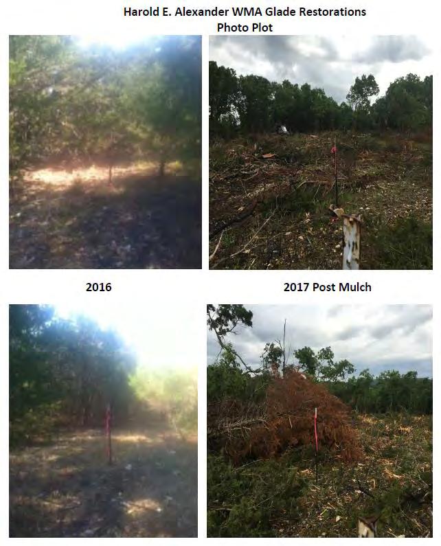
13 Photo Plots 13

,")
.")

14 White Tail East - Recovery White Tail east burn unit lies within the Quail Focal Area which has received WSI chainsaw cedar removal (A), followed immediately by a prescribed burn in March 2018 (B). Photo C and D where taken on May 31st, 2018 approximately 2 months post burn. A. B. C. D

15 15 Fire History Map 15

16 16 Fire History Map 16

17 17 Treatment Map 17

18 Tour Map 18
PROPOSED QUARRY FOOTPRINT PHASE 2 PHASE 3. PHASE 5 West. PHASE 5 East. PHASE 6 West. PHASE 6 East PHASE 7 PHASE 4 PHASE 1
 PHASE 4 \\Cd1220-f02\01609\active\2001 Active Projects\1100-1199\G1188\graphics\GIS\MXD\_Final Draft Sept 2008\MXD\Section_5\62601188_Fig5-0_ProposedQuarryFootprint_01Dec08_NJB.mxd PHASE 7 PHASE 5 West
Treaty Oaks Ranch 323+/- Acres Hood County, Texas $1,776,500
 Bret Polk Mobile: (254) 965-0349 Office: (214) 361-9191 Treaty Oaks Ranch 323+/- Acres Hood County, Texas $1,776,500 LOCATION: The ranch is located in a desirable area 10+/- miles south of Granbury, Texas,
3.0 EXISTING PARK & RECREATION SPACE
 3.0 EXISTING PARK & RECREATION SPACE TOWN PARK & RECREATION SPACE An inventory of current parks and recreation area in the Town of Cedarburg is shown in Table 3. These areas total roughly 381.89 acres.
Blanco Creek Ranch Acres, Uvalde County, Texas
 Blanco Creek Ranch 1208.30 Acres, Uvalde County, Texas James King, Agent Office 432 426.2024 Cell 432 386.2821 James@KingLandWater.com Blanco Creek Ranch 1208.30 acres Uvalde County, Texas James King,
Spatial Distribution and Characteristics of At-Risk Species in the Southeast U.S.
 Nicholas Institute for Environmental Policy Solutions Scoping Document Part 2 Exploratory Analysis of Characteristics and Trends of At-Risk Species in the Southeast U.S. Spatial Distribution and Characteristics
BA Collaborators. Driftless Area Initiative The Prairie Enthusiasts Trout Unlimited TNC TCF Natural Resources Foundation of Wisconsin
 BA Collaborators Driftless Area Initiative The Prairie Enthusiasts Trout Unlimited TNC TCF Natural Resources Foundation of Wisconsin The mission of the of the Blufflands Alliance is to actively conserve
Map 1.1 Wenatchee Watershed Land Ownership
 Map 1.1 Wenatchee Watershed Land Ownership Map 1.1 Wenatchee Watershed Land Ownership The Wenatchee watershed lies in the heart of Washington state in Chelan County. Just larger than the state of Rhode
Stuart River Provincial Park Purpose Statement and Zoning Plan
 Stuart River Provincial Park Purpose Statement and Zoning Plan Stuart River Provincial Park protects three-quarters of the 110 kilometer long Stuart River corridor between Stuart Lake and the Nechako River.
ELKHORN MOUNTAINS PAST, PRESENT, FUTURE PROJECTS
 ELKHORN MOUNTAINS PAST, PRESENT, FUTURE PROJECTS AUGUST 2001 1992 - The Elkhorn MOU among the Helena NF, Deerlodge NF, Bureau of Land Management, and Montana Dept. Fish, Wildlife and Parks was signed establishing
Summary of prescribed fires in Prince Albert National Park 2015
 Summary of prescribed fires in Prince Albert National Park 2015 Prince Albert National Park conducted four controlled fires in spring 2015, plus an additional fire in October. Fuel Management for Hazard
MINIMUM REQUIREMENTS DECISION GUIDE WORKSHEETS
 ARTHUR CARHART NATIONAL WILDERNESS TRAINING CENTER MINIMUM REQUIREMENTS DECISION GUIDE WORKSHEETS Fuel Maintenance Around Red-cockaded Woodpecker Trees on Islands within the Okefenokee Wilderness Area....
Level IV Ecoregions of the Northeast Glacial Lakes Watershed Project Area
 Level IV Ecoregions of the Northeast Glacial Lakes Watershed Project Area Ecoregions are areas having similar ecosystems and environmental resources including geology, physiography, vegetation, climate,
Vermont Cows by Peter Salmon
 Vermont Cows by Peter Salmon SUSTAINABLE FOREST & PROPERTY MANAGEMENT: At current the Dorset Town Forest includes the 30 acre parcel that sits atop Owl s Head peak in Dorset. By acquiring this property
2.0 Physical Characteristics
 _ 2.0 Physical Characteristics 2.1 Existing Land Use for the Project The site is comprised of approximately 114 acres bounded by Highway 101 to the north, the existing town of Los Alamos to the east, State
Daisy Dean Trail 628/619 ATV Trail Construction
 Background and Purpose and Need The Daisy Dean ATV Trail Construction Project is located in the Little Belt Mountains, Musselshell Ranger District, Lewis and Clark National Forest approximately 32 miles
Environmental Geotechnical Planning Construction Testing & Inspection Building Science Duty To Consult
 About Me? 2 Member of the Chippewas of Georgina Island FN Worked in my Community for 17+ years in various capacities Childcare, Council, Housing, Bylaws, Waste Management, Environment, Climate Change 2011
FRIENDFIELD PLANTATION
 FRIENDFIELD PLANTATION A REAL ESTATE INVESTMENT AND SPORTING OPPORTUNITY Friendfield Plantation (est. 1735) For sale $16 million US Friendfield is a 3264 acre property located on the Sampit River near
(/ 12 (/ 18 (/ 18 (/ 12 (/ 51 (/ 14 Æ%106 Æ% 106 Æ% 213 Æ% 104 Æ% 89 Æ% 26 Æ% 73 Æ% 59 Æ% 138 Æ% 92 Æ% 26 Æ% 67 Æ% 11 Æ% 11 Æ% 11. Æÿ H Æÿ Z.
 WAUKESHA Existing Ice Age Trail, subject to change as it evolves toward completion Glacial Drumlin Rail-Trail 94 Ice Age Trail Rock, Walworth and Jefferson Counties Other Trail Unofficial Connecting Route
Segment 4: Hokah to Mound Prairie
 Root River Wildlife Management Area The main unit of this WMA is located just north of the Root River and the city of Hokah. Its 443 acres include mixed hardwoods of oak, basswood, ash, cottonwood, elm
Rouge National Park. Opportunities and Challenges
 Rouge National Park Opportunities and Challenges January 2013 Rouge Park Finch Meander Rouge Beach at Lake Ontario Toronto GLWQA Area of Concern Rouge National Park Nationally Significant First Nation
DOYLE SPRINGS PLANNING UNIT Kern-Tule River Watershed
 Existing Conditions & Uses Overview Consists of a mostly forested parcel with small hydropower developments and part of a private recreation cabin development, along with two small transmission line corridor
SUGARBOWL-GRIZZLY DEN PROVINCIAL PARK AND SUGARBOWL-GRIZZLY DEN PROTECTED AREA Purpose Statement and Zoning Plan
 SUGARBOWL-GRIZZLY DEN PROVINCIAL PARK AND SUGARBOWL-GRIZZLY DEN PROTECTED AREA Purpose Statement and Zoning Plan Located one hour east of Prince George on Highway 16, Sugarbowl-Grizzly Den Provincial Park
Aquatic insect surveys at Mount Magazine State Park and Hobbs State Park Conservation Area with implementation of an educational component
 Aquatic insect surveys at Mount Magazine State Park and Hobbs State Park Conservation Area with implementation of an educational component Arkansas is home to a relatively large number of endemic invertebrates
White Oak Creek. Recreational Use Attainability Analysis Summary of Findings. Texas Institute for Applied Environmental Research Stephenville, Texas
 White Oak Creek Recreational Use Attainability Analysis Summary of Findings Texas Institute for Applied Environmental Research Stephenville, Texas August 8, 2016 Sulphur Springs, Texas August 9, 2016 Mount
USDA Forest Service Deschutes National Forest DECISION MEMO. Round Lake Christian Camp Master Plan for Reconstruction and New Facilities
 USDA Forest Service Deschutes National Forest DECISION MEMO Round Lake Christian Camp Master Plan for Reconstruction and New Facilities Jefferson County, Oregon T. 13 S., R. 8 E., Section 16, W.M. Background:
STREAKED HORNED LARK. Conservation of a threatened species in an industrial landscape. Cat Brown US Fish and Wildlife Service
 STREAKED HORNED LARK Conservation of a threatened species in an industrial landscape Cat Brown US Fish and Wildlife Service HISTORICAL & CURRENT RANGE Streaked Horned Lark Distribution Historical Range:
Ragged Mountain Natural Area. Public Planning Meeting #1 February 29 th, 2016
 Ragged Mountain Natural Area Public Planning Meeting #1 February 29 th, 2016 Planning During dam construction P&R approached by various groups asking if the rules would be changed once the dam was complete
PUBLIC UTILITY DISTRICT NO. I of CHELAN COUNTY P.O. Box 1231, Wenatchee, WA (509) VIA ELECTRONIC FILING
 VIA ELECTRONIC FILING") Wildlife PUBLIC UTILITY DISTRICT NO. I of CHELAN COUNTY P.O. Box 1231, Wenatchee, WA 98807-1231 (509) 663-8121 Toll free 1-888-663-8121 327 N. Wenatchee Ave., Wenatchee, WA 98801 www.chelanpud.org April
Wildlife PUBLIC UTILITY DISTRICT NO. I of CHELAN COUNTY P.O. Box 1231, Wenatchee, WA 98807-1231 (509) 663-8121 Toll free 1-888-663-8121 327 N. Wenatchee Ave., Wenatchee, WA 98801 www.chelanpud.org April
DATE: January 19, WCA Governing Board. Johnathan Perisho, Project Manager. Mark Stanley, Executive Officer
 Item 14 DATE: January 19, 2017 TO: FROM: THROUGH: SUBJECT: WCA Governing Board Johnathan Perisho, Project Manager Mark Stanley, Executive Officer Item 14: Consideration of a resolution to accept an acquisition
Segment 2: La Crescent to Miller s Corner
 goal of the USFWS refuges is to conserve, protect and enhance fish, wildlife and plants and their habitats for the continuing benefit of the American people. Refuge lands are used largely for fishing,
IOWA ORNITHOLOGISTS' UNION - Birding Sites in Cerro Gordo County
 IOWA ORNITHOLOGISTS' UNION - Birding Sites in Cerro Gordo County Printed on 11/17/2018 Blue-wing Marsh GPS Coordinates: 43.0834956379463,-93.4430980682373 Pure natural area primarily used for hunting.
Seager Wheeler Lake. Representative Area. -- Concept Management Plan --
 Seager Wheeler Lake Representative Area -- Concept Management Plan -- Saskatchewan Environment and Resource Management January, 1999 Saskatchewan s Representative Areas Network Program The Government of
Brador hills biodiversity reserve
 Brador hills biodiversity reserve September 2003 1. Plan and description 1.1. Geographic location, boundaries and dimensions The plan of the proposed Brador hills biodiversity reserve and its location
Sibley LUPA. Board Executive Committee Meeting December 7, 2017
 Sibley LUPA Board Executive Committee Meeting December 7, 2017 Project Location & Project Area 1,318-acre Robert Sibley Volcanic Regional Preserve Project Area Purpose Project Purpose & Goals Append the
There are actually six geographic sub-regions, three in both the uplands and the lowlands.
 6 Regions of AR Although Arkansas is most easily divided into two distinct geographical regions, the northwestern uplands and the southeastern lowlands, this description does not accurately portray the
Chapter eight. Parks and Recreation. Introduction. Crystal Lake Park District
 Chapter eight Parks and Recreation Introduction One of the indicators of quality of life in a city is the parks and recreation system. The City of Crystal Lake is fortunate to have an excellent parks and
SECTION 3 GENERAL DESCRIPTION OF THE RIVER BASIN
 SECTION 3 GENERAL DESCRIPTION OF THE RIVER BASIN SECTION 3 GENERAL DESCRIPTION OF THE RIVER BASIN River basin description. A general description of the river basin or subbasin, as appropriate, in which
You can learn more about the trail camera project and help identify animals at WildCam Gorongosa (
 INTRODUCTION Gorongosa National Park is a 1,570-square-mile protected area in Mozambique. After several decades of war devastated Gorongosa s wildlife populations, park scientists and conservation managers
South Texas Plains. Texas, Our Texas
 South Texas Plains This is a region characterized by considerable variety. Climatically, the South Texas Plains region is sub-humid to dry. The in the north part of the South Texas, erosion of the Edwards
Appendix C. Tenderfoot Mountain Trail System. Road and Trail Rehabilitation Plan
 Appendix C Tenderfoot Mountain Trail System Road and Trail Rehabilitation Plan All rehabilitation work would be under the direction of the District Fisheries Biologist, the Forest Hydrologist, and/or the
ECORREGIONAL ASSESSMENT: EASTERN CORDILLERA REAL ORIENTAL PARAMOS AND MONTANE FORESTS
 ECORREGIONAL ASSESSMENT: EASTERN CORDILLERA REAL ORIENTAL PARAMOS AND MONTANE FORESTS The Nature Conservancy, EcoCiencia y Fundación AGUA. 2005. Evaluación Ecorregional de los Páramos y Bosques Montanos
COASTAL CONSERVANCY. Staff Recommendation December 2, 2004 COYOTE HELLYER COUNTY PARK BAY AREA RIDGE TRAIL
 COASTAL CONSERVANCY Staff Recommendation December 2, 2004 COYOTE HELLYER COUNTY PARK BAY AREA RIDGE TRAIL File No. 04-057 Project Manager: Amy Hutzel RECOMMENDED ACTION: Authorization to disburse up to
MILLIGAN HILLS PROVINCIAL PARK
 MILLIGAN HILLS PROVINCIAL PARK PURPOSE STATEMENT AND ZONING PLAN Peace Region 2006 Approved by: Andy Ackerman, Regional Manager Environmental Stewardship Division Peace Region Date: 2006 Nancy Wilkin Assistant
State of Nature 2016
 State Nature 2016 State Nature 2016 Results look up tables This document presents tables the results referred to in the report in an easy to access format. All data presented here feature in the report
Conservation Area Management Statement
 Conservation Area Management Statement Miller Creek Wildlife Area Resolution #: Approval: Issue Date: Date of Last Revision: Table of Contents 1. Purpose....... 1 2. Property Description...... 1 2.1. Legal
David Magney Environmental Consulting
 David Magney Environmental Consulting DELINEATION OF JURISDICTIONAL WATERS AND RIPARIAN HABITATS FOR LYONS CANYON RANCH, NEWHALL, CALIFORNIA Prepared for: UNITED STATES ARMY CORPS OF ENGINEERS and CALIFORNIA
Potomac Gorge. Resource Booklet. A Natural Monument in the Shadow of National Monuments. Bridging the Watershed. Potomac Gorge 75
 Potomac Gorge Potomac Gorge A Natural Monument in the Shadow of National Monuments Resource Booklet Bridging the Watershed An outreach program of the Alice Ferguson Foundation in partnership with the National
Pinellas County Environmental Lands
 Pinellas County Environmental Lands In addition to traditional parks and recreation facilities, Pinellas County owns and manages a system of environmental lands that provides specialized resource-based
OMINEACA PROVINCIAL PARK
 OMINEACA PROVINCIAL PARK AND PROTECTED AREA PURPOSE STATEMENT AND ZONING PLAN March 2003 OMINECA PROVINCIAL PARK AND PROTECTED AREA Purpose Statement and Zoning Plan Omineca Park and Omineca Protected
Watershed Report Blue Mountain Lake-Petit Jean River
 Watershed Report Blue Mountain Lake-Petit Jean River 1111020402 The Center for Advanced Spatial Technologies at the University of Arkansas has developed the Arkansas Automated Reporting and Mapping System
Management Issues in Atlantic N2K sites - a personal view from the Far West!
 National Parks and Wildlife Service of the Department of Arts, Heritage, Regional, Rural and Gaeltacht Affairs Management Issues in Atlantic N2K sites - a personal view from the Far West! 2 nd Atlantic
HIGHWAY 17 WILDLIFE and REGIONAL TRAIL CROSSINGS
 HIGHWAY 17 WILDLIFE and REGIONAL TRAIL CROSSINGS Agenda and Meeting Format 7:00-7:15 Welcome 7:15-8:00 Presentation 8:00-8:30 Open House 8:30 Recap 9:00 Conclusion 2 Meeting Goals: Introduce the project
DIXIE HIGHWAY Region of Peel NAI Area # 1304, 1320, 2449, 2625, 3961
 DIXIE HIGHWAY 407 1 Region of Peel NAI Area # 1304, 1320, 2449, 2625, 3961 Toronto and Region Conservation Authority City of Brampton Size: 36 hectares Watershed: Etobicoke Creek Con 4 E, Lots 13, 14 Ownership:
Whitemouth Falls Provincial Park. Draft Management Plan
 Whitemouth Falls Provincial Park Draft Management Plan Whitemouth Falls Provincial Park Draft Management Plan Table of Contents 1. Introduction... 3 2. Park History... 3 3. Park Attributes... 4 3.1 Natural...
Maya s Creek Crossing Hwy 17 N acres $185,000 Fort Davis, Texas
 Maya s Creek Crossing Hwy 17 N 14.98 acres $185,000 Fort Davis, Texas James King, Agent Office 432-426-2024 Cell 432-386-2821 James@KingLandWater.com King Land & Water LLC P.O. Box 109, 600 State Street,
F.O.K.O.S. Friends of Kingston Open Space A GUIDE TO KINGSTON OPEN SPACE
 F.O.K.O.S. Friends of Kingston Open Space A GUIDE TO KINGSTON OPEN SPACE Friends of Kingston Open Space (FOKOS) was formed when a handful of concerned citizens joined together to learn what could be done
Alternative 3 Prohibit Road Construction, Reconstruction, and Timber Harvest Except for Stewardship Purposes B Within Inventoried Roadless Areas
 Roadless Area Conservation FEIS Summary Table S-1. Comparison of Key Characteristics and Effects by Prohibition Alternative. The effects summarized in this table A would occur in inventoried roadless areas
GREENWOOD VEGETATION MANAGEMENT
 APPENDIX G GREENWOOD VEGETATION MANAGEMENT PROJECT RECREATION RESOURCE REPORT Prepared by: Laurie A. Smith Supervisory Forester Stearns Ranger District Daniel Boone National Forest August 4, 2016 The
NARRABEEN LAGOON SUMMIT am Wednesday, 13 April 2005 Warringah Council Chambers, 725 Pittwater Road, Dee Why.
 NARRABEEN LAGOON SUMMIT 9.15 9.30am Wednesday, 13 April 2005 Warringah Council Chambers, 725 Pittwater Road, Dee Why. NSW Minister for the Environment, the Hon. Bob Debus I am very pleased to be here to
Item 4. Agency Correspondence. U.S. Army Corps of Engineers Jurisdictional Determination. Ohio Department of Natural Resources
 Item 4 Agency Correspondence U.S. Army Corps of Engineers Jurisdictional Determination Ohio Department of Natural Resources U.S. Fish and Wildlife Service Office of Real Estate Paul R.
EXECUTIVE SUMMARY PROGRAM DEVELOPMENT REPORT PURPOSE EXISTING SETTING EXPANDING PARKLAND
 EXECUTIVE SUMMARY PROGRAM DEVELOPMENT REPORT PURPOSE As the culmination of the first phase of the master planning process, this Program Development Report creates the framework to develop the Calero County
Description of the Proposed Action for the Big Creek / Yellow Pine Travel Plan (Snow-free Season) and Big Creek Ford Project
 and Big Creek Ford Project") Description of the Proposed Action for the Big Creek / Yellow Pine Travel Plan (Snow-free Season) and Big Creek Ford Project Payette National Forest Krassel Ranger District Valley and Idaho Counties, Idaho
Description of the Proposed Action for the Big Creek / Yellow Pine Travel Plan (Snow-free Season) and Big Creek Ford Project Payette National Forest Krassel Ranger District Valley and Idaho Counties, Idaho
112th CONGRESS. 1st Session H. R. 113 IN THE HOUSE OF REPRESENTATIVES
 HR 113 IH 112th CONGRESS 1st Session H. R. 113 To provide for additions to the Cucamonga and Sheep Mountain Wilderness Areas in the Angeles and San Bernardino National Forests and the protection of existing
Watchorn Provincial Park. Management Plan
 Watchorn Provincial Park Management Plan 2 Watchorn Provincial Park Table of Contents 1. Introduction... 3 2. Park History... 3 3. Park Attributes... 3 3.1 Natural... 4 3.2 Recreational... 4 3.3 Additional
FIELD UNIT(S): Methow Valley, Entiat, and Tonasket Ranger Districts
: Methow Valley, Entiat, and Tonasket Ranger Districts") Interagency Special Status Species Program Odonate Survey of Bogs, Fens, and Shallow Ponds Okanogan-Wenatchee National Forest John Rohrer December 2014 SPECIES LIST AND RANKS: ISSSP Global WA State Rank
Interagency Special Status Species Program Odonate Survey of Bogs, Fens, and Shallow Ponds Okanogan-Wenatchee National Forest John Rohrer December 2014 SPECIES LIST AND RANKS: ISSSP Global WA State Rank
Decision Memo for Desolation Trail: Mill D to Desolation Lake Trail Relocation
 for Salt Lake County, Utah Uinta-Wasatch-Cache National Forest Salt Lake Ranger District 1. Background The present location of the Desolation Trail (#1159) between Mill D and Desolation Lake follows old
Header i
 Header i 048285014.10 Header Sub Title Body Text here. Body text here. Body text here. Section 1... 1 Executive Summary... 1 Opportunities and Constraints... 3 Overall Opportunities and Constraints Map
Merida Ranch 270+/- Acres Hopkins County, Texas $1,076, ($3,995/acre)
") 270+/- Acres Hopkins County, Texas $1,076,704.43 ($3,995/acre) (214) 361-9191 HRCranch.com Hopkins County, Texas 270+/- Acres LOCATION: is located near Sulphur Bluff, Texas, in northeastern Hopkins County.
270+/- Acres Hopkins County, Texas $1,076,704.43 ($3,995/acre) (214) 361-9191 HRCranch.com Hopkins County, Texas 270+/- Acres LOCATION: is located near Sulphur Bluff, Texas, in northeastern Hopkins County.
IOWA ORNITHOLOGISTS' UNION - Birding Sites in Dallas County
 IOWA ORNITHOLOGISTS' UNION - Birding Sites in Dallas County Printed on 7/19/2018 Beaver Bottoms Wetland (restricted) (Important Bird Area) GPS Coordinates:, Ownership: Private (see directions for access)
MINIMUM REQUIREMENTS DECISION GUIDE WORKSHEETS
 ARTHUR CARHART NATIONAL WILDERNESS TRAINING CENTER MINIMUM REQUIREMENTS DECISION GUIDE WORKSHEETS Prescribed burning of islands within Okefenokee Wilderness Area.... except as necessary to meet minimum
Trends in Biodiversity Indicators
 Trends in Biodiversity Indicators Significant Technical Help: Keith Olsen Etsuko Nonaka Rob Pabst Rebecca Kennedy Jonathan Brooks Mike McGrath Matt Gregory Northern Spotted Owl 1996 Northern Spotted Owl
Allegheny Mountain Cluster
 Allegheny Mountain Cluster Laurel Fork Paddy Lick West Back Creek Mountain The Allegheny Mountain Cluster lies on the backbone of Virginia. Its components are located in the James River and Warm Springs
Cheshire Ecology Ltd.
 Cheshire Ecology Ltd. What is an NVC Survey? 22 March 2014 1 Introduction A National Vegetation Classification (NVC) survey is a detailed botanical survey of a site. They are normally required for large
4988 +/- ACRES JEFFERSON AND LEON COUNTY, FLORIDA
 4988 +/- ACRES JEFFERSON AND LEON COUNTY, FLORIDA Located in the famed Red Hills of north Florida, El Destino Plantation consists of 4988+/- acres and represents an incredible opportunity to own one of
Designated Sites. Headlines
 Designated Sites Headlines Over 36% of the Sheffield district is covered by sites with European, national or local designation. These offer valuable habitats to wildlife, with some level of protection,
B10. Agate Beach State Recreation Site
 B10. Agate Beach State Recreation Site Location Within the City of Newport, just south of the Yaquina Head Outstanding Natural Area. The park is located along the west side of Highway 101 at the mouth
Town of Oakfield Agricultural and Farmland Protection Plan
 SECTION III COMMUNITY OVERVIEW A. Regional Setting / Location The Town of Oakfield is located in the northwestern portion of Genesee County. Located west of New York's Finger Lakes, the Town is uniquely
North Carolina Appalachian Trail License Plate Grant Program Past Grantees and Projects
 North Carolina Appalachian Trail License Plate Grant Program Past Grantees and Projects Since 2005, NC A.T. specialty tags have generated more than $1,392,000 for ATC. Of that amount, the volunteer members
12. Summary and Comparison of Impacts among Routes
 12. Summary and Comparison of Impacts among Routes PSC REF#:155569 CHAPTER 12 This chapter provides a summary and comparison of various potential natural resource and social impacts for the three utility-proposed
Our Mission. Discover the many states of California. Chino Hills State Park 1879 Jackson Street Riverside, Ca (951)
") Chino Hills State Park Our Mission The mission of the California Department of Parks and Recreation is to provide for the health, inspiration and education of the people of California by helping to preserve
Chino Hills State Park Our Mission The mission of the California Department of Parks and Recreation is to provide for the health, inspiration and education of the people of California by helping to preserve
SAN MIGUEL CREEK RANCH. q Trinidad, Las Animas County, Colorado q
 SAN MIGUEL CREEK RANCH q Trinidad, Las Animas County, Colorado q 2 s San Miguel Creek Ranch is a scenic well-balanced cattle and trophy hunting ranch that showcases the very best of Southern Colorado.
at: Accessed May 4, 2011.
 3.11 SAFETY 3.11.1 Background and Methodology As with other forms of transportation, there is risk associated with aviation activities. This section focuses on risk to those on the ground near airports.
Acres Monterey County, California OPEN GROUND IN SALINAS VALLEY VEGETABLE AND STRAWBERRY PROPERTY
 324 +- Acres Monterey County, California OPEN GROUND IN SALINAS VALLEY VEGETABLE AND STRAWBERRY PROPERTY EXCLUSIVELY PRESENTED BY: Morris Garcia License 00834407 (559) 994-7453 Cell Sarah Donaldson License
Preferred Recreation Recommendations Stemilt-Squilchuck Recreation Plan March 2018
 Preferred Recreation Recommendations Stemilt-Squilchuck Recreation Plan March 2018 Below are the recommended recreation ideas and strategies that package together the various recreation concepts compiled
CRAZY HORSE TRAIL GUIDE
 CRAZY HORSE TRAIL GUIDE Abridged Version: July 2016 This is a short form of our interpretive trail guide for the Crazy Horse Trail. The full version of the guide has a more detailed description of the
F RIENDS OF THE SONORAN DESERT Open Space Bond Newsletter
 F RIENDS OF THE SONORAN DESERT Open Space Bond Newsletter Volume 1, Issue 2 Sponsoring Organizations Arizona Open Land Trust Arizona-Sonora Desert Museum Coalition for Sonoran Desert Protection Sonoran
Public Information Exchange
 Public Information Exchange Belton/Stillhouse Hollow Lakes Ronnie Bruggman US Army Corps of Engineers U. S. Army Corps of Engineers Missions Belton/Stillhouse Flood Risk Management Natural Resources Water
Brooker Creek Preserve Management Plan 2008 Update
 Brooker Creek Preserve Management Plan 2008 Update Plan approved by the Board of County Commissioners Pinellas County, Florida 19 August 2008 Pinellas County Department of Environmental Management Environmental
Frizzell Creek Ranch Summerville, OR $1,400, ± Acres
 Frizzell Creek Ranch Summerville, OR $1,400,000 165± Acres 1 Introduction The Frizzell Creek Ranch is a beautiful 165± acre ranch located in northeast Oregon at the base of the Wallowa Whitman National
FINGER-TATUK PROVINCIAL PARK
 FINGER-TATUK PROVINCIAL PARK PURPOSE STATEMENT AND ZONING PLAN March 2003 FINGER-TATUK PROVINCIAL PARK Purpose Statement and Zoning Plan Finger-Tatuk Provincial Park is 17,151 ha in size. It includes the
SF1363 / HF 1061: Legacy Funding; Conference Agreement
 - Conference 1 Art 1 - Outdoor Heritage Fund 2 3 Prairies 4 WMA, SNA, & Prairie Bank Easement Acq. Phase III 5 Accelerated Prairie Restoration - Phase III 6 MN Buffers for Wildlife & Water 7 Northern Tallgrass
ROAD AND TRAIL PROJECT APPROVAL
 ROAD AND TRAIL PROJECT APPROVAL www.marincountyparks.org Marin County Parks, 3501 Civic Center Dr, Suite 260, San Rafael, CA 94903 DATE: July 12, 2017 PRESERVE: Gary Giacomini Open Space Preserve PROJECT:
Green Legacy. Securing our. Greenlands Strategy
 Greenlands Strategy Securing our Green Legacy Together we can create an interconnected network of Greenlands for the health and well-being of the environment and future generations Caring for the Credit
AMENDMENT NO. 03 TO THE OFFICIAL PLAN FOR THE TOWNSHIP OF ADJALA-TOSORONTIO OAK RIDGES MORAINE CONSERVATION PLAN
 AMENDMENT NO. 03 TO THE OFFICIAL PLAN FOR THE TOWNSHIP OF ADJALA-TOSORONTIO OAK RIDGES MORAINE CONSERVATION PLAN Adopted by Council July 19 th, 2004 Approved with modifications by the Province of Ontario
EAST DON TRAIL ENVIRONMENTAL ASSESSMENT. Community Liaison Committee Meeting #3 July 15, :30 to 8:30 pm Flemingdon Park Library
 EAST DON TRAIL ENVIRONMENTAL ASSESSMENT Community Liaison Committee Meeting #3 July 15, 2013 6:30 to 8:30 pm Flemingdon Park Library Agenda 1. Welcome 2. Housekeeping and Updates a) Housekeeping b) CLC
STORNETTA BROTHERS COASTAL RANCH
 STORNETTA BROTHERS COASTAL RANCH Location: Surrounding Point Arena Lighthouse and immediately south of Manchester State Park Mendocino Co., CA Acres: 1,860 Resources: Over two miles of Pacific Ocean coastline
Department of Environment, Climate Change & Water NSW. Stakeholder feedback
 Department of Environment, Climate Change & Water NSW Stakeholder feedback 1 Stakeholders group Blue Gum High Forest Group Guardians of Lane Cove NP Sydney Metropolitan Wildlife Service Ku-ring-gai Historical
Rogue River Access and Management Plan Draft Alternatives
 Rogue River Access and Management Plan Draft Alternatives The Rogue River Access and Management Plan was initiated in December, 2011 and is being led by Jackson County Parks (JCP) and Oregon Department
The new Avian Knowledge Network
 The new Avian Knowledge Network Leo Salas Point Blue Conservation Science Katie Koch U.S. Fish & Wildlife Service Chris Eberly Department of Defense Partners in Flight Outline Brief history of the AKN
Parks & Recreation Areas Program
 PARKS & RECREATION Parks & Recreation Areas Program As part of its mission to conserve and protect natural resources, the Upper Big Blue Natural Resources District (NRD) has been involved in several large-scale