An Initial Archaeological Assessment of John James Park, City of San Antonio, Texas
|
|
|
- Solomon Edwin Sparks
- 5 years ago
- Views:
Transcription


1 Index of Texas Archaeology: Open Access Gray Literature from the Lone Star State Volume 1977 Article An Initial Archaeological Assessment of John James Park, City of San Antonio, Texas Elizabeth Cantu Frkuska Augustine J. Frkuska Fred Valdez, Jr. Thomas R. Hester Follow this and additional works at: Part of the American Material Culture Commons, Archaeological Anthropology Commons, Cultural Resource Management and Policy Analysis Commons, Historic Preservation and Conservation Commons, History Commons, Human Geography Commons, Other Anthropology Commons, Other Arts and Humanities Commons, Other History of Art, Architecture, and Archaeology Commons, Other Social and Behavioral Sciences Commons, and the Technical and Professional Writing Commons Tell us how this article helped you. Repository Citation Frkuska, Elizabeth Cantu; Frkuska, Augustine J.; Valdez, Jr., Fred; and Hester, Thomas R. (1977) "An Initial Archaeological Assessment of John James Park, City of San Antonio, Texas," Index of Texas Archaeology: Open Access Gray Literature from the Lone Star State: Vol. 1977, Article 1. ISSN: Available at: This Article is brought to you for free and open access by SFA ScholarWorks. It has been accepted for inclusion in Index of Texas Archaeology: Open Access Gray Literature from the Lone Star State by an authorized editor of SFA ScholarWorks. For more information, please contact cdsscholarworks@sfasu.edu.
2 An Initial Archaeological Assessment of John James Park, City of San Antonio, Texas Creative Commons License This work is licensed under a Creative Commons Attribution-Noncommercial 4.0 License This article is available in Index of Texas Archaeology: Open Access Gray Literature from the Lone Star State:
3 AN INITIAL ARCHAEOLOGICAL ASSESSMENT OF JOHN JAMES PARK, CITY OF SAN ANTONIO, TEXAS by Elizabeth Cantu Frkuska, Augustine J. Frkuska, Fred Valdez, Jr., and Thomas R. Hester Center for Archaeological Research The University of Texas at San Antonio Archaeological Survey Report No
4 TABLE OF CONTENTS Introduction Soils and Vegetation Archaeological Background The Survey Results of the Survey Summary and Recommendations References Cited Page LIST OF FI GURES Figures 1. The John James Park Area 2. Photographs of John James Park Area 3. Bifaces from 41 BX Unifaces from 41 BX Cores from 41 BX 305 Page
5 ERRATUM Page 9 In the Hester 1975 reference, line 2, please note the following correction: for "South Center Texas ll read "South Central Texas ll
6 INTRODUCTION In January, 1977, the City of San Antonio Department of Parks and Recreation (Ronald L. Darner, Director) and the Center for Archaeological Research, The University of Texas at San Antonio (Thomas R. Hester, Director), entered into a contract for the archaeological assessment of John James Park. The park property (Fig. 1), is located just north of Fort Sam Houston, and the eastern boundary fronts on Salado Creek, a major tributary of the San Antonio River. The field survey was carried out under the general supervision of Dr. Thomas R. Hester and Mr. Jack D. Eaton, with the field crew consisting of Elizabeth Cantu Frkuska, Augustine J. Frkuska and Fred Valdez, Jr. The goal of this initial survey was to provide an assessment of archaeological or historical resources that might be present within the confines of the park, and, if such resources were found, to record and evaluate them. SOILS AND VEGETATION The soils in the survey area consist of the Venus-Frio-Trinity association. The areas closest to the Salado Creek are typically Trinity and Frio soils, which are frequently flooded. The soils on the upland terraces are of the Venus clay loam series (Taylor et at. 1962:45-46). The vegetation is approximately 25 percent grassy fields and 75 percent mixed, with deciduous trees, various types of brush and ground cover. The vegetation list is as follows: prickly pear, yucca (3 species), Christmas cactus, mesquite, oak, hackberry, elm, persimmon and grasses. ARCHAEOLOGICAL BACKGROUND There has been considerable archaeological activity by both professionals and amateurs along the Salado Creek drainage in recent years. Approximately 3.2 kilometers (2 miles) downstream, just south of John James Park, a major prehistoric site (41 BX 194) has been documented on Fort Sam Houston. The site is located on the east bank of the Salado Creek and occupation at that site ranged from early Archaic to Late Prehistoric (T. R. Hester, personal communication). Upstream,.8 kilometers north of the park, 41 BX 294, a prehistoric and historic site complex (the site of the battle of Salado Creek), has been documented and nominated for placement on the National Register of Historic Places, according to J. W. Clark, Jr. (personal communication). Continuing 4.8 to 5.6 kilometers upstream (from the park) along the Salado drainage, a series of sites on high terraces have been located. The Granburg II site (41 BX 271) is located on the west terrace of the Salado and contained a wealth of prehistoric archaeological remains to a depth of more than 3.3 meters (Hester and Kohnitz 1975). On the east terrace about.8 kilometers further upstream is located the Robinson site (Cantu, Lauderdale and Stoner 1976), a portion of the 41 BX 229 complex. This locality has produced evidence of human occupation spanning the past 11,000 years (Hester 1975). THE SURVEY The survey of the city s proposed John James Park concentrated along the drain-
7 Figure 1. The John Jam~ P~k ~ea. Zone 1: dump and fill area; Zone 2: location of 41 BX 305 (site extends SE-NW along the contour intervals, east of the indicated road); Zone 3: natural chert resources.
8 This page has been redacted because it contains restricted information.
9 3 age?f the Salado Creek and the adjacent area to the west. The survey was conf1ned to an area of 61,143 square meters bounded by Rittiman Road on the north, Winans Road on the south, Salado Creek on the east and Fort Sam ~ouston housing/cole Junior and Senior Schools on the west. The park area 1S located on 556,650 me, 3,261 mn on the USGS San Antonio East Quadrangle (7.5 1 series). As noted above, the purpose of this survey was to locate, record and identify any archaeological or historical resources within the proposed park boundaries. Information about the vegetation and soils in the area was also recorded. The survey area was divided into three zones (Fig. 1) on the basis of presence/ absence of archaeological material, the topography. and the nature of the zone (i.e., disturbance). Zone 1 is a dump and fill area. It has been highly disturbed by recent human activity; any archaeological material in this area is mixed and of questionable provenience. Zone 2 is situated along the and contours paralleling Salado Creek. The area closest to the creek is highly eroded and the terrace walls expose lithic materials from soil and gravel horizons. Zone 3 is a relatively flat area. The vegetation cover in this zone made it very difficult to evaluate the area and it is possible that additional archaeological resources may exist in this zone. RESULTS OF THE SURVEY The archaeological survey of John James Park revealed the presence of an extensive prehistoric archaeological site designated as 41 BX 305. The site area is situated within Zone 2 (Fig. 1) and covers approximately 28,000 square meters, although the exact horizontal extent is not known because of heavy ground cover. Vertically the site appears to be quite deep since lithic materials were found eroding out of both a surface soil horizon and much deeper gravels (Fig. 2,b). The southern section of the site area showed evidence of two previous liexcavations,1i probably by relic-collectors. The site surface exhibited quantities of lithic materials including cores, bifaces, unifaces and flakes (Fig. 3-5). Eroded areas reveal lithic remains such as those illustrated in Fig. 3, a-b. These artifacts were associated with a gravel matrix unlike the artifacts found at the top of the terrace in a black soil horizon. Surface lithic materials and scattered burned rock were noted within the site boundaries along the west bank of the Salado Creek from Rittiman Road to Winans Road. Two major lithic concentration areas were documented. Within these concentrations one can note nearly all stages of lithic reduction. Photographs were taken of the artifacts observed (but not collected) in the. field and are on file at the Center for Archaeological Research. Representat1ve examples of these chipped stone artifacts are illustrated in Figures 3-5. In Figure 3 we have illustrated a series of bifaces collected at the site. One is a lanceolate-shaped preform (Fig. 3,a-a l ) found eroding from soil matrix approximately two meters down a slope. A possible point fragment (Fig. 3,d), associated with burned rock debris, was found on the terrace surface. Several
10 Fi gure 2. Pho:togJta.ph6 on :the John Ja.meo Pcvr.k. SUe Mea.. a, terrace above the Salado Creek, looking toward proposed park recreation area; b, wes~ bank of the 'Salado Creek along the east boundary of John James Park.
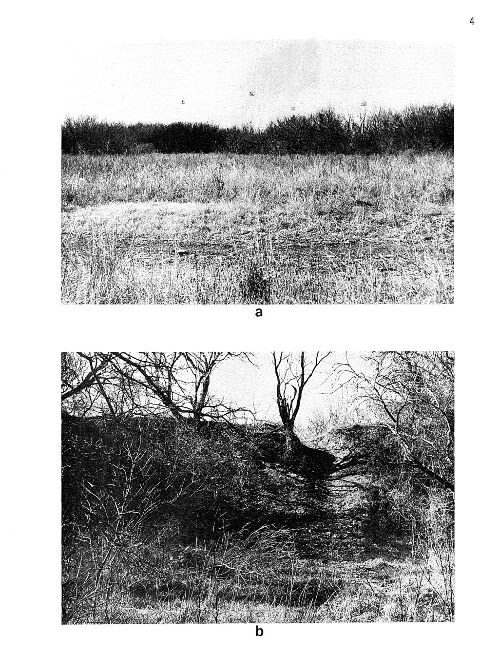
11 4 a b
12 Figure 3. Bi6aQ~ 6~om 41 BX 305. a, ai, lanceolate biface, heavy patina; b~ ovate biface; c, miscellaneous biface (cross section of bit end is shown); d, e, bifacial fragments.
13 5.Q E CJ - ctl
14 Figure 4. un 6ac~ 6~om 41 BX 305. a, b, miscellaneous scrapers; c, broken end scraper; d-f retouched flakes.
15 c
16 7..c o 0 q ''''' L.J.. o. 0 <:;:7. cq -::).~.0 ~ ~ () 0 c:j, o 0 ca
17 8 unifacia1 too~s are shown in Figure 4. The smaller retouched flakes (Fig. ~, e-f),showed slgns of thermal alteration as did a number of smaller flakes not 111ustrated. Two cores from 41 BX 305 are illustrated in Figure 5. Figure 5 is a core which is pot-lidded (from extreme heat) on the cortex; small flakes were detached from the edges, possibly for platform preparation. Larger cores were located and noted throughout the site area. SUMMARY AND RECOMMENDATIONS An archaeological survey of the proposed John James Park revealed the presence of an extensive prehistoric site along the eastern edge of the park area. The site cannot be precisely dated with available evidence, but we suspect that it represents repeated occupations over a period of several thousand years. Salado Creek was apparently the focus of intensive aboriginal activity during most of the prehistoric period, as evidenced by the large and significant sites recorded along the stream to the north and south of the park area. We believe that site 41 BX 305 is of National Register potential; however, further evaluation is necessary before such a recommendation can be made. Through the courtesy of the Department of Parks and Recreation, we were provided with a detailed map indicating the nature of planned development within the new park. During the first phase of park development, a paved bike and hike trail will be routed along the eastern periphery of the archaeological site in the southeastern part of the park. Phase I also calls for clearing, the installation of security lighting)and a picnic area in the northeast corner of the park, also within the boundaries of the site 41 BX 305. Additional picnic units will be scattered along the eastern periphery of the park, again withi'n the site area. Most major surface modifications during Phase I and future park development will, however, be confined to areas to the west (and outside) of the site boundaries (in Zones 1 and 3). It does appear that the modifications mentioned above will cause impact in certain portions of site 41 BX 305. We are unable at this time to evaluate the actual effect that these modifications will have on the site deposits. We are concerned that surface evidence and the upper portions of the deposits in some parts of the site may be adversely affected. The heavy public utilization of this section of the park, involving bike and hike trails, horse trails, and picnic areas, will lead to surface collecting of artifacts, and possibly uncontrolled digging, thereby further damaging the resources at 41 BX 305. We suggest that a second phase of archaeological investigation be car~ied out at 41 BX 305 prior to park development. This second phase would 1nvolve intensive survey and mapping, designed to more precisely delineate the boundaries of the site. Once these are established, park planners may wish to redesign certain areas to shift heavy public use away from the site boundaries. In addition, the excavation of several test pits in the site area would be carried out in this recommended second phase. These excavations would permit a much better evaluation of the archaeological significance and potential of the site. The excavated data would help in determining the eligibility of the site for nomination to the National Register.
18 9 REFERENCES CITED Cantu, E. G., R. Lauderdale and D. Stoner 1976 The Perry Haass Collection, A Preliminary Report. Unpublished manuscript at the Center for Archaeological Research, The University of Texas at San Antonio. Hester, T. R A Chronological Overview of Prehistoric Southern and South Center Texas. Paper delivered at a conference in Monterrey, Mexico, April. To be published in: The. PJte.WZOf1.. y 06 NoftZhe.ClAze.Jtn. Me.uc.a an.d T e.xcia (J. F. Epstein, ed.) Hester, T. R. and H. Kohnitz 1975 The Chronological Placement of IIGuadalupe ll Tools. La. T~~ 2(2); Taylor, F. B. e.t at Soil SUftve.y 06 Be.xafl. Coun.x.y, Te.xClA. u. S. Department of Agriculture, Soil Conservation Service, Series 1962,
AN ARCHAEOLOGICAL ASSESSMENT OF BOERNE CITY PARK, KENDALL COUNTY, TEXAS. Thomas C. Kelly and Thomas R. Hester
 AN ARCHAEOLOGICAL ASSESSMENT OF BOERNE CITY PARK, KENDALL COUNTY, TEXAS Thomas C. Kelly and Thomas R. Hester Center for Archaeological Research The University of Texas at San Antonio Archaeological Survey
AN ARCHAEOLOGICAL SURVEY OF PROPOSED AREAS FOR ALTERNATE ROADWAYS AT OLMOS DAM, SAN ANTONIO, TEXAS
 AN ARCHAEOLOGICAL SURVEY OF PROPOSED AREAS FOR ALTERNATE ROADWAYS AT OLMOS DAM, SAN ANTONIO, TEXAS Dalli! Brown Center for Archaeological Research The Unh'ersity of Texas at San Antonio Archaeological
Settlement Patterns West of Ma ax Na, Belize
 SETTLEMENT PATTERNS WEST OF MA AX NA, BELIZE 1 Settlement Patterns West of Ma ax Na, Belize Minda J. Hernke Faculty Sponsor: Kathryn Reese-Taylor, Department of Sociology/Archaeology ABSTRACT The focus
Background Research and Field Monitoring of Riverwalk Stalls, Downtown San Antonio, Texas
 Index of Texas Archaeology: Open Access Gray Literature from the Lone Star State Volume 1990 Article 9 1990 Background Research and Field Monitoring of Riverwalk Stalls, Downtown San Antonio, Texas I.
Recent Research on Four Sites Spanning 13,000 years from Southwestern New Brunswick, Canada.
 Recent Research on Four Sites Spanning 13,000 years from Southwestern New Brunswick, Canada. Brent D. Suttie¹, Michael A. Nicholas¹, Jason S. Jeandron², Grant R. Aylesworth³, Ashley B. Brzezicki¹, and
ARCHAEOLOGICAL MONITORING OF THE ASHBY STREET DRAINAGE PROJECT, SAN ANTONIO, BEXAR COUNTY, TEXAS
 ARCHAEOLOGICAL MONITORING OF THE ASHBY STREET DRAINAGE PROJECT, SAN ANTONIO, BEXAR COUNTY, TEXAS Anne A. Fox and I. Waynne Cox / Center for Archaeological Research The University of Texas at San Antonio
Archaeological Survey of Areas Proposed for Modification in the Salado Creek Watershed, Bexar County, Texas
 Index of Texas Archaeology: Open Access Gray Literature from the Lone Star State Volume 1974 Article 3 1974 Archaeological Survey of Areas Proposed for Modification in the Salado Creek Watershed, Bexar
Region 1 Piney Woods
 Region 1 Piney Woods Piney Woods 1. This ecoregion is found in East Texas. 2. Climate: average annual rainfall of 36 to 50 inches is fairly uniformly distributed throughout the year, and humidity and temperatures
F. Akai THE TERMINAL PLEISTOCENE MICROBLADE INDUSTRY IN HOKKAIDO (JAPAN): A CASE OF THE SOUTHERN ISHIKARI LOWLAND
: A CASE OF THE SOUTHERN ISHIKARI LOWLAND") F. Akai THE TERMINAL PLEISTOCENE MICROBLADE INDUSTRY IN HOKKAIDO (JAPAN): A CASE OF THE SOUTHERN ISHIKARI LOWLAND This paper reports on the recent discovery of the Terminal Pleistocene microblade industry,
F. Akai THE TERMINAL PLEISTOCENE MICROBLADE INDUSTRY IN HOKKAIDO (JAPAN): A CASE OF THE SOUTHERN ISHIKARI LOWLAND This paper reports on the recent discovery of the Terminal Pleistocene microblade industry,
Understanding user expectations And planning for long term sustainability 1
 Understanding user expectations And planning for long term sustainability 1 What is a natural surface trail? It can be as simple has a mineral soil, mulched or graveled pathway, or as developed as elevated
RESEARCH BULLETIN. Parks Canada. Parcs Canada. Cette publication est disponible en français.
 RESEARCH BULLETIN No. 201 August 1983 Scratching the Surface-Three Years of Archaeological Investigation in Wood Buffalo National Park, Alberta/N.W.T.-Preliminary Summary Report Marc G. Stevenson Archaeology,
Jneneh in the Upper Wadi az-zarqa, in North Central Jordan, First Season 2011.
 Jneneh in the Upper Wadi az-zarqa, in North Central Jordan, First Season 2011. Khaled Douglas Jneneh is located in the north-western periphery of the city of Zarqa (grid ref. 250.88E 165.25N), in North
The Coach House, Mill Lane, Cookham, Berkshire
 The Coach House, Mill Lane, Cookham, Berkshire An Archaeological Watching Brief For Ms Sophia Butler by Stephen Hammond Thames Valley Archaeological Services Ltd Site Code CMC 03/104 October 2003 Summary
Cultural Resource Management Report Deer Valley 4wd Restoration and Blue Lakes Road Maintenance Project R
 Cultural Resource Management Report R2015-05-03-10005 Undertaking Description: The proposes to perform road maintenance and meadow restoration on the Deer Valley 4wd trail and road maintenance on the Blue
White Oak Creek. Recreational Use Attainability Analysis Summary of Findings. Texas Institute for Applied Environmental Research Stephenville, Texas
 White Oak Creek Recreational Use Attainability Analysis Summary of Findings Texas Institute for Applied Environmental Research Stephenville, Texas August 8, 2016 Sulphur Springs, Texas August 9, 2016 Mount
Department of Tourism, Culture and Recreation Provincial Archaeology Office 2012 Archaeology Review February 2013 Volume 11
 Department of Tourism, Culture and Recreation Provincial Archaeology Office 2012 Archaeology Review February 2013 Volume 11 Area 14 of FjCa-14 in Sheshatshiu, portion of feature in southeast corner of
Gorse Stacks, Bus Interchange Excavations Interim Note-01
 Gorse Stacks, Bus Interchange Excavations 2015 Prepared for: Cheshire West & Chester Council Interim Note-01 1 Introduction & Summary Background Since c. 2000 investigations associated with redevelopment
2.0 Physical Characteristics
 _ 2.0 Physical Characteristics 2.1 Existing Land Use for the Project The site is comprised of approximately 114 acres bounded by Highway 101 to the north, the existing town of Los Alamos to the east, State
What Is An Ecoregion?
 Ecoregions of Texas What Is An Ecoregion? Ecoregion a major ecosystem with distinctive geography, characteristic plants and animals, and ecosystems that receives uniform solar radiation and moisture Sometimes
KP Lasnaya 1 River
 KP 370.2 Lasnaya 1 River The Lasnaya 1 River crossing is protected by Reno mattings and a gabion wall on the north bank (Photo 1). The south bank consists of natural river gravel deposits on top of Reno
St. Joe Travel Management EA CULTURAL RESOURCES
 St. Joe Travel Management EA CULTURAL RESOURCES Bruce Gibson May 2015 Regulatory Framework Forest Plan The Idaho Panhandle National Forests (IPNF) Forest Plan requires systematic cultural resource inventory
New Studies in the City of David The Excavations
 The 2013-2014 Excavations Israel Antiquities Authority The intensive archaeological work on the city of David hill during the period covered in this article has continued in previously excavated areas
HYDROLOGY OF GLACIAL LAKES, FORT SISSETON AREA
 PROC. S.D. ACAD. SCI., VOL. 77 (1998) 59 HYDROLOGY OF GLACIAL LAKES, FORT SISSETON AREA Perry H. Rahn Department of Geology & Geological Engineering South Dakota School of Mines and Technology Rapid City,
Holyport Manor Special School, Highfield Lane, Cox Green, Maidenhead, Berkshire
 Holyport Manor Special School, Highfield Lane, Cox Green, Maidenhead, Berkshire An Archaeological recording action For CgMs Consulting by Jennifer Lowe Thames Valley Archaeological Services Ltd Site Code
Triangle Land Conservancy Conservation Area Monitoring Report Carolina North
 Triangle Land Conservancy Conservation Area Monitoring Report Carolina North Property Name: Bolin Creek West Conservation Area Date of visit: March 16, 2017 County: Orange Property Type: Restrictive Covenants
DAMAGE ASSESSMENT OF SAND FENCING GARDEN CITY, NORTH LITCHFIELD AND LITCHFIELD BEACH GEORGETOWN COUNTY, SC
 OF SAND FENCING GARDEN CITY, NORTH LITCHFIELD AND LITCHFIELD BEACH GEORGETOWN COUNTY, SC June 07, 2017 PREPARED FOR: GEORGETOWN COUNTY DEPARTMENT OF PUBLIC SERVICES PREPARED BY: The EARTHWORKS Group 11655
Triangle Land Conservancy Conservation Area Monitoring Report Carolina North
 Triangle Land Conservancy Conservation Area Monitoring Report Carolina North Property Name: Bolin Creek East Conservation Area Date of visit: March 16, 2017 County: Orange Property Type: Restrictive Covenants
Azoria 2004 B700 Final Trench Report RQC
 Azoria 2004 B700 Final Trench Report RQC B700 is a room -2.5m by 4.5m, bounded by wall B711 to north, wall B703 to east, wall B706 to south, and wall B717 to west. B700 is an Archaic storeroom with an
Land off Birdie Way, Rush Green, Hertford, Hertfordshire
 Land off Birdie Way, Rush Green, Hertford, Hertfordshire An Archaeological Evaluation for Bride Hall Development Limited by Sarah Coles Thames Valley Archaeological Services Site Code RGH00/ 01 January
Daisy Dean Trail 628/619 ATV Trail Construction
 Background and Purpose and Need The Daisy Dean ATV Trail Construction Project is located in the Little Belt Mountains, Musselshell Ranger District, Lewis and Clark National Forest approximately 32 miles
Version Isolated & Non-Waters Only 1 of 3
 APPROVED JURISDICTIONAL DETERMINATION FORM U.S. Army Corps of Engineers SECTION I: BACKGROUND INFORMATION A. REPORT COMPLETION DATE FOR APPROVED JURISDICTIONAL DETERMINATION (JD): July 6, 2010. B. DISTRICT
AN ARCHAEOLOGICAL SURVEY FOR ASYLUM CREEK AND NO NAME CREEK CHANNEL RECTIFICATION PROJECT, BEXAR COUNTY, TEXAS
 AN ARCHAEOLOGICAL SURVEY FOR ASYLUM CREEK AND NO NAME CREEK CHANNEL RECTIFICATION PROJECT, BEXAR COUNTY, TEXAS Kevin J. Gross I. Waynne Cox Texas Antiquities Conunittee Pennit No. 1147 Center for Archaeological
Trench 91 revealed that the cobbled court extends further to the north.
 Report on the 2013 Gournia Excavations The 2013 excavations at Gournia were conducted June 17 July 26 under the aegis of the American School of Classical Studies at Athens and the supervision of the KD
Archaeological Evaluation Report
 Holywell House Osney Mead Oxford o a November 2007 Client: Knowles and Son Issue N o : 1 OA Job N o : 3826 Planning Ref N o : 02/01800/FUL NGR: SP 502 055 Client Name: Knowles and Son Client Ref No: Document
ANNUAL REPORT: ANCIENT METHONE ARCHAEOLOGICAL PROJECT 2014 FIELD SCHOOL
 ANNUAL REPORT: ANCIENT METHONE ARCHAEOLOGICAL PROJECT 2014 FIELD SCHOOL Director(s): Co- Director(s): Professor Sarah Morris, Cotsen Institute of Archaeology, UCLA John K. Papadopoulos, Cotsen Institute
In 2014 excavations at Gournia took place in the area of the palace, on the acropolis, and along the northern edge of the town (Fig. 1).
.") Gournia: 2014 Excavation In 2014 excavations at Gournia took place in the area of the palace, on the acropolis, and along the northern edge of the town (Fig. 1). In Room 18 of the palace, Room A, lined
Gournia: 2014 Excavation In 2014 excavations at Gournia took place in the area of the palace, on the acropolis, and along the northern edge of the town (Fig. 1). In Room 18 of the palace, Room A, lined
Blanco Creek Ranch Acres, Uvalde County, Texas
 Blanco Creek Ranch 1208.30 Acres, Uvalde County, Texas James King, Agent Office 432 426.2024 Cell 432 386.2821 James@KingLandWater.com Blanco Creek Ranch 1208.30 acres Uvalde County, Texas James King,
IKLAINA ARCHAEOLOGICAL PROJECT 2012 FIELD REPORT
 IKLAINA ARCHAEOLOGICAL PROJECT 2012 FIELD REPORT Michael B. Cosmopoulos The sixth season of the Iklaina Archaeological Project was conducted for six weeks in June and July 2012. Τhe project is conducted
Bear Creek Habitat Improvement Project
 06/10/10 Bear Creek Habitat Improvement Project El Paso County, Colorado Pike National Forest and Colorado Springs Utilities Owned Land Report prepared by: Eric Billmeyer Executive Director Rocky Mountain
Triangle Land Conservancy Conservation Area Monitoring Report Carolina North
 Triangle Land Conservancy Conservation Area Monitoring Report Carolina North Property Name: Bolin Creek East Conservation Area Date of visit: 4/8/2015 County: Orange Property Type: Restrictive Covenants
Original Report F WIN , F WIN Prepared for Northland Power and Ministry of Tourism and Culture
 STAGE 2 ARCHAEOLOGICAL ASSESSMENT McLEAN S MOUNTAIN WIND FARM Part Lots 12-15, Concession 3 Geographic Township of Howland Part Lot 24, Concession 12 Geographic Township of Bidwell and Goat Island (formerly
Labrador - Island Transmission Link Target Rare Plant Survey Locations
 27-28- Figure: 36 of 55 29-28- Figure: 37 of 55 29- Figure: 38 of 55 #* Figure: 39 of 55 30- - east side Figure: 40 of 55 31- Figure: 41 of 55 31- Figure: 42 of 55 32- - secondary Figure: 43 of 55 32-
EAST DON TRAIL ENVIRONMENTAL ASSESSMENT. Community Liaison Committee Meeting #3 July 15, :30 to 8:30 pm Flemingdon Park Library
 EAST DON TRAIL ENVIRONMENTAL ASSESSMENT Community Liaison Committee Meeting #3 July 15, 2013 6:30 to 8:30 pm Flemingdon Park Library Agenda 1. Welcome 2. Housekeeping and Updates a) Housekeeping b) CLC
The Tel Burna Archaeological Project Report on the First Season of Excavation, 2010
 The Tel Burna Archaeological Project Report on the First Season of Excavation, 2010 By Itzick Shai and Joe Uziel Albright Institute for Archaeological Research Jerusalem, Israel April 2011 The site of
Monitoring Report No. 227
 City of Derry Airport Longfield More townland Eglinton County Derry AE/10/61 Ruth Logue Site Specific Information Site location: City of Derry Airport, Airport Road, Eglinton, BT47 3GY Townland: Longfield
ROBERTS CREEK PROVINCIAL PARK MASTER PLAN. November, 1981
 Ministry of Lands, Parks and Housing Parks and Outdoor Recreation Division Park Operations Branch North Vancouver, B. C. ROBERTS CREEK PROVINCIAL PARK MASTER PLAN November, 1981 Mr. G. Trachuk Director
Excavations at El Palenque, San Martín Tilcajete: A Late Formative Subregional Center in the Oaxaca Valley, México
 FAMSI 2000: Elsa M. Redmond Excavations at El Palenque, San Martín Tilcajete: A Late Formative Subregional Center in the Oaxaca Valley, México Research Year: 1999 Culture: Zapotec Chronology: Late Pre-Classic
Archaeologists for Hire: An In-Class Activity
 Archaeologists for Hire: An In-Class Activity Beyond Grades: Capturing Authentic Learning Conference Welcome to the Marveloso Valley, a fictional valley on the central coast of Peru. Over the decades,
San Juan Resource Area Recreation Impact Inventory/Monitoring
 San Juan Resource Area Recreation Impact Inventory/Monitoring Indian Creek Climbing Area Overview & Summary of Findings 2007 Pam Foti, Professor Aaron Divine, Lecturer Janet Lynn, Program Coordinator Northern
Appendix C. Tenderfoot Mountain Trail System. Road and Trail Rehabilitation Plan
 Appendix C Tenderfoot Mountain Trail System Road and Trail Rehabilitation Plan All rehabilitation work would be under the direction of the District Fisheries Biologist, the Forest Hydrologist, and/or the
2.0 PARK VISION AND ROLES
 2.0 PARK VISION AND ROLES 2.1 Significance in the Protected Area System Marble Range and Edge Hills provincial parks protect 6.8% of the Pavillion Ranges Ecosection, which is located in the Southern Interior
 6-18 8SE80 This site (unnamed) is located in the northeast quarter of Section 20 in Township 19 South, Range 30 East (USGS Sanford, Fla. 1965, PR 1988) (Figure 6.1). The site occurs on Adamsville-Sparr
Triangle Land Conservancy Conservation Area Monitoring Report Carolina North
 Triangle Land Conservancy Conservation Area Monitoring Report Carolina North Property Name: Crow Branch Conservation Area Date of visit: March 16, 2016 County: Orange Property Type: Restrictive Covenants
oi.uchicago.edu TALL-E BAKUN
 TALL-E BAKUN ABBAS ALIZADEH After I returned in September 1991 to Chicago from Cambridge, Massachusetts, I began preparing for publication the results of 1937 season of excavations at Tall-e Bakun, one
M.J. Milne & Associates Ltd.
 M.J. Milne & Associates Ltd. March, 29 Tolko Industries Ltd. 6 Yellowhead Highway RR#, Site, C Kamloops, BC V2C K Attention: Mr. Michael Bragg, R.P.F. Dear Sir: Re: Risk Rating Evaluation Non-status Roads
BRONZE AGE FIELD SYSTEM AT SOUTHAMPTON AIRPORT
 Proc. Hampshire Field Club Archaeol. Soc. 65, 2010, 1-6 (Hampshire Studies 2010) BRONZE AGE FIELD SYSTEM AT SOUTHAMPTON AIRPORT By J SULIKOWSKA With contributions by LORRAINE MEPHAM and CHRIS J STEVENS
ETOBICOKE CREEK NORTH TRAIL PROJECT. May 18, 2017 at Michael Power High School 105 Eringate Drive, Etobicoke ON M9C 3Z7
 ETOBICOKE CREEK NORTH TRAIL PROJECT May 18, 2017 at Michael Power High School 105 Eringate Drive, Etobicoke ON M9C 3Z7 1 Purpose of Open House The purpose of today s open house is to present the design
Hydraulic Report. Trail 5 Snowmobile Trail Over Mulligan Creek. Prepared By: COLEMAN ENGINEERING COMPANY Karisa V. Falls, P.E.
 Prepared for: Prepared by: Marquette County Road Commission Coleman Engineering Company Marquette, Michigan Iron Mountain, MI December 2011 Hydraulic Report Trail 5 Snowmobile Trail Over Mulligan Creek
Remote Sensing into the Study of Ancient Beiting City in North-Western China
 Dingwall, L., S. Exon, V. Gaffney, S. Laflin and M. van Leusen (eds.) 1999. Archaeology in the Age of the Internet. CAA97. Computer Applications and Quantitative Methods in Archaeology. Proceedings of
Appendix A Appendix A (Project Specifications) Auk Auk / Black Diamond (Trail 44) Reroute
 Auk Auk / Black Diamond (Trail 44) Reroute") Appendix A (Project Specifications) Auk Auk / Black Diamond (Trail 44) Reroute I. Proposed Action: This project proposes to reroute approximately 1,800 feet of a 50 inch wide trail, off of private property
Appendix A (Project Specifications) Auk Auk / Black Diamond (Trail 44) Reroute I. Proposed Action: This project proposes to reroute approximately 1,800 feet of a 50 inch wide trail, off of private property
Trail Assessment Report
 Trail Assessment Report Trail Options for the Bear Creek Canyon located in Pikes Peak Ranger District, Pike National Forest and on Colorado Springs Utility Lands Due to the presence of a unique species
Society Member to Supervise the Building of James Monroe s Birthplace House Charles Belfield, a councilor of the War of 1812 Society in the
 Society Member to Supervise the Building of James Monroe s Birthplace House Charles Belfield, a councilor of the War of 1812 Society in the Commonwealth of Virginia has been designated as the supervisor
ROUKEN GLEN: BANDSTAND 2015 DATA STRUCTURE REPORT
 ROUKEN GLEN: BANDSTAND 2015 DATA STRUCTURE REPORT Author (s) Ian Hill Editors Report Date June 2015 Working Partners Funders Phil Richardson East Renfrewshire Council East Renfrewshire Council, Heritage
The Year in Review 2014, Beothuk Institute Inc. We have had several highlights this year. At the AGM in May there were two guest speakers, Dale
 The Year in Review 2014, Beothuk Institute Inc. We have had several highlights this year. At the AGM in May there were two guest speakers, Dale Jarvis set the stage for the story gathering that the Beothuk
ARCHAEOLOGY IN TUCSON
 ARCHAEOLOGY IN TUCSON Vol.1, No.4 Newsletter of the Institute for American Research Summer 1987 TRULY THE ORIGINAL TUCSON! In our last AIT newsletter, we presented some of the background about the San
A Study of Ancient Resharpening
 A Study of Ancient Resharpening By James R. Bennett, Jim Fisher, & Dan Long Published in Identifying Altered Ancient Flint Artifacts: Relics & Reproductions Series Book II by James R. Bennett The goal
Triangle Land Conservancy Conservation Area Monitoring Report Carolina North
 Triangle Land Conservancy Conservation Area Monitoring Report Carolina North Property Name: Crow Branch Conservation Area Date of visit: 4/8/2015 County: Orange Property Type: Restrictive Covenants Local
Appendix F Environmental Data for Alternative Route Evaluation
 Appendix F Environmental Data for Alternative Route Evaluation (This page intentionally left blank) Cooks Point 138-kV Transmission Line Project Appendix F Index to Appendix F Environmental Data by Alternative
IIBANNING: A MINNESOTA STATE PARK DEVELOPMENT PROJECT RECONNAISSANCE SURVEY II E. STREIFF
 This document is made available electronically by the Minnesota Legislative Reference Library as part of an ongoing digital archiving project. http:www.leg.state.mn.uslrllrl.asp BANNNG: A MNNESOTA STATE
A Brief Overview of the Rio Grande Compact 04/26/06
 A Brief Overview of the Rio Grande Compact 04/26/06 The New Mexico Interstate Stream Commission Investigate, Protect, Conserve, and Develop the State s Waters and Stream Systems Negotiate and Administer
Erica Kinias Brown University, Department of the History of Art and Architecture
 Erica Kinias Brown University, Department of the History of Art and Architecture Archaeological Institute of America Jane C. Waldbaum Scholarship Fund Research Outcomes With the generous support from the
David Magney Environmental Consulting
 David Magney Environmental Consulting DELINEATION OF JURISDICTIONAL WATERS AND RIPARIAN HABITATS FOR LYONS CANYON RANCH, NEWHALL, CALIFORNIA Prepared for: UNITED STATES ARMY CORPS OF ENGINEERS and CALIFORNIA
Welcome KROSNO CREEK DIVERSION PROJECT CLASS ENVIRONMENTAL ASSESSMENT
 Welcome KROSNO CREEK DIVERSION PROJECT PUBLIC INFORMATION CENTRE # 1 Tonight s Presentation Study Overview Background Existing Conditions Alternative Solutions Preliminary Preferred Solution Next Steps
Summary of prescribed fires in Prince Albert National Park 2015
 Summary of prescribed fires in Prince Albert National Park 2015 Prince Albert National Park conducted four controlled fires in spring 2015, plus an additional fire in October. Fuel Management for Hazard
Preferred Recreation Recommendations Stemilt-Squilchuck Recreation Plan March 2018
 Preferred Recreation Recommendations Stemilt-Squilchuck Recreation Plan March 2018 Below are the recommended recreation ideas and strategies that package together the various recreation concepts compiled
There are actually six geographic sub-regions, three in both the uplands and the lowlands.
 6 Regions of AR Although Arkansas is most easily divided into two distinct geographical regions, the northwestern uplands and the southeastern lowlands, this description does not accurately portray the
AQCHAEOLOCICAL MONITOQINC or TilE 0AN J00E ACEQJlIA (41 J)X 267), WA0TEWATEQ FACILITIE0 IMPQOVEMENT0 PQOCQAM, < >AN ANTONIO, TEXA0
X 267), WA0TEWATEQ FACILITIE0 IMPQOVEMENT0 PQOCQAM, < >AN ANTONIO, TEXA0") AQCHAEOLOCICAL MONITOQINC or TilE 0AN J00E ACEQJlIA (41 J)X 267), WA0TEWATEQ FACILITIE0 IMPQOVEMENT0 PQOCQAM, < >AN ANTONIO, TEXA0 I. Waynne Cox.! / Center for Archaeological Research The University of
AQCHAEOLOCICAL MONITOQINC or TilE 0AN J00E ACEQJlIA (41 J)X 267), WA0TEWATEQ FACILITIE0 IMPQOVEMENT0 PQOCQAM, < >AN ANTONIO, TEXA0 I. Waynne Cox.! / Center for Archaeological Research The University of
Photopoint Monitoring in the Adirondack Alpine Zone
 Photopoint Monitoring in the Adirondack Alpine Zone Julia Goren (PI) and Seth Jones Adirondack High Peaks Summit Steward Program Adirondack Mountain Club summit@adk.org PO Box 867, Lake Placid, NY 12946
Appendix F Cultural Resource Consultation
 Appendix F Cultural Resource Consultation FAA Consultation Letter to the California State Historic Preservation Officer Response Letter from the California State Historic Preservation Officer STATE
4. Bronze Age Ballybrowney, County Cork Eamonn Cotter
 4. Bronze Age Ballybrowney, County Cork Eamonn Cotter Illus. 1 Location map of the excavated features at Ballybrowney Lower (Archaeological Consultancy Services Ltd, based on the Ordnance Survey Ireland
KNIGHTS LANDING RIVER RANCH WOODLAND, CA - YOLO COUNTY
 PROPERTY HIGHLIGHTS ±77.2 Gross Acres Contains Excellent Sandy and Silty Clay Loam Soils Established Surface Water Rights in Sacramento River Developed River Diversion and Distribution System Three Phase
Archaeological Investigations Project Yorkshire & Humberside Region NORTH YORKSHIRE 2/1113 (C.36.J002) SD
 SD") NORTH YORKSHIRE Craven 2/1113 (C.36.J002) SD 93607800 CRAY BECK, BUCKDEN, UPPER WHARFEDALE Cray Beck, The Archaeological Investigation of a Stone Feature Archetype Wensleydale : ArcheType Archaeological
NORTH YORKSHIRE Craven 2/1113 (C.36.J002) SD 93607800 CRAY BECK, BUCKDEN, UPPER WHARFEDALE Cray Beck, The Archaeological Investigation of a Stone Feature Archetype Wensleydale : ArcheType Archaeological
Figure 1 Understanding Map Contours
 Figure 1 Understanding Map Contours The light brown lines overprinted on topographic maps are called contour lines. They indicate the elevation above sea level of land features and thus permit you to view
ARCHAEOLOGICAL SURVEY PROPOSED SYCOLIN ROAD OVERPASS OF ROUTE 7/15 BYPASS LEESBURG, LOUDOUN COUNTY, VIRGINIA
 ARCHAEOLOGICAL SURVEY PROPOSED SYCOLIN ROAD OVERPASS OF ROUTE 7/15 BYPASS LEESBURG, LOUDOUN COUNTY, VIRGINIA VDOT PROJECT 6007-053-S96, B666, C501, D656, P101, R201 (UPC 99256) VDHR PROJECT: 2012-0251
Excavations in a Medieval Market Town: Mountsorrel, Leicestershire,
 Excavations in a Medieval Market Town: Mountsorrel, Leicestershire, by John Lucas Mountsorrel is situated 12 kms north of Leicester and forms a linear settlement straddling the A6, Leicester to Derby road.
DRAFT. Dorabelle Campground Rehabilitation
 DRAFT Dorabelle Campground Rehabilitation September 2012 1.1 REGIONAL SETTING AND PROJECT LOCATION The Dorabelle Campground is located on the western shore of Shaver Lake in Fresno County, California (Section
Table 1: Santiago Peak Communication Site. Latitude 1 Longitude 1 Elev 2 Address T/R/S 3 APN 4 USGS Quadrangle
 County of Riverside Public Safety Enterprise Communication Project Appendix A: Candidate Site Descriptions Overview The site is located in the Cleveland National Forest (CNF) at an existing communication
Redesigning The Waterfront
 San Francisco Maritime National Park Service U.S. Department of the Interior National Historical Park California Redesigning The Waterfront A Self-Guided Walking Tour Then & Black Point Cove, ca. 1910.
Cholesbury New House, Parrots Lane, Cholesbury, Buckinghamshire
 Cholesbury New House, Parrots Lane, Cholesbury, Buckinghamshire An Archaeological Watching Brief For Mr Martin Wood by Sean Wallis Thames Valley Archaeological Services Ltd Site Code PLC 06/135 March 2007
Understanding the caring capacity of the visitor experience Provide facilities to support a high level user experience Address visual quality through
 Understanding the caring capacity of the visitor experience Provide facilities to support a high level user experience Address visual quality through recreation ecological restoration opportunities Collaboration
Specification for Grip blocking using Peat Dams
 Technical Guidance Note 1 Specification for Grip blocking using Peat Dams 1. Introduction Moorland drains (grips) have been dug across much of the Yorkshire upland peatlands. Many of these grips have become
The Holes Creek Bridge Replacement By Bradley McClelland
 The Holes Creek Bridge Replacement By Bradley McClelland Each time there is a heavy rainstorm, the folks along Sheffield Road in the Dayton, Ohio suburb of West Carrollton have cause to be concerned. Holes
Northeast Stoney Trail In Calgary, Alberta
 aci Acoustical Consultants Inc. 5031 210 Street Edmonton, Alberta, Canada T6M 0A8 Phone: (780) 414-6373, Fax: (780) 414-6376 www.aciacoustical.com Environmental Noise Computer Modelling For Northeast Stoney
ARCHAEOLOGICAL INVESTIGATIONS IN GUADALUPE, NORTHEAST HONDURAS
 ARCHAEOLOGICAL INVESTIGATIONS IN GUADALUPE, NORTHEAST HONDURAS Markus Reindel, Franziska Fecher and Peter Fux Archaeological investigations in Honduras have focused on the western, Mesoamerican part of
Wessex Archaeology. Little Stubbings, West Amesbury, Salisbury, Wiltshire. Archaeological Watching Brief. Ref:
 Wessex Archaeology Little Stubbings, West Amesbury, Salisbury, Wiltshire Ref: 63280.02 March 2007 LITTLE STUBBINGS, WEST AMESBURY, NR SALISBURY, WILTSHIRE ARCHAEOLOGICAL WATCHING BRIEF Prepared for: P
Big Cook s Pond Cottage Management Plan. Environmental Assessment Registration
 GOVERNMENT OF NEWFOUNDLAND AND LABRADOR Department of Environment and Conservation Lands Branch, Land Management Division Big Cook s Pond Cottage Management Plan Environmental Assessment Registration 1.
Provincial Archaeology Office Annual Review
 2017 Provincial Archaeology Office Annual Review Provincial Archaeology Office Department of Tourism, Culture, Industry and Innovation Government of Newfoundland and Labrador March 2018 Volume 16 A brief
Finn Creek Park. Management Direction Statement Amendment
 Finn Creek Park Management Direction Statement Amendment November 2013 Management Direction Statement Amendment Approved by: Jeff Leahy Regional Director, Thompson Cariboo BC Parks November 12, 2013 Date
Introduction to Topographic Maps
 Introduction to Topographic Maps DIRECTIONS: Read all of the following content. READ EVERYTHING!! At the end of the packet, you will find two topographic maps. Your task is to indentify each of the elevations
Archaeological Investigations Project South East Region SOUTHAMPTON 2/842 (C.80.C004) SU
 SU") SOUTHAMPTON City of Southampton 2/842 (C.80.C004) SU 4382 1336 125 BITTERNE ROAD WEST, SOUTHAMPTON Report on the Archaeological Evaluation Excavation at 125 Bitterne Road West, Southampton Russel, A. D
SOUTHAMPTON City of Southampton 2/842 (C.80.C004) SU 4382 1336 125 BITTERNE ROAD WEST, SOUTHAMPTON Report on the Archaeological Evaluation Excavation at 125 Bitterne Road West, Southampton Russel, A. D