Wilderness Assessment Report. Addition to Cape Torrens Wilderness Protection Area 2017
|
|
|
- Shon Day
- 5 years ago
- Views:
Transcription

1 Wilderness Assessment Report Addition to Cape Torrens Wilderness Protection Area 2017
2 TABLE OF CONTENTS EXECUTIVE SUMMARY INTRODUCTION WILDERNESS PROTECTION IN SOUTH AUSTRALIA Concept of Wilderness Benefits of Protecting Wilderness Wilderness Management DESCRIPTION OF THE STUDY AREA Biological and Geological Values Cultural Heritage Current Management Framework Resource Utilisation WILDERNESS ASSESSMENT Wilderness Protection Act 1992 Criteria RECOMMENDATIONS Land that Meets the Wilderness Protection Act 1992 Criteria Benefits of Protection Under the Wilderness Protection Act BIBLIOGRAPHY APPENDIX A: Wilderness Assessment Process APPENDIX B: Code of Management for Wilderness Protection Areas and Zones in South Australia APPENDIX C: Minimum Impact Code for Wilderness Use in South Australia APPENDIX D: Species Lists Within Assessment Area APPENDIX E: Conservation Status Codes APPENDIX F: Summary of Management Strategies for Cape Torrens Wilderness Protection Area ACKNOWLEDGEMENTS A field inspection of the assessment area was conducted on behalf of the Parks and Wilderness Council by DEWNR staff members Rob Ellis, Caroline Paterson, Elspeth Young and Nick Neagle in November This report was prepared by Nick Neagle of the Protected Areas Unit, DEWNR. Front Cover: De Mole River running through dense Sugar Gum (Eucalyptus cladocalyx ssp. crassa) and Drooping Sheoak (Allocasuarina verticillata) Woodland (N. Neagle, DEWNR). Addition to Cape Torrens Wilderness Protection Area Assessment Report 2017 i
3 EXECUTIVE SUMMARY The Wilderness Protection Act 1992 enables the protection of wilderness and provides a role for the Parks and Wilderness Council in the creation of wilderness protection areas. The roles of the Council include assessing all land in the State to identify areas that meet the wilderness criteria to a sufficient extent to justify protection under the Act, reporting to the Minister on these assessments, and making recommendations to the Minister as to what land should be constituted as wilderness protection area. This includes the assessment of specific land parcels when proposed for protection as a Wilderness Protection Area (WPA). The purpose of this report is to review the wilderness quality of the proposed addition to Cape Torrens Wilderness Protection Area (Allotment 1 in DP 23502). Allotment 1 in DP is an area of hectares adjacent to the south-eastern boundary of Cape Torrens WPA. It was purchased by DEWNR in 2014 because of its high biodiversity values and proximity to Cape Torrens WPA with the intention that it be added to that WPA. This is the first instance of DEWNR specifically purchasing freehold land to create or add to a wilderness area. The assessment area is of very high biodiversity value as it contains intact high rainfall woodland communities in good condition; a significant proportion of the De Mole River and its catchment; nationally threatened flora and fauna species; State threatened ecological communities; and a high plant species diversity. It has high wilderness quality as a result of very limited post-settlement land use. The area has been privately managed for conservation for over 20 years. There is no evidence of grazing and it appears largely undisturbed other than a single 4WD track and a small clearing containing a transportable house. Approximately 70% of the parcel s boundary adjoins existing protected areas (Cape Torrens Wilderness Protection Area and a Heritage Agreement), and a further 20% adjoins unprotected though intact native vegetation. The area has no public vehicle access and is distant to permanent settlements. The vegetation is in good condition and largely contiguous with other minimally disturbed areas. It has a very low percentage (6%) of exotic plant species, none of which are listed as pest plants under the Natural Resource Management Act Exotic fauna numbers are also low, amounting to 6% of all fauna species, and appear to be in low abundance. Recommendations The Parks and Wilderness Council: 1. Finds that, as this land is largely unaffected by modern technology and not seriously affected by exotic plants or animals, it meets the wilderness criteria of the Wilderness Protection Act 1992 (the Act) to a sufficient extent to justify protection under the Act. The extent of land which could recommended to be protected under the Act is shown in Figure Notes that the area will, in particular,: a) afford protection to virtually all of a wild river (De Mole River) and its catchment, a rarity in South Australia; and b) protect biologically significant assets, including virtually all of the known range of the De Mole River Correa (Correa calycina var. halmaturorum); and Sugar Gum and Drooping Sheoak Woodlands that provide feeding and nesting habitat for the Glossy Black Cockatoo (Calyptorhynchus lathami halmaturinus) Addition to Cape Torrens Wilderness Protection Area Assessment Report
4 3. Recommends to the Minister that the boundaries of Cape Torrens Wilderness Protection Area be altered to include the assessment area. Figure 1: Land recommended for protection under the Wilderness Protection Act 1992 Addition to Cape Torrens Wilderness Protection Area Assessment Report
 Woodland over Bracken (Pteridium esculentum ssp.")
.")
5 Sugar Gum (Eucalyptus cladocalyx ssp. crassa) Woodland over Bracken (Pteridium esculentum ssp. esculentum) on the floodplain of the De Mole River (N. Neagle, DEWNR). Addition to Cape Torrens Wilderness Protection Area Assessment Report
6 1. INTRODUCTION The Wilderness Protection Act 1992 requires the Parks and Wilderness Council to assess all land in the State and identify those parts of the State that meet the wilderness criteria to a sufficient extent to justify protection under the Act or that warrant restoration to a condition that justifies such protection. The Council is required to report to the Minister for Sustainability, Environment and Conservation (the Minister) making recommendations regarding: the land in the State that should be constituted as wilderness protection areas and wilderness protection zones; and matters which require special management in relation to wilderness protection areas or zones generally, or in relation to a particular wilderness protection area or zone. In addition, the Council is obliged to assess land at the request of members of the public. In 1993 the Wilderness Advisory Committee produced a report on areas of Kangaroo Island recommended for protection under the Wilderness Protection Act 1992, which included Cape Torrens Conservation Park. This report, which was released for public consultation and its recommendations approved by the then Minister of Environment and Land Management, recommended that the entire Cape Torrens Conservation Park be constituted as a wilderness protection area. However, when Cape Torrens Wilderness Protection Area (874 hectares) was proclaimed on 15 October 1993 the land to low water mark parcel (Allotment 100 in DP 31584) was omitted. The Wilderness Advisory Committee, in the 2002 report to the Minister Report on the Management of Three Wilderness Protection Areas on Kangaroo Island, recommended that this coastal land should also be constituted as a wilderness protection area. Consequently, on 5 October 2006, it was proclaimed as an addition to Cape Torrens Wilderness Protection Area. In 2013 an opportunity arose for the Department of Environment, Water and Natural Resources (DEWNR) to purchase an adjacent land parcel on the south-eastern boundary of the existing park. With substantial assistance from the Foundation for National Parks and Wildlife, New South Wales, Allotment 1 in DP (167.8 hectares) was purchased on 25 June This is the first such instance where land has been purchased with the specific intention of adding it to a wilderness protection area. The addition of this allotment to the existing Cape Torrens Wilderness Protection Area will increase the size of this park by 18%. Section 22 of the Wilderness Protection Act 1992 provides for land to be constituted as wilderness protection areas for the purpose of making consistent boundaries or as additions to existing wilderness protection areas. To effect such a proposal, the Parks and Wilderness Council must provide a report setting out its views to the Minister for public consultation. Addition to Cape Torrens Wilderness Protection Area Assessment Report
7 2. WILDERNESS PROTECTION IN SOUTH AUSTRALIA The Wilderness Protection Act 1992 is an Act to provide for the protection of wilderness and the restoration of land to its condition before European colonisation. The Parks and Wilderness Council has a role which includes: the assessment of all land in the State to identify those parts of the State that meet the wilderness criteria to a sufficient extent to justify protection under the Act; reporting to the Minister on the results of these assessments; and making recommendations to the Minister as to what land should be constituted as wilderness protection areas. The Minister may then recommend to the Governor that an area be proclaimed as a wilderness protection area. At least three months prior to making this recommendation, the Minister must give public notice to the proposed proclamation and invite written submissions in relation to it. The Act describes the following attributes for land to be considered as wilderness: (a) (b) land and its ecosystems that have not been affected, or have been affected to only a minor extent, by modern technology, and land and its ecosystems that have not been seriously affected by exotic animals or plants or other exotic organisms. Wilderness protection areas may be constituted over all or part of a reserve constituted under the National Parks and Wildlife Act 1972, Crown land, or over any other land with the owner s consent. Wilderness protection areas will receive the highest protection offered by the Act. Wilderness protection zones are a secondary category, established to provide a wilderness management framework over land in which there is an existing mining tenement. The National Parks and Wildlife Act 1972 has no specific provisions for wilderness management. The Wilderness Protection Act 1992 was specifically drafted for wilderness protection, and the Wilderness Code of Management provides for public use and enjoyment only where compatible with maximising wilderness quality. Wilderness protection areas or wilderness protection zones can be constituted over land and water bodies: (a) which meet the wilderness criteria of the Act; (b) (c) (d) to provide a buffer zone; to enable restoration; or to enable the adoption of convenient boundaries. All wilderness protection areas and zones are under the control of the Minister administering the National Parks and Wildlife Act Management of proclaimed areas is the responsibility of the Director of National Parks and Wildlife, while day to day management is undertaken by regional staff from the Department of Environment, Water and Natural Resources. There are currently fourteen wilderness protection areas in South Australia covering 1,843,454 hectares; five on Kangaroo Island, two in the Murray-Darling Basin, three on Eyre Peninsula, two encompassing islands off the west coast of Eyre Peninsula and two in the far west of the state. Land that meets the criteria of the Wilderness Protection Act 1992 and is protected in a wilderness protection area under the Act meets the requirements of the IUCN Category 1b Wilderness Area. Addition to Cape Torrens Wilderness Protection Area Assessment Report
8 Land which is protected as a wilderness protection zone under the Act meets the requirements of the IUCN Category VI Multiple Use Reserve. The wilderness assessment process is outlined in Appendix A. 2.1 Concept of Wilderness The concept of wilderness has been part of the modern Australian culture for over a hundred years. The concept has evolved over time but retains the essential themes of perceptions of remoteness, minimal disturbance by modern technological society, and self-reliant recreation. Initially applied in the context of the forests and ranges of Tasmania and the east coast of Australia, the concept of wilderness in arid and semi-arid regions is now recognised, and such areas are highly valued by the community. 2.2 Benefits of Protecting Wilderness South Australia is fortunate in having substantial areas of internationally significant wilderness. The protection of this resource benefits the whole community. Recreational Values The recreational opportunities within wilderness areas are being increasingly recognised, particularly with regard to eco-tourism. Kangaroo Island is promoted as a prime destination for nature-based tourism due to its extensive remnant forests, unspoiled beaches and opportunities for wildlife viewing. Wilderness areas are an important resource for the development and promotion of recreational and tourism activities. Biological Values Wilderness areas provide the best possible circumstances for species to flourish and evolve. Ecosystems in wilderness areas have a greater capacity to cope with large-scale disturbances, such as bushfires and accelerated climate change (Mackey et al. 1998). Accelerated climate change now threatens the survival of many species of plants and animals and makes the protection of wilderness ecosystems increasingly urgent. Maintaining the ecological integrity of large areas of high quality wilderness through the exclusion of threatening processes should be a key component of the State s response to the threat of climate change. Such areas allow for biological connectivity at landscape scales and protect the evolutionary capacity of species and ecosystems in times of environmental change. Scientific Values Wilderness areas are valuable for research into ecological and physical processes, evolutionary development, and long term climatic trends. These areas provide a scientific benchmark with which modified environments can be compared, and from which appropriate management and rehabilitation strategies for modified environments can be derived. Wilderness areas provide a genetic library which can contribute to improvements in medicine and agriculture. Cultural Values Wilderness areas can provide indigenous people with the opportunity to maintain traditional cultural practices and linkages with the land. Wilderness areas are of historic interest as they provide examples of South Australian landscape before the introduction of agriculture, industry and urbanisation. 2.3 Wilderness Management Wilderness areas in South Australia are managed in accordance with the Wilderness Code of Management (Appendix B), which is adopted by the Minister under Section 12 of the Wilderness Protection Act Addition to Cape Torrens Wilderness Protection Area Assessment Report

9 The Code establishes principles for the protection of: wilderness values; ecosystems; flora and fauna; and Aboriginal and non-aboriginal cultural heritage. The Code also establishes principles for the management of visitors, scientific research and fires in wilderness protection areas and zones. The Minimum Impact Code for Wilderness Use in South Australia (Appendix C) encourages a tread lightly ethic. Management priorities include the maintenance of the wilderness quality and the removal or rationalisation of any existing incompatible uses or structures. The principles of the Wilderness Code of Management underpin the development and implementation of management plans for wilderness protection areas and zones. Fishbone Water-fern (Blechnum nudum) on a bank of the De Mole River (N. Neagle, DEWNR). Addition to Cape Torrens Wilderness Protection Area Assessment Report
.")

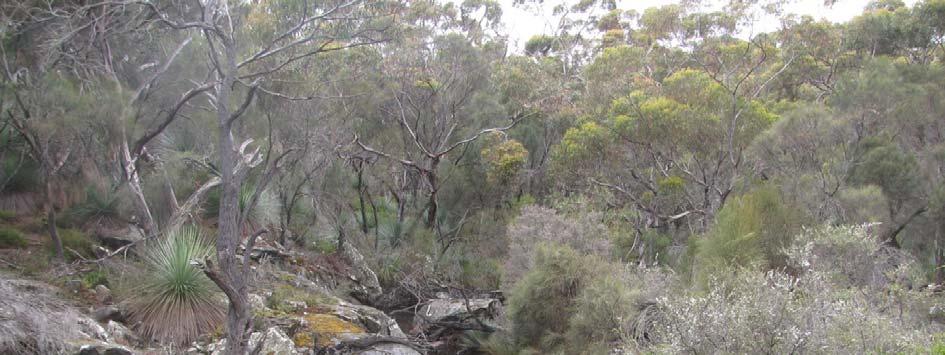
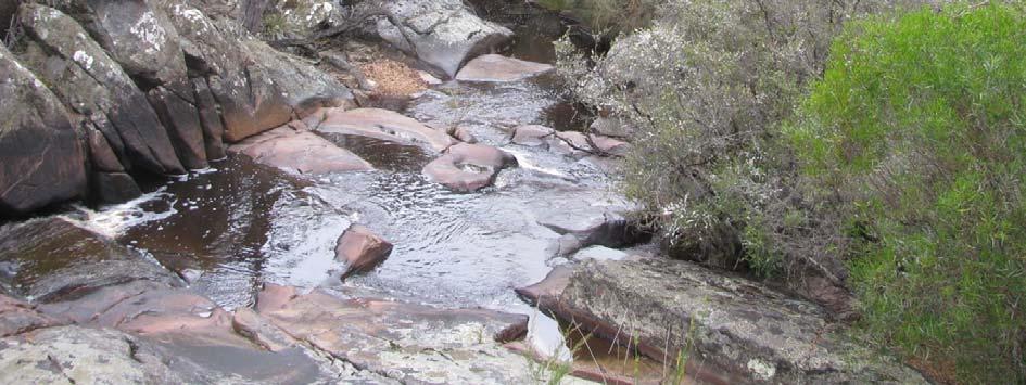
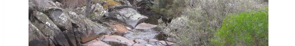
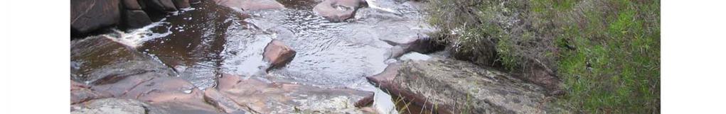
10 3. DESCRIPTION OF THE STUDY AREA Cape Torrens Wilderness Protection Area is located on the north-west coast of Kangaroo Island, approximately 12 kilometres east of Cape Borda, as shown in Figure 1. The proposed addition, Allotment 1 in DP 23502, is located adjacent to the south-eastern boundary and has an area of hectares (Figure 2). Its addition to Cape Torrens Wilderness Protection Area will increase the total area of the park by 18% to 1,107.5 hectares. The addition is almost totally surrounded by remnant native vegetation. In addition to the existing Wilderness Protection Area to the north and west there is a Heritage Agreement bounding much of the southern boundary and large areas of native vegetation to the east and south west. Figure 2. Location of the assessment area 3.1 Biological and Geological Values The proposed addition and the existing park fall within the Stokes Bay Environmental Association, which covers the dissected northern margin of Kangaroo Island s lateritic plateau. The addition features steep-sided hills sloping down to the De Mole River that drains north-east through the area. The area has shallow to moderately deep acidic soils overlying rock, with the deepest soils occurring along the river and its main tributaries. Altitude ranges from a highpoint of around 160 metres on the north-western boundary to 60 metres where the De Mole River exits the area in the north-east. Flora By South Australian standards the western end of Kangaroo Island is a high rainfall region with the Cape Torrens area receiving around 600 mm on average per year. The moist climate supports Addition to Cape Torrens Wilderness Protection Area Assessment Report
 Woodland and Eucalyptus remota (Kangaroo Island Mallee Ash) Open Mallee, interspersed with patches of Allocasuarina verticillata (Drooping Sheoak) Low Woodland, particularly in")

11 woodlands dominated by Eucalyptus cladocalyx ssp. crassa (Sugar Gum) Woodland and Eucalyptus remota (Kangaroo Island Mallee Ash) Open Mallee, interspersed with patches of Allocasuarina verticillata (Drooping Sheoak) Low Woodland, particularly in rocky areas. The eucalypt woodlands occur on hillsides overlooking the De Mole River extending down onto the deeper soils of the river s floodplain where the Sugar Gums grow to over 20 metres in height. Within the Sugar Gum Woodland the shrubby understorey is intact and at times dense, with a deep cover of leaf litter. It features Xanthorrhoea semiplana ssp. tateana (Tate s Grass Tree), Orthrosanthus multiflorus (Morning Flag) and Pteridium esculentum ssp. esculentum (Bracken). The Kangaroo Island Mallee Ash community has a shrubby heath understorey commonly including Tate s Grass Tree, Allocasuarina striata (Stalked Oak-bush), Banksia marginata (Silver Banksia), B. ornata (Desert Banksia) and Hakea rostrata (Beaked Hakea). This addition contains a significant length of the De Mole River and its protection, in conjunction with the existing Cape Torrens Wilderness Protection Area and an adjacent Heritage Agreement, will see the majority of this river s catchment conserved within protected areas. This is a very rare opportunity for South Australia. Contained within the De Mole River and its tributaries are examples of two ecological communities considered to be endangered in South Australia - Leptospermum lanigerum (Silky Tea-tree) Closed Shrubland in non-saline wetlands and Triglochin procera (Water-ribbons) Herbland in freshwater wetlands. Both of these communities have experienced severe decline within their original range due to clearance, physical disturbance by introduced herbivores, weed invasion, salinity and increased nutrients in run-off from agricultural land. The undisturbed nature of the De Mole River catchment has allowed these communities to survive here in good condition. Leptospermum lanigerum (Silky Tea-tree) Closed Shrubland in a tributary of the De Mole River (N. Neagle, DEWNR). Triglochin procera (Water-ribbons) Herbland in a pool within the De Mole River (N. Neagle, DEWNR). Addition to Cape Torrens Wilderness Protection Area Assessment Report
 are of conservation significance, including two at the national level: Hindmarsh Correa (Correa calycina var.")
.")
12 A high diversity of native plant species are known to occur in the assessment area (or in similar habitats within a 1 km radius), with 194 taxa having been recorded. Many of these (70 taxa, or 36%) are of conservation significance, including two at the national level: Hindmarsh Correa (Correa calycina var. halmaturorum) and Splendid Bush-pea (Pultenaea villifera ssp. glabrescens) are both nationally vulnerable. A further 14 taxa are rated at State level and another 54 at the regional level (Gillam and Urban 2014). A list of native plant species recorded in or near the assessment area is provided in Appendix D, with an explanation of conservation status codes in Appendix E. The variety of Hindmarsh Correa found on Kangaroo Island is often referred to as the De Mole River Correa due to its only known occurrences being in close proximity to this watercourse (Taylor 2008). It has been recorded on the banks of the river in Sugar Gum Woodland (Kinnear et al. 1999) within Cape Torrens Wilderness Protection Area as well as in the Heritage Agreement adjacent to the southern boundary of the assessment area. As no active searching has occurred within the assessment area the De Mole River Correa s presence cannot be confirmed here. However, given that the assessment area contains a substantial length of the De Mole River, and thus suitable habitat within the known area of occurrence, its presence here is considered to be highly likely. Similarly, the Splendid Bush-pea is known to occur on sea cliffs and the upper slopes of ridge systems in sandy loam soil along the northern coast of Kangaroo Island (Taylor 2008). The assessment area contains suitable habitat in good condition within this species known area of occurrence and its presence is also considered to be highly likely. Fishbone Water-fern (Blechnum nudum), Rare in SA. Growing on banks of De Mole River (N. Neagle, DEWNR). Splendid Bush-pea (Pultenaea villifera ssp. glabrescens) (D. Kraehenbuehl). Fauna As the proposed addition is contiguous with the existing park, with which it shares a long boundary, many of the fauna species known to occur in the park are highly likely to also be present in the addition. At least 66 fauna species (one fish [in the De Mole River], three frogs, 52 birds, seven mammals and three reptiles) have been recorded in the assessment area (or in similar habitats within a 1 km radius). Of these, one is of conservation significance at the national level, a further eight at State and nine more at regional level (Gillam and Urban 2014). A list of native fauna species recorded in or near the assessment area is provided in Appendix D. The Sugar Gum and Drooping Sheoak Woodlands provide important breeding habitat and food source for the nationally endangered Glossy Black Cockatoo (Calyptorhynchus lathami halmaturinus). The cockatoos feed principally on the seed of the Drooping Sheoak and nest in Addition to Cape Torrens Wilderness Protection Area Assessment Report
, wildfire, predation at nests by Common Brushtail")
 requires large patches of native vegetation with healthy termite mounds (in which they lay their eggs) for its survival.")
13 large tree hollows, usually in Sugar Gums. The major threats to Glossy Black-Cockatoo survival on Kangaroo Island are loss or degradation of habitat (including forage and nesting sites), wildfire, predation at nests by Common Brushtail Possums, competition for nesting sites with other cockatoo species and feral bees, and a shortage of trees with suitable nesting hollows (Mooney and Pedler 2005). The Heath Goanna (Varanus rosenbergi) requires large patches of native vegetation with healthy termite mounds (in which they lay their eggs) for its survival. Although more prevalent on Kangaroo Island than elsewhere in the State, this species is still suffering decline here due to reduction in habitat, loss of adequate termite mounds, predation by cats and dogs, and road mortality. Extensive areas of remnant native vegetation in good condition such as that found in Cape Torrens Wilderness Protection Area and the proposed addition are vital to its survival. Minor disturbance at the site A single unsealed 4WD track traverses the south-eastern boundary of the assessment area. It leads to a small clearing (approximately 0.8 hectares) where a transportable house has been installed. This site, in the south-eastern corner of the area, is also the only section that abuts cleared land. The track impacts in a very minor way on the wilderness values of the land. Glossy Black Cockatoo (Calyptorhynchus lathami halmaturinus) (L. Pedler). Heath Goanna (Varanus rosenbergi) (H. Stewart, DEWNR). Fire Fires generally start through lightning strikes. Given the rugged terrain and inaccessibility of most of the assessment area and Cape Torrens Wilderness Protection Area, individual fires may potentially burn large areas. Fortunately, this has not happened in recent years with the area avoiding the major Flinders Chase fire of The assessment area has not been burnt in over 50 years, as is evidenced by the mature woodland vegetation throughout. The 4WD track located on the southern boundary provides important access for fire control. Addition to Cape Torrens Wilderness Protection Area Assessment Report
14 3.2 Cultural Heritage Aboriginal Heritage Kangaroo Island is known to be of importance to the Kaurna, Ngarrindjeri, Narungga and Ramindjeri people, as they maintain a spiritual connection to the area. Aboriginal artefacts have been reported in Cape Torrens Wilderness Protection Area, but no specific sites have been identified (DEH 2006). The identification and protection of significant sites are important management objectives for the park. No information is available on the Aboriginal heritage of the assessment area at this time. 3.3 Current Management Framework Cape Torrens Wilderness Protection Area was proclaimed to protect its wilderness qualities - remoteness and natural attributes and is managed under the Wilderness Protection Act The Cape Torrens and Western River Wilderness Protection Areas Management Plan (DEH 2006) covers this park. No management plan, as yet, applies to the assessment area. Should this site become part of the Cape Torrens Wilderness Protection Area the existing management plan may require updating, however the provisions of this plan, with its focus on protection of wilderness values, can be applied to the addition. The existing park management plan for Cape Torrens WPA and Western River WPA can be viewed at and a summary of management strategies for Cape Torrens WPA from this plan is provided in Appendix F. 3.4 Resource Utilisation Mining Cape Torrens Wilderness Protection Area is unavailable for exploration, prospecting and mining under State mining legislation. No current mineral exploration licences exist over the assessment area. Previous licences, however, have included this area, with the most recent expiring in May It is unknown if any mineral exploration was carried out within the assessment area, although no evidence has been sighted. In March 1990 the then Department of Mines and Energy conducted drilling along Jump Off Road, but not within the assessment area. Once the area is proclaimed as a WPA, it will no longer be available for mining. Visitor Use There are no constructed walking trails within either Cape Torrens Wilderness Protection Area or the assessment area. A 4WD track runs through the assessment area with a steel bridge installed at a crossing of the De Mole River. The track leads to a transportable house in a clearing near the eastern boundary of the area. From here an old fire track leads 200 metres to the De Mole River. Away from this track visitor access requires advanced skills in navigation and bushwalking. It is intended that access by the public to the assessment area will be consistent with that of the existing Cape Torrens WPA, namely that existing trails can provide walking access consistent with maintaining wilderness quality. The 4WD track will be maintained for fire access, but the entry gate at Jump Off Road will remain locked to prevent access by vehicles and the general public. Commercial Tourism The existing management plan does not provide for commercial tourism within Cape Torrens WPA. There are, however, numerous nature-based tourism opportunities elsewhere on Kangaroo Island, including within other Wilderness Protection Areas such as nearby Western River WPA and Ravine des Casoars WPA. Opportunities within Cape Torrens WPA and the assessment area are limited Addition to Cape Torrens Wilderness Protection Area Assessment Report

 Low Woodland over Tate s Grass Tree (Xanthorrhoea semiplana ssp.")
15 due to the dearth of tracks. Any future proposals should be sympathetic to the area s wilderness values. Sugar Gum (Eucalyptus cladocalyx ssp. crassa) Low Woodland over Tate s Grass Tree (Xanthorrhoea semiplana ssp. tateana) (N. Neagle, DEWNR). Addition to Cape Torrens Wilderness Protection Area Assessment Report
16 4. WILDERNESS ASSESSMENT The high wilderness quality of the assessment area appears to be the result of very limited postsettlement land use. Prior to purchase, the area was privately managed for conservation for over 20 years. There is no evidence of stock grazing and it appears to have experienced very little disturbance other than a single vehicle track and a small clearing containing a transportable house. The area is bordered by Cape Torrens Wilderness Protection Area to the north, a Heritage Agreement adjoining much of the southern boundary, and unprotected native vegetation on the eastern and south-western boundaries. The wilderness assessment process is outlined in Appendix A. 4.1 Wilderness Protection Act 1992 Criteria There are two wilderness criteria set out in Section 3(2) of the Wilderness Protection Act The first criterion states that: The land and its ecosystems must not have been affected, or must have been affected to only a minor extent, by modern technology. The National Wilderness Inventory assesses this criteria using three parameters which are remoteness from access, remoteness from settlement and apparent naturalness. Remoteness from Access There is a single unsealed 4WD track traversing the assessment area. Access is from Jump Off Road on the western boundary and it leads to a transportable house in a small clearing near the eastern boundary. This track largely follows the southern boundary with a short deviation of just less than one kilometre to avoid the De Mole River. Another short track, unmaintained and partly overgrown, leads from the house to the De Mole River (approximately 200 metres). The entrance gate to the 4WD track will be locked to prevent vehicle access by the general public, thereby restricting access to walkers only. Remoteness from Settlement There are no permanent settlements within the assessment area. The nearest town is Parndana, 44 km to the east. The assessment area is largely surrounded by protected remnant native vegetation Cape Torrens Wilderness Protection Area to the north and a privately-owned Heritage Agreement (set aside under the Native Vegetation Act 1991) to the south. Privately-owned unprotected native bush is adjacent to both the eastern and south-western boundaries. A short (500 metre) section of the southern boundary adjoins cleared agricultural land. Adjacent to the eastern boundary is the De Mole River Estate Subdivision, an area of hectare allotments featuring houses set amongst undeveloped native vegetation. Apparent Naturalness The assessment area features intact remnant native vegetation in good condition. The only structure present is a transportable house in a small clearing near the eastern boundary. This was used for occasional holiday visits by the former owner. The house will remain in situ in the short term for management purposes, though its presence may be reviewed in future. The second criterion set out in the Wilderness Protection Act 1992 states that: The land and its ecosystems must not have been seriously affected by exotic animals or plants or other exotic organisms. Addition to Cape Torrens Wilderness Protection Area Assessment Report
17 The National Wilderness Inventory assesses this criteria using the parameter of biophysical naturalness. Biophysical Naturalness The vegetation of the assessment area is in good condition and includes relatively undisturbed examples of high rainfall woodlands (rarely seen in South Australia) and two ecological communities considered to be endangered in South Australia. The prospect for long-term maintenance of the high value of these communities is enhanced by the area s contiguity with other minimally disturbed native vegetation, especially Cape Torrens WPA, a factor that aids its resilience and capacity to absorb large-scale perturbations. Of the 207 plant species recorded in the assessment area (or within similar habitats within a 1 km radius) only 13 are introduced. This is a very low percentage (6.3%) of the total flora and none appear to be widespread. In addition, none are listed as pest plants under the Natural Resource Management Act 2004 or as Weeds of National Significance (Australian Weeds Committee 2012). A total of 70 fauna species have been recorded in the assessment area (or within similar habitats within a 1 km radius). Of these, only four (5.7%) are introduced Feral Goat, Feral Pig, Feral Cat and Common Starling. The size of local populations of each are unknown, but little recent evidence of either goats or pigs was observed during an inspection in November Marron (an exotic crustacean) has also been recorded in the area. The major impacts associated with these species are:- Feral Pig activity can cause major soil disturbance impacting native herbs and providing conditions suitable for the spread and establishment of exotic plants, particularly in the alluvial soils beside the De Mole River; Feral Goat grazing can also cause soil disturbance plus the decreased abundance and distribution of palatable native plant species and the potential spread of weeds; Feral Cats prey on a wide variety of native fauna species; Marron in the De Mole River may compete with and displace native species and degrade watercourse habitat. Fortunately none of these species appear to be present in significant numbers. Phytophthora is an introduced soil-borne pathogen that kills a wide range of native plant species by attacking their root system and reducing or stopping the movement of water and nutrients within the plant. While there has been no sampling for Phytophthora within the assessment area, it has been detected in soil at the northern end of Jump Off Road near the boundary of both this area and the existing Cape Torrens Wilderness Protection Area. Surveys prior to the release of the park management plan (DEH 2006) indicated that Cape Torrens Wilderness Protection Area was free of the disease at that time. The plan did, however, suggest steps were needed to prevent it entering the reserve. The main threat is from people and vehicles entering the area that have not followed appropriate hygiene protocols. No evidence of its spread was observed during the 2013 inspection by DEWNR staff in preparing this report. Addition to Cape Torrens Wilderness Protection Area Assessment Report
18 5. RECOMMENDATIONS 5.1 Land that Meets the Wilderness Protection Act 1992 Criteria The assessment area both meets the wilderness criteria of the Wilderness Protection Act 1992 to a sufficient extent to justify protection under the Act, and to enable the adoption of convenient boundaries of the Cape Torrens Wilderness Protection Area. It is therefore recommended that the assessment area (Allotment 1 in Deposited Plan Number 23502) be added to Cape Torrens Wilderness Protection Area. 5.2 Benefits of Protection Under the Wilderness Protection Act 1992 Protection of the wilderness values identified for this area under the Wilderness Protection Act 1992 will: a) improve the adequacy of South Australia s reserve system by establishing a substantial strictly protected reserve in the Kanmantoo Bioregion; b) conserve high quality tall woodlands, two threatened ecological communities, high native species diversity and a significant portion of the De Mole River. The protection of the river and its catchment will help to maintain its biological integrity and enable it to support associated threatened ecological communities. Its addition to the Cape Torrens Wilderness Protection Area presents a unique opportunity in South Australia to protect virtually all of a river s catchment within a strictly protected reserve; and c) protect virtually all of the known range of the De Mole River Correa. Addition to Cape Torrens Wilderness Protection Area Assessment Report
19 BIBLIOGRAPHY Australian Weeds Committee (2012), Weeds of National Significance. Department of Agriculture, Fisheries and Forestry. Canberra, ACT. DEH (2006) Cape Torrens and Western River Wilderness Protection Areas Management Plan. Adelaide, South Australia. Gillam, S. and Urban, R. (2014) Regional Species Conservation Assessment Project, Phase 1 Report: Regional Species Status Assessments, Kangaroo Island NRM Region. Department of Environment, Water and Natural Resources, South Australia. International Union for the Conservation of Nature [IUCN] (2001) IUCN Red List Categories and Criteria. Version 3.1. IUCN Species Survival Commission, IUCN, Gland, Switzerland and Cambridge, UK. IUCN (2008) IUCN Red List Categories. Prepared by the IUCN Species Survival Commission. IUCN, Gland, Switzerland. Kinnear, A., Carruthers, S., Goodwins, D., Lang, P. and Robinson, A. (1999) Results: Vegetation. In A Biological Survey of Kangaroo Island, South Australia. (Eds. Robinson, A.C. and Armstrong, D.A.), pp65-158, (Department for Environment, Heritage and Aboriginal Affairs, South Australia). Mackey, BG, Lesslie, RG, Lindenmayer, DB, and Nix, HA (1998) Wilderness and its place in nature conservation in Australia. Pacific Conservation Biology 4(3): Mooney, P.A. and Pedler, L.P. (2005) Recovery Plan for the South Australian subspecies of the Glossy Black-Cockatoo (Calyptorhynchus lathami halmaturinus): Department for Environment and Heritage, South Australia. Taylor, D.A. (2008) Draft Recovery Plan for 15 Nationally Threatened Plant Species on Kangaroo Island, South Australia (2nd Edition): Department for Environment and Heritage, Government of South Australia. Addition to Cape Torrens Wilderness Protection Area Assessment Report
20 APPENDIX A: Wilderness Assessment Process 1.1 Wilderness Criteria Section 3(2) of the Act sets out two criteria for determining whether or not land should be regarded as wilderness: (a) the land and its ecosystems must not have been affected, or must have been affected to only a minor extent, by modern technology; (b) the land and its ecosystems must not have been seriously affected by exotic animals or plants or other exotic organisms. The criteria are not a definition of wilderness, but rather describe the attributes land should have to qualify for protection under the Act. The criteria are based on remoteness and naturalness, the indicators of wilderness quality established by the National Wilderness Inventory (1991). The Inventory established the extent and quality of South Australian land with wilderness attributes by measuring variations in naturalness and remoteness across the landscape using four indicators: remoteness from access - the degree of remoteness from established access routes; remoteness from settlement - remoteness from points and areas of permanent human occupation; apparent naturalness - the degree to which the landscape is free from the presence of permanent structures of modern technological society; and biophysical naturalness - the degree to which the natural environment is free of biophysical disturbance resulting from the influence of modern technological society. Remoteness and naturalness are relative terms; no land is absolutely remote or absolutely natural. The wilderness quality of land is assessed in terms of the degree to which it is remote and natural, that is the degree to which it is unaffected by the impacts (including pest plants and animals) of modern technological society. This approach to the assessment of land recognises that there is little, if any, pristine wilderness left, and that land selected is likely to contain some evidence of colonial or modern technological society (such as exotic plants or animals, minor structures from some past land use, or minor tracks). The approach also recognises the increasing value the community places on land that retains a high degree of remoteness and naturalness. It is in this context that the concepts of wilderness protection areas and zones as land management categories have been developed. 1.2 Establishing Boundaries The principle objective in delineating the boundary of a wilderness protection area or zone is to ensure the environmental attributes upon which wilderness quality depends may be effectively managed and protected. It is not necessary for all areas within the wilderness protection area or zone to have high levels of wilderness quality. Areas in which wilderness quality is compromised by accessibility or other disturbances may be included in a wilderness protection area or zone provided the management is designed to protect the integrity of key areas of significant wilderness quality. Boundaries are generally physical boundaries, such as roads and cleared land; forming a tangible and practical divide between areas that will be managed to protect remote and natural qualities, and external areas where development may take place. Addition to Cape Torrens Wilderness Protection Area Assessment Report
21 APPENDIX B: Code of Management for Wilderness Protection Areas and Zones in South Australia 1. INTRODUCTION 1.1 This Code is the Wilderness Code of Management prescribed in the Wilderness Protection Act Any terms used in this Code have the same meaning as those used in the Wilderness Protection Act 1992 and the National Parks and Wildlife Act A wilderness area means land constituted under the Wilderness Protection Act 1992 as a Wilderness Protection Area or Wilderness Protection Zone. 2. OBJECTIVES OF WILDERNESS MANAGEMENT 2.1 To maximise the naturalness and remoteness, i.e. the wilderness quality, of wilderness areas, and in particular: (i) protect and, where practicable, enhance wilderness quality; (ii) protect wildlife and ecological processes; (iii) control and, where practicable, eradicate non-indigenous plants and animals; (iv) protect geographical features; (v) protect sites of scientific significance; (vi) protect sites of historical significance; (vii) protect sites of Aboriginal cultural significance; (viii) provide for public use and enjoyment where compatible with maximising wilderness quality; and (ix) promote public awareness of, and education in, the natural features of and proper use of wilderness protection areas and wilderness protection zones. 3. MANAGEMENT PRINCIPLES 3.1 General Principles (i) All management operations will be carried out in a manner consistent with maximisation of wilderness quality except where provided for in this Code (see 3.10). (ii) A Plan of Management will be prepared for a designated wilderness area as soon as practicable after the area's constitution. The Plan will provide clear direction for the protection and management of the wilderness area, in particular: (a) proposals to achieve the management objectives (2 above); (b) priorities for actions, including: the removal of existing incompatible uses and/or structures except those permitted under this Code; and appropriate rehabilitation to be undertaken following the removal of structures and incompatible uses; (c) recognition of the need to review management if indicated by results of monitoring and research; (iii) No additional incompatible uses and/or structures will be permitted except those provided for in this Code. Addition to Cape Torrens Wilderness Protection Area Assessment Report
22 (iv) Nothing in this Code derogates from any rights exercised in mining tenements in wilderness protection zones. In relation to mining operations in wilderness protection zones, environmental protection policies in section 5 of this Code will apply. 3.2 Access and Transport (i) The use of vessels, motorised or wheeled transport will be permitted only on prescribed access routes, and for emergency and essential management operations (see 3.10) when alternative measures which do not degrade the wilderness quality of an area are unavailable. (ii) Access routes may be prescribed in a plan of management for use by vessels, motorised or wheeled transport in circumstances where this type of transport is essential for effective management. (iii) Construction of vehicle or walking tracks will be permitted only where re-direction of existing access requires construction of alternative tracks or for management works to achieve objectives identified in a plan of management. The construction of vehicle tracks for specific operations as provided for under 3.6(vi), 3.10 and 5.0 may be permitted on the basis that they will be rehabilitated as soon as possible. (iv) Vehicle and walking tracks that are not essential for management purposes as specified in 3.10, or for mining operations in wilderness protection zones (see 5.0) will be closed and rehabilitated as prescribed in a plan of management. (v) Over-flying for recreational purposes under an altitude of 1500m above ground level will be prohibited. (vi) The landing of aircraft will be prohibited, except by permission of the Director and for emergency and essential management operations. Helipads and airstrips that are identified as essential for emergencies and management operations will be maintained. All other strips or helipads will be rehabilitated as soon as possible or allowed to regenerate naturally. 3.3 Tourism (i) Commercial tours may be accommodated where their size and planned activities are compatible with maintenance of wilderness quality. Those permitted will have obtained a licence and will be conducted in accordance with licence conditions, the Visitor Management Strategy for the wilderness area (see 3.4), and the Minimum Impact Code (see Appendix C). Tour groups will be monitored and regulated where necessary to prevent significant adverse impacts on wilderness quality and opportunities for solitude. 3.4 Recreation (i) The level and type of visitor use and visitor conduct will be managed in accordance with the objectives stated in section 2.0 of this Code. (ii) A visitor management strategy that specifies an acceptable level and type of visitor use and visitor conduct will be included in the management plan for each wilderness area. (iii) Visitor management strategies will include the promotion of the Minimum Impact Code and the distribution of any information about the wilderness values of particular wilderness areas. Addition to Cape Torrens Wilderness Protection Area Assessment Report
23 The following information should be used as a basis for monitoring the effectiveness of each strategy: (a) the long-term limits of acceptable change for environmental (wilderness quality) and social (opportunities for wilderness dependent experiences) conditions within the wilderness area; and (b) change in environmental and social conditions within the wilderness area. (iv) Constructed walking tracks, signs, track markers and other management devices or structures will be used only for essential management operations (see 3.2(ii) and 3.10). (v) Recreation will be in accordance with the Wilderness Regulations and the Minimum Impact Code. 3.5 Cultural Heritage (i) Places, sites and objects of significance to Aboriginal people are protected under State and Commonwealth Aboriginal heritage legislation. (ii) Access by Aboriginal people to their sites of significance and protection of these sites will, as far as possible, be by methods compatible with the maintenance of wilderness quality. (iii) Nothing in this Code prevents Aboriginal people from doing anything in relation to Aboriginal sites, objects or remains in accordance with Aboriginal tradition. Furthermore, this Code does not prevent the taking, by Aboriginal people, of native plants, protected animals, or the eggs of protected animals, in accordance with the relevant provisions in the National Parks and Wildlife Act (iv) Sites of historic significance will be conserved, using access and methods compatible with maintenance of wilderness quality in the long-term. (v) Non-Aboriginal structures and artefacts that are of no historic significance, as determined by the relevant authority, will be removed or allowed to deteriorate naturally. Removal will not be undertaken if the only method of removal significantly reduces wilderness quality in the long-term. 3.6 Fire (i) Fire management will be based on continuing research into the fire history of the area, the relationships between fire and the natural communities occurring within the area, and on the maintenance of wilderness quality. (ii) Deliberately lit fires will be used only in emergency situations, and in essential management operations as listed in 3.10 and subject to (i) above. (iii) Other human caused fires should, where practicable, be extinguished consistent with maintenance of wilderness quality. (iv) Naturally caused fires will be extinguished when, in view of the direction, intensity and extent of the fire and the fire suppression techniques available, they pose a threat to human life and property, and to habitats requiring protection. (v) Where fire suppression action is required, the methods utilised will be, wherever possible, those which will have the least long-term impact on wilderness quality. (vi) The use of heavy machinery for fire suppression within a wilderness area will be prohibited except: Addition to Cape Torrens Wilderness Protection Area Assessment Report
Conservation Partners for the National Reserve System Program: a Western NSW focus
 Conservation Partners for the National Reserve System Program: a Western NSW focus Cooper, N. 1, Webber, L. 2, Nicolson, K. 3 1 Department of Environment, Climate Change and Water NSW, PO Box 788 Broken
Priority Species, Communities, Ecosystems, and Threats
 Priority Species, Communities, Ecosystems, and Threats East Gippsland Regional Catchment Strategy 2015/2016 1.0 Objective This document aims to assist in the preparation of project applications for 2015-2016
Biosphere Reserves of India : Complete Study Notes
 Biosphere Reserves of India : Complete Study Notes Author : Oliveboard Date : April 7, 2017 Biosphere reserves of India form an important topic for the UPSC CSE preparation. This blog post covers all important
Assessing and Protecting the World s Heritage. Assessing and Protecting the World s Heritage
 Assessing and Protecting the World s Heritage NEFA BACKGROUND PAPER Assessing and Protecting the World s Heritage Prepared by: Dailan Pugh, 2014 With the NSW opposition parties threatening to open up the
Twelve Apostles Marine National Park Australia
 EVALUATION REPORT Twelve Apostles Marine National Park Australia Location: Victoria, Australia coastal waters Global Ocean Refuge Status: Nominated (2017), Evaluated (2017) MPAtlas.org ID: 7703885 Manager(s):
The South Gippsland Koala. For over 60 years, the plantation industry has shared a unique relationship with the Strzelecki Koala. protection.
 The South Gippsland Koala For over 60 years, the plantation industry has shared a unique relationship with the Strzelecki Koala. protection harmony THE CO-EXISTENCE OF THE KOALA WITH THE PLANTATIONS co-existence
Land Management Summary
 photo credit: ANGAIR Anglesea Heath Land Management Summary The Anglesea Heath (6,501 ha) was incorporated into the Great Otway National Park in January 2018. This provides an opportunity to consider the
Significant Natural Area Assessment. Property Name: Hillend Station
 Private Bag 50072, Queenstown 9348, New Zealand QUEENSTOWN, 10 Gorge Road, Phone +64 3 441 0499, Fax +64 3 450 2223 WANAKA, 47 Ardmore Street, Phone +64 3 443 0024, Fax +64 3 450 2223 Significant Natural
Order of the Minister of Environment #39, August 22, 2011 Tbilisi
 Registration Code 360050000.22.023.016080 Order of the Minister of Environment #39, August 22, 2011 Tbilisi On preparatory stages and procedure of the methodology for Elaborating structure, content and
Watchorn Provincial Park. Management Plan
 Watchorn Provincial Park Management Plan 2 Watchorn Provincial Park Table of Contents 1. Introduction... 3 2. Park History... 3 3. Park Attributes... 3 3.1 Natural... 4 3.2 Recreational... 4 3.3 Additional
Continental Divide National Scenic Trail Legislative History and Planning Guidance
 Continental Divide National Scenic Trail Legislative History and Planning Guidance Legislation, Policy, and Direction Regarding National Scenic Trails The National Trails System Act, P.L. 90-543, was passed
HUT POINT, ROSS ISLAND
 Measure 2 (2005) Annex K Management Plan for Antarctic Specially Protected Area No. 158 HUT POINT, ROSS ISLAND (including Historic Site and Monument No. 18, the historic Discovery hut of Captain R F Scott)
Western Australia The State of Islands
 Western Australia The State of Islands How many islands? There are c. 3700 islands off the coast of WA 2 estimates: 3424 (State), 3747 (Commonwealth) mainly continental islands in State waters, most managed
Terrestrial Protected Area Nomination: Central Mangrove Wetland South-West, Grand Cayman
 Terrestrial Protected Area Nomination: Central Mangrove Wetland South-West, Grand Cayman The attached nomination, proposing that a parcel of land in the Central Mangrove Wetland be made a Protected Area
MANAGEMENT DIRECTION STATEMENT June, 1999
 Thompson River District MANAGEMENT DIRECTION STATEMENT June, 1999 for Roche Lake Provincial Park Ministry of Environment Lands and Parks BC Parks Division Table of Contents I. Introduction A. Setting
WORKSHEET 1 Wilderness Qualities or Attributes Evaluating the Effects of Project Activities on Wilderness Attributes
 WORKSHEET 1 Wilderness Qualities or Attributes Evaluating the Effects of Project Activities on Wilderness Attributes Date: 3/7/2017 Roadless Area: Ruby South Description of Project Activity or Impact to
Pembina Valley Provincial Park. Draft Management Plan
 Pembina Valley Provincial Park Draft Management Plan 2 Pembina Valley Provincial Park Table of Contents 1. Introduction... 3 2. Park History... 3 3. Park Attributes... 3 3.1 Natural... 3 3.2 Recreational...
MANAGEMENT DIRECTION STATEMENT
 Lower Mainland District MAAGEMET DIRECTIO STATEMET January 2001 for Liumchen Ecological Reserve Ministry of Environment Lands and Parks BC Parks Division Table of Contents Page Introduction... 1 Purpose
As outlined in the Tatshenshini-Alsek Park Management Agreement, park management will:
 Management Strategy General Strategy The priority management focus for the park is to ensure that its internationally significant natural, cultural heritage and recreational values are protected and that
4) Data sources and reporting ) References at the international level... 5
 Data sources and reporting ) References at the international level... 5") D- 1: Protected areas (PA) 1) General description... 2 1.1) Brief definition... 2 1.2) Units of measurement... 2 1.3) Context...2 2) Relevance for environmental policy... 2 2.1) Purpose... 2 2.2) Issue...
D- 1: Protected areas (PA) 1) General description... 2 1.1) Brief definition... 2 1.2) Units of measurement... 2 1.3) Context...2 2) Relevance for environmental policy... 2 2.1) Purpose... 2 2.2) Issue...
The Harwood Marine Precinct proposal More bad news for the environment
 The Harwood Marine Precinct proposal More bad news for the environment The Clarence Environment Centre has recently been alerted to a rezoning application to the Department of Planning through the Gateway
Marchand Provincial Park. Management Plan
 Marchand Provincial Park Management Plan 2 Marchand Provincial Park Table of Contents 1. Introduction... 3 2. Park History... 3 3. Park Attributes... 4 3.1 Natural... 4 3.2 Recreational... 4 3.3 Additional
SUBMISSION FROM BIG SCRUB LANDCARE ON THE DRAFT NSW BIODIVERSITY CONSERVATION BILL AND ACCOMPANYING LEGISLATION AND CODES
 TP Draft 23 June 2016 SUBMISSION FROM BIG SCRUB LANDCARE ON THE DRAFT NSW BIODIVERSITY CONSERVATION BILL AND ACCOMPANYING LEGISLATION AND CODES ABOUT THIS SUBMISSION 1. This submission by Big Scrub Landcare
A summary of Draft Makara Peak Mountain Bike Park Master Plan
 A summary of Draft Makara Peak Mountain Bike Park Master Plan OVEMBER 216 Image: Peter Marshall 2 3 Introduction Since it was established in 1998, the Makara Peak Mountain Bike Park (Makara Peak) has grown
158 HUT POINT, ROSS ISLAND
 Measure 13 (2015) Management Plan For Antarctic Specially Protected Area No. 158 HUT POINT, ROSS ISLAND (including Historic Site and Monument No. 18, the historic Discovery hut of Captain Robert Falcon
AMENDMENT NO. 03 TO THE OFFICIAL PLAN FOR THE TOWNSHIP OF ADJALA-TOSORONTIO OAK RIDGES MORAINE CONSERVATION PLAN
 AMENDMENT NO. 03 TO THE OFFICIAL PLAN FOR THE TOWNSHIP OF ADJALA-TOSORONTIO OAK RIDGES MORAINE CONSERVATION PLAN Adopted by Council July 19 th, 2004 Approved with modifications by the Province of Ontario
Parrie Yalloak addition to the Grampians National Park
 Parrie Yalloak addition to the Grampians National Park Values Statement Land Stewardship & Biodiversity Department of Sustainability and Environment May 2005 This Values Statement has been written by James
Draft LAW. ON SOME AMENDAMENTS IN THE LAW No.9587, DATED ON THE PROTECTION OF BIODIVERSITY AS AMENDED. Draft 2. Version 1.
 Technical Assistance for Strengthening the Capacity of the Ministry of Environment, Forests and Water Administration in Albania for Law Drafting and Enforcement of National Environmental Legislation A
National Parks (Wilderness) Act 1992
 Act 1992") No. 40 of 1992 TABLE OF PROVISIONS PART 1 PRELIMINARY Section 1. Purpose 2. Commencement 3. Principal Act PART 2 WYPERFELD NATIONAL PARK 4. Additions to Wyperfeld National Park 5. Deer hunting in Alpine
No. 40 of 1992 TABLE OF PROVISIONS PART 1 PRELIMINARY Section 1. Purpose 2. Commencement 3. Principal Act PART 2 WYPERFELD NATIONAL PARK 4. Additions to Wyperfeld National Park 5. Deer hunting in Alpine
TRAVEL WITH CHRIS BROWN
 TRAVEL WITH CHRIS BROWN ARKABA STATION In South Australia's magnificent Flinders Ranges, one eco tourism company is doing their bit to protect native wildlife. Arkaba Station was once a sheep station but
Potential additions to Aoraki/Mount Cook National Park and the World Heritage Area
 Topic Paper: Potential additions to Aoraki/Mount Cook National Park and the World Heritage Area. Purpose This paper provides the relevant background and matters for consideration regarding potential additions
Whitemouth Falls Provincial Park. Draft Management Plan
 Whitemouth Falls Provincial Park Draft Management Plan Whitemouth Falls Provincial Park Draft Management Plan Table of Contents 1. Introduction... 3 2. Park History... 3 3. Park Attributes... 4 3.1 Natural...
The Conservation Contributions of Ecotourism Cassandra Wardle
 The Conservation Contributions of Ecotourism Cassandra Wardle PhD Candidate, Gold Coast, Australia Supervisors: Ralf Buckley, Aishath Shakeela and Guy Castley State of the Environment State of the Environment
Keeping Wilderness Wild: Increasing Effectiveness With Limited Resources
 Keeping Wilderness Wild: Increasing Effectiveness With Limited Resources Linda Merigliano Bryan Smith Abstract Wilderness managers are forced to make increasingly difficult decisions about where to focus
Appendix 1: Best Management Practices For Hang Gliding and Paragliding in Jasper National Parks
 Appendix 1: Best Management Practices For Hang Gliding and Paragliding in Jasper National Parks Name of Best Management Practice Best Management Practices for Hang Gliding and Paragliding in Jasper National
Wallace Lake Provincial Park. Management Plan
 Wallace Lake Provincial Park Management Plan 2 Wallace Lake Provincial Park Table of Contents 1. Introduction... 3 2. Park History... 3 3. Park Attributes... 4 3.1 Natural... 4 3.2 Recreational... 4 4.
Birch Point Provincial Park. Management Plan
 Birch Point Provincial Park Management Plan 2 Birch Point Provincial Park Table of Contents 1. Introduction... 3 2. Park History... 3 3. Park Attributes... 4 3.1 Natural... 4 3.2 Recreational... 4 4. Park
Michipicoten Island Regional Plan
 Michipicoten Island Regional Plan This is one of twenty Regional Plans that support implementation of the Lake Superior Biodiversity Conservation Strategy (Strategy). The Strategy, prepared and overseen
Wilderness Areas Designated by the White Pine County bill
 Wilderness Areas Designated by the White Pine County bill SEC. 321. SHORT TITLE. This subtitle may be cited as the `Pam White Wilderness Act of 2006'. SEC. 322. FINDINGS. Congress finds that-- The White
RECREATION. Seven issues were identified that pertain to the effects of travel management on outdoor recreation within portions of the project area.
 RECREATION Seven issues were identified that pertain to the effects of travel management on outdoor recreation within portions of the project area. OPPORTUNITIES FOR SOLITUDE / QUIET TRAILS. One attraction
Connie Rudd Superintendent, Black Canyon of the Gunnison National Park
 National Park Service U.S. Department of the Interior Black Canyon of the Gunnison National Park and Curecanti National Recreation Area Information Brochure #1 Wilderness and Backcountry Management Plan
Thematic Report on Mountain Ecosystems. Please provide the following details on the origin of this report. National Focal Point
 Thematic Report on Mountain Ecosystems Please provide the following details on the origin of this report. Contracting Party: Australia National Focal Point Full name of the institution: Department of the
A GUIDE TO MANITOBA PROTECTED AREAS & LANDS PROTECTION
 A GUIDE TO MANITOBA PROTECTED AREAS & LANDS PROTECTION Manitoba Wildands December 2008 Discussions about the establishment of protected lands need to be clear about the definition of protection. We will
Wallace Lake Provincial Park. Draft Management Plan
 Wallace Lake Provincial Park Draft Management Plan Wallace Lake Provincial Park Draft Management Plan Table of Contents 1. Introduction... 3 2. Park History... 3 3. Park Attributes... 4 3.1 Natural...
Lord Howe Island Group native species and ecological communities
 CASE STUDY EXAMPLE OF TRENDS IN SPECIES AND COMMUNITIES NEW SOUTH WALES Lord Howe Island Group native species and ecological communities Description The Lord Howe Island Group is located 760 kilometres
Numaykoos Lake Provincial Park. Management Plan
 Numaykoos Lake Provincial Park Management Plan 2 Numaykoos Lake Provincial Park Table of Contents 1. Introduction... 3 2. Background... 3 3. Park Purpose... 5 4. Park Management Guidelines... 6 Appendix...
Overview. Wilderness Act of Statement of Need. What is Wilderness Character. Monitoring Wilderness Character
 Overview Monitoring Wilderness Character What What & Why? How? How? Conceptual Development How? How? Implementation Future? Future? Troy Hall Steve Boutcher USFS Wilderness & Wild and Scenic River Program
MANAGEMENT DIRECTION STATEMENT June, 1999
 Thompson River District MANAGEMENT DIRECTION STATEMENT June, 1999 for Clearwater River Corridor (Addition to Wells Gray Park) Ministry of Environment Lands and Parks BC Parks Division ii Table of Contents
environmental defender s office new south wales
 environmental defender s office new south wales State Environmental Planning Policy No 44 Koala Habitat Protection December 2010 The EDO Mission Statement To empower the community to protect the environment
Park-specific management and policies Wainuiomata Recreation Area
 Park-specific management and policies Wainuiomata Recreation Area 6.8 Wainuiomata Recreation Area 6.8.1 Legal status Title held: Legislative status: Wellington Regional Council Administered under Local
Yard Creek Provincial Park. Management Plan
 Yard Creek Provincial Park Management Plan Draft January 2010 Yard Creek Provincial Park Management Plan Approved by: telàlsemkin/siyam/chief Scott Benton Bill Williams Squamish Executive Director ation
The Values of the Tasmanian Wilderness World Heritage
 The Values of the Tasmanian Wilderness World Heritage Area The natural and cultural values that have resulted in the TWWHA being reserved as conservation land and inscribed on the World Heritage List are:
33. Coiba National Park and its Special Zone of Marine Protection (Panama) N 1138 rev)
 N 1138 rev)") World Heritage status of the area and the Outstanding Universal Value of the Monarch butterfly migration phenomenon, c) Explore options for the development of non-butterfly related tourism activities;
World Heritage status of the area and the Outstanding Universal Value of the Monarch butterfly migration phenomenon, c) Explore options for the development of non-butterfly related tourism activities;
Title/Name of the area: Chwaka Bay, Zanzibar
 Title/Name of the area: Chwaka Bay, Zanzibar Presented by: Dr. Charles Lugomela, Ag. Head, Department of Aquatic Sciences and Fisheries, University of Dar es Salaam, P.O. Box 35064 Dar es Salaam, Tanzania
OMINEACA PROVINCIAL PARK
 OMINEACA PROVINCIAL PARK AND PROTECTED AREA PURPOSE STATEMENT AND ZONING PLAN March 2003 OMINECA PROVINCIAL PARK AND PROTECTED AREA Purpose Statement and Zoning Plan Omineca Park and Omineca Protected
Tourism and Wetlands
 CONVENTION ON WETLANDS (Ramsar, Iran, 1971) 43 rd Meeting of the Standing Committee Gland, Switzerland, 31 October 4 November 2011 DOC. SC43-27 Tourism and Wetlands Action requested. The Standing Committee
43. DEVELOPMENT AND DISTRIBUTION OF TOURISM
 Tourism Tourism is one of the world s largest industries. In many regions it is also the greatest source of revenue and employment. Tourism demand is based on the values and needs of modern tourists, while
National Parks Association of Queensland Inc. Submission on Waratah Coal Galilee Coal Project Environmental Impact Statement 19 th November 2011
 National Parks Association of Queensland Inc. Submission on Waratah Coal Galilee Coal Project Environmental Impact Statement 19 th November 2011 The National Parks Association of Queensland (NPAQ) is an
Clearwater Lake Provincial Park. Draft Management Plan
 Clearwater Lake Provincial Park Draft Management Plan Clearwater Lake Provincial Park Draft Management Plan Table of Contents 1. Introduction... 3 2. Park History... 4 3. Park Attributes... 4 3.1 Location/Access...4
Hawke s Bay Regional Parks Network. Pekapeka Regional Park Individual Park Plan
 Hawke s Bay Regional Parks Network Pekapeka Regional Park Individual Park Plan 2015-2024 Hawke s Bay Regional Council 159 Dalton Street Private Bag 6006 Napier 4110 Hawke s Bay New Zealand Telephone: 0800
Cooloolabin Dam Recreation Management Discussion Paper. November 2013
 Cooloolabin Dam Recreation Management Discussion Paper November 2013 Contents November 2013... 1 Background... 3 Overview of Cooloolabin Dam... 6 Weed Management... 7 Cultural Heritage... 7 Commercial
Alternative 3 Prohibit Road Construction, Reconstruction, and Timber Harvest Except for Stewardship Purposes B Within Inventoried Roadless Areas
 Roadless Area Conservation FEIS Summary Table S-1. Comparison of Key Characteristics and Effects by Prohibition Alternative. The effects summarized in this table A would occur in inventoried roadless areas
22. Tracking Malleefowl in the Little Desert National Park: A preliminary study of Malleefowl activity in the park
 22. Tracking Malleefowl in the Little Desert National Park: A preliminary study of Malleefowl activity in the park Ralph Patford, Member Victorian Malleefowl Recovery Group Authors: Ralph Patford, Ron
International Union for Conservation of Nature and Natural Resources
 - 156 - APPENDIX XIX International Union for Conservation of Nature and Natural Resources 1110 Morges, Switzerland RESOLUTIONS ADOPTED BY THE TENTH GENERAL ASSEMBLY OF IUCN New Delhi, India, 1 December
We, Ministers, assembled in Berlin for the International Conference on Biodiversity and Tourism from 6 to 8 March 1997
 March 8th, 1997 Berlin Declaration BIOLOGICAL DIVERSITY AND SUSTAINABLE TOURISM We, Ministers, assembled in Berlin for the International Conference on Biodiversity and Tourism from 6 to 8 March 1997 -
Ecological Corridors: Legal Framework for the Baekdu Daegan Mountain System (South Korea) Katie Miller* Kim Hyun**
 Katie Miller* Kim Hyun**") Ecological Corridors: Legal Framework for the Baekdu Daegan Mountain System (South Korea) Katie Miller* Kim Hyun** Information concerning the legal instruments discussed in this case study is current as
Ecological Corridors: Legal Framework for the Baekdu Daegan Mountain System (South Korea) Katie Miller* Kim Hyun** Information concerning the legal instruments discussed in this case study is current as
Appendix F Public authorities responses
 Planning Proposal under sec 55 of the EP&A Act LEP Refinements Appendix F Public authorities responses Appendix F Public authorities responses Prior to public exhibition, consultation was made with the
MANAGING THE RISK TO AVIATION SAFETY OF WIND TURBINE INSTALLATIONS (WIND FARMS)/WIND MONITORING TOWERS.
/WIND MONITORING TOWERS.") NATIONAL AIRPORTS SAFEGUARDING FRAMEWORK GUIDELINE D MANAGING THE RISK TO AVIATION SAFETY OF WIND TURBINE INSTALLATIONS (WIND FARMS)/WIND MONITORING TOWERS. REVISION DATE VERSION NUMBER CHANGES MADE APPROVED
NATIONAL AIRPORTS SAFEGUARDING FRAMEWORK GUIDELINE D MANAGING THE RISK TO AVIATION SAFETY OF WIND TURBINE INSTALLATIONS (WIND FARMS)/WIND MONITORING TOWERS. REVISION DATE VERSION NUMBER CHANGES MADE APPROVED
The Design of Nature Reserves
 The Design of Nature Reserves Goals Maintenance of MVP s for targeted species Maintenance of intact communities Minimization of disease Considerations of reserve design 1. Disturbance regime Fire Insect
Proposed Official Plan Amendment 41 to the Region of York Official Plan
 COMMITTEE OF THE WHOLE NOVEMBER 18, 2002 REGION OF YORK OFFICIAL PLAN AMENDMENT 41 THE OAK RIDGES MORAINE CONSERVATION PLAN Recommendation The Commissioner of Planning recommends: 1. That the City of Vaughan
(4) Protected Areas in Japan 4-1) Outlines of Protected Area Systems in Japan
 Protected Areas in Japan 4-1) Outlines of Protected Area Systems in Japan") (4) Protected Areas in Japan 4-1) Outlines of Protected Area Systems in Japan a) Protected Areas System Under the Nature Conservation Law 1) Wilderness Areas To conserve primeval natural environment, natural
(4) Protected Areas in Japan 4-1) Outlines of Protected Area Systems in Japan a) Protected Areas System Under the Nature Conservation Law 1) Wilderness Areas To conserve primeval natural environment, natural
NATIONAL AIRSPACE POLICY OF NEW ZEALAND
 NATIONAL AIRSPACE POLICY OF NEW ZEALAND APRIL 2012 FOREWORD TO NATIONAL AIRSPACE POLICY STATEMENT When the government issued Connecting New Zealand, its policy direction for transport in August 2011, one
147 (BIS): KAKADU NATIONAL PARK (AUSTRALIA)
: KAKADU NATIONAL PARK (AUSTRALIA)") WORLD HERITAGE NOMINATION - IUCN SUMMARY 147 (BIS): KAKADU NATIONAL PARK (AUSTRALIA) Summary prepared by WCMCIIUCN (March 1992) based on the original nomination submitted by the Government of Australia.
WORLD HERITAGE NOMINATION - IUCN SUMMARY 147 (BIS): KAKADU NATIONAL PARK (AUSTRALIA) Summary prepared by WCMCIIUCN (March 1992) based on the original nomination submitted by the Government of Australia.
Protection of Ulcinj Saline
 Strasbourg, 25 March 2015 T-PVS/Files (2015) 21 [files21e_2015.docx] CONVENTION ON THE CONSERVATION OF EUROPEAN WILDLIFE AND NATURAL HABITATS Standing Committee 35 th meeting Strasbourg, 1-4 December 2015
AMENDMENT #230 TO THE OFFICIAL PLAN OF THE TOWNSHIP OF KING PLANNING AREA
 AMENDMENT #230 TO THE OFFICIAL PLAN OF THE TOWNSHIP OF KING PLANNING AREA Oak Ridges Moraine Conservation Plan Amendment to Township of King Official Plan Amendment #23 (Hamlet Secondary Plan) October
Koala and Greater Glider detection report, Ray s track coupes and , East Gippsland
 Koala and Greater Glider detection report, Ray s track coupes 905-501- 0011 and 905-501- 0010, East Gippsland Surveyors: Rena Gaborov and David Caldwell Report author: Rena Gaborov Report Date: 14/2/17
Ontario s Approach to Wilderness: A Policy May 1997 (Version 1.0)
") Ontario s Approach to Wilderness: A Policy May 1997 (Version 1.0) 1.0. Introduction Wilderness is important to Ontarians, important to the sustained, healthy functioning of Ontario s ecosystems. The Ministry
Ontario s Approach to Wilderness: A Policy May 1997 (Version 1.0) 1.0. Introduction Wilderness is important to Ontarians, important to the sustained, healthy functioning of Ontario s ecosystems. The Ministry
TOWPATH MOWING GUIDELINES
 TOWPATH MOWING GUIDELINES 24 September 2007 CONTENTS Introduction Scope and Status of Guidelines Influences on the Guidelines Health and Safety Biodiversity INTRODUCTION Towpath management is a key issue
Forms of Natural Protection in Greece
 Forms of Natural Protection in Greece 105 th Primary School of Thessaloniki NATIONAL PARKS AND PROTECTED AREAS The irregular and constantly increasing human intervention in nature and the relentless exploitation
 AGREEMENT Between Director of the Białowieża National Park, based in Białowieża (Poland) and Director of the National Park Bialowieża Forest, based in Kamieniuki (Belarus) and Head Forester of the Białowieża
Theme: Predominately natural/natural appearing; rustic improvements to protect resources. Size*: 2,500 + acres Infrastructure**:
 Recreation Opportunity Spectrum (ROS) Classes The Recreation Opportunity Spectrum (ROS) provides a way to describe the variations in the degree of isolation from the sounds and influences of people, and
Rule Governing the Designation and Establishment of All-Terrain Vehicle Use Trails on State Land
 Rule Governing the Designation and Establishment of All-Terrain Vehicle Use Trails on State Land 1.0 Authority 1.1 This rule is promulgated pursuant to 23 V.S.A. 3506. Section 3506 (b)(4) states that an
Hudson Bay Lowlands Proposed Protected Areas
 Hudson Bay Lowlands Proposed Protected Areas Hudson Bay Lowlands Proposed Protected Areas The Protected Areas Initiative has identified portions of the Hudson Bay Lowlands region that have significant
FINAL TESTIMONY 1 COMMITTEE ON RESOURCES UNITED STATES HOUSE OF REPRESENTATIVES. July 13, 2005 CONCERNING. Motorized Recreational Use of Federal Lands
 FINAL TESTIMONY 1 STATEMENT OF DALE BOSWORTH CHIEF Of the FOREST SERVICE UNITED STATES DEPARTMENT OF AGRICULTURE Before the SUBCOMMITTEE ON FORESTS AND FOREST HEALTH And the SUBCOMMITTEE ON NATIONAL PARKS,
KOALA BEACH ESTATE TWEED SHIRE. 20 Years On
 KOALA BEACH ESTATE TWEED SHIRE 20 Years On In the early 1990 s the Australian Koala Foundation (AKF) agreed to work with the Ray Group to create a model for koala-sensitive residential development at Koala
Squirrel Gliders: The Emblem of Informed Sustainability and Better Land Management
 Squirrel Gliders: The Emblem of Informed Sustainability and Better Land Management Ella Corbett, Kira Dawson, Britney Olsson, Zoe Trebilcock, Alan Sandstorm and Melissa Smith Trinity College, Albury-Wodonga
Minimum Requirements References in National Park Service Policy
 Minimum Requirements References in National Park Service Policy 2006 NPS Management Policies Chapter 6: Wilderness Preservation and Management 6.3 Wilderness Resource Management 6.3.1 General Policy (in
Engaging the community as volunteers the case of Lord Howe Island World Heritage Area
 WORLD HERITAGE AND THE COMMUNITY Engaging the community as volunteers the case of Lord Howe Island World Heritage Area Stephen Wills The Lord Howe Island Group (LHIG) is an area of spectacularly beautiful
ADVISORY CIRCULAR ON LAND USE AND ENVIRONMENTAL MANAGEMENT IN THE VICINITY OF AERODROMES
 Page 1 of 9 1.0 PURPOSE 1. The purpose of this Advisory Circular (AC) is to provide guidance on land use practices and activities in the vicinity of aerodromes. 2.0 REFERENCE 2.1 The Civil Aviation (Aerodromes)
NARRABEEN LAGOON SUMMIT am Wednesday, 13 April 2005 Warringah Council Chambers, 725 Pittwater Road, Dee Why.
 NARRABEEN LAGOON SUMMIT 9.15 9.30am Wednesday, 13 April 2005 Warringah Council Chambers, 725 Pittwater Road, Dee Why. NSW Minister for the Environment, the Hon. Bob Debus I am very pleased to be here to
3.12 Roadless Areas and Unroaded Areas
 3.12 Roadless Areas and Unroaded Areas Introduction This analysis focuses on the direct and indirect effects of activities proposed in the Como Forest Health project on roadless area values, including
Decision Memo Broken Wheel Ranch Equestrian Outfitter Special-Use Permit Proposed Action
 Decision Memo Broken Wheel Ranch Equestrian Outfitter Special-Use Permit USDA Forest Service Mississippi Bluffs Ranger District, Shawnee National Forest Jackson and Union Counties, Illinois Proposed Action
MINIMUM REQUIREMENTS DECISION GUIDE WORKSHEETS
 ARTHUR CARHART NATIONAL WILDERNESS TRAINING CENTER MINIMUM REQUIREMENTS DECISION GUIDE WORKSHEETS Prescribed burning of islands within Okefenokee Wilderness Area.... except as necessary to meet minimum
BURGES JAMES GADSDEN PROVINCIAL PARK PURPOSE STATEMENT AND ZONING PLAN
 BURGES JAMES GADSDEN PROVINCIAL PARK PURPOSE STATEMENT AND ZONING PLAN February 2003 BURGES JAMES GADSDEN PROVINCIAL PARK Purpose Statement and Zoning Plan Primary Role The primary role of Burges James
TOWARDS SUSTAINABLE MANAGEMENT OF MARINE AND COASTAL HABITATS ASIA- PACIFIC DAY FOR THE OCEAN
 TOWARDS SUSTAINABLE MANAGEMENT OF MARINE AND COASTAL HABITATS WANNAKIAT THUBTHIMSANG PHUKET MARINE BIOLOGICAL CENTER, DMCR, THAILAND ASIA- PACIFIC DAY FOR THE OCEAN 20 NOVEMBER 2018, CONFERENCE ROOM 4,
52. Richtersveld Cultural and Botanical Landscape (South Africa) (C 1265)
 (C 1265)") 52. Richtersveld Cultural and Botanical Landscape (South Africa) (C 1265) Decision: 32 COM 7B.52 The World Heritage Committee, 2. Having examined Document WHC-08/32.COM/7B.Add, 3. Recalling Decision 31
52. Richtersveld Cultural and Botanical Landscape (South Africa) (C 1265) Decision: 32 COM 7B.52 The World Heritage Committee, 2. Having examined Document WHC-08/32.COM/7B.Add, 3. Recalling Decision 31
Energex Loganlea to Jimboomba Network Upgrade Response to Supplementary IAR. Closes 8 April Submission by
 Energex Loganlea to Jimboomba Network Upgrade Response to Supplementary IAR Closes 8 April 2010 Submission by Logan and Albert Conservation Association Prepared by Anne Page (BA Hons Dip Ed M Env Mgt)
Beaver Creek Provincial Park. Management Plan
 Beaver Creek Provincial Park Management Plan 2 Beaver Creek Provincial Park Table of Contents 1. Introduction... 3 2. Park History... 3 3. Park Attributes... 4 3.1 Natural... 4 3.2 Recreational... 4 4.
Draft Resolution on wetlands in polar and subpolar regions
 RAMSAR CONVENTION ON WETLANDS 54th Meeting of the Standing Committee Gland, Switzerland, 23 27 April 2018 Submitted by Sweden Draft Resolution on wetlands in polar and subpolar regions SC54-Com.15 (21.14)
Sand Lakes Provincial Park. Draft Management Plan
 Sand Lakes Provincial Park Draft Management Plan 2 Sand Lakes Provincial Park Table of Contents 1. Introduction... 3 2. Background... 3 3. Park Purpose... 5 4. Park Management Guidelines... 6 Appendix...