Proposed Subdivision Lots 1 and 4 Narrawallee, NSW
|
|
|
- Veronica Sims
- 5 years ago
- Views:
Transcription

1 Proposed Subdivision Lots 1 and 4 Narrawallee, NSW Archaeological Survey for Aboriginal Sites December 2002 Navin Officer heritage consultants Pty Ltd acn: Jervois St. Deakin ACT 2600 A Report to Rygate & West Pty Ltd ph fx
2 TABLE OF CONTENTS 1. SUMMARY INTRODUCTION REPORT OUTLINE PROJECT PERSONNEL ABORIGINAL PARTICIPATION STUDY METHODOLOGY LITERATURE REVIEW FIELD SURVEY ENVIRONMENTAL CONTEXT ARCHAEOLOGICAL CONTEXT ETHNOHISTORY THE SURROUNDING REGION THE LOCAL AREA PREVIOUSLY RECORDED SITES ABORIGINAL SITE LOCATION CRITERIA SURVEY RESULTS ABORIGINAL SITES SURVEY COVERAGE AND VISIBILITY VARIABLES SIGNIFICANCE ASSESSMENT ASSESSMENT CRITERIA THE STUDY AREA STATUTORY OBLIGATIONS THE NATIONAL PARKS AND WILDLIFE ACT General Management Constraints and Requirements THE NATIONAL PARKS AND WILDLIFE AMENDMENT BILL STATUTORY CONSTRAINTS - BACKGROUND SCATTER IMPLICATIONS FOR THE PROPOSED NARRAWALLEE SUBDIVISION MANAGEMENT OPTIONS & RECOMMENDATIONS REFERENCES APPENDIX I: RECORD OF ABORIGINAL PARTICIPATION... 27
3 1. SUMMARY It is proposed that Lots 1 and 4, west of Leo Drive, Narrawallee, be developed for residential housing. An archaeological assessment of the area was commissioned by Rygate & West and included site register searches, literature review, Aboriginal consultation and field inspection of the study area. Background research indicated that three previously recorded Aboriginal sites, including an open campsite, a midden and an isolated find were located within a kilometre of the study area. No sites had previously been recorded as occurring in the study area Three Aboriginal sites, an open artefact scatter (site NW1) and two isolated finds (NW2 and NW3), were identified in the course of the field inspection of the study area. An area of potential archaeological deposit (PADNW1) was also identified in the northwest corner of the study area. It is recommended that: - If development impact is anticipated in the vicinity of sites NW1, NW2 and NW3 then application should be made to the Director General of the NSW NPWS for Consent to Destroy the sites. - The artefacts at site NW1 and isolated find NW3 should be collected prior to destruction. This collection should be undertaken in cooperation with the ULALC and as a condition of the Consent to Destroy. - If development activities are anticipated in the identified area of archaeological potential PADNW1, then a program of archaeological subsurface testing should be conducted to ascertain the presence/absence, integrity and significance of archaeological material in the area. - There are no Aboriginal archaeological constraints to the proposed residential subdivision development in the remainder of the Narrawallee study area. Navin Officer Heritage Consultants December 2002 page 1
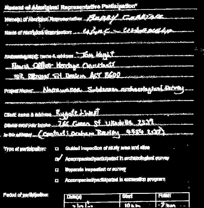
4 2. INTRODUCTION Hazcorp Pty Ltd proposes to develop approximately 23 ha of wooded land at Narrawallee on the NSW south coast as a residential subdivision. The subject area comprises Lots 1 and 4 and is situated south of Narrawallee Creek and directly to the west of Leo Drive (Figures 1 and 2). This report documents the results of an Aboriginal cultural heritage assessment of the subject land. The report was commissioned by Rygate & West Pty Ltd and forms the cultural heritage component of the Development Application (DA) for the proposed subdivision. 2.1 Report Outline This report: Documents consultation with the Ulladulla Local Aboriginal Land Council (ULALC) carried out in the course of the archaeological assessment. Describes the environmental setting of the study area. Provides a background of local and regional archaeology for the study area. Describes the field survey, strategy and results. Provides management recommendations based on the results of the investigation and the anticipated impact of the proposed development on the potential archaeological resource. 2.2 Project Personnel Field survey was conducted by archaeologist Tom Knight and field assistant Daniel Powell. The Ulladulla Local Aboriginal Land Council was represented in the field by Barry Carriage. This report was prepared by Tom Knight. 3. ABORIGINAL PARTICIPATION The study area falls within the boundaries of the Ulladulla Local Aboriginal Land Council (ULALC). The Land Council was contacted by phone prior to the field survey and the project was discussed with Mr Shane Carriage. Subsequently Sites Officer, Mr Barry Carriage, accompanied the archaeologists on the field survey of the study area. Site assessments and recommendations were discussed with Mr Carriage in the field. A copy of this report will be forwarded to the ULALC and a brief report documenting ULALC views has been commissioned from the Land Council. A Record of Aboriginal Participation is provided in Appendix 1. Navin Officer Heritage Consultants December 2002 page 2

 Navin Officer Heritage Consultants December 2002")
5 Archaeological Survey for Aboriginal Sites - Lots 1 and 4 Narrawallee, NSW Figure 1 Location of the Narawallee Study Area (Milton 1:25,000 topo map 2nd ed) Navin Officer Heritage Consultants December 2002 page 3
6 Figure 2 Location of Lots 1 and 4 (plan provided by Rygate & West) Navin Officer Heritage Consultants December 2002 page 4


7 4. STUDY METHODOLOGY 4.1 Literature Review A range of documentation was used in assessing the state of archaeological knowledge for the Narrawallee/Ulladulla area and the surrounding region. Literature sources included the NSW National Parks and Wildlife Service Register of Aboriginal Sites, associated files and catalogue of archaeological reports, and theses held in the library of the Department of Archaeology and Anthropology, Australian National University. This background research was used to determine if known Aboriginal sites were located within the area under investigation, to facilitate site prediction on the basis of known regional and local site patterns, and to place the area within an archaeological and research management context. 4.2 Field Survey Survey was conducted over one day in December Survey involved the field team walking through the study area in systematic and opportunistic survey traverses. Evenly spaced transects were undertaken through the majority of the heavily vegetated terrain in order to capitalise upon any available surface exposures and to identify any old growth trees. All areas of ground disturbance and surface visibility were inspected, the best opportunities encountered in the study area being a series of four wheel drive trails. Creeklines were systematically surveyed. All old growth eucalypt trees were inspected for possible Aboriginal scars. A graphic representation of survey coverage is provided in Figure 3. Figure 3 graphic representation of survey coverage in the study area Navin Officer Heritage Consultants December 2002 page 5
8 5. ENVIRONMENTAL CONTEXT The Narrawallee study area is located within the coastal landforms, estuarine inlets, and low ranges of the NSW South Coast hinterland. The study area is situated in hilly terrain directly to the west of Narrawallee Beach. The surface geology of the small coastal catchments between Narrawallee Creek and the Burrill Lake entrance are dominated by undifferentiated Tertiary sediments, including gravels, sands and clays, sandstone and conglomerates. These facies overlay the Conjola beds that are exposed along the coastline as cliffs along projecting and rocky headlands. Silica-rich rocks such as silcrete and quartzite occur as surface outcrops within the Tertiary sediments, particularly in association with small areas of olivine basalt north of Ulladulla. The Tertiary facies have formed relatively low gradient slopes with open valley floors that include recent aeolian mantles of dune sands. The nearby coastline is characterised by a sequence of rocky headlands and sandy embayments. Bannisters Point, Ulladulla Head, Warden Point and Lagoon Head project into the ocean up to one kilometre and include extensive cliff-lines and intertidal rock platforms. Most of the sandy embayments are associated with freshwater streamlines, and the larger beaches are associated with dune and estuarine barriers behind which coastal lakes and estuaries have formed. Tabourie and Burrill Lakes are all examples of creek valleys which were 'drowned' as a result of the last sea level rise at around BP (years before present). Following the sea level rise, the formation of sand barriers extending from adjacent headlands promoted the development of estuaries and their associated flats. Soils consist of grey sands on the low gradient ridge sides, with the underlying gravelly orange brown clays being apparent at or near the surface along the more exposed ridge top. Topographically the Narrawallee study area encloses a ridgeline with gently sloping sides and a broad crest. The ridgeline comprises a substantial local geographic feature in that it provides a natural route between the elevated terrain around Mollymook to the south, and the low-lying country adjacent to Narrawallee Creek and Narrawallee Inlet to the north. While no readily definable creeklines occur within the study area, a drainage line roughly parallels the area's western boundary. The ridgeline has been subject to forestry activities in the past and several locations along the elevated feature have been quarried. An old quarry is evident at the study area's southern end. Vegetation consists of forest regrowth dominated by turpentine (Syncarpia spp.), Eucalyptus and Angophora species. While the area has been extensively logged in the past, a number of old growth trees remain scattered along the ridge. Navin Officer Heritage Consultants December 2002 page 6
9 6. ARCHAEOLOGICAL CONTEXT 6.1 Ethnohistory Tindale's compilation of tribal boundary information places Narawallee and the surrounding hinterlands in the Wandandian Aboriginal tribal territory. The Wandandian extended down the coast from the Lower Shoalhaven to approximately the Ulladulla region, and westward as far as the Shoalhaven north of Braidwood (Tindale 1974). The language of the Narrawallee/Ulladulla region is placed, with reasonable confidence, in the middle of the Dhurga distribution (Tindale 1974, Eades 1976). Samples of the language spoken by members of the 'Ulladulla tribe' and 'Wandandian tribe' are identified by Mackenzie as Mudthung or Thurumba, now considered to be a northern dialect of Dhurga (Mackenzie 1874, Ridley 1877, Eades 1976). The distribution of the Dhurga language appears to have extended from Jervis Bay down the coast to around Narooma. The Wandandian were part of a larger inter-tribal group, (termed the 'Murring' by Howitt), which formed a community with shared ceremonial obligations and a common initiation lore and cosmology (Howitt 1883, 1904). The Murring extended northward up the NSW coast from around Double Bay to the Shoalhaven, and inland to the Wiradjuri eastern boundary. On initial white settlement the total Aboriginal population of the Ulladulla/Narrawallee region was estimated to be about 600 (Cambage 1916). There is little reference to the relations between the Aboriginal and colonising European cultures. One remaining story relates how the murder of a party of whites, led by Thomas Kendall, an original settler at Narrawallee Creek, was contemplated by a group of Aborigines camped at Ulladulla. The Aborigines had apparently been 'offended' by the actions of a sailor in the party. The party was saved by the warnings of a 'friendly' native who was later favoured by the Kendall family (Cambage 1916:22). The nature of the particular 'offence' can only be guessed at, though the alienation from the most productive tribal hunting grounds must have quickened the dependence of the Aborigines on European foods and the establishment of permanent camps on the fringes of their towns. Thomas Kendall stated that the region's Aboriginal population was divided into two tribes, the Coastal tribe and the Pigeon House tribe, whose territory extended inland to include Braidwood (Hilder 1982, Cambage 1916). He also noted a 'blacks' camp on the north side of Millards Creek which flows into the [Ulladulla] harbour' (Bayley 1983:34). By the 1840's, and certainly the 1850's, the region's Aboriginal population had been reduced to remnant groups either wandering large tracts of the coast, or subsisting at the edge of the now permanent European settlements (Egloff 1981). In 1848 Townsend describes Ulladulla Aborigines employed by settlers to reap crops and fell timber (Townsend 1848). Between 1870 and 1904 various ethnographers and other recorders documented some fragments of traditional life communicated to them by Wandandian People. These people were, at that time, resident at Ulladulla and possibly Wandandian (Mackenzie 1874, Mathews 1904, Etheridge 1904). In 1900 Aborigines camped at the south head of Ulladulla Harbour (Bayley 1975:36). J. E. Mathews (c.1960) recorded that there was no recollection in contemporary local Koori traditions for the use of 'Wandandian' as a tribal name. Nor was there any mention of Aborigines around that time being known by the name 'Wandandian'. Mackenzie (1874) however, has recorded several stories and word lists from individuals he states as belonging to the Wandandian and Ulladulla tribes. It seems possible that these two forms were roughly equivalent to the territorial areas of two different tribal bands on the coastal plain with which the informants identified. Navin Officer Heritage Consultants December 2002 page 7
10 Etheridge recorded information concerning the Aborigines on the sandstone plateau along the Conjola and Wandandian Creeks from a resident at Bar Creek, to the west of the Shoalhaven Gorge. There is no direct reference to rock art sites or their meanings within the ethnographic records of the Ulladulla region. Whilst visiting the Milton district in 1903 or 1904, and after seeing several of the Coles Creek art sites, Etheridge made inquiries about the local art sites to local Aborigines: 'There is still living in the Ulladulla Aborigines Camp an old full-blooded black, known as 'Berrima Jim', who was 'made a man' at the last Bora ceremony held in the Milton District, about forty years ago, and when questioned about this shelter and its pictographs, he knew nothing of them, or professed not to, as the case may be' (Etheridge 1904:80-1). Thus the last traditional initiation or 'Bora ceremony' to be held in the Milton District [which was known about by white people] occurred around 1860 (Etheridge 1904). During the first decades of the twentieth century most European references to the local Wandandian were to note the 'final' passing of a generation of 'full blood' and initiated tribal members (Cambage 1916). However a large Koori population remains in the Milton Ulladulla region today. 6.2 The Surrounding Region The New South Wales south coast and its hinterlands have been the subject of extensive archaeological research over the last thirty years, much of it concentrated along the coastline and estuaries. This includes excavations of Aboriginal sites, mainly shell middens and rock shelters, and detailed and systematic regional surveys. The majority of archaeological sites located in this region date to the last 6,000 years, when the sea levels stabilised to approximately the present level (the Holocene stillstand). Following the stabilisation of sea levels the development of coastal estuaries, mangrove flats and sand barriers increased the resource diversity, reliability, and the potential productivity of coastal environments for Aborigines. In contrast, occupation during the late Pleistocene ie. prior to 10,000 years BP, may have been sporadic and the Aboriginal population relatively small. Sites older than 6,000 years are rare, as most of these would have related to previous shorelines which have now been destroyed or submerged by rising seas. Archaeological investigations in the broader Narrawallee/Ulladulla region include studies carried out in an academic research framework (eg Lampert 1971, White 1987a & b, MacFarlane 1987a & b, Officer 1991a, 1993, Boot 1994), management plans (eg. Officer 1991b) and commercial consulting investigations (eg. Cane 1985a & 1985b, Lance 1987, Kuskie 1995, Stone 1995, Navin 1996a & 1996b, Navin and Officer 1997, Officer & Navin 1998, Navin Officer Heritage Consultants 1999, 2001, 2002). The earliest Aboriginal site recording in the Ulladulla area was carried out in 1918 by Etheridge. A carved tree associated with a bora ground (NPWS Site # ) was recorded about '4 miles WNW of Ulladulla'. According to Etheridge the tree was carved in the 1850's and 'was incised by rings above one another and a spiral cut extended some 10 feet up the tree. The incisions were about four inches broad' (Etheridge 1918:88). The tree is no longer in existence (Bell 1982). In 1971 Lampert conducted excavations into a rockshelter at Burrill Lake which provided basal dates of 20,760±800 years BP (ANU 336), making it the oldest dated site on the NSW south coast. The site provided evidence for 'intensive seaboard exploitation of resources allowing optimum density of settlement' (Mulvaney 1975:244). The earliest dated occurrence of unifacial pebble tools in eastern Australia is from the Burrill Lake rockshelter and the earliest backed blades in the Burrill Lake excavation were dated to around 5300 years BP (Lampert 1971). This date is consistent with the introduction of lithic technologies associated with the 'Bondaian' throughout southeastern Australia. The Burrill Lake Rockshelter site is listed on the Register of the National Estate (Australian Heritage Commission). Navin Officer Heritage Consultants December 2002 page 8
11 Australian National University students participating in field school surveys have located numerous sites in the coastal hinterland and forests around Kioloa and to the west of Burrill Lake/Ulladulla. The results of these surveys have been synthesised by Tom Knight (1996). ANU students Denise White and Ingareth MacFarlane carried out a survey for Aboriginal sites along 38 km of 4x4 and walking tracks and on lakeshores and beach dunes in the Tabourie, Meroo and Willinga Lakes areas (White 1987a, MacFarlane 1987a). MacFarlane noted that in the course of her surveys the only shell middens located close to the surveyed lakes were found cm below the ground surface in excavated waterpipe trenches in Tabourie Lake village. She concluded from this that midden numbers and extent are being considerably underestimated by surface survey technique. In 1987 Denise White located some seventy sites around Burrill Lake in the course of her honours thesis research. Forty eight of these sites were midden sites and seven were midden/open camp sites (White 1987b). Most of White's sites were located on the southern and western shores of the lake. Cane (1985a) carried out a survey of proposed reservoir sites and four water pipeline routes between Lake Conjola and Lake Tabourie. One of these routes (the water pipeline was eventually placed along this route) traverses the STP area under investigation in this report. No sites were located in the study area by Cane. Cane (1985b) also surveyed a 20 km long pipeline from Porters Creek Dam to Ulladulla. No sites were located by Cane along the route, which principally followed existing easements. Cane (1985c) carried out a 'desktop' assessment of the archaeological sensitivity of four possible 132kV transmission line easements west of Ulladulla and north of Burrill Lake and bisected by Stony Creek. He noted that the most archaeologically sensitive area was in the vicinity of Stony Creek and its tributaries where camp sites, middens and grinding grooves may be present. Lance (1987) surveyed a proposed electricity transmission line easement between Nowra and Ulladulla located mostly on the western side of, and parallel to, the Princes Highway. Lance located one artefact scatter and four isolated finds in the course of his survey. Boot (1994) excavated a small rockshelter site, Burrill Shelter 2, on the western side of Burrill Lake. Charcoal from a midden layer in the shelter deposit was dated to around 360 years BP. Earlier dates were obtained from occupation levels below the midden. Kuskie (1995 & addendum) compiled a predictive study for several areas which were under consideration as sites for a landfill facility in the Shoalhaven area. One of these options the Kings Point Drive option included much of the present STP study area. Kuskie concluded that there was 'moderate potential for artefact scatters to occur in the Kings Point Drive option... the potential for other sites types is low with the possible exception of scarred trees, which may occur in stands of mature vegetation' (addendum May 1995:1). A preliminary archaeological survey of the Milton Ulladulla Expansion Area was undertaken by Stone in The subject area comprised a strip of land approximately 5 km wide extending from Croobyar Creek in the north to Burrill Lake and Lagoon Head in the south. The present study area is included within this large area. Stone located five open campsites and two isolated finds. The sites were located near Stony Creek (NPWS Site # & 638), Burrill Lake (# ), Lagoon Head (# ) and Croobyar Creek (# ) (Stone 1995). Navin (1996a) conducted a survey of a proposed Sewage Treatment Plant (STP), access road and a pipeline from the existing Sewage Treatment Plants to a proposed STP site located west of Ulladulla. The STP area consisted of approximately 23 ha of forested ridgeline crest and mid-slopes, and the proposed road and pipeline easements had a combined length of 2.25 km. Two possible Aboriginal scarred trees, Racecourse Creek 1 (NPWS Site # ) and Racecourse Creek 2 (# ), were identified within the general area of the proposed access road and pipeline easements. Navin Officer Heritage Consultants December 2002 page 9
12 No Aboriginal sites were located in the course of a survey for an upgrade and extension of facilities at the West Ulladulla Sporting Complex, located within the northern catchment of Racecourse Creek (Navin 1996b). In summary, over 115 Aboriginal sites have been recorded within the broader Ulladulla/Narrawallee region surrounding the present study area. More than half of these sites are shell middens, mostly located around Burrill Lake, with smaller numbers located around Lakes Tabourie and Termeil and along the coastline. Other site types recorded in the region include open camp sites (16), scarred trees (5), rock shelters with (variously) cultural deposit, art, grinding grooves and midden (7), the recorded location of a carved tree which no longer survives, a quarry site, an open grinding groove site and a stone arrangement. Within the Ulladulla region some landforms with higher archaeological potential, such as the coastline and the Burrill Lake shoreline have been targeted by researchers. Consequently, the recorded distribution of sites within the landscape generally reflects the location of archaeological survey and is not a reliable indication of overall site incidence. 6.3 The Local Area A field inspection of a preferred easement for the proposed Milton Ulladulla Bypass, a short distance to the west of the present study area, was undertaken by Navin & Officer in The easement was approximately 120 m wide and 17 km long. Four Aboriginal sites, comprising two scarred trees and two artefact scatters were located as a result. Four areas of potential archaeological deposit (PADs) were also identified in the road easement (Navin & Officer 1997). An archaeological survey of a residential housing estate located between existing houses along Garside Drive and the Mollymook Hilltop Golf Course at Mollymook was conducted in 1999 (Navin Officer Heritage Consultants 1999). This study was undertaken just over a kilometre to the south of the study area. One possible Aboriginal scarred tree was recorded during the survey. The site was found in a gully mid-slope above a minor drainage line near the northeastern corner of the proposed estate. To the east and south of Leo Drive, surveys and assessments conducted for the Milton/Ulladulla Sewerage Scheme (which serves the area around Ulladulla from Narrawallee in the north to Dolphin Point in the south) resulted in the identification of two new Aboriginal site recordings (both midden sites: MU1 & MU2), and two isolated finds (MU IF1 & MU IF2). Site MU1 (NPWS #?-?-0728) is located approximately 500 m to the north east of the study area. Eleven areas of assessed archaeological subsurface potential were identified (PAD2-12). Five of these locations were considered to have high to moderate archaeological potential, while the remainder had moderate to low potential (Navin Officer Heritage Consultants 2001, 2002). 6.4 Previously Recorded Sites No previously recorded Aboriginal sites are present within the boundaries of the Narrawallee study area. Three sites on the NPWS Register of Aboriginal Sites occur within one kilometre of the limits of the study area; these comprise (an open campsite), (open camp site) and (a midden located to the south of Narrawallee Inlet). An Aboriginal silcrete quarry ( ) is also recorded at Bannisters Point, approximately 1200 metres southeast of the study area's southern boundary. However the site s claimed status as an Aboriginal site has never been adequately supported and cannot be verified. Like all of the many ground surface exposures of silcrete in the Milton-Ulladulla region, the Bannisters Point exposure can only be treated as a potentially utilised source of silcrete during Aboriginal occupation. Based on the surface archaeological evidence at this site, the NPWS site recording can be reliably classified only as a European silica quarry. In terms of its Aboriginal cultural heritage, an archaeological interpretation must be limited to ascribing the status of a probable silica procurement site, which has subsequently been highly modified by European landuse. It has this in common with a large number of other natural surface silcrete exposures in the region. Navin Officer Heritage Consultants December 2002 page 10
13 6.5 Aboriginal Site Location Criteria Extensive archaeological research throughout the south coast region has established a set of generalised criteria for predicting the location of Aboriginal sites within the landforms represented in coastal and immediate hinterland areas (Lampert 1971; Lampert and Sanders 1973; Sullivan 1976; Byrne 1983; Navin 1991, 1993, Knight 1996). Byrne (1983:12-13) suggested that ridgelines provided access routes through the rugged hinterland. Flat areas and saddles were more favoured as site locations for longer term or repeated visits than slopes of more than 15. Closer to the coast, where topographic slopes become more gradual, some drainage lines may have afforded easier access routes, and sites frequently occur on well-drained elevated locations adjacent to wetlands and alluvial flats. Coastal lowland valley floor contexts are likely to have been productive resource zones and subject to considerable animal and plant exploitation by Aboriginal groups. Campsites and activity areas situated on the elevated margins of valley floors probably took advantage of well-drained contexts adjacent to valley floor water sources, the ecotonal diversity of flora and fauna, and specialist exploitation of wetland and alluvial flat resources. The following are a set of predictive statements relevant to the geographic and regional variables of the south coast hinterland. - Open campsites (artefact scatters) are most likely to occur on relatively level, well-drained ground, either adjacent to sources of freshwater and wetlands (drainage lines, lakes and estuaries), or along the crests of ridge and spurlines. Sites on ridge and spurlines are more likely to occur on well-defined crests in topography of moderate or greater relief. - Topographically pronounced ridgelines which afford effective through-access across, and relative to, the surrounding landscape will tend to contain more and larger sites, mostly camp sites evidenced by open artefact scatters. - Estuarine midden sites are normally located close to the estuarine environment, on locally elevated ground. - Coastal middens are frequently located on or near rocky headlands and rock platforms, adjacent to a creek mouth or to hind-dune water sources. - Burial sites are generally found in landforms characterised by a relatively deep profile of soft sediments such as aeolian sand and alluvium. Burials can occur in the deposits of occupation sites such as middens and rockshelters. - Scarred trees may occur in areas of remnant vegetation that contain trees of sufficient age. - Quarry sites are associated with natural outcrops or accumulations of suitable rock types such as fine-grained igneous rocks, quartzites and silcretes. Exposures of silcrete within coastal cliffs, and beach cobble deposits are characteristic quarry site locations on the south coast. Silcrete is the most likely rock type to have been quarried by Aborigines in the Narrawallee/Ulladulla region, with surface outcrops occurring within the Tertiary gravels east of the present Princes Highway, north of Ulladulla. However most surface exposures of this rock type have been quarried for silica during the first half of the nineteenth century. The extent to which evidence for Aboriginal quarrying has survived the European industry is not known, although it is probable that sites would only survive on smaller exposures unexploited by Europeans. - Isolated finds can occur anywhere in the landscape and may represent the random loss or deliberate discard of artefacts, or the remains of dispersed artefact scatters. - The location of sites such as bora grounds and stone arrangements are difficult to predict and are unlikely to have survived within the Narrawallee study area. Navin Officer Heritage Consultants December 2002 page 11
14 7. SURVEY RESULTS 7.1 Aboriginal Sites Three Aboriginal sites were recorded in the Narrawallee study area. They include an artefact scatter and two isolated finds. An area of potential archaeological deposit (PADNW1) was also identified. Locations of the sites and PAD are provided in Figure 4. NW1 - Open artefact scatter GPS NW1 is a scatter of seven stone artefacts exposed on the surface of a four wheel drive track. The site occurs in a low gradient context on the top of the main ridgeline running through the centre of the study area, near the junction of two trails. Site area is approximately 30 x 3 m, with a maximum artefact density of approximately three per square metre at the site's eastern extremity. All artefacts have been manufactured from a grey silcrete consistent in appearance with the naturally outcropping stone at nearby Bannisters Point. The artefacts have been exposed as the result of the grading of the access trail and subsequent erosion of the sandy deposit. Site condition is rated as moderate; while there is some potential for additional artefacts to occur in the surrounding deposits, it is estimated that past landuse (forestry and use of the trail by equipment associated with the nearby quarry) has impacted the location. Consequently there is little potential for in situ archaeological material to be present in this location. Artefact Type Dimensions (mm) Raw Material Comments flaked piece 39 x 24 x 10 grey silcrete core 15 x 30 x 20 grey silcrete one platform, five negative scars flake 29 x 24 x 11 grey silcrete flake 32 x 26 x 11 grey silcrete core 34 x 52 x 42 grey silcrete two platforms, seven negative scars flake 21 x 21 x 6 grey silcrete flaked piece 30 x 15 x 14 grey silcrete NW2 - Isolated find GPS NW2 is a silcrete flake located at the northern edge of the old quarry at the southern end of the study area. Local topographic context is the top of the main south to north trending ridgeline. The artefact is exposed at the base of a coppiced eucalyptus stump which forms a remnant 'island' of the original surface between the graded access track and the extraction zone of the quarry itself. It is possible the artefact represents the remains of a low-density artefact scatter that has been largely destroyed by earthmoving activity. The location is highly disturbed, most of the original deposit having been removed by quarrying. Site condition is consequently rated as poor. Navin Officer Heritage Consultants December 2002 page 12
15 Artefact Type Dimensions (mm) Raw Material Comments flake 12 x 9 x 3 grey silcrete NW3 - Isolated find GPS NW3 is a large silcrete flake exposed by the cutting of a four wheel drive track on the western side of the main ridgeline. The find was made approximately 30 metres uphill of the intersection of two access trails. Substantial artefact dimensions and general morphology is suggestive of a hatchet blank. However, given the flaking characteristics of the silcrete, it is much more likely that the flake was struck from a local stone outcrop and transported across the landscape for future use as a core. The artefact is associated with a grey sandy deposit that has moderate potential to contain additional artefacts in the local slope context. However taking account of the thickness of the sandy soil (<30 cm), the gradient at the location and past forestry practices, there is little potential for in situ archaeological deposit to be present. However, this potential is increased in adjacent down-slope areas where the gradient is greatly reduced and soils may be thicker (see below). Artefact Type Dimensions (mm) Raw Material Comments flake 105 x 160 x 50 grey silcrete probably quarried for use as a core 7.2 PADNW1 - Potential Archaeological Deposit) Potential Archaeological Deposits (PADs) are deposits, usually associated with rock shelters or actively aggrading landform features. They exhibit no identifiable archaeological material on the surface but may contain subsurface material. Potential deposits are usually identified by their context within, or associated with, a landscape feature that was likely to have been exploited in prehistory. The sandy soils to the north of isolated find NW3 have potential to contain additional artefacts and possible in situ archaeological deposit. This identification is made on the basis of: - the presence of Aboriginal sites in adjacent parts of the study area, - the low gradient to level nature of the terrain (ie an aggrading/stable landscape), and - the close proximity of the drainage line to the west which represents a possible source of fresh water. Surface visibility in this part of the study area was universally very low due to thick undergrowth, and opportunities to gauge the deposit's archaeological content by conventional survey were therefore highly restricted. PADNW1 is defined as the low gradient lower slope/ridgeside interface zone commencing to the north of isolated find NW3, with a width of approximately 50 metres from the western boundary. Navin Officer Heritage Consultants December 2002 page 13


16 Archaeological Survey for Aboriginal Sites - Lots 1 and 4 Narrawallee, NSW Figure 4 Location of Aboriginal sites and PAD in the study area Navin Officer Heritage Consultants December 2002 page 14
17 7.2 Survey Coverage and Visibility Variables The effectiveness of archaeological field survey is to a large degree related to the obtrusiveness of the sites being looked for and the incidence and quality of ground surface visibility. Visibility variables were estimated for all areas of comprehensive survey within the study area. These estimates provide a measure with which to gauge the effectiveness of the survey and level of sampling conducted. They can also be used to gauge the number and type of sites that may not have been detected by the survey. Ground surface visibility is a measure of the bare ground visible to the archaeologist during the survey. There are two main variables used to assess ground surface visibility, the frequency of exposure encountered by the surveyor and the quality of visibility within those exposures. The predominant factors affecting the quality of ground surface visibility within an exposure are the extent of vegetation and ground litter, the depth and origin of exposure, the extent of recent sedimentary deposition, and the level of visual interference from surface gravels. Two variables of ground surface visibility were estimated during the survey: - a percentage estimate of the total area of ground inspected which contained useable exposures of bare ground - a percentage estimate of the average levels of ground surface visibility within those exposures. This is a net estimate and accounts for all impacting visual and physical variables including the archaeological potential of the sediment or rock exposed. The obtrusiveness of different site types is also an important factor in assessing the impact of visibility levels. For example, artefacts made from locally occurring rock such as quartz may be more difficult to detect under usual field survey conditions than rock types that are foreign to the area. The impact of natural gravels on artefact detection was taken into account in the visibility variables estimates outlined above. The natural incidence of sandstone platforms suitable for grinding grooves or engraving, together with the incidence of old growth trees, are important considerations in identifying both survey effectiveness and site location patterns outside of environmentally determined factors. The following table summarises estimates for the degree to which separate landforms within the study area were examined and also indicates the exposure incidence and average ground visibility present in each case. A total of 92% of the ground area in the study area was inspected during the survey, with 22% providing useable archaeological exposures. Taking into account survey coverage, archaeologically useable exposures, and visibility variables, the effective survey coverage (ESC) was 13% of the total survey area. The ESC attempts to provide an estimate of the proportion of the total study area which provided a net 100% level of ground surface visibility to archaeological surveyors. The ESC calculation is defined and required by the NPWS and stated to be of use in assessing and cross comparing the adequacy of archaeological surface surveys. The actual utility of the ESC calculation however is challenged by many archaeologists. The limitations of the ESC calculation are emphasised by differences in the subjective assessment of exposure and visibility levels, variations in how survey units are defined and measured, and differences in how and which variables are estimated and combined. In reality, ESC results tend only to be meaningful when compared across surveys conducted by the same surveyors and ESC measurers. Navin Officer Heritage Consultants December 2002 page 15
18 Table 1: Survey Coverage Data Survey division Survey unit Landform Survey mode Main exposure types Unit area (ha) Proportion of unit surveyed % Exposure incidence % Average exposure visibility % Net effective exposure (ha) Effective survey coverage of survey unit % Archaeological recordings 1 a ridgesides foot bare surfaces NW3 2 a ridgetop foot graded trail NW1, NW2 2 b ridgesides foot graded trail Totals Navin Officer Heritage Consultants December 2002 page 16
19 8. SIGNIFICANCE ASSESSMENT 8.1.Assessment Criteria The Burra Charter of Australia defines cultural significance as 'aesthetic, historic, scientific or social value for past, present and future generations' (Aust. ICOMOS 1987). The assessment of the cultural significance of a place is based on this definition but often varies in the precise criteria used according to the analytical discipline and the nature of the site, object or place. In general, Aboriginal archaeological sites are assessed using five potential categories of significance: significance to contemporary Aboriginal people, scientific or archaeological significance, aesthetic value, representativeness, and value as an educational and/or recreational resource. Many sites will be significant according to several categories and the exact criteria used will vary according to the nature and purpose of the evaluation. Cultural significance is a relative value based on variable references within social and scientific practice. The cultural significance of a place is therefore not a fixed assessment and may vary with changes in knowledge and social perceptions. Aboriginal significance can be defined as the cultural values of a place held by and manifest within the local and wider contemporary Aboriginal community. Places of significance may be landscape features as well as archaeologically definable traces of past human activity. The significance of a place can be the result of several factors including: continuity of tradition, occupation or action; historical association; custodianship or concern for the protection and maintenance of places; and the value of sites as tangible and meaningful links with the lifestyle and values of community ancestors. Aboriginal cultural significance may or may not parallel the archaeological significance of a site. Scientific significance can be defined as the present and future research potential of the artefactual material occurring within a place or site. This is also known as archaeological significance. There are two major criteria used in assessing scientific significance: 1. The potential of a place to provide information which is of value in scientific analysis and the resolution of potential research questions. Sites may fall into this category because they: contain undisturbed artefactual material, occur within a context which enables the testing of certain propositions, are very old or contain significant time depth, contain large artefactual assemblages or material diversity, have unusual characteristics, are of good preservation, or are a constituent of a larger significant structure such as a site complex. 2. The representativeness of a place. Representativeness is a measure of the degree to which a place is characteristic of other places of its type, content, context or location. Under this criteria a place may be significant because it is very rare or because it provides a characteristic example or reference. The value of an Aboriginal place as an educational resource is dependent on: the potential for interpretation to a general visitor audience, compatible Aboriginal values, a resistant site fabric, and feasible site access and management resources. The principal aim of cultural resource management is the conservation of a representative sample of site types and variation from differing social and environmental contexts. Sites with inherently unique Navin Officer Heritage Consultants December 2002 page 17
20 features, or which are poorly represented elsewhere in similar environment types, are considered to have relatively high cultural significance. The cultural significance of a place can be usefully classified according to a comparative scale that combines a relative value with a geographic context. In this way a site can be of low, moderate or high significance within a local, regional or national context. This system provides a means of comparison, between and across places. However it does not necessarily imply that a place with a limited sphere of significance is of lesser value than one of greater reference. 8.2 The Study Area In general, the sites found within the study area typify archaeological trends of the south coast hinterland: small artefact scatters and/or isolated finds located along the tops of the more substantial elevated topographic 'routeways' between ecological zones (cf Knight 1996). In this case the study area sites may be representative of both Aboriginal use of the forest environment and movement between country further inland and the coastal zone, probably the marine/estuarine interface represented by Narrawallee Inlet. NW1 open artefact scatter The site is small and exhibits a low artefact density. Artefact content is largely uniform, primarily consisting of debitage. Site condition is moderate and there is little potential for in situ archaeological material to occur in the relatively thin local surface deposits. Artefact raw material appears to be consistent with local stone procurement. The site is assessed as low local significance. NW2 and NW3 isolated artefacts The artefacts comprise unmodified flaked implements occurring either in isolation or as remnants of dispersed, highly disturbed artefact scatters. Local deposits exhibit little potential to contain undisturbed archaeological deposit. Isolated finds of this type are not normally considered significant based on any of the criteria defined above. Navin Officer Heritage Consultants December 2002 page 18
21 9. STATUTORY OBLIGATIONS The following summary is based on: the provisions of the current National Parks and Wildlife Act 1974 (as amended). It should be noted that amendments to this Act were passed by both houses of the NSW State Government in 2001 (no.130, assented 19/12/2001). A small number of these amendments were proclaimed on 1 July It is anticipated however, that the majority of the amendments will become law sometime in NPWS policy as presented in the 1997 Standards and Guidelines Kit for Aboriginal Cultural Heritage provided by the NSW NPWS, and as communicated orally to the consultants on a periodic basis; and The guideline documents presented in the 1997 Standards and Guidelines Kit were stated to be working drafts and subject to an 18 months performance review. The Standards Manual was defined not to be a draft and subject to periodic supplements. To date, no formal amendments or further drafts have been provided, however the NPWS state that the Kit is currently subject to an internal review. 9.1 The National Parks and Wildlife Act 1974 The National Parks and Wildlife Act 1974 (as amended) provides the primary basis for the legal protection and management of Aboriginal sites within NSW. The implementation of the Aboriginal heritage provisions of the Act is the responsibility of the NSW National Parks and Wildlife Service. The rationale behind the Act is the prevention of unnecessary or unwarranted destruction of relics, and the active protection and conservation of relics that are of high cultural significance. With the exception of some artefacts in collections, or those specifically made for sale, the Act generally defines all Aboriginal artefacts to be relics and to be the property of the Crown. The Act then provides various controls for the protection, management and destruction of these relics. A 'relic' is defined as 'any deposit, object or material evidence (not being a handicraft made for sale) relating to indigenous and non-european habitation of the area that comprises New South Wales, being habitation both prior to and concurrent with the occupation of that area by persons of European extraction' [Section 5(1)]. In practice, archaeologists tend to subdivide the legal category of 'relic' into different site types that relate to the way artefacts are found within the landscape. The archaeological definition of a site may vary according to survey objectives, however a site is not recognised or defined as a legal entity in the Act. It should be noted that even single and isolated artefacts are protected as relics under the Act. Generally it is an offence to do any of the following without a Permit from the Director-General of the NPWS under Section 87: disturb or excavate any land for the purpose of discovering a relic; disturbing or moving a relic; take possession of or removing a relic from certain lands; and erecting a building or structure to store relics on certain land (Section 86). The maximum penalty is $11,000 for individuals and $22,000 for corporations. Section 175B outlines circumstances where corporation directors may be taken to have contravened these provisions, based on the acts or omissions of that Corporation. Consents regarding the use or destruction of relics are managed through a NPWS system of Permits and Consents under the provisions of Sections 87 and 90 of the Act. The processing and assessment of Permit and Consent applications is dependent upon adequate archaeological review and assessment, together with an appropriate level of Aboriginal community liaison and involvement Navin Officer Heritage Consultants December 2002 page 19
22 (refer Standards for Archaeological Practice in Aboriginal Heritage Management in 1997 NPWS Standards and Guidelines Kit). The Minister may declare any place which, in his or her opinion, is or was of special Aboriginal significance with respect to Aboriginal culture, to be an Aboriginal place (Section 84). The Director- General has responsibility for the preservation and protection of the Aboriginal place (Section 85). An area declared to be an Aboriginal place may remain in private ownership, or be acquired by the Crown by agreement or by a compulsory process (Section 145). The Director General may make an interim protection order and order that an action cease where that action is, or is likely to, significantly affect an Aboriginal object of Aboriginal place. Such an order is current for 40 days (Section 91AA, Schedule 3[10]). Such an order does not apply to certain actions, such as where they are in accordance with development consents or emergency procedures General Management Constraints and Requirements The Act, together with the policies of the NPWS provide the following constraints and requirements on landowners and managers: it is an offence to knowingly disturb an Aboriginal artefact or site without an appropriate permit or consent (Section 90); prior to instigating any action which may conceivably disturb a 'relic' (this generally means land surface disturbance or felling of mature trees), archaeological survey and assessment is required (refer Standards for Archaeological Practice in Aboriginal Heritage Management in 1997 NPWS Standards and Guidelines Kit). when the archaeological resource of an area is known or can be reliably predicted, appropriate landuse practices should be adopted which will minimise the necessity for the destruction of sites/relics, and prevent destruction to sites/relics which warrant conservation (refer Standards for Archaeological Practice in Aboriginal Heritage Management in 1997 NPWS Standards and Guidelines Kit). documented and appropriate consultation with relevant Aboriginal Community representatives is required by the NPWS as part of the prerequisite information necessary for endorsement of consultant recommendations or the provision of Consents and Permits by the NPWS (refer Standards for Archaeological Practice in Aboriginal Heritage Management in 1997 NPWS Standards and Guidelines Kit). 9.2 The National Parks and Wildlife Amendment Bill 2001 The National Parks and Wildlife Amendment Bill 2001 is expected to pass into law with its gazettal sometime in The Bill will include the following provisions with regard to Aboriginal cultural heritage: The term relic will be replaced with Aboriginal object (Schedule 1[1]). An Aboriginal object is defined as: any deposit, object or material evidence (not being a handicraft made for sale) relating to the Aboriginal occupation of the area that comprises New South Wales, being habitation before or concurrent with (or both) the occupation of that area by persons or non-aboriginal extraction, and includes Aboriginal remains. The requirement for a Consent to Destroy from the Director General will be replaced by a heritage impact permit (Schedule 3[1], 3[3-8]). Navin Officer Heritage Consultants December 2002 page 20
23 The offence under section 90 of the Principal Act of knowingly destroying, defacing or damaging Aboriginal objects and Aboriginal Places without Consent will be changed so that the element of knowledge will be removed (Schedule 3 [2]). The amended section 90, subsection 1 will read: A person must not destroy, deface, damage or desecrate, or cause or permit the destruction, defacement, damage or desecration of, an Aboriginal object or Aboriginal place. Section 90 subsection 1 will not apply when an Aboriginal object or Aboriginal place is dealt with in accordance with a heritage impact permit issued by the Director-General (Schedule 3[3], Section 90(1B) in amended Act). It will be a defence to a prosecution for an offence against subsection 1 if the defendant shows that: (a) he or she took reasonable precautions and exercised due diligence to determine whether the action constituting the alleged offence would, or would be likely to, impact on the Aboriginal object of Aboriginal place concerned, and (b) the person reasonably believed that the action would not destroy, deface, damage or desecrate the Aboriginal object or Aboriginal place. (Schedule 3[3], Section 90(1C) in amended Act) A court will be able to direct a person to mitigate damage to or restore an Aboriginal object or an Aboriginal place in appropriate circumstances when finding the person guilty of an offence referred to in section 90 of the Principal Act (Schedule 3[9]). Schedule 4[8] of the Bill provides for the Director-General to withhold in the public interest specified documents in the possession of the NPWS which relate to the location of Aboriginal objects, or the cultural values of an Aboriginal place or Aboriginal object. 9.3 Statutory constraints arising from artefacts which constitute background scatter Background scatter is a term used generally by archaeologists to refer to artefacts that cannot be usefully related to a place or focus of past activity. There is no single concept for background scatter or discard, and therefore no agreed definition. The recognition of background material within a particular study area is dependent on an appreciation of local contextual and taphonomic factors. Artefacts within a background scatter can be found in most landscape types and may vary considerably in density. Standard archaeological methodologies cannot effectively predict the location of individual artefacts. Surface survey may detect background material either as individual artefacts ( isolated finds ), or even as small, low-density sites. Subsurface testing may sample, and through analysis, characterise background material. However, beyond the scope of archaeological sampling, the potential to encounter background artefacts within the context of development related ground disturbance will always remain. There is generally no scientific justification for the conduct of ground disturbance monitoring to effect the recovery of background artefacts. The intrinsic scientific value of any recovered artefacts does not, in general, outweigh the expense of conducting the monitoring. However, the monitoring of ground works by Aboriginal groups is now increasingly practiced. The recovery of background scatter artefacts is the most probable outcome of such monitoring exercises. Given the nature of statutory and NPWS policy requirements in NSW (refer Section 9), the detection of background artefacts during monitoring can be problematic. Unless the relic (or Aboriginal object) is covered by a current Consent or Permit (or Heritage Impact Permit (HIP)), from the NPWS, all further impact to the find, and the ground in its immediate vicinity, must cease until one is gained. It may take up to eight weeks for this to occur. In the past, however, the NPWS has not as a general rule granted Consents to cover artefacts within background scatters. This is because the NPWS only Navin Officer Heritage Consultants December 2002 page 21
24 provide Consents where the significance and location of the relics to be impacted can be reliably defined. By their very nature, this cannot be done for artefacts that constitute a background scatter. The present policies of the NPWS do not provide an effective or pro-active means of dealing with the statutory constraints posed by the detection of background scatter artefacts during development works. It should therefore be noted, that in the event that an Aboriginal artefact ( relic or Aboriginal object ) is detected during monitoring of ground disturbance within a development study area, and that area is not covered by a Consent to Destroy (or Heritage Impact Permit), there may be considerable delays to development works while an application for a Consent to Destroy is processed. 9.4 Implications for the Proposed Narrawallee Subdivision Aboriginal relics, as defined under the NPW Act, have been identified within the Narrawallee study area. This means that, prior to any development activities being carried out in the areas where relics are present, a Consent to Destroy will be required from the NSW NPWS. Consents to Destroy can be obtained by making an application to the Director General of the NSW NPWS. Navin Officer Heritage Consultants December 2002 page 22
25 10. MANAGEMENT OPTIONS & RECOMMENDATIONS Aboriginal sites NW1, NW2 and NW3 and the area of archaeological potential PADNW1 are potentially threatened by the proposed residential subdivision development. Options generally available for the management of archaeological sites include conservation, archaeological control, archaeological recording followed by salvage of materials (collection, excavation), or no further action to be taken. Recording and salvage may be recommended for sites where the original form or fabric has been disturbed or damaged but where significant, moveable material cultural remains may exist and may be appropriately conserved in another setting. Based on their potential to contain information relating to the stone reduction sequence in and around the Ulladulla area, salvage collection is recommended for sites NW1 (open artefact scatter) and NW3 (isolated find). No further action to be taken is the option recommended for sites of low or negligible cultural heritage significance. This option is recommended for site NW2 (isolated find). Further archaeological investigation is recommended in the case of PADNW1. The potential scientific significance of any additional stone artefacts in concentration and/or stratified context in the area is supplemented by Aboriginal concerns for potential occurrence of undisturbed sites. Mr Barry Carriage of the ULALC voiced specific concerns over the comparatively thicker soil deposits in this general area. It is recommended that: 1. If development impact is anticipated in the vicinity of sites NW1, NW2 and NW3 then application should be made to the Director General of the NSW NPWS for Consent to Destroy the sites. 2. The artefacts at site NW1 and isolated find NW3 should be collected prior to destruction. This collection should be undertaken in cooperation with the ULALC and as a condition of the Consent to Destroy. 3. If development activities are anticipated in the identified area of archaeological potential PADNW1, then a program of archaeological subsurface testing should be conducted to ascertain the presence/absence, integrity and significance of archaeological material in the area. The testing would involve mechanical excavation of a series of test pits in the PAD. A NPWS Preliminary Research Permit (PRP) will be required to conduct this investigation. 4. There are no Aboriginal archaeological constraints to the proposed residential subdivision development in the remainder of the Narrawallee study area. 5. Three copies of this report should be forwarded to the NSW NPWS at the following address for review and comment: Aboriginal Heritage Officer Southeastern Directorate NSW National Parks & Wildlife Service PO Box 2115 QUEANBEYAN NSW One copy of this report should be forwarded to: The Secretary Ulladulla Local Aboriginal Land Council PO Box 520 Ulladulla NSW 2539 Navin Officer Heritage Consultants December 2002 page 23
26 11. REFERENCES Australia ICOMOS 1987 The Australia Icomos Charter for the Conservation of Places of Cultural Significance (The Burra Charter), Guidelines to the Burra Charter: Cultural Significance and Conservation Policy. Pamphlet, Australia Icomos (Inc). Bayley, W. A Shoalhaven South Coast Printers, Port Kembla, NSW. Bell, D Aboriginal Carved Trees of Southeastern Australia. A research report to NSW NPWS. Boot, P Recent research into the prehistory of the hinterlands of the south coast of New South Wales. In Sullivan, M., S. Brockwell and A. Webb (eds) Proceedings of the 1993 Australian Archaeological Association Conference. NARU, Darwin. Cambage, R. H Captain Cook's Pigeon House, and the Early South Coast Exploration. Samuel E. Lees Printers and Stationers, Sydney, 24pgs. Cane, S. 1985a An Archaeological Survey of Pipeline Routes and Reservoir Sites Between Lake Conjola and Lake Tabourie, NSW. Report to Shoalhaven City Council. Cane, S. 1985b An Archaeological Survey of Pipeline Route and Proposed Dam Site for the Southern Shoalhaven Water Supply Scheme, Near Ulladulla, NSW. Report to NSW Dept of Public Works. Cane, S. 1985c Archaeological Sensitivity Investigation. Report by ANUTECH to Dames & Moore Pty Ltd. Eades, D. K The Dharrawal and Dhurga Languages of the New South Wales Coast. Australian Aboriginal Studies, Research and Regional Studies no. 8, Australian Institute of Aboriginal Studies, Canberra. Egloff, B. J Wreck Bay an Aboriginal Fishing Community. Australian Institute of Aboriginal Studies, Canberra. Etheridge, R A Remarkable Rock-Shelter in the Milton District, New South Wales. Records of the Australian Museum 5: Etheridge, R Memoirs of the Geological Survey of NSW. Ethnological Soc. No 3, p88. Hilder, W Historical Background. In Watson, C. (Ed.) Pigeon House and Beyond: A Guide to the Budawang Range and Environs. The Budawang Committee, Eastwood, NSW. Ch.1 pp Howitt, A. W On Some Australian Beliefs. Journal Anthropological Institute 13: Howitt, A. W The Native Tribes of South-East Australia. Macmillan & Co. London. Knight, T The Batemans Bay Forests Archaeological Project - Site Distribution Analysis. Research Report. Unpublished report, Department of Archaeology and Anthropology, The Faculties, ANU, Canberra. Kuskie, P A Predictive Archaeological Study of options for the Proposed Southern Shoalhaven Landfill Facility, South Coast New South Wales. Report to Shoalhaven City Council. Lampert, R Burrill Lake and Currarong. Coastal Sites in Southern NSW. Archaeology and Physical Anthropology in Oceania 9: Navin Officer Heritage Consultants December 2002 page 24
27 Lampert, R. and F. Sanders 1973 Plants and Men on the Beecroft Peninsula, New South Wales. Mankind 9: Lance, A An Archaeological study of the Proposed Shoalhaven to Ulladulla 132kV Power Transmission Line. Report to Anutech Pty Ltd. Mackenzie, A Specimens of Native Australian Languages. Journal Royal Anthropological Institute of Great Britain and Ireland 3: MacFarlane, I. 1987a An Archaeological Survey of Tabourie, Termeil, Meroo and Willinga Lakes South Coast NSW. IV Year Honours project, Dept of Prehistory and Anthropology, ANU. MacFarlane, I. 1987b Inter-Site Variability on the South Coast of NSW. BA Hons thesis, Dept Prehistory & Anthropology, Australian National University. ANU. Mathews, R. H Ethnological Notes on the Aboriginal Tribes of New South Wales and Victoria. Part I. Journal of the Royal Society of New South Wales. 38: Mathews, J. E. 1960's(?) Unpublished manuscript: pms 85, Australian Institute Aboriginal Studies, Canberra. Mulvaney, D. J The Prehistory of Australia. Pelican Books. Navin, K Archaeological Investigation of Proposed Currambene Creek Crossing and Associated Road Routes from Woollamia to Callala Beach, Jervis Bay, NSW. Unpublished report to Mitchell McCotter & Associates Pty Ltd. Navin, K A Preliminary Archaeological Assessment for the St Georges Basin/Jervis Bay Regional Effluent Management Scheme. Unpublished report to Mitchell McCotter Pty Ltd. Navin, K. 1996a Proposed Milton/Ulladulla STP Racecourse Creek Aboriginal Archaeological Assessment. Report to CMPS&F. Navin, K. 1996b Proposed Extension to West Ulladulla Sporting Complex Aboriginal Archaeological Assessment. Report to Cowman Stoddart Pty Ltd. Navin, K. & K. Officer 1997 Milton Ulladulla Bypass Route Options Study Cultural Heritage. Report to Ove Arup & Partners. Navin Officer Heritage Consultants 1999 Lot 122 off Garside Road, Mollymook, NSW. Archaeological Survey for Aboriginal Sites. Report to P. W. Rygate & West (Ulladulla). Navin Officer Heritage Consultants 2001 Milton-Ulladulla Sewerage Scheme Augmentation EIS Cultural Heritage Assessment. Report to Brown & Root Services Asia Pacific Pty Ltd. Navin Officer Heritage Consultants 2002 Milton-Ulladulla Sewerage Scheme Augmentation EIS. Supplementary Report to Cultural Heritage Assessment. Report to Halliburton KBR Pty Ltd. Officer, K. L. C. 1991a Bo-an-Yoowurraga Mur-Ro-Wan (Living Pictures) A Pictorial Record of the Aboriginal Rock Art of Southeastern New South Wales. Report to the Australian Institute of Aboriginal and Torres Strait Islander Studies (AIATSIS). Officer, K. L. C. 1991b Southeast Region Rock Art Conservation Project: An Evaluation of the Significance, Conservation and Management Requirements of 20 Aboriginal Rock Art Sites (including two major site complexes) within the NPWS NSW Southeast Region. Volumes 1 & 2. Report to NSW National Parks & Wildlife Service. Navin Officer Heritage Consultants December 2002 page 25
28 Officer, K. & K. Navin 1998 Archaeological Survey of Proposed STP Site and Associated Pipeline Routes Milton/Ulladulla Sewerage Scheme Augmentation. A Report to NSW Department of Public Works & Services. Officer, K. L. C Style and Graphic: An archaeological model for the analysis of rock art. Unpublished PhD thesis, Dept of Archaeology and Anthropology, The Australian National University. Ridley, W Australian Languages and Traditions. Journal Royal Anthropological Institute of Great Britain and Ireland 7: Sullivan, M. E Archaeological Occupation Site Locations on the South Coast of New South Wales. Archaeology and Physical Anthropology in Oceania, Vol.2. pp Stone, T A Preliminary Archaeological Survey of the Milton Ulladulla Expansion Area. Report to Shoalhaven City Council. Tindale, N. B Aboriginal Tribes of Australia Australian National University Press, Canberra. Townsend, J.P Rambles and Observations in NSW. Chapman & Hall, London. White, D. 1987a An Archaeological Survey of Tabourie, Meroo and Willinga Lakes South Coast NSW. IV year project. Dept Prehistory & Anthropology ANU. White, D. 1987b Aboriginal Subsistence and Environmental History in the Burrill Lake Region. Unpublished BA Hons thesis, Dept Prehistory & Anthropology, Australian National University. Navin Officer Heritage Consultants December 2002 page 26
29 APPENDIX I RECORD OF ABORIGINAL PARTICIPATION Navin Officer Heritage Consultants December 2002 page 27

30 Navin Officer Heritage Consultants December 2002 page 28
Visual and Sensory Aspect
 Updated All Wales LANDMAP Statistics 2017 Visual and Sensory Aspect Final Report for Natural Resources Wales February 2018 Tel: 029 2043 7841 Email: sw@whiteconsultants.co.uk Web: www.whiteconsultants.co.uk
PSP 75 Lancefield Road. Northern Jacksons Creek Crossing Supplementary Information
 PSP 75 Lancefield Road Northern Jacksons Creek Crossing Supplementary Information September 2017 The northern crossing of Jacksons Creek proposed within the Lancefield Road PSP is a key part of the ultimate
Rule Governing the Designation and Establishment of All-Terrain Vehicle Use Trails on State Land
 Rule Governing the Designation and Establishment of All-Terrain Vehicle Use Trails on State Land 1.0 Authority 1.1 This rule is promulgated pursuant to 23 V.S.A. 3506. Section 3506 (b)(4) states that an
2.2 For these reasons the provision of tourist signing will only be considered:
 TOURIST SIGNING POLICY 2015 1. DEFINITION 1.1 A tourist destination is defined as a permanently established attraction which attracts or is used by visitors to an area and is open to the public without
JANDAKOT AIRPORT HERITAGE MANAGEMENT PLAN
 JANDAKOT AIRPORT HERITAGE MANAGEMENT PLAN CONSERVATION MANAGEMENT PLAN APPENDIX I Jandakot Airport Holdings Pty Ltd 16 Eagle Drive Jandakot WA 6164 Ref: CMP Appendix I Heritage Management Plan 2014 V1.Docx
Walking Track Classification System Parks and Wildlife Service
 Appendix A Walking Track Classification Specifications Walking Track Classification System Parks and Wildlife Service This Walking Track Classification System is the outcome of a review of the track classifications
Case Study: 1. The Clarence River Catchment
 Case Study: 1. The Clarence River Catchment The NSW coastline is a great natural asset, making an enormous contribution to the economy. The resources of coastal catchments such as the Clarence River Catchment,
HUT POINT, ROSS ISLAND
 Measure 2 (2005) Annex K Management Plan for Antarctic Specially Protected Area No. 158 HUT POINT, ROSS ISLAND (including Historic Site and Monument No. 18, the historic Discovery hut of Captain R F Scott)
Recreation Opportunity Spectrum for River Management v
 Recreation Opportunity Spectrum for Management v. 120803 Introduction The following Recreation Opportunity Spectrum (ROS) characterizations and matrices mirror the presentation in the ROS Primer and Field
1 INFORMATION REQUIREMENTS
 1 INFORMATION REQUIREMENTS 1.1 BACKGROUND 2 1.2 WHAT IS THE DISTRICT PLAN 3 1.3 DISTRICT PLAN STRUCTURE 4 1.4 HOW TO USE THE DISTRICT PLAN 5 1.5 STRATEGIC FRAMEWORK 6 Whanganui District Plan (15 January
SUMMER VILLAGE OF SILVER SANDS. Municipal Development Plan
 SUMMER VILLAGE OF SILVER SANDS Municipal Development Plan Bylaw 253-2014 Adopted August 22, 2014 Summer Village of Silver Sands Municipal Development Plan Bylaw No. 253-2014 Page 2 1 INTRODUCTION 1.1 SETTING
VISUAL Impact Assessment
 5.0 Existing Landscape Character TO GOULBURN FEDERAL HIGHWAY 5.1 Landscape Character Units Generally one of the first steps in carrying out a landscape and visual assessment is to identify and map the
Preferred Recreation Recommendations Stemilt-Squilchuck Recreation Plan March 2018
 Preferred Recreation Recommendations Stemilt-Squilchuck Recreation Plan March 2018 Below are the recommended recreation ideas and strategies that package together the various recreation concepts compiled
White Mountain National Forest Saco Ranger District
 United States Department of Agriculture Forest Service White Mountain National Forest Saco Ranger District 33 Kancamagus Highway Conway, NH 03818 Comm: (603) 447-5448 TTY: (603) 447-3121 File Code: 1950
Perth and Kinross Council Development Control Committee 27 August 2008 Recommendation by Development Quality Manager
 Perth and Kinross Council Development Control Committee 27 August 2008 Recommendation by Development Quality Manager 5(7) 08/414 Erection of kennels and cattery at Baltree Farm, Hatchbank, Kinross, KY13
Labrador - Island Transmission Link Target Rare Plant Survey Locations
 27-28- Figure: 36 of 55 29-28- Figure: 37 of 55 29- Figure: 38 of 55 #* Figure: 39 of 55 30- - east side Figure: 40 of 55 31- Figure: 41 of 55 31- Figure: 42 of 55 32- - secondary Figure: 43 of 55 32-
Cultural Resource Management Report Deer Valley 4wd Restoration and Blue Lakes Road Maintenance Project R
 Cultural Resource Management Report R2015-05-03-10005 Undertaking Description: The proposes to perform road maintenance and meadow restoration on the Deer Valley 4wd trail and road maintenance on the Blue
2.0 Physical Characteristics
 _ 2.0 Physical Characteristics 2.1 Existing Land Use for the Project The site is comprised of approximately 114 acres bounded by Highway 101 to the north, the existing town of Los Alamos to the east, State
CONGESTION MONITORING THE NEW ZEALAND EXPERIENCE. By Mike Curran, Manager Strategic Policy, Transit New Zealand
 CONGESTION MONITORING THE NEW ZEALAND EXPERIENCE 26 th Australasian Transport Research Forum Wellington New Zealand 1-3 October 2003 By, Manager Strategic Policy, Transit New Zealand Abstract New Zealand
EXPLANATORY STATEMENT
 THE LONDON TO FISHGUARD TRUNK ROAD (A40) (PENBLEWIN TO SLEBECH PARK IMPROVEMENT) ORDER 200- AND THE LONDON TO FISHGUARD TRUNK ROAD (A40) (PENBLEWIN TO SLEBECH PARK IMPROVEMENT SIDE ROADS) ORDER 200-1.
Date: 11 th January, From: Plaistow & Ifold Parish Neighbourhood Plan - Steering Group. Plaistow & Ifold Parish Council
 Date: 11 th January, 2017 From: Plaistow & Ifold Parish Neighbourhood Plan - Steering Group To: Plaistow & Ifold Parish Council Re: Neighbourhood Plan Report to Parish Council Meeting 17 Jan 2017 The Steering
SANBI PLANNING FORUM
 SANBI PLANNING FORUM SPATIAL PLANNING IN PROTECTED AREAS AND THEIR BUFFERS (South Africa) Ms Jayshree Govender, Dr Mike Knight and Mr Russell Smart 22 June 2017 OUTLINE 1) Introduction 2) Protected areas
Non-technical summary
 Introduction NTS1 NTS2 NTS3 Troika Developments Ltd (Troika) has submitted a planning application to Bournemouth Borough Council (BBC) for an extension of time to implement planning permission 7/2004/16450/G,
Original Report F WIN , F WIN Prepared for Northland Power and Ministry of Tourism and Culture
 STAGE 2 ARCHAEOLOGICAL ASSESSMENT McLEAN S MOUNTAIN WIND FARM Part Lots 12-15, Concession 3 Geographic Township of Howland Part Lot 24, Concession 12 Geographic Township of Bidwell and Goat Island (formerly
Typical avalanche problems
 Typical avalanche problems The European Avalanche Warning Services (EAWS) describes five typical avalanche problems or situations as they occur in avalanche terrain. The Utah Avalanche Center (UAC) has
Lidar Imagery Reveals Maine's Land Surface in Unprecedented Detail
 Maine Geologic Facts and Localities December, 2011 Lidar Imagery Reveals Maine's Land Surface in Unprecedented Detail Text by Woodrow Thompson, Department of Agriculture, Conservation & Forestry 1 Introduction
THRESHOLD GUIDELINES FOR AVALANCHE SAFETY MEASURES
 BRITISH COLUMBIA MINISTRY OF TRANSPORTATION & INFRASTRUCTURE AVALANCHE & WEATHER PROGRAMS THRESHOLD GUIDELINES FOR AVALANCHE SAFETY MEASURES British Columbia Ministry of Transportation & Infrastructure
I I I I LINDEN TO WOOD FORD SURVEY ITEMS OF HISTORICAL SIGNIFICANCE I I I I I I I I I I I I I
 LNDEN TO WOOD FORD SURVEY TEMS OF HSTORCAL SGNFCANCE ------------------------------------------------------------------------------ --- - CONTENTS OF THE REPORT 1.0 ntroduction to the Report 1.1 Parameters
158 HUT POINT, ROSS ISLAND
 Measure 13 (2015) Management Plan For Antarctic Specially Protected Area No. 158 HUT POINT, ROSS ISLAND (including Historic Site and Monument No. 18, the historic Discovery hut of Captain Robert Falcon
ROUKEN GLEN: BANDSTAND 2015 DATA STRUCTURE REPORT
 ROUKEN GLEN: BANDSTAND 2015 DATA STRUCTURE REPORT Author (s) Ian Hill Editors Report Date June 2015 Working Partners Funders Phil Richardson East Renfrewshire Council East Renfrewshire Council, Heritage
RESEARCH BULLETIN. Parks Canada. Parcs Canada. Cette publication est disponible en français.
 RESEARCH BULLETIN No. 201 August 1983 Scratching the Surface-Three Years of Archaeological Investigation in Wood Buffalo National Park, Alberta/N.W.T.-Preliminary Summary Report Marc G. Stevenson Archaeology,
EAST DON TRAIL ENVIRONMENTAL ASSESSMENT. Community Liaison Committee Meeting #3 July 15, :30 to 8:30 pm Flemingdon Park Library
 EAST DON TRAIL ENVIRONMENTAL ASSESSMENT Community Liaison Committee Meeting #3 July 15, 2013 6:30 to 8:30 pm Flemingdon Park Library Agenda 1. Welcome 2. Housekeeping and Updates a) Housekeeping b) CLC
AN ARCHAEOLOGICAL ASSESSMENT OF BOERNE CITY PARK, KENDALL COUNTY, TEXAS. Thomas C. Kelly and Thomas R. Hester
 AN ARCHAEOLOGICAL ASSESSMENT OF BOERNE CITY PARK, KENDALL COUNTY, TEXAS Thomas C. Kelly and Thomas R. Hester Center for Archaeological Research The University of Texas at San Antonio Archaeological Survey
The Atlas of Hillforts of Britain and Ireland. Hillfort survey notes for guidance
 The Atlas of Hillforts of Britain and Ireland Hillfort survey notes for guidance The collection of surveys for the Atlas is now finished but you can use this form and the accompanying Notes for Guidance
Terms of Reference: Introduction
 Terms of Reference: Assessment of airport-airline engagement on the appropriate scope, design and cost of new runway capacity; and Support in analysing technical responses to the Government s draft NPS
Official Journal of the European Union L 7/3
 12.1.2010 Official Journal of the European Union L 7/3 COMMISSION REGULATION (EU) No 18/2010 of 8 January 2010 amending Regulation (EC) No 300/2008 of the European Parliament and of the Council as far
22. Tracking Malleefowl in the Little Desert National Park: A preliminary study of Malleefowl activity in the park
 22. Tracking Malleefowl in the Little Desert National Park: A preliminary study of Malleefowl activity in the park Ralph Patford, Member Victorian Malleefowl Recovery Group Authors: Ralph Patford, Ron
Reference: 06/13/0594/F Parish: Fritton & St Olaves Officer: Mrs M Pieterman Expiry Date:
 Schedule of Planning Applications Committee Date: 21 st January 2014 Reference: 06/13/0594/F Parish: Fritton & St Olaves Officer: Mrs M Pieterman Expiry Date: 20-01-2014 Applicant: Proposal: Site: Lord
Watchorn Provincial Park. Management Plan
 Watchorn Provincial Park Management Plan 2 Watchorn Provincial Park Table of Contents 1. Introduction... 3 2. Park History... 3 3. Park Attributes... 3 3.1 Natural... 4 3.2 Recreational... 4 3.3 Additional
Appendix F Public authorities responses
 Planning Proposal under sec 55 of the EP&A Act LEP Refinements Appendix F Public authorities responses Appendix F Public authorities responses Prior to public exhibition, consultation was made with the
Property access tracks
 Property access tracks Planning, location, construction and maintenance The need for farm roads and tracks The efficient running of a property depends on, among other things, ready access to various locations
St. Joe Travel Management EA CULTURAL RESOURCES
 St. Joe Travel Management EA CULTURAL RESOURCES Bruce Gibson May 2015 Regulatory Framework Forest Plan The Idaho Panhandle National Forests (IPNF) Forest Plan requires systematic cultural resource inventory
Dr. Dimitris P. Drakoulis THE REGIONAL ORGANIZATION OF THE EASTERN ROMAN EMPIRE IN THE EARLY BYZANTINE PERIOD (4TH-6TH CENTURY A.D.
 Dr. Dimitris P. Drakoulis THE REGIONAL ORGANIZATION OF THE EASTERN ROMAN EMPIRE IN THE EARLY BYZANTINE PERIOD (4TH-6TH CENTURY A.D.) ENGLISH SUMMARY The purpose of this doctoral dissertation is to contribute
Submission to NSW Koala Strategy Consultation Process. March 2017
 Submission to NSW Koala Strategy Consultation Process March 2017 Table of contents Opening 3 Response 3 Whole-of-government NSW koala strategy 3 State Environment Planning Policy (SEPP) 44 3 The draft
A21 TONBRIDGE TO PEMBURY DUALLING. Statement of Case
 A21 TONBRIDGE TO PEMBURY DUALLING Statement of Case In Respect of Applications for the Demolition of Listed Buildings Under the Provisions of the Planning (Listed Buildings and Conservation Areas) Act
PUBLIC CONSULTATION - THE PURPOSE
 PUBLIC CONSULTATION - THE PURPOSE ² To review the sites identified for housing development; ² To introduce new sites that have come forward since the last Public Consultation with potential for housing
Theme: Predominately natural/natural appearing; rustic improvements to protect resources. Size*: 2,500 + acres Infrastructure**:
 Recreation Opportunity Spectrum (ROS) Classes The Recreation Opportunity Spectrum (ROS) provides a way to describe the variations in the degree of isolation from the sounds and influences of people, and
Aboriginal and Torres Strait Islander Life Expectancy and Mortality Trend Reporting
 Aboriginal and Torres Strait Islander Life Expectancy and Mortality Trend Reporting Technical Report December 2015 Amended May 2016 Authors: Clare Coleman, Nicola Fortune, Vanessa Lee, Kalinda Griffiths,
Whangarei Airport. Prepared by Carine Andries 10/20173
 Whangarei Airport Prepared by Carine Andries 10/20173 March 2010 TABLE OF CONTENTS 1 2 3 INTRODUCTION... 3 AIRPORT ROLE AND FUNCTION... 3 AIRPORT FEATURES AND CAPACITY... 3 3.1 3.2 3.3 3.4 3.5 3.5.1 3.5.2
East Lancashire Highways and Transport Masterplan East Lancashire Rail Connectivity Study Conditional Output Statement (Appendix 'A' refers)
") Report to the Cabinet Member for Highways and Transport Report submitted by: Director of Corporate Commissioning Date: 1 June 2015 Part I Electoral Divisions affected: All East Lancashire Highways and
Report to the Cabinet Member for Highways and Transport Report submitted by: Director of Corporate Commissioning Date: 1 June 2015 Part I Electoral Divisions affected: All East Lancashire Highways and
5 Rail demand in Western Sydney
 5 Rail demand in Western Sydney About this chapter To better understand where new or enhanced rail services are needed, this chapter presents an overview of the existing and future demand on the rail network
MANAGING COASTAL HAZARDS THROUGH BENEFICIAL REUSE OF DREDGED SAND AND AN ADAPTIVE WORKS STRATEGY
 MANAGING COASTAL HAZARDS THROUGH BENEFICIAL REUSE OF DREDGED SAND AND AN ADAPTIVE WORKS STRATEGY Isabelle Ghetti 1, B.Morgan 2, R.Massie 1, Gary Blumberg 2 1 Shoalhaven City Council, Nowra, NSW 2 Royal
OUTDOOR AND ENVIRONMENTAL STUDIES
 Victorian Certificate of Education 2002 SUPERVISOR TO ATTACH PROCESSING LABEL HERE Figures Words STUDENT NUMBER Letter OUTDOOR AND ENVIRONMENTAL STUDIES Written examination Monday 18 November 2002 Reading
Air Operator Certification
 Civil Aviation Rules Part 119, Amendment 15 Docket 8/CAR/1 Contents Rule objective... 4 Extent of consultation Safety Management project... 4 Summary of submissions... 5 Extent of consultation Maintenance
an engineering, safety, environmental, traffic and economic assessment of each option to inform a preferred route option choice; 3) Development and as
 Development and as") Page: 42 Infrastructure Services REPORT TO ABERDEENSHIRE COUNCIL COMMITTEE 26 APRIL 2018 A96 ABERDEEN TO INVERNESS DUALLING POSITION STATEMENT 1 Recommendations Aberdeenshire Council is recommended to:
Page: 42 Infrastructure Services REPORT TO ABERDEENSHIRE COUNCIL COMMITTEE 26 APRIL 2018 A96 ABERDEEN TO INVERNESS DUALLING POSITION STATEMENT 1 Recommendations Aberdeenshire Council is recommended to:
Establishing a National Urban Park in the Rouge Valley
 STAFF REPORT ACTION REQUIRED Establishing a National Urban Park in the Rouge Valley Date: March 29, 2012 To: From: Wards: Reference Number: Executive Committee Deputy City Manager, Cluster B All p:\2012\cluster
A GUIDE TO MANITOBA PROTECTED AREAS & LANDS PROTECTION
 A GUIDE TO MANITOBA PROTECTED AREAS & LANDS PROTECTION Manitoba Wildands December 2008 Discussions about the establishment of protected lands need to be clear about the definition of protection. We will
Nakina Moraine Provincial Park. Interim Management Statement. Ontario. Ministry of Natural Resources
 Nakina Moraine Provincial Park Interim Management Statement Ontario Ministry of Natural Resources 1999, Queen's Printer for Ontario Printed in Ontario, Canada Additional copies of this publication can
North Herts District Council Local Plan Timeline for Response to Council s Request for Strategic Housing Land Land to the North of the Grange,
 North Herts District Council Local Plan Timeline for Response to Council s Request for Strategic Housing Land Land to the North of the Grange, Letchworth Garden City Introduction As part of central government
WORKING TOGETHER TO ENHANCE AIRPORT OPERATIONAL SAFETY. Ermenando Silva APEX, in Safety Manager ACI, World
 WORKING TOGETHER TO ENHANCE AIRPORT OPERATIONAL SAFETY Ermenando Silva APEX, in Safety Manager ACI, World Aerodrome Manual The aim and objectives of the aerodrome manual and how it is to be used by operating
TOWN PLANNING SUBMISSION TO THE GREATER SYDNEY COMMISSION LANDS AT ARTARMON
 TOWN PLANNING SUBMISSION TO THE GREATER SYDNEY COMMISSION LANDS AT ARTARMON March 2017 TABLE OF CONTENTS 1.0 INTRODUCTION 3 2.0 THE SUBJECT SITE 4 3.0 STRATEGIC PLANNING CONTEXT 6 4.0 SUMMARY AND CONCLUSIONS
Daisy Dean Trail 628/619 ATV Trail Construction
 Background and Purpose and Need The Daisy Dean ATV Trail Construction Project is located in the Little Belt Mountains, Musselshell Ranger District, Lewis and Clark National Forest approximately 32 miles
Conservation Partners for the National Reserve System Program: a Western NSW focus
 Conservation Partners for the National Reserve System Program: a Western NSW focus Cooper, N. 1, Webber, L. 2, Nicolson, K. 3 1 Department of Environment, Climate Change and Water NSW, PO Box 788 Broken
Gorse Stacks, Bus Interchange Excavations Interim Note-01
 Gorse Stacks, Bus Interchange Excavations 2015 Prepared for: Cheshire West & Chester Council Interim Note-01 1 Introduction & Summary Background Since c. 2000 investigations associated with redevelopment
2.0 PARK VISION AND ROLES
 2.0 PARK VISION AND ROLES 2.1 Significance in the Protected Area System Marble Range and Edge Hills provincial parks protect 6.8% of the Pavillion Ranges Ecosection, which is located in the Southern Interior
WORLDWIDE AIR TRANSPORT CONFERENCE: CHALLENGES AND OPPORTUNITIES OF LIBERALIZATION. Montreal, 24 to 29 March 2003
 26/2/03 English only WORLDWIDE AIR TRANSPORT CONFERENCE: CHALLENGES AND OPPORTUNITIES OF LIBERALIZATION Montreal, 24 to 29 March 2003 Agenda Item 1: Preview 1.1: Background to and experience of liberalization
4. Bronze Age Ballybrowney, County Cork Eamonn Cotter
 4. Bronze Age Ballybrowney, County Cork Eamonn Cotter Illus. 1 Location map of the excavated features at Ballybrowney Lower (Archaeological Consultancy Services Ltd, based on the Ordnance Survey Ireland
Consideration will be given to other methods of compliance which may be presented to the Authority.
 Advisory Circular AC 139-10 Revision 1 Control of Obstacles 27 April 2007 General Civil Aviation Authority advisory circulars (AC) contain information about standards, practices and procedures that the
Draft LAW. ON SOME AMENDAMENTS IN THE LAW No.9587, DATED ON THE PROTECTION OF BIODIVERSITY AS AMENDED. Draft 2. Version 1.
 Technical Assistance for Strengthening the Capacity of the Ministry of Environment, Forests and Water Administration in Albania for Law Drafting and Enforcement of National Environmental Legislation A
Trail Phasing Plan. Note: Trails in the Clear Creek Canyon area (Segments will be finalized in the future to minimize wildlife impacts
 Note: Trails in the Clear Creek Canyon area (Segments 2 5 and a future JCOS connection) will be finalized in the future to minimize wildlife impacts Trail Phasing Plan P Parking 3 Easy Trail Intermediate
Following the initial soil strip archaeology is sprayed up prior to planning and excavation
 Barton Quarry & Archaeology Over the past half century quarries have been increasingly highlighted as important sources of information for geologists, palaeontologists and archaeologists, both through
Aboriginal and Torres Strait Islander Life Expectancy and Mortality Trend Reporting to 2014
 Aboriginal and Torres Strait Islander Life Expectancy and Mortality Trend Reporting to 2014 Technical Report June 2016 Authors: Clare Coleman, Nicola Fortune, Vanessa Lee, Kalinda Griffiths, Richard Madden
Assessing and Protecting the World s Heritage. Assessing and Protecting the World s Heritage
 Assessing and Protecting the World s Heritage NEFA BACKGROUND PAPER Assessing and Protecting the World s Heritage Prepared by: Dailan Pugh, 2014 With the NSW opposition parties threatening to open up the
FOUNDATIONS OF ARCHAEOLOGY A WALK IN VERNDITCH CHASE
 FOUNDATIONS OF ARCHAEOLOGY A WALK IN VERNDITCH CHASE 1. A Tale of two Long Barrows Long barrows were constructed as earthen or drystone mounds with flanking ditches and acted as funerary monuments during
Submission on the Tukituki Catchment Proposal: EPA reference numbers; NSP 13/ , NSP 13/ , NSP 13/ , NSP 13/02.
 Hutt Valley Tramping Club PO Box 30 883 LOWER HUTT 5045 Tukituki Catchment Proposal Environmental Protection Agency Private Bag 63 002 WELLINGTON 6140 29 July 2013 Submission on the Tukituki Catchment
STAFF REPORT. Airport Land Use Consistency Determination Betteravia Plaza. MEETING DATE: January 21, 2016 AGENDA ITEM: 8D
 STAFF REPORT SUBJECT: Airport Land Use Consistency Determination Betteravia Plaza MEETING DATE: AGENDA ITEM: 8D STAFF CONTACT: Andrew Orfila RECOMMENDATION: Adopt findings for the Betteravia Plaza project
Kirkcaldy Sea Wall Improvements. Non-technical Summary. For illustration purposes only to give an indicative representation of the scheme.
 ENVIRONMENTAL STATEMENT Non-technical Summary For illustration purposes only to give an indicative representation of the scheme. Kirkcaldy Sea Wall Improvements Introduction A concrete sea wall fronts
This economic statement provides analysis with respect to land at Tarneit North, and has been prepared on behalf of Amex Corporation.
 Memorandum To: From: Amex Corporation c/- Greg Wood, Tract Consultants Matthew Lee Cc: Date: 12 June 2013 Subject: Economic Statement for Amex site Tarneit North PSP Dear Greg, This economic statement
> Aircraft Noise. Bankstown Airport Master Plan 2004/05 > 96
 Bankstown Airport Master Plan 2004/05 > 96 24.1 Why Is Aircraft Noise Modelled? Modelling of the noise impact of aircraft operations has been undertaken as part of this MP. Such modelling is undertaken
Specification for Grip blocking using Peat Dams
 Technical Guidance Note 1 Specification for Grip blocking using Peat Dams 1. Introduction Moorland drains (grips) have been dug across much of the Yorkshire upland peatlands. Many of these grips have become
Figure 1.1 St. John s Location. 2.0 Overview/Structure
 St. John s Region 1.0 Introduction Newfoundland and Labrador s most dominant service centre, St. John s (population = 100,645) is also the province s capital and largest community (Government of Newfoundland
COMMISSION OF THE EUROPEAN COMMUNITIES. Draft. COMMISSION REGULATION (EU) No /2010
 No /2010") COMMISSION OF THE EUROPEAN COMMUNITIES Brussels, XXX Draft COMMISSION REGULATION (EU) No /2010 of [ ] on safety oversight in air traffic management and air navigation services (Text with EEA relevance)
COMMISSION OF THE EUROPEAN COMMUNITIES Brussels, XXX Draft COMMISSION REGULATION (EU) No /2010 of [ ] on safety oversight in air traffic management and air navigation services (Text with EEA relevance)
NATIONAL PARK SERVICE CERTIFICATION OF COMPLETED SEGMENTS OF THE NORTH COUNTRY NATIONAL SCENIC TRAIL
 NATIONAL PARK SERVICE CERTIFICATION OF COMPLETED SEGMENTS OF THE NORTH COUNTRY NATIONAL SCENIC TRAIL Completed trail segments that (1) follow the route identified in the 1982 National Park Service (NPS)
1.4 Previous research on New Zealand subantarctic tourism
 Figure 5 The subantarctic islands are nature reserves protecting habitats of great conservation value, such as that of the Southern Royal albatross, seen here at the Auckland Islands. Tourist visits must
RE Code Names Each regional ecosystem is given a three part code number e.g For example
 REGIONAL ECOSYSTEMS vegetation communities in a bioregion that are consistently associated with a particular combination of geology, landform & soil. The Queensland Herbarium regularly reviews and updates
COASTAL CONSERVANCY. Staff Recommendation December 2, 2004 COYOTE HELLYER COUNTY PARK BAY AREA RIDGE TRAIL
 COASTAL CONSERVANCY Staff Recommendation December 2, 2004 COYOTE HELLYER COUNTY PARK BAY AREA RIDGE TRAIL File No. 04-057 Project Manager: Amy Hutzel RECOMMENDED ACTION: Authorization to disburse up to
9.2.1 Organised groups and settlement during the main period of prehistoric Maori occupation
 Figure 5. Distribution of pa and pit sites in the Bay of Plenty region. 9.2.1 Organised groups and settlement during the main period of prehistoric Maori occupation The broad pattern of Maori occupation
DAMAGE ASSESSMENT OF SAND FENCING GARDEN CITY, NORTH LITCHFIELD AND LITCHFIELD BEACH GEORGETOWN COUNTY, SC
 OF SAND FENCING GARDEN CITY, NORTH LITCHFIELD AND LITCHFIELD BEACH GEORGETOWN COUNTY, SC June 07, 2017 PREPARED FOR: GEORGETOWN COUNTY DEPARTMENT OF PUBLIC SERVICES PREPARED BY: The EARTHWORKS Group 11655
FILE: /PERM EFFECTIVE DATE: May 16, 2014 AMENDMENT:
 APPROVED AMENDMENTS: Effective Date Briefing Note /Approval Summary of Changes: FILE: 11000-00/PERM EFFECTIVE DATE: May 16, 2014 AMENDMENT: Table of Contents 1. POLICY APPLICATION... 1 2. PRINCIPLES AND
COMMISSION IMPLEMENTING REGULATION (EU)
") 18.10.2011 Official Journal of the European Union L 271/15 COMMISSION IMPLEMENTING REGULATION (EU) No 1034/2011 of 17 October 2011 on safety oversight in air traffic management and air navigation services
18.10.2011 Official Journal of the European Union L 271/15 COMMISSION IMPLEMENTING REGULATION (EU) No 1034/2011 of 17 October 2011 on safety oversight in air traffic management and air navigation services
Exemplar for Internal Achievement Standard Geography Level 1. Conduct geographic research, with direction
 Exemplar for internal assessment resource Geography for Achievement Standard 91011 Exemplar for Internal Achievement Standard Geography Level 1 This exemplar supports assessment against: Achievement Standard
PROUDLY BRINGING YOU CANADA AT ITS BEST. Management Planning Program NEWSLETTER #1 OCTOBER, 2000
 PROUDLY BRINGING YOU CANADA AT ITS BEST VUNTUT NATIONAL PARK Management Planning Program NEWSLETTER #1 OCTOBER, 2000 INTRODUCTION This newsletter launches the development of the first management plan for
TWELFTH AIR NAVIGATION CONFERENCE
 International Civil Aviation Organization 17/5/12 WORKING PAPER TWELFTH AIR NAVIGATION CONFERENCE Montréal, 19 to 30 November 2012 Agenda Item 4: Optimum Capacity and Efficiency through global collaborative
APPENDIX D2 NOTICE OF INTENT TO DEVELOP IN RELATION TO HERITAGE RESOURCES
 APPENDIX D2 NOTICE OF INTENT TO DEVELOP IN RELATION TO HERITAGE RESOURCES Figure 1: The proposed road shown in broad geographical context of Saldanha Bay. Figure 2: Proposed and existing development
NATIONAL AIRSPACE POLICY OF NEW ZEALAND
 NATIONAL AIRSPACE POLICY OF NEW ZEALAND APRIL 2012 FOREWORD TO NATIONAL AIRSPACE POLICY STATEMENT When the government issued Connecting New Zealand, its policy direction for transport in August 2011, one
HEAD OF ECONOMIC PROMOTION AND PLANNING Nathan Spilsted, Senior Planning Officer Tel:
 7. TRAVELLER SITES ALLOCATIONS DOCUMENT REPORT OF: Contact Officer: Wards Affected: Key Decision: Report to: HEAD OF ECONOMIC PROMOTION AND PLANNING Nathan Spilsted, Senior Planning Officer Email: nathan.spilsted@midsussex.gov.uk
APPENDIX 3-I-B. Alternative Route Assessment Around Provincial Parks and Conservation Reserves
 EAST-WEST TIE TRANSMISSION PROJECT ENVIRONMENTAL ASSESSMENT REPORT APPENDIX 3-I-B Alternative Route Assessment Around Provincial Parks and Conservation Reserves Report No. 1536607/2000/2018 TABLE OF CONTENTS
ARRIVAL CHARACTERISTICS OF PASSENGERS INTENDING TO USE PUBLIC TRANSPORT
 ARRIVAL CHARACTERISTICS OF PASSENGERS INTENDING TO USE PUBLIC TRANSPORT Tiffany Lester, Darren Walton Opus International Consultants, Central Laboratories, Lower Hutt, New Zealand ABSTRACT A public transport
Pillar Park. Management Plan
 Pillar Park Management Plan January 2014 Pillar Park Management Plan Approved by: Jeff Leahy Regional Director Thompson Cariboo Region BC Parks January 9, 2014 Date Brian Bawtinheimer Executive Director
I508. Devonport Peninsula Precinct
 I508. Devonport Peninsula Precinct I508.1. Precinct description The purpose of the Devonport Peninsula precinct is to provide for the comprehensive residential development of the former Navy housing land