F-2. Gentian Plant Survey. J:\scopes\04w018\10000\FVD reports\final EIA\r-EIA app.doc
|
|
|
- Gabriel Quinn
- 5 years ago
- Views:
Transcription
1 F-2 Gentian Plant Survey J:\scopes\04w0\10000\FVD reports\final EIA\r-EIA app.doc
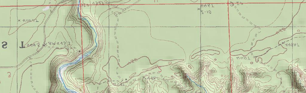
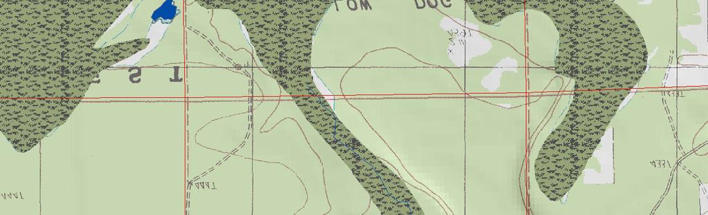
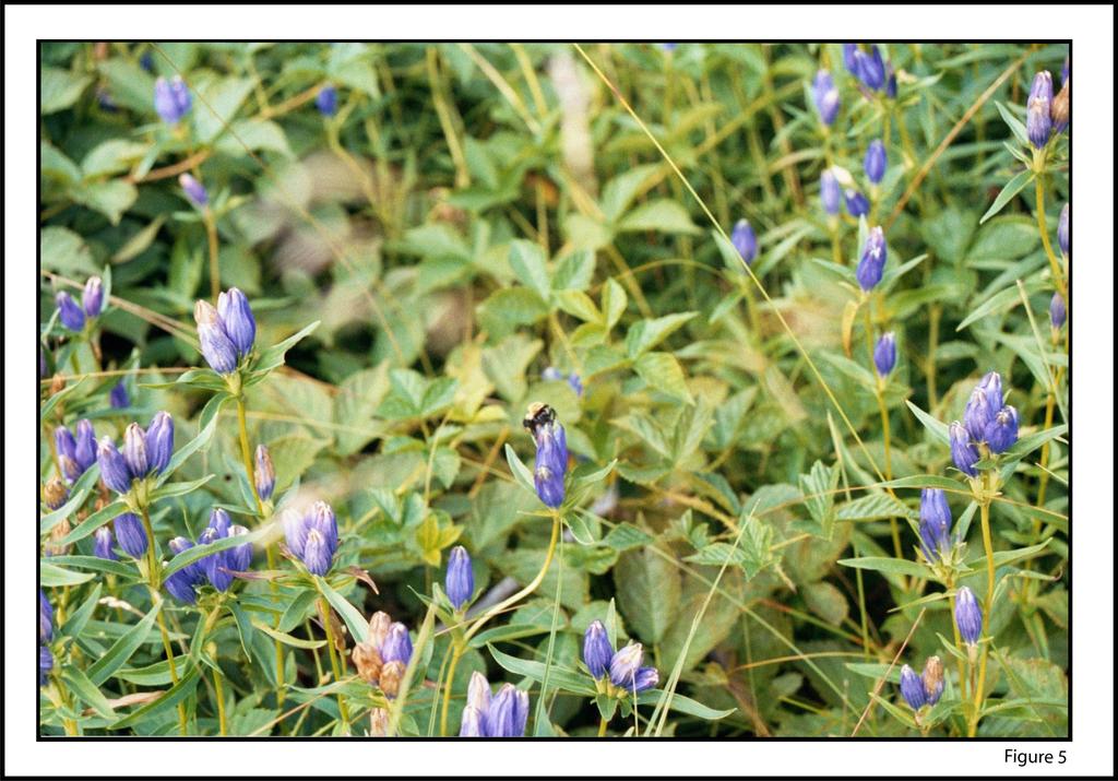
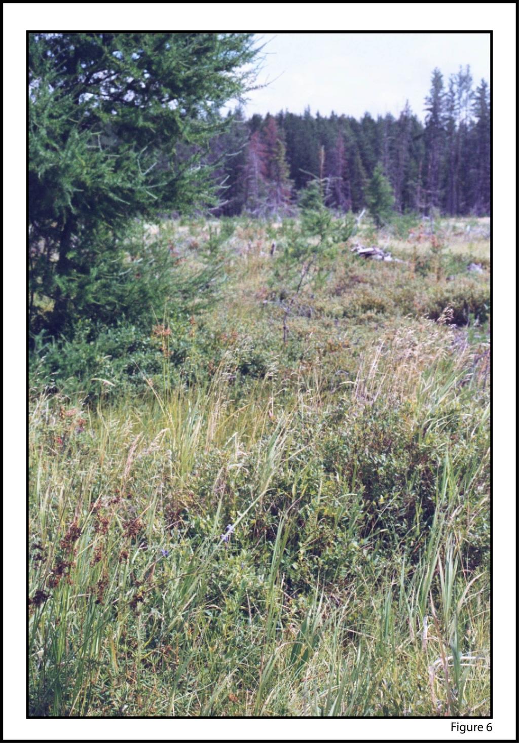
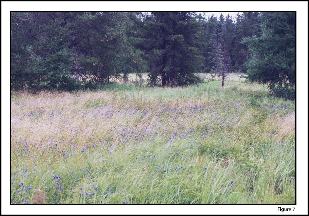
2 Narrow-leaved Gentian 1. Introduction Several Narrow-leaved Gentian NLG) plants were found along the Salmon Trout River in the vicinity of the Eagle Project during the T & E baseline investigation in The purpose of this study in 2005 was to determine the approximate distribution and populations of NLG in the general project area and adjacent areas of northern Marquette County. NLG is listed as a facultative wetland species in the State of Michigan, meaning that it can survive in wetland or upland conditions. In this investigation NLG plants were found in very wet conditions along streams and also in dry conditions on the upper fringe of wetlands. The Michigan Natural Features Inventory MNFI) considers the NLG a species of threatened status. 2. Study Area The study area included the fringe areas along the Yellow Dog River, the Main Branch Salmon Trout River, and several streams to the west of the Eagle Project area to the Peshekee River Figures 1 and 3). Also included in the investigation area were Harvey Lake and Powell Lake located on the Sands Plain, south of the City of Marquette approximately miles south of the Eagle Project site). 3. Results of Investigation Flowering NLG plants Figure 2, 5, 6 and 7) were found in all areas investigated along the Yellow Dog River. This included areas from 0.4 miles downstream to 0.6 miles upstream of the Trail 5 bridge on the left north) side of the river Figure 2). The first flowering plant was observed on July 9, The NLG continued to bloom through September These plants were observed in very wet areas in heavy organic soil along the Yellow Dog River and in the drier fringe areas in sandy soils several hundred feet from the river Sections 13 and 14, T50N-R29W) Figure 2). Additional flowering plants were observed in Section 24, T50N-R29W, south of the Yellow Dog River at the edge of the wetland near the bedrock outcrop. Several thousand flowering plants were observed in the Yellow Dog River areas. NLG were found along the Salmon Trout River in approximately the same areas where they were recorded by Wetland Coastal Resources in 2004 Figure 4). This area included the right side north and east) of the Salmon Trout River from upstream of the ore body to a point just upstream south) of County Road AAA Triple A Road) in Section 11, T50N-R29W. Several hundred flowering plants were observed in August and September The investigation continued west of the Eagle Project area along the Triple A Road to the West Branch Huron River Road and then on to the Peshekee Grade. These roads
3 traverse western Marquette County, eastern Baraga County and then back into Marquette County Figures 3). Flowering NLG were observed at nearly all stream crossings along the road rights-of-way. They were observed in small borrow pits near the roads, sometimes in very dry perched areas in sand and gravel soils. At most locations at least fifty flowering plants were observed and sometimes several hundred plants were observed at single locations. Approximately fifty NLG were also observed south of Lake Arfelin in Sections 21 and 22, T49N-RW Figure 3). The habitat in this location was a relatively dry bog adjacent to a small stream. NLG several hundred) were observed along the southern shore of Harvey Lake Section 31, T47N-R25W) in dry sandy soils. NLG could not be found during this study period in the gravelly soils on the shore of Powell Lake in Sections 8 and 9, T46N-R25W.
4 NARROW LEAVED GENTIAN LOCATIONS-REGIONAL VIEW Northwestern Road Legend Ford Narrow Leaved Gentian Road/Trail Hydrography Wetland County Boundary ^_ Eagle Project Site Baraga County Triple A Road Figure 2 Map Area ^_ Figure 3 Map Area Ford Map Area Pesheekee Grade Marquette County Reference Hydrography, Wetland, and Road data from Michigan Center for Geographic Information. Plant locations collected with GPS, Kennecott Minerals Co. F Miles N o r t h J a c k s o n C o m p a n y ENVIRONMENTAL SCIENCE & ENGINEERING FIGURE 1
5 NARROW LEAVED GENTIAN LOCATIONS - EAST ad North western Ro T51N R28W Legend Narrow Leaved Gentian Road/Trail Hydrography Wetland Triple A Road County Boundary Town & Range Line Tro ut T51N R29W Ri ve r 33 Section Line on lm Sa _ ^ _ ^ 12 Eagle Project Site Triple A Road Baraga County Yello w r Riv e 13 Dog T50N R29W il 5 Tra T50N R28W Marquette County T49N R29W Map Area Reference Hydrography, Wetland, and Road data from Michigan Center for Geographic Information. Plant locations collected with GPS, Kennecott Minerals Co. 31 T49N R28W 0 F Miles No r t h J ac k s o n Co mpa ny ENVIRONMENTAL SCIENCE & ENGINEERING FIGURE 2
6 NARROW LEAVED GENTIAN LOCATIONS - WEST Riv er Legend T50N R31W T50N RW 21 Litt le 29 e d a Gr ee ek Pe s Hydrography Wetland County Boundary Town & Range Line st We 28 Section Line T50N R29W h ch Bran Narrow Leaved Gentian Road/Trail Hu ro n 10 Baraga County Pe shekee Grade Peshe kee T49N R31W Marquette County er Riv Map Area T49N RW T49N R29W Reference Hydrography, Wetland, and Road data from Michigan Center for Geographic Information. Plant locations collected with GPS, Kennecott Minerals Co F Miles No r t h J ac k s o n Co mpa ny ENVIRONMENTAL SCIENCE & ENGINEERING FIGURE 3

7
8
9
10
Boatswain bay biodiversity reserve
 Boatswain bay biodiversity reserve March 2003 1 1. Plan and description 1.1. Geographic location, boundaries and dimensions The plan of the proposed Boatswain bay biodiversity reserve and its location
TRAILS WHERE TO FIND TRAILS IN NOVA SCOTIA
 TRAILs SIGNAGE Know the Signs............................ 44 WHERE YOU CAN RIDE Roads and Highways........................ 46 Designated Trails........................... 47 Established Trails...........................
Description of the Proposed Action for the Big Creek / Yellow Pine Travel Plan (Snow-free Season) and Big Creek Ford Project
 and Big Creek Ford Project") Description of the Proposed Action for the Big Creek / Yellow Pine Travel Plan (Snow-free Season) and Big Creek Ford Project Payette National Forest Krassel Ranger District Valley and Idaho Counties, Idaho
Description of the Proposed Action for the Big Creek / Yellow Pine Travel Plan (Snow-free Season) and Big Creek Ford Project Payette National Forest Krassel Ranger District Valley and Idaho Counties, Idaho
There are actually six geographic sub-regions, three in both the uplands and the lowlands.
 6 Regions of AR Although Arkansas is most easily divided into two distinct geographical regions, the northwestern uplands and the southeastern lowlands, this description does not accurately portray the
Hydraulic Report. Trail 5 Snowmobile Trail Over Mulligan Creek. Prepared By: COLEMAN ENGINEERING COMPANY Karisa V. Falls, P.E.
 Prepared for: Prepared by: Marquette County Road Commission Coleman Engineering Company Marquette, Michigan Iron Mountain, MI December 2011 Hydraulic Report Trail 5 Snowmobile Trail Over Mulligan Creek
2.1 Physical and Biological Description Matabitchuan River Watershed
 2.1 Physical and Biological Description Watershed 2.1.1 Physical Description The system watershed has a total area of about 933 km 2 and is a tributary system to Lake Temiskaming and the Ottawa River Drainage
Site Location. Site Location. Renville. Renville County. County. Sacred Heart Township. Chippewa. Kandiyohi. Yellow Medicine.
 M I N N E S O T A T117N Chippewa T117N R37 Sec 15 T117N Kandiyohi Sec 16 Site Location Sec 14 T114N R37 W ) 61 Sec 13 T116N R37W 565 12 Sec 22 Sec 23 Sec 24 565 10 565 11 Sec 21 )58 Sec 28 565 19 T114N
Mark West Creek Flow Study Report
 Mark West Creek Flow Study Report Biology and Geology of Mark West Creek The headwaters of Mark West Creek are located in the Mayacamas Mountain range, which border Napa and Sonoma County, where it then
Finn Creek Park. Management Direction Statement Amendment
 Finn Creek Park Management Direction Statement Amendment November 2013 Management Direction Statement Amendment Approved by: Jeff Leahy Regional Director, Thompson Cariboo BC Parks November 12, 2013 Date
KP Lasnaya 1 River
 KP 370.2 Lasnaya 1 River The Lasnaya 1 River crossing is protected by Reno mattings and a gabion wall on the north bank (Photo 1). The south bank consists of natural river gravel deposits on top of Reno
Photographing Upper Peninsula Waterfalls
 Photographing Upper Peninsula Waterfalls Tod Poirier Freelance Photographer Photography is one of my passions. The following spread showcases several Upper Peninsula waterfalls. At times a single drop
UAV Flight Services Company. What We Do. What Sets us Apart
 UAV Flight Services Company A dedicated team of aviators, technologists, and engineers. What We Do UAV flight services for data collection, mapping, and inspection What Sets us Apart Extensive field experience,
2015 Brain Wrinkles. SS8G1b
 SS8G1b Georgia is a geographically diverse state that is divided into five regions. The first three regions (Appalachian Plateau, Valley and Ridge, and Blue Ridge) are in the mountains and foothills of
Camping (Primitive) Camping (RV) Electrical Potable Water Grill Established Fire Pit Picnic Table
 Camping (RV) Electrical Potable Water Grill Established Fire Pit Picnic Table") Alden - 9th Road River Mile 777 Map: 38.20833, -98.32031 Managing Agency: Kansas Department of Wildlife, Parks & Tourism Nearest Community: Alden, Rice County Kansas Developed Amenities Provided Parking
Alden - 9th Road River Mile 777 Map: 38.20833, -98.32031 Managing Agency: Kansas Department of Wildlife, Parks & Tourism Nearest Community: Alden, Rice County Kansas Developed Amenities Provided Parking
CRAZY HORSE TRAIL GUIDE
 CRAZY HORSE TRAIL GUIDE Abridged Version: July 2016 This is a short form of our interpretive trail guide for the Crazy Horse Trail. The full version of the guide has a more detailed description of the
Pinellas County Environmental Lands
 Pinellas County Environmental Lands In addition to traditional parks and recreation facilities, Pinellas County owns and manages a system of environmental lands that provides specialized resource-based
X. WHATCOM CREEK SMA. X.1 Watershed Analysis. X.1.1 Landscape Setting
 X. WHATCOM CREEK SMA Summary: The entire length of Whatcom Creek is located within the City of Bellingham. SMA jurisdiction associated with this creek is approximately 300 acres. Land use is dominated
Jan Lake Representative Area -- Concept Management Plan --
 Jan Lake Representative Area -- Concept Management Plan -- Saskatchewan Environment and Resource Management December, 1999 Saskatchewan s Representative Areas Network Program The government of Saskatchewan,
19 Meetinghouse Road, Athens, VT
 19 Meetinghouse Road, Athens, VT Curtis Trousdale, Owner, Broker, Realtor Cell: 802-233-5589 curtis@preferredpropertiesvt.com 2004 Williston Road, South Burlington VT 05403 www.preferredpropertiesvt.com
VOLUME II APPENDIX F DETAILED PHYSICAL DESCRIPTION OF PROJECT RESERVOIRS AND LANDS
 VOLUME II APPENDIX F DETAILED PHYSICAL DESCRIPTION OF PROJECT RESERVOIRS AND LANDS THE CENTRAL NEBRASKA PUBLIC POWER AND IRRIGATION DISTRICT FERC PROJECT NO. 1417 PHYSICAL DESCRIPTION OF PROJECT LANDS
Did It. naturalists. Young. Moving and melting ice shaped many of Minnesota s land features. 30 Minnesota Conservation Volunteer
 Young naturalists by Mary Hoff Photography by Gary Alan Nelson T he Glacier Did It Moving and melting ice shaped many of Minnesota s land features. Shut your eyes. Imagine that it s a sunny summer day
Final Drainage Letter Pikes Peak Community College Downtown Parking Lot Colorado Springs, Colorado
 Final Drainage Letter Pikes Peak Community College Downtown Parking Lot Colorado Springs, Colorado Prepared for: Pikes Peak Community College 5775 South Academy Boulevard Colorado Springs, CO 80906-5422
STORNETTA BROTHERS COASTAL RANCH
 STORNETTA BROTHERS COASTAL RANCH Location: Surrounding Point Arena Lighthouse and immediately south of Manchester State Park Mendocino Co., CA Acres: 1,860 Resources: Over two miles of Pacific Ocean coastline
Access: The rocky shoreline is only accessible via private property.
 10. Whale Cove Site description: Whale Cove is a small cove fringed by private homes and condominiums with diverse and relatively undisturbed rocky intertidal and subtidal habitat located approximately
Priority Species, Communities, Ecosystems, and Threats
 Priority Species, Communities, Ecosystems, and Threats East Gippsland Regional Catchment Strategy 2015/2016 1.0 Objective This document aims to assist in the preparation of project applications for 2015-2016
Whitemouth Falls Provincial Park. Draft Management Plan
 Whitemouth Falls Provincial Park Draft Management Plan Whitemouth Falls Provincial Park Draft Management Plan Table of Contents 1. Introduction... 3 2. Park History... 3 3. Park Attributes... 4 3.1 Natural...
MAIN LAKE PROVINCIAL PARK
 MAIN LAKE PROVINCIAL PARK PURPOSE STATEMENT AND ZONING PLAN March 2003 MAIN LAKE PROVINCIAL PARK Purpose Statement and Zoning Plan Primary Role The primary role of Main Lake Park is to protect a biologically
New England National Scenic Trail. Land and Water Conservation Fund FY2014 Request
 New England National Scenic Trail Land and Water Conservation Fund FY2014 Request National Trails System Land and Water Conservation Fund FY2014 New England National Scenic Trail Tanager Hill Penwood State
Carson City Open Space APNs and , west of Deer Run Road bridge
 32 acres (See separate packet for information on this open space property) OPEN SPACE PROPERTY APNs 008-541-73 and 008-541-92 (north and south sides of the river) Morgan Mill Road River Access Area (parking
A G E N D A MEETING CITY COUNCIL THIRD FLOOR ANNEX CHAMBERS. TUESDAY, September 27, :45 PM
 A G E N D A MEETING CITY COUNCIL THIRD FLOOR ANNEX CHAMBERS TUESDAY, Septeber 27, 2016 5:45 PM Pledge of Allegiance Moent of Silence Roll Call Minutes Mayor s Report/City Council Sub-Coittee Reports City
Education Programs Candle Lake Provincial Park
 Education Programs Candle Lake Provincial Park 2018 Programs Bring your class to our outdoor classroom! Guided school programs are offered spring and fall in Candle Lake Provincial Park. Booking: Accepted
Notes. Section 1. Northville to Benson Trail follows Main Street S and Bridge Street W
 Mile Section Mile NPT Mileage Table Notes Section 1. Northville to Benson 0.00 0.00 Trail begins at arch on South Main Street in Northville. Register located in parking lot in rear. 0.03 0.03 Trail follows
SIMON CANYON AREA OF CRITICAL ENVIRONMENTAL CONCERN (ACEC)
") SIMON CANYON AREA OF CRITICAL ENVIRONMENTAL CONCERN (ACEC) Activities: Facilities: Season / Hours: Description: Hiking, backpacking, fishing, picnicking, watchable wildlife. A graveled parking area, picnic
SIMON CANYON AREA OF CRITICAL ENVIRONMENTAL CONCERN (ACEC) Activities: Facilities: Season / Hours: Description: Hiking, backpacking, fishing, picnicking, watchable wildlife. A graveled parking area, picnic
General Highway System SHEET 1 HILTON HEAD ISLAND URBAN AREA
 5 6 7 8 A A B B General Highway System SHEET 1 HILTON HEAD ISLAND URBAN AREA SECONDARY ROUTE - - - - - 9 WETLAND OR MARSH - - - - - - - - - CHURCH AND CEMETERY - - - - - - - - CEMETERY - - - - - LM 78
COMMUNITY MEETING NOVEMBER 1, Wheaton Regional Park Pine Lake Trail
 COMMUNITY MEETING NOVEMBER 1, 2012 MEETING AGENDA I. Introduction of Project Team II. Trail Renovation Process III. Wheaton Regional Park IV. Pine Lake Trail Renovation Project V. Comments and Questions
Bear Creek Habitat Improvement Project
 06/10/10 Bear Creek Habitat Improvement Project El Paso County, Colorado Pike National Forest and Colorado Springs Utilities Owned Land Report prepared by: Eric Billmeyer Executive Director Rocky Mountain
Two Lots with Drilled Well Savary Island, BC
 Two Lots with Drilled Well Savary Island, BC Jason Zroback jason@landquest.com 1 (604) 414-5577 Jamie Zroback jamie@landquest.com 1 (604) 483-1605 Marketing British Columbia to the World The Source for
Appendix I. Wilderness Review
 Appendix I. Wilderness Review This appendix contains the wilderness inventory conducted for the Ash Meadows, Moapa Valley, and Pahranagat National Wildlife Refuges (NWRs) as part of the Comprehensive Conservation
CH. 1 Europe and Russia: Physical Geography. Section 1 Land and Water p Europe and Russia are part of the world s largest landmass called.
 CH. 1 Europe and Russia: Physical Geography Section 1 Land and Water p.10-16 Europe and Russia are part of the world s largest landmass called. The country of Russia stretches over both continents. About
Two Lots with Fixer-Upper Cabin & Drilled Well
 Two Lots with Fixer-Upper Cabin & Drilled Well Jason Zroback jason@landquest.com 1 (604) 414-5577 Jamie Zroback jamie@landquest.com 1 (604) 483-1605 Marketing British Columbia to the World The Source for
Directions to Soil Judging Practice Pits. Lost call Jim Turenne cell , pit location are posted at:
 Directions to Soil Judging Practice Pits. Lost call Jim Turenne cell 401-255-6206, pit location are posted at: http://maps.google.com/maps/ms?hl=en&ie=utf8&msa=0&ll=41.508577,- 71.523743&spn=0.447349,0.829468&z=10&msid=113798583893585652288.0
print materials visit information on free live seminars, online courses, and
 The AOPA Air Safety Foundation is dedicated to making flying easier and safer for general aviation pilots. For information on free live seminars, online courses, and print materials visit. ILS Critical
Version Isolated & Non-Waters Only 1 of 3
 APPROVED JURISDICTIONAL DETERMINATION FORM U.S. Army Corps of Engineers SECTION I: BACKGROUND INFORMATION A. REPORT COMPLETION DATE FOR APPROVED JURISDICTIONAL DETERMINATION (JD): July 6, 2010. B. DISTRICT
2.0 PARK VISION AND ROLES
 2.0 PARK VISION AND ROLES 2.1 Significance in the Protected Area System Marble Range and Edge Hills provincial parks protect 6.8% of the Pavillion Ranges Ecosection, which is located in the Southern Interior
Manitowoc County. Ice Age Trail. Manitowoc. 322 Ice Age Trail Guidebook Two Rivers. Ice Age Trail Alliance
 KEWAUNEE Ice Age Trail Manitowoc County Ice Age Trail Alliance wwwiceagetrailorg 10 Tisch Mills Mishicot Two Creeks Buried Forest State Forest 10 310 Manitowoc Two Rivers gan Manitowoc County 43 147 Tisch
3rd GRADE MINIMUM CONTENTS UDI 1: LANDSCAPES (5)
") 3rd GRADE MINIMUM CONTENTS UDI 1: LANDSCAPES (5) DIFFERENT LANDSCAPES A landscape is all the things that we see in a place. There are different types of landscapes. Mountain landscapes have mountains and
3rd GRADE MINIMUM CONTENTS UDI 1: LANDSCAPES (5) DIFFERENT LANDSCAPES A landscape is all the things that we see in a place. There are different types of landscapes. Mountain landscapes have mountains and
MARBLE RIVER PROVINCIAL PARK
 MARBLE RIVER PROVINCIAL PARK PURPOSE STATEMENT AND ZONING PLAN March 2003 MARBLE RIVER PROVINCIAL PARK Purpose Statement and Zoning Plan Primary Role The primary role of Marble River Park is to protect
SS8G1 The student will describe Georgia with regard to physical features and location.
 SS8G1ab Standards SS8G1 The student will describe Georgia with regard to physical features and location. a. Locate Georgia in relation to the region, nation, continent, and hemispheres. b. Describe the
3.0 THE NORTH SASKATCHEWAN IN ALBERTA
 3.0 THE NORTH SASKATCHEWAN IN ALBERTA 3.1 WATERSHED OVERVIEW Wherever you are on earth, you are in a watershed. Most of the rain and snow falling outside your window will eventually find its way to a local
Education Programs Duck Mountain Provincial Park
 Education Programs Duck Mountain Provincial Park 2018 Programs Bring your class to our outdoor classroom! Guided school programs are offered during the spring in Duck Mountain Provincial Park. Booking:
What Is An Ecoregion?
 Ecoregions of Texas What Is An Ecoregion? Ecoregion a major ecosystem with distinctive geography, characteristic plants and animals, and ecosystems that receives uniform solar radiation and moisture Sometimes
West Shore Sail Club 2016 CRUISING AWARDS
 REGISTRATION To qualify for 2016 Cruising Awards, the completed registration form shall have been submitted to the Cruising Log Master by June 10 th along with a $30.00 non-refundable check made payable
A Publication of Friends of Sleeping Bear Dunes
 A Publication of Friends of Sleeping Bear Dunes 2014, Friends of Sleeping Bear Dunes, P.O. Box 545, Empire, MI 49630 www.friendsofsleepingbear.org info@friendsofsleepingbear.org Learn more about the Friends
Quintessential Rare Plant Site Protected, Forever Celebrating the New Wilsons Lake Conservation Lands
 Quintessential Rare Plant Site Protected, Forever Celebrating the New Wilsons Lake Conservation Lands A hotspot for Canadian endangered species conservation has been protected, forever, in Nova Scotia.
Hiawatha National Forest St. Ignace Ranger District. File Code: 1950 Date: August 5, 2011
 United States Department of Agriculture Forest Service Hiawatha National Forest St. Ignace Ranger District W1900 West US-2 St. Ignace, MI 49781 906-643-7900 File Code: 1950 Date: August 5, 2011 Dear National
Region 1 Piney Woods
 Region 1 Piney Woods Piney Woods 1. This ecoregion is found in East Texas. 2. Climate: average annual rainfall of 36 to 50 inches is fairly uniformly distributed throughout the year, and humidity and temperatures
ANCLOTE COASTAL TRAIL ALTERNATIVES ANALYSIS STUDY
 ANCLOTE COASTAL TRAIL ALTERNATIVES ANALYSIS STUDY PASCO COUNTY MPO JULY 2015 PROJECT OVERVIEW... INTRODUCTION EXECUTIVE SUMMARY CONTEXT... TAMPA BAY AREA, PINELLAS, & PASCO COUNTY S MULTI-USE TRAIL PLANS
STRATHCONA COUNTY YELLOWHEAD NORTH ARTERIAL ROAD FUNCTIONAL DESIGN STUDY
 STRATHCONA COUNTY Appendix G - Right-of-Way Plans ( TR) TC +65.7 POB +. YELLOW HEAD NORTH 376 MC PIPELINE CORRIDOR.56 HECTARES.7 HECTARES. HECTARES.3 HECTARES LOT B A. TOWNSHIP ROAD 53 JOB RANGE ROAD 3
2.0 Physical Characteristics
 _ 2.0 Physical Characteristics 2.1 Existing Land Use for the Project The site is comprised of approximately 114 acres bounded by Highway 101 to the north, the existing town of Los Alamos to the east, State
Buffalo Pound Provincial Park
 Pound Park Pound Park Pound Park Pound Park 2019 2019 Bring your class to our outdoor 2019 school programs are Bring yourguided class to our outdoor offered in theto spring at Pound are Guided school programs
ROBERTS CREEK PROVINCIAL PARK MASTER PLAN. November, 1981
 Ministry of Lands, Parks and Housing Parks and Outdoor Recreation Division Park Operations Branch North Vancouver, B. C. ROBERTS CREEK PROVINCIAL PARK MASTER PLAN November, 1981 Mr. G. Trachuk Director
CELEBRATE WEST GREENWICH GEOCACHING THROUGHOUT WEST GREENWICH
 CELEBRATE WEST GREENWICH GEOCACHING THROUGHOUT WEST GREENWICH The West Greenwich Land Trust (WGLT) is sponsoring Celebrate West Greenwich, an event designed to celebrate the beauty and history of scenic
MANAGEMENT DIRECTION STATEMENT
 Skeena District MAAGEMET DIRECTIO STATEMET July, 2000 for Driftwood Canyon Provincial Park Ministry of Environment Lands and Parks BC Parks Division i Table of Contents Driftwood Canyon Park Approvals
Mills Pecos River Ranch 7800 Acres Val Verde County, Texas Situated along both sides of the Pecos River
 Mills Pecos River Ranch 7800 Acres Val Verde County, Texas Situated along both sides of the Pecos River James King, Agent Office 432-426-2024 Cell 432-386-2821 James@KingLandWater.com King Land & Water
CARMANAH WALBRAN PROVINCIAL PARK
 CARMANAH WALBRAN PROVINCIAL PARK PURPOSE STATEMENT AND ZONING PLAN September 2003 1 CARMANAH WALBRAN PROVINCIAL PARK Purpose Statement and Zoning Plan Carmanah Walbran Provincial Park is an expansion of
Land Protection Accomplishments
 2017 Land Protection Accomplishments Conserving Open Space and Recreational Access On the Pacific Crest National Scenic Trail View from the Pacific Crest Trail of Donomore Meadows near the California/Oregon
2015 Brain Wrinkles. SS8G1b
 SS8G1b Standards SS8G1 The student will describe Georgia with regard to physical features and location. b. Describe the five geographic regions of Georgia; include the Blue Ridge Mountains, Valley and
OUR COUNTRY INDIA L OCATIONAL SETTING
 7 India is a country of vast geographical expanse. In the north, it is bound by the lofty Himalayas. The Arabian Sea in the west, the Bay of Bengal in the east and the Indian Ocean in the south, wash the
Conservation Results In An Urban Environment Through Public-Private Partnerships
 Conservation Results In An Urban Environment Through Public-Private Partnerships James Boase, U.S. Fish and Wildlife Service Supporting Contributors John Hartig, USFWS Allison Krueger, USFWS Ed Roseman,
Bradley Brook Relocation Project. Scoping Notice. Saco Ranger District. United States Department of Agriculture Forest Service
 Bradley Brook Relocation Project United States Department of Agriculture Forest Service Scoping Notice White Mountain National Forest February 2011 For Information Contact: Jenny Burnett White Mountain
Cataloochee. Fishing Species Rainbow Trout and Brook Trout. Recreation
 Cataloochee River Information The Cataloochee River is located in the historic Cataloochee Valley--a relatively remote part of Smoky Mountain National Park. The campground is a secluded setting and offers
Table 1: Black Eagle Communication Site. Latitude 1 Longitude 1 Elev 2 Address T/R/S 3 APN 4 USGS Quadrangle
 County of Riverside Public Safety Enterprise Communication Project Appendix A: Candidate Site Descriptions Overview The site is located on a previously graded and benched plateau within the Black Eagle
Wallace Falls State Park Classification and Management Planning Stage 3 Preliminary Recommendations July 18, 2018 Sultan City Hall
 Wallace Falls State Park Classification and Management Planning Stage 3 Preliminary Recommendations July 18, 2018 Sultan City Hall Thanks for coming! This document contains State Parks preliminary recommendations
Mackinnon Esker Ecological Reserve Draft - Management Plan
 Mackinnon Esker Ecological Reserve Draft - Management Plan May 2011 Photo Credit: This document replaces the direction provided in the Carp Lake Provincial Park and Protected Area and Mackinnon Esker Ecological
Sasagiu Rapids Provincial Park. Draft Management Plan
 Sasagiu Rapids Provincial Park Draft Management Plan 2 Sasagiu Rapids Provincial Park Table of Contents 1. Introduction... 3 2. Background and Park Attributes... 3 2.1 Park History.... 3 2.2 Natural Features...
Summary of prescribed fires in Prince Albert National Park 2015
 Summary of prescribed fires in Prince Albert National Park 2015 Prince Albert National Park conducted four controlled fires in spring 2015, plus an additional fire in October. Fuel Management for Hazard
OMINEACA PROVINCIAL PARK
 OMINEACA PROVINCIAL PARK AND PROTECTED AREA PURPOSE STATEMENT AND ZONING PLAN March 2003 OMINECA PROVINCIAL PARK AND PROTECTED AREA Purpose Statement and Zoning Plan Omineca Park and Omineca Protected
REMARKS: All depths are in reference to Mean Low Water (MLW). Channel Length is in nautical miles.
. Channel Length is in nautical miles.") TO: The Record RIVER/HARBOR NAME AND STATE: Shrewsbury River, New Jersey REPORT OF CHANNEL CONDITIONS 100 TO 400 FEET WIDE (ER 1130-2-3165) PAGE: 1 OF 1 DATE: 23 January 2012 FROM: U.S. Army Corps of Engineers
TO: The Record RIVER/HARBOR NAME AND STATE: Shrewsbury River, New Jersey REPORT OF CHANNEL CONDITIONS 100 TO 400 FEET WIDE (ER 1130-2-3165) PAGE: 1 OF 1 DATE: 23 January 2012 FROM: U.S. Army Corps of Engineers
 RUSSIA OR CA WA AK NV CANADA ID UT AZ MT WY CO NM MEXICO HI ND SD NE KS TX MN OK CANADA IA WI LA IL MI IN OH WV VA FL ME VT NH MA NY CT NJ PA MO KY NC TN SC AR AL GA MS MD BAHAMAS CUBA RI DE 3 RUSSIA 1
ACCESS INVENTORY AND IMPROVEMENT PLAN
 ACCESS INVENTOR AND IMPROVEMENT PLAN Prepared by: Western Upper Peninsula Planning & Development Region Financial Assistance for the project was provided, in part, by the Michigan Coastal Management Program,
Level IV Ecoregions of the Northeast Glacial Lakes Watershed Project Area
 Level IV Ecoregions of the Northeast Glacial Lakes Watershed Project Area Ecoregions are areas having similar ecosystems and environmental resources including geology, physiography, vegetation, climate,
Observing Subtleties: Traditional Knowledge and Optimal Water Management of Lake St. Martin
 Observing Subtleties: Traditional Knowledge and Optimal Water Management of Lake St. Martin Myrle Traverse and Richard Baydack Abstract Lake St. Martin First Nation is an Anishinaabe community situated
PROPOSED QUARRY FOOTPRINT PHASE 2 PHASE 3. PHASE 5 West. PHASE 5 East. PHASE 6 West. PHASE 6 East PHASE 7 PHASE 4 PHASE 1
 PHASE 4 \\Cd1220-f02\01609\active\2001 Active Projects\1100-1199\G1188\graphics\GIS\MXD\_Final Draft Sept 2008\MXD\Section_5\62601188_Fig5-0_ProposedQuarryFootprint_01Dec08_NJB.mxd PHASE 7 PHASE 5 West
beach. Make the ford and follow the trail out to the junction with Red Creek Tr in an open grassy area.
 Description: This is a moderate to slightly strenuous 22.8 mile backpack (add 2.6 miles if you do the packless out and back to the Lion s Head) that will have you exploring nearly every thing that is The
TOWN OF NEW LONDON, NEW HAMPSHIRE 375 MAIN STREET NEW LONDON, NH
 TOWN OF NEW LONDON, NEW HAMPSHIRE 375 MAIN STREET NEW LONDON, NH 03257 WWW.NL-NH.COM CONSERVATION COMMISSION AUGUST 20, 2008 Present: Terry Dancy, Dale Conly, Bob Brown, Vicki Koron, Ruth White, Peter
Decision Memo Ice Age Trail Improvement (CRAC 37)
") Decision Memo Ice Age Trail Improvement (CRAC 37) U.S. Forest Service Chequamegon-Nicolet National Forest, Medford-Park Falls Ranger District Taylor County, Wisconsin T32N, R2W, Town of Grover, Section
Decision Memo Ice Age Trail Improvement (CRAC 37) U.S. Forest Service Chequamegon-Nicolet National Forest, Medford-Park Falls Ranger District Taylor County, Wisconsin T32N, R2W, Town of Grover, Section
RIM TRAIL EXTENSION PROJECT
 DECISION MEMO For RAINBOW RIM TRAIL EXTENSION PROJECT Located on National Forest System Lands USDA Forest Service, Southwest Region Kaibab National Forest - North Kaibab Ranger District T.35 N, R.1 E,
Potomac Gorge. Resource Booklet. A Natural Monument in the Shadow of National Monuments. Bridging the Watershed. Potomac Gorge 75
 Potomac Gorge Potomac Gorge A Natural Monument in the Shadow of National Monuments Resource Booklet Bridging the Watershed An outreach program of the Alice Ferguson Foundation in partnership with the National
North Shipp Ranch 4,432 +/- acres, Webb County, Texas
 North Shipp Ranch 4,432 +/- acres, Webb County, Texas North Shipp Ranch 4,432 +/- acres Webb County, Texas Harrison King, Agent Office 512.840.1175 Harrison@KingLandWater.com Location North Shipp Ranch
Diversity of Coastal Ecosystems of Maharashtra - Ecologically Sensitive Coastal Areas of Ratnagiri and Sindhudurga
 Diversity of Coastal Ecosystems of Maharashtra - Ecologically Sensitive Coastal Areas of Ratnagiri and Sindhudurga Abstract: Approximately 20% of the world s coral reefs were lost and an additional 20%
IOWA ORNITHOLOGISTS' UNION - Birding Sites in Dallas County
 IOWA ORNITHOLOGISTS' UNION - Birding Sites in Dallas County Printed on 7/19/2018 Beaver Bottoms Wetland (restricted) (Important Bird Area) GPS Coordinates:, Ownership: Private (see directions for access)
Wintergreen Woods. Phyliss Benn Trail. Owned and managed by the La Porte County Conservation Trust Inc.
 Wintergreen Woods Phyliss Benn Trail Owned and managed by the La Porte County Conservation Trust Inc. Welcome to Wintergreen Woods State Nature Preserve and the Phyliss Benn Trail As you enter the woods,
Public Notice ISSUED: December 10, 2018 EXPIRES: January 9, 2019
 APPLICANT: REFER TO: St. Louis and Lake Counties Regional Rail Authority 2018-01942-ARC Public Notice ISSUED: December 10, 2018 EXPIRES: January 9, 2019 SECTION:404 - Clean Water Act 1. APPLICATION FOR
chairs & stools-plastic V14b_Layout 1 11/07/ :05 Page 1 CHAIRS AND STOOLS - PLASTIC SHELL Primo Limited
 chairs & stools-plastic V14b_Layout 1 11/07/2018 10:05 Page 1 CHAIRS AND STOOLS - PLASTIC SHELL Primo Limited chairs & stools-plastic V14b_Layout 1 11/07/2018 10:05 Page 2 new P1918S 520mm 520mm 850mm
Sand Lakes Provincial Park. Draft Management Plan
 Sand Lakes Provincial Park Draft Management Plan 2 Sand Lakes Provincial Park Table of Contents 1. Introduction... 3 2. Background... 3 3. Park Purpose... 5 4. Park Management Guidelines... 6 Appendix...
Conservation strategy for Lumholtz s tree-kangaroo on the Atherton Tablelands.
 Conservation strategy for Lumholtz s tree-kangaroo on the Atherton Tablelands. J. Kanowski 1, J.W. Winter 2, T. Simmons 3 and N. I. J. Tucker 3 ( 1 Rainforest CRC, Environmental Studies, Griffith University,
Chichester Harbour Education Service. Chichester Harbour
 Chichester Harbour Chichester Harbour is a unique blend of land and sea, combining large open waters with narrow creeks and inlets. It is a beautiful and fascinating environment, with a wealth of learning
Warrumbungle National Park SECTION 1. Landscape
 Warrumbungle National Park SECTION 1 Landscape The Warrumbungle landscape is really strange because it is flat for ever but soon as you hit the warrumbungle reagin you go up at least 900 feet. The Warrumbungleʼs
East Branch Medway River Route 21
 East Branch River Route 2 This route is NOT recommended for NOVICE and INTERMEDIATE paddlers The route is comprised of the East Branch of the River, the River proper, and Port. Although there are a number
NORTH LAMOILLE FOREST
 NORTH LAMOILLE FOREST With long frontage on the wild and free-flowing North Branch of the Lamoille River, this recreational woodlot is a quiet spot to fish, hunt, establish an off-grid camp and enjoy distant