Composite Countywide Plan For Parks and Trails (Town of Carrboro, Town of Chapel Hill, Town of Hillsborough, City of Mebane, Orange County)
|
|
|
- Felicia Simpson
- 6 years ago
- Views:
Transcription
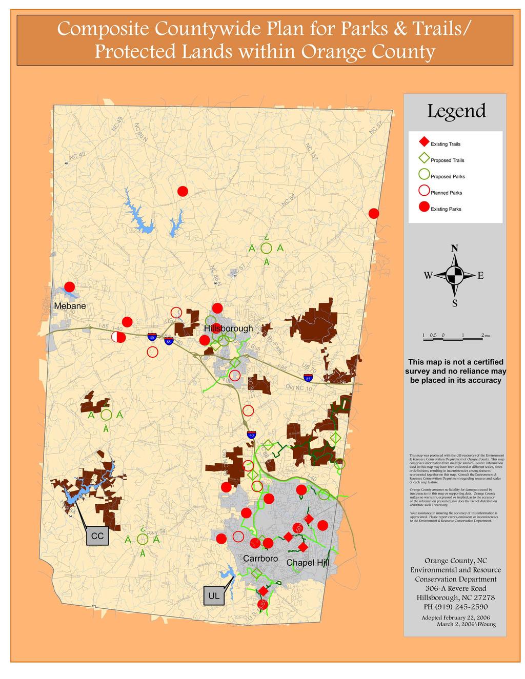
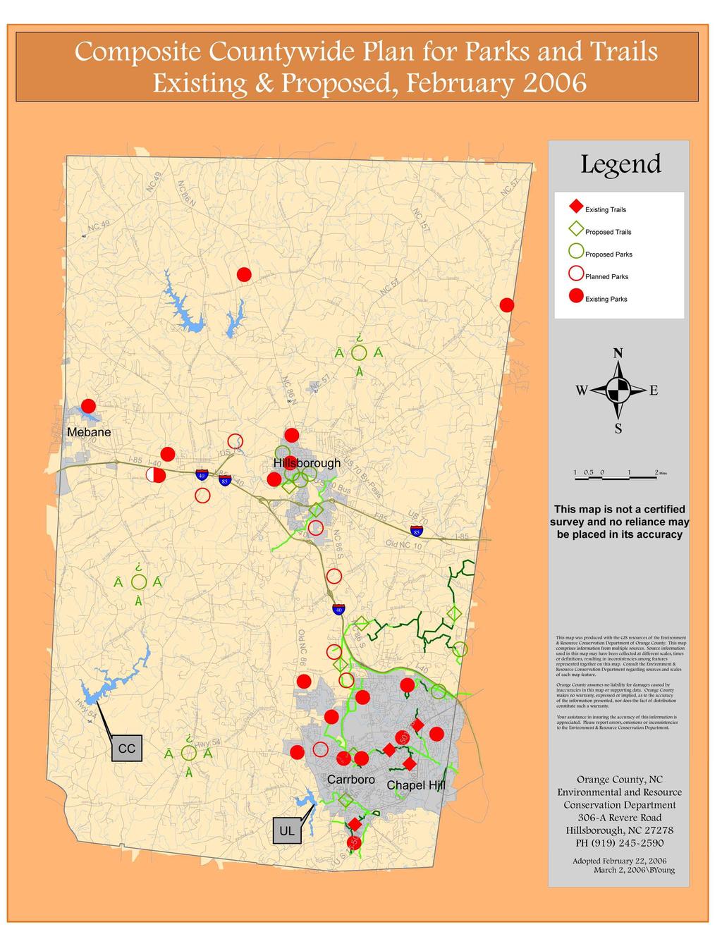
1 Adopted by IPWG 2/22/06 Composite Countywide Plan For Parks and Trails (Town of Carrboro, Town of Chapel Hill, Town of Hillsborough, City of Mebane, Orange County) Introduction / Rationale Park and open space planning for the municipal and County governments within the 400-square mile area of Orange County has been ongoing for a number of years, but the last decade has seen renewed emphasis on park services. In some ways, the existence of Duke Forest and the Eno River State Park met some of the needs for area residents for hiking and picnicking over the past years, but with the growth of population and the need for facilities for active and low-impact recreation, new parks were a service greatly desired by County and Town residents. As is the case in most states, town governments were first to venture into the provision of local parks, with Chapel Hill opening Umstead Park in the 1960's and Cedar Falls Park in the 1970's. Carrboro constructed and opened Wilson Park in Mebane constructed Lake Michael, on the Orange County side of Mebane, in 1953, and in 1981 opened a 200-acre park at the lake. Orange County came to the provision of parks somewhat later, with some facilities at Fairview constructed in the early 1980's. In 1988, Orange County adopted a Parks Plan, but it would be 11 years before Efland-Cheeks Park would open in Hillsborough does not currently have a parks system, but is on the verge of creating one with the planned opening of the RiverWalk and other parks in the next few years. The period of the late 1990's was, in many ways, a turning point for parks in the areas of park planning, land acquisition and construction. A series of reports on the coordination of park planning and the status of recreation programs and facilities led to the Joint Master Recreation and Parks Work Group report, completed in One of the recommendations of that report was the formation of an Intergovernmental Parks (IP) Work Group to serve as a vehicle for communication and collaboration between the jurisdictions. Town and County bond issues paved the way for new park construction in many of the jurisdictions. Coordination The purpose of this document and maps is to provide for the five jurisdictions a single source that can be used by policy makers, staffs and other interested groups to review all of the different parks and park plans at the same time.
2 It is envisioned that this document will enable the local governments and other park and open space partners in future decision-making to more readily identify gaps in coverage and opportunities for new parks, and to avoid the possible duplication of multiple planned parks in similar service areas. It also would be of use to the public to see the status of park planning across the five jurisdictional boundaries of the County. In 2005, as the IP Work Group was reconstituted, the need for this "umbrella" document that pulled together all of the existing park plans into one source was identified, and the elected boards from each of the jurisdictions authorized the creation of this Composite Countywide Parks Plan. In late 2005 and into 2006, the IP Work Group worked with staff to create this document. III. Status of Park Plans As noted above, each of the jurisdictions has a long history of parks and open space planning. Orange County adopted its parks plan (Recreation and Parks Element of the Comprehensive Plan) in Chapel Hill's first parks plan was adopted in 2002, Carrboro had a parks component for its northern transition area in 1989, and the Town's first adopted parks plan was approved in Although many parks plan have been on the books for years, opportunities to construct the parks have been limited, but became more numerous since approval of County and Town of Chapel Hill parks bonds in 1996, 1997, 2001 and The following table outlines the status of parks plans in each jurisdiction. Carrboro Chapel Hill Hillsborough Mebane Orange County Yes Yes NO No Yes * - Parks open and/or underway (update ) 80 acres 255 acres 28 acres 141 acres 359 acres 863 acres Update to plan underway, Northern Transition Area Plan Greenways Master Plan. Land Use Plan Vision 2010 Plan Lands Legacy Plan, Comprehensive Plan, Joint Master Recreation and Parks report
3 The Town of Carrboro is currently in the midst of updating their 1994 plan, and this update is expected to be completed later in Orange County is also planning a short-term Parks Plan Addendum in fall 2006, as an interim measure until the Parks Element of the Comprehensive Plan can be updated in full at a later date. IV. The Jurisdictional Parks Plans and Facility Summaries As noted above, each jurisdiction within Orange County has its own parks, both current and future. The following section provides a thumbnail outline of each facility, separated into current parks and planned future facilities'. A. Town of Carrboro The Town of Carrboro is currently in the midst of preparing a Parks Plan. All park facilities (unless noted) are open from 7:00am until dark, except for lighted facilities, which close at 11pm. Existing Facilities Henry Anderson III Community Park 55 acres. 302 Hwy. 54 West, 1/4 mile west of the 541 Old Fayetteville Road intersection). Baseball/softball fields (4 lighted), one multi-purpose field, basketball courts (lighted), volleyball court, tennis courts (2), horseshoe pits, fishing pond, play equipment, trail (.4mile), fenced dog park, picnic tables and grills, picnic shelter, and rest rooms. Baldwin Park 2.5 acres. 400 Broad Street. A neighborhood mini-park on Broad Street Play equipment, multi - purpose field, grill, basketball goal, and pavilion. Brewer's Lane Mini-Park 1 acre. 102 Hargraves Street, Brewer's Lane Open space and basketball court. Carrboro Elementary School Park 3 acres. 400 Shelton Street Note: weekday hours are 3pm - dark Play equipment, basketball court, picnic tables, youth baseball field, track (dirt), and open play areas. 1 This report is focused on local parks and trails and public open spaces. Other open space lands may not be incorporated into this document.
4 Century Center 7,200 square feet of public space, 100 N. Greensboro Street. Four small meeting rooms, one multi-purpose hall, handicap lift, Cybrary, and fully equipped kitchen. Simpson Street Mini-Park 1 acre. 301 Simpson Street. Picnic table, open space. New play equipment, spring Smith Soccer Field 2 acres High School Road A joint project of the Town of Carrboro, Orange County and the Chapel Hill-Carrboro Schools. Open play hours: Monday-Friday 4pm-1 0pm. This lighted field may be reserved by groups. Please call for more information. Town Commons Play Area and Pavilions 1.7 acres. 301 West Main Street at the Carrboro Town Hall Play equipment for ages 2-5 and open space play area, two large pavilions and a bandstand. Wilson Park 8.5 acres. 101 Williams Street (off North Greensboro St.) Play equipment, youth baseball field, tennis courts (4 lighted), picnic tables and grills, picnic shelter and rest rooms Planned Future Facilities Adams Tract acres. 207 Estes Drive Open Space, future trail system. Land management plan in process. Martin Luther King, Jr. Park acres Hillsborough Road. A park master plan has been developed and approved by the Board of Aldermen. B. Town of Chapel Hill Existing Facilities Burlington Park Ephesus Church Road. Facilities include: play area and picnic facilities.
5 Cedar Falls Park 66.5-acres, located on Weaver Dairy Road across from East Chapel Hill High School. Facilities include: 6 tennis courts, play area, picnic facilities, 4 softball/baseball fields, and about 1.5 miles of natural surface trails. Community Center Park 12.8-acres, located at 120 South Estes Drive. Facilities include: gymnasium, meeting room, indoor pool, climbing wall, playground, picnic facilities, outdoor basketball court, volleyball, and rose garden. The park serves as the trailhead for the 1.5 mile natural surface Battle Branch Trail and the 1.5 mile paved Bolin Creek Trail. Ephesus Park 10-acres, located on Ephesus Church Road adjacent to Ephesus School. Facilities include: 6 tennis courts and 1 softball/baseball field (shared use with School) Hargraves Park 6.8-acres, located at 216 North Roberson Street. Facilities include: softball/baseball field, gymnasium, meeting rooms, community center building, outdoor pool, playground, picnic facilities and shelter, 3 tennis courts, and outdoor basketball court. Homestead Park 40-acres, access is from the eastern end of Homestead Road. Facilities include: 2 athletic fields, 2 baseball/softball fields, playground, picnic facilities and shelter, play area, outdoor basketball court, dog park, skate park and batting cages. Jones Park 1 0-acres, located off of Purefoy Road. Facilities include: play area and picnic facilities. Lincoln Center Located at 750 South Merritt Mill Road. Facilities include: gymnasium and art studio. Meadowmont Park 68.7-acres, located on Meadowmont Lane adjacent to Rashkis School. Facilities include: gymnasium (shared use with School), 2 athletic fields, pond, and trails. Serves as a trail head for the 1 mile long paved Meadowmont Trail Open Space Acquisitions The Town owns about 726 acres of open space including the Merritt Pasture. The Town has extensive holdings along Bolin, Booker, Dry, and
6 Morgan Creeks. In addition the town has protected substantial acreage along tributaries such as Battle Branch and Tanyard Branch. Trails Battle Branch Trail 1.5 Mile natural surface trail that connects Community Center Park and the UNC campus near Forest Theater. Bolin Creek Trail 1.5 Mile paved trail that connects Martin Luther King Jr. Blvd and Community Center Park. Dry Creek Trail 1.25 Mile natural surface trail that connects East Chapel Hill High School and Erwin Road. Fan Branch Trail 1.2 Mile paved trail that connects Culbreth Road and the Southern Community Park site near Scroggs School. Lower Booker Creek Trail.85 Mile paved trail that connects Eastgate Shopping Center and Booker Creek Road. Meadowmont Trail 1 Mile paved trail that connects the west side of NC 54 with the Rashkis School site Meadowmont Nature Trails.5 Mile natural surface trail that connects Rashkis School site with Lancaster Drive Pritchard Park Nature Trail 1 Mile natural surface loop trail along the circumference of the future park site North Forest Hills Park 9.4-acres, Collum Road. Facilities include: play area, picnic facilities and shelter, and an outdoor basketball court. Oakwood Park Located on Oakwood Drive. Facilities include: 1 tennis court, play area, and picnic facilities. Umstead Park 19.5-acres, Umstead Drive. Facilities include: 1 tennis court, play area, picnic facilities and shelter, youth baseball field, outdoor basketball court, and volleyball. The park serves as a trailhead for the.4 mile natural surface Tanyard Branch Trail.
7 Westwood Park Located Westwood Street. Facilities include: play area Planned Future Facilities Dry Creek Park 32-acre site, future access anticipated from Erwin Road. To be operated by Chapel Hill Parks and Recreation Department. Most of the site anticipated to remain open space. Facilities could include: picnic facilities and shelter, play area, outdoor basketball court, dog park, trails, and other facilities approved by the Council. No funding available. No schedule for development. Homestead Park Aquatic Center 27,000 square foot building with 2 pools, locker rooms, lobby, classroom, and offices. Construction anticipated in late Future Trails Bolin Creek Trail (Extension) The Town is currently studying a possible extension of the trail from Martin Luther King Jr. Blvd to Carrboro and Seawell School Road. Dry Creek Trail (Extension) The Town is studying a possible paved extension of the trail from Perry Creek Road to Eastowne. Fan Branch Trail (Extension) The Town is currently studying a possible extension of the trail through the Southern Community Park site. Lower Booker Creek Trail (Extension) The Town anticipates the extension of the trail through the Elliott Road Shopping Center to Fordham Boulevard. Morgan Creek Trail The Town is currently in the planning process for a 1 mile long paved trail from Culbreth Road to the west side of Smith Level Road. Southern Community Park 70-acres, access is from Dogwood Acres Drive and Southern Park and Ride Lot. To be operated by Chapel Hill Parks and Recreation Department. Jointly funded by Orange County and Chapel Hill. First phase of development is anticipated to begin in 2006, opening in First phase will not be known until bid opening in early Total
8 buildout facilities to include: 3 athletic fields, 1 baseball/softball field, picnic facilities and shelter, play area, outdoor basketball courts, in line hockey court, meadow area, dog park, trails, and disk golf course.
9 Adopted by IPWG 2/22/06 C. Town of Hillsborough Existing Facilities Murray Street Park Murray Street Park is a neighborhood park, serving the West Hillsborough neighborhood. It is about one acre in size and located at the corner of Murray and Eno Streets There are various pieces of play equipment, such as swings, a chinning bar and climbing equipment. There are also benches and a wooden bridge, which crosses a small stream. Proposed Future Facilities Cates Creek Greenway / Waterstone Linear Park Cates Creek Greenway is a planned multi-use paved trail that provides an alternative connection to central Hillsborough from neighborhoods south of lnterstate 85. Cates Creek flows from the southwest to the northeast through the southern part of Hillsborough and has the potential to tie-in to an eastern extension of Riverwalk. The central part of the Cates Creek Greenway will be constructed by the Waterstone development as part of a linear park in the residential portion of the development. Continuing to the northeast, the Creek encounters both the railroad and lnterstate 85, which will be the two primary barriers. Access under lnterstate 85 is critical to the usefulness of this route for both transportation and recreational purposes. Designated open space, in a combination of ownerships, exists on both sides of lnterstate 85 and will facilitate greenway construction. Hillsborough Heights Park This is a proposed neighborhood park on Terrell Road in the Hillsborough Heights neighborhood. The Hillsborough Parks and Recreation has met with neighbors, who have asked for a neighborhood-gathering place as well as a spot for younger children to play. It will contain picnic tables, barbeque grills and a large piece of play equipment. There will also be benches and some newly planted shade trees. Riverwal k Riverwalk is a planned multi-use paved trail connecting three publicly owned properties in Hillsborough. The Feasibility Study prepared in describes a 1.6-mile trail beginning at the Orange County Courthouse and running west to town-owned Gold Park, and continuing to the State Natural Area on Occoneechee Mountain. The recommended route includes two bridges.
10 Orange County's proposed RiverPark makes a natural starting point for Riverwalk. Gold Park, a 22-acre site owned by the Town, will use Riverwalk as its primary access. The property has limited road access, but will be accessible to pedestrians with a covered walkway under the railroad trestle at the Eno River. Occoneechee State Natural Area offers visitors a look at flora and fauna more common in the mountainous parts of the state. Gold Park will contain a ball field, picnic area and other improvements. Turnip Patch Park Turnip Patch Park has been proposed as a public/private partnership between the Town of Hillsborough and Turnip Patch Park, Inc., a group of interested neighbors. It will be built on a town-owned lot bordered by West King Street, South Occoneechee Street and West Margaret Lane in the Historic District. It has been conceived as a park for 2 to 5 year olds and will contain age-appropriate play equipment. There will also be a bridge across the stream that runs through the park. Waterstone Community Park Planned 10-acre community park at the western trailhead of Cates Creek Greenway. The facility is proposed in 2 phases, with the Waterstone developer designing and constructing Phase 1 to include a soccer field and playground. The second phase will be constructed by the town using plans provided by the Waterstone developer. This will initially act as the western terminus of the Cates Creek Greenway, although further extension to the west is possible. D. Mebane (Orange County portion) Lake Michael Park Lake Michael Park is located one mile east of Mebane in Orange County on Lebanon Road. It is a 59-acre lake with two piers, with fishing. The park area has 200 acres with nature trails, picnic areas, restroom facilities, boat rental, tot play area, 3 large covered shelters and 1 small covered shelter. Expansion of the park to include a new dock and other amenities is planned.
11 E. Orange County Existing Facilities Central Recreation Center and Park Outdoor facilities at Queen and Hassell Streets in Hillsborough, include a multi-purpose field, childrens playground (5-12, ADA accessible) picnic area and parking. The recreation center includes meeting/activity rooms and a gymnasium. Efland-Cheeks Park Located just off US 70 West in Efland and Cheeks Township, the 11-acre Efland-Cheeks Park is co-located with Efland-Cheeks Elementary School and features a lighted multi-purpose field, two picnic shelters, a playground, a community center, two lighted basketball courts and nature trails (to be constructed in 2006). Fairview Park Fairview Park is located in the Fairview community in northern Hillsborough on Rainey Street. A youth baseball field, picnic area and playground currently exist, with future facilities to be constructed as part of Phase II (design underway). Little River Regional Park and Natural Area Created in conjunction with Durham County, this 391 -acre site straddles the county line in northeastern Orange County on Guess Road, and includes 7 miles of hiking trails, a playground, and two picnic shelters. An ADA loop trail, 7 miles of mountain bike trails, refurbished farm buildings, and planned horse trails. The park also protects a natural heritage corridor along the Little River. Northern Park Co-located with the Northern Human Services Center on NC 86 seven miles north of Hillsborough, Northern Park currently features a lighted baseball/softball field along with a gymnasium, playgrounds, meeting rooms, and art and pottery rooms in the Center. A master plan has been approved for the remainder of the park (see below). Open Space Acquisitions The County has acquired 502 acres of land for open space purposes, including the protection of natural areas and nature preserves and future trails, such as New Hope Preserve, Seven-Mile Creek Preserve and McGowan Creek Preserve. Skills Development Center Pocket Park Located at 503 West Franklin Street in Chapel Hill.
12 Smith Playing Fields Joint project with Carrboro, CHCCS and UNC - see listed under Carrboro above. Southern Human Services Center Nature trails at this site on Homestead Road in Chapel Hill wind around the Center and adjoining ridge. Proposed Future Facilities Adams Tract In conjunction with Carrboro - see listed under Carrboro above. Bolin Creek Trail, Phase III In conjunction with the Town of Chapel Hill - listed under Chapel Hill projects. Fairview Park, Phase II The Master Plan design is currently underway, in conjunction with the Town of Hillsborough, for the park and public campus (Public Works facilities for County and Town, other structures). Homestead Park Aquatic Center In conjunction with the Town of Chapel Hill - listed under Chapel Hill projects above. New Hope Park at Blackwood Farm 152-acres, located at New Hope Church Road and NC 86. Master plan design to begin in 2006 New Hope Preserve 31 acres to date. A preserve along New Hope Creek that will feature a trail connecting to Durham County trails, along with other low impact recreation uses, is envisioned for this area. To be created in conjunction with Durham County and City, Town of Chapel Hill and TLC. Northern Park The 48-acre site that currently houses the Northern Human Services Center and existing facilities listed above will have two additional baseball/softball fields and one multi-purpose field, along with a picnic shelter/restrooms, basketball and volleyball courts, horseshoes, a walking track and nature trails. Construction may begin in Other facilities would be built in a future phase.
13 RiverPark This six-acre open area between the Orange County Courthouse and the Eno River in downtown Hillsborough will include trails, benches and picnic tables, a performance stage, and public market (farmer's market). It is adjacent to the Stillhouse Creek Stream Restoration Project currently underway, which will feature trail connections and environmental education signage. Twin Creeks District Park (and Educational Campus) This 96-acre park along Old 86 north of Carrboro will be co-located with a 97-acre schools campus. The first phase of the park will include a picnic shelter, meadow and nature trail, and two full-size soccer fields. The full park will eventually feature four full-size soccer fields, two baseball/softball fields, tennis courts, basketball courts, a street hockey court, hiking trails, two playgrounds and a water playground, fishing, three picnic shelters, concession area, croquet and senior activities area, and use of the old farmstead buildings for activities as yet undetermined. West Ten Soccer Center Co-located with the new Gravelly Hill Middle School in western Orange County, this soccer complex will feature five full size soccer fields (including one championship field) and a practice field, along with concession area. Pending Master Plans Millhouse Road Park 69-acres adjoining Duke Forest on Millhouse Road north of Chapel Hill. Master plan design TBA. Upper Eno Preserve Public Access Areas A future nature preserve (352 acres acquired to date) located west and southwest of Hillsborough; public access areas for trails and low impact recreation are tentatively planned for two or more locations (Seven-Mile Creek, McGowan Creek).
14
15
16 Adopted by IPWG 2/22/06 VIII. Conclusion A. The purpose of this document and maps is to provide for the five jurisdictions a single source that can be used by policy makers, staffs and other interested groups to review all of the different parks and park plans at the same time. It is recommended that the governing boards of the five jurisdictions adopt the Composite Countywide Plan for Parks and Trails as a planning reference document, to be used as needed when planning for future parks and trails. B. While this document presents an important snapshot of parks and trails at this point in time, new parks and trails will be built and the information in the report will require updating. A database of park facilities was created as part of the 1999 Joint Master Recreation and Parks report, and this database is updated annually by the Orange County ERCD. It is recommended that this report should also be reviewed on a regular basis and updated every two years, to add the results of any new jurisdictional park planning and new collaborative opportunities undertaken by the respective boards. The Parks and Recreation Directors from the five jurisdictions could provide an update at the end of the calendar year (odd years, beginning in 2007) and convey this information to the County ERCD, as the keeper of the document.
Chapter eight. Parks and Recreation. Introduction. Crystal Lake Park District
 Chapter eight Parks and Recreation Introduction One of the indicators of quality of life in a city is the parks and recreation system. The City of Crystal Lake is fortunate to have an excellent parks and
Northeast Quadrant Distinctive Features
 NORTHEAST QUADRANT Northeast Quadrant Distinctive Features LAND USE The Northeast Quadrant includes all the area within the planning area that is east of Interstate 5 and to the north of State Route 44.
PIONEER PARK. City of Des Peres Parks Master Plan. SWT Design 46 INTRODUCTION
 PIONEER PARK INTRODUCTION Pioneer Park is a 7 acre neighborhood park located east of Interstate 270 and south of Manchester Road along Tallie Road. The park is situated in a residential neighborhood with
City of Keller Parks and Facilities Inventory
 City of Keller Parks and Facilities Inventory April 2013 1. BEAR CREEK PARK 44 ACRES 1 Basketball Court with 2 goals 4 Drinking Fountains 1 Large Pavilion with 4 picnic tables, electricity and fireplace
Chapter 2: Summary of Existing Open Space System
 Chapter 2: Summary of Existing Open Space System In 1976, the Wake County Board of Commissioners established the Wake County Parks and Recreation Department in order to provide park facilities and programs
Chapter 6. Action Program. Heart of the Lakes Area Recreation Plan
 Heart of the Lakes Area Recreation Plan 1. Design and construct the following trails (please see the following map): a. the Speedway Trail 1) primary pathway the main trail 2) secondary pathway the proposed
NORTHWEST SECTION CONTENTS: CLEVELAND PARK FOLWELL PARK RYAN LAKE PARK VICTORY PRAIRIE DOG PARK VICTORY PARK
 NORTHWEST SECTION CONTENTS: CLEVELAND PARK FOLWELL PARK RYAN LAKE PARK VICTORY PRAIRIE DOG PARK VICTORY PARK LUCY LANEY COMMUNITY SCHOOL N 33RD AVE N 33RD AVE SINGLE-FAMILY RESIDENTIAL MULTI-USE DIAMOND
4MRV Parks Master Plan: Site Analysis
 4MRV Parks Master Plan: Site Analysis Lardner/Klein Landscape Architects in association with: RK&K Grimm + Parker Kittelson & Associates Partners for Economic Solutions RIB U.S.Cost Civil Engineering Architecture
TRUCKEE TAHOE AIRPORT DISTRICT BOARD OF DIRECTOR STAFF REPORT
 AGENDA ITEM: 11 TRUCKEE TAHOE AIRPORT DISTRICT BOARD OF DIRECTOR STAFF REPORT AGENDA TITLE: MEETING DATE: January 24, 2018 PREPARED BY: NTPUD Agency Partnership Opportunity, Multi-Use Trailhead Access
Trail Etiquette. Hours of Operation. Trail Accessibility
 Trail Guide The Elmhurst Park District, with 28 parks and over 460 acres of land, offers nearly six miles of paved or asphalt park trails and maintains an additional 3.6 miles of trails within Elmhurst.
BASSETTS CREEK SECTION CONTENTS: BASSETTS CREEK BRYN MAWR LUCE LINE
 BASSETTS CREEK SECTION CONTENTS: BASSETTS CREEK BRYN MAWR LUCE LINE GLENWOOD AVE MULTI-USE DIAMONDS VINCENT AVE N MORGAN AVE N PENN AVE N DOG PARK MULTI-USE FIELDS PLAYGROUND AK E RD S CHESTNUT AVE DA
2. Goals and Policies. The following are the adopted Parks and Trails Goals for Stillwater Township:
 D. PARKS AND TRAILS 1. Introduction Stillwater Township s population is relatively low, with most residents living on rural residences on large lots. The need for active park space has been minimal in
NEW MEADOWS PARK PROPOSED MASTER PLAN
 NEW MEADOWS PARK PROPOSED MASTER PLAN A vision for your neighborhood park, the draft master plan is ready for your review. Tuesday September 12 th, 2017 5:30-7:00 PM Hellgate School District #4 middle
Fun Facts. How many Baseball fields do we have? a. 2 b. 14 c. 16 d. 21
 It Starts in Parks Fun Facts How many Baseball fields do we have? a. 2 b. 14 c. 16 d. 21 Fun Facts How many people visit Central Winds Park Annually? a. Over 100,000 b. 20,000 c. 10,000 d. 1,000 It Starts
Frederickson LUAC. Community Plan Update. Parks & Recreation. September 25, 2017
 Frederickson LUAC Community Plan Update Parks & Recreation September 25, 2017 Kimberly Freeman Resource Stewardship Superintendent kimberly.freeman@co.pierce.wa.us 253-798-4261 Joseph Coppo Senior Parks
Southwest Quadrant Distinctive Features
 SOUTHWEST QUADRANT Southwest Quadrant Distinctive Features LAND USE The 31.17 square mile Southwest Quadrant includes all the area within the planning area west of I-5 and south of the Sacramento River.
CITY OF FOUNTAIN INN PARKS
 CITY OF FOUNTAIN INN PARKS Country Chase Fitness Park The Country Chase Fitness Park is located in the Country Chase neighborhood at 136 Catterick Way. The park is also located adjacent to a section of
HOMER GLEN AREA COMMUNITY PARKS
 HOMER GLEN AREA COMMUNITY PARKS VILLAGE OF HOMER GLEN PARK PROPERTIES Owned and Maintained by the Village of Homer Glen Heritage Park 14110 W. 151 st Street This 103 acre park, located adjacent to Village
Lake Myra County Park. Wake County, North Carolina Community Forum #2 June 12, 2008
 Lake Myra County Park Wake County, North Carolina Community Forum #2 June 12, 2008 Welcome and Introduction Meeting Agenda Welcome Introductions of Project Team Master Plan Process Community Forum #1 Updates
J. Recreation Plan of Conservation and Development. The Town of Hebron. Section 2. Preservation of Unique Assets. 1 P a g e
 The Town of Hebron Section 2 2014 Plan of Conservation and Development Preservation of Unique Assets J. Recreation Open spaces, parks, sports fields, and recreational programs are considered essential
2014 SPLOST Final Draft County-wide Parks System Rehabilitation
 Page 1 of 5 ADA Improvements (County Wide) Accessibility projects related to trails/walkways, door entrances, pool access, curb cuts, ramps, etc. Additionally, ADA Audit of facilities to identify and prioritize
4.0 FACILITIES INVENTORY
 4.0 FACILITIES INVENTORY 4.1 PARK LEVEL OF SERVICE STANDARDS (LOS) Based on current City of Longview Parks and Recreation Level of Service (LOS) Standards (Figure G), the City currently has a deficiency
CHAPTER 5. Chapter 5 Recreation Element
 CHAPTER 5 Recreation Element Chapter 5 Recreation Element The Recreation Element of the Meyers Area Plan is a supplement to the Recreation Element of the TRPA Regional Plan and the El Dorado County General
Dover Park Master Plan. Community Design Event Tuesday, May 22, 5 7 pm
 Dover Park Master Plan Community Design Event Tuesday, May 22, 5 7 pm Agenda I. Introduction / Overview 20 minutes II. Small Group Design Activity 60 minutes III. Small Group Report Out IV. Conclusion
Municipal Park Descriptions: 1. Bear Hollow Park 4100 Bear Hollow Park Court, Murrysville, PA acres
 MUNICIPAL PARK DESCRIPTIONS Murrysville has a wide variety of parks and recreational facilities including sports fields, neighborhood parks, community parks, a Community Center, and extensive natural areas
Appendix B - Undeveloped Parks and Existing Parks with Remaining Development Programming
 Appendix B - Undeveloped Parks and Existing Parks with Remaining Development Programming Table of Contents Appendix B - Undeveloped Parks and Existing Parks with Remaining Development Programming Table
Parks, Recreation and Cultural Needs Assessment and Facilities Plan. November 21, 2016 City Council Worksession
 Parks, Recreation and Cultural Needs Assessment and Facilities Plan November 21, 2016 City Council Worksession History and Process FY16/17 Budget Appropriation for Needs Assessment, Dean and Stonewall
Appendix C - Existing Developed Parks
 Appendix C - Existing Developed Parks Table of Contents Appendix C Existing Developed Parks Table of Contents... Pg. i Introduction... Pg. ii Amos P. Catlin Park... Pg. 1 Beacon Hill Park... Pg. 1 Cambridge
Yuba Creek Natural Area Acquisition. Acme Township. Acme Township. TF Acquisition $1,576, Grand Traverse
 Yuba Creek Natural Area TF00-162 $1,576,021.00 in fee simple of 403 acres of critical wetls upl habitat with over 5,000 feet of frontage on Yuba Creek, a tributary to the east arm of Bay. 2000 Petobago
Public Park System. Township of Derry. Providing natural open space for the recreational use of our residents and guests.
 Township of Derry Public Park System Providing natural open space for the recreational use of our residents and guests. Directory of Recreational Amenities Hershey s Commitment to Recreation Famous candy
M E S T I Z O C U R T I S P A R K
 ARAPAHOE CONNECTION TO BUS ROUTE AT ND AND LAWRENCE, FUTURE LIGHT RAIL STATION LEGEND SOCIAL TRAIL FLAGSTONE PAVING TO RESTORE/MAINTAIN CONCRETE PAVING DIAGONAL CURVILINEAR SOCIAL ROUTE IS OUT OF HISTORIC
Chapel Hill Transit: Short Range Transit Plan. Preferred Alternative DRAFT
 : Short Range Transit Plan Preferred Alternative August 2018 Table of Contents Executive Summary... 1 Preferred Alternative... 3 Best Practices for Route Design... 3 Project Goals... 4 Preferred Alternative...
APPENDIX E: SUMMARY OF PUBLIC MEETING QUESTIONNAIRE RESULTS
 Appendices Gwinnett County 2004 Comprehensive Parks and Recreation Master Plan APPENDIX E: SUMMARY OF PUBLIC MEETING QUESTIONNAIRE RESULTS March 2004 Monteith Brown Planning Consultants & The Jaeger Company
City of Haslett. City of East Lansing. City of East Lansing
 Central Park North (Nancy L. Moore Park) Lake Park North Expansion White Park Expansion #2 White Park Expansion #1 County East East Haslett East East TF87-212 Acquisition $90,000.00 Park. TF08-138 Acquisition
Muncipal Park Areas - Map Locator:
 Muncipal Park Areas - Map Locator: #1 Alta Vista Park 312 Alta Vista/1707 W. Fox Located west of Alta Vista Middle School, this park consists of 15 acres and houses the American Little League with three
7. Plan Implementation
 7. Plan Implementation 7.1 Implementation Timeline This section includes a list of achievable park and recreation actions. In the Implementation Action Matrix that follows, the implementation actions have
WEST CENTRAL SECTION CONTENTS: FARWELL PARK NORTH COMMONS PARK OLIVER TRIANGLE RUSSELL PARK THEODORE WIRTH REGIONAL PARK VALLEY VIEW PARK WILLARD PARK
 WEST CENTRAL SECTION CONTENTS: FARWELL PARK NORTH COMMONS PARK OLIVER TRIANGLE RUSSELL PARK THEODORE WIRTH REGIONAL PARK VALLEY VIEW PARK WILLARD PARK FARWELL PLACE THOMAS AVE N SWING BENCH PICNIC AREA
SOAR ATHLETIC COMMITTEE
 PASCAGOULA RECREATION COMMISSION MEETING MAY 15, 2017 Mike McElhaney opened the meeting at 6:00 pm. Mike welcomed Bo Cole as a guest. A special meeting was called to review the recommendation being made
Nelson/Tasman Recreation Cross Boundary Partnerships. Presented by Richard Kempthorne Mayor Tasman District
 Nelson/Tasman Recreation Cross Boundary Partnerships Presented by Richard Kempthorne Mayor Tasman District Presentation in two parts Regional Communities Facilities Plan Regional Communities Facilities
City of Oak Harbor Parks & Descriptions
 City of Oak Harbor Parks & Descriptions North West Section Koetje Park - NE 7 th Avenue (3.5 acres) Neighborhood and Community Park with playgrounds on one tot lot, one soccer/practice field, picnic tables,
Park Design and Location Criteria
 Park Design and Location Criteria This section is presented in the interest of assisting park and recreation agencies in the development of a system of parks and recreation areas. A recreation system is
New Haven-Adams Twp Parks & Recreation Dept Citizen Survey
 New Haven-Adams Twp Parks & Recreation Dept Citizen Survey Monday, October 02, 2017 281 Total Responses Date Created: Thursday, July 13, 2017 Complete Responses: 243 Q1: Do you live in New Haven-Adams
Silver Lake Park An Environmental Jewel for the Citizens of Prince William County
 Silver Lake Park An Environmental Jewel for the Citizens of Prince William County The Prince William Park Authority Mission Statement states: The Prince William County Park Authority will create quality
We offer a wide variety of facilities including meeting rooms, two gymnasiums, parks, pavilions, multi purpose fields baseball/softball fields,
 We offer a wide variety of facilities including meeting rooms, two gymnasiums, parks, pavilions, multi purpose fields baseball/softball fields, amphitheater, pool shelters, corrals and pools, making us
MONTGOMERY TOWNSHIP OPEN SPACE & PATHWAYS COMMITTEE
 MONTGOMERY TOWNSHIP OPEN SPACE & PATHWAYS COMMITTEE Meetings: 2 nd Wednesday of each month @ 6:30 PM in the Municipal Building Questions? Call the Open Space Coordinator, Lauren Wasilauski, at (908) 359-8211
PALO CORONA REGIONAL PARK MPRPD BOARD MEETING AUGUST 8, 2018
 PALO CORONA REGIONAL PARK MPRPD BOARD MEETING AUGUST 8, 2018 ACKNOWLEDGEMENTS AGENCIES AND ORGANIZATIONS The Trust for Public Land Big Sur Land Trust Santa Lucia Conservancy California State Parks Point
and plant some trees, but that was only accomplished through state and federal work-relief programs.
 PEAVEY LOCATION AND HISTORY Peavey Park sits in the Phillips Community on a large block bounded by major streets: Franklin Avenue, Chicago Avenue, and Park Avenue. The southern continue through to Chicago
Create memories at the park!
 Create memories at the park! Reserving a shelter is not only fun, but also affordable! For more information and a complete list of locations, visit foxvalleyparkdistrict.org or call 630-897-0516. Austin
City of Chelan Shoreline Public Access Plan
 City of Shoreline Public Access Plan This City of Shoreline Public Access Plan documents how the City has planned for parks and recreation in the community, particularly along Lake and the River. This
Acquisition in fee simple of approximately one-half acre of property on the shore of Spring Lake to expand the Lakeside Beach Park.
 Lakeside Beach TF00-136 $122,550.00 in fee simple of approximately one-half acre of property on the shore of Spring Lake to exp the Lakeside Beach. 2000 River Ravines TF00-150 $910,000.00 in fee simple
Winnebago County Community Park
 Directions to Community Park From Interstate Hwy. 41 to Oshkosh exit 124, which is Hwy. 76/Jackson Street. East on Hwy 76/ Jackson Street to left on County Road Y, 1/4 mile. Winnebago County Park is on
Classes Other locations & Parks
 Other Parks 1 Classes Other locations & Parks Update: 6/11/2018 Visit us online at www.coconutcreek.net/parks-rec How to register for a class Registration is ongoing until filled, except in cases where
OAKLAND TOWNSHIP PARKS AND RECREATION MILLAGE RENEWAL AUGUST 2, 2016 BALLOT PROPOSAL QUESTIONS & ANSWERS PULL-OUT SECTION (APRIL 21, 2016)
") OAKLAND TOWNSHIP PARKS AND RECREATION MILLAGE RENEWAL AUGUST 2, 2016 BALLOT PROPOSAL QUESTIONS & ANSWERS PULL-OUT SECTION (APRIL 21, 2016) 2007 2016 Millage Accomplishments Timeline in Pull-out The Mission
OAKLAND TOWNSHIP PARKS AND RECREATION MILLAGE RENEWAL AUGUST 2, 2016 BALLOT PROPOSAL QUESTIONS & ANSWERS PULL-OUT SECTION (APRIL 21, 2016) 2007 2016 Millage Accomplishments Timeline in Pull-out The Mission
Wilds. Headwaters. Lakes. Oxbows. Falls
 56 5 4 3 Wilds Headwaters Lakes Oxbows Falls 57 Zones It could be said the on-the-ground essence of this master plan appears within the next 6 pages of this report. As we learned in the preceding Cultural
Parks Master Plan. Interim Presentation: Long Range Vision August 3, 2016
 Parks Master Plan Interim Presentation: Long Range Vision August 3, 2016 Presentation Outline 1. Overview, Schedule, Needs Assessment Summary 2. Long Range Vision 3. Next Steps 4. Questions, Discussion
NORTH OLMSTED PARKS & RECREATION RESERVATIONS
 NORTH OLMSTED PARKS & RECREATION RESERVATIONS Rink Reservations: Betsy Drenski, Recreation Commissioner Outdoor & Room Reservations: Colin Kilbane, Sport Supervisor Aquatic Reservations: Michael Tilenni,
Tahoe Donner Association Public Scoping Meeting DUDEK
 Tahoe Donner Association Public Scoping Meeting DUDEK Introduction Purpose of this Meeting: Solicit feedback and ideas from members, and staff as we begin the Association Master Plan. Association Master
Contra Costa County Parks and Recreation Facilities
 Contra Costa County Parks and Recreation Facilities CONTRA COSTA COUNTY PUBLIC WORKS DEPARTMENT 255 GLACIER DRIVE MARTINEZ, CALIFORNIA 94553 Parks and Recreation Facilities 1 West County Lefty Gomez Community
Business Item No
 Metropolitan Parks and Open Space Commission Meeting date: February 6, 2018 For the Community Development Committee meeting of February 20, 2018 For the Metropolitan Council meeting of February 28, 2018
DEPARTMENT OF PARKS & RECREATION
 DEPARTMENT OF PARKS & RECREATION 2016 Budget Presentation 1 RONALD ZUBER, DIRECTOR March 7, 2016 2015 ACCOMPLISHMENTS OFFICE OF DIRECTOR Hosted the National Junior Disability Championships from July 16
Schachtner Street. Village Park Somerset, Wisconsin
 Schachtner Street Village Park Village Park Schachtner Street Softball Field Lower Terrace Parking Area Baseball Field Upper Terrace Parking Lot Mid Terrace Parking Area Restroom Building Path to Bridge
The City of Durango Community Interest and Opinion Survey Executive Summary
 The City of Durango Community Interest and Opinion Survey Executive Summary Overview ETC Institute administered a community interest and opinion survey for the City of Durango between January and March
7 CORNERS SPECIAL STUDY, TASK FORCE MEETING 11/13/2012 PARKS AND RECREATION EXISTING CONDITIONS: HANDOUT #1
 PARKS AND RECREATION EXISTING CONDITIONS: HANDOUT #1 PARKS AND RECREATION EXISTING CONDITIONS: HANDOUT #1 Fairfax County Park Authority Parks (within one mile of Seven Corners) Park Acres Park Facilities
The Recreational Trail along Cushing Park road has been a successful addition to the city
 The Recreational Trail along Cushing Park road has been a successful addition to the city Trails TRAILS, PATHS, ROUTES AND CONNECTORS Citizen input pointed to trails, paths, bike routes, and other non-motorized
City of Chelan Shoreline Public Access Plan
 City of Chelan Shoreline Public Access Plan This City of Chelan Shoreline Public Access Plan documents how the City has planned for parks and recreation in the community, particularly along Lake Chelan
Schoolcraft Township is located in northeast Houghton County. A portion of the township borders Keweenaw County and Lake Superior.
 COMMUNITY DESCRIPTION Schoolcraft Township is located in northeast Houghton County. A portion of the township borders Keweenaw County and Lake Superior. The township is largely rural but has one main population
Proposal to Redevelop Lower Kananaskis River-Barrier Lake. Bow Valley Provincial Park. Frequently Asked Questions
 Proposal to Redevelop Lower Kananaskis River-Barrier Lake Bow Valley Provincial Park Frequently Asked Questions What is being proposed? What are the details of the proposal? Where is the project area located?
6.5 DURANGO EXCELS AT PARK CONNECTIVITY
 City of Durango 6.5 DURANGO EXCELS AT PARK CONNECTIVITY The City of Durango excels at park connectivity as evidenced by the success of the Animas River Trail (ART) project. While it is clear there are
City of Somersworth. Recreation Division
 City of Somersworth Recreation Division 2018 Park Inventory Table of Contents I. Ash Street Park..1-3 II. Jules Bisson Park..6-10 III. Malley Farm Recreational Area.11-12 IV. Mast Point Dam Recreation
Webber Park Master Plan Charrette Summary
 SMALL GROUP #1 - September 29, 2011 Webber Park Master Plan Charrette Summary More trash cans, especially near picnic grounds A year round pool is very needed-physical & mental health are significantly
crrv OF DALLAS Memorandum Trinity River Corridor Project Update On Recreation
 Memorandum OATE December 8, 2011 crrv OF DALLAS TO Trinity River Corridor Project Committee Members: Vonciel Jones Hill (Chair) Linda Koop (Vice Chair), Monica Alonzo, Scott Griggs, Angela Hunt, Delia
4.19 Parks, Recreation, and Conservation Lands
 interchange would have on the Reed Paige Clark Homestead located on the north side of Stonehenge Road. Alternative D would also affect Palmer Homestead, E.F. Adams House, and Knapp Brothers Shoe Manufacturing
ity of Molalla Parks, Recreation and Trails Master Plan Draft Report
 ity of Molalla Parks, Recreation and Trails Master Plan 11 Draft Report July 27, 2007 Acknowledgements City of Molalla Park, Recreation and Trails Master Plan July 2007 City of Molalla John Atkins, City
SOUTH INTERCHANGE AREA
 Santaquin City General Plan 1 Location and Characteristics The South Interchange Area of Santaquin is located west of Interstate 15 and south of 500 South (Figure 1). It includes properties already annexed
Unincorporated Quartz Hill -Lancaster- Palmdale STUDY AREA PROFILE
 Unincorporated Quartz Hill -Lancaster- Palmdale STUDY AREA PROFILE STUDY AREA ID #19 BASE MAP PARK METRICS WHERE ARE PARKS MOST NEEDED AMENITY QUANTITIES AND CONDITIONS PARK NEEDS FRAMEWORK PROJECT COST
PARKS AND RECREATION TECHNICAL MEMORANDUM
 PARKS AND RECREATION TECHNICAL MEMORANDUM 1. INTRODUCTION 1.1 Project Description The Virginia Department of Transportation (VDOT), in cooperation with the Federal Highway Administration (FHWA), is considering
EXISTING CONDITIONS AND CHARACTER
 DEMING HEIGHTS PARK LOCATION AND HISTORY Located in the Audubon Park neighborhood, Deming Heights Park is surrounded by a residential area. The first land for the park was acquired in 1913 along with the
City of Sierra Madre STUDY AREA PROFILE
 City of Madre STUDY AREA PROFILE STUDY AREA ID #112 BASE MAP PARK METRICS WHERE ARE PARKS MOST NEEDED AMENITY QUANTITIES AND CONDITIONS PARK NEEDS FRAMEWORK PROJECT COST ESTIMATES PROJECT REPORTING FORM
Section 5.16 Parks and Recreation Facilities
 Section 5.16 Parks and Recreation Facilities SECTION 5.16 PARKS AND RECREATION FACILITIES This section identifies existing parks and recreational facilities within the City of Buena Park and provides an
BEDFORD TOWNSHIP PARK COMMISSION REPORT TO THE TOWNSHIP BOARD
 BEDFORD TOWNSHIP PARK COMMISSION REPORT TO THE TOWNSHIP BOARD Carr s Grove Park Carr Community Center Carr Comm. Center Interior Carr Comm. Center Kitchen Carr s Grove Playground Carr s Grove Shelter Gazebo
NORTH OF BROADWAY SECTION CONTENTS: COTTAGE PARK FARVIEW PARK GLEN GALE PARK IRVING TRIANGLE JORDAN PARK NEWTON PARK PERKINS HILL PARK
 NORTH OF BROADWAY SECTION CONTENTS: COTTAGE PARK FARVIEW PARK GLEN GALE PARK IRVING TRIANGLE JORDAN PARK NEWTON PARK PERKINS HILL PARK N ILIO NA VE N JAM ES AV E PLAYGROUND PAR K PRO PER TY B OUN DAR Y
BRYAN REGIONAL PARK. Presented by: Burditt Consultants November 13, 2018
 BRYAN REGIONAL PARK Presented by: Burditt Consultants November 13, 2018 AGENDA 1. Project Purpose & Mission 2. Project Vision & Goals 3. Stakeholder Feedback 4. Program Overview 5. Phase A Plan Overview
Corabelle Park. Inventory. Future Development
 Corabelle Park Size: Approximately 4 acres Site Description: Corabelle Park is a relatively new park within the Murray County Park System. It is located on the south side of Corabelle Lake just off gravel
10 PARKS AND RECREATION ELEMENT
 10 Public parks and recreational facilities are important contributions to quality of life in Chino. Parks are prime locations for physical activity, sports, relaxation and community gatherings, which
20 Grant s Trail. Planning Zone 3. Visit Date: September St. Louis County Parks Master Plan
 20 Grant s Trail Planning Zone 3 Visit Date: September 2016 Page 1 20 Grant s Trail Planning Zone 3 Visit Date: September 2016 Page 2 20 Grant s Trail Planning Zone 3 Visit Date: September 2016 Page 3
Parks and Recreation Master Plan
 Emerging Themes Parks and Recreation Master Plan City of Mount Dora, Florida September 17, 2018- Revised October 1, 2018 Agenda Welcome & duction Master Plan The Inventory & Existing Community Overview
The Master Plan, Walkability, and Trails in the City of Solon. April 23, 2018
 The Master Plan, Walkability, and Trails in the City of Solon April 23, 2018 Tonight s topics 1. Existing trail options in the City of Solon 2. Potential trail options 3. How trails and walkability converge
10/25/2013. What is the SCORP?! 2013 Local Government Survey 2013 Statewide Public Survey Advisory Group Priority Areas Your Suggestions!
 COLORADO OUTDOOR RECREATION TRENDS RESULTS FROM THE SCORP AND STATEWIDE Colorado Outdoor Recreation Resource Partnership September 2013 PRESENTATION What is the SCORP?! 2013 Local Government Survey 2013
Tell City and Perry County Parks & Recreation 2017 Survey Results and Public Input Session
 Tell City and Perry County Parks & Recreation 2017 Survey Results and Public Input Session Michael D. Wilcox, Jr., PhD Assistant Program Leader / Community Development / Purdue Extension Senior Associate
Committee Report. Community Development Committee For the Metropolitan Council meeting of August 12, Business Item No.
 Committee Report Business Item No. 2015-168 Community Development Committee For the Metropolitan Council meeting of August 12, 2015 Subject: Coon Creek Regional Trail Master Plan, Anoka County Proposed
SHINGLE CREEK SECTION CONTENTS: BOHANON PARK CREEKVIEW PARK SHINGLE CREEK PARK SHINGLE CREEK REGIONAL TRAIL WEBBER PARK
 SHINGLE CREEK SECTION CONTENTS: BOHANON PARK CREEKVIEW PARK SHINGLE CREEK PARK SHINGLE CREEK REGIONAL TRAIL WEBBER PARK SPLASH PAD Good condition. PARK BUILDING BRYANT AVE N Good condition and unique to
Business Item No XXX. Proposed Action That the Metropolitan Council approve the Coon Creek Regional Trail Master Plan.
 Business Item No. 2015-XXX Metropolitan Parks and Open Space Commission Meeting date: July 7, 2015 For the Community Development Committee meeting of July 20, 2015 For the Metropolitan Council meeting
City of North Las Vegas Parks, Trails, and Amenities
 Regional & Pool City of North Las Vegas s, Trails, and Amenities & Pool 1 Legend Completed Trail Phase City of North Las Vegas s & Recreation Facilities In-Design Trail Phase Facility Name Address Site
Rogue River Access and Management Plan Draft Alternatives
 Rogue River Access and Management Plan Draft Alternatives The Rogue River Access and Management Plan was initiated in December, 2011 and is being led by Jackson County Parks (JCP) and Oregon Department
FY20 BUDGET PRESENTATION
 FY20 BUDGET PRESENTATION Mission Statement: To provide for diverse recreational opportunities and amenities that enhance the quality of life for our residents and visitors to the City of Frederick through
RIDGEFIELD PARKS February 2016
 RIDGEFIELD PARKS February 2016 Hayden Park Neighborhood Park Amenities Sign with Name of Park and City of Ridgefield Logo Lamp Post Parking Area Play Set Swings Sign with Playground Rules Durable Benches
City of Galion Park Satisfaction Survey Results
 City of Galion Park Satisfaction Survey Results Dec. 5, 2016 Goal: To get feedback from the community on: 1. General satisfaction of city-owned parks 2. How to improve park facilities and recreation opportunities
Blueways: Rivers, lakes, or streams with public access for recreation that includes fishing, nature observation, and opportunities for boating.
 Parks, Open Space and Trails PRINCE WILLIAM COUNTY 2008 COMPREHENSIVE PLAN TRAILS PLAN CONTENTS The components of the trails plan are: Intent Definitions Goals, Policies, and Action Strategies Trails Map
35 Bee Tree Park Planning Zone 3
 35 Bee Tree Park Planning Zone 3 2701 Finestown Road Visit Date: August 2016 St. Louis County Parks Master Plan Page 1 35 Bee Tree Park 2701 Finestown Road St. Louis County Parks Master Plan Planning Zone
LONG TERM (OPERATION) IMPACTS AND POTENTIAL MITIGATION
 IMPACTS AND POTENTIAL MITIGATION") 3.6 This chapter provides a project-level analysis of potential impacts to recreation sites in the study area including parks, natural areas, open spaces, trails, and playfields, as well as amenities such
3.6 This chapter provides a project-level analysis of potential impacts to recreation sites in the study area including parks, natural areas, open spaces, trails, and playfields, as well as amenities such