Conservation Resources Report
|
|
|
- Chrystal Gibson
- 6 years ago
- Views:
Transcription
1 Crown Pastoral Land Tenure Review Lease name : MESOPOTAMIA Lease number : PT 057 Conservation Resources Report As part of the process of Tenure Review, advice on significant inherent values within the pastoral lease is provided by Department of Conservation officials in the form of a Conservation Resources Report. This report is the result of outdoor survey and inspection. It is a key piece of information for the development of a preliminary consultation document. Note: Plans which form part of the Conservation Resources Report are published separately. These documents are all released under the Official information Act September 05
2 MESOPOTAMIA PASTORAL LEASE CONSERVATION RESOURCES REPORT 1
3 PART 1 INTRODUCTION This report describes the significant inherent values present on Mesopotamia Pastoral Lease which covers an area of 26,115 hectares in the Rangitata River catchment of South Canterbury. Access to the lease is via the Rangitata Gorge Road from Mt Peel. The property lies between the Rangitata River and the Two Thumb Range. The northeast boundary is along the Rangitata River and its major western tributary, the Havelock River. The western boundary is along the summit of the Two Thumb Range in the south and along the mid slopes of the range in the north. The southern boundary runs through the head of Bush Stream, along Forest Creek, along the back of the Butler Downs, and then along Scour Stream to the Rangitata River. The property adjoins Crown Land along the Rangitata River; Tui Station on the Butler Downs; Ben McLeod Station across Forest Creek; and, the Mesopotamia and Mt Gerald/Two Thumb conservation areas along its western boundary. Dr Sinclair s Grave Reserve (4 hectares) is within the property, on the flats of the Rangitata River near Mesopotamia Homestead. The Upper Rangitata Riverbed Conservation Area (270 hectares) is adjacent to the property. All higher altitude parts of the property, west of the Butler and Brabazon Downs, lie in the Two Thumb Ecological District; the lower-altitude downs lie in the Hakatere Ecological District. Both ecological districts form part of the Heron Ecological Region (McEwen, 1987) which was surveyed as part of the Protected Natural Areas programme in Recommended areas for protection included: Hakatere Priority Natural Area 17 Butler Downs Forest Hakatere PNA 18 Deep Stream Two Thumb PNA 6 Forest Creek Beech Remnants Two Thumb PNA 7 Bush Stream Two Thumb PNA 8 Black Birch Stream PART 2 INHERENT VALUES: DESCRIPTION OF CONSERVATION RESOURCES AND ASSESSMENT OF SIGNIFICANCE 2.1 LANDSCAPE Landscape Context Mesopotamia is situated between the mountain ranges of the Main Divide of the Southern Alps and the front ranges of South Canterbury. It spans the gap between these two broad landscape types. The property is within the upper Rangitata Valley, one of the three extensive high country valley/basin landscapes from which the large braided rivers (Rangitata, Rakaia and Waimakariri) of Canterbury flow. The Rangitata is a relatively self-contained valley defined by: the McLeod Range to the south; Sinclair and Two Thumb ranges to the west; Cloudy Peak Range to the north; and the Potts and Harper ranges to the east. 2
4 The Rangitata Valley is a predominantly natural landscape, comprising high, steep and rugged mountain ranges rising to m altitude with several peaks over 2000m. Another main component of the landscape is the vast gravel expanse of the Rangitata riverbed with its braided channels and the large low-angle alluvial fans of its tributary streams. The third and smaller component of the landscape is the moraine terraces and downs between the ranges and the riverbed. Most of the older river flats and terraces have been modified by over-sowing and top-dressing or through subdivision, cultivation, tree planting and building. Nevertheless, it remains a spectacular landform. The association of the upper Rangitata Valley with the colourful 19 th century character Samuel Butler and the exotic names of some of the places (e.g. Erewhon, Mesopotamia, Brabazon and Rawtor), along with the tantalising glimpses of high peaks of the area from the Canterbury Plains, imbue the valley with a sense of mystery and other-worldliness. Filming in the area for the recent production of Lord of the Rings has added to the mystique of the Rangitata Valley. The landscape of the upper Rangitata Valley (excluding the Havelock Valley) has been identified as a regionally-outstanding natural landscape- due to the immense scale of its valley and the clarity of its landforms. The screes on the embracing valley sides are exceptional in scale and age. The sense of wilderness and space is remarkable and the area has a particular place in high country literature...it is one of the quintessential landscapes of Canterbury. (Boffa Miskell and Lucas Associates, 1993). The remaining areas that are physically part of the upper Rangitata Valley (Bush Stream and the ranges and valleys to the north that are not visible from within the valley or are part of the Havelock Valley) are identified as significant for their natural landscape value at both regional and district levels (ibid) Landscape Description Mesopotamia Pastoral Lease comprises three different land types, as described by Lynn (in: Boffa Miskell and Lucas Associates, 1993) in an assessment of the Canterbury Region: Southern Sub-Humid to Humid Mountain Range; Glacial and Fluvial Basin Floor; and, Major River Valley Fill. For the purposes of this landscape assessment (pastoral lease tenure review) Mesopotamia is divided into 21 landscape units. These units are listed and described below. Mountain Ranges 1 Northern Ranges and Valleys (Mt Sinclair to Camp Creek) 2 Two Thumb Range (Mt Toby to Brabazon Range) 3 Blind Spur Stream Valley 4 Bush Stream Tarns 5 Sinclair Range (West Side, South End) 6 Sinclair Range (West Side, Middle Section) 7 Sinclair Range (East Side, South End) 8 Sinclair Range (Felt Hut and Moonlight Valley) 9 Sinclair Range (Scour Basin) and East End of Brabazon Range 10 Neutral Hill Butler and Brabazon Downs 11 High Terrace 12 Big Bush 13 Upper Downs 3
5 14 Sugarloaf 15 Lower Downs 16 Brabazon Downs 17 Lower Bush Stream Valley 18 Scour Stream Valley Alluvial Fans and Riverbeds 19 Homestead Flats 20 Bush Stream Fan (South Side) 21 Brabazon Flats 1. Northern Ranges and Valleys (Mt Sinclair to Camp Creek): This unit includes the greywacke ranges and spurs of the northeast Two Thumb Range: the Brabazon and Black Mountain ranges, Rocky Ridge and the east end of Big Spur. The north end of the Sinclair Range (below Mt Sinclair) and the east side of Crooked Spur are also included in this unit. This unit is typically very steep and rugged with extensive rock outcrops and scree. Much of it lies between m altitude with a few peaks over 2000m. Glaciation has been a major shaper of the landscape resulting in relatively straight and deep valleys of a narrow U- or V-shape. Downstream, the valleys are typically narrower with winding rocky gorges. Range sides are broadly planar, although there are several large basins. Surface topography is complex and variable, with exposed bedrock forming very narrow rocky ridges and large bluff systems, long scree slides and chutes, and cones and fans on lower slopes. In a few places the upper range area comprises moderately sloping rolling to lumpy terrain underlain by piles of scree, moraine and icesmoothed rock. Glaciers have smoothed off the sides of the Rangitata Valley and left plucked and mammillated surfaces where the ice has ridden over outcrops of harder rock. Glacial deposits are relatively minor in this unit: limited to small discontinuous benches along lower slopes and small areas of lumpy moraine on valley floors. Vegetation is richly varied and predominantly comprised of indigenous species. Only the lower Rangitata faces of the Black Mountain Range have been fenced. Musterers huts are situated on the alluvial fans of Alma Stream and The Growler, and in Black Birch Creek (Dog Kennel Hut). A small group of mature exotic trees, dilapidated stockyards, a holding paddock and an airstrip are present at Black Mountain Hut. A four-wheel-drive-vehicle track crosses the lower slopes of the Black Mountain Range. 2. Two Thumb Range (Mt Toby to Brabazon Range): This unit comprises a series of four west-east aligned valleys along the east side of the Two Thumb Range between Mt Toby and the Brabazon Range. The unit includes the two small pyramidal hills that form the dissected southern end of Crooked Spur. These short straight valleys are headed by rocky cirque basins and separated by long sharp ridges. The lower ridges are rounded and mantled with weathered scree, and lower valleys are smoothed with moraine and alluvial deposits. Tall tussock is the predominant cover on the mid to lower slopes; bare rock and scree dominate on the upper slopes. Minor areas of cushionfield, herbfield and shrubland are present. A musterers hut (Crooked Spur Hut) is present on the terrace edge above Bush Stream, at the northern end of this Landscape Unit. 3. Blind Spur Stream Valley: 4
6 This unit includes the cirque basin and associated valley south of Mt Toby (and south of Unit 2), and includes a smaller valley to the northeast. It is the northernmost of a series of similar valleys along the Two Thumb Range at the head of Bush Stream. In contrast to Unit 2, it uniformly wide and shallow and has an even gradient from the cirque basins to valley mouths. It also has more loose rock, and fewer rock outcrops, than Unit 2, including excellent examples of rock glaciers. Moraine is present in the lower valley. Vegetation cover is similar to that in Unit Bush Stream Tarns: This unit covers the upper valley-floor of Bush Stream. It comprises an unusual elevated plateau at m altitude, composed of rolling to lumpy moraine and containing a number of tarns of varying size and shape. At the edge of the plateau a long planar slope faces Bush Stream. Moraine covers the gentler southern end of the slope; bedrock and scree are present at the northern end. The area is mostly covered with tall tussock, with areas of bare soil and scree on some slopes. The numerous deposits of coarsely angular rock support low scrub. Relatively extensive cushionfields are present around tarns on the plateau. A musterers hut (Royal Hut) and old airstrip are present beside upper Bush Stream, below the plateau. 5. Sinclair Range (West Side, South End): This unit covers the section of the Sinclair Range lying southwest of Bullock Bow Saddle, curving southwest from the saddle until it merges with the Two Thumb Range south of the property boundary. The crest of the range is undulating and studded with rock outcrops, at an altitude of approximately 2000m. Apart from a large curving basin at the south end, the west side of the range is steep and planar, and mantled with extensive scree. Stable rock at the toe of the scree is weathered red-purple. Tall tussock covers other slopes, and rock pavement and herbfield are present on the gentle ridge crest. A disused four-wheel-drive-vehicle track crosses the range at Bullock Bow Saddle. 6. Sinclair Range (West Side, Middle Section): This unit covers the western side of the Sinclair Range between Bullock Bow Saddle and Mt Sinclair, excluding a cirque basin just above the saddle (see Landscape Unit 7). This part of the range is convex with a broad although irregularly-shaped summit. The range crest has an undulating profile with rocky outcrops and peaks rising to an altitude of over 2000m. The western face of the range is deeply and coarsely dissected with the basins and valleys separated by rounded spurs, and the lower slopes mantled with colluvium. Rock ribs and bluffs are separated by scree slides and chutes. Tall tussock cover is the predominant vegetation, with induced short tussock and scattered shrublands on some lower slopes, and herbfield and rock pavement at higher altitudes. A musterers hut (Stone Hut) is present at the base of the slopes beside Bush Stream. 7. East Side, South End: This unit covers the southeast end of the Sinclair Range and comprises three large and two small cirque basins, and the associated long valleys draining to Neutral Creek. The large cirque basin and valley to the northwest of Bullock Bow Saddle is also included in this landscape unit. The steeply-sloping valleys are wide and shallow, narrowing somewhat down-slope, with hummocky mounds of colluvium and areas of ice-worn rock. Rock glaciers are also present. Spurs separating the valleys are long and narrow, and mostly mantled 5
7 with rock and scree. Lower terrain tends to comprise broad colluvial slopes and pyramidal knobs, with sheets of scree interspersed with tall tussock grassland. Both Neutral and Forest Creek have cut deeply down, forming steep, eroding slopes and cliffs of gravel and bedrock, finely sculptured with numerous sharplyangled gullies and spurs. Tall tussock is the predominant vegetation cover, though beech forest remnants and scrub are present along Neutral and Forest creeks, and mountain totara is present on steeper slopes and bluffs. Induced short tussock, pasture and swards of mouse-ear hawkweed are present on lower slopes. 8. Felt Hut and Moonlight Valleys: This unit covers the central eastern part of the Sinclair Range. It comprises two large funnel-shaped basins separated by Angel Spur, within which there are three or four smaller cirque basins and valleys. Moraine forms lumpy to sinuously ridged landforms in the lower valleys, and outwash gravels form the flat floor of lower Moonlight Valley. Angel Spur ends in a distinctive large cone shape with an apex of scree. Both Moonlight and Felt streams have cut deep steep-sided gullies as they descend to Forest Creek, which itself has cut deeply into the terrain. Vegetation is predominantly tall tussock on higher slopes and depleted short tussock or pasture at lower altitudes. Large beech forest remnants are present nearer Forest Creek. A four-wheel-drive-vehicle track traverses the lower slopes of this unit, providing access to Felt Hut and Bullock Bow Saddle. 9. Scour Basin and East End of Brabazon Range: This unit covers the northeast part of the Sinclair Range, centred on the large funnel-shaped Scour Basin, and the eastern end of the Brabazon Range. It comprises a series of cirques and narrow ridges, and the associated icesmoothed front faces of both ranges. The large spurs enclosing the basins have been truncated by the Rangitata valley glaciers, forming large triangular planar faces with high shoulders of protruding bedrock striped by a few narrow screes. Tall and short tussock is the predominant vegetation cover, with inaka scrub widespread on upper slopes and scree and rock pavement on the range crest. A few mature beech trees are dotted around Scour Stream. 10. Neutral Hill: This unit covers a discrete tetrahedral-shaped 4km long hard-rock ridge trending northeast-southwest, between the Sinclair Range and Forest Creek. It has two peaks, including Neutral Hill (1763m), along its otherwise gently undulating crest. The steep planar sides are a mix of scree slides, rock outcrops and tussockland occurring in a vertically linear to patchy mosaic pattern. The toe of the ridge has been eroded away by Forest Creek, forming typically steep cliffs of eroding colluvium and bedrock. 11. High Terrace: This unit covers High Terrace, a high tabular terrace comprised of glacial moraine, between Moonlight Stream and Forest Creek. Lower terraces of both moraine and outwash gravel, mostly outside the property, descend in smaller discontinuous stairs towards the Rangitata River. Both Moonlight Stream and Forest Creek have cut deeply into the margins of the terraces to the west and south, forming deep steep-sided valleys dissected by numerous angular spurs and gullies. Vegetation cover is predominantly tall tussock and cotton daisy on the terrace surface, and depleted tall or short tussock and pasture on the 6
8 terrace sides. A four-wheel-drive-vehicle track crosses over High Terrace; its angled alignment is clearly visible on the smooth sides of the terrace. 12. Big Bush: This unit covers an area between High Terrace and Scour Stream, at the base of the Sinclair Range. It comprises terraced outwash deposits and rolling to hummocky moraine, and a prominent ice-worn knob of hard rock at the foot of the Sinclair Range. Scour Stream has cut a wide flat-floored gully through the Butler Downs, with minor terracing forming a scarp at the northern edge of this area. A large irregularly-shaped beech forest remnant is the main feature of the area, set within pasture to the north and east, and short tussock grassland to the east and south. Schoenus-Carex wetlands occupy the moist depressions and a tarn is present in a hollow on the southern forest margin. Another smaller beech forest remnant grows within Scour Stream valley to the northeast. A four-wheel-drive-vehicle track traverses the lower margin of the main forest remnant. 13. Upper Downs: This unit covers the high moraine terraces between Scour Stream and Bush Stream. The terraces are mostly well-defined angular landforms of various lengths, and ranging in altitude from 720m to 1100m. Ice-worn knobs of hard bedrock outcrop in several places, including Sugarloaf (Landscape Unit 14), in contrast to the generally smooth tabular form of the terraces. A melt-water channel descends southward through a depression between the two main terraces. Vegetation cover is more variable across these terraces ranging from tall tussock and shrubland on the higher terraces to a dense sward of pasture (mainly browntop) across the lower surfaces with a few isolated mature beech trees. A four-wheel-drive-vehicle track traverses the upper and lower margins of the unit. 14. Sugarloaf: This unit covers a prominent hard-rock greywacke hill of pyramidal form protruding from the moraine terraces (Landscape Unit 13). It has been smoothed by glaciers, forming planar sides and a narrowly rounded apex. It has an even cover of pasture with patches of matagouri shrubland, and a few patches of soil and exposed bedrock near the summit. 15. Lower Downs: This unit covers a 2 to 5km wide band of moraine, fluvio-glacial and alluvial (Scour Stream fan) surfaces lying between Bush Stream, the property boundary south of Scour Stream, the upper terraces and the alluvial flats of the Rangitata River. The area slopes to the riverbed at a gentle angle, descending from around 720m to 480m, with a subdued rolling to hummocky topography. This unit has been intensively developed, with a number of geometrically shaped paddocks, shelter belts, cultivation and roads. The predominant vegetation is pasture, except for a few relict beech trees dotted over the higher terraces, small degraded tarns and seepages, and an eroded windblow area. The largest tarns and the main area of windblow lie outside the pastoral lease. 16. Brabazon Downs: This unit covers the moraine terraces between Black Birch Creek and Bush Stream, forming the northern continuation of the Butler Downs terraces. However, this wedge-shaped area slopes more steeply, from 1000m to about 620m, and is dissected by numerous small parallel gullies, including Brabazon 7
9 Stream. This unit comprises three parts: a narrow high terrace; a more gently sloping planar surface; and, a low-relief area of rolling to hummocky terrain at the base of the slope. Pasture forms the predominant vegetation cover, with areas of depleted tussock and Schoenus, and relatively extensive areas of matagouri shrubland. An area of red tussock occupies the main drainage channel at the base of the slope, but it is bisected by a gravel road and flanked each side by a drain. The unit is divided by fences and traversed by fourwheel-drive-vehicle tracks. 17. Lower Bush Stream Valley: This unit covers the lower valley of Bush Stream: a deep steep-sided valley cut through the moraine of the Brabazon and Butler Downs. The valley sides are finely sculpted with numerous angular spurs and gullies and many patches of bare gravel, soil and scree. Rock ribs and small bluffs frequently occur, providing protection for beech and hardwood forest remnants, and areas of scrub and regenerating forest. 18. Scour Stream Valley: This unit covers a large branching gully system incised in the Butler Downs moraine by Scour Stream. It extends from the Sinclair Range, where it has its headwaters in the Scour Basin, to the alluvial flats of the Rangitata River. It comprises a generally flat-floored valley enclosed by steep angular sides, themselves sculpted by numerous small gullies and slips. The stream is clear and fast moving, meandering down a bouldery bed set within the well-vegetated valley floor. Matagouri scrub and shrubland are co-dominant with areas of pasture and depleted short tussock. Beech forest remnants, with strong regeneration at their margins, are scattered along the upper parts of the stream. Several fences cross or border the unit, and a gravel road runs up the valley. Several other four-wheel-drive-vehicle tracks branch off to angle up the gully sides onto the moraine downlands above. 19. Homestead Flats: This unit covers part of the gentle alluvial fans of Bush and Scour streams, and the extensive river flats of the Rangitata River. These older stable surfaces are stony and well-drained with sparse cover including grassland and matagouri scrub. Areas of pasture and depleted wetland vegetation are present on the deeper soils. This unit has been extensively cultivated and fenced, and protected from flooding by boulder groynes and plantations of willow and poplar. Roads bisect the area, and the old lichen-covered gravestone of Dr Sinclair - a 19 th century botanist who died while crossing the Rangitata River nearby - lies in a small cemetery within this area. 20. Bush Stream Fan (south side): This unit covers a large roughly triangular-shaped area of older alluvial deposits on the south side of the Bush Stream fan. The thin bouldery soils support extensive mossfield, with, mounded porcupine scrub, Raoulia mats, sparse grassland, and areas of matagouri scrub. Old stream channels form an undulating surface. The unit is fenced mostly as one large paddock, and Rangitata Gorge Road crosses its southwest margin. 21. Brabazon Flats: This unit covers an irregularly shaped area comprising the two large coalescing fans of Black Birch Creek and Bush Stream, and a portion of adjacent alluvial deposits of the Rangitata River. Most of the fan surfaces comprise either recent gravel or matagouri shrubland with a dense sward of pasture grasses. A large 8
10 central part of the unit has been divided into three rectangular paddocks and cleared or cultivated. Three four-wheel-drive-vehicle tracks and a fence cut narrow swathes through the matagouri scrub, creating unnatural lines when viewed from the surrounding area. The stable flats of the Rangitata River are intricately patterned with numerous sinuous stream channels Visual Values The visual values of a landscape comprise the inherent visual values (the appearance of the landscape regardless of accessibility) and its visibility (the prominence of the landscape from public viewpoints). These values are discussed separately below. Inherent Visual Values: Most of Mesopotamia Pastoral Lease comprises rugged mountain ranges of highly natural landscape character; the remainder comprises lower-altitude moraines and river flats. Both areas have high inherent visual value. The mountain ranges north of Bush Stream are predominantly natural and have very high visual quality. Apart from the occasional musterers hut, relict yards, airstrips and one fence along the base of the Black Mountain Range, there are no cultural elements and even those present are very insignificant in the context of the huge scale and visual drama of the mountain landscape. Within the high mountain ranges, the upper Bush Stream valley is notable for its size, scale and beauty. The uniform tall tussock cover creates a landscape of striking visual simplicity and unity, with landforms clearly outlined. There are many visually striking and distinctive visual features throughout the mountain range landscape: the long cleft in the up-turned rock strata by Black Mountain Hut; the massively rocky east side of Mt Sinclair; the ice-worn rocky knob by the Scour Stream valley; the smooth cone-shaped end of Angel Spur with its two large old scree slides; the high cirque basins with their lobed rock glaciers and sinuous moraine ridges; the tarns on the moraine plateau of Bush Stream valley; the large symmetrical scree slides; the hourglass form of Sandys Basin and its large alluvial fan; and, the pronounced U-shaped saddles. Also significant, at a detailed level, are the visual contrasts between the different elements: fine-textured linear golden tussock set against coarsely-textured blocky talus; soft grey-green geometrically patterned vegetable sheep nestled in rugged irregularly fractured bedrock; and, red-brown bristly inaka scrub beside tall tussock. The terraced moraines veneered across the base of the Brabazon and Sinclair ranges create a distinctive and, in places, striking landscape of high visual quality. The curving flight of terraces close to Forest Creek (including High Terrace) has particularly high aesthetic value due to its scale, intactness and unusual form. The continuous low grassland cover and absence of fragmenting or obscuring elements contribute much to the visual quality of this area. Big Bush and its surrounds, which includes parts of moraine terraces, is another area of considerable visual beauty. Sugarloaf is a very distinctive visual feature of the moraine downs, due to its discrete form rising abruptly from the moraine. The lower more-subdued moraine downs and the alluvial flats are for the most part of little visual significance being extensively subdivided and developed. 9
11 There are several specific elements of visual interest however, including the tarns and wetlands that stud the terrain, and the distinctive windblow area. Visibility: Apart from Bush Stream valley, which is almost completely hidden from public view, much of Mesopotamia Pastoral Lease is visible from the Rangitata Gorge Road and from the Hakatere-Potts Road on the opposite side of the Rangitata River. To the west and northwest, public conservation areas directly adjoin the property, providing opportunities for views of much of the back country of Mesopotamia including the Bush Stream valley. Crown Land in the Rangitata and Havelock riverbeds forms the eastern boundary of the property, providing opportunities to view the property on foot or by four-wheel-drive-vehicle. 2.2 LANDFORMS AND GEOLOGY Mesopotamia Pastoral Lease comprises two distinct landform systems: the lowrelief country in the Rangitata Valley comprising the eastern part of the property; and, the steeper mountain and basin country of the Sinclair, Two Thumb and Black Mountain ranges comprising the western part of the property. The eastern part of the property covers a series of terraces and a wide band of subdued rolling moraine deposited by at least six different advances of the Rangitata Glacier during the Otira Glaciation. These advances are named, from oldest to youngest, the Pyramid, Dogs Hill, Trinity, Hakatere, Spider Lakes and Two Thumbs advances by Mabin (1980). Most of this surface was deposited by the Hakatere and Spider Lakes advances. Only small areas of the three earliest advances remain, and the deposits of the most recent (Two Thumbs) advance are present only in the Havelock Valley (ibid). These moraines form a broad sloping terrace (the Butler and Brabazon downs) that is in places dissected by large streams, notably Bush and Scour streams. This part of the property also covers smaller areas of recent alluvium along the Rangitata River, forming the broad flats between Rangitata Gorge Road and the river. The western part of the property covers the steep slopes of the Sinclair and Two Thumb ranges, the intervening basin in the headwaters of Bush Stream, and the northern extensions of the Two Thumb Range: the Brabazon and Black Mountain ranges and Rocky Ridge. This country is for the most part steep and broken, except for the Bush Stream basin and the broad summit of the Sinclair Range. It mostly comprises moderately-indurated greywacke and argillite of the Torlesse Group (Chlorite Subzone I) (Gair, 1967). Areas of moraine are present in the high cirque basins and in the main valleys, notably in the upper Bush Stream basin. Colluvial deposits mantle some of the gentler mid-slopes and form extensive deposits at the toe of many slopes. The property lies between approximately 2300m altitude along the crest of the Two Thumb Range and approximately 500m altitude at the Rangitata River. It covers parts of the catchments of Forest Creek, Black Birch Creek, Alma Stream, The Growler, and all except the headwater tributaries of Bush Stream: all of which are tributaries of the Rangitata River. Landforms on the property represent a transition from the large-scale spectacular features of the broad glaciated valleys and ice-steepened mountain ranges of the central Southern Alps to the more rounded mountain topography of the inter-montane basins and foothills ranges. The basin in upper Bush 10
12 Stream is one of the most extensive montane basins in the area, and almost certainly the most extensive in the ecological district. 2.3 CLIMATE Mesopotamia Pastoral Lease lies within the rain shadow of the Southern Alps. Winds are predominantly from the northwest and are most frequent in spring and autumn. The climate of the property is sub-humid with average annual rainfall of between 1000 and 2000mm: there is a marked rainfall gradient between the southeast and northwest corners of the property. Snowfalls can occur on higher-altitude parts of the property throughout the year, and on loweraltitude areas in winter. Range summits are snow-covered for several months during winter. 2.4 VEGETATION Original Vegetation Harrington et al (1986) describe the pre-european vegetation of the Hakatere Ecological District as short and tall tussockland with areas of beech forest on the Butler Downs and areas of wetland vegetation. The same authors describe the pre-human vegetation of the Two Thumb Ecological District as mountain totara 1 -hardwood forest with some mountain beech in the east, and tall tussock and alpine plant communities above the timberline. In a recent review of the origin of indigenous grasslands, McGlone (2001) proposes that the original (pre-human) vegetation of South Canterbury was dominated by grassland and scrub in the intermontane basins, with low-stature forest on the range slopes. Basin grasslands, he suggests, were dominated by species of Poa, Festuca, Elymus and Rytidosperma; scrub by species of Coprosma and Myrsine; and, forests by mountain totara. McGlone proposes that tall tussock (Chionochloa species) were generally confined to higher altitude sites. It appears likely that most montane parts of the property originally supported forest or scrub communities: mountain totara-dominated forest in the northwest; and, mountain beech forest in southeast. Areas of recent alluvium, uppermontane basins (including the upper Bush Stream basin) and perhaps some areas of moraine, probably supported tussockland or shrubland communities. And, high altitude areas supported alpine plant communities similar to those present today. Burning, perhaps initially by natural fires and then by much more frequent human-induced fires, probably led to the replacement of much of the forest cover on montane slopes with tall tussock or scrub communities. Investigation of buried soils on the Jumped-up Downs at Erewhon Station, across the Rangitata River from Mesopotamia Station, revealed charcoal and charred Podocarpus seeds with a radiocarbon date of 940 ± 100 years before present (Burrows, 1996). The presence of tree stumps on the upper parts of Butler Downs and lower slopes of the Sinclair Range suggest that some burning has occurred more recently. This is substantiated in a letter to Butler in 1891 from J.D. Enys who 1 Scientific names of species are listed in Section
13 notes, after a visit to Mesopotamia: I rode up to the old bush which has been all burnt except the Forest Creek end by an accidental fire, most unfortunately (Maling, 1960: p32). Also, the sketch that accompanied Butler s application for Run 353 (Upper Bush Stream) in 1860 indicates a roughly-drawn area of forest across the central Butler Downs (centred on mid-scour Stream) that appears substantially larger than the present-day remnants. Furthermore, the site chosen by Butler for his Mesopotamia homestead (on Run 242) is described as close to an area of bush ; beech poles from the bush nearby were used for the construction of Butler s hut; and, Butler writes of sharing breakfast at the hut with a robin (Maling, 1960, pp 21-23). A picture of the buildings at Mesopotamia in c.1868, sketched by William Packe, shows the dark outline of what appears to be beech forest in the hollow behind (west) of the buildings. However, it is also worth noting that in his descriptions of upper Bush Stream (Run 353), Butler makes no mention of the presence of forest. He does, however, note the presence of beech forest in Forest Creek, near the site of his first hut at Butler Creek (Maling, 1960) Indigenous Plant Communities A1 Mountain Beech Forest: Mountain beech (Nothofagus solandri var. cliffortioides) forest is present at several locations in the south and east of the property. The most extensive areas form scattered to dense stands on the steep valley sides in the mid to lower reaches of Black Birch Creek and Bush Stream. Two other substantial stands are present: one on the steep sides of Forest Creek at and above the confluence of Moonlight Stream; and, the other a dense stand at the base of the Sinclair Range on the lower colluvial slopes and adjoining moraine of the upper Butler Downs. Smaller remnants of mountain beech forest are present on the downs in Scour Stream and as scattered trees across the upper downs between Scour Stream and Bush Stream. Other beech forest remnants are present in Alma Stream (Harrington et al, 1986), though these were not inspected during the field survey. An isolated mountain beech tree was observed in Sandys Basin on the northeast slopes of the Black Mountain Range. Almost all areas of beech forest are contiguous with areas of short or tall tussock grassland (C1 or C3) at lower altitudes, and tussockland or shrubland at higher altitudes. A notable exception is the large remnant on the Butler Downs which adjoins developed pasture at its lower margin. Almost all areas of beech forest have healthy beech regeneration at their margins. The forest canopy is dominated by mountain beech with the very occasional presence of mountain ribbonwood and broadleaf. Yellow mistletoe (Alepis flavida) and red mistletoe (Peraxilla tetrapetala) are present in most, but not all, forest remnants. Both mistletoe species are common to abundant in the Scour Stream beech forest remnants. The composition of the beech forest understorey and ground-cover varies considerably on the property: relatively sparse in southern remnants (such as Forest Creek and on the Butler Downs); and, relatively diverse in northern remnants (such as those in Black Birch Creek). 12
14 Species present in southern remnants include Coprosma propinqua, Coprosma parviflora (sp. t), celery pine, manuka, snow totara, bush lawyer, prickly shield fern, thousand-leaved fern, Lagenifera strangulata, Blechnum penna-marina, small kiokio, bladder fern, Acaena sp., tussock hawkweed, wall lettuce, Chiloglottis cornuta, Gastrodia cunninghamii, and mosses Dicranoloma robustum and Dendroligotrichum dendroides. Additional species present along streams or seepages include koromiko, creeping pohuehue, mountain kiokio, Carex sp. and Sphagnum sp. Most of these species are also present in northern beech forest remnants. In lower Black Birch Creek the following additional understorey and groundcover species were recorded: lancewood, Olearia avicenniaefolia, Olearia arborescens, Helichrysum lanceolatum, Hebe traversii, korokio, Cyathodes juniperina, Coprosma rhamnoides, Coprosma linariifolia, Pittosporum divaricatum, Gaultheria antipoda, fuchsia, Asplenium richardii, maidenhair spleenwort and necklace fern. Mountain beech forest on the property is mostly in good condition, though both domestic and feral animals are likely to have caused, and continue to cause, the loss of palatable species such as broadleaf and mistletoe. No significant weed species were observed within the forest, though young self-sown rowan and Douglas fir trees were observed near the margins of the bush remnant on the Butler Downs, and rowan and elder are present among beech forest remnants along Scour Stream. Mountain beech forest is probably representative of the vegetation that was originally present on most montane slopes in southern and eastern parts of the property (Two Thumb Ecological District), and on at least part of the moraine country in eastern parts of the property (Hakatere Ecological District). The most extensive remaining stands on the property are those listed above. All areas of mountain beech forest have significant inherent value. Three of these areas: on the Butler Downs; in Forest Creek; and, in Black Birch Creek are recommended as priority natural areas for protection in the PNAP survey report (Harrington et al, 1986). A2 Mountain Totara Forest: Mountain totara (Podocarpus hallii) forest is present though uncommon on the property. Small stands were observed at three locations: on steep bluffs in Forest Creek; in lower Neutral Creek; and, in lower Alma Stream. More extensive areas of mountain totara forest are present in The Growler (Harrington et al, 1986); limited time precluded inspection of these areas. Only one area of mountain totara forest, in lower Alma Stream, was sampled. This remnant occupies blocky talus perched on a small alluvial terrace at the base of the valley side. Mountain totara is the dominant canopy species, with kowhai and broadleaf trees also present though more common on the margins of the forest stand. Other species present in or on the margin of this relatively open forest stand include: Coprosma propinqua, Coprosma linariifolia, matagouri, Hebe subalpina, korokio, Olearia avicenniaefolia, mountain wineberry, bush lawyer, Clematis sp., tutu and pohuehue. Important ground cover species include cotton daisy, Leucopogon suaveolens, creeping pohuehue, tussock hawkweed, hound s tongue fern, Asplenium richardii, necklace fern and maidenhair spleenwort. 13
15 More extensive stands of mountain totara forest further up the Havelock River beyond the property boundary have celery pine, mountain ribbonwood and lancewood as common components. It is likely that any other areas of mountain totara forest in the north of the property will also support these species. This forest is representative of a plant community that was probably originally present at scattered locations throughout montane parts of the property. The previous (and potential) extent of mountain totara forest relative to mountain beech forest is difficult to determine. In the south of the property it appears that mountain totara forest may have occupied more extreme sites than mountain beech forest, such as steep dry bluffs and in shaded river gorges. In the north of the property mountain totara appears to replace mountain beech as the main forest type: a situation that may be influenced as much by forest spread since glacial recession as by climate. All areas of mountain totara forest, and associated areas of mountain ribbonwood forest, have significant inherent value. The best stands on the property appear to be those in The Growler. However, smaller scattered stands of mountain totara forest in the south are also likely to be representative of the original plant communities at those sites. A3 Mountain Ribbonwood Forest/Treeland: Mountain ribbonwood (Hoheria lyallii) occupies upper-montane sites throughout the property. It is present as small patches of forest or as a scattered treeland on colluvial slopes or along streams at a number of locations on the property. In the south of the property it is frequently associated with shrubland (B1 or B2) communities, whereas in the north of the property it is associated with inaka scrub (B3) or mountain totara forest (A2). Mountain ribbonwood forest/treeland is likely to be representative of the original plant communities at these sites, and is unlikely to have ever formed extensive areas of forest. The remnants of this plant community, at all the scattered locations on the property, have significant inherent value. B1 Matagouri Scrub/Shrubland: Matagouri/Coprosma scrub is present at lower altitudes throughout the eastern part of the property, especially on recent alluvial and colluvial deposits on riverbeds and lower hill slopes. It forms a dense 1 to 3 m-high scrub in some areas and a scattered shrubland in other areas. This plant community most commonly grades to grassland (C1 or C3) or occasionally to other scrub communities (B2 or B3). At most sites this scrub or shrubland is dominated by matagouri. Other species commonly present include Coprosma propinqua, mountain wineberry, porcupine scrub and fescue tussock. Other species occasionally present include kowhai, pohuehue, scrub pohuehue, Coprosma parviflora (sp. t), sweet brier, bush lawyer, Clematis sp. and silver tussock. Species limited to areas of scrub in the south of the property include native jasmine, rowan, Olearia bullata and Olearia odorata. Coprosma rugosa is present in the north. Common ground-cover species within matagouri scrub or shrubland communities include browntop, sweet vernal, mouse-ear hawkweed, creeping 14
16 pohuehue, white clover, patotara, Californian thistle, Acaena sp. and Blechnum penna-marina. Matagouri scrub on colluvial slopes in the north has a greater component of Coprosma propinqua and frequently includes the following additional species: manuka, korokio, prickly shield fern, bracken, and occasionally kowhai, broadleaf and mountain ribbonwood. Matagouri scrub along streams and seepages includes the following additional species: koromiko, Olearia avicenniaefolia, yellow tree daisy, tutu, Aciphylla scott-thomsonii, mountain kiokio and prickly shield fern. This plant community is representative of scrub and shrublands that would have formerly covered recently deposited river gravels on valley floors and colluvial slopes. The best examples on alluvial gravels on the property are on the outwash fans of Black Birch Creek, Alma Stream and The Growler (matagouri scrub on the Bush Stream fan is mostly outside the property boundary). The best examples on colluvial slopes are on the lower northwest slopes of Black Mountain Range and Rocky Ridge overlooking the Rangitata/Havelock Valley in the north of the property. The best example of stream-side matagouri scrub is along Scour Stream. All except the more modified examples of this scrub and shrubland have significant inherent value. B2 Other Montane Scrub/Shrubland: Manuka/kanuka scrub/shrubland: Both manuka and kanuka are present at lower altitudes in the east of the property. Manuka is most often present as a component of matagouri shrubland, or occasionally as low scrub, on loweraltitude colluvial slopes or terraces. Kanuka is present in the vicinity of lower Black Birch Creek at the edge of Brabazon Downs. It forms a low forest or shrubland, though has at this location been recently affected by fire. Both communities are localised on the property. They appear to be seral communities colonizing areas of short tussockland or pasture. Presumably both community types were originally present in the area, though it is appears they formed a minor component of the former plant communities: manuka is not identified as a vegetation group in the PNAP report, and kanuka is recorded only as a vegetation group on volcanic substrates in the Hakatere Ecological District (Harrington et al, 1986). Tree daisy scrub: Two other scrub communities, dominated by either yellow tree daisy (Brachyglottis cassinioides) or Olearia odorata, are present at uppermontane locations on the property. Yellow tree daisy scrub is present at scattered, mostly stream-side, sites in the south of the property. This community was sampled on stable boulderfield in lower Neutral Creek. Important species present at that site are yellow tree daisy, snow totara, celery pine, Olearia cymbifolia, porcupine scrub, Hebe rakaiensis, mountain ribbonwood, Coprosma propinqua, Aciphylla scott-thomsonii, cotton daisy, narrow-leaved snow-tussock and Blechnum penna-marina. 15
17 Olearia odorata scrub is also present at scattered locations in the south of the property, though tends to occupy lower colluvial slopes or stream terraces, especially areas of rock or talus. These shrublands are dominated by Olearia odorata, Coprosma propinqua and matagouri. Other important species include porcupine scrub, golden spaniard and narrow-leaved snow-tussock. Both of these shrubland communities are probably representative of the plant communities that originally occupied bouldery or streamside sites. It is likely that they were never more than scattered plant communities, amongst areas of tall tussock grassland or perhaps forest. These shrublands are scattered and localized. Nevertheless, they are of significant inherent value. B3 Inaka Scrub/Shrubland: Inaka (Dracophyllum uniflorum) scrub/shrubland is present at upper-montane and subalpine sites, especially at higher rainfall or south-facing locations, in the north of the property. It was sampled at several locations on the southern Black Mountain Range and northern Sinclair Range. The community is usually dominated by inaka and narrow-leaved snow-tussock. Other important species include: golden spaniard, cotton daisy, Gaultheria crassa and occasionally tauhinu and matagouri (at lower altitudes). Important ground cover species include: woolly moss, Lycopodium fastigiatum, Blechnum penna-marina, Pentachondra pumila, Kelleria dieffenbachii, Raoulia subsericea, Pimelea pseudolyallii, red woodrush, Polytrichum juniperinum, and occasionally mouse-ear hawkweed. This plant community is representative of subalpine scrub/shrublands in the ecological district. It becomes more extensive north of the property, further up the Havelock Valley. At some locations on the property it may occupy sites that formerly supported forest, but at most locations it appears to be representative of the original vegetation. The best examples of this plant community are on the upper-montane slopes of the Black Mountain Range and Rocky Ridge in the north of the property. At these locations this plant community has significant inherent value. C1 Short Tussock Grassland: Short tussock grassland occupies lower-altitude (low-montane) sites throughout the property. It is most commonly found on lower colluvial slopes. On most parts of the property it is highly modified, comprising fescue tussock with a sward of introduced pasture grasses and/or varying densities of native and introduced herbs. Short tussock grassland frequently grades at its upper margin to narrow-leaved snow-tussock grassland, and at its lower margin to a grassland dominated by introduced pasture grasses. This grassland community is usually dominated by fescue tussock, Raoulia subsericea, blue tussock, mouse-ear hawkweed, sweet vernal and browntop, with a range of other species including snowberry, Celmisia gracilenta, cotton daisy, patotara, Pimelea oreophila, sheep s sorrel, Polytrichum juniperinum, Yorkshire fog, red woodrush, creeping pohuehue, harebell, catsear, Blechnum penna-marina, white clover, Microtis sp., and occasionally bracken, Acaena caesiiglauca and Helichrysum bellidioides. 16
18 This plant community is often induced through the depletion of tall tussock grassland, so scattered narrow-leaved snow-tussock (Chionochloa rigida) plants are frequently present. At some sites shrubby species are present, including matagouri, sweet brier or manuka. This plant community is probably an induced plant community at almost all locations that it is present on the property, occupying areas that formerly supported forest, scrub or tall tussock grassland. The only areas that are likely to have formerly supported short tussock grassland are valley floors and possibly some areas of moraine. However, these sites on the property now support developed pasture or (on recent valley floors) low matagouri shrubland. The best examples of short tussock grassland are on the lower eastern slopes of the Sinclair and Black Mountain ranges. While these grasslands have some natural value, as an induced plant community they do not appear to have significant inherent value. C2 Red Tussock Grassland: Red tussock grassland was observed at a number of locations on the property. The two most substantial areas of dense red tussock grassland observed are adjacent to moraine at the base of Brabazon Downs (on either side of Rangitata Gorge Road), and associated with wetlands in lower Scour Stream (also near the road). Areas of red tussock are also present along streams and on some recent alluvial fans, such as at Camp Creek. At Scour Stream this grassland community is dominated by red tussock (Chionochloa rubra) approximately 1.5 m high. Important inter-tussock plants at this site include Schoenus pauciflorus, Carex coriacea, Lotus pedunculatus, browntop, Yorkshire fog, timothy, stitchwort and red clover. A number of other introduced grasses and herbs are present. Red tussock grassland is probably representative of the plant community that formerly occupied drier wetland areas (Scour Stream) and well-drained alluvial surfaces (adjacent to Brabazon Downs and Camp Creek), as proposed for the Hakatere Ecological District by Harrington et al (1986). As such, red tussock grasslands at these locations could be expected to have significant inherent value. However, these values are compromised to some extent by relatively small size of the areas of red tussock and the extent to which they appear to be modified by introduced species. C3 Tall Tussock Grassland: Two major tall tussock grassland communities are present on the property: narrow-leaved snow-tussock (Chionochloa rigida) and slim snow-tussock (Chionochloa macra). The former occupies montane slopes, terraces, and moraine surfaces below an altitude of approximately 1400m; the latter is present throughout the subalpine and low-alpine zones above approximately 1400m and in places as high as 1900m. Tall tussock grassland is probably the most extensive plant community on the property, with the possible exception of alpine stonefield and rockland. It occupies colluvial slopes, ridges, summits, moraines and alluvial surfaces. Tall tussock grassland covers almost all of the upper catchment of Bush Stream and most upper montane slopes on the Sinclair, Two Thumb, Brabazon and Black Mountain ranges. 17
19 At lower altitudes narrow-leaved snow-tussock grassland grades to induced short tussock grassland or pasture. At higher altitudes slim snow-tussock grassland grades to alpine herbfield, stonefield or rock. Narrow-leaved snow-tussock (Chionochloa rigida) dominates tall tussock grasslands below 1400m altitude, forming a canopy cover of between 25% and 85% depending on the extent to which the grassland has been modified. Other important species in these grasslands (present at varying densities at different sites) are cotton daisy, golden spaniard, inaka, blue tussock, Dracophyllum pronum, Hebe lycopodioides, Leucopogon suaveolens, patotara, mouse-ear hawkweed, creeping pohuehue, Blechnum penna-marina, Polytrichum juniperinum, Raoulia subsericea, Celmisia lyallii, king devil, Lycopodium fastigiatum, snowberry, Pimelea oreophila, Pimelea pseudolyallii, Myrsine nummularia, browntop and sweet vernal. Numerous other species are present as a minor component of these grasslands. Slim snow-tussock (Chionochloa macra) dominates grasslands above 1400m altitude, forming a canopy cover of between 15% and 90%, though most commonly between 40% and 60%. Other important species in these grasslands are blue tussock, Dracophyllum pronum, Lycopodium fastigiatum, Polytrichum juniperinum, Anisotome flexuosa, Celmisia lyallii, Myrsine nummularia, Pimelea oreophila, Raoulia subsericea and occasionally mouseear hawkweed and sheep s sorrel. At higher altitudes Celmisia viscosa, Celmisia sessiliflora, Raoulia grandiflora, Phyllachne colensoi and Chionohebe pulvinaris are important components of slim snow-tussock grassland. The extent to which tall tussock grasslands are representative of the original vegetation of the area depends on the former extent of forest cover. The natural timberline in the area appears to be at approximately 1200m altitude, though this would have varied according to slope and aspect. For example it appears unlikely that the extensive headwater basin of Bush Stream supported forest, as it lies almost entirely above 1200m altitude and would have been affected by cold air drainage and extensive winter snow-cover, both of which would have inhibited the establishment of forest. Conversely colluvial slopes below approximately 1200m altitude probably supported extensive areas of mountain beech and smaller areas of mountain totara forest before the increased frequency of fire associated with human settlement between 800 and 600 years ago. If this interpretation of the former vegetation is correct, a large proportion of the existing tall tussock grassland on the property is representative of the original vegetation. Areas that may not be representative of the original vegetation are most probably those on the lower front faces of the Sinclair, Brabazon and Black Mountain ranges. Even so, tall tussocklands at these locations still have inherent natural value, though are not as significant as those in the upper Bush Stream catchment and slopes of the Two Thumb Range. The tall tussock grasslands of the upper Bush Stream basin are probably the most extensive (and visually impressive) tall tussocklands in the Two Thumb Ecological District. D Wetland and Turf: Wetlands are present throughout the property but are not extensive or common. Small areas of wetland are present on lower-altitude alluvial flats of the Rangitata Valley, the most notable being the red tussock-dominated wetland in lower Scour Stream (described under C2-red tussock grassland) and the Schoenus-dominated wetland at Black Mountain Hut. All low-altitude wetlands 18
20 observed on the property are modified by the presence of introduced species and/or artificial drainage, and it is likely that other wetland areas have been lost through the development of pasture. Small ephemeral tarns among sandfield on lower-altitude moraines support areas of turf vegetation dominated by Crassula sinclairii, Epilobium angustatum and Gnaphalium traversii. However, these communities are very limited in extent and are highly modified by vehicle tracks, introduced species (including marram grass) and animal browse (see E4-Montane Sandfield). There are numerous areas of wetland and cushion bog (turf) scattered through montane and subalpine parts of the property, notably in the headwaters of Bush Stream. The most extensive and spectacular of these are the tarns and cushion bogs in the upper Bush Stream basin just east of Royal Hut (and west of Bullock Bow Saddle). These tarns and wetlands have been proposed for protection as Two Thumb Priority Natural Area 7 (Harrington et al, 1986). Cushion bogs at these tarns are dominated by Oreobolus pectinatus or Schoenus pauciflorus. Other important species present include Celmisia glandulosa, Celmisia sessiliflora, Polytrichum juniperinum and Pentachondra pumila. A number of other species are present in these and other cushion bogs. Several of the larger tarns are contained within moraine or rockfall debris and have underground outlets and fluctuating water levels. The tarn margins were not closely inspected during the field survey, but most have a relatively wide shore dominated by turf vegetation. Other high-altitude wetlands on this part of the property are dominated by Schoenus pauciflorus. High altitude cushion bogs are dominated by Oreobolus pectinatus. Both are common in cirque basins and on upper-montane valley floors. High-altitude wetlands on the property are representative of the original vegetation and have significant inherent value. Lower-altitude wetlands are more modified, though the dominant species (red tussock or Schoenus) are still representative of the original vegetation. The best examples of these plant communities are in upper Bush Stream, notably those already proposed for protection. E1 Montane Rockland: Montane rockland is present on steep slopes (bluffs) and along valleys (gorges). This community is present throughout the property, but most common along the incised gorges of the major rivers (Forest Creek, Bush Stream, Black Birch Creek, Alma Stream and The Growler). The community is dominated by bare rock. Important species present include: Helichrysum intermedium, Hebe buchananii, Olearia avicenniaefolia, Coprosma propinqua, porcupine scrub, native broom, tutu, creeping pohuehue, Hebe traversii, Hebe rakaiensis and occasionally hound s tongue fern and leather-leaf fern. Montane rocklands on the property are representative of the original vegetation. They are relatively unaffected by introduced species or animal browse. 19
21 E2 Montane Gravelfield (Riverbed): Montane gravelfields are present throughout the eastern part of the property, where gravel deposited by the major streams forms extensive open beds. The composition of this plant community varies depending on the stability of the riverbed. Important species on recently deposited gravel include Epilobium melanocaulon, Helichrysum depressum, suckling clover, haresfoot trefoil, Raoulia tenuicaulis, Raoulia australis, creeping pohuehue, white clover, tutu, mouse-ear hawkweed, sheep s sorrel, woolly mullein, Yorkshire fog and Californian thistle. Also present at more stable sites are matagouri, sweet brier, mountain tutu, toetoe, Hebe buchananii, fescue tussock, Scotch thistle and Coprosma propinqua. In lower Bush Stream St John s wort and manuka are common. Montane gravelfields on the pastoral lease are broadly representative of the original plant communities, though are modified in places by the presence of a large number of introduced species. Riverbeds in the upper reaches of the major streams on the property are more intact though less extensive than the more modified lower reaches. E3 Montane Stonefield (Scree): Montane scree is present throughout the property, though is most extensive in the south on the Sinclair and southern Two Thumb ranges. The best examples are probably those to the south of Bullock Bow Saddle, in the southeast corner of the property. Screes are dominated by bare stones and gravel. Important species present include Leptinella atrata, Epilobium pychnostachyum, Lobelia roughii, Poa novae-zelandiae, Lignocarpa carnosula, scree groundsel and Myosotis traversii. Montane screes on the pastoral lease are representative of the original plant communities, though are affected in most places by animal browse. Screes have significant inherent value. Some of the best examples of scree, south of Bullock Bow Saddle, are proposed for protection as part of Two Thumb Priority Natural Area 7 (Harrington, et al, 1986). E4 Montane Sandfield: Montane sandfield was observed at one location on the property, on moraine between Mesopotamia Homestead and lower Bush Stream. In this location wind has eroded unconsolidated loess on the moraine surface exposing stones and gravel on the hillocks and depositing sand in the moraine hollows. Some moraine hollows also contain small ephemeral tarns (dry at the time of the field inspection). This sandfield/stonefield covers an area over 20 to 30 ha, but is substantially modified by introduced plants and vehicle and sheep tracks. Pine trees, gorse, broom, sweet brier, marram grass, pasture grasses and mouse-ear hawkweed are well established at all but the harshest sites. Prominent native species are patotara, matagouri, tutu and Raoulia sp. Turf margin vegetation is described under D-Wetland and Turf. 20
22 2.4.3 Flora In its unmodified state, this area would be representative of the original vegetation and have significant inherent value. However, its values are severely compromised by the presence of aggressive introduced species. Most of this area lies outside the pastoral lease boundary. F1 Alpine Herbfield/Stonefield: Alpine herbfields are present at higher altitudes throughout the property. These herbfields are not extensive, as much of the alpine zone is bare rock or stonefield. The two communities inter-grade and have common species, so are discussed together. Alpine grasslands (slim snow-tussock) are discussed under C3-tall tussock grasslands. Alpine plant communities were sampled on the southern Two Thumb Range (south of Mt Toby), on the southern Sinclair Range (south of Bullock Bow Saddle), and on the Black Mountain Range. High-alpine plant communities (above 2000m altitude) were not sampled, as fresh snow prevented sampling at that altitude. Important species present at stable sheltered sites include: slim snow-tussock, blue tussock, Celmisia lyallii, Celmisia viscosa, Polytrichum juniperinum, snowberry and Phyllachne colensoi. Also occasionally present are Celmisia haastii, Celmisia angustifolia, Coprosma perpusilla, Brachyglottis lagopus, mouse-ear hawkweed and creeping pohuehue. Important species present at exposed sites, such as stone pavement on ridge crests, include: Dracophyllum pronum, Anisotome flexuosa, Kelleria dieffenbachii, Chionohebe pulvinaris, Luzula pumila and blue tussock. Other species occasionally present include Ranunculus crithmifolius, Celmisia angustifolia, Euphrasia zelandica, Raoulia grandiflora, Phyllachne colensoi, Pimelea prostrata, Scleranthus uniflorus, Lycopodium fastigiatum, Raoulia hectori, Hebe pinguifolia, Hebe epacridea, Aciphylla dobsonii, Leptinella pectinata, Leptinella atrata, bristle tussock and Aciphylla monroi. Important species present on bedrock include: Hebe epacridea, Raoulia eximia, Pimelea traversii, edelweiss, Hebe cheesemanii, blue tussock, Scleranthus uniflorus and Colobanthus acicularis. Alpine plant communities on the pastoral lease are representative of the original plant communities. They have probably been modified to some extent by introduced mammals, especially sheep and tahr, but they lack any significant introduced species except mouse-ear hawkweed at some sites. In general these plant communities can be regarded as intact and as having significant inherent value. No threatened plant species, as proposed by de Lange et al (1999), were observed on the property. However two species of beech mistletoe listed as vulnerable by de Lange et al (1999), and regarded as Category B species for conservation action (Molloy et al, 1994), were observed: Yellow mistletoe (Alepis flavida) was observed in beech forest along Scour Stream. It is particularly abundant in the largest Scour Stream beech forest remnant, just downstream from the four-wheel-drive-vehicle track to the High 21
23 Terrace. Yellow mistletoe was also observed in smaller pockets of beech forest further down Scour Stream and in lower Black Birch Creek. Red mistletoe (Peraxilla tetrapetala) was observed in beech forest below Felt Hut, and in a small pocket of beech forest in lower Scour Stream. Neither mistletoe species was observed in the large beech forest remnant on the upper Butler Downs (just south of Scour Stream), though it is likely that both species are present. Mountain beech-red beech hybrids (Nothofagus solandri x fusca) have been recorded by Burrows (1977) from this beech forest remnant. Other notable species observed on the property were Aciphylla dobsonii (a local endemic) on the Two Thumb Range, and Hebe buchananii (at its northeast limit). Luzula celata, a plant listed as endangered by de Lange et al (1999), has its type locality in the Potts Valley, across the Rangitata Valley from Mesopotamia Station, and has also been recorded from lower Forest Creek. This species may be present on the property, though the most favourable habitat is generally on adjoining Crown Land. The rare plant, Myosotis pygmaea var. minutiflora has been recorded from around the tarns in upper Bush Stream (Kennedy Lange, pers.comm.) Problem Plants Introduced plants that have a potentially significant effect on indigenous plant communities on the property, and that can be controlled or contained, are listed and discussed below. Other ubiquitous naturalised species for which containment or control are probably impractical, such as mouse-ear hawkweed and naturalised grasses, are not discussed here but are listed in the vegetation descriptions. Broom (Cytisus scoparius) Broom was observed at several locations on the property between Black Mountain Hut and Mesopotamia Homestead. The main infestations observed were on colluvial slopes near Black Mountain Hut, on the Alma Stream fan, around the lower Bush Stream fan and on the downs northwest of the homestead. Isolated plants were observed in Black Birch Creek and lower Moonlight Stream. Isolated plants observed during the field survey were treated with herbicide granules and their location recorded by GPS. Approximately sixty broom plants on the Alma Stream fan were removed or treated with herbicide granules during a subsequent visit to the area in March Further plants in lower Bush Stream were treated with herbicide granules in April A five-year plan to control and eventually eradicate broom from the upper Rangitata River is being implemented by the Rangitata Gorge Landcare Group. Areas of sprayed broom were observed around Black Mountain Hut and in lower Bush Stream. Apart from the areas listed above, the property appears to be largely free of broom. Sustained control, as proposed by the Rangitata Gorge Landcare Group, is a very worthwhile objective which will help maintain the high natural values of the Rangitata River and the surrounding lands. 22
24 Gorse (Ulex europaeus) Infestations of gorse were observed in lower Alma Stream, lower Black Birch Creek and on the downs northwest of the homestead. An isolated plant was observed, and treated with herbicide granules, adjacent to the Rangitata River bed just upstream from Black Birch Creek. Gorse is subject to the same Rangitata Gorge Landcare Group control programme as broom, with the objective of eradicating infestations from the area within five years. Gorse is more localised than broom in the area, and eradication appears to be an achievable objective. Rowan (Sorbus aucuparia) Rowan was observed at a number of locations in the vicinity of Mesopotamia Homestead, notably along the banks of Scour Stream and around the edge of the downs towards Bush Stream. An isolated plant was observed at the edge of the large beech forest remnant on the upper Butler Downs. It does not appear that any control of this species has been undertaken. Rowan poses a significant threat to most montane plant communities on the property, and especially shrubland and forest where young plants are protected from stock. Rowan fruits can be dispersed for some distance by birds, and rowan can successfully colonise areas of open-canopy forest. Ideally these infestations, and the planted trees in the vicinity of the homestead, should be removed. Elder (Sambucus nigra) Elder was observed along Scour Stream up as far as the large beech forest remnant alongside the stream. This species poses a similar, though probably less serious, threat than rowan. Fruits are transported by birds, and elder can successfully colonise montane country and survive a relatively harsh climate. Douglas fir (Pseudotsuga menziesii) Wilding Douglas fir trees were observed on the lower slopes of the Sinclair Range (near Scour Stream) and just over the property boundary on the adjoining Tui Station near the large beech forest remnant on the upper Butler Downs. The single tree observed on the Sinclair Range was felled and its location recorded by GPS during the field survey. Douglas fir poses a significant threat to montane areas on the property. It can successfully (and aggressively) establish in tussockland and shrubland, and can also colonise open-canopied forest, such as mountain beech forest. Douglas fir seed can be transported several kilometres by wind. Substantial plantings of Douglas fir are present in the area, and ongoing monitoring and control will be required to maintain the property free of wilding tree spread, especially in un-grazed areas. Cotoneaster (Cotoneaster microphyllus) Cotoneaster was observed at the end of the four-wheel-drive-vehicle track on the southern side of lower Bush Stream, and along the edge of the downs between Bush Stream and the homestead. This infestation was not surveyed, though appears to be relatively extensive, though localised. This semi-prostrate plant appears to be spreading very successfully in this area, and its fruits could almost certainly be distributed over a wider area by birds. As a precaution, this infestation should be removed. 23
25 Willow (Salix spp.) Crack willow (Salix fragilis) is relatively common along waterways and around wetlands in the vicinity of Mesopotamia Homestead. Although it is probably spreading at these locations, the main areas threatened by such spread are off the property. Isolated willow trees were observed at Growler Hut, Black Mountain Hut, lower Bush Stream and at an old hut or camp site in Forest Creek just below the confluence of Neutral Creek. These plantings pose a threat to any areas downstream, as crack willow trees will readily establish from broken twigs and branches. Ideally, crack willow trees should be removed from isolated upper valley sites. Grey willow (Salix cinerea) was observed at several locations in lower Black Birch Creek, Bush Stream (below Crooked Spur), and as an isolated tree on the lower slopes of the Sinclair Range. Although grey willow appears to favour wetter or well-watered sites it poses a greater threat in some respects than crack willow, because it produces seed and can disperse over considerable distances. The isolated tree that has established on the lower slopes of the Sinclair Range illustrates the threat that this species poses to plant communities on the property. Ideally all grey willow trees should be removed from the area. Sweet brier (Rosa rubiginosa) Sweet brier was observed at many montane sites on eastern parts of the property. It is a relatively common weed in the area, but does not appear to be aggressive on the property. The impact of this species on native plant communities in this area is probably limited. Sweet brier has been subject to regular control on the property (Laurie Prouting, pers.comm.). St John s wort (Hypericum perforatum) St John s wort was observed throughout the property on low-altitude river beds and in tussock grasslands to over 1300m altitude. It is very well established in disturbed areas, such as the gravel bed of lower Bush Stream. The impact of St John s wort on native plant communities is unclear, though it may affect Luzula celata habitat in the lower reaches of the major streams. Control of this species would probably be very difficult. Gooseberry (Ribes uva-crispa) Gooseberry was observed beside the pack track below Crooked Spur Hut and beside the old hut or camp site in Forest Creek just below the confluence of Neutral Creek. It appears likely that this species has been planted in these areas, and then spread by birds. Gooseberry does not appear common or aggressive at these locations, though it forms considerable infestations in other similar high country areas. It would be a wise precaution to remove gooseberry plants from backcountry locations, as control would be very easy at this stage. White Currant (Ribes rubrum) A single patch of white currant was observed just across the stream near Felt Hut. This species was probably planted in the area, and now forms a reasonably extensive patch on the stream side. White currant could presumably be spread over a wider area by birds, or downstream by vegetative spread. Although this appears to be the only infestation, it would be wise to remove it while it is so confined. 24
26 Marram grass (Ammophila arenaria) Marram grass was observed on the downs northwest of Mesopotamia Homestead, occupying the sandy substrates exposed by erosion of the moraine surface. It is unclear whether marram grass was deliberately planted at the site, or whether it spread from areas of marram grass that are present across the Rangitata River on Erewhon Station. In either case, it is now well established in this area, forming dense swards. The threat posed by this species is unclear. Available habitat on the property is limited, as marram grass favours sandy substrates that are uncommon in the area. The main area of concern is if this species spreads and successfully establishes new infestations on the Rangitata River bed. Removal of marram grass from this site would be difficult. Further assessment of the threat posed by this species is required. 2.5 FAUNA Birds Thirty-three bird species were recorded on or in the vicinity of Mesopotamia Pastoral Lease: twenty-two indigenous species; and, eleven introduced species. These species are listed, with notes on distribution, below: Common Name Scientific Name* Distribution Species with a Category B ranking for conservation (Molloy et al, 1994) black-fronted tern Sterna albostriata common; riverbeds (mostly UCL) karearea/nz Falco novaeseelandiae uncommon; throughout falcon kea Nestor notabilis Two Thumb Range; Sinclair kowhiowhio/blue duck Hymenolaimus malacorhynchos wrybill Anarhynchus frontalis on UCL Range uncommon; observed in Bush Stm by trampers during field survey. Species with a Category C ranking for conservation (Molloy et al, 1994) banded dotterel Charadrius bicinctus on UCL Other Indigenous Species Australasian Circus approximans common; throughout harrier bellbird Anthornis melanura common; forest black-backed gull Larus dominicanus common; throughout black-billed gull Larus bulleri on UCL fantail Rhipidura fuliginosa common; forest grey duck Anas superciliosa uncommon; lakes grey warbler Gerygone igata common; forest and scrub paradise shelduck Tadorna variegata common; lakes, tarns, riverbeds pied Haematopus ostralegus uncommon oystercatcher pipit Anthus novaeseelandiae common; open country pukeko Porphyrio porphyrio uncommon; wetlands 25
27 rifleman Acanthisitta chloris common; forest, scrub silvereye Zosterops lateralis lateralis uncommon; forest spur-winged Vanellus miles common; open country plover novaehollandiae tomtit Petroica macrocephala common; forest welcome swallow Hirundo tahitica neoxena common; open country Introduced Species blackbird Turdus merula common; forest, scrub Canada goose Branta canadensis uncommon; riverbeds chaffinch Fringilla coelebs common; forest, scrub dunnock Prunella modularis uncommon; scrub mallard Anas platyrhynchos uncommon; wetlands pheasant Phasianus colchicus uncommon redpoll Carduelis flammea common; forest, scrub skylark Alauda arvensis common; open country song thrush Turdus philomelos uncommon; forest, scrub white-backed Gymnorhina tibicen uncommon; open country magpie hypoleuca yellowhammer Emberiza citrinella uncommon; open country * Nomenclature follows Heather and Robertson (1996). Notable bird species recorded on the property include kowhiowhio/blue duck, kea and karearea/nz falcon. Kowhiowhio/blue duck is listed as a Category B species for conservation action (Molloy et al, 1994), and its status has been recently upgraded to endangered (IUCN classification). This species was observed on the property by trampers in Bush Stream just below Crooked Spur at the time of the field survey. Kowhiowhio/blue duck have also been recorded in tributaries of the upper Rangitata River (Cunningham, 1991) and in the Orari River catchment to the southeast (personal observation). Streams on the property, notably Bush Stream, Black Birch Creek and Alma Stream, provide favourable habitat for kowhiowhio/blue duck. Kea and karearea/nz falcon were observed at several locations on the property. Both species are listed as Category B species for conservation action (Molloy et al, 1994). Montane and alpine areas on the property, especially areas with rock bluffs or forest and scrub, are likely to provide important feeding and breeding habitat for these species. It is possible that rock wren (Xenicus gilviventris) may be present at the inland (northwest) corner of the property, as this species is present in the upper Havelock Valley (personal observation). Other notable bird species recorded in the area (wrybill, black-fronted tern and banded dotterel) are largely confined to the open gravel beds of the major rivers, especially the Rangitata River. This riverbed habitat is predominantly UCL though it may be affected by activities on adjoining land, such as trespassing stock and uncontrolled weed spread Reptiles No survey for reptiles was conducted as part of the field survey for tenure review. However, two species of skink and one species of gecko have been recorded from the area: 26
28 common skink...oligosoma nigraplantare polychrome MacCanns skink...oligosoma maccanni common gecko...hoplodactylus maculatus The most important habitats for reptiles are likely to be lower-altitude screes, boulderfields and rock outcrops, especially those with scattered low vegetation Freshwater Fish Freshwater fish populations were sampled by electric fishing of several streams and tarns and visual observation of other waterways. Five freshwater fish species have been recorded on the property: three endemic species; and, two introduced species. These species are listed, with notes on distribution, below: Common Name Scientific Name Distribution Endemic fish species alpine galaxias Galaxias paucispondylus Bush Stream Canterbury Galaxias vulgaris Bush Stream; Scour Stream galaxias upland bully Gobiomorphus breviceps Scour Stream; Brabazon Stream Introduced fish species brown trout Salmo trutta Bush, Scour and Brabazon streams rainbow trout Oncorhynchus mykiss Bush Stream Koaro (Galaxias brevipinnis) has been recorded previously from tarns in the upper Bush Stream basin, though introduced fish have been released into these tarns since this record. Longjaw galaxies have been found previously in areas around Mesopotamia in the Rangitata catchment. This species has a threatened ranking of 6 sparse (Molloy et al., 2001) The spring-fed stream at Black Mountain Hut is an important salmon spawning site Invertebrates This assessment is based on observations of invertebrates and invertebrate habitat made during a field inspection of the property in February The assessment may not reflect the true value of the property for invertebrates, as there can be marked seasonal variation in the presence and abundance of some invertebrate species, and conditions during the field inspection were not always suitable for invertebrate sampling. Invertebrates observed on the property are described below for each of the main habitat zones. Sub-alpine to Alpine Zones: The weather was generally unsuitable for alpine collecting, though low-alpine areas on the Two Thumb Range in the vicinity of Mt Toby were sampled. Alpine weta species observed in that area were the alpine scree weta (Deinacrida connectens) and the large mountain weta (Hemideina maori). A very diverse alpine grasshopper/ kawhitiwhiti fauna is present on the Two Thumb Range. Five species were recorded: Brachaspis 'hunter', Brachaspis 27
29 nivalis, Paprides nitidus, Sigaus australis and Sigaus villosus. Sigaus villosus is a rare grasshopper found principally between 2000 and 2100m. This is only the fourth time in the last 40 years it has been recorded outside its usual distribution range in North Canterbury. Several species of black cicada (Maoricicada) were recorded, and a large number of robber flies were observed. The black mountain ringlet (Percnodaimon pluto) was also noted above 1600 metres. The alpine habitat on the property is largely unmodified and supports good invertebrate populations. Invertebrate communities are an excellent representation of those found in both the Mackenzie and South Canterbury regions. Significant invertebrates recorded include: The grasshopper Brachaspis hunter, listed in the Department of Conservation s Short-horned Grasshopper Recovery Plan (Walker, in prep.). The rare high alpine grasshopper, Sigaus villosus. A new species of cave weta collected at 2000m. A mayfly at the highest altitude collected in New Zealand. Shrubland: Shrubland communities observed on the property were mostly small and scattered. However, many shrublands are associated with areas of scree, stonefield and bluff, providing diverse habitats for invertebrates. Grounddwelling beetles (Mecodema spp.), diurnal moths, parasitic wasps and cicadas were observed in areas of shrubland and associated open rocky areas. Significant invertebrates recorded include: Large ground beetles, Mecodema species. Several species of copper butterfly. Grasslands: Two species of lowland grasshopper were recorded on grassland on the property: Phaulacridium marginale and Sigaus campestris. Sigaus campestris is found only in the bottom two-thirds of the South Island and its distribution is scattered. Phaulacridium marginale is widely distributed throughout New Zealand, including offshore islands, in open grasslands up to about 1300m. The tiger beetle Neocicindela latecincta was also collected. This species is found from sea level to 1500m east of the main divide of the South Island. Significant invertebrates recorded include: The grasshopper, Sigaus campestris. Several species of ground beetle. Lowland Riverbed Systems: Species observed on riverbeds include the rare tiger beetle Neocicindela hamiltoni. This species is usually found only in Marlborough and Canterbury alpine areas (Savill, 1999). This observation is only the third time that this species has been found outside Marlborough (other collections are by Simon Morris from Porter Heights Ski Area and the Arrowsmith Range). 28
30 The rare grasshopper Brachaspis lowland was found in the lower Bush Stream. This grasshopper is listed in the Department of Conservation s Shorthorned Grasshopper Recovery Plan (Walker, in prep.). The mountain weta (Hemideina maori) was also found in Bush Stream. Eighty-eight species of moth were recorded on the Black Birch Creek fan recently by Brian and Hamish Patrick in only one night of light trapping. This recognizes the very high diversity of the moth fauna of the upper tributaries of the Rangitata River. Significant moth species recorded were: Meterana meyricci, Graphania sequens, Graphania prionistis, Graphania averilla, Aletia obsecrata, Aletia nobilia, Aletia sollennis, Helastia clandestine, Helastia expolita, Xanthorhoe n. sp., Horisme suppressaria, Pasiphila rubella, Tatosoma alta and Eudonia torodes. These species are either rare riverbed species or species at their southern distributional limit. Significant invertebrates recorded include: The rare tiger beetle Neocicindela hamiltoni. The rare grasshopper Brachaspis lowland. An extremely diverse moth fauna, 88 species recorded. Wetland Complexes and River Systems: Four species of Odonata were found on the property: the mountain giant dragonfly/kapowai (Uropetala chiltoni), the blue damselfly/keekeewai (Austrolestes colensonis), the common red damselfly/kihitara (Xanthocnemis zealandica) and the ranger dragonfly (Procordulia smithii). The mountain giant dragonfly/kapowai is a very large yellow and black dragonfly commonly found on the eastern side of the South Island. A diverse damselfly and dragonfly fauna was recorded at the wetland complex near lower Alma Stream (beside Black Mountain Hut). The dobsonfly (Archichauliodes diversus) was collected in Bush Stream. This species is the only member of its order in New Zealand. The catchments of Bush Stream, Scour Stream, Black Birch Creek, Alma Stream, The Growler and Camp Stream are in good condition with a variety of habitats (runs, riffles and pools) and substrates (medium/large stones and fine/coarse gravel) and have good riparian vegetation. A diverse aquatic invertebrate community, including species of damselfly, dragonfly, stonefly, caddisfly, mayfly, dobsonfly and beetle, was observed in all of these waterways (characteristic fauna of healthy streams). Brian and Hamish Patrick also recorded 14 species of caddisfly from Black Birch Creek. Significant invertebrates recorded include: A rich damselfly and dragonfly fauna. Forest Remnants: The ground cover within forest remnants on the property was in very good condition, with deep litter providing favourable habitat for ground-dwelling invertebrates. Two species of ground beetle were collected: Agonum sp. and Holcaspis sp. The larvae of numerous wood-boring invertebrates were seen, indicating a very diverse native wood-boring invertebrate community. Many other species (springtail, spider, slater, isopod, woodlouse, centipede and millipede) were observed in this area, indicating a healthy invertebrate community dominated by native species. The red admiral butterfly/kahukura (Bassaris gonerilla gonerilla) was seen flying around the forest margins. 29
31 Significant invertebrates recorded include: A diverse range of native wood-boring invertebrate species. A healthy ground-dwelling invertebrate community dominated by native species Problem Animals Introduced animals that have a potentially significant effect on indigenous plant communities on the property, and that can be controlled or contained, are listed and discussed below. Other ubiquitous naturalised species for which containment or control are probably impractical are not listed. Himalayan tahr (Hemitragus jemlahicus) Himalayan tahr were observed on the Sinclair and Two Thumb ranges. A herd of twenty-five animals was observed on the lower slopes of the Sinclair Range, and several smaller herds and lots of animal sign were observed on the Two Thumb Range. Tahr are presumably present throughout higher-altitude parts of the property. The property lies within Management Unit 3 of the Himalayan Tahr Control Plan (Department of Conservation, 1993). The plan proposes a maximum population density of 2 tahr per km² as a conservation objective. Control, and ideally eradication, of tahr from this area should occur to protect tall tussock grasslands and alpine plant communities. Brushtail possum (Trichosurus vulpecula) Brushtail possum sign was observed in most areas of forest on the property. The effect of this species on forest communities is difficult to ascertain from such a brief field survey. However, brushtail possum can have a significant impact at some locations and control of this species may be necessary to protect conservation values. Rabbits, hares, feral cats and hedgehogs were also observed on the property. Feral pigs have been seen in the area recently. Also likely to be present are chamois, rats, mice, stoats, weasels and ferrets. Fallow deer and Bennett s wallaby are present in the South Opuha River catchment south of the property. 2.6 HISTORIC RESOURCES Mesopotamia Station is a well-known high country property, partly due to its size and spectacular location, and partly due to its association with Samuel Butler. Butler s first application for land was for 10,000 acres covering the upper Bush Stream valley (known for a time as Butlers Creek) in April 1860, and allotted as Run 353 (5,000 acres) in August The present Butler Downs area had already been applied for by Henry Phillips (Run 214, allotted 1860) and E Owen and J Carter (Run 242, allotted 1858), and the Black Mountain Range by J Caton and C Bulmer (Run 348, allotted 1860). Butler later acquired these runs, and also other land in the area, including areas now within Erewhon Station (Maling, 1960). Butler spent the winter of 1860 in the area before stocking his run. During this time he built a hut on a low terrace at the confluence of Forest Creek and the present-day Butler Creek. The hut site lies just outside the boundary of Mesopotamia. Butler moved to the present site of the Mesopotamia Station homestead later that year after acquiring Run 242 from Owen and Carter. 30
32 When he arrived at the site he discovered that Caton s hut lay on Run 242, and successfully raced Caton to Christchurch to purchase the freehold title to the hut site. Butler named his property Mesopotamia after the Greek words mesos and potamos, meaning the land between the rivers (originally describing the area between the Tigris and Euphrates rivers) (Maling, 1960). Butler s tenure at Mesopotamia is well-known because of his articles and correspondence describing the area and his life there. Most famous is his book Erewhon, for which it is presumed that Mesopotamia is the setting (Newton, 1960). Little remains of Butler s early occupation except the site of Butler s cottage near the present homestead, and the grave of Andrew Sinclair (who drowned while crossing the Rangitata River in 1861) on the flats northeast of the homestead: both of which lie outside the boundaries of the pastoral lease. It also appears that all early huts constructed on the property have since disappeared or been replaced by new huts. Remains of old stone huts are present near Growler Hut in the Havelock Valley (Map Reference: ) and alongside Stone Hut in upper Bush Stream. There is also an old partly-derelict hut adjacent to Black Mountain Hut. However, it is unclear when each of these early huts was constructed. Remnants of the old boundary fence with Richmond Pastoral Lease, in upper Bush Stream, are still present and in surprisingly good condition (though not stock-proof). This fence was apparently erected in A detailed inspection of this fence was not undertaken, though it is clearly of historic interest. Also of interest in upper Bush Stream are the early routes through this country between the Rangitata Valley and Lake Tekapo. Mesopotamia Station has an interesting history and an important place in the culture of the South Island high country. Samuel Butler s involvement in the property is outlined in detail by Maling (1960), and the people associated with the property during its first 100 years are described by Newton (1960). Other historic sites may be present on the property, though none (other than those described above) were observed during the survey of ecological values. 2.7 PUBLIC RECREATION Physical Characteristics Mesopotamia Pastoral Lease lies within the remote recreation opportunity class, but borders the pastoral recreation opportunity class along the Rangitata River and Forest Creek, in the Recreation Strategy for Canterbury Conservancy (Department of Conservation, 1994). Within the property, three main recreation settings can be described. High Mountains: This recreation setting covers the high altitude country along the Two Thumb, Brabazon and Black Mountain ranges. The area is contiguous with the high mountain ranges of the central Southern Alps and has similar physical characteristics for recreation. It comprises extensive areas of steep broken rock, with sparse vegetation on upper slopes and denser tussock and scrub on sub-alpine slopes especially in the northwest. Range crests are snow-covered for much of the year and lower slopes snow-covered during the winter months. The area includes the main access routes to high mountains that are popular for climbing, notably The Thumbs (2546m) and Alma (2510m); the actual peaks 31
33 lie beyond the property boundary. Areas further inland in the Havelock River headwaters are presently proposed for protection as the Adams Wilderness Area. Basins and Front Ranges: This recreation setting covers the extensive Bush Steam basin and the Sinclair Range including its southern extension to Neutral Hill. The area comprises relatively gentle mountain country with broad range crests, moderately-steep mountain slopes and wide gentle low-altitude basins. It is well vegetated with extensive narrow-leaved snow-tussock at mid-altitudes, degraded tussock or pasture at low-altitudes, and a mosaic of slim snow-tussock grassland, stonefield and herbfield at higher altitudes. Beech forest remnants are present on the lower Sinclair Range and along Forest Creek and lower Bush Stream. The area is relatively accessible, via the major streams and along a well-formed four-wheel-drive-vehicle track that leads into the Bush Stream basin. Several station huts are present in the area. Rangitata Valley: This recreation setting covers the lower altitude parts of the property along the Rangitata River, and includes the river flats and the downs. It comprises very gentle country, mostly flat alongside the river and mostly gently-sloping on the downs. The area is also the most modified part of the property, with extensive areas of pasture and numerous cultivated paddocks and shelterbelts. It is, however, the most accessible part of the property, bisected by Rangitata Gorge Road and criss-crossed by numerous well-formed farm tracks. The main vehicle access route to the Havelock Valley and fishing access to the Rangitata River pass through the area. Historic sites, including Dr Sinclair s grave and the site of Samuel Butler s hut, are present within this recreation setting, though are outside the pastoral lease boundary Legal Access Rangitata Gorge Road provides legal access to the homestead area. The formed road beyond the homestead is not legal and a paper road leading to Bush Stream does not go any further. Legal, though not always practical, foot access is available through the property to public conservation lands beyond via marginal strips along the main streams: Alma Stream, Black Birch Creek, Bush Stream, Scour Stream and Forest Creek. Legal access to higher altitude parts of the property is available from adjoining public conservation land (Mesopotamia and Mount Gerald/Two Thumb conservation areas) though that area is not easily accessible to the public. Access to the northern (up-valley) parts of the property is available from Crown Land along the Havelock River. A legal (unformed) road traverses the Butler Downs from lower Bush Stream to the Butler Downs Forest but does not connect with other legal road lines Activities The most important recreation use of the property, in terms of visitor numbers, is probably scenery appreciation. Mesopotamia Pastoral Lease is clearly visible from most parts of the mid to upper Rangitata Valley. Rangitata Gorge Road provides a popular drive for visitors to the area and, across the valley, the Hakatere-Potts Road to Erewhon Station is also popular with visitors. Both roads provide spectacular views of the mountain ranges and downs of Mesopotamia. 32
34 Lower altitude parts of the property, in the Rangitata Valley, provide access for picnicking and sight-seeing, and fishing in the Rangitata River. Vehicle and foot routes for tramping, climbing and hunting in the Havelock Valley pass through this part of the property. Recreation use of other parts of the property appears to be focussed on the Sinclair Range (tramping/climbing), Forest Creek and the Bush Stream basin (walking, tramping and horse-trekking). There also appears to be some fourwheel-drive-vehicle and motorbike use of this part of the property, along the vehicle track between Butler Downs and Felt Hut/Bullock Bow Saddle. The higher-altitude parts of the property (including Bush Stream basin) provide extensive opportunities for back-country recreation such as tramping, climbing, horse-trekking, ski-mountaineering and nature study. PART 3 OTHER RELEVANT MATTERS AND PLANS 3.1 CONSULTATION At meetings held with non-government organisations in Christchurch on 25 September 2002 and in Timaru on 26 September 2001 the following comments and recommendations were made: All of the back country should be protected. The Two Thumb Range should be added to the Godley/Macauley Conservation Area. Access through the freehold at the homestead should be formalised. The area is very special botanically the tarns in Bush Stream Valley in particular. Access into Bush Stream for tramping important. Also used for cycling. Matagouri on flats well worth looking at. Better access to Sinclair s Grave would be good. Access to rock glaciers on Sinclair Range needed. Also access at northern end of Sinclair Range needed possibly Stour Stream. Legal access needed from Forest Creek all the way up the Havelock. Huge amount of historical interest in Royal Hut. Ex-State Forest reserve in Bush Stream should be protected. Walking, horse trekking and trail bike access required over Bullock Bow Saddle. Old pack track over Neutral Hill to Mount Gerald and Coal Creek Public access needed over bridge across Bush Stream. A further submission from the South Canterbury Branch, NZDA emphasised that legal vehicle access to the Havelock River was needed. They also requested legal 4wd vehicle access to Felt Hut and formalised tramping access over Bullock Bow Saddle and over Brabazon Saddle. Submissions were also received from Alan Evans, Patron F.M.C.; the South Canterbury Tramping Club and Temuka Tramping Club; the New Zealand Alpine Club; and the Peninsula Tramping Club all emphasised the need to formalise the access routes mentioned above and protect the mountain country. The Peninsula Tramping Club also recommended the setting aside of an area for picnicking and camping adjacent to the road. 33
35 3.2 DISTRICT PLANS Four areas on Mesopotamia Station (Black Birch Creek, Butler Downs Forest, Forest Creek Beech Remnants and Bush Stream), coinciding with areas recommended for protection under the PNA Programme, were listed in an early draft of the Proposed Timaru District Plan. These areas are not included as Natural Habitat Areas in the most recent (April 1998) draft of the Proposed Timaru District Plan. Other areas of interest included in the Proposed Timaru District Plan (April 1998 draft) are Dr Sinclair s Grave as an Archaeological Site and two Douglas fir trees at Mesopotamia School as Significant Trees. Both of these sites are outside the pastoral lease boundary. 3.3 CONSERVATION MANAGEMENT STRATEGY Mesopotamia Pastoral Lease is within the Rangitata Unit of the Canterbury Conservation Management Strategy. Relevant objectives for this unit are listed as: o To use effective and efficient means to protect a representative range of indigenous biodiversity. o To protect and enhance the viability of priority threatened species populations and their habitats. o To reduce the impact of wild animals, particularly thar, on native plant communities by managing them at specified density levels. o To investigate wilderness status and if agreed by Minister of Conservation, gazette a wilderness area for the upper catchments of the Havelock, Lawrence, Clyde and Rakaia rivers to protect their wilderness values. o To investigate conservation park status for areas managed by the Conservancy in the upper Rangitata/Rakaia and, if agreed by the Minister, gazette a Conservation Park. 34
36 PART 4 ATTACHMENTS 4.1 ADDITIONAL INFORMATION Scientific Names of Plant Species Cited in the Text Common Name...Scientific Name (* = naturalised species) bladder fern...cystopteris tasmanica blue tussock...poa colensoi bracken...pteridium esculentum bristle tussock...rytidosperma setifolium broadleaf...griselinia littoralis broom*...cytisus scoparius browntop*...agrostis tenuis bush lawyer...rubus cissoides...rubus schmidelioides Californian thistle*...cirsium arvense catsear*...hypochoeris radicata celery pine...phyllocladus alpinus cotoneaster*...cotoneaster microphyllus cotton daisy...celmisia spectabilis crack willow*...salix fragilis creeping pohuehue...muehlenbeckia axillaris Douglas fir*...pseudotsuga menziesii edelweiss...leucogenes grandiceps elder*...sambucus nigra fescue tussock...festuca sp. fuchsia...fuchsia excorticata grey willow*...salix cinerea golden spaniard...aciphylla aurea gooseberry*...ribes uva-crispa gorse*...ulex europaeus harebell...wahlenbergia albomarginata haresfoot trefoil*...trifolium arvense hound s tongue fern...microsorum pustulatum inaka...dracophyllum uniflorum kanuka...kunzea ericoides king devil*...hieracium praealtum korokio...corokia cotoneaster koromiko...hebe salicifolia kowhai...sophora microphylla lancewood...pseudopanax crassifolius leather-leaf fern...pyrrosia eleagnifolia maidenhair spleenwort...asplenium trichomanes 35
37 Common Name...Scientific Name manuka...leptospermum scoparium marram grass*...ammophila arenaria matagouri...discaria toumatou mountain beech...nothofagus solandri var. cliffortioides mountain kiokio...blechnum montanum mountain ribbonwood...hoheria lyallii mountain totara...podocarpus hallii mountain wineberry...aristotelia fruticosa mouse-ear hawkweed*...hieracium pilosella native broom...carmichaelia sp. native jasmine...parsonsia capsularis necklace fern...asplenium flabellifolium narrow-leaved snow-tussock...chionochloa rigida patotara...leucopogon fraseri pohuehue...muehlenbeckia australis porcupine scrub...melicytus alpinus prickly shield fern...polystichum vestitum red clover*...trifolium pratense red mistletoe...peraxilla tetrapetala red tussock...chionochloa rubra red woodrush...luzula rufa rowan*...sorbus aucuparia Scotch thistle*...cirsium vulgare scree groundsel...senecio glaucophyllus ssp. discoideus scrub pohuehue...muehlenbeckia complexa sheep s sorrel*...rumex acetosella silver tussock...poa cita slim snow-tussock...chionochloa macra small kiokio...blechnum minus snowberry...gaultheria depressa var. novaezelandiae snow totara...podocarpus nivalis St John s wort*...hypericum perforatum stitchwort*...stellaria graminea suckling clover*...trifolium dubium sweet brier*...rosa rubiginosa sweet vernal*...anthoxanthum odoratum tauhinu...ozothamnus leptophylla thousand-leaved fern...hypolepis millefolium ti tree...cordyline australis timothy*...phleum pratense toetoe...cortaderia richardii tussock hawkweed*...hieracium lepidulum tutu...coriaria sarmentosa wall lettuce*...mycelis muralis white clover*...trifolium repens white currant*...ribes rubrum woolly moss...racomitrium lanuginosum woolly mullein*...verbascum thapsus yellow mistletoe...alepis flavida yellow tree daisy...brachyglottis cassinioides Yorkshire fog*...holcus lanatus 36
38 4.1.2 References Cited Boffa Miskell and Lucas Associates Canterbury Regional Landscape Study, Vol. I and II. Burrows, C.J Radiocarbon dates for Holocene fires and associated events, Canterbury, New Zealand. NZ Journal of Botany 34: Burrows, C.J Forest and scrub flora of the upper Rangitata, Rakaia and Wilberforce valleys. Canterbury Botanical Society Journal 10: 1-8. Cunningham, D.M Distribution of blue duck in New Zealand from Science and Research Series No.36. Department of Conservation, Wellington. De Lange, P.J.; Heenan, P.B.; Given, D.R.; Norton, D.A.; Ogle, C.C.; Johnson, P.N.; Cameron, E.K Threatened and uncommon plants of New Zealand. NZ Journal of Botany 37: Gair, H.S Sheet 20 Mt Cook (1 st Edition) Geological Map of New Zealand 1:250,000. Department of Scientific and Industrial Research, Wellington. Harrington, W.M.A.; Cooper, P.J.; Davis, C.M.; Higham, T.D.; Mason, C.M Arrowsmith, Hakatere and Two Thumb Ecological Districts. Protected Natural Areas Programme Survey Report 4. Department of Lands and Survey, Wellington. 214p. Heather, B.D.; Robertson, H.A Zealand. Viking. 432p. Field Guide to the Birds of New King, C.M. (editor) The Handbook of New Zealand Mammals. Oxford University Press, Auckland. 600p. Mabin, M.C.G Late Pleistocene Glacial Sequences in the Rangitata and Ashburton Valleys, South Island, New Zealand. Ph.D Thesis, University of Canterbury. McEwen, W.M. (editor) Ecological regions and districts of New Zealand, third revised edition (Sheet 4). New Zealand Biological Resources Centre Publication No.5. Department of Conservation, Wellington, McGlone, M.S The origin of the indigenous grasslands of south eastern South Island in relation to pre-human woody ecosystems. NZ Journal of Ecology 25: Maling, P.B Wellington. 67p. Samuel Butler at Mesopotamia. Government Printer, Molloy, J.; Davis, A.; Tisdall, C Setting Priorities for the Conservation of New Zealand s Threatened Plants and Animals, Second Edition. Department of Conservation, Wellington. 37
39 4.2 MAPS Newton, P Mesopotamia Station: First Hundred Years. Timaru Herald Co. Ltd., Timaru. 55p. Savill, R.A A key to the New Zealand tiger beetles, including distribution, habitat and new synonyms (Coleoptera: Carabidae: Cicindelinea). Records of the Canterbury Museum Vol. 13: Suggate, R.P The Geology of New Zealand, Volume II, Government Printer (p.607) Topographic/Cadastral (attached) Values (attached). 4.3 ACKNOWLEDGEMENTS The Department would like to thank the Prouting family (lessees) for their assistance during the survey. We would also like to thank members of the survey team Mike Harding, Anne Steven, Simon Morris, Kennedy Lange and Steve Harraway. 38
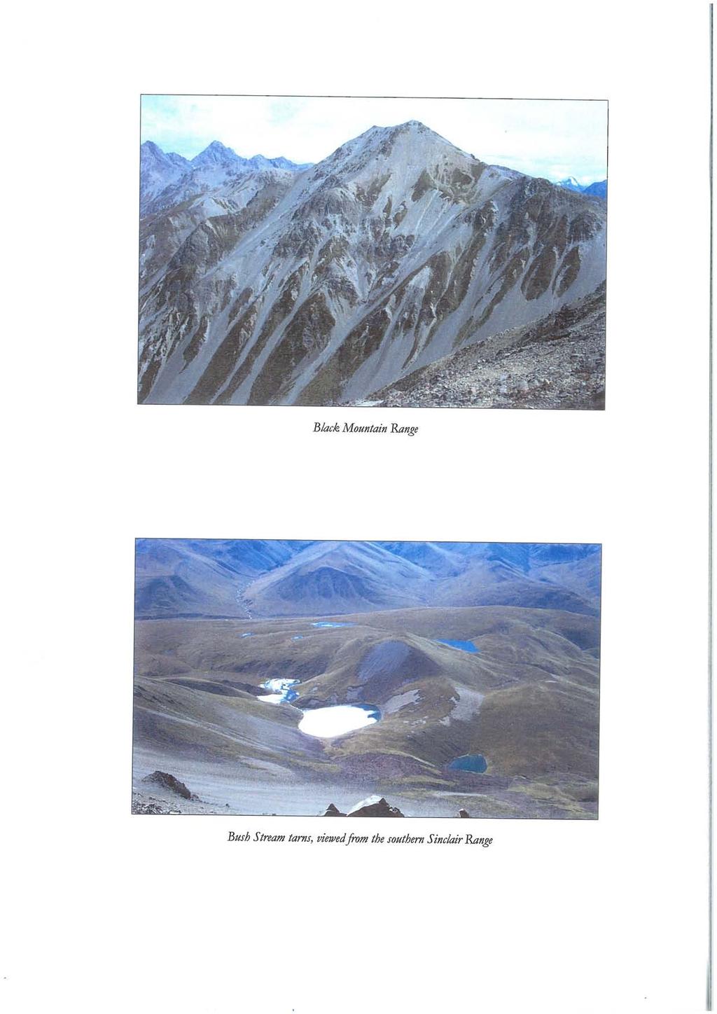
40
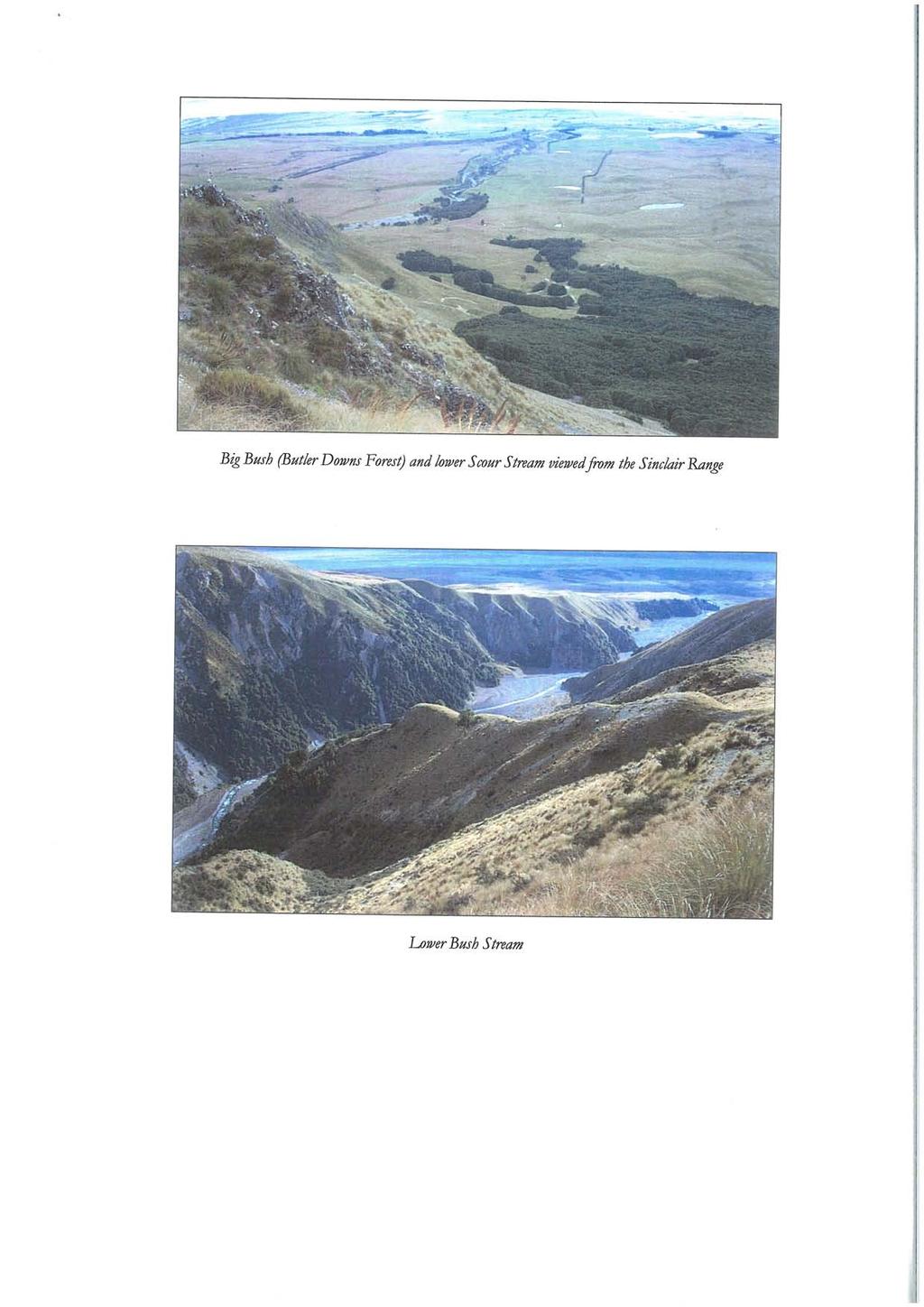
41
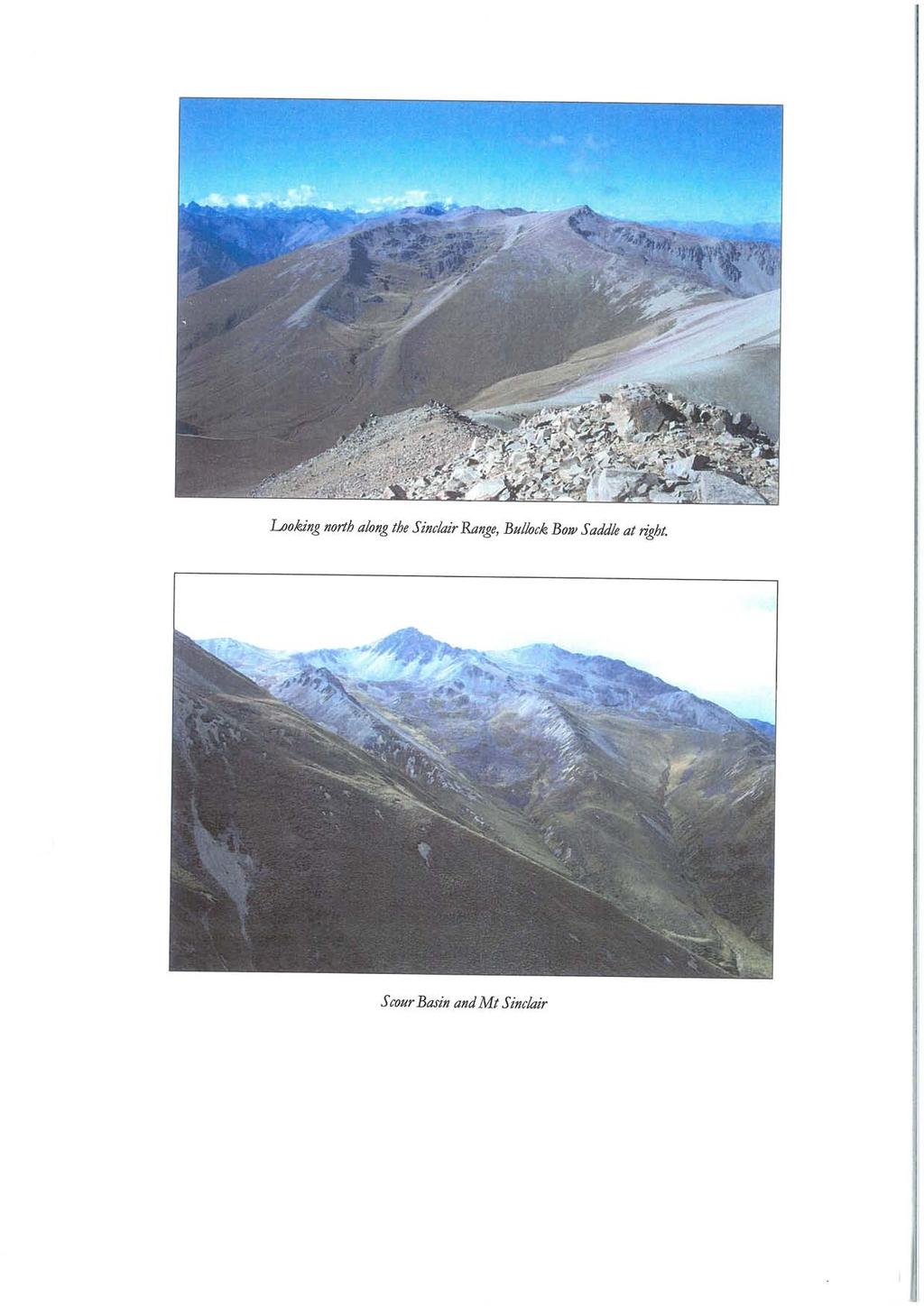
42
Significant Natural Area Assessment. Property Name: Hillend Station
 Private Bag 50072, Queenstown 9348, New Zealand QUEENSTOWN, 10 Gorge Road, Phone +64 3 441 0499, Fax +64 3 450 2223 WANAKA, 47 Ardmore Street, Phone +64 3 443 0024, Fax +64 3 450 2223 Significant Natural
Region 1 Piney Woods
 Region 1 Piney Woods Piney Woods 1. This ecoregion is found in East Texas. 2. Climate: average annual rainfall of 36 to 50 inches is fairly uniformly distributed throughout the year, and humidity and temperatures
CANTERBURY LAND PROTECTION STRATEGY
 CANTERBURY LAND PROTECTION STRATEGY A REPORT TO THE NATURE HERITAGE FUND COMMITTEE M.A. HARDING CANTERBURY LAND PROTECTION STRATEGY Published by the Nature Heritage Fund PO Box 10-420 Wellington June 2009
Rogue Gorge (Mt. Stella) Roadless Area-- T30S R3E (primarily in portions of Sections 23, 26, 33, 34 & 35)
 Roadless Area-- T30S R3E (primarily in portions of Sections 23, 26, 33, 34 & 35)") Rogue Gorge (Mt. Stella) Roadless Area-- T30S R3E (primarily in portions of Sections 23, 26, 33, 34 & 35) Rogue River-Siskiyou National Forest--High Cascades Ranger District Upper, higher elevation trail
Rogue Gorge (Mt. Stella) Roadless Area-- T30S R3E (primarily in portions of Sections 23, 26, 33, 34 & 35) Rogue River-Siskiyou National Forest--High Cascades Ranger District Upper, higher elevation trail
1.1.1 Landscape character This is the upper part of a bowl-shaped landform, extending east from the Rothiemurchus character area, contained by the
 1.1 Glen More 1.1.1 Landscape character This is the upper part of a bowl-shaped landform, extending east from the Rothiemurchus character area, contained by the arc of the high granite pluton of the Cairngorms
Te Manahuna Consulting
 Assessment of the natural values at the proposed centre pivot irrigation site and surrounds on Ben Ohau Station, Mackenzie Basin, New Zealand August 2016 Abstract The natural values of the area proposed
VISUAL Impact Assessment
 5.0 Existing Landscape Character TO GOULBURN FEDERAL HIGHWAY 5.1 Landscape Character Units Generally one of the first steps in carrying out a landscape and visual assessment is to identify and map the
47I THE LAS ANIMAS GLACIER.
 THE LAS ANIMAS GLACIER. ONE of the largest of the extinct glaciers of the Rocky Mountains was that which occupied the valley of the Las Animas river. This stream originates in the San Juan mountains in
GLACIER STUDIES OF THE McCALL GLACIER, ALASKA
 GLACIER STUDIES OF THE McCALL GLACIER, ALASKA T John E. Sater* HE McCall Glacier is a long thin body of ice shaped roughly like a crescent. Its overall length is approximately 8 km. and its average width
Summary of Preliminary Proposal
 Crown Pastoral Land Tenure Review Lease name : SIMONS PASS Lease number : PT 019 Summary of Preliminary Proposal A Preliminary Proposal is advertised for public submissions as per Section 43 of the Crown
A trip to Steindalen. - geology and landscape on the way to the glacier. Geoffrey D. Corner
 A TRIP TO STEINDALEN Excursion guide Please take this with you on your trip, but don t leave it behind as litter. A trip to Steindalen - geology and landscape on the way to the glacier A part of Geologiskolen,
What Is An Ecoregion?
 Ecoregions of Texas What Is An Ecoregion? Ecoregion a major ecosystem with distinctive geography, characteristic plants and animals, and ecosystems that receives uniform solar radiation and moisture Sometimes
PHYSICAL GEOGRAPHY GEOGRAPHY EARTH SYSTEMS COASTAL SYSTEMS FLUVIAL SYSTEMS
 PHYSICAL GEOGRAPHY EARTH SYSTEMS FLUVIAL SYSTEMS COASTAL SYSTEMS PHYSICAL GEOGRAPHY CORRIES / CIRQUES A Corrie or Cirque is the armchair shaped hollow that was the birthplace of a glacier. It has steep,
Chapter 16 Glaciers and Glaciations
 Chapter 16 Glaciers and Glaciations Name: Page 419-454 (2nd Ed.) ; Page 406-439 (1st Ed.) Part A: Anticipation Guide: Please read through these statements before reading and mark them as true or false.
Lidar Imagery Reveals Maine's Land Surface in Unprecedented Detail
 Maine Geologic Facts and Localities December, 2011 Lidar Imagery Reveals Maine's Land Surface in Unprecedented Detail Text by Woodrow Thompson, Department of Agriculture, Conservation & Forestry 1 Introduction
Geologic Trips, Sierra Nevada
 ISBN 0-9661316-5-7 GeoPress Excerpt from Geologic Trips, Sierra Nevada by Ted Konigsmark All rights reserved. No part of this book may be reproduced without written permission, except for critical articles
glacier Little Ice Age continental glacier valley glacier ice cap glaciation firn glacial ice plastic flow basal slip Chapter 14
 Little Ice Age glacier valley glacier continental glacier ice cap glaciation firn glacial ice plastic flow basal slip glacial budget zone of accumulation zone of wastage glacial surge abrasion glacial
Vegetation of the Wellington Town Belt Maggy Wassilieff
 Vegetation of the Wellington Town Belt Maggy Wassilieff Over the brink Wellington's Town Belt is a 400ha swathe of vegetation that partially encircles the city. No pre-european forest survived on the Town
Trail Phasing Plan. Note: Trails in the Clear Creek Canyon area (Segments will be finalized in the future to minimize wildlife impacts
 Note: Trails in the Clear Creek Canyon area (Segments 2 5 and a future JCOS connection) will be finalized in the future to minimize wildlife impacts Trail Phasing Plan P Parking 3 Easy Trail Intermediate
Unit 1: Physical Environment Glaciated Landscapes
 Unit 1: Physical Environment Glaciated Landscapes Corries Corries are bowl-shaped hollows high up in the mountains. They are formed in the following way: Snow collects in a hollow on a mountainside (usually
Wicklow Mountains Path Survey
 Wicklow Mountains Path Survey Glenmacnass Tonelagee Start to Finish: O 114 030 to O 085 016 Altitude (lowest highest): 370m 817m Weather: Sunny day, hot Access: Military Road, Glenmacnass Surveyed by:
Red Tarn, Lake District They are all features of glacial erosion
 Ribbon Lake Lake Windermere, Lake District Arete Striding Edge, Lake District 1 2 3 Pyramidal Peak Corrie & Tarn 4 Matterhorn, Switzerland Red Tarn, Lake District They are all features of glacial erosion
NOTICE OF INTENT MAPS WITH DESCRIPTIONS
 NOTICE OF INTENT MAPS WITH DESCRIPTIONS Location Map(s) to Accompany Notice of Intent The small corner map embedded in the lower left corner of the large map above shows the location of the three national
3.0 THE NORTH SASKATCHEWAN IN ALBERTA
 3.0 THE NORTH SASKATCHEWAN IN ALBERTA 3.1 WATERSHED OVERVIEW Wherever you are on earth, you are in a watershed. Most of the rain and snow falling outside your window will eventually find its way to a local
Reservoir Tin workings
 The workings are quite over-grown and covered in moss, suggesting that they date to the earliest period of mining. This is supported by the fact that their head race was cut off by the reservoir (D49/47)
Section 2 North Slope Ecoregions and Climate Scenarios
 Section 2 North Slope Ecoregions and Climate Scenarios North Slope Ecoregions The geographic/ecological scope of the workshop will be freshwater and terrestrial systems of the North Slope of Alaska, with
Glacial Geomorphology Exercise
 James Madison University Field Course in western Ireland Glacial Geomorphology Exercise 3-day road log (abbreviated) Striations Large kame terrace Cirque with moraines Kame delta Striations Eskers Raised
1.4 Understand how moving ice acts as an agent of erosion and deposition. (Chap. 2)
") 1.4 Understand how moving ice acts as an agent of erosion and deposition. (Chap. 2) There are two types of glaciation. Alpine Glaciation Continental Glaciation Distinguish between the terms alpine glaciation
1.4 Understand how moving ice acts as an agent of erosion and deposition. (Chap. 2) There are two types of glaciation. Alpine Glaciation Continental Glaciation Distinguish between the terms alpine glaciation
GLACIATION. The Last Ice Age (see Chapter 12) and. Pleistocene Ice Cap. Glacial Dynamics 10/2/2012. Laurentide Ice Sheet over NYS
 and. Pleistocene Ice Cap. Glacial Dynamics 10/2/2012. Laurentide Ice Sheet over NYS") GLACIATION and New York State Prof. Anthony Grande The Last Ice Age (see Chapter 1) The Pleistocene Epoch began 1.6 mya. During this time, climates grew colder. There were numerous ice ages starting 100,000000
GLACIATION and New York State Prof. Anthony Grande The Last Ice Age (see Chapter 1) The Pleistocene Epoch began 1.6 mya. During this time, climates grew colder. There were numerous ice ages starting 100,000000
Guthega to Mt Twynam. 2183m. 1583m. 6 hrs 45 mins 14.8 km Return. Experienced only. 913m
 Guthega to Mt Twynam 6 hrs 45 mins 14.8 km Return Experienced only 5 913m This walk starts from Guthega and makes its way along the Snowy River to the Illawong Lodge, via the Blue Cow Creek flying fox.
ENVIRONMENT Environmental Service PRKLND REION, Red Deer F1 F F1 L1 F1 L1 M1 F4 F1 F2 F1 F2 L3 L1 F2 L1 L1 Map 2 Dillberry Lake Provincial Park Projec
 ENVIRONMENT Environmental Service PRKLND REION, Red Deer 67 66 68 69 65 64a,b 63 82 70 77 71 78 72 73 74 76 75 40a 40b 41 42 46 60 61 59 58 83 90 89 39 43 38 44 37 45 47 79 80 81 49 50 51 52 48 53 54 55
Looking north from the SW shieling site with Lub na Luachrach in the foreground
 Looking north from the SW shieling site with Lub na Luachrach in the foreground Upper Gleann Goibhre - Shieling sites Two shieling sites in the upper reaches of the Allt Goibhre were visited and recorded
traverse from the outwash plain terminal moraine and recessional (Sag Harbor, Greenport and Southold
 1 27 DEGLACIATION OF EASTERN LONG ISLAND: THE TERMINAL MORAINE. RECESSIONAL MORAINES. OUTWASH PLAINS. PROGLACIAL LAKES AND MELTWATER CHANNELS LES SIRKIN. EARTH SCIENCE. ADELPHI UNIVERSITY. GARDEN CITY.
The Mackenzie Basin ecology and protection
 The Mackenzie Basin ecology and protection Photo Chris Woolmore Nicholas Head Plant Ecologist Acknowledgements Warren Chinn, Joy Comrie, Iain Gover, Di Lucas, Brian Patrick, Geoff Rogers, Susan Walker,
Shrubs and alpine meadows represent the only vegetation cover.
 Saldur river General description The study area is the upper Saldur basin (Eastern Italian Alps), whose elevations range from 2150 m a.s.l. (location of the main monitoring site, LSG) and 3738 m a.s.l.
TREK THE ROCKIES ABOUT THE CHALLENGE TREK THE ROCKIES FOR HIGHLAND HOSPICE CANADA TREK DEMANDING
 TREK THE ROCKIES CANADA TREK DEMANDING ABOUT THE CHALLENGE The Canadian Rockies are justifiably world-famous for their magnificent scenery: the combination of impressive, jagged mountains, bright turquoise
CRAZY HORSE TRAIL GUIDE
 CRAZY HORSE TRAIL GUIDE Abridged Version: July 2016 This is a short form of our interpretive trail guide for the Crazy Horse Trail. The full version of the guide has a more detailed description of the
APPENDIX D: SUSTAINABLE TRAIL DESIGN. APPENDICES Town of Chili Parks and Recreation Master Plan Update
 APPENDIX D: SUSTAINABLE TRAIL DESIGN APPENDICES Town of Chili Parks and Recreation Master Plan Update Sustainable Trail Construction Sustainable trails are defined by the US Forest Service as trails having
Description of Wild Land Area Ben More, Mull Wild Land Area
 08 Description of Wild Land Area 2015 Ben More, Mull Wild Land Area 1 Context This relatively small WLA (area of 87 km 2 ), one of 11 island WLAs, is located in the mountainous heart of the Inner Hebridean
1.15 TONGARIRO GEOTHERMAL FIELD. List of Geothermal Sites. Te Maari Craters. Emerald Lakes. Contract Report No. 2348
 1.15 TONGARIRO GEOTHERMAL FIELD List of Geothermal Sites TGV01 TGV02 TGV03 TGV04 Te Maari Craters Ketetahi Emerald Lakes Red Crater 2011 452 TGV01 Te Maari Craters 0508 WILDNZ www.wildlands.co.nz ± ± 0
Visual and Sensory Aspect
 Updated All Wales LANDMAP Statistics 2017 Visual and Sensory Aspect Final Report for Natural Resources Wales February 2018 Tel: 029 2043 7841 Email: sw@whiteconsultants.co.uk Web: www.whiteconsultants.co.uk
SECTION A: PHYSICAL ATTRIBUTES OF THE STUDY AREA
 INTRODUCTION The study area is located north of Wanaka township between the Clutha River, Aubrey Road, Sticky forest, and Hikuwai Conservation Area. The study area is 255.5ha in area and includes the existing
LITTLE LOST MAN CREEK (LLM) (formerly USGS Gaging Station No )
 (formerly USGS Gaging Station No )") LITTLE LOST MAN CREEK (LLM) (formerly USGS Gaging Station No. 11482468) LOCATION: In Redwood National and State Park approximately 0.8 miles upstream from confluence with Prairie Creek and 3.2 miles northeast
LITTLE LOST MAN CREEK (LLM) (formerly USGS Gaging Station No. 11482468) LOCATION: In Redwood National and State Park approximately 0.8 miles upstream from confluence with Prairie Creek and 3.2 miles northeast
Typical avalanche problems
 Typical avalanche problems The European Avalanche Warning Services (EAWS) describes five typical avalanche problems or situations as they occur in avalanche terrain. The Utah Avalanche Center (UAC) has
2.1 Physical and Biological Description Matabitchuan River Watershed
 2.1 Physical and Biological Description Watershed 2.1.1 Physical Description The system watershed has a total area of about 933 km 2 and is a tributary system to Lake Temiskaming and the Ottawa River Drainage
2.0 PARK VISION AND ROLES
 2.0 PARK VISION AND ROLES 2.1 Significance in the Protected Area System Marble Range and Edge Hills provincial parks protect 6.8% of the Pavillion Ranges Ecosection, which is located in the Southern Interior
Conservation Resources Report - Part 1
 Crown Pastoral Land Tenure Review Lease name : CORONET PEAK Lease number : PO 195 Conservation Resources Report - Part 1 As part of the process of Tenure Review, advice on significant inherent values within
General Summer and Winter Views
 ENVIRONMENTAL INFORMATION REPORT VOLUME 4 APPENDIX 11. 2 General Summer and Winter Views Table of Contents Section APPENDIX 11.2 Page 1 General Views... 1-1 Tansy Lane, Portishead... 1-2 Galingale Way,
Alpine Glacial Features along the Chimney Pond Trail, Baxter State Park, Maine
 Maine Geologic Facts and Localities September, 2009 Alpine Glacial Features along the Chimney Pond Trail, Baxter State Park, Maine 45 54 57.98 N, 68 54 41.48 W Text by Robert A. Johnston, Department of
C E N T R A L C A T S K I L L S
 120 C E N T R A L C A T S K I L L S Central Catskills Once out of the southern parts of the Catskills, the Long Path enters the more well traveled and civilized regions. The trail joins the Devil s Path,
Chapter 8: Colorado Plateau State Highway 141, Dove Creek to Naturita
 State Highway 141 Dove Creek to (61 miles) Summary: Highway 141 heads north from US Highway 491 about two miles northwest of the town of Dove Creek. Initially, the highway runs through gently rolling farming
Conservation Resources Report
 Crown Pastoral Land Tenure Review Lease name : GLEN DENE STATION Lease number : PO 136 Conservation Resources Report As part of the process of Tenure Review, advice on significant inherent values within
1 Glacial Erosion and
 www.ck12.org Chapter 1. Glacial Erosion and Deposition CHAPTER 1 Glacial Erosion and Deposition Lesson Objectives Discuss the different erosional features formed by alpine glaciers. Describe the processes
beach. Make the ford and follow the trail out to the junction with Red Creek Tr in an open grassy area.
 Description: This is a moderate to slightly strenuous 22.8 mile backpack (add 2.6 miles if you do the packless out and back to the Lion s Head) that will have you exploring nearly every thing that is The
Route #2) Mt. Massive - Southwest Slopes
 Mt. Massive - Southwest Slopes") Route #2) Mt. Massive - Southwest Slopes Difficulty: Class 2 Ski: Advanced, D6 / R2 / III Exposure: Summit Elevation: Trailhead Elevation: Elevation Gain: Round-trip Length: Trailhead: County Sheriff:
Route #2) Mt. Massive - Southwest Slopes Difficulty: Class 2 Ski: Advanced, D6 / R2 / III Exposure: Summit Elevation: Trailhead Elevation: Elevation Gain: Round-trip Length: Trailhead: County Sheriff:
SH73 Route Security Strategic Study Project Summary
 November 2009 SH73 Route Security Strategic Study Project Summary Managing Route Security from Springfield to Aickens STATE HIGHWAY 73 SPRINGFIELD TO AICKENS ROUTE SECURITY STRATEGY CONSULTATION 1. Introduction
Gifts of the Glaciers
 Gifts of the Glaciers Gifts of the Glaciers Moving ice of glacier was responsible for water, landforms, and soil characteristics and patterns of today Sculpturing of bedrock materials Glacial Landforms
Significant Natural Area Assessment. Property Name: Cochrane & Ashkel Ltd. Area Size (ha): 5.33
: 5.33") Private Bag 50072, Queenstown 9348, New Zealand QUEENSTOWN, 10 Gorge Road, Phone +64 3 441 0499, Fax +64 3 450 2223 WANAKA, 47 Ardmore Street, Phone +64 3 443 0024, Fax +64 3 450 2223 Significant Natural
Private Bag 50072, Queenstown 9348, New Zealand QUEENSTOWN, 10 Gorge Road, Phone +64 3 441 0499, Fax +64 3 450 2223 WANAKA, 47 Ardmore Street, Phone +64 3 443 0024, Fax +64 3 450 2223 Significant Natural
Subject to sale, withdrawal, or error.
 The Crawford L Bar Ranch is located approximately 40 air miles west of Albuquerque, New Mexico. This ranch truly epitomizes the description of New Mexico being the Land of Enchantment. The topography and
Sakhalin-2 Phase 2 Lenders Monitoring Visit Report Annex D: Individual RoW Descriptions
 Annex D: Individual RoW Descriptions Annex D: Individual RoW Descriptions List of RoW Locations Visited KP River / Location Team Date Visited 12-14 Fault Crossing 1 and adjacent RoW Northern 31 August
Note: Coordinates are provided as Universal Transverse Mercator UTM Zone U21, North American Datum 1983 (NAD 83).
.") Northern Traverse Route Description The Northern Traverse (formerly the North Rim Traverse) is an unmarked and rugged backcountry hiking route. It is known be a demanding hike, because of its terrain and
Northern Traverse Route Description The Northern Traverse (formerly the North Rim Traverse) is an unmarked and rugged backcountry hiking route. It is known be a demanding hike, because of its terrain and
Chapter 20. The Physical Geography of Africa South of the Sahara
 Chapter 20 The Physical Geography of Africa South of the Sahara Chapter Objectives Identify the major landforms, water systems, and natural resources of Africa south of the Sahara. Describe the relationship
Going-to-the-Sun Road, Glacier National Park, MT, USA Avalanche Path Atlas
 Going-to-the-Sun Road, Glacier National Park, MT, USA Avalanche Path Atlas Erich H. Peitzsch Daniel B. Fagre USGS Northern Rocky Mountain Science Center West Glacier, MT, USA Introduction... 2 Overview
2.0 Physical Characteristics
 _ 2.0 Physical Characteristics 2.1 Existing Land Use for the Project The site is comprised of approximately 114 acres bounded by Highway 101 to the north, the existing town of Los Alamos to the east, State
glacial drift: all deposits associated with glaciation; covers 8% of Earth s surface above sealevel, and 25% of North America
 Glacial depositional features glacial drift: all deposits associated with glaciation; covers 8% of Earth s surface above sealevel, and 25% of North America i) nonstratified drift till: transported & deposited
Comparison Pictures of Receding Glaciers
 Comparison Pictures of Receding Glaciers In the photo above, the west shoreline of Muir Inlet in Alaska's Glacier Bay National Park & Preserve is shown as it appeared in 1895. Notice the lack of vegetation
Self-Guided Walk Langdale Pikes. Start & Finish: NT car park (free to members) at Sticklebarn - on the right just beyond the New Dungeon Ghyll hotel.
 at Sticklebarn - on the right just beyond the New Dungeon Ghyll hotel.") Self-Guided Walk Langdale Pikes Key Information These mountains form a collection of spires and cliffs on the north side of Langdale. This walk visits four of the main tops Pavey Ark, Harrison Stickle,
Self-Guided Walk Langdale Pikes Key Information These mountains form a collection of spires and cliffs on the north side of Langdale. This walk visits four of the main tops Pavey Ark, Harrison Stickle,
Seager Wheeler Lake. Representative Area. -- Concept Management Plan --
 Seager Wheeler Lake Representative Area -- Concept Management Plan -- Saskatchewan Environment and Resource Management January, 1999 Saskatchewan s Representative Areas Network Program The Government of
4.1 Landforms. Note: dimensions are specified in mm at the scale of 1: All drawings are at 1:7 500 for clarity only.
 4.1 Landforms Note: dimensions are specified in mm at the scale of 1:15 000. All drawings are at 1:7 500 for clarity only. OM = Outside measure IM = Inside measure CC = Centre to centre 0.2 0.4 OM 0.4
Glaciers. Glacier Dynamics. Glacier Dynamics. Glaciers and Glaciation. Types of Glaciers. Chapter 15
 Chapter 15 Glaciers and Glaciation Glaciers A glacier is a large, permanent (nonseasonal) mass of ice that is formed on land and moves under the force of gravity. Glaciers may form anywhere that snow accumulation
Ep156 Miller's Grove (2.3 ha) TL
 TL") Ep156 Miller's Grove (2.3 ha) TL 520040 Miller's Grove is located just within the extreme eastern boundary of Ongar Great Park, a medieval deer park dating from the 11 th century. This broadleaved woodland
Ep156 Miller's Grove (2.3 ha) TL 520040 Miller's Grove is located just within the extreme eastern boundary of Ongar Great Park, a medieval deer park dating from the 11 th century. This broadleaved woodland
Glaciers and Glaciation Earth - Chapter 18 Stan Hatfield Southwestern Illinois College
 Glaciers and Glaciation Earth - Chapter 18 Stan Hatfield Southwestern Illinois College Glaciers Glaciers are parts of two basic cycles: 1. Hydrologic cycle 2. Rock cycle A glacier is a thick mass of ice
2.1 What is the climate like?
 José Medeiros This fact sheet allows you to see how varied the countryside is across Brazil. 2.1 What is the climate like? Most of Brazil is in the Southern Hemisphere, where the seasons are the opposite
ISOM & ISSOM forbidden symbol comparison
 & forbidden symbol comparison Forbidden symbols and their relatives Symbol 2000 (Long, Middle) 2007 (Sprint) 201 Impassable cliff An impassable cliff, quarry or earth bank (see 106) is shown with a 0.35
GIFFORD PINCHOT NATIONAL FOREST
 GIFFORD PINCHOT NATIONAL FOREST 9341 Wright Meadow 93 Spencer Meadow Spencer Butte 4247' 30 30A 19 24 80 31C Lewis River Lower Falls 5 Quartz Creek 90 Taidnapam Falls Upper Falls 31 Spencer Peak 3861'
Guide Book Excerpts. Wham Ridge 2006
 Guide Book Excerpts Wham Ridge 2006 Approach: Molus Lake / Elk Park / Vestal Creek Roach and Roach Description Take the Durango & Silverton Narrow Gauge train from either Durango or Silverton and get off
Description of Wild Land Area Loch Etive Mountains Wild Land Area
 9 Loch Etive Mountains Wild Land Area 1 Context This large (507 km 2 ) wild land area (WLA) spans the Lochaber and Argyll border, extending between Taynuilt in the west and Bridge of Orchy and Glen Coe
ENVI2030L - ALPINE AND CONTINENTAL GLACIATION
 NAME ENVI2030L - ALPINE AND CONTINENTAL GLACIATION I. Introduction Glaciers are slowly moving ice sheets. They are very effective erosional agents and can drastically modify the landscapes over which they
playwinterpark.com Off The Beaten Path Hikes Hiking Recommendations for the Adventurous Hiker
 playwinterpark.com Off The Beaten Path Hikes Hiking Recommendations for the Adventurous Hiker Hike: Devil s Thumb (difficult) Length: 3.93 miles one-way Elevation: Trailhead 9609 Destination 12,236 Trailhead
Settlement Patterns West of Ma ax Na, Belize
 SETTLEMENT PATTERNS WEST OF MA AX NA, BELIZE 1 Settlement Patterns West of Ma ax Na, Belize Minda J. Hernke Faculty Sponsor: Kathryn Reese-Taylor, Department of Sociology/Archaeology ABSTRACT The focus
FOUNDATIONS OF ARCHAEOLOGY A WALK IN VERNDITCH CHASE
 FOUNDATIONS OF ARCHAEOLOGY A WALK IN VERNDITCH CHASE 1. A Tale of two Long Barrows Long barrows were constructed as earthen or drystone mounds with flanking ditches and acted as funerary monuments during
Kicking the Alpine Plants Out Mountain Goat Wallows In Mount Peale Research Natural Area (La Sal Mountains, Utah)
") Kicking the Alpine Plants Out Mountain Goat Wallows In Mount Peale Research Natural Area (La Sal Mountains, Utah) Marc Coles-Ritchie, Grand Canyon Trust November 21, 2017 Mountain goats are digging up
Kicking the Alpine Plants Out Mountain Goat Wallows In Mount Peale Research Natural Area (La Sal Mountains, Utah) Marc Coles-Ritchie, Grand Canyon Trust November 21, 2017 Mountain goats are digging up
Northland Regional Landscape Assessment Worksheet
 Northland Regional Landscape Assessment Worksheet DESCRIPTION AND CHARACTERISATION Component Land Types Northern and eastern dissected ranges; high relief land type Unit name MT TIGER BUSH AND REMNANTS
Level IV Ecoregions of the Northeast Glacial Lakes Watershed Project Area
 Level IV Ecoregions of the Northeast Glacial Lakes Watershed Project Area Ecoregions are areas having similar ecosystems and environmental resources including geology, physiography, vegetation, climate,
GC 225 Lecture Exam #2
 GC 225 Lecture Exam #2 Direction- path along which something is moving. 3 Types; - COMPASS DIRECTIONAL NAME (32 in total) - BEARING (four 0 o - 90 o ) - AZIMUTHS (0 o - 360 o ) Compass (32 named points)
VOLUME II APPENDIX F DETAILED PHYSICAL DESCRIPTION OF PROJECT RESERVOIRS AND LANDS
 VOLUME II APPENDIX F DETAILED PHYSICAL DESCRIPTION OF PROJECT RESERVOIRS AND LANDS THE CENTRAL NEBRASKA PUBLIC POWER AND IRRIGATION DISTRICT FERC PROJECT NO. 1417 PHYSICAL DESCRIPTION OF PROJECT LANDS
Appendices A (Our ambition for nature (A3 plan) and further information)
 and further information)") Appendices A (Our ambition for nature (A3 plan) and further information) Penny Hill Farm Nature Conservation vision Key: Tenancy boundary Meadow restoration & Mowing/meadow F33 Mowing/meadow Progress towards
Appendices A (Our ambition for nature (A3 plan) and further information) Penny Hill Farm Nature Conservation vision Key: Tenancy boundary Meadow restoration & Mowing/meadow F33 Mowing/meadow Progress towards
Marilla Reservoir to Chestnut Ridge via Marilla Trails and Bullis Hollow Trail east to west
 USGS topographic maps useful to this hike are the Bradford and Stickney 7.5 minute sectionals. These notes are designed to assist in identifying distance and location using geophysical and man-made characteristics
AVALANCHE TERRAIN. Bill Glude Alaska Avalanche Specialists All photos and graphics Bill Glude unless otherwise noted.
 Bill Glude Alaska Avalanche Specialists 20111202 All photos and graphics Bill Glude unless otherwise noted. AVALANCHE TERRAIN The Key Questions 1.) Could the terrain produce an avalanche?! a.) Where you
NWAC Blog. Cornices - don't walk the line! Written by Robert Hahn on March 14, Last update on May 15, 2017.
 NWAC Blog Cornices - don't walk the line! Written by Robert Hahn on March 14, 2017. Last update on May 15, 2017. Human-triggered cornice fall avalanche from March 10th, 2017. The crown release exposed
Camp Jack Wright PERMANENT ORIENTEERING COURSE (2004)
") Camp Jack Wright PERMANENT ORIENTEERING COURSE (2004) WHAT IS ORIENTEERING? The skill which enables a person to navigate with a map. In the competitive sport, the winner is the person who finishes in the
Camp Jack Wright PERMANENT ORIENTEERING COURSE (2004) WHAT IS ORIENTEERING? The skill which enables a person to navigate with a map. In the competitive sport, the winner is the person who finishes in the
Anderson Mt. Proposed Wilderness Additions to the Rogue-Umpqua Divide Wilderness-- T30S R3E (mostly) Sections 4 & 9, and T29S R3E Section 33
 Sections 4 & 9, and T29S R3E Section 33") Anderson Mt. Proposed Wilderness Additions to the Rogue-Umpqua Divide Wilderness-- T30S R3E (mostly) Sections 4 & 9, and T29S R3E Section 33 When the 35,701 acre Rogue-Umpqua Divide Wilderness was designated
Anderson Mt. Proposed Wilderness Additions to the Rogue-Umpqua Divide Wilderness-- T30S R3E (mostly) Sections 4 & 9, and T29S R3E Section 33 When the 35,701 acre Rogue-Umpqua Divide Wilderness was designated
Around and about Geraldine
 Around and about Geraldine A guide to recreational opportunities SOUTH CANTERBURY Track classifications Short walk Easy walking for up to an hour Track is well formed, with an even, welldrained surface.
HYDROLOGY OF GLACIAL LAKES, FORT SISSETON AREA
 PROC. S.D. ACAD. SCI., VOL. 77 (1998) 59 HYDROLOGY OF GLACIAL LAKES, FORT SISSETON AREA Perry H. Rahn Department of Geology & Geological Engineering South Dakota School of Mines and Technology Rapid City,
The Small Swale Resource Overview
 The Small Swale Resource Overview Prepared for: City of Saskatoon Community Services Department City Planning Branch Prepared by: Stantec Consulting Ltd. #100 75 24 th Street East Saskatoon, Saskatchewan
c. 1 inch = 0.6 miles e. 1:100,000 f. 1:250,000 f. 1 inch = 4.0 miles
 High School Advance Geology Map Test 2014 Name Use the information on each map to provide the best answer to the questions. Fill in the bubble of the best answer on your answer sheet. Answer questions
THE GLACIATION OF THE UINTA MOUNTAINS'
 THE GLACIATION OF THE UINTA MOUNTAINS' WALLACE W. ATWOOD The University of Chicago OUTLINE Location and General Physical Features of the Range. The Extent of Glaciation. Comparison of the Glaciation of
READING QUESTIONS: Glaciers GEOL /WI 60 pts. a. Alpine Ice from larger ice masses flowing through a valley to the ocean
 READING QUESTIONS: Glaciers GEOL 131 18/WI 60 pts NAME DUE: Tuesday, March 13 Glaciers: A Part of Two Basic Cycles (p. 192-195) 1. Match each type of glacier to its description: (2 pts) a. Alpine Ice from
Lake Wissota Access Locations within the LaFayette Township. By Chad Martin
 Lake Wissota Access Locations within the LaFayette Township By Chad Martin Anson/ Wissota Access Point # 1 Road: 195 th St. Associated Fire Numbers: 13294 Defining Characteristics: Forested from road
Mountain Footsteps. Photo: Ric Carless
 ho: Ric Carless Road Directions Middle White River FS Roads Deep Lake and Driftwood Lake see page 101, Connor Lakes along Maiyuk Creek see page 105, and for access Top of the World rovincial ark see page