and 322 km (200 miles) wide (Copeland, 1968). Coastal Alabama comprises Mobile and
|
|
|
- Meagan Jordan
- 6 years ago
- Views:
Transcription
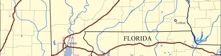
1 Statewide Summary for Alabama By Larry Handley 1, Kathryn Spear 1, Stephen Jones 2, and Cindy Thatcher 1 Background Alabama is over 132,000 km 2 (51,000 miles 2 ) in area, 483 km (300 miles) long, and 322 km (200 miles) wide (Copeland, 1968). Coastal Alabama comprises Mobile and Baldwin Counties and the surrounding State waters in the Gulf of Mexico (Figure 1; O Neil and Mettee, 1982). It is part of both the East Gulf Coastal Plain section of the Coastal Plain province and the Mississippi-Alabama shelf section of the Continental Shelf province. Within the East Gulf Coastal Plain section, Alabama s coastal land falls within the Southern Pine Hills and Coastal Lowlands subdivisions. The Southern Pine Hills subdivision is a sloping landscape composed of sand and clay. Its elevation varies from approximately 30 m (98 ft) near the coast to over 90 m (295 ft) in the northern areas of the two coastal counties. The Coastal Lowlands subdivision is a flat to slightly undulating plain with creeks, rivers, estuaries, and marshes leading to the surrounding bays and the Gulf of Mexico. Offshore Alabama is part of the Mississippi-Alabama section of the Continental Shelf. Barrier islands and spits in coastal Alabama include Dauphin Island, Fort Morgan Peninsula, and Perdido Key. Dauphin Island consists of a beach with dunes on the Gulf side and beaches and marshes on the north side. It was once over 24 km long, but after Hurricane Katrina it has been broken into two distinct islands. Fort Morgan Peninsula is attached to the eastern mainland and extends westward between Mobile Bay and the Gulf of Mexico. A large beach exists on the gulf side, with numerous 1 U.S. Geological Survey National Wetlands Research Center, 700 Cajundome Blvd., Lafayette, LA Geological Survey of Alabama, Geological Investigations Division, 420 Hackberry Lane, Tuscaloosa, AL 35486
2 lagoons and marshes on the bayside. Perdido Key is a narrow peninsula on the easternmost Alabama coast near the Alabama-Florida border, south of Perdido Bay. It consists of beaches and high dunes, with some marshes on the lagoon side of the peninsula. Mobile Bay, parts of Mississippi Sound, Perdido Bay, and many smaller rivers and streams are the main bodies of water in coastal Alabama. Mobile Bay, a submerged river valley, is the largest at 1,070 km 2 (413 miles 2 ) in area and 51.5 km (32 miles) in length (Mobile Bay NEP, 2008). Mobile Bay is 37 km (23 miles) wide at its maximum width near the opening to the Gulf of Mexico at the south end of the bay, and 16.1 km (10 miles) wide at the city of Mobile (Mobile Bay NEP, 2003; Mobile Bay NEP, 2008). It is remarkably shallow with an average depth of 3 m (10 ft), yet it discharges approximately 1,755.6 m 3 (62,000 ft 3 ) of water every second on average (Mobile Bay NEP, 2008). Mississippi Sound runs parallel to the coasts of Mississippi and part of Alabama. The length of the Alabama portion of Mississippi Sound is approximately 26 km (16.2 miles) from the Dauphin Island bridge to the Mississippi-Alabama State line (O Neil and Mettee, 1982). Dauphin Island separates the sound from the Gulf of Mexico. The sound drains into the Gulf of Mexico west of Dauphin Island at Petit Bois Pass, which is approximately 8 km (5 miles) wide. Mississippi Sound averages approximately 3.5 m (11.5 ft) in depth. Salt marshes, large areas of wetland scrub-shrub, and tidal creeks characterize the northern shore of Mississippi Sound, and the southern shore is composed of sandy barrier islands. Perdido Bay is located at the boundary of Baldwin County and Florida s Escambia County. It is approximately 27 km (16.8 miles) long, 5 km (3 miles) at its widest point, and, on average, 2.4 m (7.9 ft) deep. The major fresh-water resource in
3 coastal Alabama is the Mobile River, formed by the confluence of the Alabama and Tombigbee Rivers. The watershed for the Mobile River is approximately 111,369 km 2 (43,000 miles 2 ) large and includes parts of Alabama, Georgia, Mississippi, and Tennessee (Handley et al., 2007). Parts of Alabama and the Florida Panhandle drain into the Perdido River basin and western coastal Alabama drains into the Escatawpa River. Emergent wetlands offer valuable ecological services in coastal Alabama. Marshes provide extensive plant material, which provides energy to the detritus-based estuarine ecological system (O Neil et al., 1983). They provide habitat for many organisms, including shrimp and crabs, whose harvest is a major industry in coastal Alabama. Marshes provide habitat for refuge, feeding, breeding, and spawning. They also remove excess nutrients from water and contribute to erosion control. Degradation of marshes by pollutants, sediments, and other impacts decreases productivity of the entire estuarine ecosystem. Among the nation s states, Alabama ranks fifth in number of different species (144 endemic species), second in number of extinctions that have already occurred (90 extinct species) and fourth in number of species at risk for extinction (14.8% at risk out of 4,533 total species; Stein, 2002). Many species of wildlife benefit from the wetland habitats in coastal Alabama. Numerous bird species can be found in coastal Alabama emergent marshes, which provide habitat for shore- and wading-birds that inhabit salt or brackish water coastal environments (Anderson et al., 1981). Colonial seabirds nest on coastal Alabama s islands, the mainland, and dredge disposal sites (Cooley, 1987). The Mobile-Tensaw Delta and Mobile Bay are the state s primary migratory waterfowl coastal wintering areas (U.S. Fish and Wildlife Service, 1982). The shallow waters, abundance of fish, and vegetative cover in emergent marsh
4 contribute to excellent waterfowl habitat. Emergent wetlands in Alabama also provide habitat for a multitude of endangered species, including various species of raptors and wading- and shorebirds (O Neil et al., 1983). Statewide Status and Trends Monitoring during 1955, 1979, 1988, and 2001/2002 confirms the loss and decline of emergent wetland habitat in coastal Alabama (Table 1, Figures 2-5). Alabama lost 3,822 hectares (9,444 acres), or 14.1 percent, of its emergent wetlands between 1955 and 1979; 7,023 hectares (17,354 acres), or 25.9 percent, between 1979 and 1988; and an additional 3,913 hectares (9,670 acres), or 14.4 percent, between 1988 and 2001/2002. During the complete 47-yr time period this study encompasses, coastal Alabama lost 14,758 hectares (36,468 acres), or 54.4 percent, of the emergent wetlands present in the mid-1950 s. Table 1. Emergent wetland coverage in Alabama for 1955, 1979, 1988, and 2001/2002. Emergent Wetland /2002 Total Change /2002 Type Hectares Acres Hectares Acres Hectares Acres Hectares Acres Hectares Acres Estuarine 15,803 39,049 12,912 31,906 11,873 29,338 10,614 26,229-5,188-12,820 Palustrine 11,326 27,986 10,394 25,685 4,411 10,899 1,756 4,339-9,570-23,647 Total 27,128 67,035 23,306 57,591 16,283 40,237 12,370 30,567-14,758-36,468 Between 1955 and 1979, Alabama lost 2,891 hectares (7,143 acres), or 18.3 percent, of its salt marshes. A loss of 1,039 hectares (2,568 acres), or 6.6 percent, of salt marsh occurred between 1979 and 1988, and another 1,258 hectares (3,110 acres), or 8.0
5 percent, were lost between 1988 and 2001/2002. A total of 5,188 hectares (12,820 acres), or 32.8 percent, of salt marsh was lost during the entire 47-yr study period. Alabama lost 931 hectares (2,301 acres), or 8.2 percent, of coastal fresh marsh between 1955 and A loss of 5,984 hectares (14,786 acres), or 52.8 percent, of fresh marsh occurred between 1979 and Alabama lost 2,655 hectares (6,560 acres), or 23.4 percent, between 1988 and 2001/2002. A total of 9,570 hectares (23,647 acres), or 84.5 percent, of fresh marsh was lost in coastal Alabama throughout the entire 47-yr study period. Causes of Change Emergent wetland ecosystems are sensitive and highly susceptible to ecological damage. Significant threats facing coastal Alabama s emergent wetlands include development and growth industrial, suburban, urban, port, commercial, residential, and recreational as well as oil exploration (Friend et al., 1981). Tourism; ecotourism; recreational and commercial fishing; recreational boating; shipping; and chemical, pulp, and paper production are significant industries in Mobile Bay and coastal Alabama (Mobile Bay NEP, 1997). Despite the approximately $5 billion total investment and 15,000 jobs these industries bring into the community, the growth, development, and environmental stress they create threaten the ecosystem. The Port of Mobile was ranked 8 th in the U.S. in total exports in 1997 and 13 th in foreign waterborne tonnage and is Alabama s only ocean-ship port (Mobile Bay NEP, 2008). Baldwin County, located on the east side of the Bay, experienced a population increase of 75% from 1990 to 2007, with an 89% increase in housing units (Mobile Bay NEP, 2008). The State of Alabama has lost a great deal of its wetlands as a result of increasing population growth and urban
6 development (Mobile Bay NEP, 2008). Wetland loss in northern Mobile Bay was more than four times greater than the national and southeastern average of wetland loss between the mid-1950s and the late 1970s (Burgan and Engle, 2006). Mobile Bay lost over 4,049 ha (10,000 acres) of emergent wetlands between the 1940 s and 1979 (Duke and Kruczynski, 1992). The majority of this loss most likely occurred after WWII with wetland loss relatively stable prior to that. Urban and silvicultural developments were the primary cause of palustrine wetland loss between 1955 and 1979 (Roach et al., 1987). Natural succession; industrial, navigational, and urban development; and erosion were the primary causes of estuarine wetland loss. Erosion was caused and/or exacerbated by reduced upstream sediment input, sea level rise in more recent years, hurricane and storm damage, nutria and muskrat damage, oil and gas exploration, and marsh fires. Dredge and fill projects in coastal Alabama destroy wetlands, and the subsequent pollution and dredge material disposal from development decreases wetland productivity and water quality. Oil spills are a constant threat to the health of coastal Alabama, since exploration began in the 1900s (Friend et al., 1981; U.S. Fish and Wildlife Service, 1982). Oil, gas, and hydrocarbon product extraction are now major industries in coastal Alabama (O Neil et al., 1983). Large volumes of daily waste (although routinely treated, subject to occasional sanitary sewer overflows) can cause bacterial pollution, oxygen depletion, and toxic compound buildup in Alabama s coastal waters (O Neil and Mettee, 1982). Heavy rain in coastal Alabama creates large amounts of runoff carrying nonpoint source pollution, contaminating waters with fertilizers, chemicals, sediment, oil, trash, and sewage (Mobile Bay NEP, 1997). Sea-level rise, along with erosion and shoreline
7 recession caused by waves, tides, and currents, is expected to continue to contribute to more wetland habitat loss (Mobile Bay NEP, 2008). Coastal Alabama lies between the migratory bird Mississippi and Atlantic Flyways and provides critical habitat and renourishment for migratory birds (Mobile Bay NEP, 2003). Many barrier island bird colonies have disappeared because of human disturbance and loss of habitat to development. Draining wetlands has destroyed important habitat for species such as snowy egret, least bittern, and blue-winged teal (Anderson et al., 1981). The presence of wading birds is an indicator of wetland habitat quality; their decline in coastal Alabama suggests the ecosystem is impaired (Mobile Bay NEP, 2003). Ten to twenty percent of Alabama s plant and animal species are threatened by exotic species. More than 80 of these exotic, invasive species are found in waterways and on the coast of Alabama (Mobile Bay NEP, 2008). In addition to the socioeconomic effects that the decline of wildlife species has on local industries such as shellfish harvesting, these declines further degrade the emergent wetland ecosystems in coastal Alabama. Development and industry support the coastal Alabama economy, but they are also dependent on the continued health, sustainability, and production of the water and living resources of the Mobile Bay ecosystem. The loss of Alabama s coastal wetlands remains a threat to the State s ecological and socioeconomic prosperity. Overview of Emergent Wetland Restoration Efforts A review of the Mobile Bay National Estuary Program s Mississippi-Alabama Habitats Tool ( National Estuaries Restoration Inventory ( and Gulf of Mexico Foundation (
8 preservation/) databases with respect to previous emergent vegetation restoration or conservation has mainly been a function of land acquisitions to conservation and protection from the effects of hard shoreline armoring and the removal of invasive species. A very limited amount of emergent vegetation restoration projects has been identified and likely planned to date. The Mobile Bay National Estuary Program s Mississippi-Alabama Habitats Tool contains the most comprehensive list of emergent marsh restoration efforts. The Alonzo Landing Salt Marsh project and the Mon Luis Island Marsh Restoration Phase I are noted in the database as 2004 efforts. Each describes where to protect, enhance, or reestablish marsh habitat lost by erosion. In 2006, the Little Bay Emergency Disaster Relief Program Finfish and Shellfish Habitat Restoration project, located in Mississippi Sound and adjacent to the Bayou la Batre channel to the west, created about 12 hectares (30 acres) of breakwater-protected marsh. Each of the habitat records reviewed in this database indicates a monitoring plan is in place. By 2008, the Mobile County Wildlife and Conservation Association had completed the conversion of a mud flat near Battleship Park into marsh habitat by planting bull tongue, giant bulrush, and black needlerush. Approximately 1.4 hectares (3.5 acres) of Helen Wood Park, Mobile County, was improved between 2007 and 2009 by removal of invasive phragmites and Chinese Tallow, excavation to enhance tidal flooding, and estuarine vegetation plantings. The Nature Conservancy is working on the project : Restore Coastal Alabama Partnership to protect and promote the growth of approximately 405 hectares (1,000 acres) of marsh. This project utilizes breakwaters and includes the installation of approximately 161 km (100 miles) of oyster shell breakwaters.
9 During the development of the Choctaw Point Terminals in north Mobile Bay, the Alabama State Port Authority completed a mitigation project that converted approximately 23 hectares (56 acres) of uplands into tidal fringe marsh at Arlington Cove, North Garrows Bend, and South McDuffie Island (Harris, 2009). Overview of Monitoring, Restoration, and Enhancement Opportunities In 2009, in support of Section 309 of the Coastal Zone Management Act of 1972, the Geological Survey of Alabama began an in-depth investigation to map detailed shoreline protection, generalized shoreline type, and boat ramps, and further, to quantify short-term erosion within Mobile Bay. Currently, no inventory of geographic information system (GIS) thematic layers representing shoreline protection, shoreline type, and comprehensive compilation of public and private boat ramps for coastal Alabama exists. This project was warranted, in part, due to the inherent relationship between the type and geospatial position of shoreline protection and the proximity of shoreline and marsh habitat loss in relation to the protection. This work was finalized in 2012 (Jones et al, 2009; Jones and Tidwell, 2011 and 2012) and is summarized in the following three paragraphs. An estimated 1,323 km (822 miles) of shore protection was mapped for coastal Baldwin and Mobile Counties. The dominant shore protection mapped was natural unretained, determined to be 894 km (555.6 miles) or 67.6 percent of the total. An estimated 32.4 percent of the shoreline mapped is protected by hard armoring type. Bulkheads make up 268 km (166.3 miles) or 20.2 percent of the total and the largest type of hard shore protection mapped. Rubble/riprap makes up 75 km (46.8 miles) or 5.7 percent of the total shore protection in Baldwin and Mobile counties.
10 An estimated 1,326 km (823.5 miles) of shoreline type was mapped for Baldwin and Mobile Counties. The dominant shoreline type was organic, having 594 km (368.9 miles) or 44.8 percent of the total shoreline type mapped. This includes organic marsh, fringe, and forested wetland. Vegetated and sediment types make up 37.1 percent and 12.6 percent of the total shoreline type mapped, respectively. A total of 7,601 selected transects was generated by DSAS and represents shorelines within Mobile Bay, Wolf Bay, Little Lagoon, Cotton Bayou, Terry s Cove, Heron Bay, Fowl River Bay, Portersville Bay, Grand Bay, Isle aux Herbes, and Little Dauphin Island. Areas of greatest erosion were found in Mississippi Sound, specifically the marsh habitat at Isle aux Herbes with a maximum erosion rate of ± 0.66 m/year ( ± 2.17 ft/year) and a mean erosion rate of ± 0.81m/year (-6.92 ± 2.66 ft/year). Although others exist, opportunities tend to be associated with funding sources such as the Coastal Impact Assistance Program, the Forever Wild Program, and Emergency Disaster Relief Programs. Possibly the greatest emergent wetland restoration areas of opportunity exist within Mississippi Sound, where much marsh habitat has been lost to erosion, as well as north Mobile Bay. Established monitoring programs for emergent wetlands in coastal Alabama include the Alabama Department of Conservation and Natural Resources Dauphin Island Sea Lab Emergency Disaster Relief Program Partnership and the Weeks Bay National Estuarine Research Reserve. References Cited Anderson, S.H., Robbins, C.S., and Partelow, J.R., 1981, Habitat Management for Birds
11 of Alabama, Eastern Energy and Land Use Team, U.S. Fish and Wildlife Service, FWS/OBS-81/39.3, 51 p. Burgan, B., and Engle, V., 2006, National Estuary Program Coastal Condition Report: U.S. Environmental Protection Agency 842/B-06/001, 445 p. Cooley, C.D., 1987, Status of Colonial Seabird Resources in Coastal Alabama, In: Symposium on the Natural Resources of the Mobile Bay Estuary, Lowery, T.A., ed., Alabama Sea Grant Extension Service, Mobile, AL, pp Copeland, C.W., ed., 1968, Geology of the Alabama Coastal Plain: A Guidebook, Geological Survey of Alabama, Circular 47, 97 p. Duke, T., and Kruczynski, W.L., 1992, Status and Trends of Emergent and Submerged Vegetated Habitats of Gulf of Mexico Coastal Waters, U.S.A.: U.S. Environmental Protection Agency 800-R , 161 p. Friend, J.H., Lyon, M., Garrett, N., Borom, J.L., Ferguson, J., and Lloyd, G.C., 1981, Alabama coastal region ecological characterization: Volume 3: a socioeconomic study, U.S. Fish and Wildlife Service, Office of Biological Services, Washington, D.C., FWS/OBS-81/41, 367 p. Handley, L., Altsman, D., and DeMay, R., eds., 2007, Seagrass Status and Trends in the Northern Gulf of Mexico: : U.S. Geological Survey Scientific Investigations Report and U.S. Environmental Protection Agency 855- R , 267 p. Harris, Robert C., 2009, Choctaw Point Terminals Mitigation Project, 2009 AAPA
12 Environmental Awards Competion, Mitigation Category; Alabama State Port Authority Jones, S. C., Tidwell, D. K., and Darby, S. B., 2009, Comprehensive shoreline mapping, Baldwin and Mobile Counties, Alabama: Phase I: Alabama Geological Survey, Open-File Report 0921, 80 p. + appendix 22 p. Jones, Stephen C. and Tidwell, David K., 2011, Comprehensive shoreline mapping, Baldwin and Mobile Counties, Alabama: Phase II: Alabama Geological Survey, Open-File Report 1106, 50 p. Jones, Stephen C. and Tidwell, David K., 2012, Comprehensive shoreline mapping, Baldwin and Mobile Counties, Alabama: Phase III: Alabama Geological Survey, Open-File Report 1204, 112 p. Mobile Bay National Estuary Program, 1997, Hard Rain: A Report from the Mobile Bay National Estuary Program. < Mobile Bay National Estuary Program, 2003, Where Rivers Meet the Sea: A Report from the Mobile Bay National Estuary Program. Mobile Bay National Estuary Program, 2008, State of Mobile Bay: A Status Report on Alabama s Coastline from the Delta to Our Coastal Waters, Mobile Bay National Estuary Program. < Final.pdf>
13 National Wetlands Research Center, U.S. Geological Survey, U.S. Department of the Interior, 2007, Mobile Bay, Alabama: Fifty Years of Habitat Change (color poster with maps and text): Lafayette, LA, Scale 1:150,000, USGS-NWRC O Neil, P.E. and Mettee, M.F., 1982, Alabama coastal region ecological characterization, Volume 2: A synthesis of environmental data, U.S. Fish and Wildlife Service, Office of Biological Services, Washington, D.C., FWS/OBS- 82/42, 346 p. O Neil, P.E., Mettee, M.F., McCullough, E.J., and Smith, E., 1983, Sensitivity of Alabama Coastal Shoreline Habitats to Spilled Hydrocarbons, Geological Survey of Alabama, Information Series 63, 76 p. Roach, E.R., Watzin, M.C., Scurry, J.D., and Johnson, J.B., 1987, Wetland Changes in Coastal Alabama, In: Symposium on the Natural Resources of the Mobile Bay Estuary, Lowery, T.A., ed., Alabama Sea Grant Extension Service, Mobile, AL, pp Stein, B.A., 2002, States of the Union: Ranking America s Biodiversity. Arlington, Virginia: NatureServe. U.S. Fish and Wildlife Service, Region IV, 1982, Central Gulf Coast Wetlands Migratory Bird Habitat Preservation Program, Category 9, 103 p.


14 Figure 1. Scope of area for the Alabama summary.

15 Figure 2. Distribution of emergent wetlands in Alabama, 1956.
16 Figure 3. Distribution of emergent wetlands in Alabama, 1979.

17 Figure 4. Distribution of emergent wetlands in Alabama, 1988.


18 Figure 5. Distribution of emergent wetlands in Alabama, 2001/2002.
Title/Name of the area: Chwaka Bay, Zanzibar
 Title/Name of the area: Chwaka Bay, Zanzibar Presented by: Dr. Charles Lugomela, Ag. Head, Department of Aquatic Sciences and Fisheries, University of Dar es Salaam, P.O. Box 35064 Dar es Salaam, Tanzania
Virginian Atlantic (Ecoregion 8)
") Virginian Atlantic (Ecoregion 8) Background The Virginian Atlantic Ecoregion extends from the south side of Cape Cod to Cape Hatteras in North Carolina. The waters of the ecoregion are a mix of cold and
Virginian Atlantic (Ecoregion 8) Background The Virginian Atlantic Ecoregion extends from the south side of Cape Cod to Cape Hatteras in North Carolina. The waters of the ecoregion are a mix of cold and
Pinellas County Environmental Lands
 Pinellas County Environmental Lands In addition to traditional parks and recreation facilities, Pinellas County owns and manages a system of environmental lands that provides specialized resource-based
Unit 1 Lesson 1: Introduction to the Dry Tortugas and Sustainable Seas Expedition
 Unit 1 Lesson 1: Introduction to the Dry Tortugas and Sustainable Seas Expedition Lesson Objectives: Introduce students to the historical, geographic, and ecological importance of the Dry Tortugas. Introduce
Cat Island Chain Background & Access Guide
 Cat Chain Background & Access Guide Brown County Port & Resource Recovery Department 2561 S. Broadway, Green Bay, WI 54304 (920) 492-4950 www.portofgreenbay.com January 2018 1 Restoration of the Cat Chain
Case Study: 1. The Clarence River Catchment
 Case Study: 1. The Clarence River Catchment The NSW coastline is a great natural asset, making an enormous contribution to the economy. The resources of coastal catchments such as the Clarence River Catchment,
Creation of a Community-managed Biodiversity Park in the Saloum Delta of Senegal. Voré Gana Seck Director GREEN Senegal for People, Land, Ocean
 Creation of a Community-managed Biodiversity Park in the Saloum Delta of Senegal Voré Gana Seck Director GREEN Senegal for People, Land, Ocean Rationale for the Creation of the Biodiversity Park F In line
STORNETTA BROTHERS COASTAL RANCH
 STORNETTA BROTHERS COASTAL RANCH Location: Surrounding Point Arena Lighthouse and immediately south of Manchester State Park Mendocino Co., CA Acres: 1,860 Resources: Over two miles of Pacific Ocean coastline
There are actually six geographic sub-regions, three in both the uplands and the lowlands.
 6 Regions of AR Although Arkansas is most easily divided into two distinct geographical regions, the northwestern uplands and the southeastern lowlands, this description does not accurately portray the
An Introduction. The Saginaw River/Bay Area of Concern
 Saginaw River & Bay Area of Concern: Looking Forward Continued Partnerships in the Restoration of Saginaw Bay Michelle Selzer Lake Huron Coordinator & Interim AOC Coordinator Saginaw Bay Watershed Conference
Spatial Distribution and Characteristics of At-Risk Species in the Southeast U.S.
 Nicholas Institute for Environmental Policy Solutions Scoping Document Part 2 Exploratory Analysis of Characteristics and Trends of At-Risk Species in the Southeast U.S. Spatial Distribution and Characteristics
Alaskan/Fjordland Pacific (Ecoregion 22)
") Alaskan/Fjordland Pacific (Ecoregion 22) Background The Alaskan/Fjordland Pacific Ecoregion is an area of abundant marine resources. The ecoregion begins at Vancouver Island and moves up the Gulf of Alaska
Alaskan/Fjordland Pacific (Ecoregion 22) Background The Alaskan/Fjordland Pacific Ecoregion is an area of abundant marine resources. The ecoregion begins at Vancouver Island and moves up the Gulf of Alaska
TOWARDS SUSTAINABLE MANAGEMENT OF MARINE AND COASTAL HABITATS ASIA- PACIFIC DAY FOR THE OCEAN
 TOWARDS SUSTAINABLE MANAGEMENT OF MARINE AND COASTAL HABITATS WANNAKIAT THUBTHIMSANG PHUKET MARINE BIOLOGICAL CENTER, DMCR, THAILAND ASIA- PACIFIC DAY FOR THE OCEAN 20 NOVEMBER 2018, CONFERENCE ROOM 4,
Boatswain bay biodiversity reserve
 Boatswain bay biodiversity reserve March 2003 1 1. Plan and description 1.1. Geographic location, boundaries and dimensions The plan of the proposed Boatswain bay biodiversity reserve and its location
Status of Mangroves in Belize
 Status of Mangroves in Belize State of the Coastal zone Summit June 7 th 2012 Nadia Bood*, Emil Cherrington and Tim Smith Outline Introduction to mangroves Importance of mangrove to Belize National status
Terrestrial Protected Area Nomination: Central Mangrove Wetland South-West, Grand Cayman
 Terrestrial Protected Area Nomination: Central Mangrove Wetland South-West, Grand Cayman The attached nomination, proposing that a parcel of land in the Central Mangrove Wetland be made a Protected Area
Clam Harbour Provincial Park
 Clam Harbour Provincial Park Public Engagement Session Thursday, September 14 th, 2017 5:30pm 7:30pm Webbers Store 11470 Nova Scotia Trunk 7 Lake Charlotte, NS Agenda Overview of the Provincial Parks System
Satoquo SEINO (Graduate School of Engineering, Kyushu University, Japan)
") A reconsideration of horseshoe crab conservation methodology in Japan over the last 100 years and prospects for a marine protected area network in Asian seas Satoquo SEINO (Graduate School of Engineering,
A reconsideration of horseshoe crab conservation methodology in Japan over the last 100 years and prospects for a marine protected area network in Asian seas Satoquo SEINO (Graduate School of Engineering,
X. WHATCOM CREEK SMA. X.1 Watershed Analysis. X.1.1 Landscape Setting
 X. WHATCOM CREEK SMA Summary: The entire length of Whatcom Creek is located within the City of Bellingham. SMA jurisdiction associated with this creek is approximately 300 acres. Land use is dominated
Bon Portage Island Conservation Campaign
 Bon Portage Island Conservation Campaign Protecting a Coastal Treasure Final Report to Nova Scotia Habitat Conservation Fund September 2012 Protection of Bon Portage Island Over the course of this two-year
Town of Oakfield Agricultural and Farmland Protection Plan
 SECTION III COMMUNITY OVERVIEW A. Regional Setting / Location The Town of Oakfield is located in the northwestern portion of Genesee County. Located west of New York's Finger Lakes, the Town is uniquely
March 2, The Honorable Mayor Williams D. Sessoms, Jr. Members of City Council. Subject: Coastal CIP Presentation to City Council - March 6, 2018
 OFFICE OF THE CITY MANAGER (757) 385-4242 (757) 427-5626 FAX MUNICIPAL CENTER BUILDING 1, ROOM 234 2401 COURTHOUSE DRIVE VIRGINIA BEACH, VA 23456-9001 March 2, 2018 The Honorable Mayor Williams D. Sessoms,
SENSITIVE AREAS: PART FIVE - AREAS OF LOCAL CONCERN
 S: PART FIVE - AREAS OF LOCAL CONCERN Some areas within the Cook Inlet Subarea warrant special attention due to the presence of highly productive wildlife habitat, the ability to sustain a large part of
APPENDIX A TERMS OF DESIGNATION
 247 248 ABOUT THIS DOCUMENT On May 11, 1994 the National Oceanic and Atmospheric Administration (NOAA) published the final Olympic Coast National Marine Sanctuary Regulations (59 FR 24586). This official
Region 1 Piney Woods
 Region 1 Piney Woods Piney Woods 1. This ecoregion is found in East Texas. 2. Climate: average annual rainfall of 36 to 50 inches is fairly uniformly distributed throughout the year, and humidity and temperatures
MARINE PROTECTED AREAS LESSON PLAN Water Parks
 Marine Protected Areas U. S. Marine Protected Areas Lesson Plan MARINE PROTECTED AREAS LESSON PLAN Water Parks Theme U.S. Marine Protected Areas Links to Overview Essays and Resources Needed for Student
IMPACTS OF THE RECENT TSUNAMI ON THE BUNDALA NATIONAL PARK THE FIRST RAMSAR WETLAND IN SRI LANKA
 IMPACTS OF THE RECENT TSUNAMI ON THE BUNDALA NATIONAL PARK THE FIRST RAMSAR WETLAND IN SRI LANKA by C.N.B. Bambaradeniya, IUCN The World Conservation Union, Sri Lanka Country Office (Email: cnb@iucnsl.org)
LPBF/UNO APPENDIX A Overlays Maps &
 APPENDIX A Maps & Overlays HOW TO USE THE FOLLOWING MAPS AND S: Several lessons instruct you to use the maps in this Appendix. 1. 2. 3. 4. First, make a transparency of each map required for the activity.
The Casco Bay Estuary Partnership (CBEP, formerly the Casco
 The Casco Bay Estuary Partnership The Casco Bay Estuary Partnership (CBEP, formerly the Casco Bay Estuary Project) is a collaborative effort to preserve and protect the bay s resources. The partners include
Bering Sea Ecoregion Strategic Action Plan
 Bering Sea Ecoregion Strategic Action Plan Part I Map by Shane T. Feirer The Nature Conservancy in Alaska First Iteration September 2005 Part 1. Bering Sea Ecoregion: Strategic Action Plan - First Iteration
Public Lands in Alaska. 200 million acres of federal land - Over 57 Million acres of Wilderness more than half the Wilderness in the entire nation
 Public Lands in Alaska 200 million acres of federal land - Over 57 Million acres of Wilderness more than half the Wilderness in the entire nation alaskawild.org Ground Zero for Climate Change Over the
ICRI Monaco January 2010
 Economic Valuation of Coral Reefs in the Caribbean ICRI Monaco January 2010 Lauretta Burke World Resources Institute (WRI) Beautiful Valuable Valuable Valuable Valuable Valuable Photos: Krishna Desai Valuable
Wetlands Reservoirs of Biodiversity. Billy McCord, SCDNR
 Wetlands Reservoirs of Biodiversity Billy McCord, SCDNR Estuaries Tidal Deepwater Intertidal Salt Marsh Tidal Riverine Fresh & Brackish Deepwater Tidal Emergent Marsh Freshwater Riverine Seasonally Flooded
Mark West Creek Flow Study Report
 Mark West Creek Flow Study Report Biology and Geology of Mark West Creek The headwaters of Mark West Creek are located in the Mayacamas Mountain range, which border Napa and Sonoma County, where it then
2012 Texas Water Conservation Association Meeting
 2012 Texas Water Conservation Association Meeting BG Thomas Kula Southwestern Division Commander 15 June 2012 US Army Corps of Engineers AGENDA UNCLASSIFIED Overview of Southwestern Division Missions Texas
سبل تفعيل تنفيذ ا تفاقية الا راضى الرطبة فى المنطقة العربية
 CONVENTION ON WETLANDS "RAMSAR" AND THE ARAB REGION سبل تفعيل تنفيذ ا تفاقية الا راضى الرطبة فى المنطقة العربية "رامسار" National Institute of Oceanography and Fisheries WETLANDS SERVICES AND PRODUCTS
Biodiversity is life Biodiversity is our life
 Biodiversity is life Biodiversity is our life Chapter 10 Section 2 Biodiversity at Risk Objectives Define and give examples of endangered and threatened species. Describe several ways that species are
Clearwater Lake Provincial Park. Draft Management Plan
 Clearwater Lake Provincial Park Draft Management Plan Clearwater Lake Provincial Park Draft Management Plan Table of Contents 1. Introduction... 3 2. Park History... 4 3. Park Attributes... 4 3.1 Location/Access...4
Hudson Bay Lowlands Proposed Protected Areas
 Hudson Bay Lowlands Proposed Protected Areas Hudson Bay Lowlands Proposed Protected Areas The Protected Areas Initiative has identified portions of the Hudson Bay Lowlands region that have significant
MANAGEMENT DIRECTION STATEMENT June, 1999
 Garibaldi/Sunshine Coast District MAAGEMET DIRECTIO STATEMET June, 1999 for Homathko Estuary Provincial Park Ministry of Environment Lands and Parks BC Parks Division TABLE OF COTETS Introduction...1
Decision Memo for Desolation Trail: Mill D to Desolation Lake Trail Relocation
 for Salt Lake County, Utah Uinta-Wasatch-Cache National Forest Salt Lake Ranger District 1. Background The present location of the Desolation Trail (#1159) between Mill D and Desolation Lake follows old
PRESPA BIOSPHERE RESERVE MANAGEMENT MACEDONIAN PERSPECTIVE
 PRESPA BIOSPHERE RESERVE MANAGEMENT MACEDONIAN PERSPECTIVE Secretariat by Ohrid, 10.03.2016 Prespa Ohid TBB reserve Biodiversity richness trans-boundary level Total Species richness Registered over 1500
Phoenix Habitat Restoration Projects
 Phoenix Habitat Restoration Projects Spur Cross Ranch Cave Creek (Estergard) Regional Tree and Shade Summit March 9, 2010 Desert Riparian Ecosystems Healthy riparian areas like this once existed along
Whitemouth Falls Provincial Park. Draft Management Plan
 Whitemouth Falls Provincial Park Draft Management Plan Whitemouth Falls Provincial Park Draft Management Plan Table of Contents 1. Introduction... 3 2. Park History... 3 3. Park Attributes... 4 3.1 Natural...
Information on Ecological and Biological Significant Marine Areas in Albania
 Information on Ecological and Biological Significant Marine Areas in Albania The report is assembled from the draft strategic plan for marine and coastal protected areas in Albania, supported by the GEF-UNDP
Te Arai dune lands. Christine Wild for the Te Arai Beach Preservation Society
 Te Arai dune lands 1 Community concerns about the environmental impacts of increased subdivision provision on the Te Arai dune lands of the Landscape Protection Zone Rural; Mangawhai/Pakiri Christine Wild
Conservation of Critical Environmental Resources in Chatham Park
 Conservation of Critical Environmental Resources in Chatham Park Elaine Chiosso, Haw Riverkeeper Haw River Assembly Haw River As Seen From Chatham Park "Spreading southwestward from the banks of the Haw
On the Edge with Mangroves
 On the Edge with Mangroves (Author s Note: This is the twenty-second in a series of articles by members of the City of Sanibel Vegetation Committee dealing with vegetative matters of concern to island
Access: The rocky shoreline is only accessible via private property.
 10. Whale Cove Site description: Whale Cove is a small cove fringed by private homes and condominiums with diverse and relatively undisturbed rocky intertidal and subtidal habitat located approximately
Potomac Gorge. Resource Booklet. A Natural Monument in the Shadow of National Monuments. Bridging the Watershed. Potomac Gorge 75
 Potomac Gorge Potomac Gorge A Natural Monument in the Shadow of National Monuments Resource Booklet Bridging the Watershed An outreach program of the Alice Ferguson Foundation in partnership with the National
STREAKED HORNED LARK. Conservation of a threatened species in an industrial landscape. Cat Brown US Fish and Wildlife Service
 STREAKED HORNED LARK Conservation of a threatened species in an industrial landscape Cat Brown US Fish and Wildlife Service HISTORICAL & CURRENT RANGE Streaked Horned Lark Distribution Historical Range:
An NPS Wetland of International Significance!
 An NPS Wetland of International Significance! A World Class Tourism Destination Linda Friar Chief of Public Affairs 305-242-7714 Linda_Friar@nps.gov The Everglades - International Recognition as a special
Galveston Bay Estuary Program. Carla G. Guthrie, Ph.D. Galveston Bay Council Member Texas Water Development Board
 Galveston Bay Estuary Program Carla G. Guthrie, Ph.D. Galveston Bay Council Member Texas Water Development Board The statements contained in this presentation are my current views and opinions and are
2.0 Physical Characteristics
 _ 2.0 Physical Characteristics 2.1 Existing Land Use for the Project The site is comprised of approximately 114 acres bounded by Highway 101 to the north, the existing town of Los Alamos to the east, State
Map 1.1 Wenatchee Watershed Land Ownership
 Map 1.1 Wenatchee Watershed Land Ownership Map 1.1 Wenatchee Watershed Land Ownership The Wenatchee watershed lies in the heart of Washington state in Chelan County. Just larger than the state of Rhode
Restoring Great Waters & National Parks for the 2nd Century of the National Park System: A National Overview
 Restoring Great Waters & National Parks for the 2nd Century of the National Park System: A National Overview John Adornato Conference on Ecological and Ecosystem Restoration New Orleans July 29, 2014 National
VARGAS ISLAND PROVINCIAL PARK
 VARGAS ISLAND PROVINCIAL PARK PURPOSE STATEMENT AND ZONING PLAN February 2003 VARGAS ISLAND PROVINCIAL PARK Purpose Statement and Zoning Plan Primary Role The primary role of Vargas Island Park is to protect
SCALING AND AMPLIFYING MPAS FOR THE EFFECTIVE CONSERVATION OF THE CENTER OF CENTER OF MARINE BIODIVERSITY,
 SCALING AND AMPLIFYING MPAS FOR THE EFFECTIVE CONSERVATION OF THE CENTER OF CENTER OF MARINE BIODIVERSITY, THE VERDE ISLAND PASSAGE A. Rex F. Montebon, Ph.D. 2015 EAS Congress Furama Resort, Danang, Vietnam
NARRABEEN LAGOON SUMMIT am Wednesday, 13 April 2005 Warringah Council Chambers, 725 Pittwater Road, Dee Why.
 NARRABEEN LAGOON SUMMIT 9.15 9.30am Wednesday, 13 April 2005 Warringah Council Chambers, 725 Pittwater Road, Dee Why. NSW Minister for the Environment, the Hon. Bob Debus I am very pleased to be here to
Finn Creek Park. Management Direction Statement Amendment
 Finn Creek Park Management Direction Statement Amendment November 2013 Management Direction Statement Amendment Approved by: Jeff Leahy Regional Director, Thompson Cariboo BC Parks November 12, 2013 Date
FECAL COLIFORM MONITORING IN GRAYS HARBOR COUNTY: SUMMARY REPORT OF MONITORING RESULTS FOR
 Chehalis Basin Partnership Fecal Coliform Monitoring in Grays Harbor County: Summary Report of Monitoring Results for 2000-2003 Draft June 30, 2003 Prepared by Tetra Tech/KCM, Inc. 1917 First Avenue, Seattle,
Georgia s Brain Wrinkles. SS8G1c
 Georgia s 2015 Brain Wrinkles SS8G1c There are many different physical features in the state of Georgia. Physical features include bodies of water, deserts, mountain ranges, and other landforms. They are
Alternative 3 Prohibit Road Construction, Reconstruction, and Timber Harvest Except for Stewardship Purposes B Within Inventoried Roadless Areas
 Roadless Area Conservation FEIS Summary Table S-1. Comparison of Key Characteristics and Effects by Prohibition Alternative. The effects summarized in this table A would occur in inventoried roadless areas
SF1363 / HF 1061: Legacy Funding; Conference Agreement
 - Conference 1 Art 1 - Outdoor Heritage Fund 2 3 Prairies 4 WMA, SNA, & Prairie Bank Easement Acq. Phase III 5 Accelerated Prairie Restoration - Phase III 6 MN Buffers for Wildlife & Water 7 Northern Tallgrass
Geographic Response Plan Map: EFL-40 ]^4011. ! Manatee [v NERR. National Park. Naval Facility. Piping Plover. Power Plant. Recreational Fishing
![Geographic Response Plan Map: EFL-40 ]^4011. ! Manatee [v NERR. National Park. Naval Facility. Piping Plover. Power Plant. Recreational Fishing](/thumbs/91/105050028.jpg "Geographic Response Plan Map: EFL-40 ]^4011. ! Manatee [v NERR. National Park. Naval Facility. Piping Plover. Power Plant. Recreational Fishing") 29 22'30"N 81 7'30"W!E(! EFL40-01 Basin Bulow Creek State Park Addison Blockhouse Historic State Park NRC - Ormond Beach Warehouse Equipment Site (ID JAX-E8) River Basin k k Marsh Aquatic Preserve!S( 200
29 22'30"N 81 7'30"W!E(! EFL40-01 Basin Bulow Creek State Park Addison Blockhouse Historic State Park NRC - Ormond Beach Warehouse Equipment Site (ID JAX-E8) River Basin k k Marsh Aquatic Preserve!S( 200
Paul Sturm Roberto Viqueira Ríos
 Paul Sturm Roberto Viqueira Ríos In this talk Brief Background on Land Based Sources Historical Perspective Guánica watershed characteristics/ issues High priority restoration projects Other key issues
Nakina Moraine Provincial Park. Interim Management Statement. Ontario. Ministry of Natural Resources
 Nakina Moraine Provincial Park Interim Management Statement Ontario Ministry of Natural Resources 1999, Queen's Printer for Ontario Printed in Ontario, Canada Additional copies of this publication can
Elkhorn Slough Tidal Wetland Project
 Elkhorn Slough Tidal Wetland Project Joint Meeting Strategic Planning Team and Science Panel September 23, 2009 Funding National Oceanic and Atmospheric Admin. David and Lucille Packard Foundation Resources
BENEFICIAL USE OF DREDGED MATERIAL DISPOSAL HISTORY HOUMA NAVIGATION CANAL, LA
 BENEFICIAL USE OF DREDGED MATERIAL DISPOSAL HISTORY HOUMA NAVIGATION CANAL, LA 1991-2012 The Houma Navigation Canal (HNC) provides a navigation channel between Houma, Louisiana, and the Gulf of Mexico
THAT the Board approve the final proposed concept plan for the Jericho Marginal Wharf site as shown in Figure C-4 of Appendix C.
 Date: January 17, 2012 TO: Board Members Vancouver Park Board FROM: General Manager Parks and Recreation SUBJECT: Jericho Marginal Wharf Phase 2 Concept Plan RECOMMENDATION THAT the Board approve the final
The Geological Pacific Northwest. Wednesday February 6, 2012 Pacific Northwest History Mr. Rice
 The Geological Pacific Northwest Wednesday February 6, 2012 Pacific Northwest History Mr. Rice 1 Free Response #2 Please do not simply list the items for this response. Full sentences!!! Minimum of 3-5
Stakeholder Meeting #1. An Introduction to the Blind Pass Inlet Management Study
 Stakeholder Meeting #1 An Introduction to the Blind Pass Inlet Management Study April 21, 2016 5:30 PM, The Sanctuary, Sanibel Island A World of Solutions 0 Agenda Introductions Study Overview Study Status
LAUNCH OF THE COASTAL ZONE MANAGEMENT TRUST
 A 60km stretch of coastline on the Yucatan Peninsula of Mexico is the testing ground for an idea that could protect fragile environments around the world: insuring coral reefs. The Economist World Ocean
How South Africa is making progress towards the Aichi 2020 Target 11
 How South Africa is making progress towards the Aichi 2020 Target 11 Montreal, Canada 2 May 2016 Oceans and Coasts Content Protected area considerations and progress 1994-2010 Terrestrial Protected Area
1. Overview of Aberdeen Township and Its Waterfront
 Aberdeen 1. Overview of Aberdeen Township and Its Waterfront 1.1 Geographic Overview Aberdeen Township is a suburban township with a land area of 5.45 square miles, with about 2 miles of shoreline along
What is an Marine Protected Area?
 Policies, Issues, and Implications of Marine Protected Areas Kara Anlauf University of Idaho Before the House Subcommittee on Fisheries Conservation, Wildlife and Oceans April 29, 2003 What is an Marine
Appendix C. Past and Current Management of Selected Tidal Wetland Sites
 Appendix C. Past and Current Management of Selected Tidal Wetland Sites Maps and photographs of wetland sites can be found at http://www.elkhornslough.org/tidalwetlandproject. Site 1. Parsons Slough/South
OMINEACA PROVINCIAL PARK
 OMINEACA PROVINCIAL PARK AND PROTECTED AREA PURPOSE STATEMENT AND ZONING PLAN March 2003 OMINECA PROVINCIAL PARK AND PROTECTED AREA Purpose Statement and Zoning Plan Omineca Park and Omineca Protected
Dungeness Recreation Area County Park Master Plan
 Dungeness Recreation Area County Park Public Outreach Meeting October 10, 2007 Project Overview USFWS Site Dungeness Recreation Area County Park Meeting Objectives: Re-Introduce project; provide status
Niagara Natural Heritage Park
 A Future Proposal For the Niagara-on-the-Lake DND Lands....... Parks Canada Lakeshore Road Property 1 May, 2016 The Harmony Residents Group We are proposing a Natural Heritage Park be established on the
port of brisbane Information Guide
 port of brisbane Information Guide A B O U T U S The Port of Brisbane, managed by the Port of Brisbane Pty Ltd, is Queensland s largest general cargo and container port, and a driver of economic growth
CHAPTER III: TRAIL DESIGN STANDARDS, SPECIFICATIONS & PERMITS
 CHAPTER III Trail Design Standards, Specifications & Permits This chapter discusses trail standards, preferred surface types for different activities, permits, and other requirements one must consider
Order of the Minister of Environment #39, August 22, 2011 Tbilisi
 Registration Code 360050000.22.023.016080 Order of the Minister of Environment #39, August 22, 2011 Tbilisi On preparatory stages and procedure of the methodology for Elaborating structure, content and
Department of Environment and Natural Resources
 Department of Environment and Natural Resources Brad Ives Assistant Secretary for Natural Resources brad.ives@ncdenr.gov 919-707-8620 Mitch Gillespie Assistant Secretary for Environment mitch.gillespie@ncdenr.gov
Version Isolated & Non-Waters Only 1 of 3
 APPROVED JURISDICTIONAL DETERMINATION FORM U.S. Army Corps of Engineers SECTION I: BACKGROUND INFORMATION A. REPORT COMPLETION DATE FOR APPROVED JURISDICTIONAL DETERMINATION (JD): July 6, 2010. B. DISTRICT
What Is An Ecoregion?
 Ecoregions of Texas What Is An Ecoregion? Ecoregion a major ecosystem with distinctive geography, characteristic plants and animals, and ecosystems that receives uniform solar radiation and moisture Sometimes
30 November Randall G. Hintz Chief, Operations Support Branch Operations Division. US Army Corps of Engineers BUILDING STRONG
 30 November 2011 Randall G. Hintz Chief, Operations Support Branch Operations Division US Army Corps of Engineers Overview MAINTENANCE PROJECTS Deep Draft Channels Shallow Draft Channels Coastal Inlets
The Use of Low Cost Breakwaters for Mangrove Restoration in Muddy Foreshores
 The Use of Low Cost Breakwaters for Mangrove Restoration in Muddy Foreshores Douglas A. Gaffney, P.E. Ranata Robertson October 23, 2012 The Use of Low Cost Breakwaters for Mangrove Restoration in Muddy
ReefFix. May, For the Organization of American States (OAS) and the Inter-American Biodiversity Information Network (IABIN)
 and the Inter-American Biodiversity Information Network (IABIN)") Fondation pour la Protection de la Biodiversité Marine FoProBiM B.P. 642 www.foprobim.org (mail) 6011 Henning St. Port-au-Prince, Haiti Bethesda, MD 20817 ReefFix Rapid Assessment of the Economic Value
Fondation pour la Protection de la Biodiversité Marine FoProBiM B.P. 642 www.foprobim.org (mail) 6011 Henning St. Port-au-Prince, Haiti Bethesda, MD 20817 ReefFix Rapid Assessment of the Economic Value
Coverage of Mangrove Ecosystem along Three Coastal Zones of Puerto Rico using IKONOS Sensor
 Coverage of Mangrove Ecosystem along Three Coastal Zones of Puerto Rico using IKONOS Sensor Jennifer Toledo Rivera Geology Department, University of Puerto Rico, Mayagüez Campus P.O. Box 9017 Mayagüez,
Arts + Culture Business + Economy Education Environment + Energy Health + Medicine Politics + Society Science + Technology
 Edition: Australia Job Board Donate Get newsletter Dashboard Thomas Wernberg 22 Search analysis, research, academics Academic rigour, journalistic flair Arts + Culture Business + Economy Education Environment
The Vjosa River in Albania
 The Vjosa River in Albania Europe s Wild jewel - beautiful, unknown and threatened The extensive braided river section near Tepelena would drown in a reservoir of the future Kalivaç dam. (Romy Durst) Major
Watchorn Provincial Park. Management Plan
 Watchorn Provincial Park Management Plan 2 Watchorn Provincial Park Table of Contents 1. Introduction... 3 2. Park History... 3 3. Park Attributes... 3 3.1 Natural... 4 3.2 Recreational... 4 3.3 Additional
The Regional Coral Reef Task Force and Action plan. 27 th ICRI. Cairns Australia July 2012
 The Regional Coral Reef Task Force and Action plan 27 th ICRI Cairns Australia July 2012 Western Indian Ocean Region East Africa mainland states Indian Ocean Islands states Biogeographic division of the
Monitoring the Environmental Status of the Heart of Borneo
 Monitoring the Environmental Status of the Heart of Borneo By: Stephan Wulffraat The Heart of Borneo conservation initiative has been going on now for several years and has gained increasing support from
DREDGED MATERIAL DISPOSAL HISTORY AVOCA ISLAND LAKE
 DREDGED MATERIAL DISPOSAL HISTORY AVOCA ISLAND LAKE The Atchafalaya River & Bayous Chene, Boeuf, & Black, Louisiana, project was authorized by the Rivers and Harbors Act of 1968, House Document 155, 90
Lecture 08, 22 Sep 2003 Role Playing. Conservation Biology ECOL 406R/506R University of Arizona Fall Kevin Bonine
 Lecture 08, 22 Sep 2003 Role Playing Conservation Biology ECOL 406R/506R University of Arizona Fall 2003 Kevin Bonine 1. Role Playing Exercise 2. Exam Wed -group portion outside - ~40 minutes individual,
Twelve Apostles Marine National Park Australia
 EVALUATION REPORT Twelve Apostles Marine National Park Australia Location: Victoria, Australia coastal waters Global Ocean Refuge Status: Nominated (2017), Evaluated (2017) MPAtlas.org ID: 7703885 Manager(s):
Prosjekt Amvrakikos Gulf, Greece
 Prosjekt Amvrakikos Gulf, Greece PERIODE 2012-2015 LAND Amvrakikos Gulf is a special ecosystem located in Western Greece. Amvrakikos Gulf is shared by 3 prefectures: the prefecture of Etoloakarnania (whole
Congo names four large Ramsar sites
 Congo names four large Ramsar sites 1 February 2008 Congo The Republic of Congo designates four sites on World Wetlands Day 2008 The Direction Générale de l'environnement of the Republic of Congo has taken