Guide to Pinellas County. Blueways. Prepared by THE PINELLAS COUNTY PLANNING DEPARTMENT December, 2006
|
|
|
- Scot Whitehead
- 6 years ago
- Views:
Transcription

1
2 Guide to Pinellas County Blueways Prepared by THE PINELLAS COUNTY PLANNING DEPARTMENT December, 2006

3 P inellas County has miles of beautiful shoreline, providing paddlers with a variety of opportunities and experiences as they explore the coastline and the rich array of marine and estuarine ecosystems that make up Pinellas County s waters. We invite paddlers to come and enjoy the placid waters of Tampa Bay and the shores of the Gulf of Mexico. This Guide is designed to provide information on Pinellas County paddling opportunities useful to both residents and visitors. For the purposes of this Guide, the County is divided into sections, making it easier to follow and allowing the reader to pinpoint particular paddling opportunities in a specific geographic area of interest. The Guide provides detailed information for each designated launch point, as well as information on the paddling trail experience. It is important to emphasize that each paddling opportunity is unique, with unique experiences and varying distances and levels of difficulty. Please plan your route accordingly and take all proper safety precautions before embarking. Have fun and enjoy the Pinellas County blueways!
4 Florida Circumnavigational Saltwater Paddling Trail... i Legend... 1 Blueways Map Locator...2 Map John Chesnut Park A.L. Anderson Park Craig Park North Anclote Park Fred Howard Park Anclote Key Preserve State Park Sunset Beach Park Three Rooker Bar Live Oak Park Pop Stansell Park Honeymoon Island State Park Map 1 GPS Coordinates...4 Map Live Oak Park Pop Stansell Park Honeymoon Island State Park Dunedin Causeway Dunedin Youth Guild Park Dunedin Marina Caladesi Island State Park Stevenson Creek Seminole Street Boat Ramp Memorial Causeway Clearwater Recreation Complex Sand Key Park Map 2 GPS Coordinates Map Belleair Causeway Park Boulevard Boat Ramp Boca Ciega Millennium Park Del Bello Park Lake Seminole Park Joe s Creek Preserve War Veterans Memorial Park Map 3 GPS Coordinates Table of Contents Map Maximo Park Fort DeSoto Park Skyway Fishing Pier State Park Bay Vista Park Map 5 GPS Coordinates...26 Map Downtown Gulfport Clam Bayou Nature Preserve Maximo Park Fort DeSoto Park Skyway Fishing Pier State Park Bay Vista Park Grandview Park Lassing Park Demen s Landing North Shore Park Coffee Pot Bayou Park Crisp Park Map 6 GPS Coordinates...30 Map Demen s Landing North Shore Park Coffee Pot Bayou Park Crisp Park Weedon Island Preserve Gandy Boulevard Causeway 4 th Street North/Gateway Preserve Map 7 GPS Coordinates...35 Map Allen s Creek Myron A. Smith Bayview Park Cooper s Bayou Safety Harbor Municipal Marina Mobbly Bayou Wilderness Preserve Phillipe Park Map 8 GPS Coordinates...39 Points of Interest...42 Interesting Plants and Animals in the Area...44 Map War Veterans Memorial Park Jungle Prada Park Gulfport Municipal Beach Clam Bayou Nature Preserve Maximo Park Map 4 GPS Coordinates Safety Tips...47 Camping Guidelines & Additional Important Supplies...48 Useful Phone Numbers and Web Links...49

5 FLORIDA CIRCUMNAVIGATIONAL SALTWATER PADDLING TRAIL The State of Florida, through the Office of Greenways and Trails (OGT), has embarked on the task of creating a saltwater paddling trail that will circumvent the coastline of Florida, stretching from Big Lagoon State Park in the panhandle, south to the Keys, and continuing north up the eastern coast to Fort Clinch State Park, near the Georgia border. This project is anticipated to take three years to complete and will include comprehensive mapping of the proposed route, including recommendations for lodging facilities, campsites and a complete support network. Pinellas County, being located on the Gulf coast, will have its own designated segment of this paddling trail. One goal of Pinellas County s Blueways program is to work with the State OGT to identify, verify and promote the paddling trail. Section 8, the portion of the trail slated for Pinellas County, is planned to begin at the Pasco/Pinellas border in the north and continue on past Fort DeSoto in the south. This trail is proposed to follow both the Gulf of Mexico side of our local barrier islands, and the Intracoastal Waterway side. Staff has also begun mapping the proposed route, in coordination with OGT staff, and highlighting those areas that may be of interest to a sea kayaker traversing the Pinellas County segment of the Florida Circumnavigational Saltwater Paddling Trail. The route has been segmented so that those paddlers who do not wish to paddle the entire route in one trip, will be able to easily research their section of interest. OGT hopes that this paddling trail will help to educate paddlers and highlight the diverse environment that Florida has to offer, especially the 37 aquatic preserves through which the trail will pass. Paddlers on the trail will also have access to almost all of Florida s coastal parks, historic sites and recreation areas, requiring the close involvement of many players in the completion of this project. For more information, please visit the State of Florida Office of Greenways and Trails at This site provides the most up-to-date information regarding the paddling trail as well as all maps for the completed segments. i
6 PINELLAS COUNTY BLUEWAYS GUIDE LEGEND Beach Shower NO LANDING Restaurant Camping Parking Restrooms Canoe/Kayak Launch Pay Phone Wildlife Observation Canoe/Kayak Rentals Picnic Tables BBQ Grill Concessions Point of Interest Water Fountain Groceries Post Office Shelters Hotel/Motels Motor Boat Launch 1


7 2
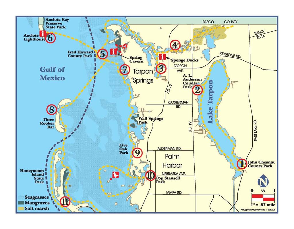
8 3 MAP 1
9 MAP 1: GPS Coordinates for Highlighted Features Reachable from Launch Points* 1. John Chesnut Park Tarpon Turtle Rest Anderson Park Tarpon Turtle Rest Craig Park Sponge Harbor Point ' ' Piney Point Alt. 19 Bridge Over river North Anclote River Howard Park Marked Trail Put-In ' ' Mouth of Lake Avoca ' ' Appox. Center of Lake Avoca ' ' Piney Point Pop Stansell Park ' ' From Park: 1st Spoil Island ' ' Way PT nd Spoil Island ' ' Way Pt rd Spoil Island ' ' Way Pt. 010 (rookery) 4th Spoil Island ' ' Way Pt th Spoil Island ' ' Way Pt th Spoil Island ' ' Way Pt Honeymoon Island Anclote Lighthouse ' ' 7. Sunset Beach Three Rooker Bar ' ' 9. Live Oak Park ' ' Seaside Point Pier *Please see launch point descriptions for details. 4
10 1. JOHN CHESNUT PARK 2200 East Lake Road, Palm Harbor the northwest corner of Lake Tarpon. This restaurant has access via docks and is open seven days a week. Park Telephone: (727) This Pinellas County Park covers approximately 255 acres and is located directly on Lake Tarpon. Raccoons, alligators, various waterfowl, hawks, vultures, tortoises/turtles, snakes, etc. reside in this park and provide interesting viewing for nature enthusiasts and families. This park is a popular launching site for several fishing tournaments each year, so motorized boat traffic can be heavy, especially on the weekends. Launching is available from the concrete boat ramp and parking is available during daylight hours only. The Tarpon Turtle Restaurant is accessible in the northwest corner of the lake and has water access via docks. Park Telephone: (727) A.L. ANDERSON PARK US Hwy. 19, Tarpon Springs This 129-acre Pinellas County Park is characterized by hilly terrain, wooded areas, and beautiful vistas overlooking Salmon Bay and Lake Tarpon. With direct access to Lake Tarpon, paddlers have the opportunity to view a large variety of wildlife; fish, alligators, shorebirds, raccoons, snakes and turtles, to name a few. Launching is available at the motorized boat ramp or from a sandy area to the left of the boat ramp (look for a sign designating canoe and kayak launching). Motorized boat traffic can be heavy on the Lake, especially on the weekends. Parking is available during daylight hours only. Follow the shoreline to the north and you will arrive at the Tarpon Turtle restaurant, located in 3. CRAIG PARK 5 Beekman Way, Tarpon Springs This park is maintained by the City of Tarpon Springs and is located along Spring Bayou. While the park is surrounded mostly by a seawall, there is a boat ramp that can be utilized for canoe and kayak launching. Restrooms are available at the adjacent Recreation Center and there are lodging facilities within walking distance of the park. Spring Bayou is the site of the yearly Epiphany celebration in Tarpon Springs, a centerpiece of the Greek Orthodox religion. Leaving Spring Bayou and heading east, you will enter the Anclote River and find the Sponge Docks of Tarpon Springs. There are not any locations to land here, but from the water you can get an interesting perspective of the sponge industry. The Anclote River is home to a thriving commercial fishing and boating industry. Marinas line the northern side of the river while residential development is common on the southern side. Further upriver, beyond the U.S. Alt. 19 bridge, you will come to North Anclote Park on the northern side of the river. This makes a nice location to rest or have a picnic lunch. If you choose to continue upriver, you will come to a salt marsh environment, the largest of only a few in Pinellas County, which lines the banks of the river. Park telephone: (727)
11 4. NORTH ANCLOTE PARK (No Facilities) 550 Old Dixie Highway, Tarpon Springs Paddlers can use this City of Tarpon Springs Park as a landing site only. The park offers certain amenities, but they are located roughly one mile inland at the park s main entrance. There is no vehicle access to the waterfront. City of Tarpon Springs Parks Dept. (727) FRED HOWARD PARK 1700 Sunset Drive, Tarpon Springs This Pinellas County Park consists of 155 acres and is located on the Gulf of Mexico. Howard Park's location provides access to the Gulf of Mexico by a mile long causeway where canoes and kayaks can launch. Ospreys, herons and eagles may be viewed by park visitors as they fish for food in the surrounding waters. Dolphins, sting rays and occasionally manatees are seen in the area. The park also offers 2.5 miles of marked canoe trails through the mangrove tunnels in the northern portion of the park. These marked trails are tidally influenced. There is also a spring cavern located just west of Howard Park, north of the causeway. Paddle north from Howard Park, following the coastline to the northeast past Piney Point and around Sponge Harbor Point and you will enter the Anclote River. Approximately one mile upriver, you will come to the Tarpon Springs Sponge Docks, home to the local sponge industry. Paddling from Howard Park to the northwest will take you across an approximate 2.5 mile stretch of open water to Anclote Key. Be aware of weather conditions for the day as there is no where to stop and seek shelter if you happen to encounter a fast-moving storm. Park Telephone: (727) ANCLOTE KEY PRESERVE STATE PARK Tarpon Springs This Florida State Preserve is home to at least 43 species of birds, including the bald eagle and the American oystercatcher. This barrier island is an important location for bird-nesting and is accessible only by watercraft. Anclote Key is also the site of a restored, historic lighthouse, once used to guide boats into the Anclote River. The location of this preserve in the Gulf of Mexico allows for excellent fishing and shelling opportunities. Visitors must bring all necessary supplies to the park as amenities are limited. To reach this park, you are required to traverse a 2.5 mile stretch of open water. This area can be the site of rough water. Paddlers should be aware of the conditions and ensure that their watercraft is seaworthy enough to make the trip. Also, severe weather is common on summer afternoons in Pinellas County. Check local weather reports before heading out and prepare to be back to the mainland by early afternoon in the summer. The summer storms are fast-moving and can develop without much warning posing a particular risk when paddling such a great distance over open water. There is no charge for overnight stays in the primitive campground, but campers must first check-in by calling the park before arrival. Park Telephone: (727)
12 7. SUNSET BEACH PARK 1800 Gulf Road, Tarpon Springs This City of Tarpon Springs Park offers direct access to the Gulf of Mexico via its causeway and beach areas. Overnight parking is allowed at the site, but the gates lock at sunset. Be advised to inform the Pinellas County Sheriff s Department ( ) if you intend to leave your vehicle in the park overnight. From this launch, paddlers can either remain along the coastline or venture out into more open water to reach Three Rooker Bar. If remaining along the coastline, travel south and witness the variety of homes lining the waterfront. Pinellas County s Wall Springs Park is located along the shoreline roughly two miles south of the launch point. Wall Springs does not currently have any takeout points, but with a number of mangrove islands along its shoreline, there are excellent wildlife viewing opportunities in the area. Be aware of tide levels in this area as it is possible to become grounded here in an outgoing tide. If paddling out to Three Rooker, be aware of the large volume of motorized boat traffic that may be present in this area, especially on the weekends. Cross boating channels with caution. If leaving the coastline, be prepared to return to the mainland by early afternoon because of fast moving storms which may develop during the summer months. City of Tarpon Springs Parks Dept.: (727) THREE ROOKER BAR (No Facilities) Part of the Anclote Key Preserve State Park, this island is completely natural, without facilities and only accessible by watercraft. Three Rooker is an example of how barrier islands change and shift over time with the currents. Once a small hook-shaped island, Three Rooker became one long, 7 curved land mass, but the island has recently split into two pieces at its center. Because this island has a large bird nesting colony, dogs are not allowed at any time and people are asked to observe wildlife from a distance. Wildlife viewing opportunities include dolphins, shore birds and pelicans. This island is accessible from a number of launch points, including the Dunedin Causeway and Howard Park. Be aware of potential rough water surrounding the island, especially on the Gulf side. Also, be aware of weather conditions as fast-moving storms can develop quickly during summer. Be prepared to return to the mainland by early afternoon in the summer months. Park Telephone: (727) LIVE OAK PARK 600 Crystal Beach Avenue, Palm Harbor This is a Pinellas County Neighborhood Park located on the Intracoastal Waterway, with easy access to the Gulf of Mexico. Kayak launching is available only in designated areas on the beach; look for signage. This facility is located within a short distance of many wildlife-viewing areas, including numerous spoil islands, a bird rookery where landing is not allowed, and expansive beds of seagrasses. There are also many homes lining the waterfront with various types of architecture. If you paddle north from this park, you will come to Pinellas County s Wall Springs Park. Wall Springs does not currently have any take-out points, but with a number of mangrove islands along its shoreline, there are excellent wildlife viewing opportunities in the area. Be aware of tide levels in this area as it is possible to become grounded here in an outgoing tide. South of Live Oak Park is the Seaside Point Pier and the Crystal Beach public
 and there are several restaurants located along US Alternate 19, only a few blocks from the water.")
13 waterfront. Live Oak Park offers limited facilities. A post office is located within a short distance of the park (420 Crystal Beach Avenue) and there are several restaurants located along US Alternate 19, only a few blocks from the water. The Park is operated by the Palm Harbor Parks and Recreation Department, telephone: (727) POP STANSELL PARK 757 Florida Avenue, Palm Harbor 11. HONEYMOON ISLAND STATE PARK Pop Stansell is a Pinellas County Neighborhood Park offering direct access to the Intracoastal Waterway. Launching at this park is available from the sandy beach. Many power boats use this area also, creating a potential parking and safety issue on weekends. Leaving the launch area, and heading west, paddlers will encircle a number of spoil islands, one of which is reserved for bird nesting - please observe from a distance. The water surrounding these islands is a great area to look for fish, such as mullet, which jump from the water, and other aquatic wildlife. The seagrasses in the area also provide important habitat and feeding areas for aquatic life, including the manatee and dolphin. The shores running both north and south of this launch point are lined with large homes of varying architectural backgrounds, offering views of local and imported styles. The Park is operated by the Palm Harbor Parks and Recreation Department, (727) Maintained by the State of Florida, this park boasts several nature trails and bird observation areas. A $1 fee is required if entering the park via kayak, $5 for a vehicle. This park features such wildlife as sea turtles, which come onshore to lay their eggs from May through October, and shorebirds, where species such as least terns and oystercatchers come to lay their eggs. Park managers may rope off some areas in an effort to protect the birds and their nests. Shelling can also be very good because of the island s location in the currents of the Gulf. Parking is only available within the park during daylight hours. This island can be circumnavigated, but be aware of potential rough water on the Gulf side of the island and strong currents in the passes. The eastern side of the island is rich in seagrasses and mangroves, offering a great opportunity for wildlife viewing. Head north from the island and you will come to Three Rooker Bar, a totally natural and undeveloped barrier island only accessible by watercraft. Three Rooker is important for bird nesting and represents how barrier islands shift and change over time. Please observe wildlife from a distance. Park Telephone: (727)
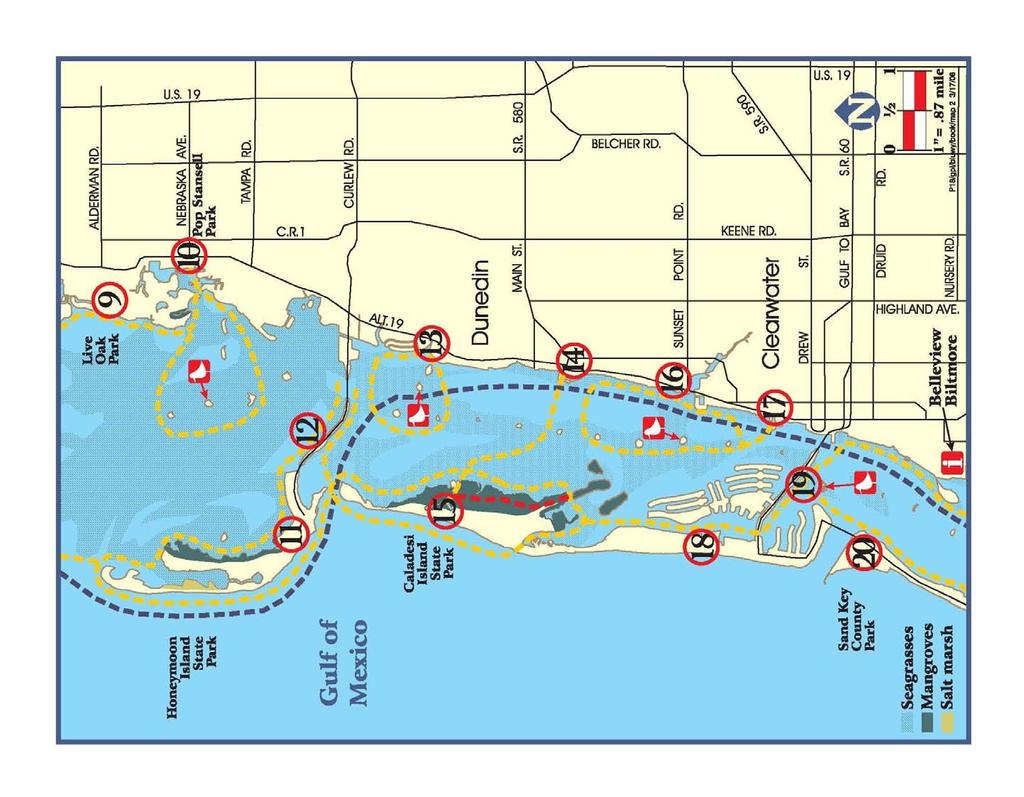
14 9 MAP 2
15 MAP 2: GPS Coordinates for Highlighted Features Reachable from Launch Points* 9. Live Oak Park ' ' Seaside Point Pier ' ' 10. Pop Stansell Park ' ' From Park: 1st Spoil Island ' ' Way PT nd Spoil Island ' ' Way Pt rd Spoil Island ' ' Way Pt. 010 (rookery) 4th Spoil Island ' ' Way Pt th Spoil Island ' ' Way Pt th Spoil Island ' ' Way Pt. 013 Caladesi Is. Mangrove Trail # ' ' End Caladesi Is. Trail # ' ' Portage over South 16. Stevenson Creek Seminole Street Boat Ramp ' Clearwater Recreation Complex Memorial Causeway ' ' 20. Sand Key Park Honeymoon Island Dunedin Causeway (near rentals) ' ' 13. Dunedin Youth Guild Park Dunedin Marina Caladesi Island ' ' Caladesi Is. Marina ' ' Caladesi Is. Mangrove Trail # ' End Caladesi Is. Trail # ' ' *Please see launch point descriptions for details 10
16 9. LIVE OAK PARK See Park description on page POP STANSELL PARK See Park description on page HONEYMOON ISLAND STATE PARK island is an entry for the Caladesi Marina. Follow this trail (be careful to stay outside of the boat channel) to the southeastern portion of the marina. Here, you will find the beginning of a three-mile marked canoe and kayak trail through the mangrove tunnels. There are excellent wildlife viewing opportunities; look out for mangrove crabs and the occasional manatee outside of the tunnels. Under the management of the City of Dunedin Parks Division, Telephone: (727) DUNEDIN YOUTH GUILD PARK 604 Buena Vista Drive North, Dunedin See Park description on page DUNEDIN CAUSEWAY This causeway connects the City of Dunedin mainland to Honeymoon Island State Park and is under the management of Pinellas County. The causeway features parking and sandy beaches stretching almost its entire length, providing plenty of water access for canoe and kayaks. Camping is available on nearby spoil islands, but be aware of no landing signs indicating off-limit bird rookeries. Rental facilities are available on the causeway s southern side. Overnight parking is allowed through the Pinellas County Sheriff s Office, (call ) permit process, free of charge. North of the causeway is Honeymoon Island. This island is home to a large bird-nesting population and a number of other sea animals, including the sea turtle. South of the Causeway is Caladesi Island. Accessible only by watercraft, Caladesi is an undeveloped island covered in native vegetation and surrounded by mangroves. On the northeastern side of the A City of Dunedin Park, this facility features a canoe and kayak launching dock located on a canal with access to the Intracoastal Waterway. Tides heavily influence this launching area. Some portaging may be necessary when the tide is low. Parking is available during daylight hours only. Once you launch, turn west and head out of the canal into the Intracoastal Waterway. To the south and the west of the canal entrance, you will find a series of spoil islands. One of these islands is a bird rookery, so please, enjoy from a distance. These islands offer excellent wildlife viewing opportunities, as well as the surrounding waters which are rich with seagrass beds and provide vital habitat to a variety of shorebirds and fish. Telephone: (727)
17 14. DUNEDIN MARINA 51 Main Street, Dunedin Owned and operated by the City of Dunedin, this marina provides boat ramp, sandy beach and floating dock access to canoes and kayaks. Launching from this location offers access to Caladesi Island to the west, Honeymoon Island to the northwest, and a number of spoil islands throughout the Intracoastal Waterway. Kayak racks are available adjacent to the floating dock for storage of kayaks. There is both a hotel and a restaurant within the marina and overnight parking is allowed near Edgewater Park (eastern edge of the marina). There are also a number of restaurants and local shops within walking distance of the launching area. This area is popular with motorized boaters and there can be very heavy traffic, especially on the weekends. Primitive camping is available on certain spoil islands in the Intracoastal Waterway, but be aware of no landing signs indicating a bird rookery on some of them. Telephone: (727) CALADESI ISLAND STATE PARK Named the 2 nd best natural beach in the nation for 2006, this Florida State Park is one of only a few remaining natural islands in Florida. The island is accessible only by watercraft via a 108-slip marina with sandy beach and floating dock access for canoes and kayaks. The marina creates a high volume of motorized boat traffic, especially on the weekends. Be aware of channel crossings. The island features a three-mile marked canoe and kayak trail through the mangrove tunnels, which begins at the southeast corner 12 of the marina and travels through the eastern side of the island. If you would like to circumnavigate Caladesi, there is a short portage on the southern tip of the island. A hurricane closed this pass a few years ago and the island is now connected with Clearwater Beach to the south. There is also a three-mile upland nature trail and a number of surrounding spoil islands. The waters along the eastern side of the island are lush with seagrass beds, encouraging the presence of marine mammals and numerous species of fish. The island itself is home to a number of nesting birds, including pelicans, snowy egrets and blue herons. There is a $1 fee for landing within the park. Park Telephone: (727) STEVENSON CREEK/EDGEWATER PARK US Alt. 19 North/Sunset Point Road, Clearwater This launch is located adjacent to the Clearwater Shuffleboard Courts and is under the management of the City of Clearwater. This facility has a sandy beach launch located on the southeast side of the US Alt. 19 N bridge and does experience some tidal influence. After launching, paddle west under the bridge and into the Intracoastal Waterway. To the north and west, there are a number of spoil islands and one bird rookery. The large island to the northwest is Caladesi Island. Travel either north or south and circle the islands, each one offering a wildlife viewing opportunity. Be aware of the island marked as a bird rookery and please observe from a distance. It is necessary to cross a boating channel in order to reach these spoil islands. Motorized boat traffic can be heavy here at times, especially on the weekends, so please use caution when crossing the channels. Parking is available here during daylight hours only and the parking area may be
18 influenced by nearby construction. Facilities at Edgewater Park include drinking fountain, benches and trash receptacles. Clearwater Parks & Recreation: (727) , then press SEMINOLE STREET BOAT RAMP Seminole Street/ US Alt 19 North, Clearwater This public boat ramp facility is owned and operated by the City of Clearwater and offers direct access to the Intracoastal Waterway. There is a sandy beach area off to the right of the boat ramps for canoe and kayak access. From here a number of spoil islands can be explored, along with Caladesi Island. This facility can see large numbers of motorized water craft, especially on the weekends, and a channel crossing is necessary to reach Caladesi Island, so use caution. Parking is available 24 hours per day and may be limited on the weekends because of the high traffic volume at this site. Clearwater Parks & Recreation: (727) then press CLEARWATER RECREATION COMPLEX 69 Bay Esplanade, Clearwater Beach This park is owned and operated by the City of Clearwater and offers boat ramp access to the Intracoastal Waterway and a sandy beach for access to the Gulf. Turn north from the boat ramp and head towards Caladesi Island and multiple spoil islands. Caladesi is actually connected with Clearwater Beach because of a hurricane which closed this 13 pass several years ago. The island and the surrounding islands are lined with mangroves on its eastern side and offer a multitude of wildlife viewing opportunities. There is metered parking available at the launch site during daylight hours only. A convenience store and post office are located nearby. Park Telephone: (727) MEMORIAL CAUSEWAY Clearwater Beach This Causeway is under the management of the Florida Department of Transportation and offers a sandy beach for canoes and kayaks to launch from on its southern side. Parking is undesignated and free on the side of the causeway. From here, exploration possibilities include a number of spoil islands (including a few bird rookeries) where landing is not allowed and Caladesi Island. To reach Caladesi, paddle north from the Causeway, following the Clearwater Beach eastern coastline until you reach the unspoiled nature of Caladesi. Once two separate islands, Caladesi Island and Clearwater Beach were connected following a hurricane several years ago. The spoil islands in the Intracoastal Waterway offer opportunities for bird watching, but be aware of those islands marked as bird rookeries and please observe from a distance. South of the launch site is Pinellas County s Sand Key Park. Be cautious if crossing the pass because of strong currents. Also be aware of posted channel markers and motorized boats. The marina facility near the launch site can create a high volume of traffic in the area, especially on the weekends. Clearwater Parks & Recreation: (727) then press 7.

19 20. SAND KEY PARK 1060 Gulf Boulevard, Clearwater This is anticipated to be a future launch site. Park Telephone: (727)
20 15 MAP 3


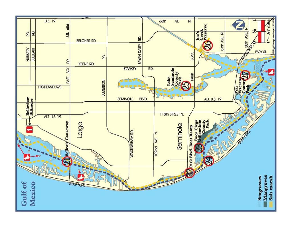
21 MAP 3: GPS Coordinates for Highlighted Features Reachable from Launch Points* 21. Belleair Causeway Park Blvd. Boat Ramp Boca Ciega Millennium Park Del Bello Park Lake Seminole Boat Ramp ' ' 26. Joe's Creek Landing/ Take-Out ' ' Joe's Creek Entrance ' ' 27. War Veterans Memorial Park Launch ' ' * Please see launch point descriptions for details 16
22 21. BELLEAIR CAUSEWAY West Bay Drive, Belleair Bluffs 22. PARK BOULEVARD BOAT RAMP Park Blvd./Gulf Blvd., Indian Shores Belleair Causeway is under the management of Pinellas County and offers a sandy beach for landing and parking. The adjacent boat ramp facility offers overnight parking and a number of amenities. This area can be subject to heavy motorized boat traffic, especially on the weekends. Paddle north from the Causeway and you will come to a number of spoil islands in the Intracoastal Waterway. These islands are home to a variety of shorebirds and have large fish populations in the water surrounding them. Two of islands are bird rookeries so please be aware of signage and observe from a distance. Keep an eye out for the historic Belleview Biltmore Hotel on the eastern shore of the Intracoastal Waterway (a description of the local landmark is on page 41). There is no landing allowed on the Biltmore property, but the site can be observed from the water. South of the causeway are more spoil islands, including one bird rookery. Continuing south, you will enter the Narrows, named for the very narrow width of the Intracoastal Waterway for a two mile stretch. Here, please use caution as the current can be strong and motorized boat traffic can be heavy. At the end of the Narrows is the Park Boulevard Boat Ramp. Lining the coast in this area, you can view a number of impressive homes. There are also mangroves lining much of the eastern coastline, offering excellent wildlife viewing opportunities. Boat Ramp Telephone: (727) This boat ramp is owned and operated by Pinellas County and offers direct access to the Intracoastal Waterway, including a number of spoil islands. Overnight parking is available in the boat ramp parking lot. Paddle north of this site and enter an area called The Narrows, where the width of the Intracoastal Waterway becomes very narrow. Heavy motorized boat use in this area can cause a hazard to small craft. Paddle south from the boat ramp and follow the eastern coastline around the shoreline and you will notice that the water becomes very shallow. Here, you can spot many varieties of fish and jellyfish. Boca Ciega Millennium Park is located to the east of the boat ramp, once you leave the Narrows. This park is lined with mangroves on the waterfront which support a diverse marine population. Continuing along the shoreline past Millennium Park, you will come to War Veterans Memorial Park and the entrance to the Cross Bayou Canal and Long Bayou. Keep an eye out for dolphins and manatees in these areas as well as a large variety of shorebirds. Boat Ramp Telephone: (727)
23 23. BOCA CIEGA MILLENNIUM PARK th Avenue North, Seminole 24. DEL BELLO PARK Gulf Boulevard, Redington Shores The Florida Native Plant Society has recognized this 185- acre Pinellas County Park for its use of native plant species in landscaping. The park s natural communities include pine flatwoods, coastal oak hammock, mangrove swamp, salt marsh, bay head and wetlands. A wide variety of Florida vegetation and wildlife highlights Boca Ciega Millennium Park's delightful environs. Keep an eye out for large numbers of jellyfish near the launching area and to the west of the park, along the coast. The launch area features a sandy beach area and a canoe/kayak washing station. It is tidally influenced, so some short portaging may be necessary to reach Boca Ciega Bay. Primitive camping is available on the spoil island directly south of the launching area. Upon leaving the short tunnel to reach the Bay, paddle to the west and follow the coastline. Here, you will have the opportunity to view a wide variety of fish. Continue towards the west and soon you will come to the Narrows; a very narrow stretch of the Intracoastal Waterway. Turning north into the Intracoastal Waterway will bring you to the Park Boulevard Boat Ramp. Along the coastline, look for a wide variety of impressive homes of varying architectural styles. Paddle to the east following the coastline and soon you will arrive at War Veterans Memorial Park and the entrance to the Cross Bayou Canal, an area frequented by dolphins and manatees. Park Telephone: (727) Owned and operated by the City of Redington Shores, this park provides direct access to the Intracoastal Waterway, via a floating dock. When launching from this site, paddle out of the basin and turn north to travel through the Narrows. Be alert, as motorized boat traffic can be heavy in this area, and the passage is narrow, providing little protection to paddlers. Paddle to the east, and you will come to Boca Ciega Millennium Park, heavy with mangroves and seagrass beds. This park is home to a large variety of wading birds and fish species that thrive off of the vegetation in the area. Paddle southeast and you will enter Boca Ciega Bay. Continue through the Bay to reach War Veterans Memorial Park, Jungle Prada and Cross Bayou. Dolphins are known to frequent this area so keep an eye out for them playing in the water. There are no facilities within the park, but there is a convenience store with a pay phone, a County park with restrooms, showers and water fountains, a motel and a restaurant, all within a short walking distance of the park. Parking is free and is available 24 hours along Gulf Blvd. City of Redington Shores: (727)
24 25. LAKE SEMINOLE PARK Park Boulevard, Seminole Cross Bayou and turn east into Joe s Creek. The landing site is approximately one-half mile into the creek, on the northern bank. Lake Seminole Park is owned and operated by Pinellas County and covers more than 250 acres. Lake Seminole Park is a designated wildlife habitat and sanctuary. Raccoons, alligators, various waterfowl, hawks, bald eagles, black vultures, tortoises/turtles, snakes, etc. reside in this park, and provide viewing opportunities for nature enthusiasts and families. The canoe/kayak launching area is directly south of the boat ramp and features a sandy beach area. Parking is available during daylight hours only. After launching, turn towards the north and paddle along the shoreline of the park. Here, you can observe a wide variety of the wildlife. Further to the north and to the west, you will see a variety of waterfront homes of varying architectural styles. Park Telephone: (727) JOE S CREEK PRESERVE Landing Site Only Park Blvd. / 78 th Street North, St. Petersburg This area is under the management of Pinellas County. The Preserve features a number of spoil islands and undeveloped banks with the opportunity to view various native birds and fish. There is a landing area along Joe s Creek on the northern bank of the waterway. Tides influence the entire preserve area, which may not be accessible in times of low tide. This area is rich with vegetation and fosters a diverse marine environment. Here, you can find excellent wildlife viewing opportunities, observing a number of shorebirds and fish species. This landing site can be reached from both War Veterans and Jungle Prada Park; paddle north into WAR VETERANS MEMORIAL PARK 9600 Bay Pines Boulevard, St. Petersburg War Veterans' Park is owned and operated by Pinellas County and consists of 122 acres located on Boca Ciega Bay with access to the Gulf of Mexico. This park is close to Cross Bayou, Long Bayou and Joe s Creek to the north. After you launch, keep an eye out for dolphins and manatees which have a tendency to frequent this area. Paddle towards the north from the launch point and pass by the motorized boat ramp. Be aware of channel markers as motorized boat traffic can be heavy in the area, especially on the weekends. Once you cross under the bridge (Bay Pines Boulevard), you will enter Long Bayou. If you paddle to the northwest, you will come upon a KOA Kampground ( ) with access to the water. Be aware of numerous oyster beds in this area, especially at low tide. If you want to stay overnight, reservations are recommended. To the northeast is the Cross Bayou canal. This area has a number of spoil islands and vegetation communities, and offers excellent opportunities for wildlife viewing, including dolphins, manatees, egrets and various species of shorebirds. Continue to paddle through the canal and you will come to the entry for Joe s Creek Preserve. This Pinellas County Preserve is host to a variety of species of animals including birds and fish. There is a landing site roughly one-half mile from the entrance to the creek if you choose to stop and rest. This area can be tidally influenced. From this launch
25 site, it is also possible to circumnavigate Treasure Island. Paddle south/southwest from the launch point (be aware of boat traffic) and enter the Gulf of Mexico through John s Pass (see page 41 for more information on this historic fishing village). Use caution as the current in the pass can be very strong and boat traffic can be very heavy. Once in the Gulf, paddle south along the coastline and view the many hotels and condominiums from the water. Keep an eye out for dolphin fishing for dinner off of the beach. Re-enter Boca Ciega Bay through Blind Pass at the southern tip of Treasure Island; this pass separates Treasure Island from St. Pete Beach. This area also can have very strong currents so use caution. Return to the launch point by navigating around the dredged canals, heading to the north/northwest. Overnight parking in War Veterans Park is available at the boat ramp only. The launching area is a sandy beach next to Shelter #5. Park Telephone: (727)
26 21 MAP 4
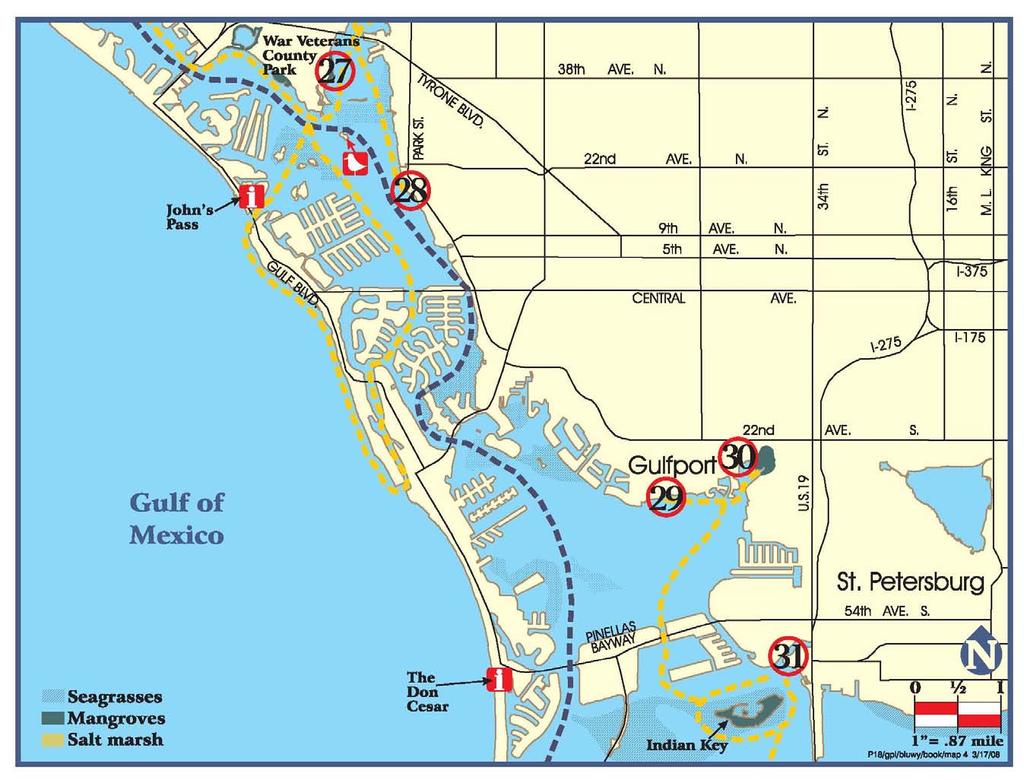
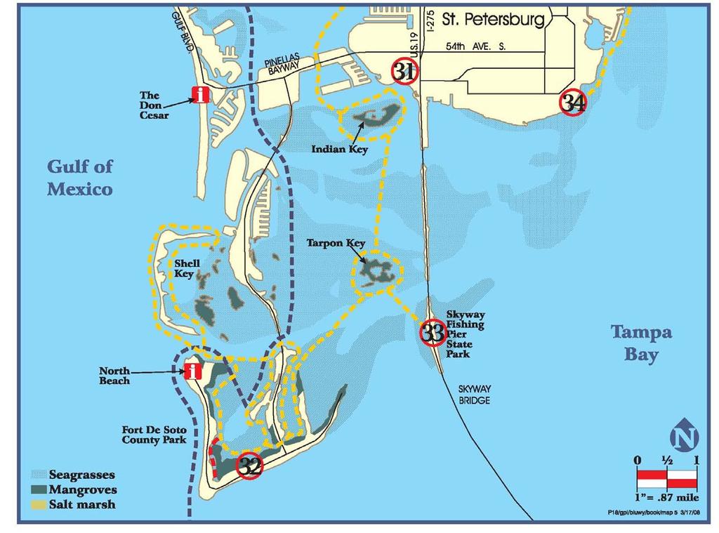
27 MAP 4: GPS Coordinates for Highlighted Features Reachable from Launch Points* 27. War Veterans Mem. Park Launch ' ' 28. Jungle Prada Park ' ' Bird Rookery (near Jungle Prada) ' ' 29. Gulfport Municipal Beach ' ' 30. Clam Bayou Nature Preserve ' ' Indian Key ' ' 31. Maximo Park ' ' Indian Key ' ' * Please see launch point descriptions for details. 22
28 27. WAR VETERANS MEMORIAL PARK 29. GULFPORT MUNICIPAL BEACH See Park description on page JUNGLE PRADA PARK Park Street / Elbow Lane North, St. Petersburg Jungle Prada Park is a small, passive community park owned and operated by the City of St. Petersburg. Jungle Prada has a lengthy history in the City. This park, and the building north, was the site of a commercial complex, complete with a pool, tennis courts and St. Petersburg s first nightclub. It was at this club that Al Capone would visit, Babe Ruth was married and Duke Ellington would entertain. Today, the building houses Saffron s restaurant, complete with an Al Capone dining room and a safe the restaurant claims to have belonged to Al Capone and that has never been opened. This park features boat ramp access and a gravel/rock launching site located on the left side of the large parking lot. Direct access is offered to the Intracoastal Waterway with excellent wildlife viewing opportunities in the area. Paddle northwest from the launch site and in just over one mile, you will come to a bird rookery with many pelicans, please observe from a distance. Continue to the northwest to reach Pinellas County s War Veterans Park. North of this park is the entrance to Long Bayou and the Cross Bayou Canal. Dolphins and hawks can also be seen in the area. It is important to be aware of oyster bars, especially when the tide is low. There is a restaurant located north of Jungle Prada Park and overnight parking is available. City of St. Petersburg Parks and Recreation Department: (727) The City of Gulfport maintains a small beach park in its downtown. There is plenty of free parking along the streets of this quaint, Old-Florida style community. This beach area offers direct access to the Intracoastal Waterway and numerous opportunities for wildlife viewing. Pelicans, shorebirds, manta rays and dolphins have all been seen in this area. This beach park offers many amenities, along with nearby restaurants and a convenience store, all within walking distance. The nearby Clam Bayou Preserve offers even more potential for wildlife sightings. To reach to preserve, paddle east along the shoreline and you will find the bayou before the shoreline turns to the south. Next to the preserve is the Gulfport Municipal Marina, with such amenities as restrooms and a bait shop. City of Gulfport Parks Department: (727) CLAM BAYOU NATURE PRESERVE Miriam Street / 29 th Avenue South, Gulfport Clam Bayou is an estuary where freshwater flows into the salty water of the bay. Here, you can view hermit crabs, ducks, pelicans, nesting egrets, mangrove crabs, manatees, dolphins and a wide variety of fish. Alligators and gopher tortoises have also been spotted in this area. Be aware of oyster beds, especially at low tide. This Preserve is maintained by both the City of Gulfport and the City of St. Petersburg, with launching areas on both Miriam St. S. in Gulfport, and across the water on 34 th Ave. S. in St. Petersburg. Both launches offer crushed shell surfaces.

29 These launches also offer access to Indian Key, part of the Pinellas National Wildlife Refuge, where you can paddle through the mangroves and observe the mangrove crabs and numerous varieties of shorebirds. When launching, follow the shoreline to the south and under one of the Pinellas Bayway bridges. Southeast of these bridges you will see an island covered in mangroves; this is Indian Key. Be aware of motorized boat traffic in the area, especially on the weekends. Clam Bayou Preserve Telephone: (727) or MAXIMO PARK 34 th St. So. / Pinellas Point Dr, St. Petersburg Maximo Park, owned and operated by the City of St. Petersburg, was built on an ancient Indian Mound, still visible in the southern end of the park. This park offers both a sandy beach for launching and a boat ramp that accesses Frenchman s Creek. There can be heavy motorized boat traffic from this site, especially on the weekends. From this park, it is an easy paddle south to Indian Key, part of the Pinellas National Wildlife Refuge (PNWR), where you can view numerous shorebirds and mangrove crabs. The area surrounding the refuge contains large quantities of seagrasses, contributing to the high numbers of fish, dolphins and manatees in the area. Frenchman s Creek is also known to have large numbers of manatees, especially in the winter months. Tarpon Key is the next large island south of Indian Key and, as part of the PNWR, offers paddlers additional wildlife viewing opportunities. (727)
30 25 MAP 5
31 MAP 5: GPS Coordinates for Highlighted Features Reachable from Launch Points* 31. Maximo Park ' ' Indian Key ' ' 32. Fort Desoto No. Beach Put-In ' ' Rest Location (Shell Key) ' ' Billy's Restaurant- Tierra Verde ' ' Fort Desoto Mangrove Trail (not marked) ' ' 33. Skyway Fishing Pier State Park Bay Vista Park ' ' Coquina Key Park ' ' *Please see launch point descriptions for details. 26
32 31. MAXIMO PARK See Park description on page FORT DESOTO PARK 3500 Pinellas Bayway South, Tierra Verde The largest park within the Pinellas County Park System, Fort DeSoto consists of 1,136 acres made up of five interconnected islands. The park s North Beach was named the #1 Beach in America in The park also features a 238-site campground and a historic fort used in the Spanish-American War. Launching here offers numerous wildlife-viewing opportunities. Paddle the park s 2.5 mile marked trail and view shorebirds, fish, dolphins, manatees and three different types of mangroves. Shell Key Preserve is north of Fort DeSoto, and here you can view nesting shorebirds and turtles, or camp in the primitive camping areas on the northern or southern ends of the island (the central section is off limits due to the bird rookery). convenience store and a variety of restaurants. Entering the small channel just east of Shell Key will bring you to Billy s Restaurant and some small shops. There are also numerous spoil islands in the area north of Fort De Soto and east of Shell Key where wildlife is plentiful. This area is also rich in seagrasses, contributing to the abundance of wildlife. South of Fort DeSoto is Egmont Key State Park. Reaching this site requires the crossing of a major shipping channel that is subject to strong currents and is only recommended for experienced paddlers. Launching from North Beach is suggested for this trip. When crossing to Egmont Key, be aware of rough water. Check the local weather forecast before putting-in. In the summer months, fast-moving storms can quickly develop, often doing so in the afternoon, and case pose a threat to those paddling in such open water. Be prepared to be off of the water before early afternoon if planning this trip. Launching is also available from the park s 30-lane boat ramp facility, the largest in the County. This boat ramp is used heavily by motorized boats, as is the channel leading to the Gulf. Be aware of the heavy traffic, especially on the weekends. An 35 toll is required to drive to the park. There is also a short, unmarked mangrove trail only open at high tide (see GPS locations). Park Telephone: (727) For more information regarding plant and animal life in the Shell Key Preserve, please visit: vlands/el6000.html From Shell Key, continue around Tierra Verde to the north and then to the east and you will come to the Tierra Verde Marina. Here you will find restrooms, a bait shop, a 27

33 33. SKYWAY FISHING PIER STATE PARK 33. BAY VISTA PARK th Street, St. Petersburg Located on the North Pier, this site is maintained by the Florida Department of Transportation. A memorial onsite commemorates the sinking of the Coast Guard cutter Blackthorn near this location in There is a sandy beach area next to the parking lot on the western side of the pier where launching is available. There is a $1 toll to access the pier. Paddle northwest from this launch to Tarpon Key, part of the Pinellas National Wildlife Refuge. Seagrasses surround this key, creating a diverse ecosystem featuring dolphins, manatees, and a number of shorebirds and fish. Bay Vista is part of the City of St. Petersburg Parks system. It offers access to Tampa Bay and the southeastern Pinellas County shoreline. There is a concrete boat ramp within the park, and a sandy area just to the left of the entrance for launching. There can be heavy boat traffic from this site, especially on the weekends. This area can be heavily influenced by the tides, especially to the southeast of the park where there are a number of salt flats. Manatees are common in this area, along with dolphins and a wide variety of fish and shorebirds, including pelicans, osprey and sting rays. The salt flats to the southeast offer some of the best fishing opportunities in the area. There is a bird rookery to the north, just south of Coquina Key at the entrance to Little Bayou. This island is home to a large population of pelicans, please observe from a distance. Coquina Key Park is located on the northern side of the Key and offers an excellent location to rest. Parking at Bay Vista is available during daylight hours only. (727)
34 29 MAP 6

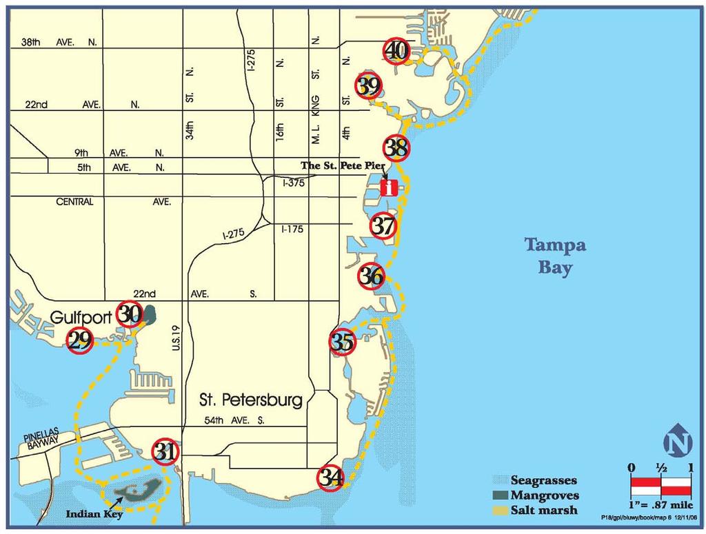
35 MAP 6: GPS Coordinates for Highlighted Features Reachable from Launch Points* 29. Gulfport Beach ' ' Clam Bayou Nature Preserve ' ' 30. Clam Bayou Nature Preserve ' ' Indian Key ' ' 31. Maximo Park ' ' Indian Key ' ' 34. Bay Vista Park ' ' Coquina Key Park ' ' 34. Coquina Key Park ' ' 35. Lassing Park Demen's Landing ' North Shore Park ' ' St. Pete Pier ' ' 39. Coffee Pot Bayou Boat Ramp ' Crisp Park *Please see launch point descriptions for details. 30
36 29. DOWNTOWN GULFPORT 35. GRANDVIEW PARK 6 TH Street / 39 th Avenue South, St. Petersburg See Park description on page CLAM BAYOU NATURE PRESERVE See Park description on page MAXIMO PARK See Park description on page FORT DESOTO PARK See Park description on page 26 A City of St. Petersburg passive park featuring boat ramp access to the water, Grandview offers direct access to Tampa Bay through a waterway known as Big Bayou. There is a small sandy area where launching is possible; look for the break in the mangroves where a number of dinghies are sitting. These boats are used by those mooring in the Bayou to reach the mainland. This area experiences some heavy motorized boat traffic, especially on the weekends. Just outside of Big Bayou lies a large field of seagrass beds, encouraging a variety of fish and shorebirds along the water s edge. Dolphins and manatees are also known to frequent the area. Not far from this location is downtown St. Petersburg, where there are a number of restaurants, hotels and attractions within walking distance of the water. Parking is allowed during daylight hours only. Coquina Key is located right across the Bayou from the launch and the park on the northern side offers an excellent place to rest. Telephone: (727) SKYWAY FISHING PIER STATE PARK See Park description on page BAY VISTA PARK See Park description on page LASSING PARK (No Facilities) Beach Drive / 18 th Way S.E., St. Petersburg Lassing Park is a waterfront beach park maintained by the City of St. Petersburg, without amenities or designated parking. Parking is available along the street in the neighborhood. This park provides access to Tampa Bay and a number of other St. Petersburg locations, including the downtown area where paddlers can find a number of restaurants and hotels within walking distance of the water.
37 This site can also be a great picnic or resting site if launching from other locations in the area. Telephone: (727) NORTH SHORE PARK North Shore Dr/ 10 th Ave. N.E., St. Petersburg 36. DEMEN S LANDING Bayshore Dr. / 2 nd Avenue South, St. Petersburg This City of St. Petersburg Park is located downtown next to the St. Petersburg Pier. This site features many amenities and is within walking distance of numerous hotels, restaurants and attractions. The historic open air post office is also located within walking distance at 76 4 th St. North. Boat ramp access is available for launching and there is ample free parking within the park. Overnight parking is available. After launching, paddle north of the marina and you will see the St. Petersburg Pier (for a complete description see page 42). North of the Pier, you will pass North Shore Park and enter Coffee Pot Bayou where you will see a pelican island just past the first bridge; please observe this rookery from a distance. South of Demen s Landing is the Port of St. Petersburg. In the southwest corner of the port is the entrance to Salt Creek. This creek once flowed through to Lake Maggiore, currently a freshwater Lake. Along the sides of the creek you will see the heart of St. Petersburg s ship and boat repair industry. Continue further south from the port, and you will pass Lassing Park, Big Bayou and Coquina Key. The coastlines here are rich in seagrass beds and offer excellent wildlife viewing opportunities. The homes along the coast are also impressive and are of varying architectural styles. City of St. Petersburg Parks and Recreation Dept: (727) Maintained by the City of St. Petersburg, this park features a large sandy beach area where launching is available. Parking within this park is plentiful, free and available during daylight hours only. This park offers access to Tampa Bay and gives paddlers great views of downtown St. Petersburg from the water. One can view the St. Petersburg Pier, the Vinoy Hotel, and other historic views. Travel north from the park and enter Coffee Pot Bayou. In this body of water, you can find a bird rookery consisting of a large pelican population, please observe from a distance. Manatees, dolphins and a wide variety of fish and shorebirds also frequent the area. Motorized boat traffic is low in the bayou because of low bridges, but can be quite high near the launch point. South of the launch point you will pass downtown St. Petersburg and the Port of St. Petersburg. City of St. Petersburg Parks and Recreation Department Telephone: (727) COFFEE POT BAYOU PARK 1 st St/31 st Avenue N.E., St. Petersburg Owned and operated by the City of St. Petersburg, this park offers boat ramp access at the top of Coffee Pot Bayou. This area is a common place to find manatees, and a wide variety of fish and shorebirds. About 0.75 mile south of the launch is a bird rookery, Pelican Island, that is home to large population of pelicans, please observe from a distance. Boat traffic within this area is light because of


38 low bridges, but can become quite heavy when entering Tampa Bay. Be aware of the channel crossings. South of Coffee Pot Bayou is downtown St. Petersburg. Once entering the bay, St. Petersburg Pier and the Vinoy Hotel can be seen to the south. There are restaurants and a grocery store within walking distance of Coffee Pot Park, further north on 1 st Street. City of St. Petersburg Parks and Recreation Department Telephone: (727) CRISP PARK Poplar/35 th Avenue, N.E., St. Petersburg This City of St. Petersburg Park offers boat ramp access to Tampa Bay. Travel first through the channel and out along the residential coastline of Snell Isle and Shore Acres. Follow the channel to the east and then the south to reach Tampa Bay. A number of species of fish and birds inhabit these channels, co-existing with the large population of people along the water s edge. If you head north in Tampa Bay, you will come to Weedon Island Preserve, home to countless numbers of fish, shorebirds, dolphins, manatees and other animals. Head south in the bay and you will come to downtown St. Petersburg. Parking is available in Crisp Park during daylight hours only. City of St. Petersburg Parks and Recreation Department Telephone: (727)
39 34 Map 7
40 MAP 7: GPS Coordinates for Highlighted Features Reachable from Launch Points* 37. Demen's Landing ' North Shore Park ' ' St. Pete Pier ' ' 39. Coffee Pot Bayou Boat Ramp ' Crisp Park Weedon Island Preserve Gandy Blvd Causeway (south side) ' ' (north side) th Street Launch Site *Please see launch point descriptions for details. 35
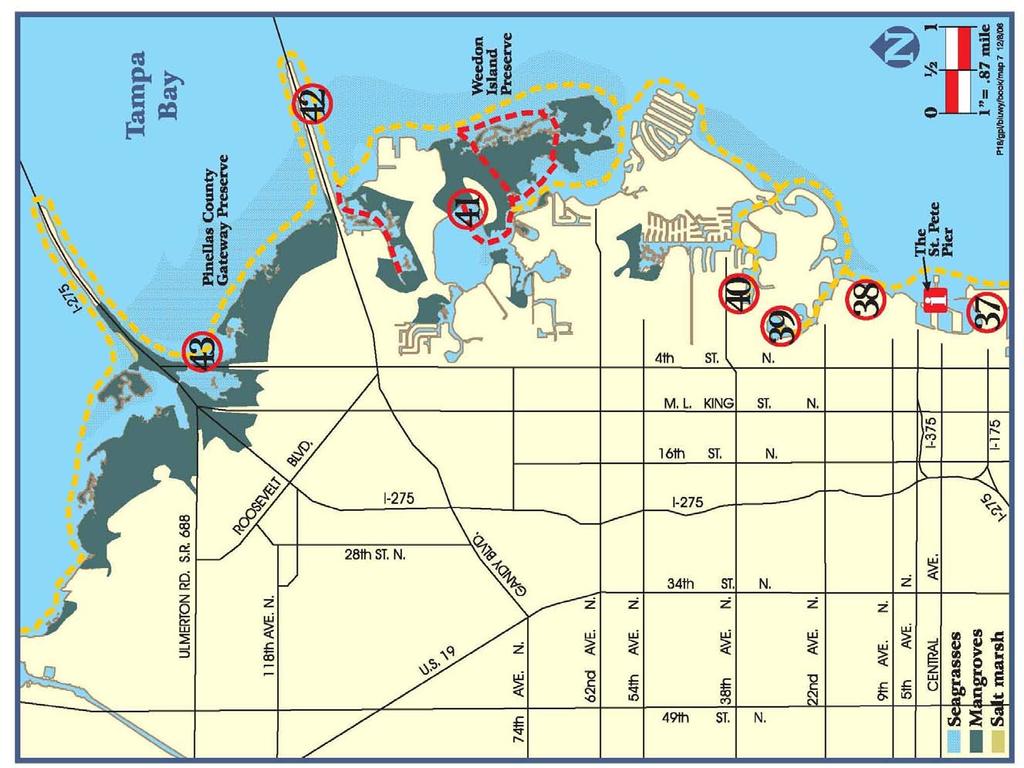
41 37. DEMEN S LANDING See Park description on page NORTH SHORE PARK See Park description on page COFFEE POT BAYOU PARK See Park description on page CRISP PARK See Park description on page WEEDON ISLAND PRESERVE 1800 Weedon Drive N.E., St. Petersburg This preserve, owned and operated by Pinellas County, contains approximately 3,100 acres of natural habitat, including mangrove swamps, intertidal flats and pine flatwood uplands. Home to many different species of wildlife and plants, wildlife and nature viewing is at its best here. Tortoises, shorebirds, dolphins, manatees, mangrove crabs, stingrays, jellyfish and jumping mullet are just a few among the many species of animals found among the Weedon Island ecosystem. On land, Weedon Island has an extensive network of boardwalks and trails throughout the various habitats, as well as an Interpretive Center where people can learn about the natural and cultural history and environment of the Preserve. Two marked canoe/kayak trails are available that lead through the groomed mangrove tunnels and into the shallow waters among the mangrove islands. The tunnels open into small, shallow lagoons in several places, offering excellent fishing opportunities. Combustion engines are prohibited throughout the island boundaries, allowing a very diverse natural ecosystem to thrive. Keep an eye out for manatees in the shallow waters around the island, especially near the power plant on the northern part of the island. The U.S. Fish and Wildlife Service has designated part of the surrounding area to the north of the power plant as a manatee sanctuary. Boating of any kind is restricted there, and watercraft are not allowed in the area between November 15 and March 31. Please observe regulatory signs. The mangrove tunnels through Weedon Island are very tidally influenced, and it is possible to become trapped in them during a receding tide. Mosquitoes can also be a problem within the tunnel system. The launching area offers a floating dock and a small, sandy beach to the left of the launch site. Parking is available during daylight hours only and only in designated parking areas. (727) For more information regarding the plant and animal life, please visit: envlands/el6000.html 36


42 42. GANDY BOULEVARD CAUSEWAY Gandy Boulevard, St. Petersburg This Causeway is under the management of Pinellas County and offers sandy beach areas for launching along both the northern and southern sides. There is also a bait shop and boat ramp access at the nearby Gandy Bridge marina, which charges a $5 fee for use. This launch offers direct access to the north Weedon Island marked trail. If launching from the south side of the Causeway, head south towards the power plant for possible manatee viewing, especially in the winter months. Please heed regulatory signs and avoid the access-restricted manatee sanctuary. Head west among the spoil islands and look out for numerous horseshoe crabs, snook, sting rays and a variety of shorebirds in the area. Mangrove tunnels are located at marker #3, where you can spot mangrove crabs along the prop roots on each side of you and above your head. If launching from the north side of the causeway, follow the coast along the Pinellas County Gateway Preserve. Here, there are wide areas of seagrass beds, encouraging the diverse ecosystem. Dolphins, manatees, and a variety of fish and shorebirds reside here. There are also a number of oyster bars in the area which can be exposed in times of low tide. Parking is undesignated and along the causeway. sandy beach surface and access to the Pinellas County Gateway Preserve. The protected waters close to the roadway are rich in seagrasses, fish and shorebirds. In those waters a bit further out, manatees and dolphins can often be seen. Paddle to the west along the shoreline and you will come to the St. Petersburg/Clearwater International Airport and the entrance to the northern end of the Cross Bayou Canal. Parking is undesignated along the causeway and launching is available wherever there is a break in the mangroves. Please do not disturb the mangroves or bird life TH STREET NORTH/GATEWAY PRESERVE 4 th St N/Howard Frankland Approach, St. Petersburg Under the management of the Florida Department of Transportation, launching is available along 4 th Street North in any of the breaks in the mangroves. Each break offers a 37
43 38 Map 8


44 MAP 8: GPS Coordinates for Highlighted Features Reachable from Launch Points 44. Allen s Creek Launch Site Myron A. Smith Bayview Park 46. Cooper's Bayou Park ' ' End of Cooper's Bayou ' ' 47. Safety Harbor Marina ' R.E. Olds Park ' Philippe Park ' ' 49. Mobbly Bayou Wilderness Preserve Entrance to Mobbly Bayou Boat Launch at Phillipe Park Pelicans at Safety Harbor 39 * Please see launch point descriptions for details.
45 44. ALLEN S CREEK US Hwy. 19, St. Petersburg The launching site for Allen s Creek is located on the south side of the parking lot at17900 US-19 N. The site is a sandy beach area, but is accessed by walking down a grassy slope that is steep in some places. Upstream near Belcher Road, Allen s Creek is surrounded by a Pinellas County Management Area, encompassing 35 acres of uplands and wetlands along the banks of the creek. This area is currently the target of a major restoration effort to improve wildlife habitat. Even so, the creek is currently home to a variety of shorebirds and fish. Alligators also roam the creek. The launch site also offers access to Upper Tampa Bay to the east, where paddlers can view both wildlife and the urban landscape from the water. 45. MYRON A. SMITH BAYVIEW PARK 3035 Gulf-to-Bay Boulevard, Clearwater Located immediately west of the north end of the Bayside Bridge, this City of Clearwater Park was designated for passive daytime recreational use. Amenities include limited parking, a small sand beach about 100 yards from the parking area, a drinking fountain, benches, trash cans and a ½ mile scenic walking trail with two shade shelters and many large oak trees. The area is tidally influenced and may be more difficult to access during low tide. From here, paddle east and north along the coastline, passing under the Bayside Bridge and the Courtney Campbell Causeway to enter Upper Tampa Bay for access to Safety Harbor and Oldsmar. Parking is available in Bayview Park during daylight hours only. City of Clearwater Parks & Recreation, telephone: (727) , press COOPER S BAYOU PARK 709 Bayshore Boulevard, Clearwater The City of Clearwater developed this park for passive recreation along the waterfront, with few amenities but many scenic views. Launching is available on the hard mud surfaces along the waterfront where there are breaks in the mangroves, in the north and south portions of the park. The sides of the bank are steep towards the north. Launching from the park puts you right in the middle of Cooper s Bayou. This area is a tidally influenced body of water that is lined with mangroves and rich in biodiversity. A number of fish inhabit the waters here and shorebirds thrive along the water s edge as well as several oyster beds along the waterfront. Egrets, hawks and stingrays have all been known to frequent the area. From here, paddle north along the coastline for easy access to downtown Safety Harbor and Upper Tampa Bay. Along the waterfront are vast expanses of seagrasses, so keep an eye out for manatees and dolphins in this area. South of this bayou is the Courtney Campbell Causeway. Paddle under the causeway and follow the shoreline to the west and south to access Allen s Creek. Amenities include parking, a designated canoe/kayak launch area, a drinking fountain, benches, trash cans and a misty shower. The Ream Wilson Clearwater East-West Trail also runs through the park. Clearwater Parks & Recreation: Telephone: (727) , press 7. 40
46 47. SAFETY HARBOR MUNICIPAL MARINA Bayshore Boulevard/Main Street, Safety Harbor Owned and operated by the City of Safety Harbor, this marina offers both boat ramp and a sand/rock launch access to Upper Tampa Bay and Safety Harbor. Located at the east end of Main Street in downtown Safety Harbor, this launching site is within a close distance to a number of restaurants, stores and the historic Safety Harbor Resort and Spa. In Upper Tampa Bay and Safety Harbor, keep an eye out for manatees and dolphins. Also, a wide variety of fish and shore birds inhabit this area as it is rich in seagrasses that sustain the wildlife population. Paddle north of the launch site and follow the coast to reach Philippe Park. From here, you can circumnavigate the harbor or cross the water to the Mobbly Bayou Wilderness Preserve. Overnight parking is available with a free pass from the Community Center. A post office is located within walking distance at 303 Main Street. Marina Telephone: (727) PHILIPPE PARK 2525 Philippe Parkway, Safety Harbor Pinellas County owns and operates this 122-acre park, shaded by large oaks and other hardwood trees. Offering direct access to Old Tampa Bay, Philippe Park has both sandy beach and boat ramp access to the water. An ancient Indian mound is located in the south of the park near the beach launching area. Across the water is the Mobbly Bayou Wilderness Preserve. This preserve is home to a number of 41 species of animals and plants and provides excellent wildlife viewing opportunities. In the Bay you can often find manatees and dolphins, and pelicans are almost always perched on the electricity towers crossing the Bay just south of the Park. Near the shore, keep an eye out for stingrays and jellyfish. Parking is available during daylight hours only within the park. The City of Oldsmar operates two parks on the other side of the Bay, one is passive, and the other (R.E. Olds) has restroom and water facilities and is available as a resting place. Look for the blue roof of the gazebo. Park Telephone: (727) MOBBLY BAYOU WILDERNESS PRESERVE 423 Lafayette Boulevard, Oldsmar Maintained by the City of Oldsmar, this Preserve offers two floating docks for launching and access to Mobbly Bayou and Safety Harbor. This preserve is home to a variety of animals, including fish, shorebirds, raccoons and rabbits. Manatees and dolphins are a common sight in the Bayou, with mangroves lining the waterfront of this Preserve. The park is still under development and future improvements are planned. Paddle along the canal and enter the Bay on the eastern-most part of Pinellas County. Follow the coastline to the south to skirt the Preserve, entering Safety Harbor after rounding the point. Here, you can circumnavigate the Harbor, or cross the water to reach Philippe Park or downtown Safety Harbor just a little to the south. Parking at the Preserve is available during daylight hours only. The surrounding waterways are very tidally influenced. Park Telephone: (813)


47 Anclote Key Lighthouse (Map 1) The Anclote Key Lighthouse was built in 1887, designed to mark the entrance into the Anclote River. The lighthouse was serviced by a series of keepers living on the island, until its automation by the US Coast Guard in Following its automation, vandalism caused the lighthouse to fall into disrepair, and it was decommissioned in The Lighthouse was re-lit in 2003 following a campaign by the Gulf Islands Alliance Citizen Support Organization and is maintained once again by a keeper living on the island. Spring Cavern near Howard Park (Map 1) This natural spring is located about 200 yards due north of the second bridge from the mainland on the Howard Park Causeway. If you plan to dive this sink, it is important to do so at high tide and to make sure that you have a diving flag signifying your position. There can be heavy traffic by waverunners in this area, especially on the weekends. Tarpon Springs Sponge Docks (Map 1) The Sponge Docks is the site of one of the leading natural sponge industries in the world. Here, all aspects of the sponge industry take place, including the harvesting of the sponges and weekly auctions to wholesalers. Located in the Sponge Capital of the World, these docks have created a lively tourism industry, being the focal point for over 100 shops and many restaurants, featuring some of the most authentic Greek cuisine in Florida. POINTS OF INTEREST 42 Belleview Biltmore (Map 3) Located in the Town of Belleair, this historic site has been operating as a hotel since 1897, serving such guests as the Studebakers, the DuPonts, the Vanderbilts, and Margaret Thatcher. Known as the White Queen of the Gulf, this hotel was once completely selfsufficient, with its own post office, police department and fire department. It is reputed to be the world s largest occupied wooden structure. The Biltmore was named to the National Registry of Historic Places in 1979 and boasts an Olympic sized swimming pool, 18-hole golf course and red clay tennis courts. John s Pass Village (Map 4) This quaint fishing village at the south end of Madeira Beach features a 1,100-foot long boardwalk, 100 retailers with unique shopping, cruise lines, a variety of restaurants, boat rentals, jet skiing, and parasailing and the local fishing fleet. This site is home to the legend of Pirate John LeVeque, who is believed to have buried his treasure on Madeira Beach in the 18 th Century. Upon returning for his treasure after a hurricane, LeVeque found that the beach had been washed away and a Pass was created between what is now Madeira Beach and Treasure Island. LeVeque stayed in the area, fishing and swimming the waters and searching for his treasure. John s Pass is named for LeVeque in honor of his discovery of the area and for the treasure he never found again.


48 The Don Cesar (Maps 4 & 5) Built in 1924 by Thomas Rowe, the Don Cesar fulfilled his dream to build a pink castle. The Don has hosted a number of rich and famous guests, including F. Scott Fitzgerald, Franklin D. Roosevelt and Al Capone. Facing financial troubles during the Depression, the New York Yankees signed a 3-year contract with the Don to house the players during spring training, bringing in substantial funds and an entourage of sports writers and editors, nearly filling the hotel to capacity and saving the Don from closure. In 1944, the US Army seized the hotel and used it as a convalescence center for troops wounded in the battlefield. The Army left in 1945, but the hotel was subsequently taken over by the Veteran s Administration and other government offices, before being vacated and falling into severe disrepair. The hotel was refurbished and re-opened in 1973, being named to the National Register of Historic Places in 1975, and continues to operate as a hotel to this day. North Beach (Map 5) In 2005, Stephen Leatherman (Dr. Beach) named North Beach in Fort DeSoto County Park America s Best Beach. Beaches are the number one recreational destination for Americans. This all natural and undeveloped beach offers vast stretches of white sand and natural vegetation. At high tide, the beach may become an island of its own, requiring a pleasant wade out to its pristine sand. The St. Petersburg Pier (Maps 6 & 7) The Pier has been a landmark in downtown St. Petersburg since Renovated as the Million Dollar Pier in 1926, and again in 1973 as the inverted pyramid that it is today, the Pier has stood for over a century as a gateway to St. Petersburg from the sea. Today, the Pier houses an aquarium, several restaurants and a number of specialty shops. Fishing is a popular pastime along the approach to the building, with rod rentals and bait for sale at the Pier bait house. Dolphin watching tours operate daily from the Pier on chartered boats. On the landside, downtown St. Petersburg with its large number of sports venues, hotels, retail shops and museums offers many diversions. 43
 464-4077. The Watch Line is an important tool used to identify area locations frequented by the manatee.")
, consuming 80-100 pounds of vegetation daily.")


49 SOME INTERESTING PLANTS AND ANIMALS IN THE AREA WEST INDIAN MANATEE Manatees can often be seen in the coastal waters surrounding Pinellas County. If you happen to spot a manatee, please contact the Pinellas County Manatee Watch Line at (727) The Watch Line is an important tool used to identify area locations frequented by the manatee. Manatees have an average length of 10 feet and weigh pounds. Manatees can be found living in freshwater, brackish or marine environments and are herbivorous (feeding on plant material), consuming pounds of vegetation daily. These gentle marine mammals are the source of the legendary mermaids of the sea. Today, the West Indian Manatee is classified as a Federally endangered species and is threatened by boat and barge traffic, flood control structures, loss of habitat, pollution, and carelessly thrown trash and fishing gear. As these mammals are protected, do not harass or feed them. AMERICAN OYSTERCATCHER Around Pinellas County, you will encounter a number of oyster beds. The beds are found where currents can carry particles of food to the oysters. When oyster larvae are produced, it is carried in the current and attaches to another oyster to grow. This creates clusters of oysters, or the beds that you see in the water. The American Oystercatcher is a shorebird which preys upon the oyster beds, along with crabs and starfish. 44 MANGROVES There are three species of mangroves common to Florida that can be seen along the Pinellas County coastline. Red mangroves grow along the shore and are often referred to as walking trees because their prop roots give the appearance of walking. Behind these, grow the black mangroves, which are identifiable by their numerous finger-like projections called pneumatophores. These pneumatophores protrude from the soil and help bring oxygen to the tree s roots. The white mangrove has light yellow-green leaves which are oval and have two small glands at the base of each leaf blade. Mangroves are essential to the environment of Pinellas County, providing organic matter to feed fish life and encourage a diverse aquatic habitat. Mangroves also filter human pollution and protect the mainland of Pinellas County from flooding associated with storm surge. BOTTLENOSE DOLPHINS This type of dolphin is common to the waters surrounding Pinellas County and resides in groups called communities which tend to remain within the same general location for a number of generations. Dolphin feed on a variety of fish, including mullet, pinfish and pigfish. ALLIGATORS Alligators are present in virtually every freshwater body of water in the region. These prehistoric reptiles are normally afraid of humans and will keep their distance. It is illegal to feed alligators because it causes them to lose their


. HERON The Great Blue Heron in Florida comes in two colors; gray and white.")

50 natural fear of humans and, as a result, they may begin to associate humans with food. Be careful during the month of May, which is peak mating season for alligators, as they may become territorial. Alligators can be dangerous; do not approach or harass them. STINGRAYS This animal is common in the shallow waters around the Pinellas County coastline. Stingrays feed from the bottom of the sea floor and can be seen floating, or flying, through the water. Stingrays are not aggressive, but will sting you with their tail if stepped on. Pinellas County advises those wading in the coastal waters to do the Stingray Shuffle, shuffling your feet and kicking up sand as you walk. Stingrays rest in the sand and can be difficult to spot if they have buried themselves. FISH There are a great number of species native to the coastal areas of Pinellas County. One species that you will often find close to the coast and in mangrove areas is the mullet. This fish is recognizable because it often takes flying leaps out of the water. In those shallow areas around Weedon Island and just outside of Boca Ciega Millennium Park, it seems that there is almost always a mullet jumping near you. Other varieties of fish to look for include striper, snook, and amberjack (in deeper water). HERON The Great Blue Heron in Florida comes in two colors; gray and white. While they are the same 45 White Morph Heron species of bird, the white morph colored heron is distinguishable by a solid white body, yellow beak and pale legs. The gray colored heron has a gray body, a white crown stripe and a black plume extending from behind the eye to behind the neck. Herons in general have a large body, an S shaped neck and long legs. Herons gather in shallow, coastal waters where fish are abundant. It is not uncommon to find these birds in large groups in shallow waters near mangrove areas fishing for a meal. Herons are also known for incorporating other animals into their diet, including mice. EGRETS Snowy White Egret Great Blue Heron The Great Egret is also known as a large, white heron. Common to the coastal waters of Pinellas County, these birds are similar to the white morph Great Blue heron, but slightly smaller in size. The egret has a white body with long black legs and feet. Its neck is S shaped and its bill is long and yellow. The snowy white egret, distinguished by its yellow feet, is another bird in the egret family common to the area. The Great Egret sustains itself mainly on fish and is the symbol of the National Audubon Society, one of the oldest environmental organizations in North America. BROWN PELICAN This variety of pelican is the only dark colored pelican out of seven different types, and also the only one that dives from the air to catch its food in the water. The Brown Pelican is found on coastlines throughout Pinellas


51 County. In fact, there are a couple of pelican islands located on the eastern side of the County, one south of Coquina Key and the other in Coffee Pot Bayou. The Brown Pelican is listed as a Species of Special Concern in Florida, as shooting the birds for feathers and to protect the fish populations became commonplace in the early 20 th century. Deaths attributed to pesticide poisoning, especially by DDT, was also a main contributor. Over the last few decades, however, the population numbers have begun to climb again and the brown pelican is gradually recovering. WOODSTORK This bird is large, long-legged wader with a long neck and a large, slightly curved bill. There are no feathers on the woodstork s head or neck, but it has plumed white feathers on its body and black feathers on the bottoms of its wings. This stork flies with its neck extended and feeds mainly off of coastal fish. This bird is listed as Endangered, because of its mangrove habitat decreasing due to wetland development. ROSEATE SPOONBIL This bird is listed as a Species of Special Concern in the State of Florida. Locally, they are commonly found in coastal mangrove or spoil islands. It is the only spoonbill species in the Western Hemisphere and the only pink bird to breed in Florida. This bird is vulnerable to human disruption of its nesting colonies and to the alteration of its feeding habitats. GOPHER TORTOISE These herbivorous reptiles are classified as a Species of Special Concern by the State of Florida. The gopher tortoise is common in many upland habitats in Florida, including scrub, pine flatwoods and dunes along the beach. The tortoise requires sandy soil for burrowing into the ground, small plants to eat and an open tree canopy to allow sunlight through. The burrow provides the tortoise with protection from predators, extreme heat conditions and stormy weather. The main threats to gopher tortoises today are habitat destruction, invasive species and an upper respiratory disease which has been spreading throughout the tortoise population. SEAGRASSES Seagrasses are submerged aquatic vegetation and an integral part of our local marine environment. A single acre of seagrass can produce 10 tons of leaves per year, which provide food, habitat and breeding areas for fish, shorebirds and aquatic mammals. These beds also provide protection to juvenile fish and dampen the effects of wave action on the coastline. When in seagrass areas use caution to not damage or otherwise harm this vegetation. The greatest threats to seagrasses come from pollution and propeller scarring. In Pinellas County, special seagrass protection areas exist around both Fort DeSoto Park and Weedon Island. St. Joseph s Harbor, between Tarpon Springs and Dunedin, is also heavily vegetated with seagrasses. Special precautions should be taken in these areas so as to not damage this vital habitat. 46
THE PINELLAS COUNTY PLANNING DEPARTMENT
 Guide to Pinellas County Blueways Prepared by THE PINELLAS COUNTY PLANNING DEPARTMENT December, 2006 Revised April, 2010 P inellas County has miles of beautiful shoreline, providing paddlers with a variety
Appendix E. Inventory of Pinellas County Blueways Launch Sites. Recreation, Open Space & Culture Element E-1
 Appendix E Inventory of Pinellas County Blueways Launch Sites Recreation, Open Space & Culture Element E-1 1 2 3 4 5 6 7 8 APPENDI E John Chestnut Park 2200 East Lake Rd., Palm Harbor Al Anderson Park
Pinellas County Environmental Lands
 Pinellas County Environmental Lands In addition to traditional parks and recreation facilities, Pinellas County owns and manages a system of environmental lands that provides specialized resource-based
Florida Department of Environmental Protection Division of Recreation and Parks
 Florida Department of Environmental Protection Division of Recreation and Parks Land Honeymoon Island State Park Introduction Honeymoon Island State Park is a 2,810.16-acre public outdoor recreation and
APPENDIX D: Open Water Strata and Land Site Locations and Descriptions
 APPENDIX D: Open Water Strata and Land Site Locations and Descriptions Open Water Strata: Marine Waters W1 St. Joseph Sound W3 Clearwater Harbor south W5 Long Bayou/Cross Bayou W7 Boca Ciega Bay central
WEST SECTION TRAIL SITES as of Mon October
 WEST SECTION TRAIL SITES as of Mon October 9 2017 Partial Site is open but some hiking trails/facilities may be closed Closed Site is closed until further notice Open Site is open Unknown We have no information
Camping (Primitive) Camping (RV) Electrical Potable Water Grill Established Fire Pit Picnic Table
 Camping (RV) Electrical Potable Water Grill Established Fire Pit Picnic Table") Alden - 9th Road River Mile 777 Map: 38.20833, -98.32031 Managing Agency: Kansas Department of Wildlife, Parks & Tourism Nearest Community: Alden, Rice County Kansas Developed Amenities Provided Parking
Alden - 9th Road River Mile 777 Map: 38.20833, -98.32031 Managing Agency: Kansas Department of Wildlife, Parks & Tourism Nearest Community: Alden, Rice County Kansas Developed Amenities Provided Parking
Welcome to Marco Island
 Marco Island is located in Southwest Florida, on the Gulf of Mexico, 178 miles south of Tampa,16 miles south of Naples, and 104 miles due west of Miami. Marco is the northern most and largest of the famous
VOLUME II APPENDIX F DETAILED PHYSICAL DESCRIPTION OF PROJECT RESERVOIRS AND LANDS
 VOLUME II APPENDIX F DETAILED PHYSICAL DESCRIPTION OF PROJECT RESERVOIRS AND LANDS THE CENTRAL NEBRASKA PUBLIC POWER AND IRRIGATION DISTRICT FERC PROJECT NO. 1417 PHYSICAL DESCRIPTION OF PROJECT LANDS
Conservation Lands. Conservation Lands Advisory Committee October 19, 2005
 Conservation Lands Advisory Committee October 19, 2005 Roland DeBlois Chief of Environmental Planning & Code Enforcement Community Development Department Beth Powell Conservation Lands Manager Parks Division
Toll Rates for Florida Turnpike System and Florida Department of Transportation (FDOT) Toll Facilities. West Central Florida
 Toll Facilities. West Central Florida") Toll Rates for Florida Turnpike System and Florida Department of Transportation (FDOT) Toll Facilities West Central Florida Effective: October 29, 20 Veterans (SR 589) Hillsborough County Veterans SunPass
Toll Rates for Florida Turnpike System and Florida Department of Transportation (FDOT) Toll Facilities West Central Florida Effective: October 29, 20 Veterans (SR 589) Hillsborough County Veterans SunPass
Where the Sidewalk [Literally] Ends
![Where the Sidewalk [Literally] Ends](/thumbs/74/71371935.jpg "Where the Sidewalk [Literally] Ends") Where the Sidewalk [Literally] Ends by Edie Creter May 1, 2017, another perfect biking day. In the spring of 2013 I wrote a pictorial Breeze article (Where the Sidewalk Begins... ) after my first visit
Where the Sidewalk [Literally] Ends by Edie Creter May 1, 2017, another perfect biking day. In the spring of 2013 I wrote a pictorial Breeze article (Where the Sidewalk Begins... ) after my first visit
A +/- 16 acre waterfront property for sale on Florida s Gulf Coast.
 A +/- 16 acre waterfront property for sale on Florida s Gulf Coast www.landsolutions.net PROJECT SUMMARY Marina Preserve is a ±16 acre waterfront property for sale on Florida s Gulf Coast. The development
San Francisco Bay Area Water Trail Site Description for. Suisun City Marina. Launch ramps and docks Suisun Channel Parking Lot
 1 San Francisco Bay Area Water Trail Site Description for Suisun City Marina Location, Ownership, and Management: Suisun City Marina is located on Kellogg St., approimately a half mile from Suisun City's
Guide to Local Activities
 Guide to Local Activities We welcome you to Naples and the Vineyards! Naples is a wonderful place to visit and live. Our coast has everything you can possibly want from pristine beaches and island getaways
STORNETTA BROTHERS COASTAL RANCH
 STORNETTA BROTHERS COASTAL RANCH Location: Surrounding Point Arena Lighthouse and immediately south of Manchester State Park Mendocino Co., CA Acres: 1,860 Resources: Over two miles of Pacific Ocean coastline
NORTH MARINA AREA MIXED USE REDEVELOPMENT Clearwater, Florida
 REDEVELOPMENT SITE Garden Trail Apartments (76 Units) Under Construction Property Information Location and Size: 802 N. Fort Harrison Avenue 37,171 SF land 804 N. Osceola Avenue 5,950 SF land 805 N. Fort
Stone Harbor Municipal Public Access Plan. in accordance with N.J.A.C. 7:7E
 Stone Harbor Municipal Public Access Plan in accordance with N.J.A.C. 7:7E December 2011 Stone Harbor Municipal Public Access Plan EXECUTIVE SUMMARY In the spring of 2011, the New Jersey Department of
Appendix G. Pinellas County Archaeological Resources Database. Recreation, Open Space & Culture Element G-1
 Appendix G Pinellas County Archaeological Resources Database Recreation, Open Space & Culture Element G-1 Pinellas County Archaeological s Database # Name NR E PE ND NE Level Culture Type TWN/RNG/S Jurisdiction
NORTH MARINA AREA MIXED USE REDEVELOPMENT SITE Clearwater, Florida
 REDEVELOPMENT SITE Property Information Location and Size: 802 N. Fort Harrison Avenue 37,171 sf land 804 N. Osceola Avenue 5,950 sf land 805 N. Fort Harrison Avenue 7,000 sf land / 2,532 sf bldg. Access:
Acquisition in fee simple of approximately one-half acre of property on the shore of Spring Lake to expand the Lakeside Beach Park.
 Lakeside Beach TF00-136 $122,550.00 in fee simple of approximately one-half acre of property on the shore of Spring Lake to exp the Lakeside Beach. 2000 River Ravines TF00-150 $910,000.00 in fee simple
INVESTMENT SUMMARY. Jason Donald. Patrick Berman. Todd Tolbert. Cushman & Wakefield of Florida, LLC. Irreplaceable waterfront location.
 INVESTMENT SUMMARY INVESTMENT SUMMARY Irreplaceable waterfront location. Unique mixed-use property: retail, restaurants and office space with a 325-space parking structure. Stable income stream, strong
Camping and Cabins Guide. Florida State Parks. FloridaStateParks.org #FLStateParks
 Camping and Cabins Guide Florida State Parks FloridaStateParks.org #FLStateParks Welcome When the setting sun paints the evening sky, where will you make your bed? Florida s state parks offer you a variety
CHAPTER 4 EXISTING PARKS AND RECREATION FACILITIES INVENTORY
 CHAPTER 4 EXISTING PARKS AND RECREATION FACILITIES INVENTORY Existing park and recreation sites and facilities provide the basis upon which to build a park and recreation plan for the city. This inventory
Lake Wissota Access Locations within the LaFayette Township. By Chad Martin
 Lake Wissota Access Locations within the LaFayette Township By Chad Martin Anson/ Wissota Access Point # 1 Road: 195 th St. Associated Fire Numbers: 13294 Defining Characteristics: Forested from road
TENKILLER STATE PARK -An Overview-
 TENKILLER STATE PARK -An Overview- - 0 - TENKILLER STATE PARK Region: Northeast (Green Country) Cherokee & Sequoyah Counties CONTENTS General Information. 2 Addresses Driving Directions Phone Numbers Email
ROBERTS CREEK PROVINCIAL PARK MASTER PLAN. November, 1981
 Ministry of Lands, Parks and Housing Parks and Outdoor Recreation Division Park Operations Branch North Vancouver, B. C. ROBERTS CREEK PROVINCIAL PARK MASTER PLAN November, 1981 Mr. G. Trachuk Director
Cat Island Chain Background & Access Guide
 Cat Chain Background & Access Guide Brown County Port & Resource Recovery Department 2561 S. Broadway, Green Bay, WI 54304 (920) 492-4950 www.portofgreenbay.com January 2018 1 Restoration of the Cat Chain
1. Overview of Atlantic Highlands and Its Waterfront
 Atlantic Highlands 1. Overview of Atlantic Highlands and Its Waterfront Atlantic Highlands: Satellite Photo by USGS 1.1. Geographical Overview The Borough of Atlantic Highlands is on Sandy Hook Bay. It
A Vision for South Skunk River and Chichaqua Bottoms Greenbelt
 A Vision for South Skunk River and Chichaqua Bottoms Greenbelt Photo: Jim Pease Chichaqua Bottoms Booklet 7 of 8 Greater Des Moines Water Trails and Greenways 1 2016 Table of Contents Booklet 1: Water
Header i
 Header i 048285014.10 Header Sub Title Body Text here. Body text here. Body text here. Section 1... 1 Executive Summary... 1 Opportunities and Constraints... 3 Overall Opportunities and Constraints Map
Recent Dock Permits. Ameri Tech Prop Mngmt Kilgore RM Windward Passage Clearwater Approved 01/19/2018
 Recent Dock Permits Friday 26 January 2018 Last Name Aka Name Permi Permit # Num Street City Status Close out ALTWT2 LLC P 47519-17 1310 Riverside Ave Tarpon Springs Approved 01/08/2018 Ameri Tech Prop
Geographic Response Plan Map: EFL-40 ]^4011. ! Manatee [v NERR. National Park. Naval Facility. Piping Plover. Power Plant. Recreational Fishing
![Geographic Response Plan Map: EFL-40 ]^4011. ! Manatee [v NERR. National Park. Naval Facility. Piping Plover. Power Plant. Recreational Fishing](/thumbs/91/105050028.jpg "Geographic Response Plan Map: EFL-40 ]^4011. ! Manatee [v NERR. National Park. Naval Facility. Piping Plover. Power Plant. Recreational Fishing") 29 22'30"N 81 7'30"W!E(! EFL40-01 Basin Bulow Creek State Park Addison Blockhouse Historic State Park NRC - Ormond Beach Warehouse Equipment Site (ID JAX-E8) River Basin k k Marsh Aquatic Preserve!S( 200
29 22'30"N 81 7'30"W!E(! EFL40-01 Basin Bulow Creek State Park Addison Blockhouse Historic State Park NRC - Ormond Beach Warehouse Equipment Site (ID JAX-E8) River Basin k k Marsh Aquatic Preserve!S( 200
10.7 Acre Oceanfront North Rendezvous Island
 10.7 Acre Oceanfront North Rendezvous Island Jamie Zroback jamie@landquest.com 1 (604) 483-1605 Jason Zroback jason@landquest.com 1 (604) 414-5577 The Source for Oceanfront, Lakefront, Islands, Ranches,
Unit 1 Lesson 1: Introduction to the Dry Tortugas and Sustainable Seas Expedition
 Unit 1 Lesson 1: Introduction to the Dry Tortugas and Sustainable Seas Expedition Lesson Objectives: Introduce students to the historical, geographic, and ecological importance of the Dry Tortugas. Introduce
MONTAGUE HARBOUR MARINE PROVINCIAL PARK
 MONTAGUE HARBOUR MARINE PROVINCIAL PARK PURPOSE STATEMENT AND ZONING PLAN March 2003 1 MONTAGUE HARBOUR MARINE PROVINCIAL PARK Purpose Statement and Zoning Plan Primary Role The primary role of Montague
Staff Report on Brevard County Area Projects (See pages 32-60) Staff will present a report on District Projects in the Brevard County area.
 Staff will present a report on District Projects in the Brevard County area.") Call to Order - Chair Netts will call the meeting to order. Pledge of Allegiance - Commissioner Sansom will lead the Pledge of Allegiance. Roll Call - Secretary Gernert will call the roll. Additions or
Call to Order - Chair Netts will call the meeting to order. Pledge of Allegiance - Commissioner Sansom will lead the Pledge of Allegiance. Roll Call - Secretary Gernert will call the roll. Additions or
±1.55 ACRES OF WATERFRONT MF LAND
 A p ol l o Beac h Bl vd Sunse ir t Ba yc ±1.55 ACRES OF WATERFRONT MF LAND EXCLUSIVE LISTING EXCESS LAND AT BELLA SOL WATERFRONT VILLAS APOLLO BEACH, FLORIDA OPPORTUNITY ±1.55 acres of undeveloped land
Discover Naples only. Discover Naples only. private island club
 Discover Naples only Discover Naples only private island club private island club Pelican Isle Yacht Club is conveniently situated in an exclusive Southwest Florida location just five minutes from the
Pre-Tournament Guide
 Clearwater, Florida USA 24-30 July 2017 Pre-Tournament Guide Table of Contents Table of Contents 2 Welcome Letters 3 About The Venue 5 Hotel Partners 7 Local Attractions 12 Tournament Partners July 7,
Bratt ") 4. % F l o r i d a D e s i g n a t e d P a d d l i n g T r a i l s ") 164 «97 ") 99. Barrineau Park. M a p 1. M a p 2.
 4. % F l o r i d a D e s i g n a t e d P a d d l i n g T r a i l s ) 164 «97 ) 99. Barrineau Park. M a p 1. M a p 2.") F l o r i d a D e s i g n a t e d P a d d l i n g T r a i l s Bratt ") 4 Bluff Springs «4 Jay ") P e r d i d o R i v e r P e r d i d o CR R99A i v Walnut e r Hill ") 164 ") 97A «89 «97 ") 197 Barrineau
F l o r i d a D e s i g n a t e d P a d d l i n g T r a i l s Bratt ") 4 Bluff Springs «4 Jay ") P e r d i d o R i v e r P e r d i d o CR R99A i v Walnut e r Hill ") 164 ") 97A «89 «97 ") 197 Barrineau
THE ISLANDS PROVINCIAL PARK
 THE ISLANDS PROVINCIAL PARK Situated at the mouth of the Roseway River on Nova Scotia s scenic South Shore, The Islands is located across the harbour from the historic town of Shelburne. The park s picturesque
CHAPTER 4 -- THE LAND USE PLAN: DESCRIPTIONS AND POLICIES FOR THIRTEEN PLANNING AREAS
 CHAPTER 4 -- THE LAND USE PLAN: DESCRIPTIONS AND POLICIES FOR THIRTEEN PLANNING AREAS NORTH CENTRAL CAC PLANNING AREA 4.4 FORT BRAGG CITY LIMIT TO HARE CREEK PLANNING AREA (Includes Noyo) The Noyo community
City of Oak Harbor Parks & Descriptions
 City of Oak Harbor Parks & Descriptions North West Section Koetje Park - NE 7 th Avenue (3.5 acres) Neighborhood and Community Park with playgrounds on one tot lot, one soccer/practice field, picnic tables,
Recreation. the refreshment of body and mind...
 Recreation the refreshment of body and mind......that will enhance the quality of life for the diverse population of Hernando County - by strengthening communities, responding to community challenges,
BROUGHTON ARCHIPELAGO PROVINCIAL PARK
 BROUGHTON ARCHIPELAGO PROVINCIAL PARK PURPOSE STATEMENT AND ZONING PLAN March 2003 BROUGHTON ARCHIPELAGO PROVINCIAL PARK Purpose Statement and Zoning Plan Primary Role The primary role is to contribute
I* I9 ². F l o r i d a C i r c u m n a v i g a t i o n a l S a l t w a t e r P a d d l i n g T r a i l S e g m e n t 1 5
 M M 1 0 4-8 9 F l o r i d a C i r c u m n a v i g a t i o n a l S a l t w a t e r P a d d l i n g T r a i l S e g m e n t 1 5 F l o r i d a K e y s O v e r s e a s P a d d l i n g T r a i l M M 7 1-5 9
Androscoggin River Trail Access Sites. North Woods. 168 miles from its source at Lake Umbagog to Merrymeeting Bay
 Androscoggin River Trail Access Sites North Woods 168 miles from its source at Lake Umbagog to Merrymeeting Bay Trail Under Construction More than 40 Public Access Sites Available Androscoggin River Watershed
SAXON HARBOR REDEVELOPMENT SURVEY
 SAXON HARBOR REDEVELOPMENT SURVEY SEPTEMBER, 2016 1,173 RESPONSES 1 BACKGROUND 1. WHAT TYPES OF ACTIVITIES DO YOU ENGAGE IN AT SAXON HARBOR Sightseeing Swimming Picnicing Fishing Camping Photography Motorized
HARBOR INFRASTRUCTURE INVENTORIES Erie Harbor, PA
 HARBOR INFRASTRUCTURE INVENTORIES Erie Harbor, PA Harbor Location: Erie Harbor is located on the southern shore of Lake Erie in the City of Erie, PA about 98 Miles southwest of Buffalo. Authority: River
Florida Keys Challenge
 Florida Keys Challenge January 9-15, 2017 Start: Curry Hammock State Park End: Zachary Taylor State Park in Key West Total Distance: 65 miles Registration Deadline: December 26, 2016 Trip Fee: $800. Includes
Virginian Atlantic (Ecoregion 8)
") Virginian Atlantic (Ecoregion 8) Background The Virginian Atlantic Ecoregion extends from the south side of Cape Cod to Cape Hatteras in North Carolina. The waters of the ecoregion are a mix of cold and
Virginian Atlantic (Ecoregion 8) Background The Virginian Atlantic Ecoregion extends from the south side of Cape Cod to Cape Hatteras in North Carolina. The waters of the ecoregion are a mix of cold and
CHAPTER 4 -- THE LAND USE PLAN: DESCRIPTIONS AND POLICIES FOR THIRTEEN PLANNING AREAS
 CHAPTER 4 -- THE LAND USE PLAN: DESCRIPTIONS AND POLICIES FOR THIRTEEN PLANNING AREAS SOUTH COAST CAC PLANNING AREA 4.10 NAVARRO RIVER TO MALLO PASS CREEK PLANNING AREA (Includes Greenwood/Elk) This planning
ANCLOTE COASTAL TRAIL ALTERNATIVES ANALYSIS STUDY
 ANCLOTE COASTAL TRAIL ALTERNATIVES ANALYSIS STUDY PASCO COUNTY MPO JULY 2015 PROJECT OVERVIEW... INTRODUCTION EXECUTIVE SUMMARY CONTEXT... TAMPA BAY AREA, PINELLAS, & PASCO COUNTY S MULTI-USE TRAIL PLANS
Walk-On Waterfront Executive Home Qualicum Beach, BC
 Walk-On Waterfront Executive Home Qualicum Beach, BC Jamie Zroback jamie@landquest.com 1 (604) 483-1605 Jason Zroback jason@landquest.com 1 (604) 414-5577 Marketing British Columbia to the World The Source
St Petersburg-Clearwater Airport is on Roosevelt Blvd. at the southern end of the Bayside Bridge on SR 686
 Date: Sunday, March 2 nd 2014 Arrival Day Day Coordinator: Darlene Kalada HP: 727 531 4934 CP: 727 744 4965 Guests Arrive 8 guests arrive Allegiant Air Clearwater-St Petersburg International Airport (PIE)
Proposal to Redevelop Lower Kananaskis River-Barrier Lake. Bow Valley Provincial Park. Frequently Asked Questions
 Proposal to Redevelop Lower Kananaskis River-Barrier Lake Bow Valley Provincial Park Frequently Asked Questions What is being proposed? What are the details of the proposal? Where is the project area located?
IOWA ORNITHOLOGISTS' UNION - Birding Sites in Dallas County
 IOWA ORNITHOLOGISTS' UNION - Birding Sites in Dallas County Printed on 7/19/2018 Beaver Bottoms Wetland (restricted) (Important Bird Area) GPS Coordinates:, Ownership: Private (see directions for access)
ISLAND. FOR SALE Spanish Lookout Caye -186 Acre Island
 FOR SALE Spanish Lookout Caye -186 Acre Island ISLAND 186 Acre Private Island - Spanish Lookout Caye - just off Cruise Ship Mooring 8.5 Miles Southeast of Belize City, Spanish Lookout Caye Belize Spanish
Two Lots with Fixer-Upper Cabin & Drilled Well
 Two Lots with Fixer-Upper Cabin & Drilled Well Jason Zroback jason@landquest.com 1 (604) 414-5577 Jamie Zroback jamie@landquest.com 1 (604) 483-1605 Marketing British Columbia to the World The Source for
proof Northwest District
 1 Northwest District The Northwest Florida Water Management District is the most rural of all five water management districts. From just east of Tallahassee west to the Florida/Alabama line, and from the
Watchorn Provincial Park. Management Plan
 Watchorn Provincial Park Management Plan 2 Watchorn Provincial Park Table of Contents 1. Introduction... 3 2. Park History... 3 3. Park Attributes... 3 3.1 Natural... 4 3.2 Recreational... 4 3.3 Additional
LAGUNA ISLES DEVELOPMENT
 DEVELOPMENT FOR SALE LAGUNA ISLES DEVELOPMENT State Highway 361 South of Downtown Port Aransas, Texas 44.77 ACRES MIXED-USE DEVELOPMENT + 300 planned SF lots, most with bay or golf course frontage and
KETTLE CREEK CONSERVATION AUTHORITY TRAIL GUIDE.
 KETTLE CREEK CONSERVATION AUTHORITY TRAIL GUIDE www.kettlecreekconservation.on.ca EXPLORE OUR TRAILS HIKE OUR TRAILS Kettle Creek Conservation Authority (KCCA) proudly supports and promotes an active lifestyle
Things To Do, Places to Go
 Food Stores, etc: Things To Do, Places to Go Publix 4791 Estero Boulevard. It has a good selection, similar prices as off island, handy for beer and wine watch for specials. Topps - at Tropical Shores
Chapter eight. Parks and Recreation. Introduction. Crystal Lake Park District
 Chapter eight Parks and Recreation Introduction One of the indicators of quality of life in a city is the parks and recreation system. The City of Crystal Lake is fortunate to have an excellent parks and
Preliminary Social Program Schedule
 SOA 33 RD ANNUAL MEETING JULY 27-30, 2016 NAPLES GRANDE BEACH RESORT, NAPLES, FL Preliminary Social Program Schedule WEDNESDAY, JULY 27 12:00 pm 5:00 pm Meeting Registration 12:00 pm 5:00 pm Exhibit Setup
Proposal to Redevelop Lower Kananaskis River-Barrier Lake. Bow Valley Provincial Park
 Frequently Asked Questions Proposal to Redevelop Lower Kananaskis River-Barrier Lake Bow Valley Provincial Park Frequently Asked Questions What has been decided? What are the details of the plan? What
Two Lots with Drilled Well Savary Island, BC
 Two Lots with Drilled Well Savary Island, BC Jason Zroback jason@landquest.com 1 (604) 414-5577 Jamie Zroback jamie@landquest.com 1 (604) 483-1605 Marketing British Columbia to the World The Source for
Flow Stand Up Paddle Board Parkway Plan Analysis
 Regional Parks Department Jeffrey R. Leatherman, Director County of Sacramento Divisions Administration Golf Leisure Services Maintenance Rangers Therapeutic Recreation Services Flow Stand Up Paddle Board
Friday, Day One. Saturday, Day Two Travel the Inside Passage thru Canada (no Passport required) Sunday, Day Three
 Sunday, Day Three") 2015 : 15 Day Glacier & Wildlife Tour (Easily modified to 12 Days with return by Air) Tour : 1395 Number Travel Arrangements: US$4,100.00 per person, based on two people traveling together. Senior rate
2015 : 15 Day Glacier & Wildlife Tour (Easily modified to 12 Days with return by Air) Tour : 1395 Number Travel Arrangements: US$4,100.00 per person, based on two people traveling together. Senior rate
DRIVING TOUR OF PICKETT COUNTY TN THROUGH PHOTOS Traveling east on Hwy 111 starting at the Overton/Pickett County Line
 DRIVING TOUR OF PICKETT COUNTY TN THROUGH PHOTOS Traveling east on Hwy 111 starting at the Overton/Pickett County Line Welcome Sign as one enters County County Line Flea Market and Auction Historic Church
Hatchet and Weogufka Creeks Treasures of Coosa County. Roger Vines County Extension Coordinator
 Hatchet and Weogufka Creeks Treasures of Coosa County Roger Vines County Extension Coordinator Overview Coosa County The Heart of Alabama Very rural county with an abundance of natural resources forestland,
City of Haslett. City of East Lansing. City of East Lansing
 Central Park North (Nancy L. Moore Park) Lake Park North Expansion White Park Expansion #2 White Park Expansion #1 County East East Haslett East East TF87-212 Acquisition $90,000.00 Park. TF08-138 Acquisition
NORTH HEMPSTEAD BEACH PARK MASTER PLAN
 NORTH HEMPSTEAD BEACH PARK MASTER PLAN COMMUNITY DESIGN CHARRETTE Supervisor Judi Bosworth Viviana L. Russell Peter J. Zuckerman Angelo P. Ferrara Anna M. Kaplan Lee R. Seeman Dina M. De Giorgio VISIONING
The Falls: A Visitor & Interpretive Center for the Upper Lock
 The Falls: A Visitor & Interpretive Center for the Upper Lock Image courtesy of Northern Spark Surface by Aaron Dysart Illuminate the Lock is a program of Mississippi Park Connection The Falls Initiative
Silver Lake Park An Environmental Jewel for the Citizens of Prince William County
 Silver Lake Park An Environmental Jewel for the Citizens of Prince William County The Prince William Park Authority Mission Statement states: The Prince William County Park Authority will create quality
EXPLORE LOWER ALABAMA
 EXPLORE LOWER ALABAMA Ballard Sweat Sales Team Leader, Licensed in AL & FL 251.747.5930 mobile 251.948.1260 office ballard@gulfshorespropertysearch.com SEARCH GulfShoresPropertySearch.com GULF SHORES BON
Welcome to Seabrook Island. Seabrook Yesterday. And Today. The Horizon Plan
 Welcome to Seabrook Island There are few places left where the outside world rarely intrudes. You ve just found one of them. Only minutes from Charleston, SC, Seabrook Island s 2,200 acres stands as a
Everett Riverwalk Life style explore
 Life style explore Project Overview The 217-acre Everett Riverfront redevelopment is visible from I-5 with traffic counts charted at 170,000+ vehicles per day with direct freeway access from 4-way interchange.
Sasagiu Rapids Provincial Park. Draft Management Plan
 Sasagiu Rapids Provincial Park Draft Management Plan 2 Sasagiu Rapids Provincial Park Table of Contents 1. Introduction... 3 2. Background and Park Attributes... 3 2.1 Park History.... 3 2.2 Natural Features...
Keansburg: Satellite Photo by USGS. Township of Middletown, and the western tip of Keansburg is adjacent to the Borough of
 Keansburg 1. Overview of Keansburg and Its Waterfront Keansburg: Satellite Photo by USGS 1.1 Geographical Overview The Borough of Keansburg is one of nine communities that comprise the Bayshore Region
THOMAS A. SWIFT METROPARK Introductions History Present Conditions Future Development Plans Implementation Strategies Statistics
 THOMAS A. SWIFT METROPARK Introductions History Present Conditions Future Development Plans Implementation Strategies Statistics Introduction As an open meadow park positioned along the Mahoning River,
Corabelle Park. Inventory. Future Development
 Corabelle Park Size: Approximately 4 acres Site Description: Corabelle Park is a relatively new park within the Murray County Park System. It is located on the south side of Corabelle Lake just off gravel
WATER PETALUMA TRAIL WATER WAYS PROJECT PORTFOLIO. petalumawaterways.org OVERVIEW
 WATER TRAIL PROJECT PORTFOLIO OVERVIEW Thirteen miles upstream of San Pablo Bay, Petaluma is the northern point on the San Francisco Bay Water Trail, a network of access points throughout the region. Most
2009 RIVER TOWN OF THE YEAR AWARD APPLICATION Supplemental Material Images
 2009 RIVER TOWN OF THE YEAR AWARD APPLICATION Supplemental Material Images Our History The earliest record of settlement along the river is in 1854; one of the earliest in Carroll County. About this time
East Carolina Council Facility Study East Carolina Scout Reservation Camp Boddie Pamlico Sea Base
 East Carolina Council Facility Study East Carolina Scout Reservation Camp Boddie Pamlico Sea Base 1 VISION OF CAMP BODDIE EAST CAROLINA SCOUT RESERVATION 1. Attract Out Of Council Troops Use our natural
Choose Your Adventure!
 Choose Your Adventure! The Schuylkill Center s Summer Adventure Treks challenge pre-teens and teens to improve their outdoor knowledge and skills in a comfortable and supportive setting. Participants learn
CABANA RENTALS. Island: Reservations:
 Located along a floodplain wetland, Wekiva Island is an environmentally prized private recreation area nestled along Seminole County, Florida s Wekiva River. This suburban oasis sits amid bubbling natural
Lake Sammamish Public Meeting Comments Tibbits Creek Manor, March 29, 2018
 Lake Sammamish Public Meeting Comments Tibbits Creek Manor, March 29, 2018 Washington State Parks Mission The Washington State Parks and Recreation Commission cares for Washington s most treasured lands,
NAVAJO STATE PARK is a park that
 Passes and Permits A Colorado State Parks Pass is required on all motor vehicles entering the park. All passes are to be displayed on the lower right inside of the windshield. An annual Pass is valid at
Exclusive Expedition Dates July 2015
 CROCODILE EXPEDITION- Yucatan Mexico Join Dr. Andrea Marshall & Janneman Conradie in Mexico on an exclusive expedition to the Chinchorro Banks Biosphere Reserve to encounter American crocodiles and other
CITY PARK SYSTEM FEES AND CHARGES PARKS AND NATURAL AREAS EFFECTIVE JANUARY 1, 2018
 CITY PARK SYSTEM FEES AND CHARGES PARKS AND NATURAL AREAS EFFECTIVE JANUARY 1, 2018 GENERAL PARK SYSTEM FEES GENERAL PARK SYSTEM FEES Large Land Use $500/day Medium Land Use $250/day Small Land Use $100/day
This SECOND AMENDMENT TO THE AGREEMENT, is entered into on the
 PINELLAS COUNTY GOVERNMENT IS COMMITTED TO PROGRESSIVE PUBLIC POLICY, SUPERIOR PUBLIC SERVICE, COURTEOUS PUBLIC CONTACT, JUDICIOUS EXERCISE OF AUTHORITY AND SOUND MANAGEMENT OF PUBLIC RESOURCES, TO MEET
MPRB: Southwest LRT Community Advisory Committee Issues and Outcomes by Location Current to: 12 November 2010
 MPRB: Southwest LRT Community Advisory Committee Issues and Outcomes by Location Current to: 12 November 2010 This is a compilation of issues and outcomes identified by the CAC. It is a work in progress,
AMERICAN S PARTICIPATION IN OUTDOOR RECREATION: Results From NSRE 2000 (With weighted data) (Round 1)
 (Round 1)") AMERICAN S PARTICIPATION IN OUTDOOR RECREATION: Results From NSRE 2000 (With weighted data) (Round 1) The emphasis of this report is on participation patterns across activities and segments of our society.
AMERICAN S PARTICIPATION IN OUTDOOR RECREATION: Results From NSRE 2000 (With weighted data) (Round 1) The emphasis of this report is on participation patterns across activities and segments of our society.
Lake Manchester RECREATION GUIDE. seqwater.com.au
 Lake Manchester RECREATION GUIDE seqwater.com.au About Lake Manchester OUR VISION To manage access to recreation opportunities while protecting natural resources and water quality. Lake Manchester is located
1. Overview of Aberdeen Township and Its Waterfront
 Aberdeen 1. Overview of Aberdeen Township and Its Waterfront 1.1 Geographic Overview Aberdeen Township is a suburban township with a land area of 5.45 square miles, with about 2 miles of shoreline along
Egmont Key State Park
 Egmont Key Egmont Key State Park S N Above is a trail map of the north end of Egmont Key, an island at the mouth of Tampa Bay; the south end is a wildlife refuge, particularly for shore birds, not open
Schoolcraft Township is located in northeast Houghton County. A portion of the township borders Keweenaw County and Lake Superior.
 COMMUNITY DESCRIPTION Schoolcraft Township is located in northeast Houghton County. A portion of the township borders Keweenaw County and Lake Superior. The township is largely rural but has one main population