Regional. Strategy FOR MARINE PROTECTED AREAS IN WEST AFRICA
|
|
|
- Curtis Rogers
- 6 years ago
- Views:
Transcription


1 Regional Strategy FOR MARINE PROTECTED AREAS IN WEST AFRICA

2 Regional Strategy FOR MARINE PROTECTED AREAS IN WEST AFRICA

3 4 The Marine Protected Areas system in West Africa
4 Table of Contents General Policy Statement P 7 I - Introduction P 11 II - Background III - A Regional Strategy for the Marine Protected Areas of West Africa IV - A Shared Vision V - Strategic areas, objectives and priority activities Strengthening Institutional Capacity and MPA Management The Contribution of MPAs to Resource Management and Sustainable Development Scientific Research in MPAs P 13 P 19 P 21 P 23 P 23 P 29 P 33 Annexes MPA Fact sheets and maps List of institutions involved in developing the strategy List of workshop participants and individuals involved in developing the strategy List of abbreviations and acronyms P 37 P 38 P 68 P 70 P 72 5
5
6 General Policy Statement In West Africa, the coastal zone generates resources which provide for a large proportion of the region s development needs. Approximately six out of every ten West Africans live on the coastal strip and take part in the many economic activities conducted there. Fisheries are one of the most prominent of the latter, and tourism is steadily increasing and has yet to reach its full potential. Several Marine Protected Areas (MPAs) have been established along the coastline by West African states, chiefly by states members of the Subregional Fisheries Commission 1 (CSRP). These areas make it possible to preserve some of the coast s key hot spots which are of crucial importance for the replenishment of fisheries resources and biodiversity as a whole. MPAs also protect fragile habitats such as seagrass beds and mangroves, and are home to human populations whose centuries-old environment-based cultural values have proved to be invaluable for coastal zone management now and in future. Finally, MPAs play an essential role in coastal and marine resource renewal, as well as biodiversity conservation at national, regional and global level and are important to ensuring the future of human coastal cultures. In recent years, national and local organisations and institutions in West Africa have also been working to promote coastal planning, in particular through the establishment of the Subregional Coastal Planning Network launched by IUCN in These efforts are premised on the awareness that coastal planning cannot be dissociated from more general management and land-use planning. Heartened by these developments and by the political will shown by States, and recognising the lack of human and financial resources needed to provide sustainable management of natural resources in the coastal and marine areas of the subregion, several partner institutions have decided to co-ordinate their efforts and funding in support of the Regional Marine Conservation Programme (RMCP). This group comprises the Subregional Fisheries Commission (SFC), the World Conservation Union (IUCN), the Worldwide Fund for Nature (WWF), The International Foundation for the Banc d Arguin (FIBA) and the United Nations Educational, Scientific and Cultural Organisation (UNESCO). Several national and locally-based institutions and organisations also actively support the Programme. Experience gained in other parts of the world has shown that intensive human activity in the coastal zone can result in unsustainable management of natural resources, and this in turn leads to adverse effects in terms of poverty, food security and the health and well-being of coastal populations as well as those of the hinterland. We, the Ministers of Fisheries and Ministers responsible for the management of Marine Protected Areas in the Member States of the Subregional Fisheries Commission therefore: Appreciating the fundamental contribution that a greater commitment by the political decision-makers of the subregion could make to heightening awareness in the highest governmental spheres as to the strategic importance of coastal and marine areas in national policymaking, that such a commitment would lead to greater involvement of the public authorities, the private sector, NGOs and local communities in implementing the Regional Strategy for Marine Protected Areas and in coastal and marine management in general; 1 The SFC includes the following six countries: Cape Verde, Gambia, Guinea, Guinea-Bissau, Mauritania and Senegal. 7
7 Noting with satisfaction the outcomes of regional consultations especially those of the workshops held in Saint-Louis in April 2000 and in Nouakchott in February 2002 which laid the foundations for the Regional Strategy for MPAs, the document which sets out the strategic directions to be followed by all those dealing with coastal issues over the next twenty years with respect to MPAs in West Africa; Considering that the creation of a network of existing MPAs is crucial to ensure that they will fully achieve their purpose of protecting shared natural resources and the populations which depend on them, and that this approach draws upon the guidelines laid down by the New Partnership for Africa s Development NEPAD pertaining to transboundary protected areas; Considering the need for States in the West African subregion to harmonise their MPA conservation policies and to encourage fledging support for the conservation of coastal and marine natural resources in Member States of the SFC; Considering that the aim of implementing the RMCP as a subregional initiative is to promote sustainable development of the coastal zone and that in view of this the Programme warrants the support of SFC Member States; Express our support for the Regional Marine Conservation Programme, which will enable our subregion to promote sustainable development of coastal and marine areas based on a healthy and productive environment; Support the Regional Marine Protected Areas Strategy presented hereinafter; 8

8 Signed by: For the Republic of Cape Verde Minister of Agriculture and Fisheries Praia, For the Republic of Gambia State Secretary for Fisheries, Natural Resources and the Environment Banjul, For the Republic of Guinea Minister of Agriculture, Water and Forests Minister of Fisheries and Aquaculture Conakry, For the Republic of Guinea-Bissau Minister of Agriculture, Forests and Hunting Minister of Fisheries and Ocean Resources Bissau, 9


9 For the Islamic Republic of Mauritania Minister of Rural Development and the Environment Minister of Fisheries and the Maritime Economy Nouakchott, For the Republic of Senegal Minister of the Environment and Nature Conservation Minister of Fisheries Dakar, 10

10 I - Introduction The coastal zone and its resources are an essential component for development in West African countries. Nearly 60% of the populations of these countries live along the coast and many income-generating activities can only be conducted there. Small-scale fisheries and tourism are particularly important for the coastal economy. With a view to protecting some of the key areas along this coastline, several West African States have established Marine Protected Areas MPAs. These MPAs are generally sites which are especially favourable for the renewal of fisheries resources and which also contain sensitive habitats such as underwater seagrass beds or mangrove forests. This explains why they are considered as essential instruments for fisheries management. With technological advances and the development of markets, fisheries have today reached a critical threshold: several species are overexploited, productivity is declining in some fisheries and conflicts are arising among several categories of fishermen. Furthermore, it is now known that a great many commercially important species are migratory, which means the resource must be shared by several countries. Another factor is the increased mobility of fishermen, who often travel throughout the subregion in search of their quarry. Against this backdrop, coastal zone actors decided to devise a two-pronged strategy aimed at strengthening the role of MPAs as instruments for natural resource management and bringing West African MPAs together in a network, thus responding to the need for a regional approach. The parties met for the first time in April, 2000 in Saint-Louis, Senegal to set conservation priorities for the coastal zone and then again at a second workshop held in Nouakchott in February, 2002 where the theme chosen was Marine Protected Areas in West Africa: increasing their positive contribution to fisheries and biodiversity. The results of these discussions are contained in the document presented hereinafter, which sets forth the strategic directions to be followed by coastal zone actors in their work on Marine Protected Areas in the six countries of the subregion over the next 20 years. 11
11
12 II - Background A group of countries comprising an ecoregion The West African coastal zone, which stretches over approximately 3,200 km, from Mauritania through Senegal, Gambia, Guinea-Bissau, to Guinea, and includes Cape Verde, is made up of rocky cliffs and sandy beaches in the north, mudflats and mangroves to the south and encompasses a volcanic archipelago. It boasts three main ecosystem types: the Senegalo- Mauritanian system characterised by upwellings, the rocky island Cape Verdian ecosystem and the estuarine-mangrove type in Guinea and Guinea-Bissau. Despite their strikingly different features, these ecosystems can be considered as a functional whole in physical, biological and socioeconomic terms. This entity, known as an ecoregion, has as its most important characteristic the permanent upwellings which bring huge quantities of nutrients to the ocean s surface. As it nears the surface, the nutrient-laden water is exposed to the tropical sunlight, creating an ideal environment for plancton growth, the foundation of marine productivity. The Guinean coastal zone is highly estuarine, with extensive stands of mangrove forests. It is characterised by a continuum of ecosystems, from river catchment basins to mangroves and the continental shelf. Its special hydroclimatic conditions (large tidal range and high annual rainfall) are conducive to a high rate of exchange, which contributes to the evolution of the food chain. Here the bulk of nutrients that enrich the marine environment flow down from the river basins and remain trapped in the mangroves and mudflats located behind the coastal strip. It is precisely in this area that the nurseries and spawning grounds of demersal fisheries resources are to be found. Some of the 700 fish species reported in the region, mainly pelagic shoaling species which live in open water, move along the coast and back and forth across national borders. Two key species for small-scale and industrial fisheries alike, the sardinella and the horse mackerel or scad, migrate across the entire region and the same stocks are thus shared by the fishermen of different countries. Similarly, the distribution ranges of birds, turtles and marine mammals reach far beyond national boundaries. Satellite tracking has made it possible to trace the migratory patterns of sea turtles: the thousands of females which nest on the sandy beaches of the Bijagos archipelago or the Cape Verde Islands move on subsequently to Gambia, Senegal and Mauritania, where they replenish their depleted fat reserves in coastal habitats. Coastal populations and fishermen have gradually developed the skills required to harvest, process and market fisheries resources. Due to a variety of factors such as resource availability, access to attractive markets, competition on local fishing grounds, favourable social and economic climates and political situations, artisanal fishermen have also become highly mobile. Research, management and development needs (those specifically related to fisheries resources and ecosystem conservation but also the needs of resource users) should thus be addressed on an ecoregional scale. 13
13 Fisheries: a highly dynamic sector The eco-region s population is estimated at approximately 23 million inhabitants, 60% of whom live near the coast. Its plentiful fisheries resources (total production value is estimated at $US400 million) are crucial to the populations of these six countries and to their economies in general. Indeed, in Mauritania, fishing accounts for nearly half of the total currency income, and in Senegal, where approximately 600,000 jobs are directly or indirectly connected to fisheries and related sectors, fishing alone makes up 30% of national exports. Local small-scale fisheries account for about 80% of catches landed in Senegal (about 400,000 tons/yr). Women play an important role in processing and marketing catches. Fishing is thus a vital activity for the peoples of the region in economic terms, but equally in terms of employment and food security. In light of this, the Subregional Fisheries Commission (CSRP) member states should seek to harmonise their domestic legislation on access to resources and on protecting habitats which are critically important for resource productivity. Threatened habitats and resources increase the risk of poverty The region s fish stocks are heavily harvested by foreign industrial fishing fleets which contribute significantly, through their licence fees, to State revenue, but which all too often come into direct competition with very dynamic local small-scale fisheries. This grey gold rush is facilitated by unprecedented technological developments and fuelled by the high subsidies paid to the industrial sector. The impact of this competition is further exacerbated by the incursions of ever-increasing numbers of illegal fishing vessels. Other activities conducted in the coastal zone are of considerable economic importance: examples include mangrove rice farming, forestry, salt farming and, in a separate sphere, tourism. The rapid development of these sectors, and the lack of inter-sectoral planning and coordination have resulted in the degradation of coastal habitats (i.e. reduction of mangrove forests, coastal erosion, accidental pollution) and their resources. This degradation leads to greater poverty for coastal-dwelling communities which, in turn, gives rise to to unsustainable forms of fishing, such as harvesting young individuals, dynamite fishing, using monofilament nets and taking sharks and rays for the sole aim of selling their fins. Disputes frequently break out among fishermen and also between interest groups from different economic sectors. In economic, ecological and social terms, the picture could be brighter if seaboard states in this region had the means to implement integrated management in the coastal zone. Inadequate financial resources The region s countries are indeed severely under-equipped to face these developments. Coastal zone management should be based on appropriate scientific research and on long-term monitoring of coastal societies and natural resources, as well as the physical characteristics of the ecosystems these resources are part of. Such research is greatly complicated by the fact that the resources are not readily visible and even more so by the fact that they migrate, more often than not crossing national boundaries. 14

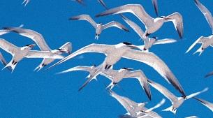
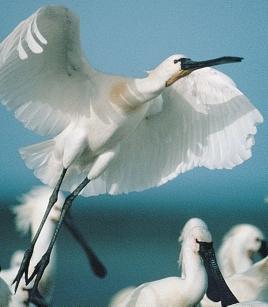
14 Controlling fishing and other human activities and their impacts on the environment requires high levels of investment. This applies not only to fighting illegal fishing but also to reducing industrial and urban pollution, monitoring the impacts of infrastructure works, coastal erosion, mangrove cutting and (possibly in the near future) oil drilling on coastal ecosystems. The spatial and temporal parameters of all of these activities change very rapidly, making it even more difficult to exercise control over them. Despite their limited financial resources, States have a responsibility to reinvest a part of the income stemming directly or indirectly from fisheries in research, management and monitoring, for these are the only guarantees of sustainable development of these resources. Marine Protected Areas: a life insurance policy for the fisheries sector In the current state of affairs, MPAs have a major role to play. As a response to the vulnerability of fisheries resources and the ineffectiveness of conventional management approaches, they provide a variety of advantages, such as higher fish density and larger invidual sizes which make adult migrations and larvae dispersal possible, thus replenishing stocks in fishing grounds. If they are correctly identified and accompanied by other management measures, these reserves act as insurance against the uncertainty inherent in fish stock assessments, fisheries management and controls in that they keep a part of the resource outside commercial channels. The abovementioned functions illustrate the role of MPAs in the fisheries economy. If, for example, Banc d Arguin National Park were no longer able to protect its sardinella nursery, it is likely that adverse effects would eventually be played out on industrial (especially European) fisheries catches as well as on local artisanal fisheries. Through their direct contribution to the improved vitality of the marine ecosystem and its resources, MPAs are, for all practical purposes, a life insurance policy for fisheries, and by the same token a guarantor of employment and food security for the region s population, hence the need for States to reflect this perspective in their national legislations. At the same time, MPAs shelter habitats which are essential for marine biodiversity in general. In fact, a significant percentage of West African biodiversity is found in areas enjoying (or soon to enjoy) legal protection: coral reefs (mainly in Cape Verde), the extremely rare monk seal, several cetacean species including dolphins, killer whales and whales, manatees and marine hippopotamuses, five endangered species of sea turtles, the world s largest concentrations of waterbirds, etc. 15
15 Marine Protected Areas a boon for human populations Most West African MPAs share a common feature: they are home to human communities who are also traditionally their resource users. Experience has shown that, except in a few cases, the protected status conferred on these communities home lands has proved crucial in preserving their cultural and social values. In return, these communities make a substantial contribution to MPA management and surveillance, through their deeply-rooted knowledge of the habitats and resources and by their physical presence. The structural cohesion of MPAs depends to a great extent on this two-way relationship between man and his environment. The existence of these areas of mutually enhancing cultural and natural diversity in turn provides opportunities in the fields of ecotourism, craftsmanship, education and scientific research. The need to meet the development requirements of communities living inside MPAs while complying with the restrictions which protected area status carries with it has prompted the creation of special development models for these areas. In the fields of fisheries, tourism and energy, MPAs have thus become pilot sites for experimental approaches which may in turn become models to be used in other areas. They are not isolated islands of wilderness where the overriding aim is to protect cultural and natural heritage at all costs. Inasmuch as they are part of a dynamic context which includes exchanges with the outside, they must be considered as parts of a whole which provides a great many services to human societies in general. In this respect, it is essential that populations and resource users have a good understanding of the value of MPAs, hence the need for an extensive communications programme. Bringing together local, national and regional priorities Developing an effective network of marine protected areas hinges on bringing together local, national and regional strengths. Each marine protected area operates at a local level, where the participation and support of local communities and stakeholders is absolutely imperative. Impacts (both positive and negative) are more immediately felt at this level where people are often asked to make significant investments of time and space. The success or failure of any protected area depends on adapting management approaches to their unique socioeconomic and natural environment to resolve problems that they themselves have identified. But individual protected areas must operate within a context defined by national policy and legislation. As marine protected areas are established, it is critical that certain elements of a country s protected area s management systems be harmonised. Each MPA needs a flexible yet comprehensive management plan with zoning, surveillance and business plans. Monitoring protocols must be comparable between sites to allow managers to compare data from different localities. Each must be based on the active participation of all stakeholders. How can protected areas be established if there is no legal basis to support them? How can co-management of sites be achieved if there are no enabling national policies? Clearly, the sustainability of conservation measures depends both on the effectiveness of on-site management and on the support provided by national level guidelines, policies and legislation. It is at national level that a country s environmental priorities are established, and it is at this level that conflicts at the local level may find resolution. It is also the role of national governments to ensure that key international agreements are adopted and implemented. Accession to conventions like the Convention on Migratory Species (CMS), 16

16 the Abidjan Convention, the Convention on Biological Diversity, Ramsar and many others provides an essential foundation for regional cooperation. These conventions reflect the shared aspirations of the participating countries and so provide common ground for dialogue and action. Studies carried out at regional level on the distribution, abundance and ecology of important coastal and marine resources can help to identify areas in need of protection or management from the bigger picture perspective. This is particularly important for the management of migratory species. Regional level analyses of environmental monitoring data can also help establish whether changes observed at particular sites are simply a local phenomenon or reflections of larger, more widespread environmental changes. Other activities of mutual interest like professional training, exchange visits and preparation for international conferences can also benefit from coordination at the regional level. Multi-level cooperation can also open the door to special fundraising opportunities a high priority for everyone. Many bilateral and multilateral agencies as well as private foundations recognise the importance of coordinating environmental management on a larger scale as a key component in the war against poverty and as a way to preserve many of the region s globally outstanding natural wonders. By creating a network of marine protected areas that respects local needs while integrating national and regional priorities, the regions institutions create a unique opportunity for the international community to support economic and environmental development at all levels simultaneously. 17
17 18
18 III - A Regional Strategy for the Marine Protected Areas of West Africa MPAs can no longer longer function as isolated pockets of nature having no continuity or interaction with their local and regional environment. Indeed, biogeographical connectors (such as the Canary Island and Guinea upwellings), biological exchanges (migratory species) and social and economic dynamics (artisanal and industrial fisheries, population flows) do not stop at the boundaries of MPAs or at national borders, and this forces us to rethink the role of these protected areas on a broader scale, from the perspective of regional coastal zone planning. This is an approach which draws directly upon the recommendations made by a New Partnership for Africa s Development NEPAD, and especially those which promote transboundary protected areas, as these are conducive to the development of tourism and thus job creation, while achieving nature conservation objectives. The ecoregional approach will make it easier to address the problems common to coastal habitats, small-scale fisheries and migratory species more rationally. Furthermore, it will foster more consistent conservation strategies through greater representativity of the habitats and species present, and through the network will also improve the effectiveness of MPAs by stimulating regional cooperation, institutional exchanges and training, not to mention the considerable potential economies of scale. Given the importance of MPAs for ensuring sustainable fisheries development and coastal and marine biodiversity conservation, the implementation of a West African strategy for MPAs is a golden opportunity for all interested parties in the region (e.g. fishing communities, central governments, NGOs, the private sector, international institutions and development cooperation agencies) to adopt a common position designed to meet the future needs of human societies and respond to the development challenges West African seaboard countries will face. The strategy will be aimed at ensuring that the coastal zone is maintained as an area of strategic interest for development. This document lays down strategic priorities for MPAs in the six countries which comprise the Subregional Fisheries Commission (CSRP). Its aims are in keeping with the priority directions adopted by the major international conventions in this field, in particular the Convention on Biological Diversity, the Bonn Convention (on migratory species), the Ramsar Convention (on wetlands), and the Washington Convention (on international trade in endangered species of flora and fauna). Its content is the culmination of a broad consultation process involving the entire range of MPA stakeholders. A series of regional workshops was held, first in Saint Louis, Senegal (April, 2000), then in Nouakchott, Mauritania (February, 2002) and finally in the Bijagos archipelago, Guinea-Bissau (December, 2002), where the strategy s action programme was presented and the mode of operation of the Regional Programme discussed. The content of the strategy presented on the following pages was opened for debate in each of the six countries through their national coastal planning networks. A fourth regional meeting is 19

19 planned in 2003 when the Council of Ministers of the Subregional Fisheries Commission meets in Dakar; the strategy will be presented officially along with its action programme so that the two can be validated at the political level. Finally, the entire body of proposals will be submitted to the 5th World Parks Congress in Durban, South Africa (September, 2003) where political leaders and donors will be asked to pledge their support. The adoption of the strategy will, however, be only the first step in a long process. In an initial phase ( ), the priority will be to implement its recommendations through specific actions and to strengthen actor capacity. During the subsequent phases, the MPA network will progress toward becoming part of an integrated coastal zone management perspective, first at national, then at regional level. 20

20 IV - A Shared Vision AN EFFECTIVE NETWORK OF MARINE PROTECTED AREAS IN WEST AFRICA WITH PARTICIPATIVE MANAGEMENT BY STRONG INSTITUTIONS, CONTRIBUTING TO THE SUSTAINABLE DEVELOPMENT OF THE REGION BY ENHANCING NATURAL AND CULTURAL DIVERSITY. 21
21
22 V - Strategic areas, objectives and priority activities Strategic area I: STRENGTHENING INSTITUTIONAL CAPACITY and MPA MANAGEMENT Vision: The institutions responsible for MPA management will be strengthened to enable them to meet environmental and economic challenges in a concerted and appropriate fashion, with the aim of making a tangible contribution to the sustainable management of resources, habitats and socioeconomic activities in the West African coastal and marine areas. Objective 1 The institutional and legal framework for MPAs is adapted to national and regional level. Activity 1.1: Promote the adoption of a general policy statement at regional level acknowledging the protection of the environment as a necessary component for development in coastal and marine areas. A regional strategy which places responsibility on States must be validated by a political commitment from the relevant authorities, first and foremost Ministers of the Environment and Fisheries. Such an undertaking, which could be modelled on the Arusha Resolution on the East African coastal zone, would guarantee a high long-term profile for issues on which MPA actors should focus their attention. Activity 1.2: Gain acknowledgment of the fact that MPAs are not only instruments for, but also actors in the fisheries management system. The role and needs of MPAs must be taken into consideration as part of the overall coastal zone planning process. It is particularly important that they be reflected in national and regional approaches to fisheries management, i.e. in negotiations on fishing agreements. Activity 1.3: Encourage state policies and private initiatives at regional or national level which contribute to the conservation and sustainable development of West African coastal areas. MPAs will only survive if the socioeconomic climate can provide a long-term guarantee of sustainable development in the region. It is therefore crucial to support public and private policies which promote sustainable development. 23
23 Activity 1.4: Foster the participatory approach and inter-institutional coordination at local, national and regional level by establishing or strengthening frameworks for consultation. Because of the wide range of actors involved in MPA management and the need to harmonise interests and responsibilities, the strategy actively promotes mechanisms for consultation. A few such mechanisms are already at work: at MPA level, the Assembly of the Bijagos Biosphere Reserve and the annual consultation workshop on fishing practices in Banc d Arguin National Park; at national level, the Advisory Committee on Mullet Fisheries in Mauritania, and at regional level the Regional Coastal Planning Network and the Subregional Fisheries Commission. Other formal or informal bodies could be set up to work in greater synergy towards common aims while at the same time mitigating possible conflicts. Activity 1.5: Grant MPAs their own specific legal identity and an appropriate national supervisory body. These measures are designed to improve MPAs ability to fulfill their mission within a coherent national framework. Their aims are twofold: firstly, to clearly define the rights and responsibilities of each individual MPA including Community-based Protected Areas as components of national coastal zone management policies, and secondly to facilitate coordination among all MPAs with respect to national, regional and international objectives. Activity 1.6: Encourage accession, ratification and implementation of international legal instruments relating to MPAs, or to the environment in general, by each country in the region. In order to harmonise regional policies on the marine environment, States should be encouraged to accede to or ratify international legal instruments like the Convention on Biological Diversity, the Bonn Convention (on migratory species), the Ramsar Convention (on wetlands), the Washington Convention (on international trade in endangered species of flora and fauna), the Abidjan Convention and the Global Code of Ethics for Tourism. 24
24 Objective 2 MPAs develop and implement management plans geared towards building their capacities. Activity 2.1: Draw up management plans for each of the region s MPAs. Management plans will be drafted by MPAs which do not yet possess one, drawing on shared experiences and common interests. All possible efforts will be made to harmonise these management plans so as to increase compatibility between approaches and facilitate regional co-operation. Activity 2.2: Provide MPAs with adequate technical resources (field infrastructure, equipment, logistics, boundary demarcation). MPAs are typically located in areas where surveillance is difficult, especially since the resources they harbour are increasingly sought after. There are many possible entry points, it is often difficult to delimit the marine boundaries and two surveillance systems are needed, one for the marine portion and one for the terrestrial area; all of these factors create tremendous requirements in terms of technical means. Activity 2.3: Increase staffing levels and train staff while working to harmonise training at regional level. MPA surveillance and monitoring are tasks which require an adequate number of qualified staff. In order to fulfill their mission, most MPAs need to hire additional staff. The regional approach will make it possible to organise training modules which can be used for all West African MPAs. These will be aimed not only at achieving economies of scale but also at strengthening institutional and personal ties and harmonising management tools. Activity 2.4: Complete zoning and boundary demarcation in MPAs using a participatory approach and involve resident populations in surveillance. For most existing MPAs, zoning is needed to delimit fishing and non-fishing areas and to distinguish strictly protected areas from sites where many human activities are permitted. In the spirit of co-management that the strategy endeavours to promote, zoning in existing MPAs and the delimitation of new MPAs should be based on a participatory approach encompassing all stakeholder groups. In MPAs where resources are plentiful, giving exclusive access rights to resident populations acts as a deterrent on non-resident fishermen. A system based on the watchfulness of communities living in the MPA, in conjunction with the surveillance and enforcement capacity of the relevant authorities can prove effective and affordable. Activity 2.5: Ensure that complete information regarding regulations reaches all stakeholders. Ensuring compliance depends on users being properly informed of the specific regulations in force in MPAs, especially when these users are fishermen who may travel beyond the borders of their own country and who are unfamiliar with the boundaries of the MPAs in the region. 25
25 Objective 3 A cohesive network of MPAs is managed in a coordinated fashion at regional level. Activity 3.1: Set up a regional network of MPAs which builds on existing networks: Biosphere Reserves, Ramsar sites, Subregional Coastal Planning Network. In keeping with the requirements of the regional approach to biodiversity management, especially as regards fisheries resources, MPAs must be brought together into one functional network. The fact that some MPAs are already part of existing networks (Biosphere Reserves, Ramsar sites) and that a network of experts on the West African coastal environment is already operational are building blocks toward the establishment of a network which will encompass all of the region s MPAs. The aims of this network will include consultation and implementation of joint strategies in fields of common concern. Activity 3.2: Complete the existing network by creating new MPAs. In West Africa, MPAs were not created as part of a master plan for an effective regional-scale network. But consistency must now be built into the network in order to preserve representative samples of the main ecosystem types, as well as habitats that are considered to be critically important as breeding areas for commercial fish species and for biological diversity as a whole. Furthermore, the dispersal cycles of larvae and adults of some commercially important marine species were not taken into account when MPAs were established, and the same holds true for the migratory patterns of wildlife species. A set of criteria must be defined by all stakeholders together in order to complete the network where necessary, including in areas of open sea. Activity 3.3: Harmonise legislation and planning regarding the management of shared species and habitats. The mobility of resources and of their users accentuates the need for countries to harmonise their legislation, and the strategy will promote this with a view to increasing consistency in management methods while at the same time facilitating understanding and acceptance by resource users. Fishing agreements between neighbouring countries providing the right to pursue and hail illegal fishing vessels, for example, are to be encouraged. Regional management plans will be drawn up for species (sharks, mullet, sea turtles) and for shared habitats (mangroves), as well as for common problems like coastal erosion. Activity 3.4: Train actors and managers through exchange visits and specially-designed training modules. Exchange visits will provide opportunities to highlight positive (and negative) experiences while building relationships between MPA actors in different countries and developing a regional sense of awareness and responsibility. The exchange visits, like the training programmes, are primarily intended for communities living in MPAs, but also for managers and other interested parties. Activity 3.5: Stimulate thinking at regional level on integrated coastal zone management in West Africa. MPAs will only be lastingly effective if the needs and interrelationships of the regional network are taken into account in the economic development process. By capitalising on available research tools, skills and networks, MPAs can become the catalysts needed to implement an integrated management strategy for the coastal zone; this would make it possible to meet the basic needs of human populations while preserving vital ecological processes. 26
26 Objective 4 A regional environmental education and communication policy on MPAs helps to gain the support of decision makers, local populations and the general public. Activity 4.1: Promote a regional approach to communications and environmental education regarding MPAs. Initiatives underway in individual countries will need greater support in order to achieve a better-coordinated approach to resources and shared problems. This will trigger the development of a regional sense of awareness and will also result in economies of scale through the pooling of training resources and joint production and dissemination of teaching and communications materials. Initiatives launched by local radio stations in this connection should be acknowledged and encouraged. A systematic effort will be made to stress the importance of expressing political support for MPAs as a region, i.e. during international meetings. Activity 4.2: Gain the support of populations, civil society and decision-makers for the MPA network strategy. A regional communications campaign focusing on the right target groups should help to convey the role and benefits of MPAs to populations and institutions concerned by the future of the coastal zone. It will also provide an opportunity to raise public awareness of the strategic importance of the coastal area in sustainable development policies for future generations. Activity 4.3: Develop a regional environmental education strategy and implement corresponding activities in every MPA. With a view to changing behaviours (especially among young people) in a lasting way, a regional environmental education programme will be developed and transposed into activities in each MPA to be accompanied by exchanges of views concerning the approaches and educational tools used. 27


27 Objective 5 Long-term funding measures for MPAs are put into place. Activity 5.1: Establish a financial management system for MPAs, striving to increase transparency. Rules for allocating financial resources, combined with strict management will guarantee transparency as regards income and expenditures, and this will be instrumental in building trusting relationships with the whole group of MPA institutional partners, a key requirement for lasting support. Activity 5.2: Develop a strategy to diversify sources of funding for MPAs. A collective brainstorming process will be launched in order to explore more sustainable funding mechanisms, emphasising the beneficiary pays principle and diversifying sources of funding (national and international, public and private). One specific measure to be considered is the establishment of trust funds for MPAs in the region with the support of the international community. Another possibility envisaged is to seek financial contributions to MPAs from economic sectors such as fishing, tourism and oil drilling. 28
28 Strategic Area II: The CONTRIBUTION of MPAs to RESOURCE MANAGEMENT and SUSTAINABLE DEVELOPMENT Vision: MPAs contribute, through participatory management, to the sustainable development of West African societies by protecting and enhancing the value of ecosystems that are essential for the survival and continued human use of the natural and cultural heritage. Objective 1 Participatory mechanisms are established as a foundation for sustainable local development. Activity 1.1: Define the roles and the responsabilities of the actors involved in managing and enhancing the profile of MPAs. One of the prerequisites for co-management systems is the designation of actors and the collective definition of their roles and responsibilities, as well as their respective rights and duties. The approach will emphasize traditional know-how and management rules. Management units adapted to the cultural situation will be put in place. Activity 1.2: Devise and establish consultation and decision-making processes for all stakeholders. In a situation where many resources are overexploited and where the pace of social, cultural and economic change is extremely rapid, consultation and decision-making processes are needed as a framework for defining avenues and modes of development. These mechanisms also aim to help resident populations gradually regain a sense of ownership for their area and its resources. Activity 1.3: Set up community funds using MPA-generated revenue and create local ad hoc structures to manage them; these funds will be used to carry out community-based projects. A part of the revenue generated by MPAs should eventually be returned to their resident communities in recognition of their contribution to managing the area, but also as a way of gaining their support for the objectives of the MPA which are relevant to them. Activity 1.4: Propose alternative socioeconomic and cultural development plans based on local experiences at MPA level. Given the restrictions associated with the protected area status, MPAs need to devise development models which provide an appropriate response to the requirements of sustainability. These models, which cover resource use, renewable energies and waste management, must be strengthened and extended to all MPAs in the region. They may also be shown as examples to other coastal areas outside MPAs. 29
29 Objective 2 The value of MPA fisheries resources is enhanced and they are exploited in a way which encourages their regeneration and respects ecological balances, to the benefit of responsible fisheries. Activity 2.1: Establish negotiated rules on the sustainable use of fisheries resources in MPAs which give precedence to resident communities and have no adverse effect on the regeneration of nationally or regionally important resources. The biological characteristics of commercially exploited species must be taken into consideration when establishing rules on fishing seasons, grounds and gear. The conditions must reflect the socioeconomic needs of resident communities, for example by granting them exclusive access (as in the case of the Banc d Arguin in Mauritania) or priority access to resources (as in the Rio Grande de Buba, Guinea-Bissau). Such rights must not, however, impinge on resource regeneration, which benefits fishermen operating outside MPAs. Conversely, the rules must provide safeguards so that harvesting outside MPAs will not have a negative impact on the resources used by populations inside their boundaries. Activity 2.2: Promote better value enhancement, processing and marketing of natural resources. This objective will be achieved by putting an end to unsustainable fisheries (sharks and rays) and destructive fishing techniques, and by developing economic alternatives and diversifying the range of marketed products. Other avenues to explore include devising systems to reduce bycatches, optimising exploitation and processing techniques, creating a regional MPA quality label, supporting local markets and establishing short economic cycles which would benefit resident communities. 30
30 Objective 3 Alternative economic activities are encouraged, especially those which benefit resident communities. Activity 3.1: Develop ecotourism while reducing its impact. On the whole, MPAs contain some of the region s most representative areas in terms of the natural and cultural heritage. This makes them ideal hubs for tourism development. However, these heritage components are particularly sensitive to different types of threats (changes in the economy and in human behaviour patterns, disturbances, harvesting, waste, etc.) The principles of ecotourism must be applied as this sector of activity develops within MPAs. Activity 3.2: Promote high-quality local craftsmanship. This traditional sector, which must operate in synergy with ecotourism, affords a good opportunity to enhance (and thus to safeguard for the future) the natural and cultural heritage which communities living in MPAs help to protect. Activity 3.3: Initiate pilot projects on alternative modes of development, building on success stories and exchanges at regional level. Alternative sustainable use activities (involving mangroves and other plant resources, shells, etc.) can be developed as a way of improving the standard of living of MPA communities, and pilot projects which have already been conducted in some MPAs can be a source of inspiration and ideas. Activity 3.4: Minimise the impact of human populations on the environment through a thorough situation analysis, the implementation of appropriate technologies and the adoption of community-based rules. The following are examples of plans which should be implemented: a waste reduction and management plan, a drinking water management and access plan, and an energy use plan. Environmental education programmes are equally important for developing more environmentally-friendly behaviours and lessening the populations impact on MPAs. 31
 should be shared during exchange visits, and through publications and various types of educational materials.")
31 Objective 4 The MPA network is instrumental in promoting sustainable management of shared resources. Activity 4.1: Spotlight successful experiences in participatory management in the region. Past and future success stories in sustainable participatory management (e.g. Rio Grande de Buba) should be shared during exchange visits, and through publications and various types of educational materials. Activity 4.2: Promote pilot development activities on a regional scale. One example could be an ecotourism programme covering several MPAs. This would make it possible to organise joint training sessions and would facilitate outreach and communications at regional level. Activity 4.3: Contribute to the debate on the development of undersea mining in general and offshore oil drilling in particular in countries directly affected by these activities. MPA managers and users could make a valuable contribution to the regional debate from the perspective of MPA values and functions and their sustainability. 32
32 Strategic Area III: SCIENTIFIC RESEARCH in MPAs Vision: Scientific research based on a common perspective and on monitoring coastal ecosystem functioning paves the way for the development of tools for medium-term and long-term decision-making on conservation and development issues facing MPAs in West Africa. Objective 1 Knowledge is organised and expressed using regionally homogeneous approaches and methodologies. Activity 1.1: Use the existing body of information and organise it using a pre-defined classification system and pre-agreed selection criteria. A bibliographical synthesis of publications about the region and a collection of indicators relevant to each field (geography, climate, fisheries resources, human societies, etc.) will be drawn up. Inventories of traditional knowledge about habitats and resources will be added to complete the picture. Combining different typological approaches from various fields, this information, organised into homogeneous data sets on the basis of a number of criteria, will then be used to produce a composite description of the coastal zone (including MPAs). Activity 1.2: Agree on a common understanding of West African coastal systems. A workshop to be attended by scientists working in the region will provide an opportunity to compare approaches to understanding long-term changes in the coastal environment stemming from climatic and human influences. Adopting a single view of the situation with respect to coastal ecosystems will make it possible to choose the major multidisciplinary models to fit the specific features of the West African region. Activity 1.3: Identify major multidisciplinary research issues for the West African coastal zone, and more specifically the regional network of MPAs. This multidisciplinary approach will ultimately lead to the definition of common research goals to be pursued by several major interdisciplinary programmes. 33
33 Objective 2 A general description of how the different systems function is obtained, then used to establish a scientific assessment of the West African coastal zone. Activity 2.1: Set up user-friendly data bases. A large body of information has been available in the region for the last 50 years (images, aerial photos, fish stock assessments, bird counts, information on social systems, human migrations, urban growth, climate trends, etc.) Once it has been standardised and classified, this material, which is valuable for analysing how the coastal environment has evolved since the mid-20th century, will be used to create a data base. A GIS Geographical Information System, a veritable multidisciplinary exchange platform, will make it possible to use the data base to carry out the research programmes previously defined. Activity 2.2: Pinpoint major gaps in scientific knowledge and initiate research to fill them. Identifying areas where research is lacking (undersea habitat mapping and the spatial distribution of fishing effort in relation to resource availability, to name but two) will provide guidance in launching much-needed research for each MPA and also at regional level. Activity 2.3: Highlight changes and analyse their causes, describe and model trend dynamics. Models will be adapted to reflect the actual situation and significant parameters identified through analyses of data series for long cycles (for example, a climatic model including hydrodynamic regimes like tides and currents). This will make it possible to pinpoint the major ecological and social trends driving environmental change and to find answers to questions like the following: 1-) Does the existing MPA network offer sufficient representativity of West African coastal systems diversity (flora and fauna diversity, natural habitats, cultural diversity)? 2-) What are the functional interactions between MPAs in physical terms (currents), biological terms (sea turtles, mullet, waterbirds) and social terms (human populations)? 3-) How can the role of MPAs in fisheries resource renewal be quantified at regional level? 4-) What coastal planning scenarios incorporating a strong MPA network can be put forward? Activity 2.4: Acquire functional models for the various systems. Mapping the different models and disseminating scientific publications will also help to illustrate the role of MPAs and to quantify their effectiveness for certain specific natural resources. 34
34 Objective 3 Monitoring and decision-making tools are developed and used toward sustainable management of MPAs in West Africa. Activity 3.1: Establish environmental monitoring centres ( Observatoires ) for data gathering. Identifying the causes of environmental change and understanding the interactions between the climate and human societies will enable us to describe the degree of environmental sensitivity and fragility to a number of forces of change. The next step will be to identify relevant indicators for the long-term monitoring of the coastal zone. The establishment of environmental monitoring centres responsible for collecting and processing data needed to track changes will ensure that the basic tools for long-term MPA management are available. This stage of the strategy is crucial to the development of a regional scientific repository and to the activation of surveillance networks. Activity 3.2: Establish sets of framework indicators to be used as management and decision-making aids. Regional indicator collection, entry and processing systems will lead to the production of sets of framework indicators describing year-to-year environmental change. This should lead to the development of early warning systems to aid managers and, in more general terms, enrich the integrated coastal zone planning process. Objective 4 Forward-looking analyses are carried out at the request of managers or decision-makers on West African coastal zone issues. Activity 4.1: Formalise the main management scenarios in consultation with MPA managers and users. Simulation models based on clear medium and long-term objectives will provide a platform for exploring planning options together with all stakeholders, by suggesting hypotheses and scenarios which will make it possible to gauge the possible consequences of management measures on natural resources and habitats. Activity 4.2: Make these projections available to stakeholders and provide risk assessment and management tools. The results of the abovementioned analyses will be extrapolated into several management options and should lead to the formulation of clear recommendations for managers and decision makers. A precise assessment of sensitivity and vulnerability levels, including technological (accidental pollution) and climatic (storms, rise in sea level) risk factors, will guide the development of a regional risk management approach for the coastal zone. 35
35 Objective 5 New tools facilitate the emergence of scientists qualified to deal with scientific issues specific to the West African coastal zone. Activity 5.1: Establish a virtual documentation centre. This will be an open-access website which will simplify information retrieval and allow on-line consultation of electronic documents using keywords, within a predefined format. Activity 5.2: Set up Internet discussion groups for scientists. Setting up and operating Web discussion groups for researchers and students working in the region will stimulate information exchanges; this will be done by creating an electronic mailing list and using the Subregional Coastal Planning Network. Activity 5.3: Improve training on West African coastal zone issues. Training courses specifically focusing on the West African coastal zone and geared toward researchers and technicians will be offered as part of the curricula of the individual countries of the region. 36

36 APPENDICES MPA Fact sheets and maps List of institutions involved in developing the strategy List of workshop participants and individuals involved in developing the strategy List of abbreviations and acronyms 37


37 38 CAP BLANC SATELLITE RESERVE
38 Country: MAURITANIA CAP BLANC SATELLITE RESERVE Geographical Location: The reserve has two parts, one terrestrial and the other marine. The terrestrial area is a 100 m-wide strip starting at the low-water mark which stretches from Porta Ilia in the west ( N and W) to the northern edge of Cap Blanc beach in the east ( N and W). The length of the coastal section is 4.2 km. The marine portion of the reserve is a strip 400 m wide which runs from Porta Ilia to the eastern edge of Cap Blanc beach. The reserve has a total surface area of 210 ha. Date of Establishment: 2 April, 1986 by decree (86-060) Relevant Institutional Authorities: - Prime Minister s Office / Secretariat General of the Government - Banc d Arguin National Park Authority Resident Human Communities: None Natural Features: Cap Blanc peninsula is formed by calcareous sandstone cliffs called Aguerguer, with a strand exposed to wave action on the ocean side and sheltered on the Baie du Lévrier side, extending upstream in the shape of a sand spit. The land surface area is 42 ha. The marine area (168 ha) is located on the site of a strong upwelling. Fauna: Monk seals (< 5), mainly solitary males. Cetaceans. Major roosting site for seabirds, mainly Sterna sp. and Chlidonias sp. either stopping over during their post-breeding migration (< 30,000 individuals) or nesting (< 10,000 ind.). Large numbers of passerines and raptors during the postbreeding migration. Fish (Mugil sp., Morone sp.) crustaceans (Palinurus sp.) and molluscs (Mytilus sp.), also in high numbers. Vegetation: Vegetation is sparse on the land side: Artrochnemum sp., Traganum moquini. The marine flora is much more varied. There are several species of algae and huge quantities of phytoplancton, predominantly diatoms. Key Objective of the MPA: Protect the monk seal and marine fauna in general. Provide environmental education. 39


39 40 BANC D ARGUIN NATIONAL PARK
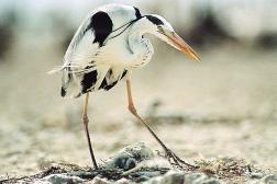
40 Country: MAURITANIA BANC D ARGUIN NATIONAL PARK Geographical Location: Banc d Arguin National Park s boundaries are delimited as follows: its southern limit is set at N, to the east the boundary roughly follows the coastline some way inland, and the northern and western boundaries are N and W. Its surface area totals 1,170,000 ha. Date of Establishment: 24 June, 1976 by decree establishing Banc d Arguin National Park and 19 January, 2000 by Law Relevant Institutional Authorities: - Prime Minister s Office / Secretariat General of the Government - PNBA Banc d Arguin National Park Administrative Authority Resident Human Communities: Nine villages of indigenous Imraguen people live inside the park. The total population of these villages is estimated at 1,300. There are also a few camps inhabited by nomadic pastoralists. Natural Features: The land portion of the park occupies some 5,830 km 2 of Sahara desert-like terrain, and the marine area covers 6,245 km 2. It is worth noting that the island of Tidra holds the northernmost formation of olive mangroves (Avicennia africana) on the African coast. Along with with the presence of the nearby ocean upwelling, the approximately 450 km 2 of intertidal mudflats covered by Zostera noltii and Cymodocea nodosa seagrass beds and the vast shallow areas sheltered from oceanic influences by the plateau called the Banc d Arguin account for the high level of ocean productivity. Fauna: Large terrestrial fauna is rare, the main species being Gazella dorcas, Canis aureus, Vulpes rüpelli, Fennecus zerda, Hyaena hyaena. The park s marine fauna is diverse and abundant. In addition to fish (over 140 temperate and tropical species), crustaceans and molluscs, mammals such as Tursiops truncatus, Sousa teuszii and Orcinus orca occur, and the first two of these three species are known to fish in symbiosis with Imraguen fishermen during mullet (Mugil sp.) migration. Several species of sea turtles are found in Gulf of Arguin, Chelonia mydas being by far the most common. Satellite tracking of their migratory movements indicates that these turtles come mainly from breeding grounds in the Bijagos archipelago, since there are few nesting sites within the park. The park s birdlife is first and foremost characterised by the world s largest concentrations of wintering waders, some 2.5 million birds, in addition to 30,000-40,000 nesting pairs of colonial species like Phoenicopterus, Platalea, Ardea, Phalacrocorax, Sterna, Larus, etc. Key Objective of the MPA: Contribute to sustainable development in Mauritania by protecting habitats which are crucial for the regeneration of fisheries resources; preserve biological diversity and cultural heritage. Protect natural sites of major scientific, archeological and esthetic value and promote environmental education. Other Protected Status: Ramsar site, 1983 World Heritage site, 1989 Gift to the Earth,


41 42 DIAWLING NATIONAL PARK AND CHAT T BOUL RESERVE
42 Country: MAURITANIA DIAWLING NATIONAL PARK AND CHAT T BOUL RESERVE Geographical Location: N and W. Surface area: 18,095 ha Date of Establishment: 14 January, 1991 by decree (91-005) Relevant Institutional Authorities: - Ministry of Rural Development and the Environment - Diawling National Park Authority Resident Human Communities: The Park s population totals between 30,000 60,000 people (sedentary and nomadic) from three ethnic groups (Moor, Wolof and Peul). Natural Features: Floodplains with highly saline clay and silty clay soils. Three protected basins (Diawling, 7,200 ha; Bell, 4,500 ha; Gambar, 3,900 ha) make up the total area of 16,000 ha. The peripheral zone, which is not part of the protected area, includes a marine zone, a coastal dune cordon, stabilised dunes further inland (Birette and Ziré) and a river and estuarine fringe. Fauna: Huge flocks of birds, both migratory and sedentary. Other species occurring include Otis and Balearica. As regards mammals, large numbers of Phacochoerus and Canis aureus can be seen throughout the year within the Park and in the peripheral zone. Terrestrial reptiles are common. Last but not least, there is a variety of freshwater and estuarine fish species to be found in the three basins and permanent marshes ( marigots ) of the protected area and peripheral zone. Vegetation: Woody species dominate, mainly different Acacia species, Avicennia africana, Tamarix senegalensis, Prosopis and Salsola sp. in the plains. Grassy plants are represented here by Sporobolus robustus and pastures of graminaceous species. The most common aquatic plants are the invasive species Typha and Salvinia molesta. Key Objective of the MPA: Restore the ecosystems of the lower Mauritanian delta, preserve the area s natural resources for the local communities which depend on them. Other Protected Status: Ramsar site,

43 44 LANGUE DE BARBARIE NATIONAL PARK
44 Country: SENEGAL LANGUE DE BARBARIE NATIONAL PARK Geographical Location: Langue de Barbarie National Park, located 25 km south of the town of Saint-Louis, is composed of a barrier spit and a marine zone. It occupies an area of 2,000 ha. The Park stretches 15 km in length to the mouth of the Senegal river (16 30 N to W), and is 700 m to 1 km wide. Date of Establishment: 9 January, 1976 by decree ( ) Relevant Institutional Authorities: - Ministry of the Environment and Nature Protection - Department of National Parks Resident Human Communities: Some 10 villages surround the Park. Their populations are made up of 65% Wolofs, 25% Peuls and 10% Moors. Natural Features: Langue de Barbarie National Park is set between the Senegal river and the ocean. Its dominant biotopes are fixed sand dunes on the seaward side, and casuarinas. Since the Diama dam was commissioned, the downstream portion of the river has functioned partially as a lagoon. A small island m in diameter, known as L Ilot aux Oiseaux, is located 5-7 km from the river mouth. Fauna: The Park s importance is chiefly due to its nesting populations of colonial birds, especially species of three genera - Sterna, Larus and Egretta, and to the presence of wintering species such as Pelecanus, Ardea cinerea and Larus. The sandy beach on the seafront is a nesting ground for sea turtles. Vegetation: The dominant plant species on dry land is Prosopis juliflora. In some areas of the Park there are relict Avicennia mangroves. Areas with halomorphic soil support species like Ipomea and Sesuvium. Key Objective of the MPA: Preserve biodiversity in the lower Senegal River delta; protect the turtle nesting beach. Another aim is to promote scientific research and tourism. The Park has between 3,000 and 4,000 visitors per year. 45


45 46 MAGDALEN ISLANDS NATIONAL PARK
46 Country: SENEGAL MAGDALEN ISLANDS NATIONAL PARK Geographical Location: The Magdalen islands are located 3.6 km west of Dakar (14 40 N W). They have a surface area of 15 ha in addition to which there is a peripheral zone of some 30 ha made up of the sum of the 50 meters of sea ringing each island. Date of Establishment: 16 January, 1976 by decree ( ) Relevant Institutional Authorities: - Ministry of the Environment and Nature Protection - Department of National Parks Resident Human Communities: None. Natural Features: Rocky volcanic islets, steep cliffs and basalt columns, dry savanna, (the islands are uninhabited). Fauna: The marine fauna of the park is diverse, with demersal species such as Epinephelus and pelagic species like barracuda, Thonidae, etc. The Park is also noteworthy for several nesting bird species, one of which is the extremely rare Phaeton aethereus (approx. 30 pairs) and several pairs of Corvus albus, Milvus migrans and Euplectes. Records of migratory species include numerous sightings of Falco peregrinus, Pandion haliaetus, Sula sp., Sterna sp. Reptiles include Psammophis sibilans, several lizards and one species of gecko. Vegetation: J.G. Adams counted 101 plant species on these islands in The most interesting are perhaps the Euphorbiaceae Jatropha curcas and the stands of dwarf baobabs (Adansonia digitata). The dominant grass is Andropogon gayanus. Key Objective of the MPA: Preserve the habitat and biological diversity of the islands. 47

47 48 POPONGUINE NATURE RESERVE
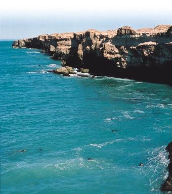
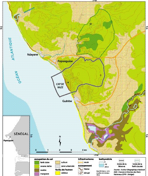
48 Country: SENEGAL POPONGUINE NATURE RESERVE Geographical Location: Poponguine Nature Reserve is located on the Senegalese coast about 60 km south of Dakar (14 30 N 17 6 W). It is made up of two parts, a terrestrial part covering 1,009 ha, and a marine strip - nautical mile wide. Date of Establishment: 21 May, 1986 by decree Relevant Institutional Authorities: - Ministry of the Environment and Nature Protection - Department of National Parks Resident Human Communities: None. However, the populations of the 8 villages on the periphery of the reserve take an active part in restoration and development activities on a voluntary basis. Natural Features: The terrestrial portion of the reserve is characterised by its extremely rugged relief. It is made up of a chain of hills rising up towards a calcareous sandstone cliff 74 meters above sea level which extends into the ocean, forming a rocky, shallow water area where many marine species breed. Rocky laterite soil is predominant because of the site s extremely deteriorated condition at the time the reserve was established. A temporary lagoon is the only water body in the reserve. Fauna: The restoration process begun in 1986 with the prohibition of grazing, and with the help of local communities has resulted in the tentative reappearance of animals which had long since vanished from the area: Tragelaphus scriptus, Cephalophus grimmia, Cercopithecus aethiops, Crocuta crocuta, Canis aureus, Ictonyx striatus and Viverra civetta make up the terrestrial mammal community. Migratory birds use the lagoon from November to February alongside local species (Streptopelia sp., Psittacula krameri and the rare Monticola solitarius). Several reptiles are also present, among them Python sebae and Varanus niloticus. Information regarding the reserve s marine fauna remains sketchy. Vegetation: The vegetation is Sahelian, predominantly thorny, with a stand of Acacia nilotica, Posopis fuliflora, Adansonia digitata and a few Combretaceae. Key Objective of the MPA: Rehabilitate an area damaged by man and by repeated droughts. 49

49 50 SALOUM DELTA NATIONAL PARK AND BIOSPHERE RESERVE
50 Country: SENEGAL SALOUM DELTA NATIONAL PARK AND BIOSPHERE RESERVE Geographical Location: N and W Date of Establishment: National Park: 28 March, 1976 by decree (59,934 ha) Biosphere Reserve: 1981 (222,062 ha) Relevant Institutional Authorities: - Ministry of the Environment and Nature Protection - Department of National Parks Resident Human Communities: Some 200,000 people live in 5 villages set within the reserve. Natural Features: A coastal and marine fringe includes several small islands and sand bars. Three large groups of islands (Fathala, Gandoune and Betenty) make up an amphibious complex. The continental side is typified by tannes, mangroves, open forests, savanna woodland and scrub savanna. Fauna: In addition to 114 fish species from 52 families, the area boasts crustaceans (Penaeus notialis and Penaeus kerathurus, Callinectes sp., Cardiosoma armatum) and molluscs (Crossostrea gasar, Cymbium sp., Murex sp., Arca senilis). Aquatic reptiles such as Crocodylus niloticus and several species of sea turtles are also present. Among the mammals occurring are manatees (Trichechus senegalensis), dolphins (Tursiops truncatus, Sousa teuszii) and the African clawless otter, Aonyx capensis. 34 species of terrestrial mammals have been recorded, 7 of which are endangered in Africa. Three of these are Redunca redunca, Tragelaphus spekei, and also a population of 600 Colobus badius which is remarkable at this distance from dense forest. About 120,000 nesting, wintering and migrating birds of over 300 species are recorded each year, noteworthy examples being the many waders and Ardeidae, as well as Sterna maxima which gathers here to form one of its largest colonies in the world here. Vegetation: The dominant vegetation type is mangroves, with a succession moving inland from the sea: Rhizophora, Avicennia, Sesuvium and Paspalum meadows, Conocarpus, and finally Laguncularia. A total of 188 plant species have been recorded. Key Objective of the MPA: Protect delta ecosystems, preserve biological diversity, restore ecosystems, preserve local cultural heritage, promote scientific research, education and nature observation tourism. Other Protected Status: Ramsar site,

51 52 NUIMI NATIONAL PARK
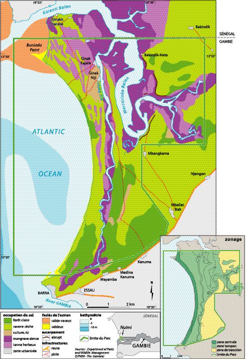
52 Country: THE GAMBIA NUIMI NATIONAL PARK Geographical Location: Niumi National Park has a surface area of 4,940 ha which encompasses the southern tip of the Siné- Saloum delta. It is centred on N W on the north bank of the River Gambia in Lower Niumi District, North Bank Division. The Park boundary extends from Barra Point at the mouth of the River Gambia north to the border, covering the low sandy island of Jinack, then east along the Masarinko Bolon to the upper limit of saline intrusion. It is contiguous with Saloum Delta National Park and Biosphere Reserve in Senegal. Date of Establishment: 1986 (Law under Section 5.2 of the 1997 Wildlife Act) Relevant Institutional Authorities: - Department of State for Fisheries, Natural Resources and Environment - Department of Parks and Wildlife Management Resident Human Communities: Eleven peripheral villages use the park, of which three (Jinack Niji, Jinack Kajata and Barra) are actually situated within the park area. Their populations depend on the park for a number of activities including rice, millet and groundnut production, fishing and oyster harvesting. Natural Features: Niumi National Park encompasses the island of Jinack which is separated from the mainland by the narrow Niji Bolon. The island is mainly low tying with extensive areas of coastal dune woodlands, saltwater marshes dominated by tamarisk and mangrove fringing the bolon. The main section of the park incorporates dry woodland and grassland savanna on a raised laterite plateau. Fauna: The fauna of the area is diverse albeit not exceedingly abundant. It includes the West African manatee (Trichechus senegalensis) and the Atlantic humpbacked dolphin (Sousa teuszii). Green turtles (Chelonia mydas) occur along the coast of Jinack island. Nile crocodiles (Crocodylus niloticus), snakes and lizards are recorded as well. Some 300 species of birds from 63 families have been recorded in Niumi National Park to date. Larger mammals such as Hyaena, Panthera pardus and primates are still relatively abundant. Vegetation: Niumi is a mosaic of wetlands and vegetation types ranging from sandspits and brackish lagoons to seasonal freshwater marshes. Key Objective of the MPA: Preserve biological diversity, involve of local communities and improve their livelihoods. Other Protected Status: Biosphere Reserve (proposed) Ramsar site (proposed) 53


53 54 BIJOL ISLANDS AND TANJI RIVER BIRD RESERVE
54 Country: THE GAMBIA BIJOL ISLANDS AND TANJI RIVER BIRD RESERVE Geographical Location: Tanji River Bird Reserve and Bijol Islands are situated along the Atlantic coast in the Western Division Kombo North at W and N. The reserve encompasses the Tanji River and its estuary, incorporating mangrove, dry woodland and coastal dune scrub woodland. It has a total area of 612 ha. Bijol Islands are the only offshore islands along the Gambian coast. Date of Establishment: L.N. 15 of 1993 Relevant Institutional Authorities: - Department of State for Fisheries, Natural Resources and Environment - Department of Parks and Wildlife Management Resident Human Communities: Four villages (Brufut, Madiana, Tanji and Ghanatown) surround Tanji River and Karenti Bird Reserve. The villagers use the park for various activities such as farming, gardening, collecting firewood, collecting honey and cultural practices. Natural Features: Bald Cape is formed from a shallow reef of laterite rock which extends to the northwest, reappearing in the Bijol Islands. The cape is backed by a lagoon which runs south in a broken chain as far as the village of Tanji. The lagoon system has developed from a combination of outflow from the Tanji River and sand deposits accumulating due to the longshore drift. It is a dynamic system and significant changes can result from a single flood or storm. The cape and lagoons serve as feeding and roosting grounds for a wide variety of gulls, terns and waders. Fauna: Bijol Islands provide the only known breeding site in the country for Sterna caspia, Sterna maxima and gulls at the present time. The surrounding waters are used by Monk seals Monachus monachus, Atlantic humpbacked dolphins Sousa teuszii, and turtles. The reserve harbours a diverse group of mammal, primate and reptile species. Vegetation: There is a wide variety of habitat types including marine, estuarine, freshwater, coastal scrub woodland and dry woodland savanna. The dominant species are the gingerbread plum (Parinari macrophylla), the rhun palm (Borassus aethiopium) and the baobab (Adansonia digitata). Key Objective of the MPA: Conserve the area s biodiversity, involve local communities in the management of the area and provide additional/alternative sources of income for them. Other Protected Status: Ramsar site (proposed) 55

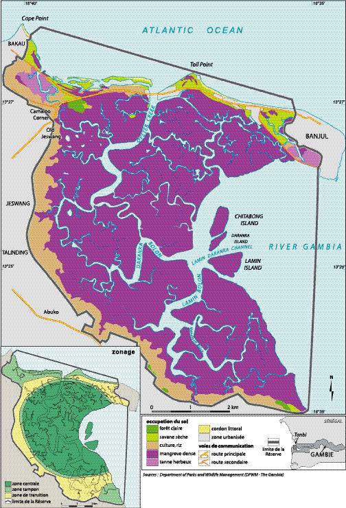
55 56 TANBI WETLAND COMPLEX
56 Country: THE GAMBIA TANBI WETLAND COMPLEX Geographical Location: The Tanbi Wetland Complex is located on the southern bank of the River Gambia; it includes the area between the island of Banjul and Cape Point and extends to Lamin and Mandinari Point in the south. Its central co-ordinates are N and W. The wetland area fronts the ocean to the north and the River Gambia to the east. Tanbi Wetland occupies an area of approximately 6,000 ha, the majority of which is made up of overwash and fringe mangrove forest. Date of Establishment: December, 2001 GOTG Relevant Institutional Authorities: - Ministry of Fisheries, Natural Resources and Environment - Department of Parks and Wildlife Management Resident Human Communities: Tanbi Wetland Complex is surrounded by the densely populated city of Banjul and by other towns and villages such as Bakau, Jeshwang, Lamin, Mandinari, Tallinding and Abuko. The major human activities in the complex include: agriculture (vegetable gardening), fishing, river excursions (ecotourism), oyster harvesting and industry. Natural Features: Tanbi Wetland Complex occupies the southern portion of the River Gambia estuary. It is primarily made up of low mangrove forest, with a complex of vegetation types on its northern boundary (which is formed by a sand spit connecting Banjul to Cape Point) and along the mangrove which fringes the mainland. Its functions include stabilisation, acting as a sewage sink for the urban area, fish breeding and recreation. Fauna: The mammalian fauna of Tanbi Wetland Complex is inevitably the result of its proximity to the major urban areas surrounding it. The current list of bird species for Tanbi stands at 362 species and 66 families. Reptiles such as snakes, lizards, turtles and crocodiles occur within Tanbi Wetland Complex. Vegetation: Tanbi Wetland is located at the mouth of the River Gambia and contains a variety of habitat types. Mangrove forest dominates south of the Banjul highway. The main species is Rhizophora mangle, although R. harrissoni, R. racemosa, Avicennia africana, Laguncularia racemosa, Annona glabra and Conocarpus erectus also occur. Key Objective of the MPA: Conserve biodiversity in the area, encourage river tourism and provide alternative sources of livelihood for associated communities. Other Protected Status: Ramsar site (proposed) 57

57 58 BAO BOLON WETLAND RESERVE
58 Country: THE GAMBIA BAO BOLON WETLAND RESERVE Geographical Location: Bao Bolon Wetland Reserve is located on the north bank of the River Gambia, approximately 100 km (52 nautical miles) from the river mouth. The reserve takes its name from the Bao Bolon tributary which rises in Senegal and enters the River Gambia southeast of Katchang. Its central co-ordinates are N and W, and it covers approximately 22,000 ha. The reserve extends from the River Gambia north to the Senegalese border along the Bao Bolon tributary, although the Senegalese side of the Bao Bolon has not been granted any protected status. Date of Establishment: 1996 Relevant Institutional Authorities: - Department of State for Fisheries, Natural Resources and Environment - Department of Parks and Wildlife Management Resident Human Communities: 25 villages border the reserve and another sits within its boundaries. The internal and peripheral villages are dependent on the park for numerous activities including agriculture, fishing, grazing and timber and wood gathering. Natural Features: Bao Bolon Wetland Reserve is not officially gazetted to date and awaits confirmation of the proposed boundaries. There is no physical demarcation on the ground at this time. The Government of the Gambia declared it a protected area in order to preserve the entire wetlands habitat and its associated fauna and flora. Fauna: The mammalian fauna of Bao Bolon is relatively rich and is heavily influenced by the wetland nature of large parts of the reserve. To date 32 species have been recorded, including large mammals such as Panthera pardus, Hyaena, Redunca redunca and Tragelaphus spekei. Primates are still fairly common, especially Papio anubis, Galago senegalensis and Colobus badius. Aquatic mammals are quite abundant. Both Trichechus senegalensis and Aonyx capensis are known to occur in the bolons. The current bird list for Bao Bolon stands at 268 species from 62 families. Six families of fish have been recorded in the reserve, including Tilapia species and mullets. Reptiles and amphibians also occur in large numbers. Vegetation: The Bao Bolon Wetland Reserve displays a rich patchwork of habitat types which roughly follow a gradient starting with the high mangroves of the River Gambia, through permanent salt marsh, bare tannes and seasonal freshwater marshes, grading finally into wooded grassland. Key Objective of the MPA: Conserve coastal and marine biodiversity, involve local communities, provide alternative sources of income for associated communities, develop local skills. Other Protected Status: Ramsar site,


59 60 RIO CACHEU MANGROVE NATURAL PARK
60 Country: GUINEA-BISSAU RIO CACHEU MANGROVE NATURAL PARK Geographical Location: The Park is located in northwestern Guinea-Bissau between N and W. It has a surface area of 88,615 ha, 68% of which is covered by mangrove forests. It is made up of two discrete parts which are separated by the Cacheu River and differ from one another not only in their ecological features but also from a social, cultural and economic point of view. Date of Establishment: December, 2000 by decree law 12/2000 Relevant Institutional Authorities: - Ministry of Agriculture, Forests and Pastoralism Resident Human Communities: The northern area of the park has a population of 7,120 inhabitants living in 27 villages and belonging to six ethnic groups. In the southern sector, there are 14 villages with approximately 830 inhabitants belonging predominately to two ethnic groups. Natural Features: The park is largely made up of mangroves (68% of its total surface area) which are part of a more extensive mangrove forest considered to be the largest contiguous one in West Africa. Fauna: The vast mangrove area is an ideal habitat for large numbers of migratory birds during the winter months. Mammals occurring in the park include Sousa teuzsii, Tursiops truncatus, Hippopotamus amphibius, Trichechus senegalensis, Crocodylus niloticus and Crocodylus tetraspis, Tragelaphus scriptus and Cercopithecus aethiops. Key Objective of the MPA: Protect the mangroves as areas for fisheries resource reproduction. Preserve fauna and flora diversity and improve living conditions for the human population. Other Protected Status: Ramsar Site, Proposal submitted in June,


61 62 BOLAMA BIJAGOS ARCHIPELAGO BIOSPHERE RESERVE
62 Country: GUINEA-BISSAU BOLAMA BIJAGOS ARCHIPELAGO BIOSPHERE RESERVE Geographical Location: Bolama Bijagos Biosphere Reserve is located off the West African coast between N and W. This is an archipelago comprising 88 islands and islets covering a total surface area of 1,046,950 ha. The archipelago is set at the meeting point of the north and south Atlantic longshore drifts. Date of Establishment: 16 April, 1996 UNESCO Relevant Institutional Authorities: - INEP (National Research Institute) - IUCN (The World Conservation Union) Resident Human Communities: The total population of 27,000 inhabitants lives in 185 villages on the archipelago s 21 inhabited islands. Nearly 90% of the archipelago s human population are Bijagos. The remaining 10% is made up of Balanta, Papei, Manjaco and Mandinga as well as Nyominkas from Senegal, Sierra Leonese, Guineans and Ghanaians. These latter groups sometimes set up camps on various islands which they use year-round or for the duration of the fishing season. Natural Features: The archipelago is deltaic in origin. The seaward side is made up of vast extenses of sandy-muddy intertidal flats intersected by channels of varying depth (tidal amplitude is about 4 m at spring tide) and fringed by mangroves. On the landward side are stands of palm trees, coastal scrub savanna and semi-dry forests. Fauna: The archipelago is home to a wide variety of mammals, reptiles, birds and fish. It is known to be the largest nesting site on the Atlantic coast of Africa for Chelonia mydas, with over 7,000 nests annually. Other rare or protected species are still relatively plentiful here, for example Crocodylus niloticus and Crocodylus tetraspis, Hippopotamus amphibius, Trichechus senegalensis, Sousa teuzsii and Tursiops truncatus. Each year the archipelago plays host to nearly 800,000 wintering Palearctic waders as well as nesting colonial waterbirds. Key Objective of the MPA: Protect biodiversity and associated ecological processes by promoting traditional management of land and resources and keeping the Bijagos culture alive. Improve the population s living conditions using a development model based on wise and sustainable use of natural resources. Improve scientific knowledge about the region and propose alternatives for sustainable development, implement efficient management mecanisms. 63

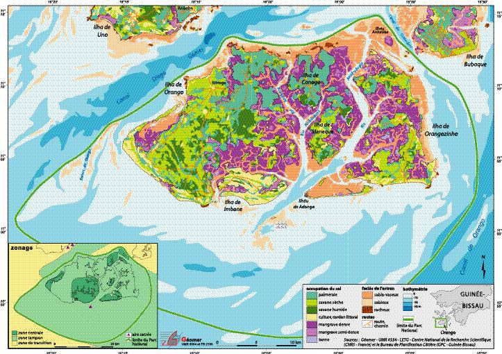
63 64 ORANGO NATIONAL PARK
64 Country: GUINEA-BISSAU ORANGO NATIONAL PARK Geographical Location: The park is located in the southern portion of the Bijagos archipelago between N and W. It covers an area of 158,235 ha and encompasses 5 large islands (Orango, Orangozinho, Meneque, Canogo and Imbone) and 3 smaller ones (Adonga, Canoupa and Anhatibe). Water depth is less than 30 meters throughout the park s marine area. Date of Establishment: December, 2000 by decree law 11/2000 Relevant Institutional Authorities: - Ministry: Ministry of Agriculture, Forests and Pastoralism - Biosphere Reserve Resident Human Communities: The human population within the park is 2,268 inhabitants spread over 33 villages. The bulk of the population belongs to the Bijagos ethnic group. Other groups are present, such as Nyominkas fishermen from the Saloum region, but these account for no more than 5% of the total population. Natural Features: The park has an extensive mangrove coverage of some 16,000 ha. The mangrove biotope plays a key role in primary ocean resource production throughout the archipelago as well as providing breeding areas for a wide variety of fish and shellfish species. On the landward side, typical vegetation types are oil palms Elaeis guineensis and coastal scrub savannah. Fauna: The park s fauna shows high diversity and numbers, especially in the south where the archipelago s largest populations of hippopotamus (Hippopotamus amphibius) and crocodile (Crocodylus niloticus and Crocodylus tetraspis tetraspis) are found. Five sea turtle species (Chelonia mydas, Eretmochelys imbricata, Lepidochelys olivacea, Caretta caretta and Dermochelys coriacea) also occur in the park. Mammals include Tragelaphus scriptus, Cercopithecus aethiops and the marine species Aonyx capensis, Trichechus senegalensis, Sousa teuszii and Tursiops truncatus. The park also has a rich fish and invertebrate fauna. In terms of birdlife, Orango National Park is a site of international importance for several Palearctic waders and colonial seabirds like Sterna caspia and S. maxima. It is also an important site for the rare and endangered African grey parrot Psittacus erithacus. Key Objective of the MPA: Protect and enhance ecosystems; preserve biological diversity and ensure that natural resources are used sustainably so as to improve the social and economic well-being of the human population. Other Protected Status: Biosphere Reserve, 16 April, UNESCO 65
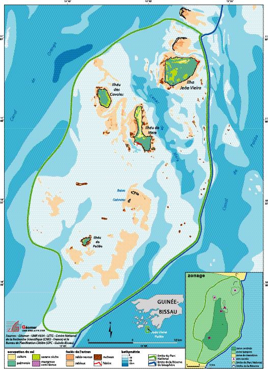
65 66 JOÃO VIEIRA-POILÃO ISLANDS MARINE NATIONAL PARK
66 Country: GUINEA-BISSAU JOÃO VIEIRA-POILÃO ISLANDS MARINE NATIONAL PARK Geographical Location: The park is located in the southeastern part of the Bijagos archipelago between N and W. It has a surface area of 49,500 ha which encompasses 4 main islands (João Vieira, Cavalos, Meio and Poilão) and 3 smaller islands (Baixo de Muzanty). Date of Establishment: August, 2000 by decree law 6-A / 2000 Relevant Institutional Authorities: - Ministry of Agriculture, Forests and Pastoralism - Biosphere Reserve Resident Human Communities: The islands have no permanent inhabitants. The four main islands are by tradition the property of four villages on Canhabaque island who use them periodically for rice growing, harvesting various oil palm products and conducting religious ceremonies. Natural Features: Land cover on the islands is subhumid Guinean forest and palm forest. Oil palms (Elaeis guineensis) are the dominant vegetation type. They are found in association with other tree, shrub and grass species. There are mangrove forests in the intertidal zone. Fauna: Three sea turtle species occur on the park s beaches: the green turtle (Chelonia mydas), the Atlantic hawksbill turtle (Eretmochelys imbricata) and the Olive Ridley turtle (Lepidochelys olivacea). During monitoring studies on Poilão in 2000 and 2001, nearly 7,000 nesting female green turtles were recorded. The island of Poilão is the most important nesting site for this species in the entire Eastern Atlantic. Marine mammals also occur in the park, including two dolphin species (Sousa teuszii and Tursiops truncatus). The fish fauna is abundant and diverse. The most common species are Caranx, Lutjanus and Epinephelus, and sharks. The park is the breeding ground for a large fish-eating bird community, the main species of which are Sterna maxima and Sterna caspia. The wintering population of black tern (Chlidonias niger) is especially large. One of the park s more charismatic species is the rare African grey parrot (Psittacus erithacus), an endangered species at sub-regional level. Key Objective of the MPA: Provide protection for biodiversity and island ecosystems. Ensure conservation of sea turtles and colonial waterbirds. Preserve and enhance the Bijagos cultural heritage. Contribute to the regeneration of fisheries resources. Develop ecotourism. Other Protected Status: Biosphere Reserve, 16 April, 1996 UNESCO Gift to the Earth, 18 March, 2001 WWF 67
67 List of institutions involved in developing the strategy (Nouakchott workshop, 9-15 February, 2002). Regional and International Organisations Subregional Fisheries Commission CSRP Regional Network for Coastal Planning in West Africa United Nations Educational, Scientific and Cultural Organisation UNESCO RAMSAR Convention Secretariat The World Conservation Union IUCN Worldwide Fund for Nature WWF International Foundation for the Banc d Arguin FIBA Wetlands International - WI Centre National de la Recherche Scientifique / Géomer (France) Office National de la Chasse et de la Faune Sauvage - ONCFS (France) Institut de Recherche pour le Développement - IRD (France) Fisheries Information and Analysis System Project SIAP Mauritania Mauritanian Institute for Oceanographic Research and Fisheries Department for the Study and Management of Fisheries Resources The Mauritanian Navy Department of the Environment and Rural Planning Department of Fisheries National Fisheries Federation Banc d Arguin National Park Diawling National Park Senegal National Parks Department Department of Marine Fisheries Dakar-Thiaroye Oceanographic Research Centre Saloum Delta Biosphere Reserve Department of Fisheries Protection and Surveillance Fishermen s organisations: CNPS, FENAGIE Pêche, GAIPES, UNAGIEMS Dakar Oceanium 68
68 The Gambia Fishermen s associations Department of Fisheries National Parks and Wildlife Department Coastal Planning Cabinet Centre for Applied Fisheries Research CIPA Protected Areas Programme Department of Artisanal Fisheries National Research and Study Institute INEP Bolama-Bijagos Archipelago Biosphere Reserve NGO Tiniguena Esta Terra e Nossa Guinea-Bissau Guinea National Fisheries Science Centre at Boussoura CNSHB Department of Fisheries Department for Water and Forests Guinea Ecological Fisheries Project Cape Verde Department of Fisheries National Institute for Fisheries Development INDP 69
69 List of workshop participants and individuals involved in developing the strategy Cherif Esther Van Aïdar el Antonio Amadou Demba Mamadou Moctar Mohamed Lemine Ould Djibril Cheikh Ahmet Kasory Nabi Souleymane Teresa Paula Matthieu Justino Grazia Mohamed Ould Stephane M. Président du CANPE...Fax : / Le représentant du Chat Boul...uicn-mauritanie@toptechnology.mr Almamay CAMARA...willife@gamtel.gm Pierre CAMPREDON...Pierre.Campredon@univ-brest.fr...campredon@tourduvalat.org Sonia CARRIER...s.carrier@port.ac.uk Edelmira CARVALHO...edelmira.carvalho@mttm.gov.cv Coopération France...jean-françois.gilon@diplomatie.gouv.fr...maurice.dadouche@diplomatie.fr Coopération Hollande...dak@minbuza.nl...GTZRIM@toptechnology.mr DG CNSHB...dgcnshb@sotelgui.net.gn Marie-Christine CORMIER SALEM...cormier@cimrs1.mnhn.fr François CUQ...François.Cuq@univ-brest.fr Nfamara DAMPHA...gamfish@gamtel.gm Louis Gérard D ESCRIENNE...lgdescirienne@libertysurf.fr Mamadou Aliou DIA...dris@toptechnology.mr Ibrahima Mat DIA...iucnsn.rbds@sentoo.sn Arona DIAGNE...dopm@metissacana.sn Bernard Codou DIOH...bernard@telecomplus.sn Abdoulaye DIOP...dpn@telecomplus.sn Papa Samba DIOUF...psdiouf@wwfwafrica.org Souleymane DIOP...sileymane@voilà.fr Alkaly DOUMBOUYA...adoumbouya@1caramail.com Nfamara DRAMMEH...widlife@gamtel.gm Mathieu DUCROCQ...fiba2req@opt.mr Hamada ould ELY...fnp@toptechnology.mr Le Président de la Fédération Nationale des Pêches...fnp@toptechnology.mr Arnaud GRETH...AGRETH@wwf.fr Sylvie GUENETTE...s.guenette@fisheries.ubc.ca 70
70 Moctar Ould el Abderahmane ould Kirsten Augusta Luc Lionel Aboubakry Ciré Amadou Ismael Eric Jean Claude Sami Anibal M. le Directeur des Pêches de Mauritanie El Waled Ould Peggy Cellule du littoral Victorino Michel Daniel NGANTOU Jean Claude NGUINGUIRI Ibrahima Aristides Achille Armoogum Christine Menna Ould Mohamed Abdel Kader Mohamed Amadou Alassane Ely ould Alfredo SIMAO Paul M mah Mamadou Seydina Issa Abdourahmane Jean-Paul Ibrahim Yérim Mamadou Diop Chérif Ould Mohamadou Jean Souleymane 71
71 List of abbreviations and acronyms CIPA: Centre for Applied Fisheries Research CNPS: National Fishermens Association of Senegal CNSHB: National Centre for Fisheries Research at Boussoura CRODT: Dakar-Thiaroye Oceanographic Research Centre CSRP: Subregional Fisheries Commission DEAR: Department of the Environment and Rural Planning DEARH: Department for the Study and Management of Fisheries Resources DGP: Department of Fisheries, Cape Verde DGPA: Department of Artisanal Fisheries DMN: Mauritanian Navy DNEF: Department for Water and Forests DNP: Department of Fisheries, Guinea DOF: Department of Fisheries DOPM: Department of Oceanography and Marine Fisheries DP: Department of Fisheries DPN: National Parks Department DPSP: Department of Fisheries Protection and Surveillance DPWM: Department of Park and Wildlife Management FENAGIE Pêche: National Federation of Fishermens Organisations FIBA: International Foundation for the Banc d Arguin FNP: National Fisheries Federation Mauritania GAIPES: Association of Shipowners and Fisheries Industrialists of Senegal GPC: Coastal Planning Cabinet IMROP: Mauritanian Institute for Oceanographic and Fisheries Research (formerly CNROP) INDP: National Institute for Fisheries Development INEP: National Research and Study Institute IUCN: The World Conservation Union MPA: Marine Protected Area NAP: Protected Areas Programme Guinea-Bissau NEPAD: New Partnership for Africa s Development PALM: Development Plan for the Mauritanian Coast PEG: Guinea Ecological Fisheries Project PNBA: Banc d Arguin National Park PND: Diawling National Park PNDS: Saloum Delta National Park PRCM: Regional Programme for Coastal and Marine Conservation in West Africa RBABB: Bolama-Bijagos Biosphere Reserve RBDS: Saloum Delta Biosphere Reserve SIAP: Fisheries Information and Analysis System Project SIGREH: Support for Fisheries Resources Management Initiatives project UNAGIEMS: Senegalese National Union of Fin Traders Organisations UNESCO: United Nations Educational, Scientific and Cultural Organization WWF: Worldwide Fund for Nature 72

72 Individuals involved in developing the strategy 73
BABIA GÓRA DECLARATION ON SUSTAINABLE TOURISM DEVELOPMENT IN MOUNTAIN AREAS
 BABIA GÓRA DECLARATION ON SUSTAINABLE TOURISM DEVELOPMENT IN MOUNTAIN AREAS The participants of the International Workshop for CEE Countries Tourism in Mountain Areas and the Convention on Biological Diversity",
We, Ministers, assembled in Berlin for the International Conference on Biodiversity and Tourism from 6 to 8 March 1997
 March 8th, 1997 Berlin Declaration BIOLOGICAL DIVERSITY AND SUSTAINABLE TOURISM We, Ministers, assembled in Berlin for the International Conference on Biodiversity and Tourism from 6 to 8 March 1997 -
A Proposed Framework for the Development of Joint Cooperation On Nature Conservation and Sustainable Tourism At World Heritage Natural sites.
 Introduction: A Proposed Framework for the Development of Joint Cooperation On Nature Conservation and Sustainable Tourism At World Heritage Natural sites Between The tourism industry and the UNESCO, World
Tourism and Wetlands
 CONVENTION ON WETLANDS (Ramsar, Iran, 1971) 43 rd Meeting of the Standing Committee Gland, Switzerland, 31 October 4 November 2011 DOC. SC43-27 Tourism and Wetlands Action requested. The Standing Committee
TOWARDS SUSTAINABLE MANAGEMENT OF MARINE AND COASTAL HABITATS ASIA- PACIFIC DAY FOR THE OCEAN
 TOWARDS SUSTAINABLE MANAGEMENT OF MARINE AND COASTAL HABITATS WANNAKIAT THUBTHIMSANG PHUKET MARINE BIOLOGICAL CENTER, DMCR, THAILAND ASIA- PACIFIC DAY FOR THE OCEAN 20 NOVEMBER 2018, CONFERENCE ROOM 4,
What is an Marine Protected Area?
 Policies, Issues, and Implications of Marine Protected Areas Kara Anlauf University of Idaho Before the House Subcommittee on Fisheries Conservation, Wildlife and Oceans April 29, 2003 What is an Marine
SUSTAINABLE AND ENVIRONMENTALLY FRIENDLY TOURISM IN THE COASTAL ZONES OF THE BALTIC SEA AREA
 CONVENTION ON THE PROTECTION OF THE MARINE ENVIRONMENT OF THE BALTIC SEA AREA HELSINKI COMMISSION - Baltic Marine HELCOM 21/2000 Environment Protection Commission Minutes of the Meeting 21st Meeting Helsinki,
Sustainable Rural Tourism
 Sustainable Rural Tourism Tourism: its nature and potential Tourism = multifaceted economic activity + strong social element Definition of tourism by the World Tourism Organisation (WTO): tourism comprises
Draft LAW. ON SOME AMENDAMENTS IN THE LAW No.9587, DATED ON THE PROTECTION OF BIODIVERSITY AS AMENDED. Draft 2. Version 1.
 Technical Assistance for Strengthening the Capacity of the Ministry of Environment, Forests and Water Administration in Albania for Law Drafting and Enforcement of National Environmental Legislation A
LATIN AMERICA / CARIBBEAN COIBA NATIONAL PARK PANAMA
 LATIN AMERICA / CARIBBEAN COIBA NATIONAL PARK PANAMA WORLD HERITAGE NOMINATION IUCN TECHNICAL EVALUATION COIBA NATIONAL PARK (PANAMA) ID Nº 1138 Bis Background note: Coiba National Park was nominated for
Biosphere Reserves of India : Complete Study Notes
 Biosphere Reserves of India : Complete Study Notes Author : Oliveboard Date : April 7, 2017 Biosphere reserves of India form an important topic for the UPSC CSE preparation. This blog post covers all important
Official Journal of the European Union L 337/43
 22.12.2005 Official Journal of the European Union L 337/43 PROTOCOL on the implementation of the Alpine Convention of 1991 in the field of tourism Tourism Protocol Preamble THE FEDERAL REPUBLIC OF GERMANY,
Sustainable development: 'Lanzarote and the Biosphere strategy'. LIFE97 ENV/E/000286
 Sustainable development: 'Lanzarote and the Biosphere strategy'. LIFE97 ENV/E/000286 Project description Environmental issues Beneficiaries Administrative data Read more Contact details: Project Manager:
The Regional Coral Reef Task Force and Action plan. 27 th ICRI. Cairns Australia July 2012
 The Regional Coral Reef Task Force and Action plan 27 th ICRI Cairns Australia July 2012 Western Indian Ocean Region East Africa mainland states Indian Ocean Islands states Biogeographic division of the
33. Coiba National Park and its Special Zone of Marine Protection (Panama) N 1138 rev)
 N 1138 rev)") World Heritage status of the area and the Outstanding Universal Value of the Monarch butterfly migration phenomenon, c) Explore options for the development of non-butterfly related tourism activities;
World Heritage status of the area and the Outstanding Universal Value of the Monarch butterfly migration phenomenon, c) Explore options for the development of non-butterfly related tourism activities;
COMMUNICATION AND AWARENESS-RAISING STRATEGY
 MEMORANDUM OF UNDERSTANDING ON THE CONSERVATION OF MIGRATORY SHARKS CMS/Sharks/Outcome 3.5 14 December 2018 3 rd Meeting of the Signatories (Sharks MOS3) Monaco, 10 14 December 2018 COMMUNICATION AND AWARENESS-RAISING
How South Africa is making progress towards the Aichi 2020 Target 11
 How South Africa is making progress towards the Aichi 2020 Target 11 Montreal, Canada 2 May 2016 Oceans and Coasts Content Protected area considerations and progress 1994-2010 Terrestrial Protected Area
Theme A ECOTOURISM DEVELOPMENT IN TANZANIA : THE SUSTAINABILITY CHALLENGE
 Theme A STATEMENT BY MR. PHILEMON L. LUHANJO, PERMANENT SECRETARY, MINISTRY OF NATURAL RESOURCES AND TOURISM-TANZANIA, AT THE SUMMIT OF CELEBRATION OF THE INTERNATIONAL YEAR OF ECOTOURISM, QUEBEC CANADA,
QUÉBEC DECLARATION ON ECOTOURISM World Ecotourism Summit Québec City, Canada, 2002
 QUÉBEC DECLARATION ON ECOTOURISM World Ecotourism Summit Québec City, Canada, 2002 The participants at the Summit acknowledge the World Summit on Sustainable Development (WSSD) in Johannesburg, August/September
Hauraki Maori Trust Board STRATEGIC PLAN
 Hauraki Maori Trust Board STRATEGIC PLAN FOR THE CUSTOMARY FISHERIES OF HAURAKI 2002-2052 1 This strategic planning document was developed for and approved by the Hauraki Maori Trust Board on 12 February
WORLDWIDE AIR TRANSPORT CONFERENCE: CHALLENGES AND OPPORTUNITIES OF LIBERALIZATION. Montreal, 24 to 29 March 2003
 26/2/03 English only WORLDWIDE AIR TRANSPORT CONFERENCE: CHALLENGES AND OPPORTUNITIES OF LIBERALIZATION Montreal, 24 to 29 March 2003 Agenda Item 1: Preview 1.1: Background to and experience of liberalization
STRATEGY OF DEVELOPMENT 2020 OF THE CCI SYSTEM IN UKRAINE
 STRATEGY OF DEVELOPMENT 2020 OF THE CCI SYSTEM IN UKRAINE CONTENTS 1. Preconditions of formation of the Strategy of development of the CCI system...4 2. Conceptual grounds of the Strategy...5 3. Mission,
Resolution XI.7. Tourism, recreation and wetlands
 11 th Meeting of the Conference of the Parties to the Convention on Wetlands (Ramsar, Iran, 1971) Wetlands: home and destination Bucharest, Romania, 6-13 July 2012 Resolution XI.7 Tourism, recreation and
The Challenges for the European Tourism Sustainable
 The Challenges for the European Tourism Sustainable Denada Olli Lecturer at Fan S. Noli University, Faculty of Economy, Department of Marketing, Branch Korça, Albania. Doi:10.5901/mjss.2013.v4n9p464 Abstract
Catchment and Lake Research
 LARS 2007 Catchment and Lake Research Multilateral versus bilateral agreements for the establishment of river based organizations: comparison of legal, economic and social benefits in the Zambian experience.
THEME D: MONITORING THE COSTS AND BENEFITS OF ECOTOURISM: EQUITABLE DISTRIBUTION BETWEEN ALL ACTORS
 THEME D: MONITORING THE COSTS AND BENEFITS OF ECOTOURISM: EQUITABLE DISTRIBUTION BETWEEN ALL ACTORS WTO/UNEP Summary of Preparatory Conferences and Discussion Paper for the World Ecotourism Summit, prepared
Nature Conservation and Developing Sustainable tourism in Myanmar
 Nature Conservation and Developing Sustainable tourism in Myanmar Myanmar Tourism O Tourism in Myanmar has boomed in recent years, with the industry generating nearly $1.8 billion in revenue in 2014 as
Request for a European study on the demand site of sustainable tourism
 Request for a European study on the demand site of sustainable tourism EARTH and the undersigned organizations call upon European institutions to launch a study at the European level, which will measure
HELLENIC REPUBLIC Voluntary National Review on the Implementation of the 2030 Agenda for Sustainable Development. 16 July 2018
 HELLENIC REPUBLIC Voluntary National Review on the Implementation of the 2030 Agenda for Sustainable Development 16 July 2018 1 HELLENIC REPUBLIC Voluntary National Review on the Implementation of the
MEETING CONCLUSIONS. Andean South America Regional Meeting Lima, Peru 5-7 March ECOTOURISM PLANNING
 MEETING CONCLUSIONS Andean South America Regional Meeting Lima, Peru 5-7 March 2002 1.0 ECOTOURISM PLANNING 1.1 Protected Areas Ecotourism in Protected Areas is part of an integrated vision of tourism
ECOTOURISM. Hill & Mountain Ecosystems
 ECOTOURISM Hill & Mountain Ecosystems Importance of Hill & Mountain Areas Home to most indigenous populations Provider of essential resources Major source of water supply Centres of culture and indigenous
Global Sustainable Tourism Destinations Criteria
 Global Sustainable Tourism Destinations Criteria Draft destination level Global Sustainable Tourism Criteria as proposed after Destinations and International Standards joint working group meeting and follow-up
WORKING DOCUMENT. Mediterranean Strategy for Sustainable Development (MSSD ): Assessment of Tourism component. June 2016
: Assessment of Tourism component. June 2016") Building the Mediterranean future together WORKING DOCUMENT June 2016 Mediterranean Strategy for Sustainable Development (MSSD 2005-2015): Assessment of Tourism component MSSD Objectives Obj. 1: Contribute
Building the Mediterranean future together WORKING DOCUMENT June 2016 Mediterranean Strategy for Sustainable Development (MSSD 2005-2015): Assessment of Tourism component MSSD Objectives Obj. 1: Contribute
Contribution of Marine Protected Areas to the Blue Economy and Sustainable Fisheries
 2015/HLPD-FSBE/012 Session: 1 Contribution of Marine Protected Areas to the Blue Economy and Sustainable Fisheries Purpose: Information Submitted by: Philippines High Level Policy Dialogue on Food Security
Creation of a Community-managed Biodiversity Park in the Saloum Delta of Senegal. Voré Gana Seck Director GREEN Senegal for People, Land, Ocean
 Creation of a Community-managed Biodiversity Park in the Saloum Delta of Senegal Voré Gana Seck Director GREEN Senegal for People, Land, Ocean Rationale for the Creation of the Biodiversity Park F In line
MARRAKESH DECLARATION
 African Tourism Ministers Meeting November 10 th, 2016, Marrakesh, Kingdom of Morocco ******************* MARRAKESH DECLARATION On «Tourism and Climate Issues in Africa» Concerning the adoption of The
Protected Areas & Ecotourism
 Protected Areas & Ecotourism IUCN Best Practice Guidelines, tools & protected area/ecotourism highlights from around the world Kathy Zischka, Director Annual General Meeting Australian 2 November Committee
REGIONAL AGREEMENT AND FRAMEWORK FOR MARINE MAMMALS CONSERVATION IN THE WCR: THE SPAW PROTOCOL AND THE MARINE MAMMAL ACTION PLAN
 REGIONAL AGREEMENT AND FRAMEWORK FOR MARINE MAMMALS CONSERVATION IN THE WCR: THE SPAW PROTOCOL AND THE MARINE MAMMAL ACTION PLAN ALESSANDRA VANZELLA-KHOURI SPAW Programme Officer United Nations Environment
Barents Euro Arctic Council 11 th Session Rovaniemi, Finland November 2007
 Barents Euro Arctic Council 11 th Session Rovaniemi, Finland 14 15 November 2007 Joint Communiqué The Barents Euro Arctic Council (BEAC) convened its Eleventh Session in Rovaniemi on 14 15 November 2007,
European Charter for Sustainable and Responsible Tourism
 Annex 1. First draft text of the European Charter for Sustainable and Responsible Tourism European Charter for Sustainable and Responsible Tourism I. INTRODUCTION II. OBJECTIVES Working together to make
BIOSPHERE LANZAROTE MEMORANDUM POSITIONING AS A SUSTAINABLE TOURISM ENTERPRISE MEMORANDUM FOR LANZAROTE 2017
 MEMORANDUM POSITIONING AS A SUSTAINABLE TOURISM ENTERPRISE MEMORANDUM FOR LANZAROTE 2017 Tourism, characterized for its diversification and constant change, is nowadays one of the most influential industries
Director, External Trade, CARICOM Secretariat. CARICOM Secretariat, Guyana
 THE COMMONWEALTH SECREATARIAT SEEKS APPLICATIONS FOR THE POST OF REGIONAL TRADE ADVISER (RTA) FOR AN ASSIGNMENT WITH THE CARIBBEAN COMMUNITY (CARICOM) SECRETARIAT DATE REQUIRED: December 2014 REPORTING
MSc Tourism and Sustainable Development LM562 (Under Review)
") MSc Tourism and Sustainable Development LM562 (Under Review) 1. Introduction Understanding the relationships between tourism, environment and development has been one of the major objectives of governments,
MSc Tourism and Sustainable Development LM562 (Under Review) 1. Introduction Understanding the relationships between tourism, environment and development has been one of the major objectives of governments,
Getting Rural Youth Ready for Work in Burma. (Myanmar) Project No:
 Project No:") Final Technical Report Getting Rural Youth Ready for Work in Burma Supported by (Myanmar) Project No: 108265-001 Implemented by Tag International Development Yangon, Myanmar 31 st January 2017 Implemented
Final Technical Report Getting Rural Youth Ready for Work in Burma Supported by (Myanmar) Project No: 108265-001 Implemented by Tag International Development Yangon, Myanmar 31 st January 2017 Implemented
AFI AVIATION SECURITY MEETING. Dakar, Senegal, 28 May 2014 AN AFRICAN PLAN FOR ENHANCING AVIATION SECURITY AND FACILITATION. (Presented by Uganda)
") International Civil Aviation Organization WP/1 09/5/14 WORKING PAPER AFI AVIATION SECURITY MEETING Dakar, Senegal, 28 May 2014 AN AFRICAN PLAN FOR ENHANCING AVIATION SECURITY AND FACILITATION (Presented
International Civil Aviation Organization WP/1 09/5/14 WORKING PAPER AFI AVIATION SECURITY MEETING Dakar, Senegal, 28 May 2014 AN AFRICAN PLAN FOR ENHANCING AVIATION SECURITY AND FACILITATION (Presented
CONCEPT NOTE IORA COASTAL AND MARINE TOURISM WORKSHOP AND THE 3 RD IORA TOURISM EXPERTS MEETING: ESTABLISHMENT OF THE IORA TOURISM CORE GROUP
 CONCEPT NOTE IORA COASTAL AND MARINE TOURISM WORKSHOP AND THE 3 RD IORA TOURISM EXPERTS MEETING: ESTABLISHMENT OF THE IORA TOURISM CORE GROUP IORA uniting the peoples of Africa, Asia, Australasia, and
POVERTY REDUCTION THROUGH COMMUNITY-BASED TOURISM IN VIET NAM: A CASE STUDY
 POVERTY REDUCTION THROUGH COMMUNITY-BASED TOURISM IN VIET NAM: A CASE STUDY A paper contributed by the ITC Export-led Poverty Reduction Programme Team (EPRP) POVERTY REDUCTION THROUGH COMMUNITY-BASED TOURISM
MULTILATERALISM AND REGIONALISM: THE NEW INTERFACE. Chapter XI: Regional Cooperation Agreement and Competition Policy - the Case of Andean Community
 UNCTAD/DITC/TNCD/2004/7 UNITED NATIONS CONFERENCE ON TRADE AND DEVELOPMENT Geneva MULTILATERALISM AND REGIONALISM: THE NEW INTERFACE Chapter XI: Regional Cooperation Agreement and Competition Policy -
Title/Name of the area: Chwaka Bay, Zanzibar
 Title/Name of the area: Chwaka Bay, Zanzibar Presented by: Dr. Charles Lugomela, Ag. Head, Department of Aquatic Sciences and Fisheries, University of Dar es Salaam, P.O. Box 35064 Dar es Salaam, Tanzania
Twelve Apostles Marine National Park Australia
 EVALUATION REPORT Twelve Apostles Marine National Park Australia Location: Victoria, Australia coastal waters Global Ocean Refuge Status: Nominated (2017), Evaluated (2017) MPAtlas.org ID: 7703885 Manager(s):
September Standard recognised by Global Sustainable Tourism Council
 September 2012 Standard recognised by Global Sustainable Tourism Council our roadmap for development a structured approach for the creation of new ecotourism experiences & standards EcoTourism Ireland
Barents Euro-Arctic Council Tenth Meeting of the Ministers of the Environment 9 November 2011 Umeå. Declaration
 Barents Euro-Arctic Council Tenth Meeting of the Ministers of the Environment 9 November 2011 Umeå Declaration Environment Ministers and senior representatives of Finland, Norway, the Russian Federation,
From: OECD Tourism Trends and Policies Access the complete publication at: Mexico
 From: OECD Tourism Trends and Policies 2014 Access the complete publication at: http://dx.doi.org/10.1787/tour-2014-en Mexico Please cite this chapter as: OECD (2014), Mexico, in OECD Tourism Trends and
THE CARICOM REGIONAL IMPLEMENTATION PLAN
 THE CARICOM REGIONAL IMPLEMENTATION PLAN Presented at the First Regional Workshop on Ensemble Climate Modeling August 20-29, 2012 University of the West Indies, Mona, Jamaica By Joseph McGann, Programme
Ohrid Lake and Prespa Lake, Sub basin s on Crn Drim river basin International Workshop, Sarajevo, Bosna and Hercegovina May 2009
 Ohrid Lake and Prespa Lake, Sub basin s on Crn Drim river basin International Workshop, Sarajevo, Bosna and Hercegovina 18-20 May 2009 Ms. Darinka Jantinska Ministry of Environment and Physical Planning
The results of the National Tourism Development Strategy Assessments
 The results of the National Tourism Development Strategy Assessments - 2012 (I) The assessment tool In 2012 the Sustainable Tourism Working Group of the CEEweb for Biodiversity prepared a guidance for
JOINT STATEMENT BY THE BARENTS REGIONAL COUNCIL AT THE BEAC 13TH SESSION 11 October 2011, Kiruna
 JOINT STATEMENT BY THE BARENTS REGIONAL COUNCIL AT THE BEAC 13TH SESSION 11 October 2011, Kiruna 1. The Members of the Barents Regional Council (BRC) met in Kiruna on October 11, 2011, for the 4th meeting
NATIONAL AIRSPACE POLICY OF NEW ZEALAND
 NATIONAL AIRSPACE POLICY OF NEW ZEALAND APRIL 2012 FOREWORD TO NATIONAL AIRSPACE POLICY STATEMENT When the government issued Connecting New Zealand, its policy direction for transport in August 2011, one
Lake Ohrid. our shared responsibilities and benefits. Protecting
 Towards strengthened governance of the shared transboundary natural and cultural heritage of the Lake Ohrid region Protecting Lake Ohrid region our shared responsibilities and benefits This publication
UNEP/CMS/MS3/Doc.5/Annex ANNEX: CONSERVATION AND MANAGEMENT PLAN
 CMS/Sharks/MOS1/Inf.10 UNEP/CMS/MS3/Doc.5/Annex ANNEX: CONSERVATION AND MANAGEMENT PLAN The objectives and actions described in this Annex are non-binding and are included for the consideration of the
ACTION PLAN FOR THE PERIOD concerning the STRATEGY ON IMPLEMENTATION OF THE FRAMEWORK AGREEMENT ON THE SAVA RIVER BASIN
 Doc. 1S-26-O-11-5/1-2 ACTION PLAN FOR THE PERIOD 2011-2015 concerning the STRATEGY ON IMPLEMENTATION OF THE FRAMEWORK AGREEMENT ON THE SAVA RIVER BASIN April 2011 Table of Contents INTRODUCTION... 5 1.
Terms of Reference (ToR) for a Short-Term assignment
 for a Short-Term assignment") Terms of Reference (ToR) for a Short-Term assignment Technical assistance requested Expert for climate change mitigation and adaptation Project Title Outline of the Climate Adaptation Strategy and basin-wide
Terms of Reference (ToR) for a Short-Term assignment Technical assistance requested Expert for climate change mitigation and adaptation Project Title Outline of the Climate Adaptation Strategy and basin-wide
PRIMA Open Online Public Consultation
 PRIMA Open Online Public Consultation Short Summary Report Published on 1 June 2016 Research and Introduction Objective of the consultation: to collect views and opinions on the scope, objectives, and
Saadani National Park, Tanzania: Fostering Long Term Sustainability of Community Based Conservation and Development
 Saadani National Park, Tanzania: Fostering Long Term Sustainability of Community Based Conservation and Development Bruce Downie Kesho Trust, Tanzania; bdownie@thekeshotrust.org Key Messages Activities
 AGREEMENT Between Director of the Białowieża National Park, based in Białowieża (Poland) and Director of the National Park Bialowieża Forest, based in Kamieniuki (Belarus) and Head Forester of the Białowieża
COMMISSION IMPLEMENTING REGULATION (EU)
") 18.10.2011 Official Journal of the European Union L 271/15 COMMISSION IMPLEMENTING REGULATION (EU) No 1034/2011 of 17 October 2011 on safety oversight in air traffic management and air navigation services
18.10.2011 Official Journal of the European Union L 271/15 COMMISSION IMPLEMENTING REGULATION (EU) No 1034/2011 of 17 October 2011 on safety oversight in air traffic management and air navigation services
Sub-regional Meeting on the Caribbean Action Plan for World Heritage November Havana, Cuba DRAFT CONCEPT PAPER
 Sub-regional Meeting on the Caribbean Action Plan for World Heritage 2014-2019 26 28 November 2014 Havana, Cuba DRAFT CONCEPT PAPER Background The Final Report on the results of the second cycle of the
Code of conduct on international travel and invasive alien species
 Code of conduct on international travel and invasive alien species Riccardo Scalera Programme officer, IUCN/SSC Invasive Species Specialist Group 37th meeting of the Standing Committee of the Bern Convention
COMMISSION OF THE EUROPEAN COMMUNITIES COMMUNICATION FROM THE COMMISSION. Developing an EU civil aviation policy towards Brazil
 COMMISSION OF THE EUROPEAN COMMUNITIES Brussels, 5.5.2010 COM(2010)210 final COMMUNICATION FROM THE COMMISSION Developing an EU civil aviation policy towards Brazil COMMUNICATION FROM THE COMMISSION Developing
Section 1 Introduction to Sustainable Tourism
 Section 1 Introduction to Sustainable Tourism What is Sustainable Tourism? In defining Sustainable Tourism it is useful to start with an understanding of sustainable development. A term popularised following
PROUDLY BRINGING YOU CANADA AT ITS BEST. Management Planning Program NEWSLETTER #1 OCTOBER, 2000
 PROUDLY BRINGING YOU CANADA AT ITS BEST VUNTUT NATIONAL PARK Management Planning Program NEWSLETTER #1 OCTOBER, 2000 INTRODUCTION This newsletter launches the development of the first management plan for
Alaskan/Fjordland Pacific (Ecoregion 22)
") Alaskan/Fjordland Pacific (Ecoregion 22) Background The Alaskan/Fjordland Pacific Ecoregion is an area of abundant marine resources. The ecoregion begins at Vancouver Island and moves up the Gulf of Alaska
Alaskan/Fjordland Pacific (Ecoregion 22) Background The Alaskan/Fjordland Pacific Ecoregion is an area of abundant marine resources. The ecoregion begins at Vancouver Island and moves up the Gulf of Alaska
Sustainable Tourism Strategy for Southern Africa
 RETOSA s Sustainable Tourism Strategy for Southern Africa Presentation by: Kwakye Donkor, Marketing and Communications Director At Sustainable Tourism Certification Alliance Africa 2013 2 nd Annual Conference
Kosovo Roadmap on Youth, Peace and Security
 Kosovo Roadmap on Youth, Peace and Security Preamble We, young people of Kosovo, coming from diverse ethnic backgrounds and united by our aspiration to take Youth, Peace and Security agenda forward, Here
How should the proposed protected area be administered and managed?
 SPERRGEBIET CONSERVATION PLANNING Questionnaire In big words the main objectives of this questionnaire are to contribute to: 1. finding approaches and mechanism for implementing a multi-use protected area
EXECUTIVE COUNCIL Twenty-Fifth Ordinary Session June 2014 Malabo, EQUATORIAL GUINEA EX.CL/862(XXV) Add.2 Original: English
 Add.2 Original: English") AFRICAN UNION UNION AFRICAINE UNIÃO AFRICANA Addis Ababa, ETHIOPIA P. O. Box 3243 Telephone: 517 700 Fax: 5130 36 website: www. www.au.int SC12404 EXECUTIVE COUNCIL Twenty-Fifth Ordinary Session 20 24
AFRICAN UNION UNION AFRICAINE UNIÃO AFRICANA Addis Ababa, ETHIOPIA P. O. Box 3243 Telephone: 517 700 Fax: 5130 36 website: www. www.au.int SC12404 EXECUTIVE COUNCIL Twenty-Fifth Ordinary Session 20 24
Palau National Marine Sanctuary Building Palau s future and honoring its past
 A fact sheet from Sept 2015 Palau National Marine Sanctuary Building Palau s future and honoring its past Caring for the environment has long been an important part of Palau s culture. For centuries, traditional
June 29 th 2015 SOS LEMURS SPECIAL INITIATIVE
 June 29 th 2015 SOS LEMURS SPECIAL INITIATIVE 1 SUMMARY FOREWORD...3 SOS LEMURS HELP US SAVE MADAGASCAR S ICONS...3 EMERGENCY ACTION PLAN...4 WHY PROTECT LEMURS?... 4 THE IUCN ACTION PLAN!... 5 GENERAL
Forms of Natural Protection in Greece
 Forms of Natural Protection in Greece 105 th Primary School of Thessaloniki NATIONAL PARKS AND PROTECTED AREAS The irregular and constantly increasing human intervention in nature and the relentless exploitation
Food and Agriculture Organisation (FAO) current work - global guidelines on ecolabelling and certification in capture fisheries and aquaculture
 current work - global guidelines on ecolabelling and certification in capture fisheries and aquaculture") 9 August 2012 Food and Agriculture Organisation (FAO) current work - global guidelines on ecolabelling and certification in capture fisheries and aquaculture FAO descriptor on what eco-labels do: Large-scale
9 August 2012 Food and Agriculture Organisation (FAO) current work - global guidelines on ecolabelling and certification in capture fisheries and aquaculture FAO descriptor on what eco-labels do: Large-scale
BHP Billiton Global Indigenous Peoples Strategy
 BHP Billiton Global Indigenous Peoples Strategy Indigenous Peoples are critical partners and stakeholders in many of BHP Billiton s operations both within Australia and around the world. Many of our operations
Submission to NSW Koala Strategy Consultation Process. March 2017
 Submission to NSW Koala Strategy Consultation Process March 2017 Table of contents Opening 3 Response 3 Whole-of-government NSW koala strategy 3 State Environment Planning Policy (SEPP) 44 3 The draft
Rural NSW needs a bottom-up strategy to create a better tourism experience.
 International Centre for Responsible Tourism - Australia Rural NSW needs a bottom-up strategy to create a better tourism experience. Christopher Warren Director of the International Centre of Responsible
The Sunshine Coast is part of the global community and generates wealth through export, high-value industries and new investment.
 3.2 Strategic intent 3.2.1 Shaping growth an overview In 2031, the Sunshine Coast is renowned for its vibrant economy, ecological values, unique character and strong sense of community. It is Australia
Framework for a Plan of Action for Aviation Infrastructure Development in Africa Draft Framework for a Plan of Action for African States ( )
") Framework for a Plan of Action for Aviation Infrastructure Development in Africa Draft Framework for a Plan of Action for African (2017 2020) Activities and Actions AVIATION INFRASTRUCTURE PROGRAMMES/PROJECTS
Framework for a Plan of Action for Aviation Infrastructure Development in Africa Draft Framework for a Plan of Action for African (2017 2020) Activities and Actions AVIATION INFRASTRUCTURE PROGRAMMES/PROJECTS
Adapting to climate change by promoting sustainable livelihoods, human and food security, and resilient ecosystems
 Adapting to climate change by promoting sustainable livelihoods, human and food security, and resilient ecosystems ICRI Indian Ocean Day December 13, 2011 Regional Challenges Atlantic Caribbean Challenge
4) Data sources and reporting ) References at the international level... 5
 Data sources and reporting ) References at the international level... 5") D- 1: Protected areas (PA) 1) General description... 2 1.1) Brief definition... 2 1.2) Units of measurement... 2 1.3) Context...2 2) Relevance for environmental policy... 2 2.1) Purpose... 2 2.2) Issue...
D- 1: Protected areas (PA) 1) General description... 2 1.1) Brief definition... 2 1.2) Units of measurement... 2 1.3) Context...2 2) Relevance for environmental policy... 2 2.1) Purpose... 2 2.2) Issue...
Mackay Region. Destination Tourism Strategy
 Mackay Region Destination Tourism Strategy 2012 2016 Mackay Region The Mackay region offers an abundance of natural attractions including national parks, gorges, the Great Barrier Reef, numerous islands
~~~ ALPARC The Alpine Network of Protected Areas
 Press pack ~~~ ALPARC The Alpine Network of Protected Areas Le Réseau Alpin des Espaces Protégés La Rete delle Aree Protette Alpine Das Netzwerk Alpiner Schutzgebiete Mreža zavarovanih območij v Alpah
ReefFix. May, For the Organization of American States (OAS) and the Inter-American Biodiversity Information Network (IABIN)
 and the Inter-American Biodiversity Information Network (IABIN)") Fondation pour la Protection de la Biodiversité Marine FoProBiM B.P. 642 www.foprobim.org (mail) 6011 Henning St. Port-au-Prince, Haiti Bethesda, MD 20817 ReefFix Rapid Assessment of the Economic Value
Fondation pour la Protection de la Biodiversité Marine FoProBiM B.P. 642 www.foprobim.org (mail) 6011 Henning St. Port-au-Prince, Haiti Bethesda, MD 20817 ReefFix Rapid Assessment of the Economic Value
Performance Criteria for Assessing Airport Expansion Alternatives for the London Region
 Performance Criteria for Assessing Airport Expansion Alternatives for the London Region Jagoda Egeland International Transport Forum at the OECD TRB Annual Meeting 836 - Measuring Aviation System Performance:
Special nature reserve and ornithological reserve Scope of implementation (local, Local national)
") Example of good practice From a waste disposal area to a protected area: the example of the Tivat salt flats Category Management; education; tourism Organization Centre for bird protection and monitoring
Example of good practice From a waste disposal area to a protected area: the example of the Tivat salt flats Category Management; education; tourism Organization Centre for bird protection and monitoring
THE STORY OF MALDIVES. DR MARIYAM SHAKEELA Minister Of Environment and Energy Republic Of Maldives
 THE STORY OF MALDIVES DR MARIYAM SHAKEELA Minister Of Environment and Energy Republic Of Maldives Significance of ecotourism & coral reefs on regional economy Coral reefs are among the most diverse and
What is Pimachiowin Aki? What is The Land that Gives Life?
 What is Pimachiowin Aki? What is The Land that Gives Life? Pimachiowin Aki is Canada s newest and first mixed (cultural and natural) World Heritage Site. In Anishaabemowin, the Ojibwe language, Pimachiowin
Activity Concept Note:
 Activity Concept Note: Summary Provide a short summary of the proposed Activity including indicative New Zealand funding level and note whether this is a New Zealandled or partner-led process. Why: Rationale
Preparatory Course in Business (RMIT) SIM Global Education. Bachelor of Applied Science (Aviation) (Top-Up) RMIT University, Australia
 SIM Global Education. Bachelor of Applied Science (Aviation) (Top-Up) RMIT University, Australia") Preparatory Course in Business (RMIT) SIM Global Education Bachelor of Applied Science (Aviation) (Top-Up) RMIT University, Australia Brief Outline of Modules (Updated 18 September 2018) BUS005 MANAGING
Preparatory Course in Business (RMIT) SIM Global Education Bachelor of Applied Science (Aviation) (Top-Up) RMIT University, Australia Brief Outline of Modules (Updated 18 September 2018) BUS005 MANAGING
COMMISSION OF THE EUROPEAN COMMUNITIES. Draft. COMMISSION REGULATION (EU) No /2010
 No /2010") COMMISSION OF THE EUROPEAN COMMUNITIES Brussels, XXX Draft COMMISSION REGULATION (EU) No /2010 of [ ] on safety oversight in air traffic management and air navigation services (Text with EEA relevance)
COMMISSION OF THE EUROPEAN COMMUNITIES Brussels, XXX Draft COMMISSION REGULATION (EU) No /2010 of [ ] on safety oversight in air traffic management and air navigation services (Text with EEA relevance)
Scientific Support to the Danube Strategy
 Monday, 29 September 2014 CONCEPT PAPER Scientific Support to the Danube Strategy The of the European Commission is coordinating an initiative aiming to provide scientific support to the European Union
FRAMEWORK LAW ON THE PROTECTION AND RESCUE OF PEOPLE AND PROPERTY IN THE EVENT OF NATURAL OR OTHER DISASTERS IN BOSNIA AND HERZEGOVINA
 Pursuant to Article IV4.a) of the Constitution of Bosnia and Herzegovina, at the 28 th session of the House of Representatives held on 29 April 2008, and at the 17 th session of the House of Peoples held
MAXIMUM LEVELS OF AVIATION TERMINAL SERVICE CHARGES that may be imposed by the Irish Aviation Authority ISSUE PAPER CP3/2010 COMMENTS OF AER LINGUS
 MAXIMUM LEVELS OF AVIATION TERMINAL SERVICE CHARGES that may be imposed by the Irish Aviation Authority ISSUE PAPER CP3/2010 COMMENTS OF AER LINGUS 1. Introduction A safe, reliable and efficient terminal