Beacon. A first report from Kalinga Province in. By Lawrence R. Heaney, Arvin Diesmos, Blas Tabaranza, Aldrin Mallari, Rafe Brown, and Genevieve Gee
|
|
|
- Mavis Hodge
- 6 years ago
- Views:
Transcription

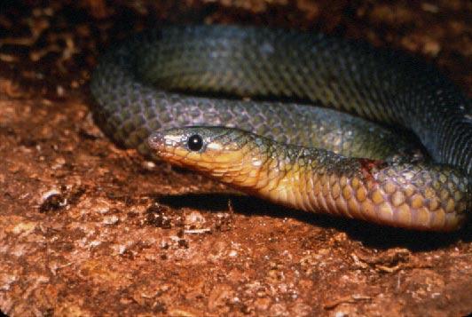
1 Beacon A first report from Kalinga Province in kalinga wildlife By Lawrence R. Heaney, Arvin Diesmos, Blas Tabaranza, Aldrin Mallari, Rafe Brown, and Genevieve Gee Photos by Lawrence R. Heaney, Rafe Brown, and Arvin Diesmos he road from Tueguegarao to the west is not for the faint-hearted. Roughly ten hours on a heavily-rutted, deeply pot-holed, slippery mountain road in a jeepney with almost no springs leaves most people feeling aching and bruised, and if you do not know what to expect on the other end, the day can seem almost endless, and almost without hope. In March 2000, a team led by biologists from THaribon Foundation, the Field Museum of Natural History in Chicago, De La Salle University-Dasmariñas in Cavite, and the University of Texas at Austin, in cooperation with the Department of Environment and Natural Resources, made their way to this remote region of the Philippines to conduct the first-ever survey of its biological diversity. Like most field biologists in the country, we had expected to find denuded mountains populated by impoverished immigrants from more densely populated lowland areas, with the familiar history of commercial logging operations building roads, removing most trees, and opening up access to a flood of kainingeros. As we drove across the Cagayan River valley and into the first foothills, we saw the all-too-familiar muddy rivers, eroded hillsides covered by mud or dust, vast areas of abandoned land covered by cogon grass, and tiny scattered houses; our worst fears seemed to be confirmed. The decade-old satellite photos that we had eagerly examined in Manila, which showed large tracts of old-growth forest and which attracted us here for a few precious weeks of field time, seemed to be a cruel joke. But as we turned a side road and plunged into the heart of the northern Central Cordillera Mountains, through mist-shrouded valleys that grew narrower as the mountains grew steeper, we began to see patches of forest on the high, distant ridges, patches that expanded and slowly came closer to us as we bumped along the miserable road. Cogon lands quickly Left: This insect-eating bat (Otomops sp.) collected in Kalinga Province was previously known only from Java. Opposite page (top): A Philippine burrowing snake was captured under rocks at the edge of the forest near Balbalasang. Bottom (l to r): Our jeepney, on one of the finer sections of the road to Balbalasang; Angle-headed lizard (Bronchocela sp.). 14


2 of Hope the Northern Central Cordillera 15
: Planting rice in a terraced field near Balbalasang. Note that the lowest slopes are shrubby, with the pines starting slightly higher.")


3 Top: Chrotomys whiteheadi, a poorly-known rodent that feeds on earthworms and grubs, known only from the high mountains of the Central Cordillera. Bottom (l to r): Planting rice in a terraced field near Balbalasang. Note that the lowest slopes are shrubby, with the pines starting slightly higher. All of the lower slopes are burned to control rats. The troublesome pests are all accidental imports from mainland Asia, and do not include any of the native species we studied; An apparently previously unknown species of Archboldomys, a small shrew-like rodent that eats only insects and other invertebrates. disappeared, the water in the small river became clear, and houses were congregated into orderly, clean settlements. As the day wore on, our bodies became more bruised, but at the end of the day, our spirits soared. The barangay of Balbalasang, our stopping point and base of operations, lies at about 750 meters elevation in a steep valley beside the Saltan River. Stone terraces that appear to be centuries old define bright green paddies of rice, arcing along the river and extended up along the many side-streams. On the lower hills above the town, huge pine trees tower into the sky, providing a clean image of strength and beauty. The Kalinga people who live here are the descendants of one of the many communities that successfully resisted Spanish domination for 300 years. As part of the Cordillera Autonomous Region, they have retained much of that independence, and so did not hesitate to question us carefully about our motives and methods for conducting biological inventories. After lengthy discussion, they welcomed us into the community, gave us permission to work in their traditional community hunting grounds in the mountains, and helped us to find guides, porters, and the best sites for our work higher in the mountains. Getting to our camp at 1600 meters elevation (about 5000 feet) took a day and a half of rigorous hiking through stately pine forest and beautiful montane rain forest. From the high ridges, we could see mature rain forest extending to the most distant hills the satellite photos had not deceived us after all. It quickly became apparent that we were working in the best-managed forest, with the best-managed wildlife, of any place we had worked in the country; giant hornbills frequently squawked overhead by day, and deer often barked at us by night. Our mammal inventories, which we focused in a single habitat at just one elevation, quickly documented 17 species of mammals, one of 16
: A common but striking bird, the blueheaded fantail (Rhipidura cyaniceps). The trail to our camp was flat in some places, but steep and muddy in others.")


4 Top: One of the new species of frogs we discovered is a ground-living frog (genus Platymantis) that we heard calling all day long at our camp in the forest. Bottom (l to r): A common but striking bird, the blueheaded fantail (Rhipidura cyaniceps). The trail to our camp was flat in some places, but steep and muddy in others. which we suspect is a new species of insect-eating mouse (genus Archboldomys) never before seen by biologists. Information about the ecology of the others added vastly to our knowledge of many poorly-known mammals; most of these occur only in the Central Cordillera, but one was a bat (genus Otomops) previously known from Java, 3000 kilometers away! The ornithologists on the crew tallied 98 species, a remarkable number for such a short time and small sampling area, and the herpetologists on the crew took at least 15 species, including some very poorly known lizards and snakes, and possibly as many as four species of frogs previously unknown to biologists. This astounding level of discovery of new species testi- 17


5 This page (clockwise from top): The Kalinga narrow-mouthed frog Kaloula kalingensis is a poorly-known species, first discovered in Kalinga. We found it living only in tree-holes in the forest; Just above where the road turns into the mountains, the valley of the Saltan River becomes narrow and steep, and rock-faced terraces become apparent; The Luzon jungle-flycatcher Rhinomyias insignis has recently been described as rare, but was one of the most abundant birds near our camp; Part of the field crew enjoying lunch in our rain-forest camp at 1600 m elevation; Platymantis rivularis had not been seen by biologists since it was described in 1922; we found it guarding its eggs in tree-holes near our camp at 1600 meters elevation. fies to the previous lack of knowledge of the area, its high biological diversity, and its potentially high level of biological uniqueness. We have no doubt that this tract of forest is one of the most important biological regions of the country. Perhaps the most surprising finding of all is that the future of the old-growth forests of the northern Central Cordillera in Kalinga and Apayao Provinces seems bright. The especially rugged terrain discourages the logging and mining that have disfigured so much of the mountainous Philippines, and the high rainfall (probably reaching 10 meters per year near the high peaks that reach to about 2400 meters elevation) quickly discourages road-building (as our aching bones attested). More importantly, the residents of the region deserve great credit for their active management of the forests. In addition to resisting outside immigration by kaingineros, they have recognized from long experience that protecting the forest watersheds is essential to their way of life, which centers around the irrigated rice terraces that produce most of their food. The community has not only resisted commercial logging but has enacted laws that severely penalize clearing of community forest land on steep slopes or destructive cutting of trees, and these laws are rigorously enforced at the local level. Moreover, the residents of the Municipality of Balbalan have supported efforts for 18,600 hectares of forested traditional hunting lands to be managed as a national park, so that it can receive the protection of national law as well. We plan to return to Balbalasang again for more field studies during the next few years, in the hope of documenting as much as possible of the exceptionally diverse yet poorly-known fauna. We also will work with the residents, DENR, and other government agencies to develop a management plan for the national park, and to create materials about the fauna that can be distributed to the public, including the eco-tourists now beginning to find their way to the area. And although we plan also to help educate the residents about the fauna of their region, we fully recognize that they, for centuries, have conducted the most successful management of natural resources that we have yet encountered, and have much to teach the rest of us. Lawrence R. Heaney (Field Museum of Natural History in Chicago), Arvin Diesmos (De La Salle University-Dasmariñas), Rafe Brown (University of Texas at Austin) and Haribon Foundation s Blas Tabaranza, Aldrin Mallari, and Genevieve Gee led the team who made the first ever survey of Balbalasang-Balbalan Natural Park. 18
Colorado Life Zone Scavenger Hunt
 Colorado Life Zone Scavenger Hunt Below are worksheets created for all the habitats or life zones. They were designed with the intention of breaking the class up into small groups, and having students
COAST TO COAST RAINFOREST TREK
 COSTA RICA TREK TOUGH ABOUT THE CHALLENGE Our adventurous coast to coast rainforest trek involves crossing from Costa Rica's Pacific Coast to the Caribbean. Enroute we take in the country s highest active
Little Grand Canyon near Pomona, Illinois
 Little Grand Canyon near Pomona, Illinois Below: View of the trail and the terrain created using the Map My Hike app Below: Summary of the hike created using the Map My Hike app Presented by: Jennifer
Allegheny Mountain Cluster
 Allegheny Mountain Cluster Laurel Fork Paddy Lick West Back Creek Mountain The Allegheny Mountain Cluster lies on the backbone of Virginia. Its components are located in the James River and Warm Springs
Elephant. Buffalo. Kudu. Warthog
 ELEPHANT: Loxodonta africana 7000 kg HABITAT: Grasslands, savanna, and woodlands DIET: Herbivore (browser) Leaves and fruits from trees and shrubs. Elephants will knock down trees if they cannot reach
Kirigalpoththa Nature Trail Horton Plains National Park
 Kirigalpoththa Nature Trail Horton Plains National Park Trail Difficulty: Easy Moderate Strenuous Tough Trail Head: Horton Plains Visitor Centre Nearest Town: Pattipola Nearest City: Nanu-Oya Access to
The following criteria were used to identify Benchmark Areas:
 7.0 BENCHMARK AREAS The Churn Creek Protected Area offers a significant opportunity to learn more about how grassland ecosystems function. One of the key tools that will be used to monitor larger grassland
South Texas Plains. Texas, Our Texas
 South Texas Plains This is a region characterized by considerable variety. Climatically, the South Texas Plains region is sub-humid to dry. The in the north part of the South Texas, erosion of the Edwards
ECUADOR: A Case Study. How have humans changed their environment?
 ECUADOR: A Case Study How have humans changed their environment? How have humans changed their environment? Human beings over the course of history have changed their physical surroundings to meet their
4988 +/- ACRES JEFFERSON AND LEON COUNTY, FLORIDA
 4988 +/- ACRES JEFFERSON AND LEON COUNTY, FLORIDA Located in the famed Red Hills of north Florida, El Destino Plantation consists of 4988+/- acres and represents an incredible opportunity to own one of
Eagle Pinon Ranch. 2,963 +/- acres, Hudspeth County
 Eagle Pinon Ranch 2,963 +/- acres, Hudspeth County Eagle Piñon Ranch 2963 acres Hudspeth County, Texas Location The Eagles are part of a chain of sky island mountains that stretch from New Mexico through
The rewards more than make up for the efforts of seeing the country this is a truly unforgettable trek.
 MADAGASCAR TREK ORANGE 2 ABOUT THE CHALLENGE This exciting trek takes us to remote Madagascar, where spectacular scenery and amazing wildlife awaits! From canyons and gorges to bush-covered plains and
Monteverde Tours & Activities 2018
 Monteverde Tours & Activities 2018 Index Monteverde Biological Reserve...3 Horseback Riding...4 Sky Tram, Walk, Trek...5 Hanging Bridges...6 Night Hike Tour...7 Don Juan Trapiche Tour...8 Don Juan Coffee
USDA TRAILS STRATEGY PROGRAM
 USDA TRAILS STRATEGY PROGRAM WRPI Program: English Peak Survey Jorge D. Briceño Southwestern Community College Internship Time Period: June 6, 2016 August 8, 2016 Advisor: Sam Commarto Recreation Officer
Acadia National Park. Waterman Fund Grant Report 2016 Cadillac Mountain South Ridge Trail Rehabilitation. Acadia National Park
 Acadia National Park National Park Service U.S. Department of the Interior Natio n alpar kser vic e U. S. Depar tm en t o f the In ter io r Waterman Fund Grant Report 2016 Cadillac Mountain South Ridge
Potomac Gorge. Resource Booklet. A Natural Monument in the Shadow of National Monuments. Bridging the Watershed. Potomac Gorge 75
 Potomac Gorge Potomac Gorge A Natural Monument in the Shadow of National Monuments Resource Booklet Bridging the Watershed An outreach program of the Alice Ferguson Foundation in partnership with the National
Tambopata Eco Lodge Programs
 Tambopata Eco Lodge Programs Rainforest Experience After your flight to the jungle town of Puerto Maldonado you will be met by our staff, who will escort you during the fascinating three-hour boat trip
Guide to Your Adventure Walk
 Guide to Your Adventure Walk 7 Are you ready to search for some Michigan plants and animals? Grab your backpack, or borrow one from the garden store, and let s get started! On this hike you will see many
2.0 PARK VISION AND ROLES
 2.0 PARK VISION AND ROLES 2.1 Significance in the Protected Area System Marble Range and Edge Hills provincial parks protect 6.8% of the Pavillion Ranges Ecosection, which is located in the Southern Interior
Finca Alto Mirador is located in the foothills above the Caribbean Lowland city of Siquirres. These properties are accessible year-round by a gravel
 Finca Alto Mirador is located in the foothills above the Caribbean Lowland city of Siquirres. These properties are accessible year-round by a gravel road that leads from National Highway 32 (San José to
TAMBOPATA RESEARCH CENTER 7D6N Phoenix Landing Group
 Itinerary TAMBOPATA RESEARCH CENTER 7D6N Phoenix Landing Group DAY 1 / 28 dic 16 Arrival & Reception by Guide Our guides are tourism professionals, or community members. Unless noted otherwise, our guides
Costa Rica. Family Special
 Costa Rica Family Special Itinerary 8 Days 7 Nights Costa Rica Family Special San José Irazu Volcano Cartago Orosi Tapanti National Park Turrialba Sarapiqui La Paz Waterfall Gardens HIGHLIGHTS TOUR ESSENTIALS
Blanco Creek Ranch Acres, Uvalde County, Texas
 Blanco Creek Ranch 1208.30 Acres, Uvalde County, Texas James King, Agent Office 432 426.2024 Cell 432 386.2821 James@KingLandWater.com Blanco Creek Ranch 1208.30 acres Uvalde County, Texas James King,
Prey in the amazon rainforest Nude girls on stickam 10 saal ladki ki xxx Latest news iraqi dinar revaluation
 Prey in the amazon rainforest Nude girls on stickam 10 saal ladki ki xxx Latest news iraqi dinar revaluation 30-1-2018 Amazon unveiled the newest addition to its Seattle campus today three glass and concrete
THE HEUGH LINDISFARNE
 LINDISFARNE COMMUNITY ARCHAEOLOGY THE HEUGH LINDISFARNE Archaeological excavations in June 2017 Invitation to volunteers THE HEUGH, LINDISFARNE, NORTHUMBERLAND: ARCHAEOLOGICAL EXCAVATIONS 2017 INTRODUCTION
Region 1 Piney Woods
 Region 1 Piney Woods Piney Woods 1. This ecoregion is found in East Texas. 2. Climate: average annual rainfall of 36 to 50 inches is fairly uniformly distributed throughout the year, and humidity and temperatures
Marchand Provincial Park. Management Plan
 Marchand Provincial Park Management Plan 2 Marchand Provincial Park Table of Contents 1. Introduction... 3 2. Park History... 3 3. Park Attributes... 4 3.1 Natural... 4 3.2 Recreational... 4 3.3 Additional
Chapter 7. Geography and the Early Settlement of Egypt, Kush, and Canaan
 Chapter 7 Geography and the Early Settlement of Egypt, Kush, and Canaan Chapter 7 Geography and the Early Settlement of Egypt, Kush, and Canaan How did geography affect early in Egypt Kush, and Canaan?
ALBERTA S GRASSLANDS IN CONTEXT
 ALBERTA S GRASSLANDS IN CONTEXT GLOBAL GRASSLANDS 1 Temperate grasslands, located north of the Tropic of Cancer and south of the Tropic of Capricorn, are one of the world s great terrestrial biomes 2.
Grizzly Peak A - East Ridge July 15, 2012
 Grizzly Peak A - East Ridge July 15, 2012 Difficulty: Difficult Class 2/Class 3 Upper Elevation: 13,995 feet Trailhead Elevation: 11,360 feet Elevation Gain: 3,000 feet Round-trip Length: 6.0 miles Trailhead:
Darwin s gigantic blunder
 Trail Darwin s gigantic blunder Explore how ice shaped the landscape and why Charles Darwin made a nice mess of Glen Roy Time: 1hr 10 mins Distance: 2 miles Landscape: rural At Glen Roy a curious feature
glacier _G4U1W5_ indd 1 2/24/10 4:10:48 PM
 glacier Routine for Lesson Vocabulary Introduce This glacier is huge. A glacier is a great mass of ice moving very slowly down a mountain, along a valley, or over a land area. Let s say the word together:
UNIT 5 AFRICA PHYSICAL GEOGRAPHY SG 1 - PART II
 UNIT 5 AFRICA PHYSICAL GEOGRAPHY SG 1 - PART II III. CLIMATE & VEGETATION A. The four main climate zones are tropical wet, tropical wet/dry (split into monsoon & savanna), semiarid, and arid. Other climate
Criddle/Vane Homestead Provincial Park. Management Plan
 Criddle/Vane Homestead Provincial Park Management Plan 2 Criddle/Vane Homestead Provincial Park Table of Contents 1. Introduction... 3 2. Park History.... 3 3. Park Attributes.... 4 3.1 Natural.... 4 3.2
Chapter 7 Geography and the Early Settlement of Egypt, Kush, and Canaan
 Chapter 7 Geography and the Early Settlement of Egypt, Kush, and Canaan How did geography affect early settlement in Egypt, Kush, and Canaan? Section 7.1 - Introduction RF/NASA//Corbis This satellite photograph
The Geological Pacific Northwest. Wednesday February 6, 2012 Pacific Northwest History Mr. Rice
 The Geological Pacific Northwest Wednesday February 6, 2012 Pacific Northwest History Mr. Rice 1 Free Response #2 Please do not simply list the items for this response. Full sentences!!! Minimum of 3-5
Hudson Bay Lowlands Proposed Protected Areas
 Hudson Bay Lowlands Proposed Protected Areas Hudson Bay Lowlands Proposed Protected Areas The Protected Areas Initiative has identified portions of the Hudson Bay Lowlands region that have significant
Subject to sale, withdrawal, or error.
 The Crawford L Bar Ranch is located approximately 40 air miles west of Albuquerque, New Mexico. This ranch truly epitomizes the description of New Mexico being the Land of Enchantment. The topography and
Death Valley Is a Beautiful but Dangerous Place
 Death Valley Is a Beautiful but Dangerous Place Welcome to This Is America with VOA Learning English. Today we visit one of America s great national parks. It is a place of strange and silent beauty. As
beach. Make the ford and follow the trail out to the junction with Red Creek Tr in an open grassy area.
 Description: This is a moderate to slightly strenuous 22.8 mile backpack (add 2.6 miles if you do the packless out and back to the Lion s Head) that will have you exploring nearly every thing that is The
Tours Workshops Activites
 The O MATO Experience 4th 14th September 001 002 003 Tours Workshops Activites 001 Tours 001 2 days; 60 ; 15 p.; 5/5; Tours Waterfall Expedition The by passing Rio Apuau has its source in the very deep
Initiating a Rain Forest Conservation Project in Costa Rica
 Initiating a Rain Forest Conservation Project in Costa Rica When I was in Costa Rica in the summer of 1977 as a graduate student at Harvard University, I became concerned about the future of the La Selva
ROBERTS CREEK PROVINCIAL PARK MASTER PLAN. November, 1981
 Ministry of Lands, Parks and Housing Parks and Outdoor Recreation Division Park Operations Branch North Vancouver, B. C. ROBERTS CREEK PROVINCIAL PARK MASTER PLAN November, 1981 Mr. G. Trachuk Director
At the Lancaster County Environmental Center. Registration Opens March 12, 2018
 2018 Summer Camps At the Lancaster County Environmental Center Registration Opens March 12, 2018 You & Me: Ages 3 & 4 with an Adult Partner Nature Exploration June 12 th & 14 th from 9:00 10:30 a.m. (EC
Mountain Goats and Winter Recreation November 17, 2011
 Mountain Goats and Winter Recreation November 17, 2011 Summary Mountain goats need protection from disruption and displacement in their winter feeding areas by motorized and non-motorized recreationists
Home to mangroves- trees that can grow in saltwater Mangroves provide housing for fish Greater Sundas home to endangered birds and other animals
 Home to mangroves- trees that can grow in saltwater Mangroves provide housing for fish Greater Sundas home to endangered birds and other animals Climate in ecosystem varies-lots of biodiversity Sumatra
Water in the Amazon. By Heather and Georgie
 Water in the Amazon By Heather and Georgie The Amazon is the world s largest tropical rainforest. The Amazon is so big that the U.K and Ireland would fit into it 17 times. The Amazon River It s length
Ice Man Pitch script, UNTV. Written by Ashley E. Williams Arrowhead Films
 Ice Man Pitch script, UNTV Written by Ashley E. Williams Arrowhead Films 1 SCRIPT - SEGMENT #1 VIDEO AUDIO SHOTS OF LEH, PRAYER FLAGS BLOWING IN THE WIND IMPRESSIVE PANORAMIC SHOTS OF LEH NESTLED IN THE
Madagascar Rainforests
 www.natures-images.co.uk 11th to 27th September 2020 Madagascar Rainforests Photographic tour with tour leader Des Ong Itinerary : Days 1-4 Day 1 Friday 11th September Depart UK/Europe for flights to Antananarivo,
Tropical Wildlife llc 739 Lee Dr NM Ph: URL:
 Tropical Wildlife llc 739 Lee Dr NM 87701 Ph: 614 3092936 anita@tropicalwildlife.net URL: www.tropicalwildlife.net ANACONDA ADVENTURE IN THE VENEZUELAN LLANOS Arrival First day: Arrive in the evening at
3.0 EXISTING PARK & RECREATION SPACE
 3.0 EXISTING PARK & RECREATION SPACE TOWN PARK & RECREATION SPACE An inventory of current parks and recreation area in the Town of Cedarburg is shown in Table 3. These areas total roughly 381.89 acres.
The South Gippsland Koala. For over 60 years, the plantation industry has shared a unique relationship with the Strzelecki Koala. protection.
 The South Gippsland Koala For over 60 years, the plantation industry has shared a unique relationship with the Strzelecki Koala. protection harmony THE CO-EXISTENCE OF THE KOALA WITH THE PLANTATIONS co-existence
BISHOPSTONE CIRCULAR WALK
 BISHOPSTONE CIRCULAR WALK 4½ miles (7¼ km) - allow 2 hours (see maps on final pages) Introduction This walk is within the North Wessex Downs Area of Outstanding Natural Beauty and starts from the small,
Route #1) Mt. of the Holy Cross - North Ridge
 Mt. of the Holy Cross - North Ridge") Climbing 14ers can be very dangerous, please read the Mountaineering Safety Page and make sure you have a map+compass and can use them effectively, without the help of electronic devices. Route #1) Mt.
Climbing 14ers can be very dangerous, please read the Mountaineering Safety Page and make sure you have a map+compass and can use them effectively, without the help of electronic devices. Route #1) Mt.
Uganda. Gorilla and Chimpanzee Safari
 Uganda Gorilla and Chimpanzee Safari Itinerary 10 Days 9 Nights Uganda Gorilla and Chimpanzee Safari Entebbe - Kampala - Murchison falls national park - Kibale national park - Queen Elizabeth National
Chapter Objectives. Describe the dominant landforms and natural resources of Southeast Asia. Discuss Southeast Asia s climate and vegetation.
 Chapter Objectives Describe the dominant landforms and natural resources of Southeast Asia. Discuss Southeast Asia s climate and vegetation. The Land Section 1 Objectives Describe how tectonic plates and
Route Combo) Mt. Bierstadt - Bierstadt, Sawtooth, Evans
 Mt. Bierstadt - Bierstadt, Sawtooth, Evans") Climbing 14ers can be very dangerous, please read the Mountaineering Safety Page and make sure you have a map+compass and can use them effectively, without the help of electronic devices. Route Combo)
Climbing 14ers can be very dangerous, please read the Mountaineering Safety Page and make sure you have a map+compass and can use them effectively, without the help of electronic devices. Route Combo)
Rough Haugh Wood Midmar, near Torphins, Aberdeenshire wild acres of undisturbed woodland habitat for 21,000 (freehold) [#A895]
![Rough Haugh Wood Midmar, near Torphins, Aberdeenshire wild acres of undisturbed woodland habitat for 21,000 (freehold) [#A895]](/thumbs/86/93824356.jpg "Rough Haugh Wood Midmar, near Torphins, Aberdeenshire wild acres of undisturbed woodland habitat for 21,000 (freehold) [#A895]") WOODS 4 SALE Phone: 01248 364 362 www.woods4sale.co.uk UK Woodland & Woods For Sale: Specialising in the Sales of Small Woodlands in England, Scotland and Wales for Recreation, Wildlife Conservation and
WOODS 4 SALE Phone: 01248 364 362 www.woods4sale.co.uk UK Woodland & Woods For Sale: Specialising in the Sales of Small Woodlands in England, Scotland and Wales for Recreation, Wildlife Conservation and
Seager Wheeler Lake. Representative Area. -- Concept Management Plan --
 Seager Wheeler Lake Representative Area -- Concept Management Plan -- Saskatchewan Environment and Resource Management January, 1999 Saskatchewan s Representative Areas Network Program The Government of
For more information about trips, itineraries, costs and dates please
 SURVIVING & SUSTAINABILITY - SUMATRA A Science, Humanities & Service Adventure in Central Sumatra For Round Square Conference Delegates (Oct. 9-13, 2015) For more information about trips, itineraries,
Feral Human Expeditions
 Feral Human Expeditions Presents Peru: A Lodge Based Jungle Experience Amazonas, Peru Have you ever wanted to experience the awe inspiring Amazon jungle, but prefer not to sleep in a hammock, cook on a
APPENDIX. Alberta Land Stewardship Act AMENDMENTS TO THE SOUTH SASKATCHEWAN REGIONAL PLAN
 APPENDIX Alberta Land Stewardship Act AMENDMENTS TO THE SOUTH SASKATCHEWAN REGIONAL PLAN 1 All references to Alberta Environment and Sustainable Resource Development, Environment and Sustainable Resource
TRAILS WHERE TO FIND TRAILS IN NOVA SCOTIA
 TRAILs SIGNAGE Know the Signs............................ 44 WHERE YOU CAN RIDE Roads and Highways........................ 46 Designated Trails........................... 47 Established Trails...........................
Human Habitat. Cachuma Lake DISCOVERY BOOK Cachuma Lake Discovery Book V1, Santa Barbara County Parks
 Human Habitat Cachuma Lake DISCOVERY BOOK.0 The Human Habitat People live in houses and buildings to be comfortable and safe. We live together in towns and cities. We build roads to drive our cars from
Hadleigh Castle and Chalkwell Oaze
 1 Hadleigh Castle and Chalkwell Oaze Benfleet station Hadleigh Park Hadleigh Castle Leigh-on-Sea Chalkwell station A short stroll through the lush woods of Hadleigh Park high above the Thames-side marshes,
The Chippewas of Georgina Island First Nation At A Glimpse
 Located in Lake Simcoe approximately100 km north of the Greater Toronto Area (GTA) in Ontario Canada. Consisting of 3 separate Islands, Georgina, Snake and Fox with 2 mainland access points.. Georgina
Frazier Canyon Ranch 3,020 Acres Jeff Davis County, Texas
 Frazier Canyon Ranch 3,020 Acres Jeff Davis County, Texas James King, Agent Office 432 426.2024 Cell 432 386.2821 James@KingLandWater.com Frazier Canyon Ranch 3,020 acres Jeff Davis County, Texas James
Wednesday, April 4, 2018
 Wednesday, April 4, 2018 Physical Geography of Japan Objective: Outline the countries and territories that are included in East Asia. Describe the main physical features and climate types of each country.
Long Canyon Ranch /- acres Terrell County, Texas. James King, Agent Office Cell
 KING LAND & WATER Protecting Clients. Conserving the Land. Long Canyon Ranch 4797 +/- acres Terrell County, Texas James King, Agent Office 432-426-2024 Cell 432-386-2821 James@KingLandWater.com King Land
A topographic map shows:,,,,
 Name: Period: Mapping the Earth Notes What is a map? Label the compass directions: What does latitude measure? What is the name of the 0 latitude line? Where is 90 north latitude? Where is 90 south latitude?
GOLDEN EARS PROVINCIAL PARK
 GOLDEN EARS PROVINCIAL PARK Trail Information as of October 10 th 2015 Do not underestimate the mountainous wilderness of Golden Ears Provincial Park. The combination of rugged terrain and rapidly changing
Provincial Development and Physical Framework Plan Province of Capiz
 3.2.3 Protection Areas Protection areas (Map 11) which include areas under the categories of NIPAS, Non-NIPAS, environmentally constrained and the military reservations are described as follows: a) NIPAS
County Line trail - Miller Peak to Little Navaho
 County Line trail - Miller Peak to Little Navaho 7-17-2008 This hike features a portion of the County Line trail in the Teanaway that receives extremely little use despite offering a spectacular ridge-run
Mount Meru Hiking / Climb
 Mount Meru Hiking / Climb Mount Meru is the second highest mountain in Tanzania and the fifth highest in Africa. Mount Meru is an active volcano located 70 kilometres (44 miles) west of Mount Kilimanjaro.
What Is An Ecoregion?
 Ecoregions of Texas What Is An Ecoregion? Ecoregion a major ecosystem with distinctive geography, characteristic plants and animals, and ecosystems that receives uniform solar radiation and moisture Sometimes
The Uphill Climb: Mountain Goat-Human Interactions on the Olympic National Forest. Kurt Aluzas Wildlife Biologist Enterprise Program
 The Uphill Climb: Mountain Goat-Human Interactions on the Olympic National Forest Kurt Aluzas Wildlife Biologist Enterprise Program An example of challenges involving recreating public and wildlife Wildlife
Mills Pecos River Ranch 7800 Acres Val Verde County, Texas Situated along both sides of the Pecos River
 Mills Pecos River Ranch 7800 Acres Val Verde County, Texas Situated along both sides of the Pecos River James King, Agent Office 432-426-2024 Cell 432-386-2821 James@KingLandWater.com King Land & Water
The Fauna. Of The Central Balkan
 The Fauna Of The Central Balkan The diverse relief, vegetation and microclimate of the Central Balkan National Park determine the high diversity of the fauna. The territory of the park shelters 70% of
SRI LANKA. Diverse Travel Limited Sri Lanka Wildlife & Nature
 SRI LANKA Diverse Travel Limited Sri Lanka Wildlife & Nature 7 nights Sri Lanka Holiday Sri Lanka is a lush, tropical island paradise, known to Arab traders as Serendib hence "serendipity", meaning discovery
MANAGEMENT DIRECTION STATEMENT June, 1999
 Thompson River District MANAGEMENT DIRECTION STATEMENT June, 1999 for Clearwater River Corridor (Addition to Wells Gray Park) Ministry of Environment Lands and Parks BC Parks Division ii Table of Contents
Dixon Trail Construction - From the Top of the Mountain 2016 Interim Report Friends of Cheyenne Mountain State Park September 2 nd, 2016
 - Dixon Trail Construction - From the Top of the Mountain 2016 Interim Report Friends of Cheyenne Mountain State Park September 2 nd, 2016 Prepared by: Andy Riter, Program Coordinator, and Joe Lavorini,
Green Legacy. Securing our. Greenlands Strategy
 Greenlands Strategy Securing our Green Legacy Together we can create an interconnected network of Greenlands for the health and well-being of the environment and future generations Caring for the Credit
IOWA ORNITHOLOGISTS' UNION - Birding Sites in Dallas County
 IOWA ORNITHOLOGISTS' UNION - Birding Sites in Dallas County Printed on 7/19/2018 Beaver Bottoms Wetland (restricted) (Important Bird Area) GPS Coordinates:, Ownership: Private (see directions for access)
POSTCARD FROM EL YUNQUE, PUERTO RICO
 POSTCARD FROM EL YUNQUE, PUERTO RICO This is our lovely Frog Lady guide who drove us southeast of San Juan to El Yunque, the only tropical rain forest in the US National Forest Service. It has had three
Sapa, Vietnam. Words by Adam Horler photos Andrew J Loiterton film by Jon Moore. Sapa
 Sapa, Vietnam Words by Adam Horler photos Andrew J Loiterton film by Jon Moore To the outside world, Vietnam is associated with many things; years of war, endless rice fields, exceptional cuisine. What
FOOD!WEBS!ACTIVITY:!BUILDING!A!FOOD!CHAIN!
 STUDENTWORKSHEET INTRODUCTION FOODWEBSACTIVITY:BUILDINGAFOODCHAIN Afood$chainisasimplemodelthatidentifiesthefeedingrelationshipsandtheflowofenergyinan ecosystem.whilethesunisthesourceofenergyinthesystem,plants(producers)convertthatenergy
Brain Wrinkles. Africa: The impact of location, climate, & physical characteristics on where people live, the type of work they do, & how they travel
 Africa: The impact of location, climate, & physical characteristics on where people live, the type of work they do, & how they travel STANDARDS: SS7G3 The student will explain the impact of location, climate,
A GIS Analysis of Probable High Recreation Use Areas in Three Sisters Wilderness Deschutes and Willamette National Forests
 Lindsey Kiesz Geo 565 Term Project 3/15/2010 A GIS Analysis of Probable High Recreation Use Areas in Three Sisters Wilderness Deschutes and Willamette National Forests Introduction The Three Sisters Wilderness
Criddle/Vane Homestead Provincial Park. Draft Management Plan
 Criddle/Vane Homestead Provincial Park Draft Management Plan 2 Criddle/Vane Homestead Provincial Park Table of Contents 1. Introduction... 3 2. Park History.... 3 3. Park Attributes.... 3 3.1 Natural....
BIG ANIMALS and SMALL PARKS: Implications of Wildlife Distribution and Movements for Expansion of Nahanni National Park Reserve. John L.
 BIG ANIMALS and SMALL PARKS: Implications of Wildlife Distribution and Movements for Expansion of Nahanni National Park Reserve John L. Weaver Conservation Report No.1 July 2006 4 SUMMARY The boundaries
You can learn more about the trail camera project and help identify animals at WildCam Gorongosa (
 INTRODUCTION Gorongosa National Park is a 1,570-square-mile protected area in Mozambique. After several decades of war devastated Gorongosa s wildlife populations, park scientists and conservation managers
GEOGRAPHY AND HISTORY
 GEOGRAPHY AND HISTORY YEAR 1, PART 1 www.vicensvives.es Contents 01 Our planet Earth 02 The representation of the Earth: maps 03 The Earth s relief 04 Rivers and seas 05 Weather and climate 06 Climates
Stagecoach Ridge Ranch 1266 Acres, Alpine, Brewster County James King, Agent Office Cell
 Stagecoach Ridge Ranch 1266 Acres, Alpine, Brewster County James King, Agent Office 432-426-2024 Cell 432-386-2821 James@KingLandWater.com King Land & Water LLC P.O. Box 109, 600 State Street, Fort Davis,
BILL S-210: A REASONABLE STATUTORY FRAMEWORK TO PROTECT GATINEAU PARK
 BILL S-210: A REASONABLE STATUTORY FRAMEWORK TO PROTECT GATINEAU PARK BRIEF SUBMITTED TO THE SENATE STANDING COMMITTEE ON ENERGY, THE ENVIRONMENT AND NATURAL RESOURCES MARCH 27, 2007 Stephen Hazell Executive
Stein Valley Nlaka pamux Heritage Park
 Stein Valley Nlaka pamux Heritage Park - Trail Information Update and Winter Advisory November 2017 March 2018 Welcome to Stein Valley Nlaka pamux Heritage Park! **This trail update is to inform park users
Mobile Safari Laikipia to Western Kenya 10 Nights
 Mobile Safari Laikipia to Western Kenya 10 Nights This is a private guided safari led by Steve Carey or another highly experienced guide. The safari is by road in a custom-made Toyota Landcruiser focusing
ONTARIO TRAILS COUNCIL FAQ
 Trail Facts Ontario has some of the most treasured and protected outdoor areas in the world with: 329 Provincial Parks 400 Conservation Areas 292 Conservation Reserves Many people link trails with recreation
Significant Natural Area Assessment. Property Name: Hillend Station
 Private Bag 50072, Queenstown 9348, New Zealand QUEENSTOWN, 10 Gorge Road, Phone +64 3 441 0499, Fax +64 3 450 2223 WANAKA, 47 Ardmore Street, Phone +64 3 443 0024, Fax +64 3 450 2223 Significant Natural
Monitoring the Environmental Status of the Heart of Borneo
 Monitoring the Environmental Status of the Heart of Borneo By: Stephan Wulffraat The Heart of Borneo conservation initiative has been going on now for several years and has gained increasing support from
Inca Trail Expedition. $ 785 USD per person 5D/4N
 Inca Trail Expedition $ 785 USD per person 5D/4N Day 1: Cusco Ollantaytambo KM 82 Hatunchaca We will depart from Cusco at 5 a.m. in a private transport and head toward KM 82, the starting point of the