Preliminary Findings Report
|
|
|
- Helen Rich
- 6 years ago
- Views:
Transcription

1 parkscanada.gc.ca Preliminary Findings Report for the assessment of national park reserve lands on Bowen Island August 2011
2 Front cover image credit: Ivan Grabovac
3 Executive Summary In 2009, Bowen Island Municipality (BIM) approached Parks Canada with a request to consider lands on Bowen Island for the creation of a national park. In May 2010, in collaboration with the BIM, and in partnership with the Province of British Columbia, Parks Canada agreed to lead a feasibility assessment to study the potential for national park reserve lands on Bowen Island. The feasibility assessment is a process, which includes consultations to determine whether establishing national park reserve lands on Bowen Island is practical and desirable. One of the core products is a park concept, which indicates the area of interest and a conceptual outline on how national park reserve lands would be operated and managed. The assessment does not determine whether a park reserve will be established, but identifies the scope of the park proposal in addition to its associated opportunities and challenges. During the process several questions will be answered, including: Do the resources of Bowen Island meet Parks Canada s criteria for national park reserve lands? Is there sufficient potential for memorable visitor experiences? Is there sufficient community and Aboriginal support? This report, serves as the foundation for building the park concept. It summarizes the results of the feasibility assessment process to date, including an overview of consultations and summaries of the economic and social impact assessment findings. In addition, the land analysis provides an initial overview of each of the areas of interest, operational considerations are noted, and the report concludes with recommendations to revise the Preliminary Park Concept. The recommendations are as follows: Demonstrate how ideas and considerations are addressed through all stages of the establishment process: feasibility assessment, negotiations, establishment, interim management planning and management planning. Provide examples from Gulf Islands National Park Reserve to illustrate content in the park concept. Modify the areas under consideration in the Revised Park Concept: o Remove David Otter Nature Reserve and Bluewater Crown Shoreline Reserve; o Add Lieben, including a 25m marine area of interest; o Expand the land considered in Block 6 Radar Hill; o Reduce the marine area of interest inside the mouth of Snug Cove from 200m to 25m, but extend the 25m area further into the cove; and o Add 25m of marine area in front of Crippen in Deep Bay. o Expand the marine area of interest off the Mount Gardner Block. Clarify the following musts for Parks Canada: o Crippen is an essential component of potential national park reserve lands on Bowen Island. o National park reserve lands would be part of Gulf Islands National Park Reserve. o An advisory board for Bowen Island would be established to ensure local consideration of issues for national park reserve lands on Bowen Island. If there is support for the concept of a national park reserve, and if the governments of British Columbia and Canada decide to move ahead to the next step, it would simply mean the proposal is ready to move forward to negotiations. The establishment process and its steps are explained below. Canada and British Columbia recognize the importance of support from the Municipality of Bowen Island and First Nations for a national park reserve on Bowen Island. Canada and British Columbia have pledged to collaborate with all governments on the feasibility of the park proposal prior to any decision to move i
4 forward with negotiations on establishment. Once the feasibility assessment process is complete, a submission will be made to the provincial and federal governments. If it is determined that national park reserve lands are feasible, then governments may decide to proceed with the negotiation of a park agreement. ii
5 Table of Contents 1. INTRODUCTION... 1 Context Why Bowen Island?... 1 Purpose of the Preliminary Findings Report... 2 Feasibility Assessment: the First Step in the Establishment Process PARK CONCEPT PARKS CANADA S CONSULTATION PROCESS... 5 Overview of Public Consultations: August 2010 to April Information Sessions (Phase I)... 6 Vision and Concept Development (Phase II)... 7 Preliminary Park Concept (Phase III)... 8 Stakeholder Consultations BOWEN ISLAND MUNICIPALITY CONSULTATIONS Bowen Island Municipality Sessions National Park Community Advisory Committee Telephone Opinion Survey FIRST NATIONS CONTEXT AND CONSULTATIONS Context Consultations DISCUSSIONS WITH LAND MANAGEMENT AGENCIES British Columbia Metro Vancouver Islands Trust Fund Bowen Island Municipality ECONOMIC IMPACT ASSESSMENT Community Profile Preliminary Park Concept Visitor Opportunities and Infrastructure Parks Canada s Investment Park Visitation Forecast Effects on Bowen Island SOCIAL IMPACT ASSESSMENT Assessment Summary Social Effects AREAS OF INTEREST: ANALYSIS Context Areas of Interest Analysis of Potential National Park Reserve Lands and Waters Bowen Island Municipal Park Lands: Quarry Park and Davies Creek Corridor Parks Bowen Island Municipal Park Lands: Seymour Landing Crown Shoreline Reserve: Bluewater Islands Trust Fund: David Otter Nature Reserve PARKS CANADA CONSIDERATIONS Areas of Interest iii
6 Private Property Acquisition Crippen Regional Park Marine Areas of Interest Park Management One Park Not Two Local Advisory Body First Nations Considerations Treaty Claims RECOMMENDATIONS FOR THE REVISED PARK CONCEPT Recommendations NEXT STEPS Your Input is Invited REFERENCES APPENDICES A. Summary of Public Consultations and Outreach Activities Organized and/or Attended by Parks Canada staff B. Overview of Communication Products C. List of Workshop Attendees D. Overview of Stakeholder Consultation E. Parks Canada Response to BIM Land Recommendations F. Marine Areas Submitted to Parks Canada for Consideration iv
7 1. INTRODUCTION Parks Canada and the Government of British Columbia, in cooperation with the Bowen Island Municipality (BIM), are exploring the possibility of establishing national park reserve lands on Bowen Island through a feasibility assessment. The assessment is a process, which includes consultations to determine whether establishing national park reserve lands on Bowen Island is practical and desirable. The assessment will answer many questions, including: Do the resources of Bowen Island meet Parks Canada s criteria for national park reserve lands? Is there sufficient potential for memorable visitor experiences? Is there sufficient community and Aboriginal support? The feasibility assessment does not determine whether national park reserve lands will be established, but identifies the scope of the park proposal in addition to the opportunities and challenges associated with the proposal. Context Why Bowen Island? In 2009, BIM approached Parks Canada with a request to consider lands on Bowen Island for the creation of a national park. A preliminary analysis of potential opportunities was undertaken over the winter of 2009/2010. In May 2010, in collaboration with BIM, and in partnership with the Province of British Columbia, Parks Canada agreed to lead a feasibility assessment to study the potential for national park reserve lands on Bowen Island. Parks Canada agreed to lead the feasibility study because, if established, national park lands on Bowen Island would contribute to the Agency s goals to better connect with urban residents in the Metro Vancouver region and increase access to Parks Canada experiences, connecting new generations of Canadians to conservation, natural heritage and environmental education through hands-on experiences and outreach activities. National park reserve lands on Bowen would also greatly enhance the ecological and geological representation of the Strait of Georgia Lowlands natural region. 1
8 Purpose of the Preliminary Findings Report This report is a summary of the feasibility assessment process to date. It includes: Introduction to the park concept; Overview of consultations led by Parks Canada; Overview of Bowen Island Municipality s consultation approaches and research; Background on First Nations context and consultations; Summary of initial discussions with land management agencies; Overview of the Economic Impact Assessment results; Overview of the Social Impact Assessment results; Initial analysis of lands being considered; Operational considerations for Parks Canada; and Recommendations for revisions to the park concept. Canada and British Columbia recognize the importance of support from the Municipality of Bowen Island and First Nations for a national park reserve on Bowen Island. Canada and British Columbia have pledged to collaborate with all governments on the feasibility of the park proposal. Once the feasibility assessment process is complete, a submission will be made to provincial and federal governments. If it is determined that national park reserve lands are feasible, then governments may decide to proceed with the negotiation of a park agreement. 2
9 Feasibility Assessment: the First Step in the Establishment Process If governments move from the feasibility assessment to the next step, there is no guarantee that national park reserve lands will be established. It would simply mean the proposal is ready to move to the next step in the process: negotiations. The steps of the establishment process are explained below. Feasibility Assessment STOP Negotiation Establishment Feasibility Assessment. A process with extensive consultation to determine whether establishing national park reserve lands on Bowen Island is practical and desirable. The feasibility assessment does not determine whether park reserve lands will be established, but identifies the scope of the park proposal and its associated opportunities and challenges. The feasibility assessment includes the development of a park concept, as well as consultation with First Nations, local and regional governments, stakeholders and the public. If this assessment shows that national park reserve lands are feasible and there is support, governments may decide to proceed with negotiation of a park agreement. Otherwise, the proposal will go no further. Negotiation. A process that takes place primarily between the provincial and federal governments. During negotiations, the governments determine whether the park concept can be implemented, and whether concerns raised during the feasibility assessment can be overcome. If successful, negotiations can result in a formal agreement to establish national park reserve lands on Bowen Island. Otherwise, the proposal will go no further. Establishment. A decision made by the governments of British Columbia and Canada on whether the proposed lands should be scheduled under the Canada National Parks Act. If the decision is made to not establish national park reserve lands, the proposal will go no further. Interim Management Plan Management Plan Interim Management Plan. A short-term set of guidelines that provide a basis for managing park reserve lands during the first five years of operation. They are developed through consultation with partners, stakeholders and the public. These interim guidelines are intended to direct management and operations in the short term, addressing the immediate conflicts between protection and use and between uses. The guidelines also direct the inventory and assessment of resources and use in preparation for long-term decisionmaking. Management Plan. A strategic long-term guide for the future management of national park reserve lands and waters. The plan is required by legislation and its development is guided by public consultation. The primary goal is to ensure that there is clearly defined direction for the maintenance, restoration, and appropriate use of national park reserve lands and waters. The management plan is reviewed and if needed, revised every five years. In addition, annual reporting is part of the planning cycle. 3
10 2. PARK CONCEPT The Revised Park Concept is a companion document to this report. Feedback from consultations, public opinion research and an initial review of tenures helped shape revisions to the Preliminary Park Concept presented on February 26, The Revised Park Concept includes revisions to the areas of interest and information on how they would be operated and managed. The concept includes examples of how key opportunities and concerns identified by the community could be addressed if national park reserve lands were to be established, and how such issues would be addressed at each step in the process from feasibility through to management planning. The park concept is not intended to be a detailed plan, since many factors can only be resolved through negotiations with different levels of government. If deemed feasible, and if agreement is reached to establish national park reserve lands, a subsequent interim management planning process will take place, with public and First Nations consultation. 4
11 3. PARKS CANADA S CONSULTATION PROCESS The consultation and communications program supporting the feasibility assessment for national park reserve lands on Bowen Island began in August This section describes Parks Canada s efforts. The outreach and consultation program led by BIM is addressed in a later section. Parks Canada has met with residents, stakeholders and interested Canadians to learn about interests and concerns, to share information, and to answer questions. The goal has been to develop a concept of what national park reserve lands could look like on Bowen Island, and gauge whether there is support for the concept. The public consultation program for the feasibility assessment was developed in cooperation with BIM and British Columbia. It has included public information sessions, open houses, workshops, meetings stakeholders, and outreach activities. Input and comments received throughout the process have been integral to the development and refinement of the park concept. In August and September 2011, more Parks Canada consultation and outreach events are planned one to present the revised park concept on Bowen Island, and one in West Vancouver. Parks Canada staff will also have an information booth at Bowfest and will present the concept to BIM Council. Overview of Public Consultations: August 2010 to April 2011 Parks Canada s public consultation program for the feasibility assessment has involved consultation events at each of the key steps of the process. Between the summer of 2010 and the spring of 2011 there have been eight information sessions, two workshops, an inter-island tour, and six outreach events to communicate with Bowen Islanders and West and North Vancouver communities. These events were attended by over 1,750 people (Appendix A). In addition, a series of communication products were developed to provide information to the public about the feasibility assessment. These included a website, info sheets, letters in the Bowen Island Undercurrent and reports (Appendix B). Input was sought at each of the feasibility assessment s key milestones: Introduction to the process (Phase I); Development of a park vision and park concept (Phase II); and Presentation of the Preliminary Park Concept (Phase III). The feasibility assessment is currently in the final public stage, Phase IV, refinement of the park concept. 5

12 Information Sessions (Phase I) The information sessions held on Bowen Island and in North and West Vancouver, in August and September 2010, marked the beginning of the consultation process. Their purpose was to: 1. Introduce the Bowen Island feasibility assessment; 2. Introduce Parks Canada s mandate and the national parks system; 3. Provide opportunities for participants to learn about the feasibility assessment process and how they can be involved; 4. Seek feedback to identify key concerns and opportunities; and 5. Identify subject areas for further clarification. Comments from the information sessions, conversations, feedback forms and helped identify opportunities and concerns (Table 1). Comments indicated a range of perspectives both for and against the establishment of a national park reserve lands on Bowen Island (Figure 1). People identified educational opportunities and protection of the land as the two greatest opportunities. Key concerns related to increased ferry traffic, increased costs, and impacts to transportation. Many people also indicated that Cape Roger Curtis should be included in the area of interest. Table 1. Submissions in Phase I Method Received Feedback form 53 Comment board 15 s/letters 27 TOTAL 95 Figure 1. Summary of Opportunities and Concerns Based on Relative Frequency Opportunities Concerns * 54 postcards requesting the inclusion of Cape Roger Curtis were submitted to M.P. John Weston and Parks Canada. These are denoted in orange under Area of Interest. 6
13 Vision and Concept Development (Phase II) The second phase of the feasibility assessment ran from October 2010 to January The focus was on the development of the vision and concept. This phase included workshops and an open house. The Visioning Workshop on November 3, 2010, included participants who were invited by the Bowen Island Municipality and Parks Canada to represent on-island and off-island interests (Appendix C). The list included representatives from 14 different island organizations, in addition to 5 individuals. Twenty of the 27 invitees attended the workshop. Approximately 15 to 20 members of the public also attended to observe the workshop. Participants developed themes and ideas related to Bowen Island, which were then used to create a draft vision that reflected participant input and the mandate of Parks Canada. The key themes for the vision were: Protection of natural and cultural heritage; Sustainable, low-impact activities and educational programs; Respect for the special character and community values of Bowen Island; and Positive working relationships based on cooperation. The Concepts Workshop on November 27, 2010, invited back the same groups and individuals from the Visioning Workshop, with the addition of one more on-island group (Appendix C). Twenty of the 28 invitees attended the workshop. The workshop provided opportunities for participants, working in five groups, to review the draft vision, and to develop ideas of what the national park reserve lands could look like. Participants elaborated on Parks Canada s values and priorities analysis to highlight additional ecological, recreational, educational and cultural values. Management and community constraints were also noted. In addition, each of the groups developed ideas for a park concept that indicated important areas and activities. These were recorded on maps and in notes. Although each of the five draft concept options was different, there were a number of themes common to several groups: Include all Crown lands, except those required for community needs. Include some marine areas adjacent to lands of interest. Enhance opportunities for improved ecological and trail connectivity among lands of interest. Enhance watershed protection. Exclude most or all municipal parks and beaches. Consider the potential of some private land to complement the role of public lands. Consider the option of alternative access via Seymour Bay. Consider private lands (Cape Roger Curtis). Consider the inclusion of Lieben. Consider marine areas adjacent to private land. Diverse opinions on the inclusion of Crippen Regional Park: o o o o Two groups included it; One group included it, but excluded a small portion for Snug Cove development and ferry marshalling; One group noted it as an area of special public interest, and noted that a management agreement should be in place prior to inclusion being considered, in addition this group excluded the meadow and access; and Another group indicated Crippen should remain with Metro Vancouver. 7
14 At the Vision and Concepts Open House on November 27, 2010, the public had a chance to review the draft vision; learn about Parks Canada values and priorities; comment on the various draft park concept options developed in the concepts workshop; and propose guidelines for potential activities. The feedback received at the open house was instrumental in helping Parks Canada refine the vision and develop the Preliminary Park Concept. Highlights of the feedback include: Park Concept Options: o Support for a seaview and bluff trail; o Desire to include Cape Roger Curtis and marine areas; and o Support for sustainable living values and education. Draft Vision: o Include off-leash dog walking; o Include international visitors; and o Add rural island character. Park Activities and Management: o Include backcountry camping (including kayak access); o Protect forests; and o Do not embrace RVs and jet skis. Preliminary Park Concept (Phase III) The third phase of consultations, from February to March 2011, focused on the Preliminary Park Concept. An information session on Bowen Island and one in West Vancouver saw 190 people attend to hear more about what national park reserve lands could look like. Parks Canada gave a presentation to explain what lands were being considered, and how they could be operated and managed. The questions asked at the information session, and submitted comments ( submissions, and letter and fax - 36 submissions) were analyzed and categorized according to themes. The most common topics included: 1. Park Concept Support and opposition for park concept: o Protection of Bowen lands; o No need for further protection or another level of governance; and o Partial support, if certain conditions are met. Requests for more detail. 2. Park Concept Area Boundary: o Many comments supported the boundary, others rejected it outright; o Suggestions for a larger area, others for a smaller area; o Include Lieben; o Exclude David Otter Nature Reserve; o Exclude municipal surplus lands; o Strive for connections between park lands; and o Concern about management of park lands that are adjacent to private property. Marine Areas o Many comments supported protection of marine areas; o Need for more detail, consult with marine experts; and o Some concerns about marine areas in front of private land. Crippen Regional Park o Comments supporting both the inclusion and exclusion of Crippen; and o Some indicated partial support if certain conditions are met (primarily addressing dogs off-leash and fees). 8
15 3. Transportation Concerns and Solutions Need concrete solutions for increased ferry usage: o Need for adequate ferry marshalling area; o Need for adequate parking; and Support for car-free or walk-on visits. In addition to submissions from individuals and groups, a petition objecting to the inclusion of Crippen Regional Park was submitted to Parks Canada on March 27, The petition had 966 signatures. On March 31, 2011, petition organizers announced that they had over 1,000 signatures, representing approximately one third of the Bowen Island community. The petition notes that those who signed their name object to the Federal Government and Parks Canada taking over control and regulation of Crippen Park. Stakeholder Consultations Throughout the feasibility assessment, Parks Canada has met with the BIM s National Park Council Committee (NPCC) and the Government of British Columbia to plan and design the process of consultations and activities. Parks Canada made several presentations at BIM Council meetings, in addition to attending other sessions to hear submissions from other committees and groups. Parks Canada also attended several meetings and events arranged by the National Park Community Advisory Committee. Parks Canada has met with a number of stakeholders and government land management agencies to discuss the feasibility assessment and various topics of interest and concern (Appendix D). In the period from August 2010 to April 2011, these groups have included: the Government of British Columbia, BC Ferries, Metro Vancouver Parks (staff, Board and CAO), the Bowen Island RCMP detachment, some property owners (including a representative from Cape Roger Curtis) and non-government organizations, such as the Bowen Island Fish and Wildlife Club, and individuals and organizations on marine issues. Further details on discussions with land management agencies can be found in section 6. 9
16 4. BOWEN ISLAND MUNICIPALITY CONSULTATIONS Bowen Island Municipality led a parallel program of consultations and outreach to better understand the key issues and provide opportunities for community members to share information and learn more about the proposal. These activities included the Inter-Island Mission to Gulf Islands National Park Reserve and open house presentation to the community, two community-led open space forums, the formation of a National Park Community Advisory Committee, a telephone opinion survey, as well as several Council meetings that included discussions on the feasibility assessment. Bowen Island Municipality Sessions At the Inter-Island Mission open house (September 2010), community members of the Inter-Island delegation presented their findings and recommendations from their visit to Gulf Islands National Park Reserve. At this session, Parks Canada delivered a presentation about the establishment and management of Gulf Islands National Park Reserve. A delegation of eight community members, the Bowen Island Mayor and four Councillors went to see the national park and learn first-hand from local residents about their experiences. The delegation was hosted by Parks Canada staff. Time was divided between meeting with Gulf Islanders, the two National Park Liaison Committees and visiting park lands and facilities. The recommendations of participants were to proceed with caution and continue with the feasibility assessment process and to carry-out further consultative and cooperative activities. BIM hosted an open space session on October 16, 2010, to learn about community concerns and opportunities. Participants self-identified topics of interest and participated in discussions on those subjects. A range of topics were discussed, including negotiation, governance, transportation, future legacy, park rules, economy and many more. In addition, a second open space session was held, focussing on Crippen Regional Park. Participants joined groups and topics of interest, asked questions, and brainstormed ideas and suggestions on a range of topics, including community land needs for Snug Cove, partnerships with and licenses of occupation for existing societies and organizations, the importance of Crippen to the community and keeping Crippen a regional park. National Park Community Advisory Committee The National Park Community Advisory Committee was formed in November Its over 30 members informed and engaged the Bowen Island community about the national park reserve feasibility assessment. The Committee advised the BIM Council on the concerns, interests and opportunities of Bowen Islanders. The Committee shared information about the feasibility assessment and used various methods to reach out to community members including an on-line survey, outreach programs on the ferry, at the general store, with community groups, and public seminar events amongst others. Their findings and recommendations are presented in the Bowen Island National Park Reserve Community Consultation Report. 10
17 Telephone Opinion Survey A telephone survey of Bowen Island residents was conducted by McAllister Opinion Research from March 4-9, 2011, to learn about local perspectives on the feasibility assessment. Questions related to familiarity with the proposal, opinions, perspectives on Crippen Park and perception of potential impacts and benefits. Key findings from the survey indicated the following: Using random digit dial, the company interviewed 300 residents with listed and unlisted phone numbers. The margin of error is + 5.3%, with a 95% confidence level. 1. Residents were still looking for more information: 39% undecided, 34% in favour, 25% opposed to the concept of a national park. 2. Top benefits are environmental, economic and social: Protection of land and marine ecosystems, Strengthening the local economy, and Improvement of outdoor recreational facilities. 3. Top concerns are local control, the ferry and community: Loss of local control over decisions on land use, Impacts on the ferry service / traffic / transportation, and Impacts on local way of life/community character. 4. Bowen residents want planning, control and benefits: A plan for managing ferry capacity and service, Mechanisms for local governance, and Improved recreational facilities/trail system. The survey also asked respondents for their thoughts on the inclusion of Crippen Regional Park in the proposed national park reserve lands. The results were 34% opposed; 32% supportive; 30% undecided and 3% of respondents answered with it depends. For more details, refer to the report Local Perspectives on the Proposed National Park Reserve by McAllister Opinion Research. 11
18 5. FIRST NATIONS CONTEXT AND CONSULTATIONS Context The Squamish Nation and the Hul qumi num Treaty Group both entered the treaty process in the early 1990s. As part of the treaty process, the Squamish Nation identified the lands on Bowen Island, while the Hul qumi num Treaty Group identified the waters around Bowen Island, as part of their respective traditional territories. Treaty negotiations are facilitated through the British Columbia Treaty Commission. More information about the treaty process can be found on the British Columbia Treaty Commission s website at Consultations Parks Canada has had initial discussions with representatives of the Squamish Nation, and the liaison committee of the Hul qumi num Treaty Group, to present the feasibility assessment process and seek input on the proposal, and to better understand interests as they relate to the lands and water under evaluation for a national park reserve. Discussions are at an early stage, and community meetings have yet to be held. The focus is on building positive, respectful and collaborative working relationships. In addition to the legal obligation the government of Canada has to consult with Aboriginal peoples, Parks Canada has corporate objectives to build and maintain relationships with Aboriginal peoples and to increase the Aboriginal voice in all aspects of park and site management. Across Canada, there are many examples of Parks Canada and Aboriginal peoples working together toward common interests. For example: Gulf Islands National Park Reserve has worked closely with First Nations partners to share Coast Salish traditions and contemporary connections to the land through engaging stories and images in visitor publications and interpretive signage. This summer, Gulf Island National Park Reserve will host an Art in the Park program for Coast Salish artists to demonstrate carving, drumming and storytelling at special events being planned to celebrate Parks Canada s 100 th anniversary in
19 6. DISCUSSIONS WITH LAND MANAGEMENT AGENCIES The areas of interest identified in the Revised Park Concept include lands owned and managed by different levels of government: British Columbia, Islands Trust Fund, BIM and Metro Vancouver. Potential acquisition of any lands or portions of lands, managed by these landowners is dependent on if there is support for the concept of a national park reserve. The details of what lands, how much and under want conditions would be decided in negotiations. To date, discussions with the government land owners and managers have focussed on the process. British Columbia The Government of British Columbia is a partner in the feasibility assessment process. They are represented on a Canada-British Columbia Steering Committee, and participate in regular discussions on the process and next steps. British Columbia is leading discussions with BC Ferries in regards to the implications on ferry service in regards to the park concept. Metro Vancouver As the proposal includes Crippen Regional Park, Parks Canada had a series of meetings with Metro Vancouver Parks staff (August 2010, September 2010, and January 2011), including a field trip where staff provided background information on the facilities, services and third party agreements they have in place. In addition, a presentation was made to the Metro Vancouver Parks Committee in February 2011, outlining the process and scope of the feasibility assessment. Subsequently, Parks Canada was invited to discuss the feasibility assessment with Metro Vancouver s Chief Administrative Officer (CAO), Deputy CAO, Chief Financial Officer and a representative for Metro Vancouver Parks in March Dialogue is on-going. Islands Trust Fund Islands Trust Fund is aware of the feasibility process, and Parks Canada met with Islands Trust Fund staff in April 2011 to provide an update on the process and present the Preliminary Park Concept, and discuss the results of public consultations on the concept. Bowen Island Municipality Bowen Island Municipality are the proponents of the feasibility assessment, having approached Parks Canada to consider national park reserve lands on the Island. BIM s National Park Council Committee has been working with Parks Canada and the Government of British Columbia throughout the feasibility assessment. Several presentations have been made to Council as documents are developed throughout the feasibility assessment process. The Mayor and Council provided recommendations to Parks Canada on April 12, 2011 on the Preliminary Park Concept. 13
20 7. ECONOMIC IMPACT ASSESSMENT Lions Gate Consulting conducted an economic impact assessment of the Preliminary Park Concept. The assessment s purpose was to identify the economic costs and benefits of the proposed national park reserve lands, and how the results may or may not impact the community. At the information session presenting the economic impact assessment, in February 2011, Steve Nicol from Lions Gate Consulting presented the findings of the Economic Impact Assessment report and gave a summary of the effects of visitation and potential for jobs. A summary is included below. Community Profile Since 1999 the population for Bowen Island Municipality (BIM) has grown from 2,975 to just over 3,605 in 2009, representing an increase of 21.3 percent. The recent Bowen Island Official Community Plan (OCP) process has projected relatively robust population growth on the Island over the next 25 years. The median growth scenario projects 5,100 residents by 2031 (BIM 2010). The age profile of the population is uncommon in the BC context larger proportions in the under 19 and age categories are offset by smaller proportions of the 20 to 39 years and over 65 age groups. Bowen Island s labour force, at just over 2,000 in 2006, is concentrated in two industries, construction and professional, scientific and technical services, and is oriented toward service activities. The resident labour force is relatively mobile as 44% travel elsewhere in Metro Vancouver to their regular place of work. In 2008, 535 business establishments were estimated by Statistics Canada (Figure 2). The construction economy on Bowen Island is dominated by residential activity, which accounted for 96% of the total construction value between 2003 and The vast majority of this activity is for single detached homes. Figure 2. Bowen Business Sectors 2008 Construction Accomodations, food & beverage Arts & entertainment Transportation Trades 14
21 Preliminary Park Concept In conducting the economic impact assessment, Lions Gate Consulting considered the Preliminary Park Concept (February 26, 2011) and made the following assessments. The section below contains excerpts from the Preliminary Park Concept, not the Revised Park Concept ( August ). The core content of both documents is the same, however more detail and information is included in the revised version. Visitor Opportunities and Infrastructure Lands associated with a national park reserve on Bowen Island would be developed and managed to provide a variety of opportunities for visitors to appreciate, understand and enjoy the island environment in sustainable, low-impact ways. The existing range of day use visitor opportunities would be retained. Access to park lands would continue to be primarily by walking, hiking, bicycling and horseback riding. The existing trail system, day use areas and picnic sites would be redesigned and, where necessary, expanded and rebuilt to national park standards to improve the quality of the visitor experience. Other upgrades could include designated parking and trailheads, and the addition of multi-purpose trails to accommodate horseback riding and mountain biking. The overnight experience would provide primitive camping opportunities, but not a vehicle accessible campground. Other overnight opportunities could be made available through the use of restored historic cabins in Snug Cove or other facilities, such as yurts, that are becoming a popular form of overnight accommodation in protected areas. All park visitors would be encouraged not to bring their vehicles to the island and rely on alternative forms of transportation and access to the island. Parks Canada s Investment The estimated capital spending on the park would be $10 million, with another $2 million in annual operating expenditures. Potential investments by Parks Canada for the first 5 years range from $2-2.5 million for infrastructure; full time jobs (construction, suppliers, contracts and 12 jobs specific to Parks Canada), and $1 2 million in salaries. Park Visitation Forecast Bowen Island hosts approximately 79,000 visitors and seasonal residents annually, comprised of mainly day trip travellers who spent approximately $2.85 million the past year. Growth in visitation (without the park) is expected to be about 27% over the next 15 years. A forecast of annual visitors to the national park reserve is shown in Table 2. In year 5 of park operations, annual attendance is expected to range from 317,000 visitors to 322,000. The large majority of users (275,000) are Bowen Island residents. The incremental impacts of the proposed park, estimated in year 5 to be between 2,000 and 7,200 new visitors, are therefore small in comparison. This level of visitation will generate employment of between one and four person-years and employment income of between $32,000 and $128,
22 Table 2. Forecast of Annual Visitors, Spending and Employment Base (2010) Year 5 Year 10 Year 15 Visitors to Bowen Island (without park) Number of visitors 79,000 85,500 92,000 98,500 Expenditures of visitors during visit $2,854,000 $3,107,000 $3,359,000 $3,612,000 Projected Park Users - Low Total 301, , , ,510 Residents 275, , , ,070 Visitors 26,500 30,600 33,050 35,440 New (incremental) visitors 2,010 2,180 2,330 Spending $90,350 $97,600 $104,620 Employment (person-years) Employment income $31,800 $34,300 $36,800 Projected Park Users - Medium Total 301, , , ,940 Residents 275, , , ,070 Visitors 26,500 32,700 35,330 37,870 New (incremental) visitors 4,310 4,660 5,000 Spending $198,380 $214,300 $229,730 Employment (person-years) Employment income $69,700 $75,300 $80,800 Projected Park Users - High Total 301, , , ,980 Residents 275, , , ,070 Visitors 26,500 35,320 38,170 40,910 New (incremental) visitors 7,190 7,770 8,330 Spending $364,110 $393,320 $421,610 Employment (person-years) Employment income $128,000 $138,300 $148,200 Effects on Bowen Island Private Business The business impacts were found to be generally positive, as construction contractors, tourism operators and companies supplying general goods and services would have the opportunity to do business with Parks Canada, and cater to the increasing number of travellers coming to the Island. In the first five years of development and operation, between 31 and 45 person-years of employment and an associated $1.1 million and $1.4 million in employment income will accrue to local businesses. Non-Commercial Organizations There are at least six non-commercial organizations on Bowen Island that would be affected by the proposed park because they use land that would be in the park or operate close by. These organizations include the Bowen Island Horse Owners and Riders Association, the Bowen Island Off Road Cyclists 16
23 Association, the Bowen Island Museum, the Bowen Island Heritage Preservation Association, the Bowen Island Fish and Wildlife Club and the Bowen Island Memorial Garden Society. Except for the Museum, each of these organizations invests, maintains or otherwise contributes to infrastructure within the proposed park boundaries. Because none of these six non-commercial organizations on Bowen Island engage in economic activities that would be significantly altered by a national park reserve, adverse economic effects are not anticipated. Although the economic assessment stated no economic effects, a social consideration that community members strongly raised at open houses is that these six organizations are very important to the community. Partnering with community organizations is important to Parks Canada, and through the use of federal tools, such as agreements and licences, many of these activities already occur in other national parks, and could be easily accommodated. For example, the existing equestrian facilities, such as the meadow, the horse ring and existing horse trails, would continue to be managed and maintained by Bowen Island Horse Owners and Riders Association under a partnering agreement and license of occupation. Parks Canada would also consider entering into a partnering arrangement with third parties to offer public horseback riding opportunities. Ferry Services The major effect of the park reserve is expected to be on the ferry services. In Year 5 of park operation (when demand from new park visitors will begin to level out) the growth in vehicle traffic on the ferry system will demand between 750 and 2,679 vehicles representing a 1% to 3% increment over current annual volume of 256,000 vehicles. The major issue with projected increase in demand of ferry services is not the magnitude, but its timing. If new demand occurs outside of peak periods, the ferry system has ample capacity. Overload data for the 2010 ferry operating season shows that if demand increases during peak periods (long weekends, summer holidays) it will result in more overloads and wait times. At open houses and meetings and a McAllister opinion poll, ferry crowding was identified as a negative impact, if a national park reserve were to be established. Actions: Parks Canada would work with third party operators of passenger ferries, water taxis, and buses and encourage visitors to use these alternate means of access. Visitor opportunities would also be designed to reduce on-island reliance on personal motor vehicles by park visitors. Programs could also be developed to encourage visitors to visit during non peak times. Vehicle Traffic As with ferry demand, incremental vehicle traffic on the island roads would be relatively minor, in the order of 1% to 1.5% above current August traffic volumes on Miller Road. The effect would be more maintenance, upgrading roads to a higher standard, and linking municipal roads to the park reserve or its facilities. Measures to avert parking congestion at Snug Cove and Horseshoe Bay during peak summer periods would also be necessary. 17
24 Water and Sewer The implications for Bowen Island s water and sewer system would most likely be via the increased use of commercial establishments in the Snug Cove area. This new demand could be accommodated by independent systems and would not be expected to accelerate or modify BIM s current plans for expanding their services. No water system would be directly affected by the park reserve. Other Public Services The effects of the park reserve on municipal administration, policing, ambulance, fire and safety, waste and health services were all evaluated. Increased administrative costs to the municipality are anticipated and these would be offset by payments-in-lieu of taxes (PILT) by Parks Canada, estimated in the Preliminary Park Concept $55,000 annually. Increased demand for police and fire services would likely occur as visitation to the island increases. Parks Canada would also negotiate agreements with these service providers, the results of which are expected to be cost-neutral. Effects on the quality of health care services are not anticipated. The presence of park wardens and Parks Canada park management procedures for fire and emergency situations would in enhance to the existing service levels compared to today. 18
25 8. SOCIAL IMPACT ASSESSMENT As part of the feasibility assessment, Parks Canada asked an independent contract to assess the social implications of the proposed national park reserve. Lions Gate Consulting conducted this study. Assessment Summary The social impact assessment identified three key impact areas and related valued social components which are the focus of study (Table 3). Table 3. Project Impacts and Related Valued Social Components Project Impact General Issues and Concerns Valued Social Component Displacement from Park Footprint Change in Land Governance Temporary and Permanent Population Change Land is protected but also removed from alternative future uses Use levels by residents and visitors may change Loss of Local Control to Federal Government; (-) Protects local character/heritage(+) Increase in tourism will increase economic activity and possibly enhance local character and heritage Conversely, it may adversely affect transportation and ferry services and other quality of life measures. Land Use Land Management Quality of Life Social Effects The social effects of the proposed park reserve are summarized in Table 4. In terms of land use and management, the conversion of Crown lands to park will entail a transfer of management responsibilities and land use policies to Parks Canada and the authority of the Canada National Parks Act. Commercial extraction and motorized recreation activities will cease while the majority of tenure rights will be permitted under the park scenario. The public will see a change in the land management regime, including a change in enforcement presence. Local involvement in land management will also change but is unlikely to be substantively different than current Crown land management. Quality of life indicators would likely improve under the park scenario, but the increase in off-island visitors will aggravate already weak infrastructure, specifically in Snug Cove and on the ferries. The effect of the proposed park reserve will be to bring forward in time infrastructure problems that islander s will have to deal with in the future anyway, even in the absence of the proposed park reserve. In summary, and based on community feedback received in the McAllister survey and the Bowen Island Municipality s National Park Community Advisory Committee Consultation report, we believe the social effects of the proposed park reserve to be positive on many indicators and negative on some others, mainly to do with population effects. Mitigating these adverse effects could effectively bring net social benefits to the community. 19
26 Table 4. Social Effects Summary Valued Social Component Land Use Land Management Quality of Life Effects Most Crown tenures rights preserved. Forestry, mining and other resource extraction not allowed. Motorized recreation will not be allowed and while most public uses will be allowed the regulatory regime will be more strict than is currently the case. Municipal community (surplus) land excluded. Continued active local involvement in lands already in protected status. Greater level of local involvement in Crown land now subject to Integrated Resource Management. Creation of the national park reserve would be unlikely to create adverse effects in terms of socio-economic indices. Protection of natural open space would have a positive future effect on real estate values. Marginal changes in population can be expected to exacerbate the weak spots in some service areas such as ferry services; however, future population growth will force new management solutions anyway, even in the absence of the proposed park. 20
27 9. AREAS OF INTEREST: ANALYSIS An important part of the feasibility assessment is identifying and analyzing lands and waters on Bowen Island that could potentially be included within a national park reserve boundary. Context The lands on Bowen Island belong to a very small natural region known as the Strait of Georgia Lowlands. Although the Gulf Islands National Park Reserve already represents part of this region, Bowen Island would be a significant addition by representing its much wetter eastern side with unique plants and animals not yet represented in the park reserve, as Bowen Island is located in a different ecological zone, Coastal Western Hemlock. Bowen also has a very different geology than the southern Gulf Islands. Bowen Island has a wealth of biologically diverse forests, fens, lakes, wetlands, bluffs, and shorelines. These habitats support a number of rare plant and animal species, including the western toad and great blue heron - both identified as species of Special Concern under Canada s Species at Risk Act. There are also a number of rare butterflies such as the monarch, Johnson s hairstreak, and common wood nymph. There has been minimal human development, with approximately 43% of the island still consisting of public lands. Although much of the island has been logged at some point in the last 135 years, the current forest cover is dominated by a mature second growth forest, with some areas having trees over 100 years old. A few sites, such as the steep western slopes of Mount Gardner, have trees estimated to be over 200 years old. For visitor experiences, national park reserve lands on Bowen Island could provide a unique opportunity for residents of Bowen, Vancouver and neighbouring communities to experience and connect with Canada s system of national parks. These lands could offer memorable recreational opportunities including hiking, horseback riding, biking and backcountry camping. National park reserve lands on Bowen Island could also provide an unparalleled educational opportunity for visitors to learn about the natural and cultural values of the area. Areas of Interest The areas identified are not the final boundaries; adjustments to the areas of interest can be made if the proposal proceeds to negotiations. It is important to note, this is an initial assessment. More detailed work is required if park proposal moves beyond the feasibility assessment to identify further encumbrances. If a more detailed property analysis reveals new tenure implications, certain lands may be removed during the negotiation process if they are not compatible with the Canada National Parks Act. Entire blocks, or portions of them, can also be removed during negotiations for other reasons, such as community development needs, or to respect the interests of current government landowners. Changes to the Areas of InterestChanges to the areas of interest have been made since the Preliminary Park Concept was presented, based on feedback and the initial tenure analysis. These changes are as follows: 21
28 Removed David Otter Nature Reserve Bluewater Crown Shoreline Reserve Added Lieben and adjacent 25m marine area of interest 25m marine area in Snug Cove and Deep Bay in front of Crippen Regional Park Expanded Additional land in Crown Block 6 Radar Hill Marine extension off Crown Block 1 Reduced Marine waters at mouth of Snug Cove from 200m to 25 m Under Consideration Seymour Landing Municipal Park and adjacent foreshore o Note: The municipal park and adjacent foreshore are under consideration. An assessment is required to ensure the property meets Parks Canada s criteria to be brought under the Canada National Parks Act. This assessment will determine if this municipal park will be considered as an area of interest. Analysis of Potential National Park Reserve Lands and Waters This section includes a map and description of each of the properties under consideration, including an overview of ecological values, a high-level assessment of visitor experience opportunities, an initial identification of tenures, and considerations and recommendations for the Revised Park Concept. Research into cultural heritage and archaeological sites will come at a later date, if the proposal moves beyond the feasibility assessment stage. Much of the detailed information about the lands under consideration is drawn directly from BC Parks, Islands Trust Fund and Metro Vancouver protected area management plans and documents. In addition content from The Crown Lands of Bowen Island: An Inventory and Assessment of Resources and Values by Dunster and Associates Environmental Consutlants Ltd. is quoted extensively in the tables that follow. The following tables identify all the lands and waters under consideration by Parks Canada in the Preliminary Park Concept (February 26, 2011) and the changes that were made following consultations and an initial land analysis. Detailed information about each of the properties can be found in the pages following Tables 5 and 6. For information on the properties put forward by BIM Council for Parks Canada to consider refer to Appendix E. 22
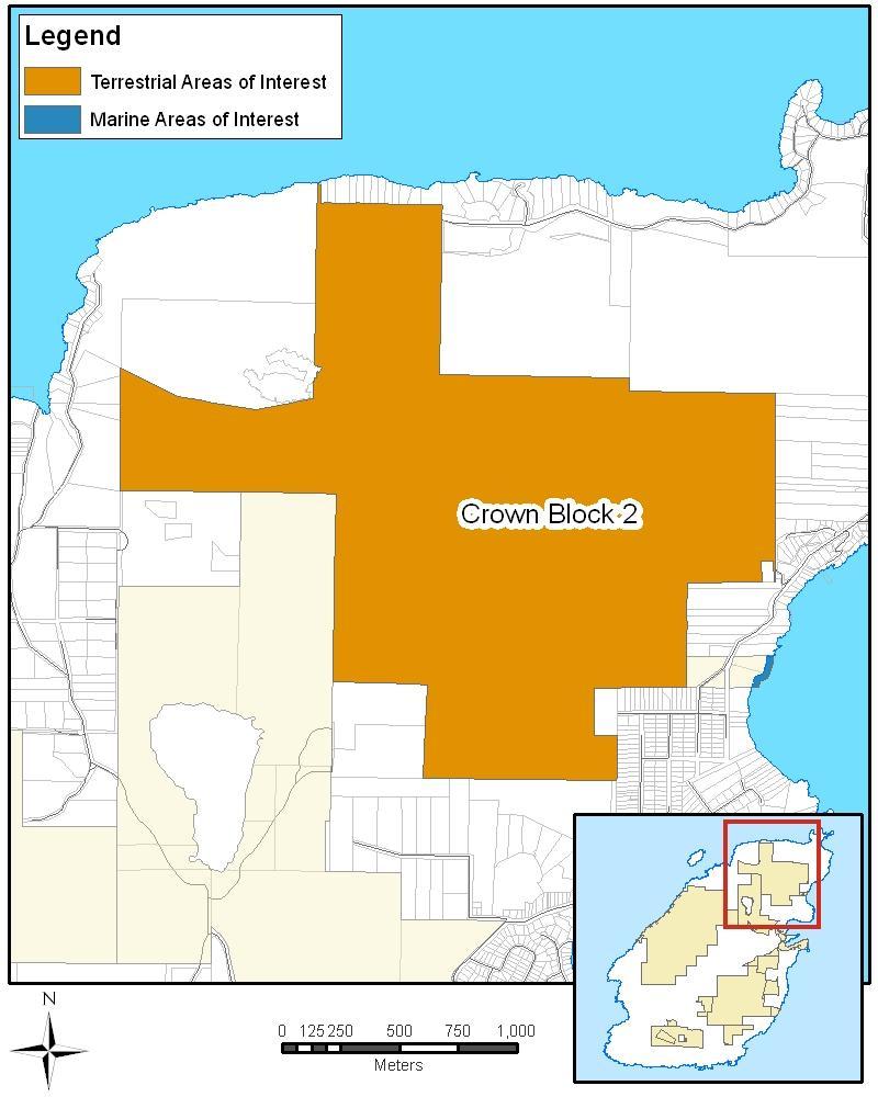
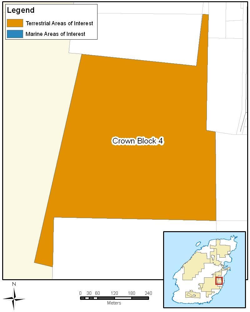
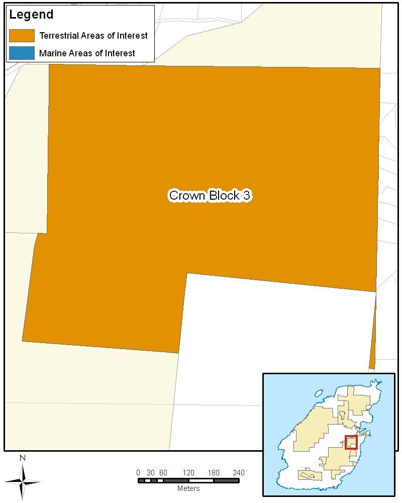
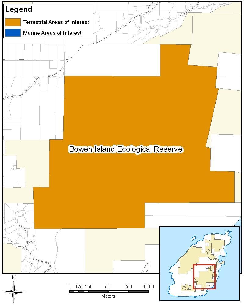
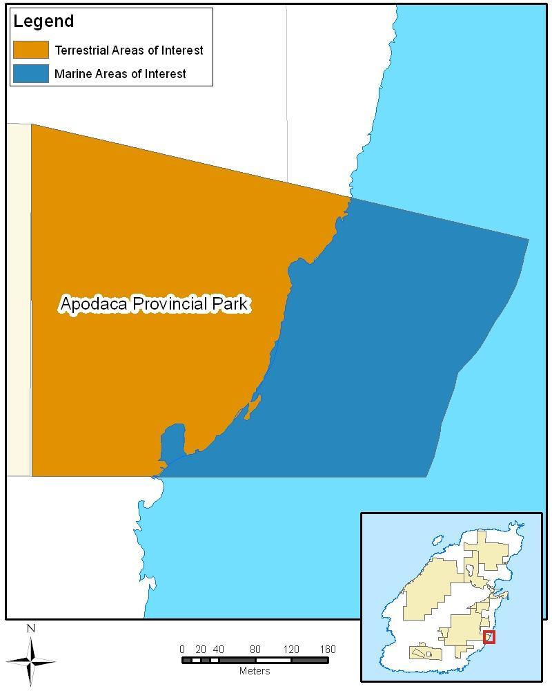
29 Table 5. Parks Canada Terrestrial Areas of Interest PRELIMINARY REVISED PROPERTY NAME Included in Preliminary Concept Land Size (ha) Included in Proposed Concept Size (ha) COMMENTS Crown Block 1: Mount Gardner Yes Yes No change. Crown Block 2: Mount Collins Yes Yes No change. Crown Block 3: Valhalla Yes Yes No change. Crown Block 4: Queen Charlotte Heights Yes Yes No change. Crown Block 5: Cowan Point Yes Yes No change. Crown Block 6: Radar Hill Portion Larger portion Expanded. The Preliminary Park Concept did not include the eastern half of Block 6. Following consultation, the entirety of Block 6 has been added to the proposal, with the exception of the quarrying tenure and the right-of-way for the access road. Crown Land Block 7: Little Josephine Lake Yes Yes No change. Bluewater Shoreline Reserve - removed Yes 2.95 No N/A Removed. Portions of the reserve are now private land. The reserve is not connected to Mount Gardner, requiring public access from the water or over private land. Lieben No N/A Yes 3.74 Added. Bowen Island Ecological Reserve Yes Yes No change. Apodaca Provincial Park Yes 9.58 Yes 9.58 No change. Crippen Regional Park Yes Yes No change. Fairy Fen Nature Reserve Yes Yes No change. Singing Woods Nature Reserve Yes 9.37 Yes 9.37 No change. David Otter Nature Reserve - removed Yes 2.96 No N/A Removed. At the request of the donors. Quarry Park Yes 7.95 Yes 7.95 No change. Davies Creek Corridor Municipal Parks Yes Yes No change. Total Terrestrial Area of Interest 2, ,
30 Table 6. Parks Canada Marine Areas of Interest Feb. Boundary May Boundary PROPERTY NAME Crown Block 1: Mount Gardner Marine Component Apodaca Provincial Park Marine Component Included in Preliminary Concept Marine extension (m) Size (ha) Included in Proposed Concept Marine extension (m) Size (ha) Yes 200m Yes 200m Crippen Regional Park Marine Component Yes 200m 21.5 No COMMENTS Yes 200m 6.76 Yes 200m 6.76 No change. 200m and 25m 12.7 Expanded. Preliminary Concept excluded water directly in front of privately owned properties, but extended to 200m off-shore. The marine area of interest now extends into Hutt Channel to encompass marine features and the area of upwelling. Reduced. Marine area reduced to 25m inside Snug Cove. Marine area added (25m extension) inside head of Snug Cove and in Deep Bay. Lieben No N/A N/A Yes 25m 0.45 Added. 25m marine extension off Lieben property. Total Marine
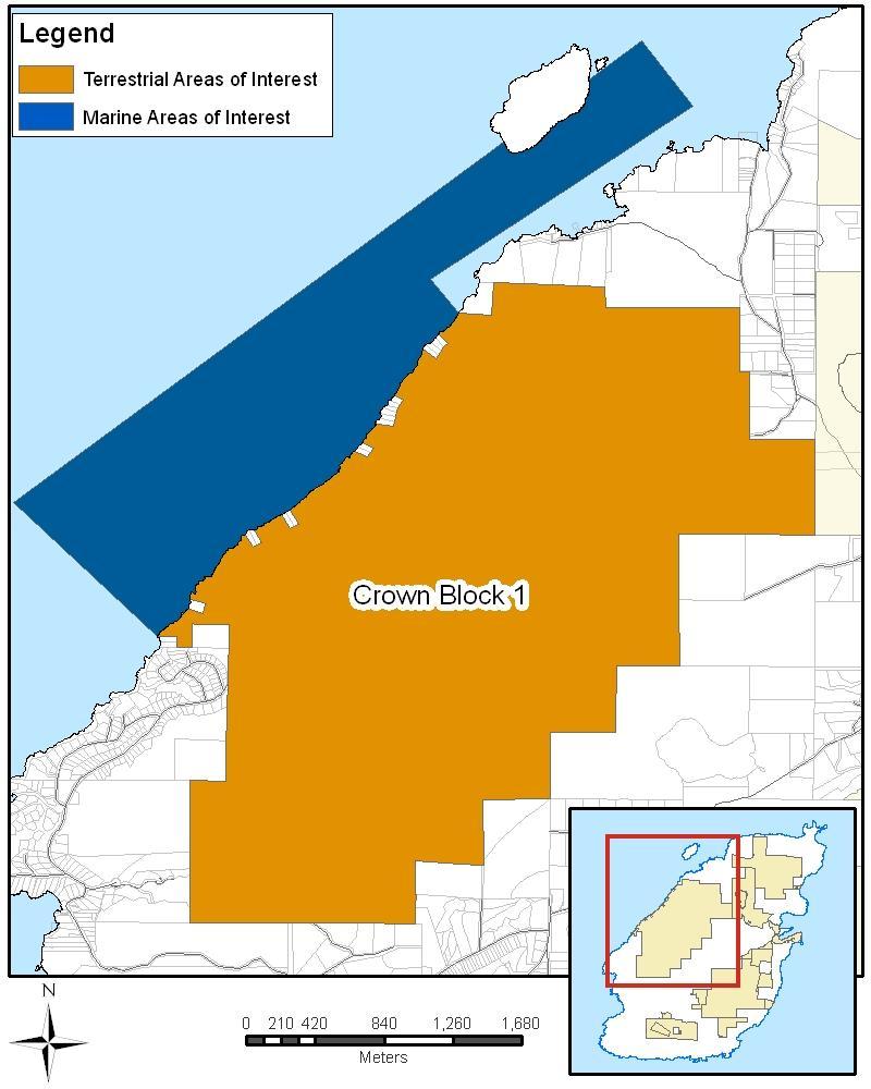
31 BC Crown Block 1: Mount Gardner For natural features, Mount Gardner has exceptionally high conservation value as a large and relatively undisturbed protected area with old growth forest, second growth forests, bogs, and the headwaters for 20 creeks. At 870 hectares, it is the largest piece of Crown land on the island as well as the highest in elevation. For visitor experiences, Mount Gardner s trail network, including a summit vista, could make it a valuable area for recreation. The trails are already used for a variety of activities including hiking, mountain biking, and horseback riding. Land Owner Land Type Size Visitor Experience Opportunities Ecological Values Parks Canada Rating Initial Tenure Analysis Considerations Recommendation Province of British Columbia Crown land 870 hectares terrestrial, more than 345 hectares marine - Network of trails; including viewpoints with 360-degree views. - Hiking, mountain biking and horseback riding opportunities. - Opportunity to explore facilitating water-based activities - Includes headwaters for eight community watersheds; four of these creeks have been delineated as provincial Sensitive Ecosystem Inventory (SEI) sites while the remaining are included within larger forested SEI sites. - The wetlands in this block and are within SEI sites of high conservation value, in particular Smooth Swamp and Saddle Bog. - One of the largest remaining areas of undisturbed old growth forest in the area. - The SEI of 2000 identified all of this block as sensitive ecosystems, primarily for its older forest and older second growth forest, among the most significant in the region. - Size and diversity of block creates diverse habitats, and it includes a range of ecosystems (mature forest, old growth, young forest, wetlands and cliffs). - Size and diversity of this block creates diverse habitats with undisturbed forest interior conditions that are important for many species of breeding migratory songbirds, including a variety of warblers, as well as many mammals such as bats and cougar and resident birds such as the Western Screech Owl and Blue Grouse. - One of the few known nesting sites in the province for Turkey Vulture. - The near shore marine environment is frequented by Western Grebe (red listed), Harlequin Duck (yellow listed), Mew Gull, Surf Scoter (blue listed), Marbled Murrelet (red listed), Common Murrelet (red listed), Great Blue Heron (blue-listed), Pigeon Guillemot and several species of gulls, ducks, cormorants, loons and mergansers. - Hutt Channel is the location of an upwelling area and is important habitat for rockfish, Giant Pacific octopus, as well as the location of glass sponges. Very high priority area. Contains greatest amount of very high and high ecological value rankings of any area of interest, and greatest amount of sensitive ecosystems. Initial assessment found 47 tenures. The majority can be accommodated under the Canada National Parks Act (e.g., water licence and water agreement, utility licence, right of way); 12 require further investigation and may need to be excluded (ex. mineral claims, quarrying reserve notation). - Both BC s Parks Plan 90 (1991) and Bowen Island s Green Zone Report (1992) assign this block a high priority for protection as a provincial park. - Some of these property owners use walking trails that split from the formal trail system to access their properties. These pre-existing uses would be respected if a national park reserve were to be established. - The subdivided lots on Crown leases facing Collingwood Channel are not included in the proposed boundary. - Many of the watercourses support water licences for local domestic use. - Includes three watershed reserves, which delineate critical water catchments for the island. - Downhill mountain biking occurs in this Crown block. - Rights-of-ways for communications sites and their associated access roads on the peak of Mount Gardner. Road is gated to restrict access. - An 18.8 ha Gravel Pit and Quarry Reserve notation is located at the base of the northeastern slope of Mount Gardner. Include in Revised Park Concept. Expand the marine component in the Revised Park Concept to include more of Hutt Channel. 25
32 26
33 Crown Block 2: Mount Collins For natural features, Mount Collins offers an outstanding example of a rare marsh in southern British Columbia. Meadowhawk Marsh is one of the few undisturbed marshes in the Islands Trust area, known for its high dragonfly diversity. The area also has healthy stands of second growth forest mixed in with rocky outcrops, which serve as important wildlife habitat and acts as a wildlife corridor to Killarney Lake. For visitor experiences, Mount Collins does not have a well-established trail network. Land Owner Land Type Size Visitor Experience Opportunities Ecological Values Cultural Values Parks Canada Rating Initial Tenure Analysis Considerations Recommendation Province of British Columbia Crown land 332 hectares - Less developed trails and more limited access than Mt. Gardner. - Fourth greatest amount of area containing very high and high ecological values, yet low ecological value per unit area (31%). - Characterized by healthy stands of second growth forest ( yrs old), interspersed with old growth Douglas fir trees, rocky knolls and outcrops. - Meadowhawk Marsh is one of the most undisturbed, biologically diverse and ecologically rare marshes in southern BC. - Contains a moderate amount (over 100 ha) of sensitive ecosystems. - Larger forest interior core provides important wildlife habitat. Presence of archaeological sites is subject to further research. High priority rating. Initial assessment found 21 tenures. The majority can be accommodated under the Canada National Parks Act (e.g., water licence and water agreement, utility right-of-way); 1 requires further investigation. - Several residential leases along the coastline adjacent to the channel north of Bowen Island are now excluded from Crown land. Access to these properties is by road or boat. - Licenses and infrastructure to utilize water in creeks in this block. - Other streams and water bodies support water licenses with recharge areas within this Block. - 3 designated watershed reserves. - A horse trail crosses the western portion of the block (full trail goes from Woods Road to Honeymoon Lake). Include in Revised Park Concept. 27
34 28
35 Crown Block 3: Valhalla and Crown Block 4: Queen Charlotte Heights For natural features, the Valhalla and Queen Charlotte heights properties provide an important buffer to Bowen Island Ecological Reserve and Singing Woods Nature Reserve. The lands also include roosting sites for bird species and a salmon-bearing stream. For visitor experiences, Valhalla and Queen Charlotte Heights properties do not offer significant recreational opportunities. Crown Block 3: Valhalla Land Owner Land Type Size Visitor Experience Opportunities Ecological Values Parks Canada Rating Initial Tenure Analysis Considerations Recommendation Province of British Columbia Crown land 47 hectares - Walking trails. - 78% of the area contains very high and high ecological values. - High proportion of sensitive ecosystems. - Habitat connectivity: adjacent to the ecological reserve and Singing Woods Nature Reserve. - Contains important breeding and roosting sites for a variety of bird species. - Of watercourses originating in or traversing this block, Davies Creek is salmon bearing. - Detailed wildlife data is not available; however, this block is known to be a breeding site for Cooper s Hawk (Accipiter cooperii) and important communal roost sites for the Common Raven (Corvus corax) and Northwestern Crow (Corvus caurinus). - The Anna s Hummingbird (Calypte anna) is known to overwinter on this side of the island. High priority. Initial assessment found 9 tenures. All can be accommodated under the Canada National Parks Act (e.g., water licence, water agreement, utility right-of-way). - Recharge area several creeks, including Davies Creek, Robertson Creek, Trimble Creek. - Watercourse licenses and infrastructure exist for human use and consumption. - Trail on the eastern side of this block. Include in Revised Park Concept. Crown Block 4: Queen Charlotte Heights Land Owner Land Type Size Visitor Experience Opportunities Ecological Values Parks Canada Rating Initial Tenure Analysis Consideration Recommendation Province of British Columbia Crown land 31 hectares - Recreation opportunities are limited by steep slopes - Low amount of ecological value per unit area. - Adjacent to ecological reserve. - Small amount of sensitive ecosystems (10 ha). - Detailed wildlife data is not available; this block is known to be a breeding site for Cooper s Hawk and important communal roost sites for the Common Raven and Northwestern Crow. - The Anna s Hummingbird (Calypte anna) is known to overwinter on this side of the island. Moderate priority. Initial assessment found 1 tenure for a watershed reserve; can be accommodated under the Canada National Parks Act. N/A. Include in Revised Park Concept. 29
36 30
37 Crown Block 5: Cowan Point For natural features, Crown Block 5 has exceptionally high conservation values with century-old Douglas fir forests dotted with small nutrient rich ponds and wetlands that enhance biodiversity and provide important wildlife habitat. There are several streams flowing through this block from Bowen Island Ecological Reserve, some of which supply drinking water for the community. For visitor experiences, Crown Block 5 contains a limited amount of multi-use trails. Land Owner Land Type Size Visitor Experience Opportunities Ecological Values Parks Canada Rating Initial Tenure Analysis Considerations Recommendation Province of British Columbia Crown land 52 hectares - Contains moderate recreation opportunities such as hiking and horseback riding. - Horse trail traverses the southern portion of the block. - 97% of the area contains high and very high ecological values. - Provides habitat connectivity as it is adjacent to the Ecological Reserve. - High proportion of sensitive ecosystems. - Block 5 and the Ecological Reserve are encompassed within SEI Site 1997, a very large older mixed second growth forest that provides the matrix and interconnectivity for a number of smaller ecosystem polygons. This site on its own is the ninth largest second growth forest identified in the entire SEI inventory area, and is the second largest older second growth ecosystem in the Islands Trust Area, surpassed in size only by Mt. Gardner. This SEI site is over 2.5 times larger than the next largest second growth ecosystem site in the Islands Trust Area (T1704 on D Arcy Island). - The conservation importance of this block cannot be overemphasized. Very high priority. - Initial assessment found 7 tenures: the majority can be accommodated under the Canada National Parks Act, including utility right-of-ways; 1 tenure for occupant licence to cut associated with the right-of-way. Several creeks support water licenses downstream. Include in Revised Park Concept. 31
38 32
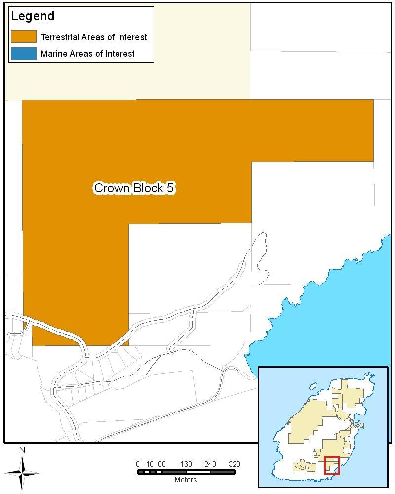
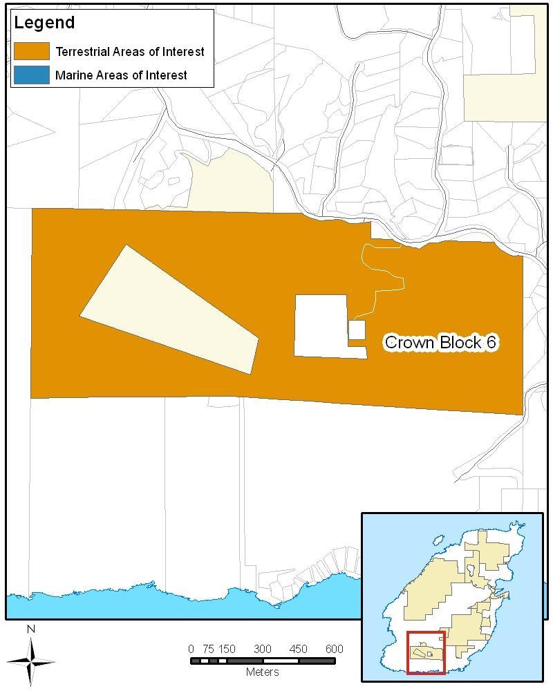
39 Crown Block 6: Radar Hill Radar Hill serves as a protective buffer to Fairy Fen. The forested area is one of the few areas on Bowen Island that includes both deciduous and coniferous trees. For visitor experiences, Radar Hill is an important connector between trail networks at Cape Roger Curtis, Mount Gardner and Crippen Regional Park, as noted in the community s Greenways Strategy. Land Owner Land Type Size Visitor Experience Opportunities Ecological Values Parks Canada Rating Initial Tenure Analysis Considerations Recommendation Province of British Columbia Crown land 79 hectares Preliminary Park Concept; 130 hectares Revised Park Concept - Contains moderate recreation opportunities (walking, hiking, horseback riding). - Located within SEI Site #1990A which is one of only two older Second Growth polygons in the entire SEI Study Area that contain both coniferous and mixed deciduous forest within their boundaries (The other site is near St. John s Point on Mayne Island). The relative rarity of this type of landscape is indicative of its high conservation values. - Contains the third greatest amount of very high and high ecological value ranking of any area of interest. - Encompasses and serves as a protective buffer to Fairy Fen. - Contains the third greatest amount of sensitive ecosystems of all areas of interest. - Composed of rare older second growth forests that contain both coniferous and mixed deciduous trees. Very high priority Initial assessment found 8 tenures. The majority can be accommodated under the Canada National Parks Act (e.g., water licence and water agreement); 1 requires further action. - Due to a crown licence for quarrying, a section of Block 6 was removed from the initial proposed boundary. - There are a number of gazetted rights of way throughout this Block most related to access to communication tower sites. - There are several VHF (very high frequency) towers located on leases near the highest point. Adjust boundary to include all of Block 6, with the exception of the quarrying licence and the right-of-way for the quarry access road. 33
40 34
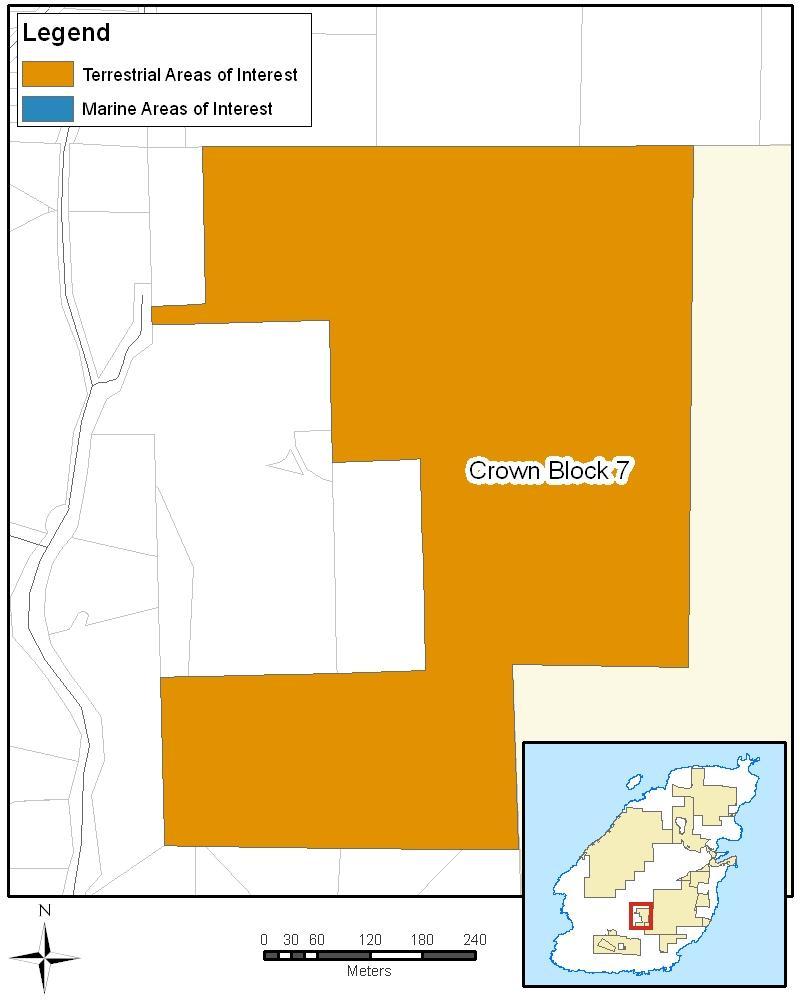
41 Crown Block 7 - Little Josephine Lake (Hen Cloud Forest) For natural values, Little Josephine Lake serves as an important buffer to the Bowen Island Ecological Reserve. The isolated forests provide the mix of nesting habitat, food and cover to support many bird species including the Great blue heron, sharp-shinned hawk, varied thrush and Hutton s vireo. Land Owner Land Type Size Visitor Experience Opportunities Ecological Values Parks Canada Rating Initial Tenure Analysis Considerations Recommendation Province of British Columbia Crown land 33 hectares - Unknown. - Because of the isolated location of this block, it provides habitat for several wildlife species not found elsewhere on the island. - Keystone species observed include Great Blue Heron (blue-listed), Turkey Vulture, Bald Eagle, Pileated Woodpecker, Cooper s Hawk, Sharp-shinned Hawk, Western Screech Owl and Barred Owl. All of these species require extensive areas of older forest for nesting habitat, food and cover. - Several of the more bird species nesting here include Band-tailed Pigeon, Blue Grouse, Varied Thrush and Hutton s Vireo. - 96% of the area contains very high and high ecological values. - High proportion of sensitive ecosystems. Very high priority Initial assessment found 7 tenures. All can be accommodated under the Canada National Parks Act (e.g., water licence and watershed reserve). - The parcel is a recharge area for two springs, one of which flows into Proudlock Brook and then on to Grafton Lake, the other flowing into a tributary of Josephine Creek. Both creeks have numerous downstream water licenses. - Three watershed reserves overlap on this Crown Block and provide important recharge functions for two of the major domestic water supplies on Bowen Island. - In 1999, a small public road was built (300 metres) in the northwest corner to provide access to adjacent land. Include in Revised Park Concept. 35
42 36
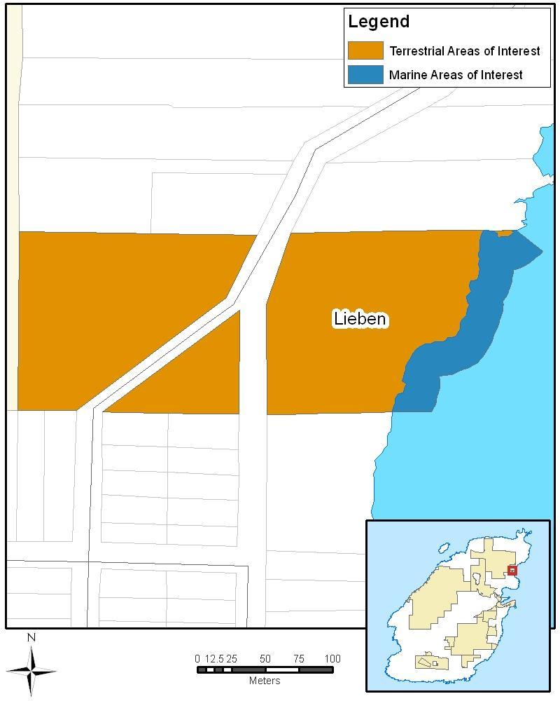
43 Vacant Crown Land: Lieben Lieben was not included in the Preliminary Park Concept; however, it is now included, following recommendations received during consultation, including submissions from the Bowen Island Heritage Preservation Association and Bowen Island Arts Council. For natural values, Lieben offers connectivity with Crown Block 2 Mount Collins and the ocean. For visitor experience values, Lieben offers a connection with the cultural community due to its history as a retreat for artists and writers, including several preeminent Canadians. Land Owner Land Type Size Visitor Experience Opportunities Ecological Values Cultural Values Parks Canada Rating Initial Tenure Analysis Considerations Recommendation Province of British Columbia Vacant Crown land 3.74 hectares terrestrial, 0.5 hectares marine - Opportunities to explore cultural history. - A walking trail exists on the property. - Land connectivity, adjacent to Block 2 Mount Collins baseline biological inventory - Steepness of the bluffs and creek ravine were a deterrent to logging, and stands of older forest remain intact. - High local historical value. - Former retreat for Canadian authors and artists. Not rated. N/A - The former owners of the 3.82-hectare property, Einar and Muriel Nielson gifted the land to the provincial government in April, 1977, with the request that it remain in perpetuity as a nature reserve with controlled public use and habitat management - Donated as part of the provincial Greenbelt Inventory program; now listed as vacant Crown land. - Structural remnants, including foundations and a collapsing out-building. - Public consultations indicated support for inclusion of Lieben. - Bowen Island Arts Council considers its role as a steward of the lands and would like to continue in that role, with the development of an interpretive site. - Partnership opportunity. Include in Revised Park Concept. Include marine area, 25m extension. 37
44 38
45 Bowen Island Ecological Reserve For natural values, Bowen Island Ecological Reserve has exceptionally high conservation values with extensive mature second growth forest and a wetland. The area supports a variety of plants such as skunk cabbage and wildlife such as the northwestern salamander. The lands have already been protected for close to forty years as an ecological reserve with no recreational opportunities. For visitor experiences, BC Parks has no services or facilities at Bowen Island Ecological Reserve, and visitor use is limited due to the ecological reserve status. The lands could offer opportunities for guidedinterpretation and research. Land Owner Land Type Size Visitor Experience Opportunities Ecological Values Parks Canada Rating Initial Tenure Analysis Considerations Recommendation Province of British Columbia Ecological Reserve (Crown land) 391 hectares - BC Parks provides no visitor facilities or services. - Due to its ecological reserve status visitor use is limited. - Potential visitor experience opportunities include those related to guided interpretation and or research. - Contains the second greatest amount of very high and high ecological value rankings, and second largest amount of sensitive ecosystems. - Contains relative extensive stand of mature second growth forest. - The two associations of greatest extent are the Douglas fir-salal-moss (Stokesiella oregano) and Douglas fir-tall Oregon grape-licorice fern types. - Also found are lodgepole pine, western hemlock and western red cedar, among which the cedar-sitka spruce-skunk cabbage-sedge type is noteworthy. - Other tree species found include grand fir, bigleaf maple, arbutus, flowering dogwood, bitter cherry and cascara. - Amphibians recorded here include the northwestern salamander and Pacific tree frog. - Black-tailed deer and Douglas squirrels are present, while deer mice, Townsend voles and shrews are likely to occur based on their known presence on Bowen Island. - Birds have not been inventoried. Very high priority. Initial assessment found 4 tenures; all are compatible with being in a national park. - Current status is as an Ecological Reserve. Include in Revised Park Concept. 39
46 40
47 Apodaca Provincial Park For natural values, Apodaca Provincial Park contains exceptionally high conservation values that support unique plant communities including blue camas, sea blush and blue-eyed Mary. The park consists of steep escarpments along the ocean, with rocky knolls dominating most of the landscape. It also includes a small stream, Optimist Creek, with a year-round flow of water. The stream originates from a small lake in Bowen Island Ecological Reserve and leads to a shoreline waterfall. The marine area contains several tide pools and well-developed surge channels. For visitor experiences, the lands are currently only accessed by water or trail. The area offers views across Howe Sound to Vancouver and the Strait of Georgia with a spectacular backdrop of mountains. Land Owner Province of British Columbia Land Type Class A Provincial Park Size 10 hectares terrestrial, 7 hectares marine Visitor Experience - The park is accessible only by water or trail, being about a 45-minute walk on a combination Opportunities of public road and trail from the Snug Cove ferry terminal. It is accompanied by a legal right-of-way leading to it through adjacent private lands. - The park is undeveloped and has no visitor facilities - BC Parks currently lists visitor activities as including: photography, picnicking, nature study and shore-based fishing - Offers spectacular views and waterfront access Ecological Values - 100% of the area contains very high and high ecological values - Plants on these sites include Sea Blush (Plectritis, congesta), Blue-eyed Mary (Collinsia, sp.) and Death Camas (Zygadenus venosus). - There is a small population of Blue Camas (Camassia quamash) and this is one of the few known sites where this plant grows in the Lower Mainland region. - Rock outcroppings have well established moss/lichen communities (Rhacomitrium, Cladina). - Grasses and other herbaceous plants are evident in swales where sub-surface moisture travels down slope. - Offshore waters support a variety of marine birds, including the Marbled Murrelet, Pigeon Guillemot and Pelagic Cormorant. Marine mammals include harbour seal and killer whale. - Intertidal and undersea life includes anemones, Pacific octopus, rockfish and greenling. - Tidepools contain populations of ochre sea stars and tidepool sculpin. - Evidence in the form of pellet groups and browse sign indicates that blacktail deer use the park extensively, feeding on the spring growth of salal. - Typical forest birds in the park include the blue grouse, black-throated gray warbler, chestnut-backed chickadee and red-breasted nuthatch. Cultural Values - Major J.S. Matthews, a noted Vancouver historian, donated the property to the province as a memorial to his son. Established in The name of the park honours the name given to the islands at the entrance to Howe Sound by early Spanish navigators. Parks Canada Rating Very high priority Initial Tenure Analysis Initial assessment found two tenures; both can be accommodated under the Canada National Parks Act. Considerations park management plan indicates to general objectives: 1) preservation to preserve the special park features, including the unique plant communities; and 2) recreation to provide day use opportunities and walk-in overnight use. - There is water licence to draw water for domestic water purposes. Recommendation Include in Revised Park Concept, marine extension of 200m. 41
48 42
49 Crippen Regional Park For natural values, Crippen Regional Park is made up of diverse and, in many cases, sensitive ecosystems including mature forests, lakes, cliffs, wetlands, rural land and young forests. For visitor experiences, Crippen Regional Park and Killarney Lake are a focal point of public recreation on Bowen Island. Visitors can reach the lands immediately after stepping off the ferry. The area offers more than 12 kilometres of trails dedicated to walking, horseback riding and cycling. It has a rich history for visitors to discover through heritage orchards and cottages. Its facilities currently include a softball field, fish hatchery and picnic shelters. The lands present an exceptional opportunity to offer interpretation, school programs and overnight experiences in restored heritage cottages. Land Owner Land Type Size Visitor Experience Opportunities Ecological Values Cultural Values Parks Canada Rating Initial Tenure Analysis Considerations Recommendation Metro Vancouver Regional Park 242 hectares terrestrial, 13 hectares marine - Adjacent to the village of Snug Cove, walking distance from the ferry. - Extensive multi-use recreational opportunities exist including picnicking, walking, hiking, freshwater fishing, canoeing/kayaking, beach activities and nature appreciation. - An extensive network of well-marked walking (12.5km), horseback riding (5 km), and cycling (5km) trails. - Central feature is the 1.6 km trail to Killarney Lake which links up with a 4km trail circling the lake, complete with a boardwalk through wetlands. - Existing facilities include: softball field, fish hatchery and picnic shelters. - Provides access to other cultural/historical sites, such as Davies Orchards, and the causeway across the lagoon at the mouth of Killarney Creek. - Wheelchair accessible sites include: the causeway, Lady Alexandra Promenade and the Snug Cove picnic shelters. - Considerable opportunities to offer interpretation and school programs. - Fifth greatest amount of area containing very high and high ecological values. - Composed of diverse ecosystems ranging from mature forest, to lakes, cliffs, wetland, rural land and young forest. - Approximately half the land is composed of sensitive ecosystems. - Land connectivity, adjacent to Block 2 Mount Collins. - Occupies about 60% of the lands that used to be part of the Union Steamship Company s (USC) resort, including the heritage orchard and some of the original cottages. - High local historical value. Very high priority. 19 tenures. The majority can be accommodated under the Canada National Parks Act (e.g., water licence and water agreement); some require further investigation. - Crippen is controversial for inclusion in national park reserve lands. The telephone opinion survey indicates: 34% opposed; 32% supportive; 30% undecided; and 3% of respondents answered with it depends. - Of the approximately 181 hectares of land on Bowen Island within the Agricultural Land Reserve (4% of the island), about 99 hectares are on private lands, while the remaining 82 hectares are in Crippen Regional Park. - The park contains numerous historic buildings, such as the former USC cottages in Davies Orchard, some of which are in disrepair and may require significant investment for restoration. - A water lot lease is associated with Crippen. - Several associations and non-profits currently use these lands, licences of occupation, partnering agreements, etc. will need to be negotiated. - Community or collective gardens are activities which can occur in national parks. - One of the key reasons Parks Canada agreed to embark on the feasibility assessment is the opportunities that Crippen provides to reach an urban audience. - Crippen is the one location on the island where visitation is occurring in any significant numbers. Include in Revised Park Concept. Include marine component: 25m inside Snug Cove, 25m fronting property in Deep Bay, 200m elsewhere. 43
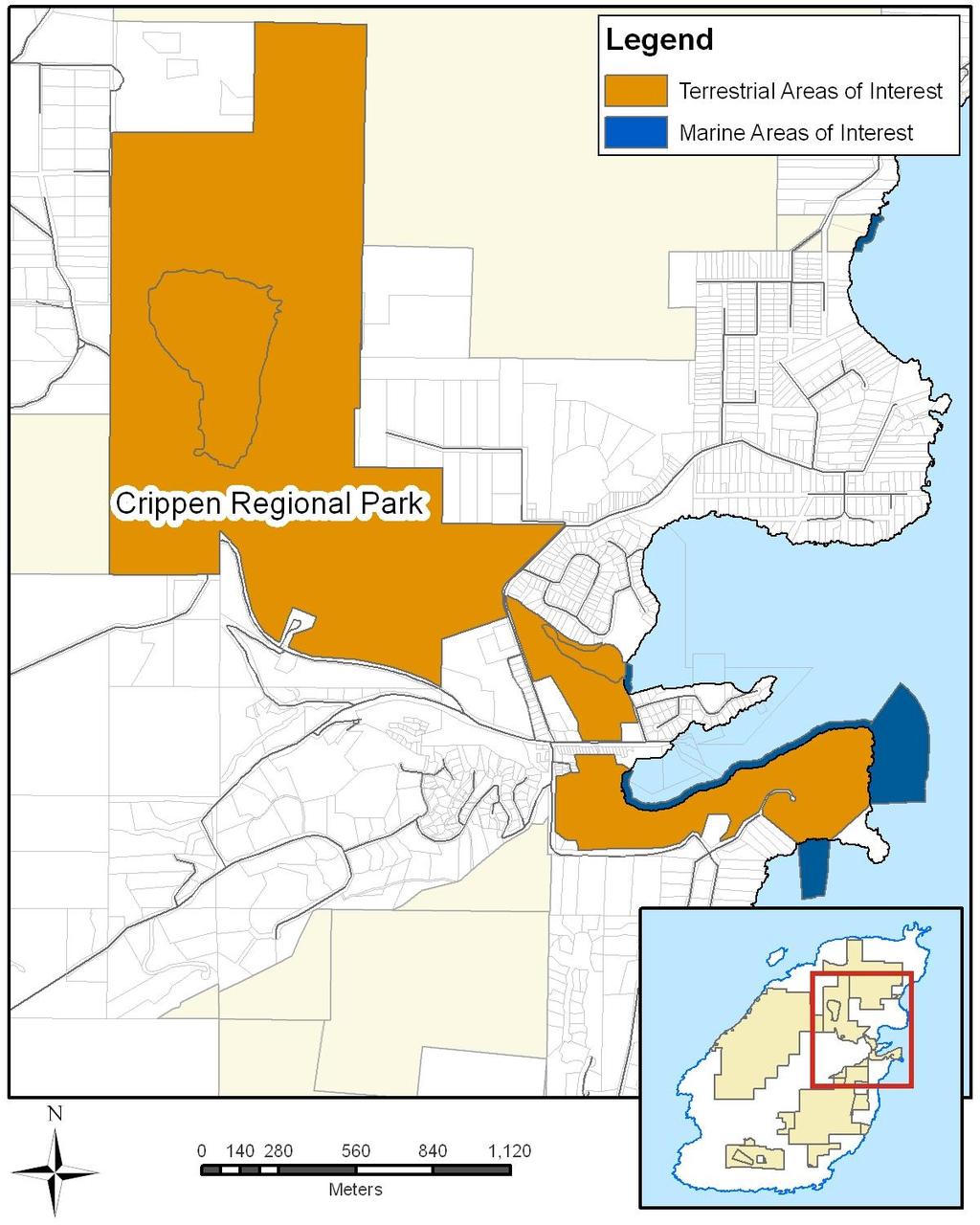
50 44
51 Islands Trust Fund: Fairy Fen Nature Reserve For natural values, Fairy Fen Nature Reserve contains exceptionally high natural values. It has one of the most ecologically rare fens in southern British Columbia, which supports plants such as Labrador tea, bog St. John s-wort and bog cranberry. It is surrounded by a forested area including western red cedar, red alder, big-leaf maple and lodgepole pine. For visitor experiences, Fairy Fen Nature Reserve may be too sensitive to support visitation, but the natural features could contribute to off-site interpretation. Land Owner Islands Trust Fund Land Type Islands Trust Fund Nature Reserve Size 18 hectares Visitor Experience - As Fairy Fen is a sensitive ecosystem, any future visitor experience offer will need to be Opportunities carefully considered, and opportunities for off-site interpretation should be considered. Ecological Values - 100% of the area contains very high and high ecological values. - Contains one of the most undisturbed, biologically diverse and ecologically rare fens in southern BC, in addition to some mature and young forests. - The fen supports plants such as Labrador tea, bog St. John s-wort, bog cranberry and a wide variety of sedges and mosses. - Entirely composed of sensitive ecosystems. Parks Canada Rating Very high priority. Initial Tenure Analysis N/A. Considerations - Special Preservation (Zone 1) should be considered for ecologically sensitive areas. - A management plan is currently under development by Islands Trust Fund, expected completion is summer Recommendation Include in Revised Park Concept. 45
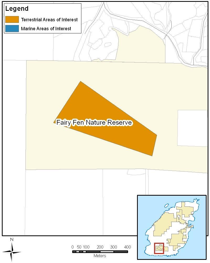
52 46
53 Islands Trust Fund: Singing Woods Nature Reserve For natural values, the Singing Woods Reserve provides important fish habitat and supports species such as cutthroat trout. It contains the headwaters for two creeks, Davies and Dorothy creeks, and provides nutrients to downstream fish populations. The area also acts as a wildlife corridor to Bowen Island Ecological Reserve, Crippen Regional Park and Josephine Lake. For visitor experiences, Singing Woods Nature Reserve currently supports walking and nature appreciation. Land Owner Land Type Size Visitor Experience Opportunities Ecological Values Cultural Values Parks Canada Rating Initial Tenure Analysis Considerations Recommendation Islands Trust Fund Islands Trust Fund Nature Reserve 9 hectares - Current supported uses included walking and nature appreciation. - 91% of the area contains very high and high ecological values. - Acts as an important ecological corridor to the Ecological Reserve and Block 3 Valhalla. - Environmentally sensitive, it lies in the headwaters for two creeks: Davies and Dorothy. - High fish values, with cutthroat trout observed; watercourses provide nutrients to downstream fish populations. - Vegetation community on the site is dominated by second growth Douglas fir, western red cedar, western hemlock, bigleaf maple, and red alder. Occasional old-growth veteran Douglas fir trees are also present. - Major under-storey species include sword fern, salal, dull Oregon grape, red huckleberry, and step moss. - High proportion of sensitive ecosystems. - Entire parcel of land is categorized as a red-listed ecosystem. Presence of archaeological sites is subject to further research. High priority There is a right-of-way (northern portion of the property) held by the municipality. - Management plan for the nature reserve created in 2000, including consultation with several interest groups. The plan notes the need for continued interaction with the groups for monitoring and management. Key actions in the plan include the need for old logging road reclamation and the removal of non-indigenous vegetation (holly). - Municipality designated right-of-way through the northern portion of the property. Include in Revised Park Concept. 47
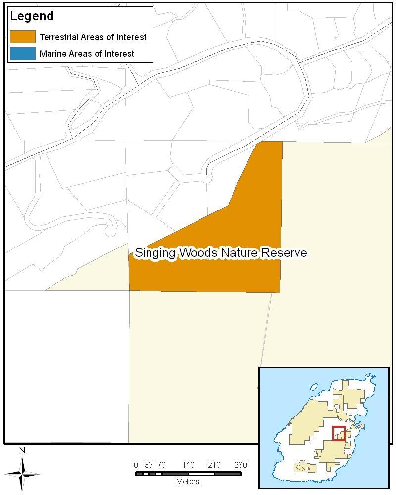
54 48
55 Bowen Island Municipal Park Lands: Quarry Park and Davies Creek Corridor Parks For natural values, the municipal lands provide ecological connectivity. Quarry Park For visitor experience values, Quarry Park provides walking, cycling and horseback riding opportunities on multi-use trails. Land Owner Land Type Size Visitor Experience Opportunities Ecological Values Parks Canada Rating Initial Tenure Analysis Considerations Recommendation Bowen Island Municipality Municipal Park 8 hectares - Established walking and multi-use trails. - The park provides ecological connectivity. Not rated separately; Crown Block 6 is rated as very high priority. N/A - Built infrastructure exists, including trails and bridges, and a stone art installation and moss garden. - Bowen Island Municipality recommended that Parks Canada continue to consider these lands for inclusion. Include in Revised Park Concept. Davies Creek Corridor Parks Land Owner Land Type Size Parks Canada Rating Initial Tenure Analysis Considerations Recommendation Bowen Island Municipality Municipal Parks 11 hectares Not rated independently; Crown Block 3 has a high priority rating. N/A - Bowen Island Municipality has recommended that Parks Canada continue to consider these lands for inclusion. - In the Preliminary Park Concept, these were called the municipal park lands adjacent to Crown Block 3. Include in Revised Park Concept. 49
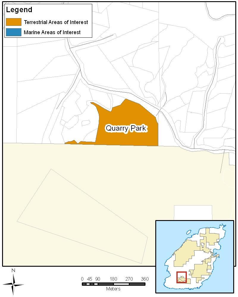
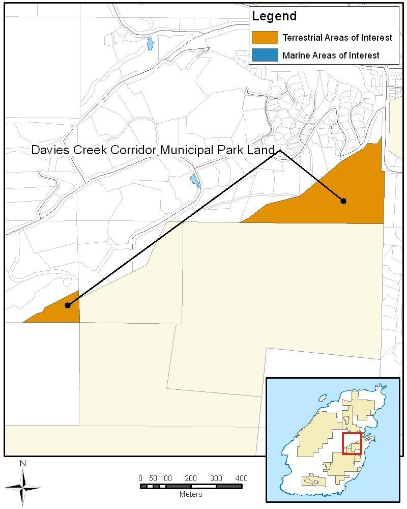
56 50
57 Bowen Island Municipal Park Lands: Seymour Landing Seymour Landing and the adjacent foreshore are areas under consideration; but not yet areas of interest. Land Owner Bowen Island Municipality Land Type Municipal Park Size 0.43 ha (terrestrial); 0.25m ha (25 marine); 0.67 (25m marine and extended off-shore) Parks Canada Rating Not rated. Initial Tenure Analysis There is a water works tenure. Considerations - Bowen Island Municipality has recommended that Parks Canada continue to consider this park and adjacent foreshore for inclusion. - An assessment is required to determine the condition of the marine and terrestrial environments, and ecological and cultural values. - A log dump was formerly located in this bay. - Seymour Bay is important to BIM, it is noted in the Official Community Plan (OCP) through the provision of parking to support moorage and a small dock. - The municipal park is not adjacent to any of the areas of interest. Recommendation If there is community support for the concept of national park reserve lands, conduct an assessment of the property and its foreshore. 51
 3 hectares - There are very limited opportunities for visitors.")

58 Crown Shoreline Reserve: Bluewater The Bluewater Crown Shoreline Reserve was included in the Preliminary Park Concept but is no longer being considered for national park reserve lands. Land Owner Land Type Size Considerations Recommendation Province of British Columbia Shoreline Reserve (Crown land) 3 hectares - There are very limited opportunities for visitors. - Sections of the Bluewater Shoreline Reserve are now private lands. These privately owned portions were not included in the Preliminary Park Concept. Bluewater Shoreline Reserve is divided by into three segments. - The reserve does not connect to Mount Gardner, and is only accessible via water or private property. Remove from consideration. Islands Trust Fund: David Otter Nature Reserve David Otter Nature Reserve was included in the Preliminary Park Concept but is no longer being considered at the request of the family who donated the land to Islands Trust Fund. Land Owner Land Type Size Ecological Values Cultural Values Parks Canada Rating Initial Tenure Analysis Considerations Recommendation Islands Trust Fund Islands Trust Fund Nature Reserve 3 hectares - Least amount of area containing very high and high ecological values. - Low ecological value per unit area (40%). - Primarily composed of mature western. hemlock and western red cedar forests. - Contains two blue-listed ecological communities. Presence of archaeological sites is subject to further research. Moderate priority. Conservation covenant held by Bowen Island Municipality. - No public access to the reserve exists; access is via private land. - The donors have indicated opposition for the inclusion of this piece of land in the national park proposal. Remove from consideration. 52
59 10. PARKS CANADA CONSIDERATIONS For national park reserve lands to be established on Bowen Island, there needs to be community and First Nations support, in addition to the proposal being congruent to Parks Canada s mandate and making sense operationally. This section examines several key areas of the proposal and recommendations received, while outlining Parks Canada s position. Areas of Interest The areas identified are areas of interest to Parks Canada. They are not the final boundaries for the park proposal. Adjustments can be made, and will likely be made, if the proposal proceeds to negotiations. These adjustments would be made to accommodate tenures, community development needs and the interests of the negotiating parties. If there is community support for the proposal, a detailed property analysis will be conducted, and this may reveal new tenure implications that require certain lands to be removed if they are not compatible with the Canada National Parks Act. In addition to the areas of interest outlined in this document and the Revised Park Concept, there are three topics that deserve further examination: private property acquisition, Crippen Regional Park and marine areas of interest. Private Property Acquisition Throughout the feasibility assessment, many people and organizations, including BIM, indicated that Parks Canada should consider purchasing some strategic private lands on a willing-seller, willing-buyer basis. It is important to note that there is no funding to pursue private land acquisition at this time. Should negotiations support private land acquisition on a willing-seller, willing-buyer basis, the lands would need to bring significant ecological and/or visitor experience values to the proposed park national park reserve lands. Crippen Regional Park Despite the diverse opinions, Crippen continues to be an essential part of the park concept, in part, because it has so many natural and recreational values, partnership opportunities, and it is remarkably accessible for visitors. For Parks Canada, national park reserve lands on Bowen Island would not be viable without Crippen. Marine Areas of Interest There was strong overall support for the marine areas to be included. BIM also indicated that we should consider the extent of the marine boundary within Snug Cove. During feasibility assessment consultations several marine areas were identified by experts and organizations (Appendix F). These recommendations are more extensive than what is included in the area of interest. Parks Canada has only included marine areas which are adjacent to lands under consideration in the park concept. Marine areas which are part of a national park reserve will not restrict rights of access, or established access to private land. In the Revised Park Concept, the marine areas extend 200 metres off most of the lands under consideration. This distance enables Parks Canada to ensure protection of the intertidal area and manage use as necessary. If there are no expert identified habitat areas, then the marine extension is reduced to 25 metres. The exception is the waters of Crown Block 1 (Mount Gardner), where the marine area of interest extends beyond 200m into Hutt Channel, an area identified as important rockfish and octopus habitat, as well as the location of glass sponges. 53
60 Park Management One Park Not Two Bowen Island is in the same natural region represented by Gulf Islands National Park Reserve consequently it will have many of the same management concerns and opportunities. It will not be cost effective to operate two separate parks. By managing Gulf Islands and Bowen Island together as one national park reserve, there would be enhanced expertise and staff. If national park reserve lands were to be established, Bowen Island would have dedicated Parks Canada staff representing the various functions (e.g., visitor experience, resource conservation, assets/ maintenance and the warden service); however, the lands on Bowen would be part of Gulf Island National Park Reserve. Local Advisory Body Bowen Island would have its own advisory board to provide advice on issues relating to park lands on the island. This board would also contribute to overall management direction for Gulf Islands National Park Reserve. The exact structure and membership of an advisory board would be determined through negotiations. First Nations Considerations Community support and support of First Nations is essential if this proposal is to proceed to negotiations. Community consultations with the Squamish First Nation are planned. The Revised Park Concept may change as a result of these consultations. Treaty Claims There have been concerns expressed by some Bowen Island community members in regards to treaty claims and the implications this may have for lands on Bowen Island. All crown land is subject to treaty claims, and Bowen Island s lands and waters have been identified as areas of interest by in the treaty process by two First Nations groups since the early 1990s. Articles and letters to the editor in the Bowen Island Undercurrent have noted that Crippen Regional Park is currently owned under a fee simple title by the Greater Vancouver Regional District, it is not subject to First Nation lands claims. However, Crippen lands are part of the territory that Squamish Nation asserts rights over, which can include the right to resource harvesting and cultural practices. If a national park reserve were to be established, there would be an opportunity for Squamish First Nation to discuss Crippen lands through the treaty process. If there was an interest in a specific portion of Crippen, Parks Canada would enter into a discussion with Squamish First Nation to thoroughly consider other options to accommodate the request, such as compensation for the land, development of economic opportunities, or the transfer of other lands in lieu of Crippen. Since Crippen is considered a fundamental part of national park reserve lands on Bowen Island in order to engage an urban audience, it is an area we would want to maintain part of the park reserve. Our first priority would be to protect the ecological integrity of Crippen and ensure it is available for future generations of Canadians to enjoy. 54
61 11. RECOMMENDATIONS FOR THE REVISED PARK CONCEPT This section outlines recommendations in regards to the Revised Park Concept, based on the results of technical studies, consultations and research conducted after the initial concept was presented. Recommendations Clarify the establishment process and better illustrate the park concept: Demonstrate how ideas and considerations addressed through all stages of establishment process: feasibility assessment, negotiations, establishment, interim management planning and management planning. Provide examples of how other parks operate to illustrate statements in the Revised Park Concept. Refine the areas under consideration: Remove David Otter Nature Reserve and Bluewater Crown Shoreline Reserve. Add Lieben; include a 25m marine area of interest. Expand the land considered in Block 6 Radar Hill. Reduce the marine area of interest inside the mouth of Snug Cove from 200m to 25m, but extend the 25m area further into the cove; and Add 25m of marine area in front of Crippen in Deep Bay. Expand the marine area of interest off the Mount Gardner Block. Clarify the must haves for Parks Canada: The inclusion of Crippen is essential to allow for the provision of a range of easily accessible visitor experience opportunities. National park reserve lands would be administered as part of Gulf Islands National Park Reserve. A local advisory board for Bowen Island would be established to ensure local consideration of issues on national park reserve lands on Bowen Island. 55
62 12. NEXT STEPS Canada and British Columbia recognize the importance of support from the Municipality of Bowen Island and First Nations for a national park reserve on Bowen Island. Canada and British Columbia have pledged to collaborate with all governments on the feasibility of the park proposal prior to any decision to move forward. If there is support for the concept of a national park reserve, and if the governments of British Columbia and Canada decide to move ahead to the next step, it would simply mean the proposal is ready to move forward to negotiations. If there is support for the concept of a national park reserve, your feedback, along with that of stakeholders, partners and First Nations will contribute to the feasibility assessment report submitted to governments for their consideration. If there is no support for the concept of a national park reserve, the Revised Park Concept will not be revised and the feasibility assessment will be concluded. Your Input is Invited This report is a preliminary report, as it summarises the assessment results to date. We welcome your review and comments. Please submit any comments by October 15, Comments received on this Preliminary Assessment Report will help us better understand any outstanding issues and potential mitigations. 56
63 REFERENCES This report draws on and contains excerpts from previous assessments and reports in regards to the feasibility assessment for national park lands on Bowen Island. Resources include: Bowen Island Advisory Planning Commission. March 23, A National Park Reserve for Bowen Island: Review and Recommendations. Report to Bowen Island Municipal Council. Brent Mahood. March 25, National Park Reserve Concept Plan: Staff Comments. Report to Bowen Island Municipal Council. Dunster & Associates Environmental Consultants Ltd. November The Crown Lands of Bowen Island: An Inventory and Assessment of Resources and Values. Greater Vancouver Regional District. July 1988.Concept Plan for Crippen Regional Park draft. Green Zone Technical Sub-Committee Bowen Island Green Zone Report. Greenways Advisory Committee. March 24, Comments Preliminary Park Concept Parks Canada and Proposed Guiding Principles. Report to Bowen Island Municipal Council. Islands Trust Fund. May Management Plan for David Otter Nature Reserve. Prepared by: Taara Environmental. Islands Trust Fund. October Management Plan for Singing Woods Nature Reserve. Prepared by: Pottinger Gaherty Environmental Consultants. Lions Gate Consulting. July, Social Impact Assessment of the Potential for National Park Reserve Lands on Bowen Island. Lions Gate Consulting. January 28, Economic Impact Assessment of the Potential for National Park Reserve Lands on Bowen Island. McAllister Opinion Research Bowen Island Poll: Local Perspective on the Proposed National Park Reserve. Metro Vancouver Park Staff. September Crippen Regional Park. Information compiled by West Area Office. National Park Community Advisory Committee. April 4, Bowen Island National Park Reserve Community Consultation Report. National Park Council Committee. April 1, Report to BIM Council. National Park Council Committee/Inter-Island Mission participants. September 22, Report on Inter-Island Mission To Gulf Islands National Park Reserve, September 8 and 9, Including Questions, Opportunities and Concerns. Parks Canada. November 27, Concepts Workshop: Summary Report: A Feasibility Assessment of the Potential for National Park Reserve Lands on Bowen Island. Available by request, English only. Parks Canada. November 3, Visioning Workshop: Summary Report: A Feasibility Assessment of the Potential for National Park Reserve Lands on Bowen Island. Available by request, English only. Parks Canada. September What We Heard: Phase 1 Public Consultations: A Feasibility Assessment of the Potential for National Park Reserve Lands on Bowen Island. Available by request, English only. Parks Canada. February An Assessment of Select Properties on Bowen Island For their Potential 57
64 Inclusion in Gulf Islands National Park Reserve. Author: W.D. Henwood. Coastal British Columbia Field Unit. Sidney, BC. Unpublished. Parks Canada Core Area Assessment for Land Acquisition/Land Stewardship. Gulf Islands National Park Reserve, Parks Canada, Sidney, B.C. Unpublished. South Coast Region Parks and Outdoor Recreation Division. November Apodaca Provincial Park Master Plan. Ministry of Lands, Parks and Housing, Province of British Columbia. Approved
65 APPENDICES A. Summary of Public Consultations and Outreach Activities Organized and/or Attended by Parks Canada staff Date Event Location Attendance August 26, 2010 Bowen Island Info Session Bowen Island 200 August 28, 2010 Bowfest Community Festival Booth Bowen Island 100 August 30, 2010 North Vancouver Info Session North Vancouver 35 August 31, 2010 West Vancouver Info Session West Vancouver 45 September 8-9, 2010 Gulf Islands Inter-Island Mission Gulf Islands 13 October 2, 2010 Gulf Islands Inter-Island Mission Info Session Bowen Island 175 October 16, 2010 Open Space Session - Feasibility Assessment Bowen Island 60 November 3, 2010 Visioning Workshop Bowen Island 32 November 27, 2010 Concepts Workshop Bowen Island 25 November 27, 2010 Concepts and Vision Open House Bowen Island 125 December 9, 2010 Island Pacific School Visit Bowen Island 45 December 9, 2010 Island Discovery Learning Centre Visit Bowen Island 30 January 22, 2011 Open Space Session - Crippen Regional Park Bowen Island 125 February 5, 2011 Economic Impact Assessment Information Session Bowen Island 160 February 16, 2011 Bowen Island Mother's Group Bowen Island 7 February 16, 2011 Meet and Greet at Local Pub Bowen Island 40 February 26, 2011 Preliminary Park Concept Info Session Bowen Island 190 March 2, 2011 Preliminary Park Concept Info Session West Vancouver 30 March 8-9, 2011 Bowen Island Community School Visits Bowen Island 315 TOTAL 1,752 59
66 B. Overview of Communication Products Product Type Date Bowen Island Info Sheet Info sheet August 2010 Aboriginal Consultation Info sheet August 2010 Questions and Answers Info sheet January 2011 Project Update Info sheet January 2011 Understanding the Process Info sheet February 2011 Feasibility Assessment introductory presentation PowerPoint presentation September 2010 What We Heard - Phase 1 Consultations Report September 2010 Bowen Island Website Website August ongoing Synopsis of Phase 1 Consultations Report September 2010 Visioning Workshop Summary Report November 2010 Concepts Workshop Summary Report November 2010 Vision and Concepts Open House Summary Report November 2010 What We Heard: Open Space on Crippen Regional Park Report January 2011 Economic Impact Assessment Report February 2011 Economic Impact Assessment - Executive Summary Report February 2011 Preliminary Park Concept Report February 2011 Collaboration Ideas Welcome for Crippen Park Undercurrent submission February 2011 Understanding the Role of First Nations in the Feasibility Assessment Undercurrent submission February 2011 Why the Rush: Parks Canada Responds to Islanders' Question Undercurrent submission February 2011 Parks Canada Presents Concept for National Park Undercurrent submission February 2011 Parks Canada Offers a Variety of Job Opportunities Undercurrent submission March 2011 Preliminary Park Concept Ready for Public Input Undercurrent submission March 2011 Unique Natural Features Make Bowen Worth Protecting Undercurrent submission April
67 C. List of Workshop Attendees The following is a list of invitees and participants for the vision and concepts workshops. The list of invitees from Bowen Island was developed and approved by the Bowen Island Municipal Council. A list of 8 off-island invitees was developed by Parks Canada to represent interest groups. The first table outlines invitees who attended one or both of the workshops. The second table outlines invitees who did not attend. The Concepts workshop had one additional invitee, who was a representative from the Bowen Island Off Road Cyclists Association. Invited and Attended Organization Individual / marine interest Eco-alliance Bowen Island Improvement Association Canadian Parks and Wilderness Society (CPAWS) Nature Club Community Foundation Individual Vancouver Aquarium Bowen Island Conservancy Bowen Island Arts Council Bowen Island Horse Owners & Riders Association Bowen Island Heritage Preservation Association Outdoor Recreation Council of BC Chamber of Commerce Individual Individual / Schools Bowen Island Golf Association Individual Greenways Committee Community Housing Association True Green Participant Adam Taylor Brenda McLuhan Bruce Howlett Chloe O'Loughlin Claudia Schaefer Colleen O'Neill Dr. Hugh Freeman Eric Solomon (Vision) Everhard van Lidth de Jeude Jaqueline Massey Katherin Beaulieu / Dawn Riley (Concepts) Marion Moore (Vision) / Karen Wristen (Concepts) Ray Pillman Paul Rickett Peter Arbuckle Sarah Haxby (Concepts) Spencer Grundy Stephen Foster Sue Ellen Fast Tim Rhodes Tim Wake (Vision) / Barbara Wahler (Concepts) Invited, Did Not Attend Organization Individual Individual / developer Young Naturalists Club of BC Environmental Educators Provincial Specialist Association for BC SFU - Faculty of Education North Shore Hikers SUCCESS Bowen Island Off Road Cyclists Association Participant Betsy Hodgins John Reid Kristine Webber Mr. Robinson Mr. Zandevliet President Selow Lee Dan Cowan (invited to Concepts only) 61
68 D. Overview of Stakeholder Consultation Date Event Method Location August 25, 2010 Project introduction with Bowen property owners Meeting Vancouver August 25, 2010 Project introduction with Metro Vancouver Parks staff Meeting Burnaby August 26, 2010 Parks Canada/Bowen Island National Park Council Committee (NPCC) Meeting Bowen Island August 26, 2010 Introductory Public Meeting with Parks Canada BIM NPCC and the Bowen community Meeting Bowen Island August 28, 2010 Parks Canada attended Bowfest Booth Bowen Island September 10, 2010 Meeting with individual Bowen property owners Meeting Vancouver September 14, 2010 Meeting with individual Bowen property owners Meeting Vancouver September 22, 2010 Project Introduction with BC Ferries Phone n/a September 23, 2010 Parks Canada/NPCC Meeting Vancouver September 28, 2010 Field trip of Crippen with Metro Vancouver Parks staff Meeting Bowen Island October 8, 2010 Parks Canada/NPCC Meeting Vancouver October 28, 2010 Meeting with BC Ferries and Bowen Island Ferries Advisory Committee Meeting Bowen Island November 1, 2010 Call with MP John Weston's Executive Assistant Phone n/a November 15, 2010 Bowen Island Municipality Council Meeting - draft vision presentation Meeting Bowen Island November 17, 2010 Meeting with BC Lands to initiate land tenure analysis Meeting Surrey December 9, 2010 Marine Components Meeting Meeting Vancouver December 9, 2010 Presentation to elementary school students at Island Pacific School Meeting Bowen Island December 9, 2010 Presentation to students at Island Discovery Learning Centre Meeting Bowen Island December 13, 2010 Bowen Island Municipality Council - Concepts workshop/open house presentation Meeting Bowen Island January 12, 2011 Meeting with NPCC Meeting North Vancouver January 13, 2011 Meeting with Bowen Island National Park Community Advisory Committee Meeting Bowen Island January 18, 2011 Meeting with Metro Vancouver Parks staff Meeting Vancouver January 20, 2011 Bowen Island Municipality Council Meeting Meeting Bowen Island January 26, 2011 Howe Sound Forum Meeting Gibsons February 1, 2011 Meeting with Bowen Island National Park Community Advisory Committee Meeting Bowen Island February 2, 2011 Meeting with Metro Vancouver Parks Committee Meeting Burnaby February 28, 2011 Bowen Island Municipality Council Meeting - Preliminary Park Concept presentation Meeting Bowen Island March 15, 2011 Meeting with Metro Vancouver CAO Meeting Burnaby March 21, 2011 Meeting with RCMP - Bowen detachment Meeting Bowen Island March 21, 2011 Meeting with Bowen Island Fish and Wildlife Club Meeting Bowen Island April 6, 2011 Meeting with Islands Trust Fund staff Meeting Victoria 62
69 E. Parks Canada Response to BIM Land Recommendations Property Name Municipal Assets Old General Store & Boulevard Cottage Snug Cove Municipal Dock Mount Gardner Dock Municipal Lands Preliminary Concept: Included No No No Quarry Park Yes Yes Revised Concept: Included Not included. Acquisition of assets can be considered in negotiations. Rationale from Municipality Potential to relocate library to a new facility. Financial support for community facilities. Visitor welcome, orientation, information, education programs. Maintain heritage integrity. Co-share provision of visitor information services. Financial support for community facilities. Park Entry point. Visitor experience and marine education features. Visitor access/connectivity with the mainland. Financial support for community facilities. Park entry point. Visitor experience and marine access. Visitor access/connectivity with the Sunshine Coast Financial Support for community facilities. Ecological connectivity. Lieben Lands No Yes Cultural heritage. Visitor experience. Oceanfront. Radar Hill portion of Crown parcel 6 Davies Creek Corridor Parks Seymour Landing Park No Yes No Yes Yes Under consideration Connectivity. Watershed protection. Exclusion area for industrial and community uses requires further review. Trail connectivity from Crippen to Crown Lands. Wildlife corridor. Requires further neighbourhood consultation prior to consideration as part of national park reserve. Possible park entry point, with passenger dock. Visitor experience and marine access. Marine anchorage. Requires further neighbourhood consultation prior to consideration as part of the national park reserve. Parks Canada Response From Parks Canada s perspective, any acquisitions need to be based on identified national park needs. If the need exists, then a property, such as the library, or an entirely new facility, would be part of the negotiation process. Was included in Preliminary Park Concept, continues to be included in Revised Park Concept. Included in Revised Park Concept. Opportunity for partnering agreement with the Bowen Island Arts Council in regards to visitor experience and education opportunities. All of Block 6 Radar Hill is now included, with the exception of the lands covered by the quarry tenure and associated right-of-way. Included in Preliminary Park Concept, as the municipal park lands adjacent to Crown Block 3, they continue to be included in Revised Park Concept. Area under consideration. An assessment is required to ensure it meets Parks Canada s criteria for lands and waters to be brought under the Canada National Parks Act. This assessment will determine if this will be considered further. 63
70 Property Name Municipal Lands Bluewater Crown Strip North Collins Ridge Shoreline Crown Lots Mount Gardner Dock Crown Strip Marine Areas Marine Conservation Areas - Howe Sound Issues Snug Cove Marine Area Private Lands Preliminary Concept: Included Yes Minimal No N/A Portions at 200m No Revised Concept: Included No No No N/A Portions at 25m and 200m Could be considered in negotiation Rationale from Municipality Coastal/shoreline access. Extension of Mount Gardner marine area. Requires further neighbourhood consultation prior to consideration as part of a national park reserve. Connectivity to marine biodiversity hot-spot (new). Shoreline access. Requires further neighbourhood consultation prior to consideration as part of national park reserve. Coastal trail/shoreline access. Potential for expanded dock and facilities. Requires further neighbourhood consultation prior to consideration as part of national park reserve. Marine conservation. Consideration for inclusion within the national Marine Conservation Area. Any consideration of Snug Cove marine areas must be compatible with existing transportation shipping lane, sewage outfall and future community use. Subject to foregoing recommendations in Council report. Council supports expansion of park concept plan area by purchase (on a willing seller, willing buyer basis) of lands and marine areas that enhance the national park reserve vision. Priority should be given to coastal public access (trails and beaches), protection of environmentally sensitive lands, protection of watershed and water supply catchments, inter-island multi-use trail connectivity. Parks Canada Response Bluewater Crown Shoreline Reserve was included in the Preliminary Park Concept. However, it was not labelled; the map was corrected on April 11, Initial tenure assessment indicated portions of the Crown shoreline reserve are now private land. Shoreline reserve is also not connected to Mount Gardner, requiring public access from the water or over private land. Comments received through consultation also indicated that many Bluewater residents did not support the idea. As such it is not included in the Revised Park Concept. Initial tenure assessment indicates there is only one small shoreline piece which remains Crown land, this was included in the Preliminary Park Concept, and continues to be included in the Revised Park Concept. The Mount Gardner Dock Crown Strip is not included. There is limited value to Parks Canada, as it is not connected to any of the lands under consideration. Inclusion of this area would introduce new transportation issues and concerns for neighbourhood residents. The Mount Gardner Dock Crown Strip is not included in the Revised Park Concept. A National Marine Conservation Area (NMCA) is currently not being considered for Howe Sound. This feasibility assessment is only looking at a marine component associated with national park reserve lands. Reduced from 200m to 25m on the waters facing Snug Cove. 25m marine area extended into the cove, bordering Crippen Regional Park. Currently no funding available. Private land acquisition addressed in the Revised Park Concept, see Private Lands. Should negotiations support private land acquisition, on a willing-seller, willing-buyer basis, the lands would need to bring significant ecological and/or visitor experience values to the proposed national park reserve lands. 64


71 F. Marine Areas Submitted to Parks Canada for Consideration Original Map Submission 65
Proposed National Marine Conservation Area Reserve Southern Strait of Georgia PROJECT UPDATE Spring 2012
 Proposed National Marine Conservation Area Reserve Southern Strait of Georgia PROJECT UPDATE Spring 2012 National marine conservation areas (NMCAs) are established to protect, conserve and present examples
Establishing a National Urban Park in the Rouge Valley
 STAFF REPORT ACTION REQUIRED Establishing a National Urban Park in the Rouge Valley Date: March 29, 2012 To: From: Wards: Reference Number: Executive Committee Deputy City Manager, Cluster B All p:\2012\cluster
Preferred Recreation Recommendations Stemilt-Squilchuck Recreation Plan March 2018
 Preferred Recreation Recommendations Stemilt-Squilchuck Recreation Plan March 2018 Below are the recommended recreation ideas and strategies that package together the various recreation concepts compiled
Proposed National Marine Conservation Area Reserve Southern Strait of Georgia PROJECT UPDATE Spring 2012
 Proposed National Marine Conservation Area Reserve Southern Strait of Georgia PROJECT UPDATE Spring 2012 National marine conservation areas (NMCAs) are established to protect, conserve and present examples
Committee. Presentation Outline
 CW-33-15 11/9/2015 Community and Corporate Services Committee November 10, 2015 1 Presentation Outline Background Vision and Objectives Study Process and Timeline Public and Stakeholder Engagement Organization
Steps in the Management Planning Process
 Steps in the Management Planning Process Developing a management plan for Kalamalka Lake Park will follow a multi-stage process. The planning process for this park is currently in the Draft Management
A GUIDE TO MANITOBA PROTECTED AREAS & LANDS PROTECTION
 A GUIDE TO MANITOBA PROTECTED AREAS & LANDS PROTECTION Manitoba Wildands December 2008 Discussions about the establishment of protected lands need to be clear about the definition of protection. We will
REVISED AGENDA. Special Council Meeting. Monday, September 11, 2017 (REVISED TO INCLUDE ON-TABLE ITEMS)
") Mission Statement In carrying out its mandate, Bowen Island Municipality will work towards conducting operations in a way that: Improves the economic, environmental and social well-being for present and
Mission Statement In carrying out its mandate, Bowen Island Municipality will work towards conducting operations in a way that: Improves the economic, environmental and social well-being for present and
MANAGEMENT DIRECTION STATEMENT June, 1999
 Thompson River District MANAGEMENT DIRECTION STATEMENT June, 1999 for Roche Lake Provincial Park Ministry of Environment Lands and Parks BC Parks Division Table of Contents I. Introduction A. Setting
Section II. Planning & Public Process Planning for the Baker/Carver Regional Trail began in 2010 as a City of Minnetrista initiative.
 Section II Planning & Public Process Planning for the began in 2010 as a City of initiative. city staff began discussions with the Park District on the possibility of a north/south regional trail connection
Northern Rockies District Value of Tourism Research Project December 2007
 Northern Rockies District Value of Tourism Research Project December 2007 Project Partners: Northern Rockies Regional District, Tourism British Columbia, Northern Rockies Alaska Highway Tourism Association,
Longmont to Boulder Regional Trail Jay Road Connection DRAFT FINAL REPORT
 Longmont to Boulder Regional Trail Jay Road Connection DRAFT FINAL REPORT December 2018 Project Summary Boulder County, Colorado, in partnership with the City of Boulder, is evaluating options for multi-use
Policy PL Date Issued February 10, 2014
 Subject RENEWABLE ENERGY ON CROWN LAND Compiled by Renewable Energy Program, Biodiversity Branch Replaces Policy Directives Waterpower Site Release Crown Land Onshore Windpower Development - Crown Land
BACKCOUNTRY TRAIL FLOOD REHABILITATION PROGRAM
 BACKCOUNTRY TRAIL FLOOD REHABILITATION PROGRAM Backcountry Trail Flood Rehabilitation A June 2013 Flood Recovery Program Summary In June 2013, parts of Southern Alberta were devastated from significant
January 14, Orange County Transportation Authority Attn: M2 NCCP/HCP 550 South Main Street P.O. Box Orange, CA
 Equestrian Trails, Inc. Corral 357 P.O. Box 1026 Trabuco Canyon, CA 92678 http://saddlebackcanyonriders.com/ President: James Iacono... 714-612-1789 January 14, 2016 Orange County Transportation Authority
12, 14 and 16 York Street - Amendments to Section 16 Agreement and Road Closure Authorization
 REPORT FOR ACTION 12, 14 and 16 York Street - Amendments to Section 16 Agreement and Road Closure Authorization Date: April 27, 2018 To: Toronto and East York Community Council From: Senior Strategic Director,
PROUDLY BRINGING YOU CANADA AT ITS BEST. Management Planning Program NEWSLETTER #1 OCTOBER, 2000
 PROUDLY BRINGING YOU CANADA AT ITS BEST VUNTUT NATIONAL PARK Management Planning Program NEWSLETTER #1 OCTOBER, 2000 INTRODUCTION This newsletter launches the development of the first management plan for
STAFF REPORT ACTION REQUIRED
 STAFF REPORT ACTION REQUIRED PLANNING AND CONSULTATION PROCESS FOR SECOND EXITS CHESTER STATION UPDATE Date: September 28, 2015 To: From: TTC Board Chief Executive Officer Summary Staff reported to the
Pillar Park. Management Plan
 Pillar Park Management Plan January 2014 Pillar Park Management Plan Approved by: Jeff Leahy Regional Director Thompson Cariboo Region BC Parks January 9, 2014 Date Brian Bawtinheimer Executive Director
JOSLIN FIELD, MAGIC VALLEY REGIONAL AIRPORT DECEMBER 2012
 1. Introduction The Federal Aviation Administration (FAA) recommends that airport master plans be updated every 5 years or as necessary to keep them current. The Master Plan for Joslin Field, Magic Valley
A summary report on what the community told us
 DECEMBER 2015 A summary report on what the community told us During August and September 2015, UrbanGrowth NSW in partnership with Newcastle City Council ran the Revitalising Newcastle community engagement
Appendix A BC Provincial Parks System Goals
 Appendix A BC Provincial Parks System Goals The British Columbia Provincial Parks System has two mandates: To conserve significant and representative natural and cultural resources To provide a wide variety
Yard Creek Provincial Park. Management Plan
 Yard Creek Provincial Park Management Plan Draft January 2010 Yard Creek Provincial Park Management Plan Approved by: telàlsemkin/siyam/chief Scott Benton Bill Williams Squamish Executive Director ation
3.0 LEARNING FROM CHATHAM-KENT S CITIZENS
 3.0 LEARNING FROM CHATHAM-KENT S CITIZENS An important aspect in developing the Chatham-Kent Trails Master Plan was to obtain input from stakeholders and the general public. Throughout the course of the
Restore and implement protected status that is equivalent, or better than what was lost during the mid-1990 s
 THE ROSSLAND RANGE, OLD GLORY AREA. Executive summary. The Friends of the Rossland Range Society, on behalf of the local outdoor community, seeks to accomplish the following with respect to the Old Glory
Resort Municipality Initiative Annual Report 2015
 Resort Municipality Initiative Annual Report 2015 Submitted by: City of Rossland in association with Tourism Rossland Prepared by: Deanne Steven Acknowledgements The City of Rossland would like to thank
A Master Plan is one of the most important documents that can be prepared by an Airport.
 The Master Plan A Master Plan is one of the most important documents that can be prepared by an Airport. A Master Plan is a visionary and a strategic document detailing planning initiatives for the Airport
Parkland County Municipal Development Plan Amendment Acheson Industrial Area Structure Plan
 Parkland County Municipal Development Plan Amendment Acheson Industrial Area Structure Plan New Plan Acheson Industrial Area Structure Plan Amendment Parkland County Municipal Development Plan Board Reference
Roberts Bank Terminal 2 Project
 OCTOBER 2012 Roberts Bank Terminal 2 Project The Roberts Bank Terminal 2 Project is a proposed new multi-berth container terminal at Roberts Bank in Delta, B.C. that would provide 2.4 million TEUs (twenty-foot
As outlined in the Tatshenshini-Alsek Park Management Agreement, park management will:
 Management Strategy General Strategy The priority management focus for the park is to ensure that its internationally significant natural, cultural heritage and recreational values are protected and that
Nakina Moraine Provincial Park. Interim Management Statement. Ontario. Ministry of Natural Resources
 Nakina Moraine Provincial Park Interim Management Statement Ontario Ministry of Natural Resources 1999, Queen's Printer for Ontario Printed in Ontario, Canada Additional copies of this publication can
Thank you for this third opportunity to comment on the proposed revisions to the Coconino National Forest Management plan.
 March 19, 2014 Flagstaff Biking Organization PO Box 23851 Flagstaff, AZ 86002 Vern Keller Coconino National Forest Attn: Plan Revision 1824 South Thompson Street Flagstaff, Arizona 86001 coconino_national_forest_plan_revision_team@fs.fed.us
PSP 75 Lancefield Road. Northern Jacksons Creek Crossing Supplementary Information
 PSP 75 Lancefield Road Northern Jacksons Creek Crossing Supplementary Information September 2017 The northern crossing of Jacksons Creek proposed within the Lancefield Road PSP is a key part of the ultimate
1.0 BACKGROUND NEW VETERANS CHARTER EVALUATION OBJECTIVES STUDY APPROACH EVALUATION LIMITATIONS... 7
 New Veterans Charter Evaluation Plan TABLE CONTENTS Page 1.0 BACKGROUND... 1 2.0 NEW VETERANS CHARTER EVALUATION OBJECTIVES... 2 3.0 STUDY APPROACH... 3 4.0 EVALUATION LIMITATIONS... 7 5.0 FUTURE PROJECTS...
Public Submissions in response to the Bill closed on 2 July 2015 and Council lodged a copy of the submission provided as Attachment 1.
 54 PLANNING AND ECONOMIC COMMITTEE 8 JULY 2015 3 SUSTAINABLE PORTS DEVELOPMENT BILL Neil Quinn 1/58/14 #4771706 RECOMMENDATION: That Council endorses the Submission made to the Infrastructure, Planning
Chapter 1: Introduction Draft
 Chapter 1: Draft TABLE OF CONTENTS 1... 4 1.6.1 Stakeholder Engagement Plan... 10 Chapter 1 Page 2 TABLE OF EXHIBITS Exhibit 1.1-1 ABIA Annual Growth Since 1993... 5 Exhibit 1.4-1: ABIA Location Map...
Ministry of Parks, Culture and Sport. Plan for saskatchewan.ca
 Ministry of Parks, Culture and Sport Plan for 2018-19 saskatchewan.ca Table of Contents Statement from the Minister... 1 Response to Government Direction... 2 Operational Plan... 3 Highlights... 7 Financial
Chapter 1: Introduction
 Chapter 1: TABLE OF CONTENTS 1... 4 1.1 Master Plan Study Content... 4 1.2 Purpose and Scope of Master Plan Study... 4 1.3 Airport History and Role... 6 1.4 Airport Location and Service Area... 6 1.5 ABIA
Criddle/Vane Homestead Provincial Park. Management Plan
 Criddle/Vane Homestead Provincial Park Management Plan 2 Criddle/Vane Homestead Provincial Park Table of Contents 1. Introduction... 3 2. Park History.... 3 3. Park Attributes.... 4 3.1 Natural.... 4 3.2
ROAD AND TRAIL PROJECT APPROVAL
 ROAD AND TRAIL PROJECT APPROVAL www.marincountyparks.org Marin County Parks, 3501 Civic Center Dr, Suite 260, San Rafael, CA 94903 DATE: July 12, 2017 PRESERVE: Gary Giacomini Open Space Preserve PROJECT:
Chapter 9: National Parks and Protected Areas
 Part 9.1 Torngat Mountains National Park Reserve 9.1.1 The area set out in the Map Atlas (shown for illustrative purposes only in schedule 9-A) and described in appendix D-2 shall become a National Park
Clearwater Lake Provincial Park. Draft Management Plan
 Clearwater Lake Provincial Park Draft Management Plan Clearwater Lake Provincial Park Draft Management Plan Table of Contents 1. Introduction... 3 2. Park History... 4 3. Park Attributes... 4 3.1 Location/Access...4
APPENDIX. Alberta Land Stewardship Act AMENDMENTS TO THE SOUTH SASKATCHEWAN REGIONAL PLAN
 APPENDIX Alberta Land Stewardship Act AMENDMENTS TO THE SOUTH SASKATCHEWAN REGIONAL PLAN 1 All references to Alberta Environment and Sustainable Resource Development, Environment and Sustainable Resource
PRESS RELEASE CANADIAN ZINC SUPPORTS EXPANSION OF NAHANNI NATIONAL PARK
 PRESS RELEASE CZN-TSX CZICF-OTCBB FOR IMMEDIATE RELEASE CANADIAN ZINC SUPPORTS EXPANSION OF NAHANNI NATIONAL PARK PRAIRIE CREEK MINE EXCLUDED FROM ENLARGED PARK ACCESS RIGHTS TO BE PROVIDED BY NEW LEGISLATION
FILE: /PERM EFFECTIVE DATE: May 16, 2014 AMENDMENT:
 APPROVED AMENDMENTS: Effective Date Briefing Note /Approval Summary of Changes: FILE: 11000-00/PERM EFFECTIVE DATE: May 16, 2014 AMENDMENT: Table of Contents 1. POLICY APPLICATION... 1 2. PRINCIPLES AND
MONTEREY REGIONAL AIRPORT MASTER PLAN TOPICAL QUESTIONS FROM THE PLANNING ADVISORY COMMITTEE AND TOPICAL RESPONSES
 MONTEREY REGIONAL AIRPORT MASTER PLAN TOPICAL QUESTIONS FROM THE PLANNING ADVISORY COMMITTEE AND TOPICAL RESPONSES Recurring topics emerged in some of the comments and questions raised by members of the
Decision Memo Broken Wheel Ranch Equestrian Outfitter Special-Use Permit Proposed Action
 Decision Memo Broken Wheel Ranch Equestrian Outfitter Special-Use Permit USDA Forest Service Mississippi Bluffs Ranger District, Shawnee National Forest Jackson and Union Counties, Illinois Proposed Action
RESEARCH AND PLANNING FORT STEELE HERITAGE TOWN VISITOR STUDY 2007 RESULTS. May 2008
 RESEARCH AND PLANNING FORT STEELE HERITAGE TOWN VISITOR STUDY 2007 RESULTS May 2008 Research and Planning Tourism British Columbia 300-1803 Douglas St. Box 9830 Stn. Prov. Gov t. Victoria, BC V8W 9W5 Web:
Policy. Huts, Cabins and Lodges in BC Provincial Parks
 Policy Huts, Cabins and Lodges in BC Provincial Parks Federation of Mountain Clubs of BC Version 1.3 Published August 2, 2015 INTRODUCTION The Federation of Mountain Clubs of BC (FMCBC) promotes self-propelled
Engagement Summary Report. Trans-Canada Highway 1 RW Bruhn Bridge and Approaches Project Community Engagement February 1 18, 2018.
 Trans-Canada Highway 1 RW Bruhn Bridge and Approaches Project Community Engagement February 1 18, 2018 Engagement Summary Report April 2018 Prepared by Kirk & Co. Consulting Ltd. Trans-Canada Highway 1
SUMMER VILLAGE OF SILVER SANDS. Municipal Development Plan
 SUMMER VILLAGE OF SILVER SANDS Municipal Development Plan Bylaw 253-2014 Adopted August 22, 2014 Summer Village of Silver Sands Municipal Development Plan Bylaw No. 253-2014 Page 2 1 INTRODUCTION 1.1 SETTING
Proposal to Redevelop Lower Kananaskis River-Barrier Lake. Bow Valley Provincial Park. Frequently Asked Questions
 Proposal to Redevelop Lower Kananaskis River-Barrier Lake Bow Valley Provincial Park Frequently Asked Questions What is being proposed? What are the details of the proposal? Where is the project area located?
Continental Divide National Scenic Trail Legislative History and Planning Guidance
 Continental Divide National Scenic Trail Legislative History and Planning Guidance Legislation, Policy, and Direction Regarding National Scenic Trails The National Trails System Act, P.L. 90-543, was passed
KANANASKIS COUNTRY PROVINCIAL RECREATION AREAS MANAGEMENT PLAN DRAFT TERMS OF REFERENCE - November 20, 2007
 KANANASKIS COUNTRY PROVINCIAL RECREATION AREAS MANAGEMENT PLAN DRAFT TERMS OF REFERENCE - November 20, 2007 BACKGROUND There are 42 Provincial Recreation Areas (PRAs) within Kananaskis Country located
MEETING MINUTES Page 1 of 5
 Page 1 of 5 50178.000 May 26, 2009 PROJECT PROJECT NO. MEETING DATE ISSUE DATE Citizens Advisory Committee Meeting MEETING LOCATION MEETING PURPOSE Amy Eckland ISSUED BY SIGNATURE PARTICIPANT See attached
Engagement Summary Report. Trans-Canada Highway 1 RW Bruhn Bridge Replacement Project. Community Engagement November 15, 2016 to January 15, 2017
 Trans-Canada Highway 1 RW Bruhn Bridge Replacement Project Community Engagement November 15, 2016 to January 15, 2017 Engagement Summary Report February 2017 Prepared by Kirk & Co. Consulting Ltd. Trans-Canada
THAT the Board approve the final proposed concept plan for the Jericho Marginal Wharf site as shown in Figure C-4 of Appendix C.
 Date: January 17, 2012 TO: Board Members Vancouver Park Board FROM: General Manager Parks and Recreation SUBJECT: Jericho Marginal Wharf Phase 2 Concept Plan RECOMMENDATION THAT the Board approve the final
Blueways: Rivers, lakes, or streams with public access for recreation that includes fishing, nature observation, and opportunities for boating.
 Parks, Open Space and Trails PRINCE WILLIAM COUNTY 2008 COMPREHENSIVE PLAN TRAILS PLAN CONTENTS The components of the trails plan are: Intent Definitions Goals, Policies, and Action Strategies Trails Map
CITY CLERK. Toronto-Rochester Fast Ferry - Project Update (Ward 30 Toronto-Danforth)
") CITY CLERK Clause embodied in Report No. 5 of the, as adopted by the Council of the City of Toronto at its meeting held on May 30, 31 and June 1, 2001. 3 Toronto-Rochester Fast Ferry - Project Update (Ward
CITY CLERK Clause embodied in Report No. 5 of the, as adopted by the Council of the City of Toronto at its meeting held on May 30, 31 and June 1, 2001. 3 Toronto-Rochester Fast Ferry - Project Update (Ward
Outdoor Recreation Opportunities Management
 Outdoor Recreation Opportunities Management Introduction A major role of a management plan is to provide direction regarding the types of recreation that are appropriate, and to outline the steps that
Inclusion on the City of Toronto's Heritage Register Midtown in Focus Phase 1: Main Street Properties
 PG22.5 REPORT FOR ACTION Inclusion on the City of Toronto's Heritage Register Midtown in Focus Phase 1: Main Street Properties Date: August 10, 2017 To: Toronto Preservation Board Planning and Growth Management
Theme A ECOTOURISM DEVELOPMENT IN TANZANIA : THE SUSTAINABILITY CHALLENGE
 Theme A STATEMENT BY MR. PHILEMON L. LUHANJO, PERMANENT SECRETARY, MINISTRY OF NATURAL RESOURCES AND TOURISM-TANZANIA, AT THE SUMMIT OF CELEBRATION OF THE INTERNATIONAL YEAR OF ECOTOURISM, QUEBEC CANADA,
The Corporation of the City of Kawartha Lakes Council Report
 The Corporation of the City of Kawartha Lakes Council Report Report Number ENG2017-008 Date: September 12, 2017 Time: 2:00 p.m. Place: Council Chambers Ward Community Identifier: All Subject: Author Name
Rogue River Access and Management Plan Draft Alternatives
 Rogue River Access and Management Plan Draft Alternatives The Rogue River Access and Management Plan was initiated in December, 2011 and is being led by Jackson County Parks (JCP) and Oregon Department
PROPOSED PARK ALTERNATIVES
 8 Chimne y Rock State Park M a ster Pl an 2011 PROPOSED PARK ALTERNATIVES Introduction Three different park development concepts were prepared and presented to the citizens of North Carolina through a
Criddle/Vane Homestead Provincial Park. Draft Management Plan
 Criddle/Vane Homestead Provincial Park Draft Management Plan 2 Criddle/Vane Homestead Provincial Park Table of Contents 1. Introduction... 3 2. Park History.... 3 3. Park Attributes.... 3 3.1 Natural....
White Mountain National Forest Saco Ranger District
 United States Department of Agriculture Forest Service White Mountain National Forest Saco Ranger District 33 Kancamagus Highway Conway, NH 03818 Comm: (603) 447-5448 TTY: (603) 447-3121 File Code: 1950
Proposal to Redevelop Lower Kananaskis River-Barrier Lake. Bow Valley Provincial Park
 Frequently Asked Questions Proposal to Redevelop Lower Kananaskis River-Barrier Lake Bow Valley Provincial Park Frequently Asked Questions What has been decided? What are the details of the plan? What
Park Board Chair and Commissioners
 TO: FROM: Park Board Chair and Commissioners April 21, 2017 General Manager Vancouver Board of Parks and Recreation SUBJECT: Water Bike Rental Service at Vanier Park Pilot Program Contract Award RECOMMENDATION
Draft Executive Summary
 Draft Executive Summary The Juneau Tourism Plan development process was undertaken by Egret Communications and ARA Consulting in April 2001, under contract with the City and Borough of Juneau, Alaska.
AGENDA ITEM 5 D WAKULLA ENVIRONMENTAL INSTITUTE (WEI) TRAIL FEASIBILITY STUDY
 TRAIL FEASIBILITY STUDY") March 19, 2018 AGENDA ITEM 5 D WAKULLA ENVIRONMENTAL INSTITUTE (WEI) TRAIL FEASIBILITY STUDY TYPE OF ITEM: Action STATEMENT OF ISSUE The Wakulla Environmental Institute (WEI) Trail is one of several trails
March 19, 2018 AGENDA ITEM 5 D WAKULLA ENVIRONMENTAL INSTITUTE (WEI) TRAIL FEASIBILITY STUDY TYPE OF ITEM: Action STATEMENT OF ISSUE The Wakulla Environmental Institute (WEI) Trail is one of several trails
Crown Corporation BUSINESS PLANS FOR THE FISCAL YEAR Trade Centre Limited. Table of Contents. Business Plan
 Crown Corporation BUSINESS PLANS FOR THE FISCAL YEAR 2014 2015 Trade Centre Limited Business Plan 2014 2015 Table of Contents Message from the CEO and the Chair... Mission... Planning Context... Strategic
System Group Meeting #1. March 2014
 System Group Meeting #1 March 2014 Meeting #1 Outcomes 1. Understand Your Role 2. List of Revisions to Existing Conditions 3. Information Sources Study Area The Purpose of Mountain Accord is to Preserve
Region of Waterloo Planning, Development and Legislative Services Region of Waterloo International Airport Office of Economic Development
 Region of Waterloo Planning, Development and Legislative Services Region of Waterloo International Airport Office of Economic Development To: Chair Tom Galloway and Members of the Planning and Works Committee
CAIRNS RECTANGULAR PITCH STADIUM NEEDS STUDY PART 1 CAIRNS REGIONAL COUNCIL DRAFT REPORT SEPTEMBER 2011
 CAIRNS RECTANGULAR PITCH STADIUM NEEDS STUDY PART 1 CAIRNS REGIONAL COUNCIL DRAFT REPORT SEPTEMBER 2011 CAIRNS RECTANGULAR PITCH STADIUM NEEDS STUDY PART 1 Cairns Regional Council September 2011 Coffey
Belfountain Complex - Stakeholder Advisory Committee Meeting Belfountain Conservation Area Property Tour Date: Time: Meeting Purpose
 Belfountain Complex - Stakeholder Advisory Committee Meeting Belfountain Conservation Area Property Tour Date: Thursday, October 9, 2014 Time: 6:00pm 7:30pm Meeting Purpose: A tour of Belfountain Conservation
Cooloolabin Dam Recreation Management Discussion Paper. November 2013
 Cooloolabin Dam Recreation Management Discussion Paper November 2013 Contents November 2013... 1 Background... 3 Overview of Cooloolabin Dam... 6 Weed Management... 7 Cultural Heritage... 7 Commercial
30 th January Local Government s critical role in driving the tourism economy. January 2016 de Waal
 30 th January 2016 Local Government s critical role in driving the tourism economy January 2016 de Waal Contents Local Government can make or break tourism in their jurisdiction... 3 TNQ Tourism Vision...
Welcome to the future of Terwillegar Park a Unique Natural Park
 Welcome to the future of Terwillegar Park a Unique Natural Park 1 Introduction The Terwillegar Park Concept Plan study will develop an overall concept plan, management objectives and development guidelines
EXECUTIVE SUMMARY PROGRAM DEVELOPMENT REPORT PURPOSE EXISTING SETTING EXPANDING PARKLAND
 EXECUTIVE SUMMARY PROGRAM DEVELOPMENT REPORT PURPOSE As the culmination of the first phase of the master planning process, this Program Development Report creates the framework to develop the Calero County
FINAL TESTIMONY 1 COMMITTEE ON RESOURCES UNITED STATES HOUSE OF REPRESENTATIVES. July 13, 2005 CONCERNING. Motorized Recreational Use of Federal Lands
 FINAL TESTIMONY 1 STATEMENT OF DALE BOSWORTH CHIEF Of the FOREST SERVICE UNITED STATES DEPARTMENT OF AGRICULTURE Before the SUBCOMMITTEE ON FORESTS AND FOREST HEALTH And the SUBCOMMITTEE ON NATIONAL PARKS,
Silver Lake Park An Environmental Jewel for the Citizens of Prince William County
 Silver Lake Park An Environmental Jewel for the Citizens of Prince William County The Prince William Park Authority Mission Statement states: The Prince William County Park Authority will create quality
Accelerating Indigenous Tourism Growth
 Accelerating Indigenous Tourism Growth INDIGENOUS TOURISM ASSOCIATION OF CANADA / INDIGENOUSTOURISM.CA Table of Contents A Message from Keith Henry 3 New Accelerated Targets for Growth 4 Development 4
Sam Imperati Facilitator
 Sam Imperati Facilitator 1 Introductions 1) Facilitator Introduction a) Name b) Occupation c) Role 2) Chair and Member Introductions: a) Name b) Affiliations c) Occupation 3) Project Team Introductions:
PEMBERTON VALLEY RECREATIONAL TRAILS MASTER PLAN UPDATE Community Open House. April 2018
 PEMBERTON VALLEY RECREATIONAL TRAILS MASTER PLAN UPDATE Community Open House April 2018 Introductions Introductions Matt Bakker, BHA Project Coordinator Other Team Members: Liz Scroggins, Grey Owl Consulting
MASTER PLAN EXECUTIVE SUMMARY
 Biscuit Run State Park Scottsville Road (State Route 20) Charlottesville, VA 22902 Biscuit Run State Park MASTER PLAN EXECUTIVE SUMMARY Department of Conservation and Recreation Division of Planning and
Marchand Provincial Park. Management Plan
 Marchand Provincial Park Management Plan 2 Marchand Provincial Park Table of Contents 1. Introduction... 3 2. Park History... 3 3. Park Attributes... 4 3.1 Natural... 4 3.2 Recreational... 4 3.3 Additional
Gold Coast. Rapid Transit. Chapter twelve Social impact. Chapter content
 Gold Coast Rapid Transit Chapter twelve Social impact Chapter content Social impact assessment process...235 Existing community profile...237 Consultation...238 Social impacts and mitigation strategies...239
Bayview Escarpment. Interim Management Statement
 Bayview Escarpment Interim Management Statement Bayview Escarpment Provincial Nature Reserve Interim Management Statement January 15, 1995 REGIONAL DIRECTOR'S APPROVAL STATEMENT This Interim Management
Strengthening the Ontario Trails Strategy. Report on Consultations and the Environmental Bill of Rights Registry
 Strengthening the Ontario Trails Strategy Report on Consultations and the Environmental Bill of Rights Registry Purpose To report on the feedback and information received through the regional consultations,
Recreation Management Plan Lake Baroon and Ewen Maddock Dam
 Lake Baroon and Ewen Maddock Dam December 2013 Contents Overview... 3 The Value of Our Natural Areas... 4 Management Approach... 6 Funding... 7 Recreation Management... 8 Conditions of Access and Use...
Whitefish Range Partnership Tentatively Approved by WRP 11/18/2013!Rec. Wilderness Page 1
 Whitefish Range Partnership Tentatively Approved by WRP 11/18/2013!Rec. Wilderness Page 1 Recommended Wilderness Background The Whitefish Range has a long management and legislative history associated
Submission to NSW Koala Strategy Consultation Process. March 2017
 Submission to NSW Koala Strategy Consultation Process March 2017 Table of contents Opening 3 Response 3 Whole-of-government NSW koala strategy 3 State Environment Planning Policy (SEPP) 44 3 The draft
STUDY OVERVIEW MASTER PLAN GOALS AND OBJECTIVES
 INTRODUCTION An Airport Master Plan provides an evalua on of the airport s avia on demand and an overview of the systema c airport development that will best meet those demands. The Master Plan establishes
Final General Management Plan/Wilderness Study/Environmental Impact Statement:
 This document is scheduled to be published in the Federal Register on 03/11/2016 and available online at http://federalregister.gov/a/2016-05542, and on FDsys.gov DEPARTMENT OF THE INTERIOR 4312-FF National
O REGON TRAILS SUMMIT. Oregon Trails Summit. Rogue River National Forest
 O REGON TRAILS SUMMIT Oregon Trails Summit 2014 Rogue River National Forest OREGON TRAILS 2015: A VISION FOR THE FUTURE The 2015-2024 Oregon Statewide Trails Plan Why do a trails plan? 2005-2014 Oregon
Visitor Profile - Central Island Region
 TOURISM LABOUR MARKET RESEARCH PROJECT 2003 The Project The Tourism Labour Market Research Project, was designed to study the tourism labour market throughout the Vancouver Island region. The Visitor Survey
REGIONAL BOARD REPORT
 REGIONAL BOARD REPORT Administrator s Office For the Board August 21, 2008 DATE: August 14, 2008 FILE NOS.: A-07-06377/8/9.000 FROM: RE: Chief Administrative Officer OCP and Zoning Amendment Application
Sawtooth National Forest Fairfield Ranger District
 United States Department of Agriculture Forest Service Sawtooth National Forest Fairfield Ranger District P.O. Box 189 Fairfield, ID. 83327 208-764-3202 Fax: 208-764-3211 File Code: 1950/7700 Date: December
RE: Access Fund Comments on Yosemite National Park Wilderness Stewardship Plan, Preliminary Ideas and Concepts
 September 30, 2016 Superintendent Yosemite National Park Attn: Wilderness Stewardship Plan P.O. Box 577 Yosemite, CA 95389 RE: Access Fund Comments on Yosemite National Park Wilderness Stewardship Plan,