Forest: Manti-La Sal Allotment: Brumley Ridge District: Moab-Monticello Pasture: Mill Creek
|
|
|
- Clifford Owens
- 5 years ago
- Views:
Transcription

1 Forest: Manti-La Sal Allotment: Brumley Ridge District: Moab-Monticello Pasture: Mill Creek Oowah Bench Exclosure constructed June 6, 2012 Transects read August 31, 2012 August 13, 2016 Exclosure NE corner: Outside NE corner: E, N E, N Like much wet meadows on Brumley Ridge allotment, the Oowah Bench vegetation cage site is dominated by the native, rhizomatous Iris missouriensis (Rocky Mountain iris), which is unpalatable to ungulates, and therefore is an increaser. The 16 X 16 vegetation cage was constructed on May 14, 2012, and two 15 transects were read August 31, 2012 and August 13, 2016, with each plant species and ground cover recorded at 1 intervals in 2012 an7% d 6 intervals in The nails marking the corners and transects for the outside 16 X 16 transect were not visible above ground in 2016, but attempt was made to read the transect at the same GPS locations as in The adjacent headcut (Figs. 7-8) and the small opening to the west the vegetation cage (Figs. 9-10) remain heavily trampled and heavily grazed, respectively, in This may be due to lack palatable forage in the immediate area. Inside the exclosure between 2012 and 2016, iris has slightly decreased in cover from 53% to 45% (Tables A2 and B2) but this may be a factor the transect intersecting a small open patch Columbia needlegrass (Achnatherum nelsonii) inside the exclosure. Outside, iris increased from 63% to 73% cover, and Kentucky bluegrass increased from 40% to 57% cover, but appears as small plants beneath iris. Bare ground increased outside 7% to 31% during


2 beneath the iris, with little present below the iris except small Kentucky bluegrass. Inside, by contrast, bare ground decreased from 23% to 0%, due entirely to litter, most it iris litter. Fig. 1 (5/14/2012) NE corner outside placement; looking S Fig. 2 (5/14/2012) NE corner exclosure placement; looking S


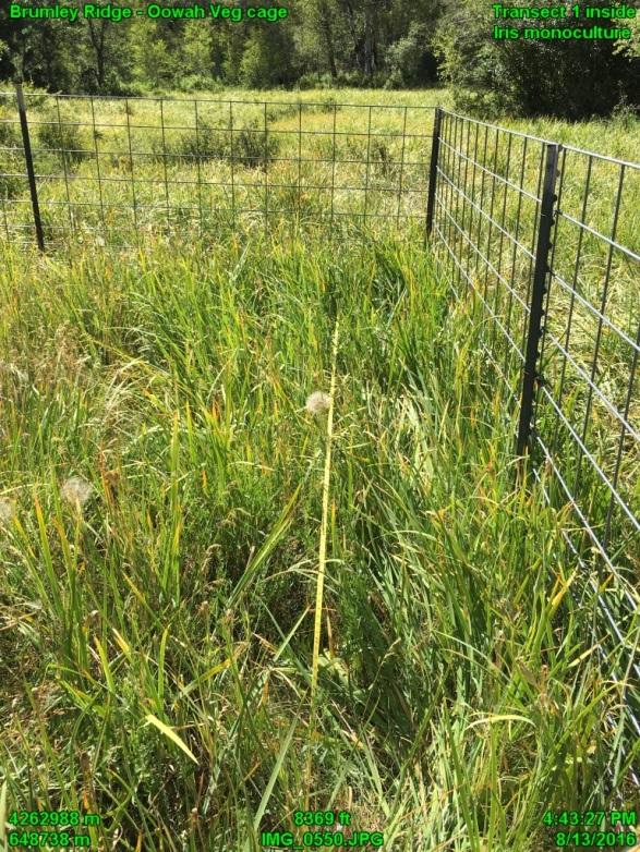
3 Fig. 3 (08/31/2012) Transect 1, outsid Fig. 5 (08/31/2012) Transect 1 inside Fig. 4 (08/13/2016) Transect 1 outside Fig. 6 (08/13/2016) Transect 1 inside


 2' 10")

4 Fig. 7 (08/31/2012) 2' headcut, near cage Fig. 9 (08/31/2012) Heavily-grazed opening w. cage Fig. 8 (08/13/2016) 2' headcut, near cage Fig. 10 (08/13/2016) Heavily-grazed opening w. cage
5 Plants: cover (%) - Top layer Table A-1 Inside Oowah Bench Exclosure August 13, 2016 cover (%) - All layers # Two most common species Native Exotic unk Native Exotic unk Native Exotic unk grass Achnatherum nelsonii forbs Iris missouriensis, Machaeranthera sp. Totals Ground cover %: Bare Rock Litter Moss, lichen, biol. crust Table A-2 Inside 2016 % cover # times intercepted Total Columbia needlegrass Achnatherum nelsonii 8 g Rocky Mountain iris Iris missouriensis 45 f Tansy aster Machaeranthera? 22 f Trailing fleabane Erigeron flagellaris 7 f Cinquefoil Potentilla sp. 3 f Yellow salsify Tragopogon dubius 5 f Yarrow Achillea millefolium 3 f Unknown forb (collected) PF01 2 f unknown forb unknown forb 2 f 1 2 2
6 Table B-1 Inside Oowah Bench Exclosure August 31, 2012 Plants: Cover (%) - Top layer Cover (%) - All layers # Two most common species Poa pratensis grass-like plants Native Exotic unk Native Exotic unk Native Exotic unk Poa pratensis Juncus sp. forbs Totals Ground Bare Rock Litter cover %: Table B-2 Inside 2012 % cover # times intercepted Iris missouriensis, Achillea millefolium Tot Kentucky bluegrass Poa pratensis 50 g Rush Juncus sp. 3.3 gl Rocky Mountain iris Iris missouriensis 53 f Yarrow Achillea millefolium 20 f Yellow salsify Tragopogon dubius 13 f Fleabane Erigeron sp. 6.7 f unknown forb 6.7 f Trailing fleabane Erigeron flagellaris 3.3 f Alfalfa Medicago sativa 3.3 f 1 3 2
7 Plants: cover (%) - Top layer Table C-1 Outside Oowah Bench Exclosure August 13, 2016 cover (%) - All layers # Two most common species Native Exotic unk Native Exotic unk Native Exotic unk Poa pratensis Poa pratensis grass-like plants forbs Totals Ground cover %: Juncus arcticus balticus Iris missouriensis, (Machaeranthera? AND Taraxacum ficinale Equal numbers) Bare Rock Litter Moss, lichen, biol. crust Table C-2 Outside, August 13, 2016 % cover # times intercepted Total Kentucky bluegrass Poa pratensis 57 g Baltic rush Juncus balticus 5 gl Rocky Mountain iris Iris missouriensis 73 f Tansy aster Machaeranthera sp. 8 f Common dandelion Taraxacum ficinale 8 f unknown forb 7 f Unknown forb (PF01) 5 f Yarrow Achillea millefolium 2 f 1 2 1
8 Table D-1 Outside Oowah Bench Exclosure August 31, 2012 Plants: Cover (%) - Top layer Cover (%) - All layers # Two most common species Poa pratensis Other grass Native Exotic unk Native Exotic unk Native Exotic unk Poa pratensis Unknown grass forbs Totals Ground cover %: Iris missouriensis, Machaeranthera sp. Bare Rock Litter Biological crust Table D-2 Outside, August 31, 2012 % cover # times intercepted Total Kentucky bluegrass Poa pratensis 40 g unknown grass 3.3 g Rocky Mountain iris Iris missouriensis 63 f Tansyaster Machaeranthera sp. 13 f Yarrow Achillea millefolium 3.3 f Yellow salsify Tragopogon dubius 3.3 f 1 4 3
9 Table E Oowah Bench Plant Plant species (1) intercepted on transect; (2) present w/in 16 X16 areas inside and outside August 13, 2016 Found: Intercepted INSIDE Intercepted OUTSIDE Within INSIDE Transect Area (16 x 16 ) Within OUTSIDE Transect Area (16 x 16 ) Tree Shrub Grass Grass-like Forb Achnatherum nelsonii Poa pratensis Bromus inermis Juncus balticus Iris missouriensis, Erigeron flagellaris, Potentilla sp., Tragopogon dubius, Achillea millefolium, unknown forb, PF01 Iris missouriensis, Taraxacum ficinale, unknown forb, Machaeranthera sp., Achillea millefolium Symphoricarpos oreophilus, Galium sp. [Note: no additional species beyond those intercepted were seen within the 16 X 16 outside transect area ] August 31, 2012 Found: Intercepted INSIDE Intercepted OUTSIDE Within INSIDE Transect Area (16' x 16'). Within OUTSIDE Transect Area (16' x 16'). Tree Shrub Grass Forb Populus tremuloides Juncus balticus Juncus balticus Poa pratensis Poa pratensis, Unknown grass Poa pratensis Poa pratensis, Poaceae sp. Iris missouriensis, Achillea millefolium, Tragopogon dubius, Potentilla sp., Unknown forb, Erigeron flagellaris, Iris missouriensis, Achillea millefolium, Tragopogon dubius Stenogonum salsuginosum, Erigeron sp., Viola sp., Machaeranthera sp, Taraxacum ficinale, Potentilla sp. Galium sp., Medicago sativa Trifolium sp., Polygonum douglasii, Tragopogon dubius, Potentilla sp., Arabis sp., Viola sp.
Kicking the Alpine Plants Out Mountain Goat Wallows In Mount Peale Research Natural Area (La Sal Mountains, Utah)
") Kicking the Alpine Plants Out Mountain Goat Wallows In Mount Peale Research Natural Area (La Sal Mountains, Utah) Marc Coles-Ritchie, Grand Canyon Trust November 21, 2017 Mountain goats are digging up
Kicking the Alpine Plants Out Mountain Goat Wallows In Mount Peale Research Natural Area (La Sal Mountains, Utah) Marc Coles-Ritchie, Grand Canyon Trust November 21, 2017 Mountain goats are digging up
Changes in vegetation at Lawrence Memorial Grasslands Preserve from
 Changes in vegetation at Lawrence Memorial Grasslands Preserve from -8 Introduction Adrien Elseroad and Nathan Emery The Nature Conservancy February 9 The Lawrence Memorial Grasslands is a 38-acre preserve
PERSISTENCE OF LEGUMES IN DEHESA SYSTEM: INFLUENCE ON PRODUCTIVITY AND PASTURE QUALITY
 PERSISTENCE OF LEGUMES IN DEHESA SYSTEM: INFLUENCE ON PRODUCTIVITY AND PASTURE QUALITY Ana Hernández-Esteban, María Lourdes López-Díaz, Yonatan Cáceres, Gerardo Moreno Instituto de Investigación de la
Chapter 8: Colorado Plateau State Highway 141, Dove Creek to Naturita
 State Highway 141 Dove Creek to (61 miles) Summary: Highway 141 heads north from US Highway 491 about two miles northwest of the town of Dove Creek. Initially, the highway runs through gently rolling farming
APPENDIX A Data Sheets and Sample Site Photographs
 APPENDIX A Data Sheets and Sample Site Photographs Appendix C - Page 41 Seward Highway MP 99-105 Anchorage August 8, 2006 DOT&PF 1 RAC/EMC none none Southcentral Alaska N N N N N N Hydrology - the winter
1.15 TONGARIRO GEOTHERMAL FIELD. List of Geothermal Sites. Te Maari Craters. Emerald Lakes. Contract Report No. 2348
 1.15 TONGARIRO GEOTHERMAL FIELD List of Geothermal Sites TGV01 TGV02 TGV03 TGV04 Te Maari Craters Ketetahi Emerald Lakes Red Crater 2011 452 TGV01 Te Maari Craters 0508 WILDNZ www.wildlands.co.nz ± ± 0
The following criteria were used to identify Benchmark Areas:
 7.0 BENCHMARK AREAS The Churn Creek Protected Area offers a significant opportunity to learn more about how grassland ecosystems function. One of the key tools that will be used to monitor larger grassland
IMPORTANT PLANT AREA NOMINATION FORM MONTANA. Nominated Site Name: Big Sheep Creek Basin Important Plant Area (IPA)
") IMPORTANT PLANT AREA NOMINATION FORM MONTANA Nominated Site Name: Big Sheep Creek Basin Important Plant Area (IPA) General Location: Big Sheep Creek Basin is a located between the Beaverhead (on the west)
IMPORTANT PLANT AREA NOMINATION FORM MONTANA Nominated Site Name: Big Sheep Creek Basin Important Plant Area (IPA) General Location: Big Sheep Creek Basin is a located between the Beaverhead (on the west)
Environmental Statement South Kyle Wind Farm August 2013
 Appendix 12.5: Quadrat Data from the National Vegetation Classification Survey 1.1 Introduction 1 This Appendix presents a list of the National Vegetation Classification (NVC) communities identified within
Non-Native Plant Inventory: Kenai Trails
 Non-Native Plant Inventory: Kenai Trails M.E. Shephard photo 1 R.L. DeVelice, Vegetation Ecologist USDA Forest Service, Chugach National Forest 3301 C Street, Suite 300 Anchorage, Alaska 99503-3998 1 Close-up
Spotlight surveys for Greater Gliders at scheduled harvesting coupes near Bendoc in East Gippsland
 Spotlight surveys for Greater Gliders at scheduled harvesting coupes near Bendoc in East Gippsland Coupes surveyed: District Coupe Number Coupe Name Bendoc 890-508-0001 Snail Nails Bendoc 890-508-0019
RANGELAND ECOLOGY AND RARE PLANT MONITORING IN WILLMORE WILDERNESS PARK
 RANGELAND ECOLOGY AND RARE PLANT MONITORING IN WILLMORE WILDERNESS PARK Progress Report for Foothills Model Forest Project Leader Cam Lane Contributions by Michael Willoughby, Joyce Gould, Lorna Allen,
Seed production of native grasses and herbs in Austria
 Seed production of native grasses and herbs in Austria B. Krautzer & A. Blaschka Agricultural Research and Education Centre Raumberg-Gumpenstein, Austria Ecological Restoration and Sustainable Development
BELLHOUSE PROVINCIAL PARK
 BELLHOUSE PROVINCIAL PARK PURPOSE STATEMENT AND ZONING PLAN March 2003 1 BELLHOUSE PROVINCIAL PARK Purpose Statement and Zoning Plan Primary Role The primary role of Bellhouse Provincial Park is to protect
Wicklow Mountains Path Survey
 Wicklow Mountains Path Survey Glenmacnass Tonelagee Start to Finish: O 114 030 to O 085 016 Altitude (lowest highest): 370m 817m Weather: Sunny day, hot Access: Military Road, Glenmacnass Surveyed by:
Page 1 of 5. SX45M Torpoint Ferry area SX4455 and SX th March 2014 I J Bennallick, M J Stribley, M & T Atkinson
 Species grid ref Location Notes Achillea millefolium SX440551 KING STREET, TORPOINT ALONG ROADSIDES AND VERGES Achillea millefolium SX445549 TORPOINT, SOUTH OF FERRY TERMINAL AREA ALONG EDGE OF ESTUARY
KIT 5 FAUNA AND FLORA IN GRAZED LANDSCAPES: INCREASER AND DECREASER SPECIES
 KIT 5 FAUNA AND FLORA IN GRAZED LANDSCAPES: INCREASER AND DECREASER SPECIES Acknowledgments This workshop series has been developed by the Biodiversity and Ecosystem Sciences Unit, Environment and Resource
IMPORTANT PLANT AREA NOMINATION FORM MONTANA. Nominated Site Name: South Pryor Mountains Important Plant Area (IPA)
") IMPORTANT PLANT AREA NOMINATION FORM MONTANA Nominated Site Name: South Pryor Mountains Important Plant Area (IPA) General Location: The South Pryor Mountains IPA is located between the Bighorn River on
IMPORTANT PLANT AREA NOMINATION FORM MONTANA Nominated Site Name: South Pryor Mountains Important Plant Area (IPA) General Location: The South Pryor Mountains IPA is located between the Bighorn River on
8. VEGETATION AND FAUNA
 8. VEGETATION AND FAUNA 8.1 INTRODUCTION The original native vegetation within the Little River Catchment varied according to geology, soil type, moisture and depth, temperature, rainfall, fire regime,
FOURMILE CANYON CREEK PARK Management Plan
 ~J ~l I),.:t '" FOURMILE CANYON CREEK PARK Management Plan LOCATION AND ACCESS Fourmile Canyon Creek Park is located west of Bow Mountain Subdivision. Access to the area is via Pinto Drive in the Bow Mountain
LEAVENWORTH ADVENTURE PARK PLANT SURVEY REPORT PREPARED FOR: DAVID MOFFET D/R/ MOFFET & ASSOCIATES 7900 SE 28 TH ST, SUITE 236 MERCER ISLAND, WA 98040
 LEAVENWORTH ADVENTURE PARK PLANT SURVEY REPORT PREPARED FOR: DAVID MOFFET D/R/ MOFFET & ASSOCIATES 7900 SE 28 TH ST, SUITE 236 MERCER ISLAND, WA 98040 PREPARED BY: GRETTE ASSOCIATES LLC 151 SOUTH WORTHEN,
FRIENDS OF THE DUNES Coastal Development Permit Application Notice
 FRIENDS OF THE DUNES Coastal Development Permit Application Notice Friends of the Dunes has submitted an application to the Humboldt County Planning Department for a Coastal Development Permit (CDP) to
PRIORITY HABITAT SURVEY 2017 SWALEDALE. Summary. July 2018
 PRIORITY HABITAT SURVEY 2017 SWALEDALE Summary July 2018 Conservation & Monitoring Report No: Lead Author(s): Tony Serjeant & Sue Thurley Incorporating comments from: Gary Smith & Gordon Haycock (16/07/18)
Georgia Coastal Ecosystems Long Term Ecological Research Project Marsh Hammock Research 2008
 Georgia Coastal Ecosystems Long Term Ecological Research Project Marsh Hammock Research 2008 Participating Investigators: M. Alber 1, C. Alexander 2, S. Pennings 3, S. Joye 1, C. Meile 1, A. Burd 1, W.
DIXIE HIGHWAY Region of Peel NAI Area # 1304, 1320, 2449, 2625, 3961
 DIXIE HIGHWAY 407 1 Region of Peel NAI Area # 1304, 1320, 2449, 2625, 3961 Toronto and Region Conservation Authority City of Brampton Size: 36 hectares Watershed: Etobicoke Creek Con 4 E, Lots 13, 14 Ownership:
The Small Swale Resource Overview
 The Small Swale Resource Overview Prepared for: City of Saskatoon Community Services Department City Planning Branch Prepared by: Stantec Consulting Ltd. #100 75 24 th Street East Saskatoon, Saskatchewan
OREsome Botanical Surveys Site dossier Coldberry mine and hushes
 OREsome Botanical Surveys Site dossier Coldberry mine and hushes SAM list entry: 1015863 Grid ref: NY9428 County: County Durham Parishes: Middleton in Teesdale, Newbiggin Altitude: 340-510m Habitats: Open
David Prevedel photograph collection.,
 David Prevedel photograph collection., 1900-2010 Overview of the Collection Creator Prevedel, David A. Title David Prevedel photograph collection. Dates 1900-2010 (inclusive) 1900 2010 Quantity 4 Boxes,
ASSESSMENT AND PRIORITIZATION OF MEADOWS IN THE GOLDEN TROUT WILDERNESS
 ASSESSMENT AND PRIORITIZATION OF MEADOWS IN THE GOLDEN TROUT WILDERNESS December 2014 A report submitted to CalTrout and supported by the National Fish and Wildlife Foundation Purpose: to evaluate and
EXPLORING BIOMES IN GORONGOSA NATIONAL PARK
 EXPLORING BIOMES IN GORONGOSA NATIONAL PARK ABOUT THIS WORKSHEET This worksheet complements the Click and Learn Gorongosa National Park Interactive Map (http://www.hhmi.org/biointeractive/gorongosa-national-park-interactive-map),
Region 1 Piney Woods
 Region 1 Piney Woods Piney Woods 1. This ecoregion is found in East Texas. 2. Climate: average annual rainfall of 36 to 50 inches is fairly uniformly distributed throughout the year, and humidity and temperatures
GOLDEN BACKCOUNTRY RECREATION ADVISORY COMMITTEE (GBRAC)
") GOLDEN BACKCOUNTRY RECREATION ADVISORY COMMITTEE (GBRAC) MINUTES from November 1, 2006 Meeting Attending: Sector / Stakeholder GBRAC Commercial Aerial Motorized Sector GBRAC Habitat Protection; Sport Fishing
GOLDEN BACKCOUNTRY RECREATION ADVISORY COMMITTEE (GBRAC) MINUTES from November 1, 2006 Meeting Attending: Sector / Stakeholder GBRAC Commercial Aerial Motorized Sector GBRAC Habitat Protection; Sport Fishing
Yorkshire Dales classification of protected areas into IUCN Management Categories. Mark Fisher, November 2013 Wildland Research Institute
 Yorkshire Dales classification of protected areas into IUCN Management Categories Mark Fisher, November 2013 Wildland Research Institute Ingleborough National Nature Reserve Nesting of protected areas
A COMPARISON OF SURFACE IMPACT BY HIKING AND HORSEBACK RIDING ON FOUR TRAIL SURFACES IN GREAT SMOKY MOUNTAINS NATIONAL PARK
 A COMPARISON OF SURFACE IMPACT BY HIKING AND HORSEBACK RIDING ON FOUR TRAIL SURFACES IN GREAT SMOKY MOUNTAINS NATIONAL PARK Paul Whittaker Susan Brat ton U.S. Department of the Interior National Park Service,
Assessing ungulates role in riparian hummocking on three national forests in southern Utah
 Honors Theses Geology - Environmental Studies Spring 2015 Assessing ungulates role in riparian hummocking on three national forests in southern Utah Collin W. Smith Penrose Library, Whitman College Permanent
CONTENTS. 31 THE TRAILS See next page for a complete listing of all trails and a locator map. Trail descriptions begin on page 31.
 CONTENTS Page Topic 6 Trail List 7 Trail Locator Map 8 Trails Listed by Dificulty 9 Trail Ratings Deined 11 INTRODUCTION 11 Using this Book 12 The Right Trail for You 13 About Moab 15 Utah OHV Laws and
Access to the site is obtainable from the paved driveway leading to the MWD facility.
 County of Riverside Public Safety Enterprise Communication Project Appendix A: Candidate Site Descriptions Overview The site is located adjacent to a Metropolitan Water District (MWD) facility on El Sobrante
Biodiversity Offset Strategy
 JUNE 2017 unit 18, level 3, 21 marystsurry hills nsw 2010 australia t (02) 8202 8333 www.nghenvironmental.com.au e ngh@nghenvironmental.com.au suite 1, 216 carp st (po box 470) begansw 2550 australia t
Scientific journal Title of paper Journal name Year / Volume / Pages
 CURRICULUM VITAE 1. Family Name: Sherifi 2. First Name: Enver 3. Nationality: Albanian 4. Date of Birth 13.06.1954 5. Gender: Male 6. Contact details: Email: e_sherifi@yahoo.com Tel: +37744 154 124 enver.sherifi@gmail.com
MOUNTAIN GOAT HERD UNIT MANAGEMENT PLAN Wildlife Management Unit #13 La Sal Mountains June 2013
 1 MOUNTAIN GOAT HERD UNIT MANAGEMENT PLAN Wildlife Management Unit #13 La Sal Mountains June 2013 BOUNDARY DESCRIPTION Grand and San Juan counties - Boundary begins at the junction of I-70 and the Green
The California / Nevada GLORIA Project: Status, Methodology, Data & Future Plans Death Valley National Park, 2013 Initial Survey Report
 The California / Nevada GLORIA Project: Status, Methodology, Data & Future Plans Death Valley National Park, 2013 Initial Survey Report Adelia Barber, GLORIA California July 2014 Summary of GLORIA activities
2.0 Physical Characteristics
 _ 2.0 Physical Characteristics 2.1 Existing Land Use for the Project The site is comprised of approximately 114 acres bounded by Highway 101 to the north, the existing town of Los Alamos to the east, State
Planning Wildlife Crossings in Canada's Mountain Parks SESSION: Highway Mitigation: new insights for practitioners
 Planning Wildlife Crossings in Canada's Mountain Parks ID95 SESSION: Highway Mitigation: new insights for practitioners Trevor Kinley, Project Manager Lake Louise Yoho Kootenay Field Unit, Parks Canada
Ep156 Miller's Grove (2.3 ha) TL
 TL") Ep156 Miller's Grove (2.3 ha) TL 520040 Miller's Grove is located just within the extreme eastern boundary of Ongar Great Park, a medieval deer park dating from the 11 th century. This broadleaved woodland
Ep156 Miller's Grove (2.3 ha) TL 520040 Miller's Grove is located just within the extreme eastern boundary of Ongar Great Park, a medieval deer park dating from the 11 th century. This broadleaved woodland
Cover of fallen tree leaves reduces herbaceous productivity under poplars in silvopastoral systems
 Facultad de Agronomía Universidad de Buenos Aires Cover of fallen tree leaves reduces herbaceous productivity under poplars in silvopastoral systems borodows@gmail.com ARGENTINA Monlezun, S.J., Cornaglia,
Biol (Fig 6.13 Begon et al) Logistic growth in wildebeest population
 Logistic growth in wildebeest population") Biol 303 1 Interspecific Competition Outline Intraspecific competition = density dependence Intraspecific and interspecific competition Limiting resources Interference vs exploitation Effects on population
Biol 303 1 Interspecific Competition Outline Intraspecific competition = density dependence Intraspecific and interspecific competition Limiting resources Interference vs exploitation Effects on population
This Passport: Revised October 20, 2017, EAM # Discovering the Trails of Penfield, NY
 This Passport: Revised October 20, 2017, EAM #161922 Discovering the Trails of Penfield, NY The Town of Penfield is fortunate to have a wide variety of natural resources which make for many unique and
KP Lasnaya 1 River
 KP 370.2 Lasnaya 1 River The Lasnaya 1 River crossing is protected by Reno mattings and a gabion wall on the north bank (Photo 1). The south bank consists of natural river gravel deposits on top of Reno
The Sand Ridge - Tulare Lake Conservation Report proposes the following recommendations:
 Introduction Creighton Ranch. Pixley National Wildlife Refuge. Allensworth State Historic Park. Sand Ridge. Deer Creek. Located in the Tulare Lake Basin, the Sand-Ridge - Tulare Lake Planning Area features
Summary of prescribed fires in Prince Albert National Park 2015
 Summary of prescribed fires in Prince Albert National Park 2015 Prince Albert National Park conducted four controlled fires in spring 2015, plus an additional fire in October. Fuel Management for Hazard
State Beaches Rare Plant Surveys by California Native Plant Society Rare Plant Survey Committee, Spring 2011
 State Beaches Rare Plant Surveys by California Native Plant Society Rare Plant Survey Committee, Spring 2011 Frank Landis, PhD August 16, 2011 SUMMARY Between March 18 and May 6, 2011, California Native
Reservoir Tin workings
 The workings are quite over-grown and covered in moss, suggesting that they date to the earliest period of mining. This is supported by the fact that their head race was cut off by the reservoir (D49/47)
MINIMUM REQUIREMENTS DECISION GUIDE WORKSHEETS
 ARTHUR CARHART NATIONAL WILDERNESS TRAINING CENTER MINIMUM REQUIREMENTS DECISION GUIDE WORKSHEETS Prescribed burning of islands within Okefenokee Wilderness Area.... except as necessary to meet minimum
WALKER RANCH MANAGEMENT PLAN
 WALKER RANCH MANAGEMENT PLAN Boulder County Parks and Open Space Walker Ranch Management Plan July 2013 The Walker Ranch Management Plan provides guidance to Boulder County Parks and Open Space on management
Report on the 2016 Survey of Exotic Plants along Northwest Territories Highways
 Report on the Survey of Exotic Plants along Northwest Territories Highways By Michael J. Oldham 1 and Mireille Delisle-Oldham 2 March 2017 1 Ontario Natural Heritage Information Centre, Science and Research
Aletes humilis Larimer Aletes
 The Colorado Rare Plant Technical Committee presents: 4th Annual Rare Plant Symposium Sponsored by: Colorado Native Plant Society University of Colorado Herbarium US Fish and Wildlife Service Colorado
SeagrassNet Monitoring in Great Bay, New Hampshire, 2016
 University of New Hampshire University of New Hampshire Scholars' Repository PREP Reports & Publications Institute for the Study of Earth, Oceans, and Space (EOS) 9-28-2017 SeagrassNet Monitoring in Great
VISUAL Impact Assessment
 5.0 Existing Landscape Character TO GOULBURN FEDERAL HIGHWAY 5.1 Landscape Character Units Generally one of the first steps in carrying out a landscape and visual assessment is to identify and map the
Wicklow Mountains Path Survey
 Wicklow Mountains Path Survey Ballinacor Croaghanmoira Fananierin Start to Finish: T 11723 86602 to T 11175 89057 Altitude (lowest highest): 385m 664m Weather: Hot Access: Coolgarrow forest entrance Surveyed
SYNOPSIS WEATHER AND SNOWPACK
 Peak 6996 Avalanche Fatality Incident Report Glacier National Park, MT Date of Avalanche: 31 March 2010 Date of Investigation: 2 April 2010 Investigation Team: Erich Peitzsch (USGS), Ted Steiner (Chugach
Photopoint Monitoring in the Adirondack Alpine Zone
 Photopoint Monitoring in the Adirondack Alpine Zone Julia Goren (PI) and Seth Jones Adirondack High Peaks Summit Steward Program Adirondack Mountain Club summit@adk.org PO Box 867, Lake Placid, NY 12946
GIFFORD PINCHOT NATIONAL FOREST
 GIFFORD PINCHOT NATIONAL FOREST 9341 Wright Meadow 93 Spencer Meadow Spencer Butte 4247' 30 30A 19 24 80 31C Lewis River Lower Falls 5 Quartz Creek 90 Taidnapam Falls Upper Falls 31 Spencer Peak 3861'
Fold the lower corner up to touch the vertical middle crease. The fold starts from the opposite corner.
 CARBUNCLE Start with a square coloured side up. 1 3 2 Fold and unfold the square in half lengthwise and diagonally along all axes. Fold the lower corner up to touch the vertical middle crease. The fold
You can learn more about the trail camera project and help identify animals at WildCam Gorongosa (
 INTRODUCTION Gorongosa National Park is a 1,570-square-mile protected area in Mozambique. After several decades of war devastated Gorongosa s wildlife populations, park scientists and conservation managers
General Overview: Acreage:
 General Overview: The Beaver Creek Ranch is located on Beaver Creek in Shell Wyoming, at the base of the western slope of the Big Horn Mountains, one of the west s most spectacular back drops. With an
General Summer and Winter Views
 ENVIRONMENTAL INFORMATION REPORT VOLUME 4 APPENDIX 11. 2 General Summer and Winter Views Table of Contents Section APPENDIX 11.2 Page 1 General Views... 1-1 Tansy Lane, Portishead... 1-2 Galingale Way,
General Implementation
 Features 1 General Implementation Allow vehicle travel for the purposes of dispersed camping within 300 feet of designated Forest roads and motorized trails except for the fen areas identified above, and
Maya s Creek Crossing Hwy 17 N acres $185,000 Fort Davis, Texas
 Maya s Creek Crossing Hwy 17 N 14.98 acres $185,000 Fort Davis, Texas James King, Agent Office 432-426-2024 Cell 432-386-2821 James@KingLandWater.com King Land & Water LLC P.O. Box 109, 600 State Street,
San Juan Hut Systems Telluride To Moab Route Description. Adventure without the weight
 San Juan Hut Systems Telluride To Moab Route Description Due to the inaccuracies caused by varying calibrations in odometers, you may notice some inaccuracies in the mileages listed for the Standard Route
Theme: Predominately natural/natural appearing; rustic improvements to protect resources. Size*: 2,500 + acres Infrastructure**:
 Recreation Opportunity Spectrum (ROS) Classes The Recreation Opportunity Spectrum (ROS) provides a way to describe the variations in the degree of isolation from the sounds and influences of people, and
AND TRAMPLING EFFECTS OF HIKERS, MOTORCYCLES HORSES IN MEADOWS AND FORESTS. Journal of Applied Ecology (1978), 15, T. WEAVER AND D.
, 15, T. WEAVER AND D.") 0040794 Journal of Applied Ecology (1978), 15, 451-457 TRAMPLING EFFECTS OF HIKERS, MOTORCYCLES HORSES IN MEADOWS AND FORESTS AND T. WEAVER AND D. DALE Department ofbiology, Montana State University, Bozeman,
0040794 Journal of Applied Ecology (1978), 15, 451-457 TRAMPLING EFFECTS OF HIKERS, MOTORCYCLES HORSES IN MEADOWS AND FORESTS AND T. WEAVER AND D. DALE Department ofbiology, Montana State University, Bozeman,
STREAMWALKS REVISITED
 STREAMWALKS REVISITED Maggie A. Kendrick, Department of Earth Sciences, University of South Alabama, Mobile, AL, 36688. Email: mak0209@aol.com. The goal of my research is to have a system of streamwalks
A Flora of Valentine Eastern Sierra Reserve
 A Flora of Valentine Eastern Sierra Reserve Part I Valentine Camp Ann M. Howald Part II Sierra Nevada Aquatic Research Laboratory Bruce K. Orr and Ann M. Howald THE HERBARIUM Museum of Systematics and
Plants Of Southern Interior British Columbia And The Inland Northwest By Ray Coupe, Robert Parish READ ONLINE
 Plants Of Southern Interior British Columbia And The Inland Northwest By Ray Coupe, Robert Parish READ ONLINE Distribution of species: Pacific Northwest: British Columbia to California, and Plants of Southern
Draft Protocol for Monitoring the Effectiveness of Mountain Goat Winter Ranges
 Draft Protocol for Monitoring the Effectiveness of Mountain Goat Winter Ranges DRAFT Version 1.0 March 2009 DRAFT Protocol for Monitoring the Effectiveness of Mountain Goat Winter Ranges 1 Citation: Province
HIGH COUNTRY L-BAR RANCH
 HIGH COUNTRY L-BAR RANCH Sandoval and mckinley counties N e w m e x i c o Jim Haworth, Ranch Team Lead Broker ~ 505-235-5236 3613 NMSR 528 NW, Ste. H, Albuquerque, NM 87114 505-792-3713 www.wwrealty.com
Our Mission. Discover the many states of California. Chino Hills State Park 1879 Jackson Street Riverside, Ca (951)
") Chino Hills State Park Our Mission The mission of the California Department of Parks and Recreation is to provide for the health, inspiration and education of the people of California by helping to preserve
Chino Hills State Park Our Mission The mission of the California Department of Parks and Recreation is to provide for the health, inspiration and education of the people of California by helping to preserve
THE INTERNATIONAL SNOW LEOPARD TRUST
 INTERACTIONS BETWEEN LIVESTOCK AND LADAKH URIAL (Ovis vignei vignei) FINAL REPORT Submitted to THE INTERNATIONAL SNOW LEOPARD TRUST By BINDU RAGHAVAN YASH VEER BHATNAGAR QAMAR QURESHI INTRODUCTION AND
Rock Creek State Park
 Rock Creek State Park Rock Creek State Park Rock Creek State Park, located five miles west of Grinnell, consists of a large man-made lake and a surrounding fringe of land. There are several access points
Ep166 Dewley Wood (6.4 ha) TL
 TL") Ep166 Dewley Wood (6.4 ha) TL 528045 This large ancient wood contains a canopy of predominantly Pedunculate Oak (Quercus robur) standards, occasional Ash (Fraxinus excelsior) coppice with Hornbeam (Carpinus
Ep166 Dewley Wood (6.4 ha) TL 528045 This large ancient wood contains a canopy of predominantly Pedunculate Oak (Quercus robur) standards, occasional Ash (Fraxinus excelsior) coppice with Hornbeam (Carpinus
Trail Phasing Plan. Note: Trails in the Clear Creek Canyon area (Segments will be finalized in the future to minimize wildlife impacts
 Note: Trails in the Clear Creek Canyon area (Segments 2 5 and a future JCOS connection) will be finalized in the future to minimize wildlife impacts Trail Phasing Plan P Parking 3 Easy Trail Intermediate
ENVIRONMENTAL HAZARDS OF AVALANCHES: PRELIMINARY RESEARCH IN GLACIER NATIONAL PARK
 ENVIRONMENTAL HAZARDS OF AVALANCHES: PRELIMINARY RESEARCH IN GLACIER NATIONAL PARK Site Focus: Balu Pass, Glacier National Park, B.C. Avalanche path near Balu Pass. (Photo Courtesy of: www.leelau.net/2007/rogerspass/day1/1)
November 8, Members: Ms. Eileen Mackin-Getzoff Chair Dr. Yarrow Nelson Vice Chair Mr. Robert Carr Mr. Ryan Andrews Mr.
 - Jim Suty, President 15131 Garcal Drive San Jose, CA 95127 805-994-9309 E-mail: jim@oceanodunes.org www.oceanodunes.org November 8, 2017 San Luis Obispo County Air Pollution Control District Hearing Board
BLANKET CREEK PROVINCIAL PARK
 BLANKET CREEK PROVINCIAL PARK PURPOSE STATEMENT AND ZONING PLAN February 2003 BLANKET CREEK PROVINCIAL PARK Purpose Statement and Zoning Plan Primary Role The primary role of Blanket Creek Park is to maintain
Marble: 7:09 am Creede: 1:01 pm Today s Airtime: 5.8 hrs Cartographic length 351 miles. Total PIC Time: Total Logged Time 1623.
 Monday, September 11, 2017 Cobra flight #600, PIC #613, 1 landings Misty Meadows, Clear Creek Falls, Lost Lakes, Ute Ridge, Silex, Rio Grande Pyramid, Hossick Lake, Pagosa Peak, Chama Headwaters and Falls,
U.S. Army Corps of Engineers Fiscal Year 2013 Handshake Program Application
 U.S. Army Corps of Engineers Fiscal Year 2013 Handshake Program Application Please review instructions before completing application! Corps Lake/Project Name:Rathbun Lake/ North Shore Trail Handshake Proposal
MORGAN CREEK GREENWAY Final Report APPENDICES
 APPENDICES MORGAN CREEK GREENWAY Appendix A Photos of Existing Conditions in Trail Corridor Photos of existing conditions Main trail corridor - February 2009 Photos of existing conditions south bank Morgan
MONITORING THE EFFECTIVENESS OF UNGULATE WINTER RANGES ESTABLISHED FOR MOUNTAIN GOATS: ESTABLISHING MONITORING PROTOCOLS AND ECOLOGICAL BASELINES
 MONITORING THE EFFECTIVENESS OF UNGULATE WINTER RANGES ESTABLISHED FOR MOUNTAIN GOATS: ESTABLISHING MONITORING PROTOCOLS AND ECOLOGICAL BASELINES PREPARED BY Steven F. Wilson, Ph.D., R.P.Bio. PREPARED
OBSERVATIONS OF LYNX: No observations of lynx were recorded at this site.
 SURVEY DATES: Snow-tracking stint 1: 6 and 7 January 2001 Snow-tracking stint 2: 5 February 2001 Remote camera active: 20 days (7 January 2001-27 January 2001; malfunction precluded full camera session)
fact sheet fact sheet Minnippi Masterplan. Squirrel Glider Habitat Public Open Space Medium Density Proposed Public Golf Course Medium Density
 P ROJ E C T OV E RV I E W Minnippi comprises a Brisbane City Council owned public golf course, conservation areas and new housing to be developed on a total of 125 hectares between Creek Road, Fursden
Available online at WSN 83 (2017) EISSN SHORT COMMUNICATION
 EISSN SHORT COMMUNICATION") Available online at www.worldscientificnews.com WSN 83 (2017) 235-239 EISSN 2392-2192 SHORT COMMUNICATION Materials to the knowledge of Polish sawflies. The genus Dolerus Panzer, 1801 (Hymenoptera, Symphyta,
Available online at www.worldscientificnews.com WSN 83 (2017) 235-239 EISSN 2392-2192 SHORT COMMUNICATION Materials to the knowledge of Polish sawflies. The genus Dolerus Panzer, 1801 (Hymenoptera, Symphyta,
Tenure Management Plan. Wandering Wheels
 Tenure Management Plan Wandering Wheels Amendment Application February 2018 TABLE OF CONTENTS Section A - Project Overview Section B - Project Description Background 3 Location 4 Trail Access 4 Projected
Viola selkirkii (Selkirk s violet) Survey Report for the Pike and San Isabel National Forests Performed in June, 2010
 Survey Report for the Pike and San Isabel National Forests Performed in June, 2010") Viola selkirkii (Selkirk s violet) Survey Report for the Pike and San Isabel National Forests Performed in June, 2010 Closeup of Selkirk s violet in bloom. The diagnostic glassy hairs on the leaves are
Viola selkirkii (Selkirk s violet) Survey Report for the Pike and San Isabel National Forests Performed in June, 2010 Closeup of Selkirk s violet in bloom. The diagnostic glassy hairs on the leaves are
Assessing Your Trails, Keeping Them Safe and Enjoyable
 Jon Wood, PLA, ASLA Associate Vice President Stewart Bert Lynn, PLA, ASLA, LEED AP Project Manager Mecklenburg County Asset and Facility Management Assessing Your Trails, Keeping Them Safe and Enjoyable
County of Riverside - PSEC Project General Habitat Assessment Appendix A
 County of Riverside - PSEC Project General Habitat Assessment Appendix A Glen Avon Glen Avon The Glen Avon study area is located north of State Route 60 in the Jurupa Mountains, approximately 1 mile south
B10. Agate Beach State Recreation Site
 B10. Agate Beach State Recreation Site Location Within the City of Newport, just south of the Yaquina Head Outstanding Natural Area. The park is located along the west side of Highway 101 at the mouth
Mountain Goats and Winter Recreation November 17, 2011
 Mountain Goats and Winter Recreation November 17, 2011 Summary Mountain goats need protection from disruption and displacement in their winter feeding areas by motorized and non-motorized recreationists
RANGE EXTENSIONS FOR ERYTHRANTHE ARVENSIS AND E. HALLII (PHRYMACEAE)
") Nesom, G.L. 2016. Range extensions for Erythranthe arvensis and E. hallii (Phrymaceae). Phytoneuron 2016-80: 1 5. Published 12 December 2016. ISSN 2153 733X RANGE EXTENSIONS FOR ERYTHRANTHE ARVENSIS AND
Nesom, G.L. 2016. Range extensions for Erythranthe arvensis and E. hallii (Phrymaceae). Phytoneuron 2016-80: 1 5. Published 12 December 2016. ISSN 2153 733X RANGE EXTENSIONS FOR ERYTHRANTHE ARVENSIS AND
Robson Valley Avalanche Tract Mapping Project
 Robson Valley Avalanche Tract Mapping Project Prepared for: Chris Ritchie Ministry of Water Land and Air Protection 325 1011 4th Avenue Prince George, BC. V2L3H9 and Dale Seip Ministry of Forests 1011
AURORA WILDLIFE RESEARCH
 AURORA WILDLIFE RESEARCH Kim Poole 2305 Annable Rd. Nelson, BC, V1L 6K4 Canada Tel: (250) 825-4063; Fax: (250) 825-4073 e-mail: klpoole@shaw.ca 27 April 2005 Mike Gall Conservation Specialist and Glenn