PROTECTED NATURAL AREAS IN NORTHLAND, AND CARE STANDARDS FOR PROTECTED NATURAL AREAS
|
|
|
- Joanna Phoebe Bryant
- 5 years ago
- Views:
Transcription

1 PROTECTED NATURAL AREAS IN NORTHLAND, AND CARE STANDARDS FOR PROTECTED NATURAL AREAS SEPTEMBER 2008 Report No Prepared for: NORTHLAND REGIONAL COUNCIL PRIVATE BAG 9021 WHANGAREI 0140 WILDLAND CONSULTANTS LTD, WELLINGTON OFFICE, 11 PATIKI PLACE, TITAHI BAY, WELLINGTON 5022 Ph , Fax , Website HEAD OFFICE, 99 SALA STREET, P.O. BOX 7137, TE NGAE, ROTORUA Ph , Fax ,
2 EXECUTIVE SUMMARY This report uses available data to determine what proportion of Northland Region can be classed as Protected Natural Areas (PNA). A PNA is defined as an area of land that has formal legal status intended to protect indigenous ecosystems, vegetation, habitats, or species. Within the PNA network, different types of legislation provide different levels of protection. Some types of reserve, and areas looked after by community care groups, do not fit the definition of a PNA. A summary is provided of national and regional priorities for protection of natural values. In total, 13.75% of the Northland Region has some sort of legal protection. This equates to 2,067 sites covering 180,336.2 ha. Of that total, 1,905 sites (c.87% of the total number) covering 156,451 ha (c. 92% of the total area) are PNAs, as they have the legal mandate to conserve natural values. The remainder of the sites may protect natural values as a by-product of reservation (legal protection for other reasons than conservation of natural values) or through management without legal protection. Northland Region includes 24 ecological districts, of which 19 have been fully or partially surveyed. For 11 ecological districts, less than 10% of the total land area comprises PNAs. These are ordered from least area of PNA sites to highest; Otamatea, Tokatoka, Hokianga, Whangarei, Kaikohe, Rodney (part), Kerikeri, Tangihua, Pouto, Aupouri, and Waipu. Other ecological districts (Poor Knights, Three Kings, Manaia, Taranga) are nearly completely protected. Some of these ecological districts still contain a large proportion of indigenous vegetation in Acutely Threatened or Chronically Threatened Land Environments of New Zealand (LENZ) categories (Ministry for the Environment 2007a, 2007b). However, as a general rule, PNAs within ecological districts only include a small percentage of Acutely Threatened (1.7% over total region) and Chronically Threatened (4.2% over total region) land environments. The amount of indigenous vegetation remaining within ecological districts varies greatly. Using the Land Cover Database vs 2 (LCDB2), 11.9% of the Northland Region is a PNA, a further 5.8% is legally protected but not a PNA (i.e. the legislative mandate is not protection of natural values) or is being looked after by community or Landcare Groups. This leaves c.82% of Northland Region without any form of legal protection or care 1. There is considerable scope for further protection of natural values, as nearly 37% of Northland Region consists of indigenous landcover. The LCDB2 categories of native vegetation that require urgent protection are Alpine Gravel and Rock, Depleted Tussock Grassland, Estuarine Open Water and Fernland. Many other vegetation categories also warrant further protection. 1 Note that the numbers do not quite add up as the different mapping layers LCDB2, PNA, Regional Council Territory include variable amounts of estuarine and coastal environments.
3 The Department of Conservation manages 92% of the area covered by PNAs (144,089 ha), Queen Elizabeth II National Trust protects 4.2% (6,587 ha), Nga Whenua Rahui 2.2% (3,718 ha), and the Whangarei District Council has protected 1.5% (2,266 ha) by means of covenants. The number of PNAs managed by the different agencies are: DOC 802 sites (42% of the sites), Whangarei District Council 613 sites (32%), QEII Trust 475 sites (25%), and Nga Whenua Rahui 15 sites (0.8%). Within the Northland Region, 1,320 (283,947.8 ha) Natural Areas of Ecological Significance (NAES) were identified through Protected Natural Areas Programme surveys. In total, 506 NAES (37.39% of the area) are partially or fully protected by some mechanism. Of these, 444 NAES (85,535.9 ha or 31.5% of the area) are PNAs, either wholly or partially. A further 162 NAES (equalling 16,636 ha or 5.86% of the area) are partially or fully protected by mechanisms that may not protect natural values. Sixty-two percent of NAES are not protected or managed by any mechanism. Of those that are protected or managed (this includes legal protection but also efforts by community groups), nearly all NAES (98%) only have part of their total area protected. NAES can be protected by multiple mechanisms. Whangarei District Council (WDC) has required the covenanting of 613 areas, usually as part of sub-division processes, totalling 2,266.0 ha. Nearly 50% of them (24% by area) were not NAES identified in PNAP surveys. In total, 311 NAES are fully or partially protected by WDC covenants. A range of other mechanisms contribute to the conservation of natural values, but do not result in PNA status. These include community care groups, Council funded pest management projects, Government funded biodiversity projects, and Fish and Game reserves. The data for most of these mechanisms is often incomplete, contains errors, or in some cases is not available in a spatial (mapped) format. This limits how these data can be used. There is currently no consistent classification of ecological features within protected areas. Descriptions of ecological areas vary within and between organisations. The only nationwide classification of vegetation cover that is relatively consistent across the entire country is the LCDB2. A consistent nationwide approach to classifying and ranking natural areas is required. The extent of all natural areas, and all areas where management is undertaken to manage natural values, needs to be mapped as GIS layers to allow better comparison and analysis. There are no consistent standards of care between, and sometimes within, organisations. Few agencies have specified what the minimum standards of care should be, or have the means to enforce standards if they are present. Often management of PNAs can be hampered by lack of funds or other resources. General standards of care are suggested for different ecosystem types.
4 CONTENTS EXECUTIVE SUMMARY I 1. INTRODUCTION 1 2. PROJECT OBJECTIVES Existing protected natural areas Care standards 2 3. METHODS 2 4. DEFINITION OF PROTECTED NATURAL AREAS 2 5. PRIORITIES FOR PROTECTION National priorities for protecting rare and threatened biodiversity on private land (2007) Northland Protection Strategy (2001) Protected Natural Areas Programme ( ) Proportion of Ecological Districts threatened 9 6. PROTECTED NATURAL AREAS DOC administered lands, QEII covenants, and Nga Whenua Rahui Level of protection afforded by various acts Protection status of Natural Areas of Ecological Significance (NAES) Whangarei District Council Covenants OTHER PROTECTION MECHANISMS (NON-PNAS) Kaipara District Council Biodiversity Improvement Fund Northland Regional Council Community Pest Control Areas Northland Regional Council CoastCare Groups Fish and Game wetlands Landcare Groups Far North District Council significant natural areas Areas afforded some level of protection investment through the Biodiversity Condition and Advice Funds ECOLOGICAL FEATURES THAT OCCUR WITHIN PROTECTED AREAS Types of habitats protected as classified by LCDB Types of habitats protected under QEII Trust covenants INFORMATION GAPS AND ANOMALIES STANDARDS OF CARE Suggested standards of care Queen Elizabeth II covenants 57
5 11. RECOMMENDATIONS 57 ACKNOWLEDGMENTS 58 REFERENCES 58 APPENDICES 1. The originally rare ecosystems included in National Priority Three 2. Purposes and key definitions within various acts 3. Landcare Groups for which the extent of the lands they are working on have not been captured on a GIS database 4. GIS data layers not available as at 1 January Protected natural areas listed by ecological district 6. Natural areas of ecological significance identified in Protected Natural Area Programme surveys 7. List of areas of conservation lands for which part or all of the reserve boundaries overlap with boundaries of other types of Protected Natural Areas or management (e.g. QEII, Nga Whenua Rahui, etc) mapped in GIS layers 8. Natural areas of ecological significance without any level of protection or management 9. Glossary of terms FIGURES 1. Northland Ecological Districts and LENZ threat categories The extent of remaining indigenous vegetation and the relationship with the Acutely Threatened and Chronically Threatened LENZ Environments Protected natural areas in relation to extent of indigenous vegetation and natural areas of ecological significance Map of Coast Care Groups in Northland Region. 33 TABLES 1. Definition of a Protected Natural Area in Northland Regional Council Area 4 2. Northland Region ecological regions and districts Total area of each ecological district in Northland and proportion that falls within Acutely or Chronically Threatened LENZ environments sorted in order of most threatened. 9 4a. Area and number of Protected Natural Areas in Northland Region by reserve status 25 4b. Area and number of protected areas in Northland Region for which legislative mandate is not protection of natural values 26
6 4c. Area and number of DOC managed lands, QEII covenant or Nga Whenua Rahui land in Northland Region for which legislative mandate is protection of natural values Protection status of Natural Areas of Ecological Significance (NAES) in Northland Region Number of protection mechanisms per Natural Area of Ecological Significance (NAES) Number and extent of area protected by Whangarei Disctric Council covenants Number and extent of area protected by by Kaipara District Council Biodiversity Improvement Fund Projects Approved Community Pest Control Areas and NAES Area of Community Pest Control Areas (CPCAs) that are NAES List of Northland Region Coast Care Groups Fish and Game Wetlands and NAES New Zealand Fish and Game wetlands that are also a NAES Landcare Group areas and NAES Number of NAES contained within Landcare Group areas Proportion of Landcare Group areas by administration type, and the proportion of each that is also a NAES Far North District Council, Significant Natural Areas funding recipients Funds approved in various rounds for the Biodiversity Condition and Advice Funds , Types of organisations that successfully applied for funds List of indigenous and non-indigenous land use and landcover classifications used in the Landcover Database (LCDB2) 40 21a. Proportion of ecological eistrict currently protected, partially protected or not protected at all, and amount of native vegetation remaining b. Proportion of ecological district currently protected by PNA, with special attention to Acutely and Chronically Threatened LENZ categories c. Proportion of other protected areas in Northland Region Proportion, for which legislative mandate is not protection of natural values by, ecological district, with special attention to Acutely and Chronically Threatened LENZ categories a. LCDB2 native landcover or land-use types in Protected Natural Areas in each ecological district 46 22b. LCDB2 native landcover or land-use types protected by non-pna reserves or community care groups in each ecological district 46 22c. LCDB2 native land-cover or land-use types currently not afforded any protection in each ecological district and total of each land-cover type within Northland Region 47 22d. Area (ha) comprising Acutely or Chronically Threatened categories of LENZ for each LCDB2 native landcover or land-use class and summarised by ecological district Number of Queen Elizabeth II covenants in Northland Region by the main habitat type(s) (up to two) in each covenant Area (ha) of Queen Elizabeth II covenants in Northland Region by the main habitat type(s) (up to two) in each covenant Numbers of QEII covenants fenced in the Northland Region. 57
7 26. Adherence of QEII covenants to covenant conditions in Northland Region. 57 PROJECT TEAM Astrid van Meeuwen-Dijkgraaf, Wildland Consultants Ltd - report preparation. Sarah Beadel, Wildland Consultants Ltd - project overview and set up, peer review. Roger Bawden, Wildland Consultants Ltd - GIS. Stpehen Rate, Wildland Consultants Ltd - peer review. John Craig, Auckland Uniservices Ltd - peer review. Reviewed and approved for release by: Sarah Beadel Director Wildland Consultants Ltd Wildland Consultants Ltd 2008 This report has been produced by Wildland Consultants Ltd for Northland Regional Council. All copyright in this report is the property of Wildland Consultants Ltd and any unauthorised publication, reproduction, or adaptation of this report is a breach of that copyright.
8 1. INTRODUCTION Northland Regional Council would like to establish a baseline data set on the location, extent, and type of Protected Natural Areas (PNAs) in Northland. This data set and associated report will help guide Regional and District Policy Statement Objectives and work plans for the Regional Council and the local District Councils. Northland Regional Council (NRC) would also like to identify, in general terms, the existing levels of care in the various types of protected areas and to identify some minimum standards of care across all protected areas. 2. PROJECT OBJECTIVES 2.1 Existing protected natural areas Define Protected Natural Areas (PNAs). Collate existing GIS data on the location of all PNAs in Northland, e.g. DOC, QEII, Nga Whenua Rahui, and also data on other covenants, kiwi protection areas, Environment Fund areas, Biodiversity Condition Fund areas, Landcare Groups. Information on these latter groups is currently being pulled together in The Whole of Northland Project, a project which is to summarise biodiversity work in Northland jointly funded by Landcare Trust, NRC, DOC, and Biodiversity Advice Fund. Prepare a GIS map of PNAs in Northland using existing GIS data. Identify gaps in existing GIS layers. Use centrepoints for PNAs not mapped on existing GIS layers, if available, to help map the general location of PNAs. Calculate numbers and areas of each type of PNA (e.g. scenic reserves, conservation parks, QEII covenants, Nga Whenua Rahui). Undertake an analysis of the type of features that occur within the PNA network (e.g. are all ecosystem types represented, what are the most threatened land environments, what features were originally rare ecosystems, to what extent do the areas contribute to preserving biodiversity at a landscape scale by retaining habitat linkages, ecological sequences etc.). Identify anomalies. For example, the legal status of recreation reserves is not designed to protect indigenous ecosystems, vegetation, habitats, or species, even though some recreation reserves have significant ecological values (e.g. Te Paki Recreation Reserve). Another category is Esplanade Reserves which are primarily for public access rather than for ecological values, although some often have significant ecological values (e.g. coastal and lake margins.) 1 1
9 Identify private landowners such as forestry companies and farmers that may manage areas for natural values without formally protecting them. 2.2 Care standards Identify existing levels of care in natural areas, e.g. formal protection, fencing, pest animal control, pest plant control, and restoration. Identify levels of care related to: (i) types of protected areas; (ii) unprotected versus protected sites; (iii) levels of ecological significance. Develop minimum standards of care. This could extend to recommending different levels of care for various types of features, or based on the relative ecological values of the area. 3. METHODS All areas conforming to the definition of a PNA (see section 4 below and also Wildland Consultants Ltd 2002) were collated from existing databases. A spatial layer was developed in the Geographic Information System (GIS) ARCVIEW 3.1 from existing digital data provided by Department of Conservation (DOC), NRC, Whole of Northland Project, and QEII National Trust, and extracted from the Digital Cadastral Database (DCDB), as shown in Figure 3. Information on each site was recorded in an attribute table linked to the GIS layer (Tables in Appendix 5 Protected Natural Areas and Appendix 6 Significant Areas indentified by Protected Natural Areas Programme (PNAP) surveys). The attributes table includes site name, protection status, DOC Conservation Management Strategy site number (where applicable), and area (hectares). Nearly all of the layers used have limitations and some of the data is based on a range of assumptions. The various types of PNA, and areas that are not PNA but protected or managed by other means, are analysed and discussed in separate sections. Each section highlights any associated limitations and assumptions of those data. Section discusses and summarises these data limitations and suggests improvements. 4. DEFINITION OF PROTECTED NATURAL AREAS Past definitions of Protected Natural Areas (PNA) have varied between agencies and surveys. There is an urgent need to standardise definitions and terminology across agencies and across the country. 2 2
10 For the purposes of this report a PNA is a defined as: An area of land that has a formal legal status intended to protect indigenous ecosystems, vegetation, habitats, or species. These include areas administered by the Crown or formally constituted Scenic Reserve Boards, and Maori and private land with covenants (e.g. Nga Whenua Rahui or QEII) or other protective mechanisms. In other words, the areas are legally protected with the express purpose of protecting natural values, or native species, or ecosystems. Sites that have been identified as having high natural values, for instance through the Protected Natural Areas Programme (PNAP) survey approach, have been designated as Natural Areas of Ecological Significance (NAES). PNAs (i.e. sites with legal protection) may contain all or part of one or more NAES. Conversely, some PNAs do not include any NAES, because there were other sites with similar but somewhat higher values that became NAES, or because a process like a PNAP survey has not yet taken place, or because the sites were reserved some time ago but are not the best representative example of that habitat type. The definition of PNAs quite strict, and areas of native vegetation that have been protected by mechanisms that do not expressly include protection of natural values, or native species, or ecosystems are not considered to be PNAs. Examples of this are Historic reserves (protection of historic values) and Recreation Reserves (protection of recreation opportunities). Table 1 lists those pieces of legislation that create or protect PNAs, and also those which create or protect sites other than PNAs. Appendix 2 provides more detail of the actual text within the various pieces of legislation, with text in bold highlighting the principle purpose for that legislation. Note that, along the foreshore, the Land below mean high water springs (MHWS) is the responsibility of the Regional Council, while land above MHWS is the responsibility of the city and district councils. The foreshore and seabed below MHWS that extends out to the 12 mile nautical limit - in other words the "wet" part of the coast - is called the coastal marine area and is administered by the Crown. 5. PRIORITIES FOR PROTECTION A range of protection and priority setting mechanisms have been developed over the last 30 to 40 (or so) years by central and local government. This section briefly outlines these tools and the priorities within them. 5.1 National priorities for protecting rare and threatened biodiversity on private land (2007) Four national priorities for biodiversity protection have been set (Ministry for the Environment 2007a, 2007b). They are based on the latest and best scientific research available. Note that these priorities are not in order of importance but in order of scale, starting with the largest scale (Land Environments of New Zealand, also called 3 3
11 TABLE 1: DEFINITION OF A PROTECTED NATURAL AREA IN NORTHLAND REGION A Protected Natural Area is a defined area of land that has formal legal status intended to protect indigenous ecosystems, vegetation, habitats, or species. These include areas administered by the Crown or formally constituted Scenic Reserve Boards, and Maori and private land with covenants or other protective mechanisms. There are many categories and levels of legal protection and the ones included within the scope of this definition are listed below: Land vested in the Crown and administered by the Department of Conservation (excluding reserves where other agencies have been appointed to control and manage, or reserves vested in other agencies): Conservation Park, Wilderness Area, or Ecological Area, Section 61, Conservation Act 1987 Marginal Strip, Section 24, Conservation Act 1987 Stewardship Area, Section 7, Conservation Act 1987 (land acquired and held for conservation purposes since the enactment of the Conservation Act 1987) Stewardship Area, Section 62, Conservation Act 1987 Wildlife Management Reserve, Government Purpose, Reserves Act 1977 Wildlife Refuge, Reserves Act 1977 Wildlife Sanctuary, Government Purpose, Reserves Act 1977 Nature Reserve, Reserves Act 1977 Scientific Reserve, Reserves Act 1977 Scenic Reserve, Reserves Act 1977 Other land classifications that can overlay land administered by the Department of Conservation: Ecological Area, Section 61, Conservation Act 1987 Sanctuary Area, Section 61, Conservation Act 1987 Wildlife Refuge, Wildlife Act 1953 Land vested in the Crown and administered by the Scenic Reserve Boards or District or Regional Councils Scenic Reserve, Section 19(1)(a), Reserves Act 1977 Recreation Reserve, Section 17, Reserves Act 1977 Other lands classed as Protected Natural Areas: Conservation Covenants, Section 27, Conservation Act 1987 Conservation Covenants, Section 77, Reserves Act 1977 Wildlife Refuge, Wildlife Act 1953 (over land administered by the Crown that is NOT administered by the Department of Conservation) Wildlife Refuge, Wildlife Act 1953 (over private land) Protected private land administered as a Scenic Reserve, Reserves Act 1977 QEII Covenants, Queen Elizabeth II National Trust Act 1977 Nga Whenua Rahui Kawenata Section 27A, Conservation Act 1987 (some are also Maori Reserved Land Act 1955) Scenic Reserves and covenants, Reserves Act 1997, administered by District Council or other local authorities Reserves set aside as a condition of resource consent (RMA, Section 221) Conservation covenants, Crown Forest Assets Act 1989 Reserves protected under the Maori Reserved Land Act 1955 Lands that do not offer protection, or for which the principle aim is not to protect indigenous habitats of species or species Public foreshore and seabed vested in the Crown is regarded as unprotected land of interest to DOC under Section 28(3), Foreshore and Seabed Act Recreation Reserves, section 17, Reserves Act principle aim is protection of recreation opportunities. Historic Reserves, section 18, Reserves Act principle aim is protection of historic assets. Watercourse areas, Section 23, Conservation Act 1987, or Section 16, 76, or 77 of the Reserves Act 1977, or Section 21(2)(a) or 22 of the Queen Elizabeth the Second National Trust Act 1977, or Section 52 of the Historic Places Act purpose is to protect the wild, scenic, and other natural or recreational characteristics and allow for administration and management. 4 4
12 LENZ environments 2 ) followed by smaller scale environments that are not adequately picked up in LENZ. National Priority 1: To protect indigenous vegetation associated with land environments, (defined by Land Environments of New Zealand at Level IV), that have 20 percent or less remaining in indigenous cover. National Priority 2: To protect indigenous vegetation associated with sand dunes and wetlands; ecosystem types that have become uncommon due to human activity. National Priority 3: To protect indigenous vegetation associated with originally rare terrestrial ecosystem types not already covered by Priorities 1 and 2 (the complete list of these originally rare habitats (Williams et al. 2007) is provided in Appendix 1). National Priority 4: To protect habitats of acutely and chronically threatened indigenous species (these species are listed in de Lange et al and Hitchmough et al. 2007). 5.2 Northland Protection Strategy (2001) This strategy was prepared to assist the Nature Heritage Fund to assess priorities for further protection or restoration of indigenous ecosystems within Northland (Conning 2001). The report outlines five overarching priorities in order of rank. Priority 1 Sites 1. Habitats are poorly represented as protected areas. 2. Habitats are now generally confined to small isolated areas, are rare and under continued threat of modification or development. 3. Habitats which are now nationally threatened and are essential to New Zealand biodiversity. In Northland they have a high degree of endemism and may contain a number of threatened species. Priority 2 Sites 1. Habitats under-represented as protection areas. 2. Habitats may be adequately represented at a national level but are poorly represented in Northland. 3. Habitats that contain a large diversity of threatened and Northland endemic species. 2 LENZ is a classification system that groups regions with similar climatic and soil attributes throughout the country. This classification system has been combined with a map of still extant native vegetation to determine which LENZ environments have the least amount of native vegetation remaining and are therefore considered to be at most risk. This has resulted in the LENZ threat classification, also known as Threatened Environments. 5 5
13 Priority 3 Sites 1. Habitats inadequately represented as protected areas. 2. Habitats that contain a significant diversity and number of threatened and Northland endemic species. Priority 4 Sites 1. Habitats inadequately protected in some ecological districts. 2. Habitats important to threatened and Northland endemic species. Priority 5 Sites 1. Habitat reasonably represented as protected areas or with within most ecological districts. 2. Habitats become significant if tthreatened or Northland endemic species are present, or the site adds to existing protected areas or they form linkages with other habitats and ecosystems. 5.3 Protected Natural Areas Programme ( ) New Zealand's physical environment is extremely diverse and this diversity is reflected in its indigenous plant and animal species, communities, and ecosystems. The concept of dividing New Zealand into a series of Ecological Regions and Ecological Districts evolved because of the need for the establishment of a representative system of reserves which would encompass this ecological diversity. One purpose of the Reserves Act 1977, is to ensure the "preservation of representative samples of all classes of natural ecosystems and landscapes which in the aggregate originally gave New Zealand its own recognisable character." (Section 3(1) (b)) Ecological District The definition of an ecological district depends on a thorough consideration of the topography, geology, climate, soils, vegetation and man-induced modifications of the area (McEwen 1987). Thus, an ecological district is a local part of New Zealand where the topographical, geological, climatic, soil and biological features, including the broad cultural pattern, produce a characteristic landscape and range of biological communities (McEwen 1987). Ecological Region An aggregation of adjacent ecological districts with very closely related characteristics together form an ecological region. In some cases, a single very distinctive ecological district is given the status of ecological region to emphasise its uniqueness (Park et al. 1983). 6 6
14 Table 2: Northland Region ecological regions and ecological districts. CURRENT CLASSIFICATION FORMER CLASSIFICATION (as it relates to the current classification) Ecological Region Ecological District Ecological Region (DOC 2007) (DOC 2007) (McEwen 1987) Ecological District (McEwen 1987) Kermadec Kermadec 5 Kermadec Kermadec Three Kings Three Kings Three Kings Three Kings Northern Northland 1 Te Paki 2 Te Paki Te Paki Aupouri 3 (Conning and Holland 2003) Aupouri Aupouri Eastern Northland Whangaroa 3 (Conning 1999) Eastern Northland Eastern Northland and Islands Kerikeri 3 (Conning and Miller 1999) Eastern Northland Eastern Northland and Islands Puketi 3 (Conning and Moors 1998) Western Northland Maungataniwha Kaikohe 3 (Conning and Miller 2000) Eastern Northland; Western Northland Hokianga; Eastern Northland and Islands Whangaruru 3 (Booth 2005) Eastern Northland Eastern Northland and Islands Whangarei 3 (Manning 2001) Eastern Northland; Western Northland Eastern Northland and Islands; Tangihua Manaia 2 Eastern Northland Eastern Northland and Islands Taranga Eastern Northland Taranga Waipu 3 (Lux et al. 2007) Eastern Northland; Western Northland Eastern Northland and Islands; Tangihua Rodney (Part) 3 (Mitchell et al. 1992) Auckland Rodney Poor Knights Poor Knights Poor Knights Poor Knights Mokohinau 5 Eastern Northland Taranga Western Northland Maungataniwha 3 (Conning 2002) Western Northland Maungataniwha Ahipara 3 (Conning 1998) Western Northland Maungataniwha Hokianga 3 (Conning et al. 2004) Western Northland Hokianga; Maungataniwha Tutamoe 3 (Miller and Holland 2008) Western Northland Tutamoe; Hokianga Tangihua 4 Eastern Northland; Western Northland Tangihua; Eastern Northland and Islands; Tutamoe Kaipara Tokatoka 4 Western Northland Tangihua Otamatea 3 (Lux and Beadel 2006) Kaipara Kaipara Kaipara 2 (known as Pouto in Brook 1996) Kaipara Kaipara Notes 1. Te Paki and Aupouri Ecological Districts were formerly within their own separate ecological regions (see McEwen 1987), however they were merged into a single ecological region by Brook (1996). 2. PNAP field survey undertaken, draft PNAP report prepared, yet to be published. 3. PNAP field surveys have been undertaken and published for these ecological districts. 4. PNAP field survey undertaken, not written up. 5. Kermadec and Mokohinau Island are not included in further analysis 7

15 8
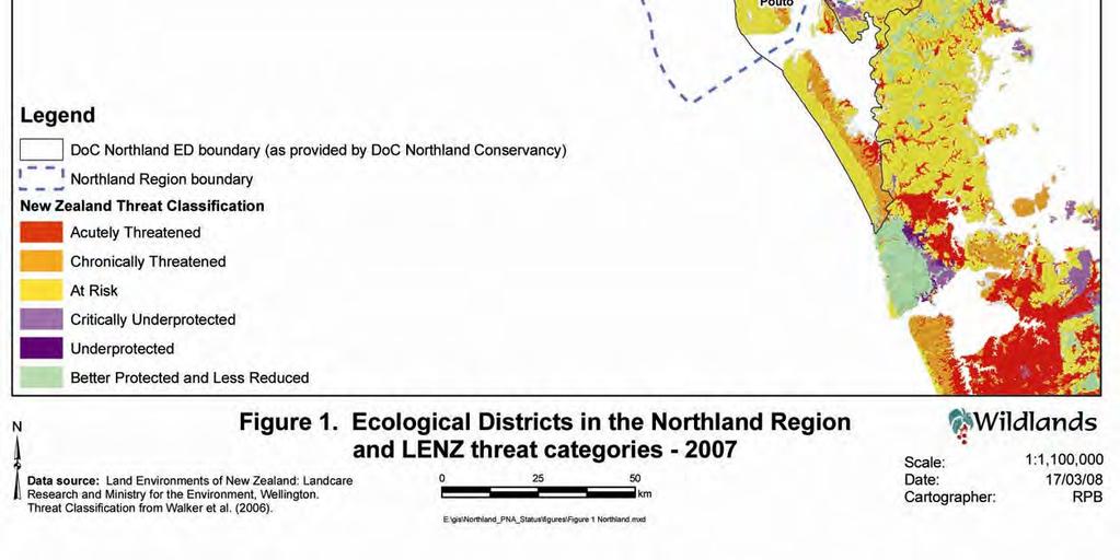
16 The Northland Regional Council area includes all or part of seven ecological regions and 24 ecological districts (Table 2). Note that the original ecological district boundaries within the Northland Region (McEwen 1987) were revised by Brook (1996) (Table 2) Proportion of Ecological Districts threatened Tables 3 and Figure 1 illustrate the size of each ecological district and the proportion that is considered to be an Acutely Threatened or Chronically Threatened land environment. About 20% (8% Acutely Threatened and 12% Chronically Threatened) of Northland falls within the first National Priority for protection (Ministry for the Environment 2007a, 2007b). The amount of area considered to be at threat varies greatly between ecological districts. For example, more than 50% of Pouto ED is considered to be highly threatened (i.e. contains significant areas of both Acutely or Chronically Threatened land environments), but only 0.8% of Te Paki comprises threatened land environments. Table 3: Total area of each ecological district in Northland and proportion that falls within Acutely or Chronically Threatened LENZ categories. Ecological districts are sorted by proportion of district threatened. (Note that the Kermadec and Mokohinau Islands are not included.) Ecolgical District Total Area (ha) Acutely Threatened Chronically Threatened Total Threatened ha % ha % % Pouto 92, , % 23, % 51.10% Whangarei 76, , % 15, % 39.00% Kaikohe 67, , % 19, % 36.30% Otamatea 57, , % 16, % 30.30% Tokatoka 74, , % 16, % 26.50% Kerikeri 67, , % 14, % 26.00% Waipu 50, , % 3, % 24.50% Rodney 20, , % 2, % 21.00% Aupouri 119, , % 14, % 20.60% Tangihua 167, , % 11, % 16.80% Manaia 6, % % 14.20% Ahipara 32, % 3, % 10.50% Maungataniwha 98, , % 2, % 10.40% Whangaruru 120, , % 10, % 10.00% Hokianga 88, , % 2, % 8.80% Tutamoe 81, , % 1, % 4.50% Whangaroa 31, % % 3.50% Puketi 24, % % 0.90% Te Paki 31, % % 0.80% Poor Knights % % 0.50% Taranga % % 0.20% Three Kings % 0.00% 0.00% Grand Total 1,311, , % 157, % 20.25% 9
17 The National Priorities for Protection (described in Section 5.1 and Ministry for the Environment 2007a, 2007b) encourage the protection of remaining indigenous vegetation in the Acutely Threatened and Chronically Threatened LENZ categories. The extent of remaining indigenous vegetation and the relationship with the Acutely Threatened and Chronically Threatened LENZ categories is illustrated in Figure PROTECTED NATURAL AREAS This section describes the number and extent of PNAs protected by various mechanisms and whether the PNA network protects areas that are thought to be ecologically significant (such as NAES). By necessity, this section includes some analysis and discussion of non-pnas to provide context and in order to appreciate the discinction between PNAs and non-pnas. 6.1 DOC administered lands, QEII covenants, and Nga Whenua Rahui These PNAs include lands administered by the the Department of Conservation on behalf of the Central Government (also known as public lands), and privately owned lands covenanted by the owners with the Queen Elizabeth II National Trust (here after QEII), or under Nga Whenua Rahui. In general, DOC administered lands and protected private lands (QEII and Nga Whenua Rahui) are mutually exclusive, but in some cases the mapped areas overlap. For example, Pakanae Scenic Reserve (overlap ha) and Motatau Scenic Reserve (overlap 97.2 ha) appear to have significant overlap with Nga Whenua Rahui mapped areas. Other overlaps are less substantial (next largest overlap is 0.5 ha), but further work may need to be undertaken to determine the exact cause of the apparent overlap. Determining the cause of overlap is beyond the scope of this project. The name of each of the areas of public conservation land that overlap with other agencies or groups is provided in Appendix 7. For the purposes of this report, overlaps between different agencies have been ignored; this may contribute to a slight error in reporting of the total areas. Note that, in general, the data used in the analysis does not include Regional Council or District Council reserves or administered land. These data were not requested, or not available, and this is an omission that needs to be rectified in subsequent analysis. In a few cases a district council or community group may be the administrating authority for an area of public lands e.g. Nihonui Scenic Reserve is public land administered by the Far North District Council and Whangarei District administers Parakao Domain, Mangapai Domain, Waiotira Domain, and Springfield Domain Recreation Reserves. These few areas have been included in the analysis. Within the analysed data, there are also a few examples of public land administered by non-government organisations such as the New Zealand Historic Places Trust or community groups. The New Zealand Historic Places Trust has principle responsibility for the Edmonds Ruins Historic Reserve and Kaipara North Head Lighthouse Historic Reserve. Community groups look after the Hukatere Hall Recreation Reserve, Kohukohu Historic Reserve, Mangonui Court House Historic 10

18 11
19 Reserve, Maungakaramea Domain Recreation Reserve, and Kerikeri Local Purpose (Pre-School) Reserve. In total, 13.75% of Northland Region s terrestrial area has some sort of legal protection (Table 4c). This equates to 2,067 areas covering 180,336.2 ha. Of that total, 1,905 areas (c.87% of the total number) covering 156,451 hectares (c.92% of the total area) are protected with the aim of conserving natural values (Table 4a). The remainder of the areas may protect natural values as a by-product of protection but that is not the purpose of the reserve or protected area (Table 4b). So the total amount of PNAs comprises c.11% of the total Northland Region area. The agency with both the greatest number of PNAs and largest area is the Department of Conservation: 144,089 ha in 802 sites, which amounts to 92% of the area covered by PNAs and 42% of the total number of sites. The Queen Elizabeth II National Trust protects the next largest share of land (6,587 ha, 4.2% of the area covered by PNAs and 475, or 25%, of the sites), followed by Nga Whenua Rahui (3,718 ha, 2.2% of the area covered by PNAs and 15, or 0.8%, of the sites). The Whangarei District Council has protected a large number of sites (613, or 32% of the total number of PNAs) but these areas comprise a relatively small total area (2,266 ha, or 1.5% of the area covered by PNAs). One-hundred and thirty one Whangarei District Council covenants are also covenanted under QEII. 6.2 Level of protection afforded by various acts Different Acts, and the various sections within each Act, afford different levels of protection for natural values. Some Acts, or sections, have a primary purpose to protect natural features within a PNA. This includes all the reserves under the Conservation Act 1, Nga Whenua Rahui Kawenata 2, Government Purpose (Wildlife) Reserve under the Reserves Act 3, and Nature Reserves under the Reserves Act 4 (Table 4a). This group comprises 620 areas (33% of the total number of PNAs) and 117,937.9 ha (75% of the total area covered by PNAs). There are four categories of legal protection where the natural features will be protected and the primary aim is usually the protection of these natural features, although there may also be other reasons for protection (e.g. landscape protection, scientific study, geomorphology). These categories are; Conservation Covenant under the Reserves Act 5, Protected Private Land under the Reserves Act 6, Scientific Reserve under the Reserves Act 7, and QEII covenants 8 (Table 4a). This group comprises 1,094 areas (57% of the total number of PNAs) and 10,832.0 ha (7% of the total area covered by PNAs) Conservation Act Nga Whenua Rahui Kawenata are legislated under 77A of the Reserves Act 1977 or Agreement for the Mangagement of Land persuant to 29 of the Conservation Act Wildlife Management Reserve as a Government Purpose Reserve, 21 of the Reserves Act 1977 and/or Wildlife Management Reserve, 14A, Wildlife Act Also includes Wildlife Refuge as a Government Purpose Reserve, 21 of the Reserves Act 1977 and/or as a Wildlife Refuge, 14 of the Wildlife Act Nature Reserve under 20 of the Reserves Act Whangarei District Council covenants are legislated under 77 of the Reserves Act Protected Private Land is legislated under 76 of the Reserves Act Scientific Reserve, 21 of the Reserves Act QEII Covenant, Queen Elizabeth II National Trust Act
20 Two further types of reserves can specify that the main focus is to protect natural features, but this is not always the primary focus of the reserve, and hence they are not always PNA. These categories are; Local Purpose Reserve under the Reserves Act 1 and Scenic Reserve under the Reserves Act. In the Northland Region, the focus of the majority of Local Purpose Reserves appears to be something other than protection of natural values (e.g. esplanade or landing reserves, building sites, and quarries), hence they are not included as PNAs (Table 4b). Scenic Reserves usually have been set up with the aim of protecting natural values and therefore they are included as PNAs (Table 4a). There are 191 Scenic Reserves (10% of the total number of PNAs) that cover 27,681.5 ha (17% of the total area covered by PNAs). There are six categories of protected land where the primary focus within the legislation is not to protect natural features (Table 4b). However, natural features can often be protected provided protection does not impinge on the primary reason for protection. These categories are; Historic Reserve under the Reserves Act 2, Recreation Reserve under the Reserves Act 3, Government Purpose Reserve under the Reserves Act (other than wildlife reserves) 4, Waitangi Endowment Act Forest under the Waitangi Endowment Act 5, and Foreshore and Seabed under the Foreshore and Seabed Act 6. A total of 162 areas and a total of 23,884.7 ha falls under this category (Table 4b). They are not considered to be PNAs Local Purpose Reserve, 22 of the Reserves Act 1977 also includes esplanade and stream reserves. Historic Reserve, 18 of the Reserves Act 1977, but also Historical Areas legislated under Stewardship Land, 7 of the Conservation Act 1987 Recreation Reserve under Reserves Act 1977 Government Purpose Reserve, 21, Reserves Act 1977 Waitangi Endowment Act Forest, 2, Waitangi Endowment Act 1932 Foreshore and Seabed Act (3) 13

21 14

22 15
23 16

24 17

25 18
26 19

27 20


28 21

29 22

30 23

31 24
32 Table 4a: Area and number (in brackets) of Protected Natural Areas in Northland Region. Data provided 15 April Reserve Type and Act Public Conservation Land # Administrative Authority Whangarei District QEII Nga Whenua Rahui Total % of Total Area in Northland Conservation Park under Conservation Act 78,631.9 (20) 78,631.9 (20) 6.00% Marginal Strip under Conservation Act 2,260.4 (348) 2,260.4 (348) 0.17% Sanctuary Area under Conservation Act 4.7 (1) 4.7 (1) 0.00% Stewardship Land under Conservation Act 29,780.1 (209) 29,780.1 (209) 2.27% Government Purpose (Wildlife) Reserve under Reserves Act 1,934.2 (20) 1,934.2 (20) 0.15% Nature Reserve under Reserves Act 1,818.1 (7) 1,818.1 (7) 0.14% Protected Private Land under Reserves Act 3.7 (1) 3.7 (1) 0.00% Scientific Reserve under Reserves Act 1,975.1 (5) 1,975.1 (5) 0.15% Scenic Reserve under Reserves Act 27,681.5 (191) (O) (2) 27,681.5 (191) 2.11% WDC covenant 2,266.0 (613) (O) (131) 2,266.0 (613) 0.17% NWR 3,508.5 (15) 3,508.5 (15) 0.27% QEII (O) (131) 6,587.2 (475) 6,587.2 (475) 0.50% Total 144,089.8 (802) 2,266.0 (613)) 6,587.2 (475) 3,718.0ha (15) 156,451.5 (1905) 11.93% % of total area covered by PNAs in Northland 92.10% 1.45% 4.21% 2.24% % of total number of PNAs in Northland 42.10% 32.18% 24.93% 0.79% % of total area in Northland 10.99% 0.17% 0.50% 0.27% # Public conservation land is predominantly administered by the Department of Conservation but there are a number of reserves administed by local councils; (O) Overlap in responsibilities. 25
33 Table 4b: Area and number (in brackets) of protected areas in Northland Region for which legislative mandate is not protection of natural values. Data provided 15 April Reserve Type and Act Administrative Authority Public Conservation Land Foreshore and Seabed under Foreshore and Seabed Act 2,446.7 (44) Government Purpose Reserve under Reserves Act 6.3 (5) Historic Reserve under Reserves Act (24) Local Purpose Reserve under Reserves Act 30.6 (29) Recreation Reserve under Reserves Act 20,418.9 (59) Waitangi Endowment Act Forest under Waitangi Endowment Act (1) Total 23,884.7 (162) % of total area in Northland 1.82% Table 4c: Area and number (in brackets) of DOC managed lands, QEII covenant or Nga Whenua Rahui land in Northland Region for which legislative mandate is protection of natural values. Data provided 15 April Administrative Authority Total Reserve Type Public Whangarei Nga Whenua QEII Conservation Land District Rahui Protected Natural Areas 144,089.8 (802) 2,266.0 (613) 6,587.2 (475) 3,508.5 (15) 156,451.5 (1,905) Other reserves 23,884.7 (162) 23,884.7 (162) Total 167,974.5 (964) 2,266.0 (613) 6,587.2 (475) 3,508.5 (15) 180,336.2 (2067) % of total reserve area that is PNA 85.78% 86.76% % of total number of reserves that are PNAs 84.20% 92.16% % of Northland that is PNA 11.93% % of Northland that is reserve 13.75% 26
34 6.3 Protection status of Natural Areas of Ecological Significance (NAES) Nineteen of Northland Region s 24 ecological districts have been surveyed or partially surveyed 1 as part of the protected natural areas programme (PNAP). The PNAP surveys identified 1320 Natural Areas of Ecological Significance (NAES), with a combined area of 283,947.8 ha (Table 5). In total, 506 NAES (37.39% of the total number) are partially or fully protected by some mechanism. Of these, 444 NAES (equalling 85,535.9 ha or 31.5% of the area) are currently partially or fully protected by one or sometimes multiple protection mechanisms that protect natural values (i.e. mechanism that result in PNAs). A further 162 NAES (equalling 16,636 ha or 5.86% of the area) are partially or fully protected by a mechanism that may not protect natural values. Table 5: Protection status of Natural Areas of Ecological Significance (NAES) in Northland Region. Data provided 7 December Protection Mechanism Area (ha) Number % Total Area % Total Number Protected Natural Areas Conservation Park under Conservation Act 45, % 1.97% Marginal Strip under Conservation Act % 9.70% Sanctuary Area under Conservation Act % 0.08% Stewardship Land under Conservation Act 19, % 9.32% Government Purpose (Wildlife) Reserve under Reserves Act 1, % 1.36% Nature Reserve under Reserves Act % 0.15% Protected Private Land under Reserves Act % 0.08% Scientific Reserve under Reserves Act % 0.23% Scenic Reserve under Reserves Act 14, % 10.61% Nga Whenua Rahui Kawenata 2, % 0.83% QEII covenant 4, % 13.86% Whangarei District Council Covenant % 8.79% Total Protected Natural Areas 1 89, % 33.64% Other Protected Areas (non-pnas) Foreshore and Seabed under Foreshore and Seabed Act 2, % 1.36% Government Purpose Reserve under Reserves Act % 0.23% Historic Reserve under Reserves Act % 0.91% Local Purpose Reserve under Reserves Act % 0.45% Recreation Reserve under Reserves Act 2, % 3.03% Waitangi Endowment Act Forest under Waitangi Endowment Act % 0.15% Approved Community Pest Control Areas 1, % 4.24% Fish and Game Wetlands % 0.23% Landcare Group 11, % 8.94% Total non-pna 1 16, % 12.27% Total NAES partially or totally protected 106, % 38.33% Total NAES 283, NAES not completely protected 177, % 97.88% NAES not protected at all 39, % 61.67% 1 The total area and total number of NAES protected will not sum to this total because some NAES are protected by more than one mechanism. 1 Note that the five ecological districts that have not been surveyed are all offshore island groups. 27
35 Sixty-two percent of NAES are not protected or managed by any mechanism. Of those that are protected or looked after (this includes legal protection but also efforts by community groups) nearly all NAES (98%) only have part of their total area protected. The NAES which are completely without protection or not being looked after by community groups are listed in Appendix 8. A NAES can have one or more protection mechanism and these mechanisms can sometimes be applied over the same topographic area (e.g. a scenic reserve that is also looked after by Fish and Game and a Landcare Group) (Table 6). Of the PNAs, 15.9% (by area) is protected by Conservation Parks under the Conservation Act. A further 7% is protected as Stewardship Land under Conservation Act, Scenic Reserves under Reserves Act protects 5%, QEII Trust looks after 1.4% and the remainder sums to less than 1%. Numerically, 31.5% of protected NAES are partially or fully protected by mechanisms whose primary purpose is conservation of natural resources, flora and or fauna. The largest categories are QEII covenant (13.9%), Scenic Reserve under Reserves Act (10.6%), Stewardship Land under Conservation Act (9.3%) and Whangarei District Council Covenants (8.8%). Table 6: Number of protection mechanisms per Natural Area of Ecological Significance (NAES). Data provided 7 December Number of Mechanisms Number of NAES Percent number of NAES Whangarei District Council Covenants Whangarei District Council has required the covenanting of 613 areas, totalling 2,266.0 ha (Table 7). Nearly 50% of them (24% by area) were not Natural Areas of Ecological Significance (NAES) identified in PNAP surveys. In total, 311 NAES are fully or partially protected by WDC covenants. Comparing the number of WDC covenants and the number of NAES protected is not straightforward, since some WDC covenants have multiple protection mechanisms and are sometimes superseded by other mechanisms (e.g. QEII covenant and a WDC covenant relating to the same area). Similarly, some NAES have more that one 28
36 mechanism or type of covenant (e.g. two QEII covenants and two WDC covenants cover Kokopu Block Road Bush) or part of the NAES is protected and part isn t. Table 7 provides an overview of the area and number of WDC covenants that include NAES. Approximately half of the WDC covenants include both NAES and areas that are not NAES, and on average the proportion of a WDC covenant that is NAES is 66% ± 4% (95% confidence interval), but this ranges from 1% to 99% NAES. Furthermore, sliver polygons, where the GIS layers don t quite line up when overlaid, may be artificially affecting the overall numbers. Where possible these slivers of overlap have been removed, but it is not possible to remove all slivers by just looking at the tabulated (not mapped) data. Table 7: Area and number of Whangarei District Council (WDC) covenants that are Natural Areas of Ecological Significance (NAES). QEII: Queen Elizabeth II covenants; CPCA: Community Pest Control Area; F&G: NZ Fish and Game wetlands. Data provided 11 January WDC WDC & QEII WDC & CPCA WDC & F&G Grand Total Area in ha Not NAES , % NAES , % Total 1, ,266.0 % of total ha that is NAES 78.0% 20.4% 1.5% 0.1% Numbers Not NAES % NAES % Total 613 % Area Numbers % Total ha % Total Number Not NAES % 49.3% NAES % 4.2% Both 1, % 46.5% Total 2, OTHER PROTECTION MECHANISMS (NON-PNAS) 7.1 Kaipara District Council Biodiversity Improvement Fund The aim of the fund is to help and encourage people to restore and improve Kaipara District s natural environment. Examples of projects that may be funded include fencing and restoration of bush or wetlands, dune care, and animal and pest control. Individuals, private landowners, community groups, conservation organisations, iwi and school groups may apply (Kaipara District Council 2007). Most of the location data provided is point data, not mapped area data, and therefore no mapped extent or overlaps of area could be calculated. Only three projects had information about the geographical extent of the project and the data was received 29
37 mechanism or type of covenant (e.g. two QEII covenants and two WDC covenants cover Kokopu Block Road Bush) or part of the NAES is protected and part isn t. Table 7 provides an overview of the area and number of WDC covenants that include NAES. Approximately half of the WDC covenants include both NAES and areas that are not NAES, and on average the proportion of a WDC covenant that is NAES is 66% ± 4% (95% confidence interval), but this ranges from 1% to 99% NAES. Furthermore, sliver polygons, where the GIS layers don t quite line up when overlaid, may be artificially affecting the overall numbers. Where possible these slivers of overlap have been removed, but it is not possible to remove all slivers by just looking at the tabulated (not mapped) data. Table 7: Area and number of Whangarei District Council (WDC) covenants that are Natural Areas of Ecological Significance (NAES). QEII: Queen Elizabeth II covenants; CPCA: Community Pest Control Area; F&G: NZ Fish and Game wetlands. Data provided 11 January WDC WDC & QEII WDC & CPCA WDC & F&G Grand Total Area in ha Not NAES , % NAES , % Total 1, ,266.0 % of total ha that is NAES 78.0% 20.4% 1.5% 0.1% Numbers Not NAES % NAES % Total 613 % Area Numbers % Total ha % Total Number Not NAES % 49.3% NAES % 4.2% Both 1, % 46.5% Total 2, OTHER PROTECTION MECHANISMS (NON-PNAS) 7.1 Kaipara District Council Biodiversity Improvement Fund The aim of the fund is to help and encourage people to restore and improve Kaipara District s natural environment. Examples of projects that may be funded include fencing and restoration of bush or wetlands, dune care, and animal and pest control. Individuals, private landowners, community groups, conservation organisations, iwi and school groups may apply (Kaipara District Council 2007). Most of the location data provided is point data, not mapped area data, and therefore no mapped extent or overlaps of area could be calculated. Only three projects had information about the geographical extent of the project and the data was received 29
38 long after all other data had been analysed. A summary of Kaipara District Council Biodiversity Improvement Fund Projects are provided in Table 8. Table 8: Applicant Kaipara District Council Biodiversity Improvement Fund Projects. Data provided 27 February Aim of Project Habitat and Ecological District LENZ Threat Category Area (ha) Hua Raukau Trust Dune care Coastal Sand and At Risk Gravel, Pouto ED Glinks Gully Dune care/planting Flaxland, Pouto ED At Risk Coastcare Friends of Mangawhai Harbour Riparian management Mangawhai Harbour Restoration Mangawhai Pride Private Landowner Paparoa Lions Private landowner/ QEII covenant Private Landowner Private Landowner Northern Wairoa Flax Community Mangawhai River Enhancement Private Landowner Dune restoration/ planting Riparian/estuary protection Bush restoration and fencing Predator control Possum control Bush restoration and fencing Bush protection/ fencing Bush protection/ fencing Riparian Planting Bush protection/ fencing Indigenous Forest, Tokatoka Critically Underprotected Northland Regional Council Community Pest Control Areas Communities can propose to the NRC that an area should be protected from a particular plant and/or animal pest. If the Council agrees, the area becomes a Community Pest Control Area (CPCA), pests defined in the proposal become total control pests for that area, and the landholder(s) must follow a programme of control (following an initial knockdown) (Northland Regional Council 2008). There are 14 Approved CPCAs in the Northland Region. Another nine have been proposed. They range in size from approximately 9 ha to nearly 6,500 ha (Table 9). Nine CPCAs were included in the analysis (they had mapped areas). Nearly all are on private land (98.5% of total area), with a further 1.1% (92.8 ha) on Public Conservation Land, 0.4% (33.1 ha) within Whangarei District Council covenants, and 4.4 ha of QEII covenant included in one project. Northland Regional Council currently contributes to protecting biodiversity values on nearly 12,000 ha of private land. This area will roughly double when the pending projects are included. 30
39 Table 9: Approved Community Pest Control Areas and NAES. Data provided 31 January Approved Community Pest Control Areas Area (ha) Number and area of NAES Skudders Beach (0.2 ha) Mangaiti Bay (0.4 ha) Manganese Point (6.4 ha) Petley Road (17.2 ha) Maungaraho Rock Waiare Valley, Kaeo (426.2 ha) Linton road (169.0 ha) Te Kuri 1, Oneriri 3, (650.1 ha) Subtotal 7, (1,269.5 ha)* Additional CPCA received after analysis Nook 121 approved Tutukaka 231 approved Takahoa Bay 226 approved Purerua Peninsula 3,212 approved Opara Estuary 158 approved Subtotal 3,948 Pending CPCA received after analysis Ranganui 921 pending Hoanga 1,690 pending Swan Lake 664 pending Mangaru 6,438 pending Marohemo 992 pending Pataua North 789 pending Waione 137 pending Dargaville wetland 55 pending Rawhiti 61 pending Total approved 11,902 Total pending 11,747 Total 23,649 * Two CPCAs protect part of the Arapaoa River NAES, Linton Road, and Petley Road. Nearly all the projects included in the analysis contained one or more (whole or part) Natural Area of Ecological Significance (NAES). Nearly fifteen percent of the area under CPCA projects is also NAES (Table 10). Fourteen percent of private land included in the CPCAs is NAES and 77% of Public Conservation Land is also NAES. Table 10: Area of Community Pest Control Areas (CPCAs) that are NAES. Data provided 31 January Administration Area (ha) % NAES Not NAES NAES Total Private land 7, , , % DOC managed land % QEII % WDC covenant % Total 7, , , % 31
40 7.3 Northland Regional Council CoastCare Groups Northland Regional Council, through its Environment Fund, also supports a number of CoastCare Groups. The Northland Regional Council Environment Fund has provided over $1.5 million to help people improve and protect Northland s natural environment since In 2007 the contestable fund increased from $450,000 to around $500,000. The Regional Council recognises the effort and commitment that Northlanders are putting into improving native biodiversity and the increase in funding reflects this. The fund is targeted at several different areas with most projects funded at 50% of their total costs (Northland Regional Council 2007). Projects must be of long-term benefit to the local environment and show evidence of good resource management. Examples of projects funded previously include protecting native bush and wetlands by fencing out stock, replanting streamsides, dune management, and pest control to enhance native habitat (Northland Regional Council 2007). Laura Shaft is the CoastCare Co-ordinator for the Northland Regional Council and provided the list (Table 11) and map (Figure 4) of Current coast Care Groups. From the names of the Coast Care Groups it would appear that there is some overlap with the Northland Region Community Pest Control Areas, but due to the late acquisition of this information and the lack of a GIS data (mapping) layer it is not possible to provide any further analysis. Table 11: List of Northland Region Coast Care Groups. Data provided 10 April Coast Care Group Baylys Beach Society Inc Bream Bay Coastal Care Trust Doubtless Bay Marine Protection Group Glinks Gully Protection Society Inc Hokianga Harbour Foreshore Restoration Society Inc (HHFRS) Hua Rakau Ki Omamari Trust Kaimaumau Coastal Reserve Group Karikari Peninsula Beach Care Group Mangawhai Heads Restoration Society Ocean Beach Protection Group Owhata Ahu Whenua Trust Taipa Beach Improvement Society Taupo Bay Progressive Association Inc Tauranga Bay Community Association Te Ngare Bay CoastCare Group Te Roopu Whakaoranga O Te Taha Moana Waipapakauri Coastal Care Group Whananaki CoastCare Group 32

41 Figure 4: Map of Coast Care Groups in Northland Region. (Image provided by Laura Shaft, Northland Regional Council) 7.4 Fish and Game wetlands New Zealand Fish and Game looks after five wetland areas in Northland. These range in size from 22.5 ha to 56.5 ha. Three include part of a single NAES; Jack Bisset Wetlands includes 25.8 of Draffin Farm Wetland; Kawakawa Wetlands includes 17.0 ha of Kawakawa Flood plain; and Waitangi Wetlands includes 3.6 ha of Waitangi Wetlands and Environs. By area, 67% of the Fish and Game administered land is private land or land owned by Fish and Game. A further 31.6% is Public Conservation Land and a very small percentage is a QEII covenant or a Whangarei District Council covenant (Table 12). 33
Conservation Partners for the National Reserve System Program: a Western NSW focus
 Conservation Partners for the National Reserve System Program: a Western NSW focus Cooper, N. 1, Webber, L. 2, Nicolson, K. 3 1 Department of Environment, Climate Change and Water NSW, PO Box 788 Broken
4) Data sources and reporting ) References at the international level... 5
 Data sources and reporting ) References at the international level... 5") D- 1: Protected areas (PA) 1) General description... 2 1.1) Brief definition... 2 1.2) Units of measurement... 2 1.3) Context...2 2) Relevance for environmental policy... 2 2.1) Purpose... 2 2.2) Issue...
D- 1: Protected areas (PA) 1) General description... 2 1.1) Brief definition... 2 1.2) Units of measurement... 2 1.3) Context...2 2) Relevance for environmental policy... 2 2.1) Purpose... 2 2.2) Issue...
Order of the Minister of Environment #39, August 22, 2011 Tbilisi
 Registration Code 360050000.22.023.016080 Order of the Minister of Environment #39, August 22, 2011 Tbilisi On preparatory stages and procedure of the methodology for Elaborating structure, content and
Park-specific management and policies Wainuiomata Recreation Area
 Park-specific management and policies Wainuiomata Recreation Area 6.8 Wainuiomata Recreation Area 6.8.1 Legal status Title held: Legislative status: Wellington Regional Council Administered under Local
SANBI PLANNING FORUM
 SANBI PLANNING FORUM SPATIAL PLANNING IN PROTECTED AREAS AND THEIR BUFFERS (South Africa) Ms Jayshree Govender, Dr Mike Knight and Mr Russell Smart 22 June 2017 OUTLINE 1) Introduction 2) Protected areas
PROTECTED AREAS ZONE - POLICY
 PROTECTED AREAS ZONE - POLICY.1 Introduction The Protected Areas Zone applies to the land depicted on the Ruapehu District Plan Maps as: Amenity Policy Area. Protected Areas - Conservation. (c) Protected
Draft LAW. ON SOME AMENDAMENTS IN THE LAW No.9587, DATED ON THE PROTECTION OF BIODIVERSITY AS AMENDED. Draft 2. Version 1.
 Technical Assistance for Strengthening the Capacity of the Ministry of Environment, Forests and Water Administration in Albania for Law Drafting and Enforcement of National Environmental Legislation A
TOWARDS SUSTAINABLE MANAGEMENT OF MARINE AND COASTAL HABITATS ASIA- PACIFIC DAY FOR THE OCEAN
 TOWARDS SUSTAINABLE MANAGEMENT OF MARINE AND COASTAL HABITATS WANNAKIAT THUBTHIMSANG PHUKET MARINE BIOLOGICAL CENTER, DMCR, THAILAND ASIA- PACIFIC DAY FOR THE OCEAN 20 NOVEMBER 2018, CONFERENCE ROOM 4,
Marchand Provincial Park. Management Plan
 Marchand Provincial Park Management Plan 2 Marchand Provincial Park Table of Contents 1. Introduction... 3 2. Park History... 3 3. Park Attributes... 4 3.1 Natural... 4 3.2 Recreational... 4 3.3 Additional
INFORMATION NOTICE 15-2 Limited & Excluded Lands
 INFORMATION NOTICE 15-2 Limited & Excluded Lands Schedule 1 (Land Description) of onshore petroleum Agreements issued by the Department of Energy details the total hectares calculated. Total hectares are
PRIORITY HABITAT SURVEY 2017 SWALEDALE. Summary. July 2018
 PRIORITY HABITAT SURVEY 2017 SWALEDALE Summary July 2018 Conservation & Monitoring Report No: Lead Author(s): Tony Serjeant & Sue Thurley Incorporating comments from: Gary Smith & Gordon Haycock (16/07/18)
Michipicoten Island Regional Plan
 Michipicoten Island Regional Plan This is one of twenty Regional Plans that support implementation of the Lake Superior Biodiversity Conservation Strategy (Strategy). The Strategy, prepared and overseen
Protected Areas in the Arabian Peninsula
 Protected Areas in the Arabian Peninsula Khaldoun Al Omari Abstract. Protected areas help conserve key elements of biodiversity, play a significant role in social and economic development, and embody many
Analysing data on protected areas
 Analysing data on protected areas International goals The OECD is developing an improved method to generate more detailed indicators on protected areas, both terrestrial and marine, for countries across
What is an Marine Protected Area?
 Policies, Issues, and Implications of Marine Protected Areas Kara Anlauf University of Idaho Before the House Subcommittee on Fisheries Conservation, Wildlife and Oceans April 29, 2003 What is an Marine
Visual and Sensory Aspect
 Updated All Wales LANDMAP Statistics 2017 Visual and Sensory Aspect Final Report for Natural Resources Wales February 2018 Tel: 029 2043 7841 Email: sw@whiteconsultants.co.uk Web: www.whiteconsultants.co.uk
Appendix F Public authorities responses
 Planning Proposal under sec 55 of the EP&A Act LEP Refinements Appendix F Public authorities responses Appendix F Public authorities responses Prior to public exhibition, consultation was made with the
SOUTHLAND CONSERVATION BOARD
 SOUTHLAND CONSERVATION BOARD TE ROOPU ATAWHAI O MURIHIKU Secretariat Local Government and Environment Committee Select Committee Office Parliament Buildings WELLINGTON 6011 To the Local Government and
1.4 Previous research on New Zealand subantarctic tourism
 Figure 5 The subantarctic islands are nature reserves protecting habitats of great conservation value, such as that of the Southern Royal albatross, seen here at the Auckland Islands. Tourist visits must
Biosphere Reserves of India : Complete Study Notes
 Biosphere Reserves of India : Complete Study Notes Author : Oliveboard Date : April 7, 2017 Biosphere reserves of India form an important topic for the UPSC CSE preparation. This blog post covers all important
Whitemouth Falls Provincial Park. Draft Management Plan
 Whitemouth Falls Provincial Park Draft Management Plan Whitemouth Falls Provincial Park Draft Management Plan Table of Contents 1. Introduction... 3 2. Park History... 3 3. Park Attributes... 4 3.1 Natural...
Accommodation Survey: November 2009
 Embargoed until 10:45am 19 January 2010 Accommodation Survey: November 2009 Highlights Compared with November 2008: International guest nights were up 2 percent, while domestic guest nights were down 1
Labrador - Island Transmission Link Target Rare Plant Survey Locations
 27-28- Figure: 36 of 55 29-28- Figure: 37 of 55 29- Figure: 38 of 55 #* Figure: 39 of 55 30- - east side Figure: 40 of 55 31- Figure: 41 of 55 31- Figure: 42 of 55 32- - secondary Figure: 43 of 55 32-
The Roots of Carrying Capacity
 1 Applying Carrying Capacity Concepts in Wilderness 1872 1964...shall be preserved for the use & enjoyment of the American people...in such manner as will leave them unimpaired for future generations...
ECORREGIONAL ASSESSMENT: EASTERN CORDILLERA REAL ORIENTAL PARAMOS AND MONTANE FORESTS
 ECORREGIONAL ASSESSMENT: EASTERN CORDILLERA REAL ORIENTAL PARAMOS AND MONTANE FORESTS The Nature Conservancy, EcoCiencia y Fundación AGUA. 2005. Evaluación Ecorregional de los Páramos y Bosques Montanos
Applying Carrying Capacity Concepts in Wilderness
 Applying Carrying Capacity Concepts in Wilderness...shall be preserved for the use & enjoyment of the American people...in such manner as will leave them unimpaired for future generations... CSS 490 Professor
BLAIRGOWRIE COMMON GOOD FUND COMMITTEE. 1 May 2013 QUEEN ELIZABETH II FIELDS 2012 CHALLENGE IN PERTH AND KINROSS
 BLAIRGOWRIE COMMON GOOD FUND COMMITTEE 4 13/205 1 May 2013 QUEEN ELIZABETH II FIELDS 2012 CHALLENGE IN PERTH AND KINROSS Report by Depute Director (Environment) PURPOSE OF REPORT This report seeks the
Global Sustainable Tourism Destinations Criteria
 Global Sustainable Tourism Destinations Criteria Draft destination level Global Sustainable Tourism Criteria as proposed after Destinations and International Standards joint working group meeting and follow-up
1 INFORMATION REQUIREMENTS
 1 INFORMATION REQUIREMENTS 1.1 BACKGROUND 2 1.2 WHAT IS THE DISTRICT PLAN 3 1.3 DISTRICT PLAN STRUCTURE 4 1.4 HOW TO USE THE DISTRICT PLAN 5 1.5 STRATEGIC FRAMEWORK 6 Whanganui District Plan (15 January
Hauraki Maori Trust Board STRATEGIC PLAN
 Hauraki Maori Trust Board STRATEGIC PLAN FOR THE CUSTOMARY FISHERIES OF HAURAKI 2002-2052 1 This strategic planning document was developed for and approved by the Hauraki Maori Trust Board on 12 February
Instream intrinsic values of the Te Puna Creek catchment
 Instream intrinsic values of the Te Puna Creek catchment J. Benn Technical Support Department of Conservation Canterbury Conservancy Christchurch (25 October 2011) Draft/living document Disclaimer This
RE: Access Fund Comments on Yosemite National Park Wilderness Stewardship Plan, Preliminary Ideas and Concepts
 September 30, 2016 Superintendent Yosemite National Park Attn: Wilderness Stewardship Plan P.O. Box 577 Yosemite, CA 95389 RE: Access Fund Comments on Yosemite National Park Wilderness Stewardship Plan,
Establishing a National Urban Park in the Rouge Valley
 STAFF REPORT ACTION REQUIRED Establishing a National Urban Park in the Rouge Valley Date: March 29, 2012 To: From: Wards: Reference Number: Executive Committee Deputy City Manager, Cluster B All p:\2012\cluster
Twelve Apostles Marine National Park Australia
 EVALUATION REPORT Twelve Apostles Marine National Park Australia Location: Victoria, Australia coastal waters Global Ocean Refuge Status: Nominated (2017), Evaluated (2017) MPAtlas.org ID: 7703885 Manager(s):
Coastal Peak Population Survey
 Coastal Peak Population Survey Final Report 2012-2013 September 2014 Executive Summary The Whangarei District Council conducted a survey to determine peak populations of coastal areas between the 21 December
Land Management Summary
 photo credit: ANGAIR Anglesea Heath Land Management Summary The Anglesea Heath (6,501 ha) was incorporated into the Great Otway National Park in January 2018. This provides an opportunity to consider the
How South Africa is making progress towards the Aichi 2020 Target 11
 How South Africa is making progress towards the Aichi 2020 Target 11 Montreal, Canada 2 May 2016 Oceans and Coasts Content Protected area considerations and progress 1994-2010 Terrestrial Protected Area
Overview. Wilderness Act of Statement of Need. What is Wilderness Character. Monitoring Wilderness Character
 Overview Monitoring Wilderness Character What What & Why? How? How? Conceptual Development How? How? Implementation Future? Future? Troy Hall Steve Boutcher USFS Wilderness & Wild and Scenic River Program
UNITED STATES DEPARTMENT OF THE INTERIOR BUREAU OF LAND MANAGEMENT MANUAL TRANSMITTAL SHEET
 Form 1221-2 (June 1969) UNITED STATES DEPARTMENT OF THE INTERIOR BUREAU OF LAND MANAGEMENT MANUAL TRANSMITTAL SHEET Release 8-83 Date Subject 8353 Trail Management Areas Secretarially Designated (Public)
Numaykoos Lake Provincial Park. Management Plan
 Numaykoos Lake Provincial Park Management Plan 2 Numaykoos Lake Provincial Park Table of Contents 1. Introduction... 3 2. Background... 3 3. Park Purpose... 5 4. Park Management Guidelines... 6 Appendix...
Planning & Building Department
 Page 1 of Report Planning & Building Department To: Subject: Community Development Committee Protecting Escarpment Rural Land (PERL) Proposed Niagara Escarpment Plan Amendment Niagara Escarpment Commission
Birch Point Provincial Park. Management Plan
 Birch Point Provincial Park Management Plan 2 Birch Point Provincial Park Table of Contents 1. Introduction... 3 2. Park History... 3 3. Park Attributes... 4 3.1 Natural... 4 3.2 Recreational... 4 4. Park
Terrestrial Protected Area Nomination: Central Mangrove Wetland South-West, Grand Cayman
 Terrestrial Protected Area Nomination: Central Mangrove Wetland South-West, Grand Cayman The attached nomination, proposing that a parcel of land in the Central Mangrove Wetland be made a Protected Area
Te Manahuna Consulting
 Assessment of the natural values at the proposed centre pivot irrigation site and surrounds on Ben Ohau Station, Mackenzie Basin, New Zealand August 2016 Abstract The natural values of the area proposed
Continental Divide National Scenic Trail Legislative History and Planning Guidance
 Continental Divide National Scenic Trail Legislative History and Planning Guidance Legislation, Policy, and Direction Regarding National Scenic Trails The National Trails System Act, P.L. 90-543, was passed
Mackinnon Esker Ecological Reserve Draft - Management Plan
 Mackinnon Esker Ecological Reserve Draft - Management Plan May 2011 Photo Credit: This document replaces the direction provided in the Carp Lake Provincial Park and Protected Area and Mackinnon Esker Ecological
We, Ministers, assembled in Berlin for the International Conference on Biodiversity and Tourism from 6 to 8 March 1997
 March 8th, 1997 Berlin Declaration BIOLOGICAL DIVERSITY AND SUSTAINABLE TOURISM We, Ministers, assembled in Berlin for the International Conference on Biodiversity and Tourism from 6 to 8 March 1997 -
Federal Land and Resource Management: A Primer 1
 Federal Land and Resource Management: A Primer 1 RS20002 Coordinated by Ross W. Gorte Natural Resource Economist and Policy Specialist Environment and Natural Resources Policy Division December 22, 1998
FILE: /PERM EFFECTIVE DATE: May 16, 2014 AMENDMENT:
 APPROVED AMENDMENTS: Effective Date Briefing Note /Approval Summary of Changes: FILE: 11000-00/PERM EFFECTIVE DATE: May 16, 2014 AMENDMENT: Table of Contents 1. POLICY APPLICATION... 1 2. PRINCIPLES AND
Wilderness Stewardship Plan Scoping Newsletter Winter 2013
 Olympic National Park National Park Service U.S. Department of the Interior Wilderness Stewardship Plan Scoping Newsletter Winter 2013 Dear Friends and Neighbors, The Olympic Wilderness was established
Alternative 3 Prohibit Road Construction, Reconstruction, and Timber Harvest Except for Stewardship Purposes B Within Inventoried Roadless Areas
 Roadless Area Conservation FEIS Summary Table S-1. Comparison of Key Characteristics and Effects by Prohibition Alternative. The effects summarized in this table A would occur in inventoried roadless areas
MANAGEMENT DIRECTION STATEMENT June, 1999
 Thompson River District MANAGEMENT DIRECTION STATEMENT June, 1999 for Roche Lake Provincial Park Ministry of Environment Lands and Parks BC Parks Division Table of Contents I. Introduction A. Setting
Biodiversity and Protected Areas-- Ukraine
 Biodiversity and Protected Areas-- Ukraine EarthTrends Country Profiles Ukraine Europe World Total Land Area (000 ha) 60,370 2,301,873 13,328,979 Protected Areas Extent of Protected Areas by IUCN Category
BABIA GÓRA DECLARATION ON SUSTAINABLE TOURISM DEVELOPMENT IN MOUNTAIN AREAS
 BABIA GÓRA DECLARATION ON SUSTAINABLE TOURISM DEVELOPMENT IN MOUNTAIN AREAS The participants of the International Workshop for CEE Countries Tourism in Mountain Areas and the Convention on Biological Diversity",
Minimum Requirements References in National Park Service Policy
 Minimum Requirements References in National Park Service Policy 2006 NPS Management Policies Chapter 6: Wilderness Preservation and Management 6.3 Wilderness Resource Management 6.3.1 General Policy (in
Potential additions to Aoraki/Mount Cook National Park and the World Heritage Area
 Topic Paper: Potential additions to Aoraki/Mount Cook National Park and the World Heritage Area. Purpose This paper provides the relevant background and matters for consideration regarding potential additions
International Union for Conservation of Nature and Natural Resources
 - 156 - APPENDIX XIX International Union for Conservation of Nature and Natural Resources 1110 Morges, Switzerland RESOLUTIONS ADOPTED BY THE TENTH GENERAL ASSEMBLY OF IUCN New Delhi, India, 1 December
The KwaZulu-Natal 2012 Critical Biodiversity Areas Map. Boyd Escott GIS Analyst (Terrestrial) Ezemvelo KZN Wildlife
 Ezemvelo KZN Wildlife") The KwaZulu-Natal 2012 Critical Biodiversity Areas Map Boyd Escott GIS Analyst (Terrestrial) Ezemvelo KZN Wildlife KZN Systematic Conservation Plan (i) Marine, (ii) Estuarine (iii) Freshwater, and (iv)
The KwaZulu-Natal 2012 Critical Biodiversity Areas Map Boyd Escott GIS Analyst (Terrestrial) Ezemvelo KZN Wildlife KZN Systematic Conservation Plan (i) Marine, (ii) Estuarine (iii) Freshwater, and (iv)
Pinawa Provincial Park. Draft Management Plan
 Pinawa Provincial Park Draft Management Plan Pinawa Provincial Park Draft Management Plan Table of Contents 1. Introduction... 3 2. Park History... 3 3. Park Attributes... 4 3.1 Natural... 4 3.2 Recreational...
Spatial Distribution and Characteristics of At-Risk Species in the Southeast U.S.
 Nicholas Institute for Environmental Policy Solutions Scoping Document Part 2 Exploratory Analysis of Characteristics and Trends of At-Risk Species in the Southeast U.S. Spatial Distribution and Characteristics
The area involved 17th annual report
 The area involved 17th annual report MARINE AGGREGATE EXTRACTION 2014 Contents 01: Introduction Summary information 02-03: Summary statistics for 2014 04-05: Humber region 06-07: East Coast region 08-09:
Protection of Ulcinj Saline
 Strasbourg, 25 March 2015 T-PVS/Files (2015) 21 [files21e_2015.docx] CONVENTION ON THE CONSERVATION OF EUROPEAN WILDLIFE AND NATURAL HABITATS Standing Committee 35 th meeting Strasbourg, 1-4 December 2015
Wallace Lake Provincial Park. Management Plan
 Wallace Lake Provincial Park Management Plan 2 Wallace Lake Provincial Park Table of Contents 1. Introduction... 3 2. Park History... 3 3. Park Attributes... 4 3.1 Natural... 4 3.2 Recreational... 4 4.
Draft Resolution on wetlands in polar and subpolar regions
 RAMSAR CONVENTION ON WETLANDS 54th Meeting of the Standing Committee Gland, Switzerland, 23 27 April 2018 Submitted by Sweden Draft Resolution on wetlands in polar and subpolar regions Doc. SC54-21.14
SUBMISSION FROM BIG SCRUB LANDCARE ON THE DRAFT NSW BIODIVERSITY CONSERVATION BILL AND ACCOMPANYING LEGISLATION AND CODES
 TP Draft 23 June 2016 SUBMISSION FROM BIG SCRUB LANDCARE ON THE DRAFT NSW BIODIVERSITY CONSERVATION BILL AND ACCOMPANYING LEGISLATION AND CODES ABOUT THIS SUBMISSION 1. This submission by Big Scrub Landcare
Ouimet Canyon Provincial Nature Reserve. Management Plan
 Ouimet Canyon Provincial Nature Reserve Management Plan NOTE: This document has been scanned and formatted, and therefore is slightly different from the original version. -March 2002 Additional copies
Defining housing markets using postcode sectors
 Defining housing markets using postcode sectors 8.1 Introduction...1 8.2 The results for Jan to Mar 2006...1 Cambridge City...1 East Cambridgeshire...1 Fenland...2 Forest Heath...2 Huntingdonshire...3
Ontario s Approach to Wilderness: A Policy May 1997 (Version 1.0)
") Ontario s Approach to Wilderness: A Policy May 1997 (Version 1.0) 1.0. Introduction Wilderness is important to Ontarians, important to the sustained, healthy functioning of Ontario s ecosystems. The Ministry
Ontario s Approach to Wilderness: A Policy May 1997 (Version 1.0) 1.0. Introduction Wilderness is important to Ontarians, important to the sustained, healthy functioning of Ontario s ecosystems. The Ministry
The Conservation Contributions of Ecotourism Cassandra Wardle
 The Conservation Contributions of Ecotourism Cassandra Wardle PhD Candidate, Gold Coast, Australia Supervisors: Ralf Buckley, Aishath Shakeela and Guy Castley State of the Environment State of the Environment
BILL S-210: A REASONABLE STATUTORY FRAMEWORK TO PROTECT GATINEAU PARK
 BILL S-210: A REASONABLE STATUTORY FRAMEWORK TO PROTECT GATINEAU PARK BRIEF SUBMITTED TO THE SENATE STANDING COMMITTEE ON ENERGY, THE ENVIRONMENT AND NATURAL RESOURCES MARCH 27, 2007 Stephen Hazell Executive
Zambia. January About this Report and the World Database on Protected Areas (WDPA)
") WDPA Data Status Report About this Report and the World Database on Protected Areas (WDPA) Map showing protected areas in the WDPA Zambia January 2015 The WDPA is the most comprehensive global dataset
WDPA Data Status Report About this Report and the World Database on Protected Areas (WDPA) Map showing protected areas in the WDPA Zambia January 2015 The WDPA is the most comprehensive global dataset
Submission on the Tukituki Catchment Proposal: EPA reference numbers; NSP 13/ , NSP 13/ , NSP 13/ , NSP 13/02.
 Hutt Valley Tramping Club PO Box 30 883 LOWER HUTT 5045 Tukituki Catchment Proposal Environmental Protection Agency Private Bag 63 002 WELLINGTON 6140 29 July 2013 Submission on the Tukituki Catchment
PLUMPER COVE MARINE PARK MASTER PLAN
 Lower Mainland Region Park Operations Branch Parks and Outdoor Recreation Division Ministry of Lands, Parks and Housing North Vancouver, B.C. PLUMPER COVE MARINE PARK MASTER PLAN DECEMBER, 1980 PLUMPER
PART 1. EXECUTIVE SUMMARY. English Translation of the Russian Original
 REVISION OF THE PARTIAL SUBMISSION OF THE RUSSIAN FEDERATION TO THE COMMISSION ON THE LIMITS OF THE CONTINENTAL SHELF RELATED TO THE CONTINENTAL SHELF IN THE SEA OF OKHOTSK PART 1. EXECUTIVE SUMMARY English
Protecting the Best Places
 United Nations Environment Programme World Conservation Monitoring Centre Protecting the Best Places an international policy perspective Charles Besançon UNEP World Conservation Monitoring Centre Mission
Official Journal of the European Union L 7/3
 12.1.2010 Official Journal of the European Union L 7/3 COMMISSION REGULATION (EU) No 18/2010 of 8 January 2010 amending Regulation (EC) No 300/2008 of the European Parliament and of the Council as far
Designated Sites. Headlines
 Designated Sites Headlines Over 36% of the Sheffield district is covered by sites with European, national or local designation. These offer valuable habitats to wildlife, with some level of protection,
Marine areas with legal protection
 Marine areas with legal protection Environmental Report Card December 2008 At a glance Around the world, marine reserves are important in achieving marine conservation goals. They do so by conserving habitats
WORKSHEET 1 Wilderness Qualities or Attributes Evaluating the Effects of Project Activities on Wilderness Attributes
 WORKSHEET 1 Wilderness Qualities or Attributes Evaluating the Effects of Project Activities on Wilderness Attributes Date: 3/7/2017 Roadless Area: Ruby South Description of Project Activity or Impact to
REGIONAL AGREEMENT AND FRAMEWORK FOR MARINE MAMMALS CONSERVATION IN THE WCR: THE SPAW PROTOCOL AND THE MARINE MAMMAL ACTION PLAN
 REGIONAL AGREEMENT AND FRAMEWORK FOR MARINE MAMMALS CONSERVATION IN THE WCR: THE SPAW PROTOCOL AND THE MARINE MAMMAL ACTION PLAN ALESSANDRA VANZELLA-KHOURI SPAW Programme Officer United Nations Environment
Priority Species, Communities, Ecosystems, and Threats
 Priority Species, Communities, Ecosystems, and Threats East Gippsland Regional Catchment Strategy 2015/2016 1.0 Objective This document aims to assist in the preparation of project applications for 2015-2016
Watchorn Provincial Park. Management Plan
 Watchorn Provincial Park Management Plan 2 Watchorn Provincial Park Table of Contents 1. Introduction... 3 2. Park History... 3 3. Park Attributes... 3 3.1 Natural... 4 3.2 Recreational... 4 3.3 Additional
Sasagiu Rapids Provincial Park. Draft Management Plan
 Sasagiu Rapids Provincial Park Draft Management Plan 2 Sasagiu Rapids Provincial Park Table of Contents 1. Introduction... 3 2. Background and Park Attributes... 3 2.1 Park History.... 3 2.2 Natural Features...
PROUDLY BRINGING YOU CANADA AT ITS BEST. Management Planning Program NEWSLETTER #1 OCTOBER, 2000
 PROUDLY BRINGING YOU CANADA AT ITS BEST VUNTUT NATIONAL PARK Management Planning Program NEWSLETTER #1 OCTOBER, 2000 INTRODUCTION This newsletter launches the development of the first management plan for
Assessing and Protecting the World s Heritage. Assessing and Protecting the World s Heritage
 Assessing and Protecting the World s Heritage NEFA BACKGROUND PAPER Assessing and Protecting the World s Heritage Prepared by: Dailan Pugh, 2014 With the NSW opposition parties threatening to open up the
Queensland State Election Priorities 2017
 Queensland State Election Priorities 2017 Protecting, conserving and celebrating Queensland s environmental, built and cultural heritage. QUEENSLAND S HERITAGE MAKES A DIFFERENCE Environmental, built and
NCC SUBMISSION ON EXPLANATION OF INTENDED EFFECT: STATE ENVIRONMENTAL PLANNING POLICY NO 44 KOALA HABITAT PROTECTION
 Director, Planning Frameworks NSW Department of Planning and Environment GPO Box 39 Sydney NSW 2001 16 December 2016 NCC SUBMISSION ON EXPLANATION OF INTENDED EFFECT: STATE ENVIRONMENTAL PLANNING POLICY
Nakina Moraine Provincial Park. Interim Management Statement. Ontario. Ministry of Natural Resources
 Nakina Moraine Provincial Park Interim Management Statement Ontario Ministry of Natural Resources 1999, Queen's Printer for Ontario Printed in Ontario, Canada Additional copies of this publication can
ABCG Presentation, Washington DC: Increasing Conservation Land, Wildlife Protection and Benefits to Landowners
 ABCG Presentation, Washington DC: Increasing Conservation Land, Wildlife Protection and Benefits to Landowners USAID/Uganda Tourism for Biodiversity Program Kaddu Kiwe Sebunya Chief of Party Ksebunya @awf.org
Connie Rudd Superintendent, Black Canyon of the Gunnison National Park
 National Park Service U.S. Department of the Interior Black Canyon of the Gunnison National Park and Curecanti National Recreation Area Information Brochure #1 Wilderness and Backcountry Management Plan
Map 1.1 Wenatchee Watershed Land Ownership
 Map 1.1 Wenatchee Watershed Land Ownership Map 1.1 Wenatchee Watershed Land Ownership The Wenatchee watershed lies in the heart of Washington state in Chelan County. Just larger than the state of Rhode
Spatial Assessment for the revised Mpumalanga Biodiversity Expansion Strategy. Mervyn Lotter Scientific Services 8 June 2016
 Spatial Assessment for the revised Mpumalanga Biodiversity Expansion Strategy Mervyn Lotter Scientific Services 8 June 2016 Mpumalanga Protected Area Expansion Strategy (MPAES) Developed our first MPAES
Aquatic insect surveys at Mount Magazine State Park and Hobbs State Park Conservation Area with implementation of an educational component
 Aquatic insect surveys at Mount Magazine State Park and Hobbs State Park Conservation Area with implementation of an educational component Arkansas is home to a relatively large number of endemic invertebrates
AMENDMENT NO. 03 TO THE OFFICIAL PLAN FOR THE TOWNSHIP OF ADJALA-TOSORONTIO OAK RIDGES MORAINE CONSERVATION PLAN
 AMENDMENT NO. 03 TO THE OFFICIAL PLAN FOR THE TOWNSHIP OF ADJALA-TOSORONTIO OAK RIDGES MORAINE CONSERVATION PLAN Adopted by Council July 19 th, 2004 Approved with modifications by the Province of Ontario
APPENDIX 3-I-B. Alternative Route Assessment Around Provincial Parks and Conservation Reserves
 EAST-WEST TIE TRANSMISSION PROJECT ENVIRONMENTAL ASSESSMENT REPORT APPENDIX 3-I-B Alternative Route Assessment Around Provincial Parks and Conservation Reserves Report No. 1536607/2000/2018 TABLE OF CONTENTS
Land Use. Grasslands and Rangelands National Parks and Reserves. Thursday, October 9, 14
 Land Use Grasslands and Rangelands National Parks and Reserves MANAGING AND SUSTAINING GRASSLANDS Almost half of the world s livestock graze on natural grasslands (rangelands) and managed grasslands (pastures).
Steps in the Management Planning Process
 Steps in the Management Planning Process Developing a management plan for Kalamalka Lake Park will follow a multi-stage process. The planning process for this park is currently in the Draft Management
BEFORE THE AUCKLAND UNITARY PLAN INDEPENDENT HEARINGS PANEL
 BEFORE THE AUCKLAND UNITARY PLAN INDEPENDENT HEARINGS PANEL IN THE MATTER of the Resource Management Act 1991 and the Local Government (Auckland Transitional Provisions) Act 2010 AND IN THE MATTER of Topic
A GUIDE TO MANITOBA PROTECTED AREAS & LANDS PROTECTION
 A GUIDE TO MANITOBA PROTECTED AREAS & LANDS PROTECTION Manitoba Wildands December 2008 Discussions about the establishment of protected lands need to be clear about the definition of protection. We will
CAIRNGORMS NATIONAL PARK BOUNDARY BILL
 These documents relate to the Cairngorms National Park Boundary Bill (SP Bill 72) as introduced in the Scottish Parliament on 21 September 2006 CAIRNGORMS NATIONAL PARK BOUNDARY BILL EXPLANATORY NOTES