REINVENTING THE GULF OF MEXICO. Sergio Guevara Sada. he who masters the ocean has absolute power. Themistocles
|
|
|
- Barnaby Matthews
- 6 years ago
- Views:
Transcription
1 REINVENTING THE GULF OF MEXICO Sergio Guevara Sada he who masters the ocean has absolute power. Themistocles The Gulf of Mexico is a complex system in which natural resources, biological diversity, and a wide range of cultures are intimately connected: atmosphere-ocean-land-society. For a long time, the Gulf of Mexico and, in particular, its coastal zone, had been neglected, overlooked in Mexico s development plans and projects. For the past ninety years, there has been increasing environmental deterioration in the Gulf of Mexico region, to the detriment of its huge productive and cultural potential. This situation poses both a challenge and an opportunity for the country. The challenge is to reverse the degradation affecting the coastal zone of the six Mexican states bordering the Gulf and this also has consequences for each of the four nations with that are part of the Gulf s drainage basin: Canada, the United States of America, Cuba, and Guatemala. The opportunity involves seeing to it that the Gulf of Mexico region becomes an essential part of the material base for Mexico s subsistence and development through the rational use of the coast and the sea. This entails establishing a new development model for the country integrating the plateaus and the coasts. In this model, production would gravitate towards coastal zones and, by reducing the current pressures on ecosystems on the plateaus, would allow them to recover the characteristics and conditions typical of highland ecosystems and their environmental services. This situation and its possibilities have been discussed since the first Conference of Governors of the States of the Gulf of Mexico in 1995, and reiterated in each and every one of the subsequent eight conferences held alternately in Mexico and the United States. Attempts have been made to ensure that these considerations form part of the Gulf of Mexico States Accord. A promising outcome was the First Binational Technical Meeting on Ecology and the Environment in the Gulf of Mexico, organized in September The objective of this meeting was to form a consortium of Mexican and U.S. academic institutions that would be entrusted with the task of creating an overall environmental vision for the Gulf and proposing needs for the coastal zone s integrated management. That meeting represented one of the first successful opportunities for exchanging information, ideas, and suggestions for collaboration among Mexican and U.S. institutions. During those years, the Commission for Environmental Cooperation (CEC) of the North American Free Trade Agreement (NAFTA) also participated, temporarily opening up the possibility of having a chapter on the Gulf of Mexico. These efforts were complemented by cooperation among the governors of the States of Veracruz and Tabasco, in Mexico, and the Consejo Nacional de Ciencia y Tecnología (CONACYT; Mexican National Council on Science and Technology) for the purpose of supporting scientific and technological research, which crystallized with the creation of the Sistema Regional de Investigación del Golfo de México (SIGOLFO; Gulf of Mexico Regional Research System). This system issued five annual calls for projects focused on ecology and the environment, health, housing, food, and technological and social development. Between , SIGOLFO supported 197 projects conducted by researchers from virtually all the academic institutions in the states of Veracruz and Tabasco. 691
2 The analyses conducted and the results obtained have shown that the task of reversing environmental deterioration in the Gulf of Mexico Region is so huge and multidimensional that it can only be achieved with coordination among individuals, institutions, and governments. In this respect, the Instituto de Ecología, A.C. established the Programa de Recursos Costeros (PRC; Coastal Resources Program) to encourage participation of all scholars at the institute interested in the Gulf of Mexico and involving other groups and institutions in both Mexico and abroad. The PRC soon bore fruit. It established cooperation with the School of the Coast and Environment, Louisiana State University (LSU), and this endeavor was formalized in 1998 with the signing of an agreement between the university and Instituto de Ecología, A.C. Subsequently, through another agreement, an international course named Ecology of Tropical Coastal Ecosystems was set up with the Organization for Tropical Studies (OTS ). Several of these efforts led to important documents and proposals, among which the following are outstanding: Terms of Reference for the Gulf of Mexico/Caribbean Coastal Zone Integrated Management Program (1999); and Needs for the Gulf of Mexico/Caribbean Coastal Zone Integrated Administration and Management Policy (2001, 2003). These research initiatives, documents, and findings have been communicated, as widely as possible, at national and international technical and private meetings. These include meetings with Mexican and U.S. governors, ministers of the environment in Mexico, Canada, and the United States, officials responsible for scientific and technological research, and officials of national and foreign universities and other academic institutions. The agreements to promote technological research and development, have allowed a great amount of data, information, and experience regarding the Gulf of Mexico to be amassed and deposited with institutions and research groups nationally and abroad. Although major gaps in our knowledge of the Gulf region remain, questions about different biological, physical, chemical, geological, social, and economic etc. topics, provide us with the ideal opportunity to put together an environmental, economic, and social synthesis that will help achieve global management of the Gulf of Mexico. In this chapter, I would like to highlight two aspects I feel are of interest with regard to the Gulf s environment and development. The first is the Gulf of Mexico as an historical, social, economic, political, and natural entity. The second focuses on consideration of the Gulf as a large national and international political, biological, economic, and social boundary. Based on these two aspects, I propose that Mexico s planning, that has centered on the country s plateaus, may be enriched and strengthened by including its coastal regions. A COMPLEX SYSTEM The Gulf of Mexico is a basin containing protected waters, the largest in the Atlantic Ocean, and covers an area of 1,602,000 km 2. It is a natural coastal- oceanographic unit forming part of the Wider Caribbean Basin. Among the world s semi-enclosed oceans and seas, the Gulf is ninth in terms of area and volume, and fifth in terms of average depth. For all these reasons, it among the 50 most important large marine ecosystems on Earth, and Mexico is responsible, within its territorial sovereignty, for about 50% of that area (Zárate-Lomelí et al. 2004). The Gulf of Mexico drainage basin is very large, with an area of over 5,180,000 km 2 covering five countries: Mexico, the United States, Guatemala, Cuba, and Canada. The greatest areas of this basin are in Mexico and the United States of America. Mexico has approximately 800,000 km 2 of continental drainage towards the coast of the Gulf, that amounts to 62% of the 692
3 country s total fluvial discharge, whereas the United States of America has a fluvial discharge into the Gulf amounting to 40% of that country s total (Zárate-Lomelí et al.2004; Fig. 38.1). The sources of these fluvial discharges are major river basins, such as those of the Grijalva- Usumacinta, Papaloapan, Coatzacoalcos, and Pánuco rivers in Mexico and the Mississippi-Ohio- Missouri rivers in the United States. Discharges from river basins accumulate in the Gulf of Mexico, which stores approximately 2.3 million km 3 of water. Due to ocean currents, cyclonic and anticyclonic gyres, tropical and extratropical storms, hurricanes, strong northerly winds (called nortes), upwellings and flows, the Gulf is an immense storehouse of oceanic-atmospheric system energy that attenuates the cold climate of the north and favors development of tropical and subtropical ecosystems (Toledo 1998). This explains why the two areas in the world where cyclones originate are located precisely in the Caribbean Sea and the Mexican Pacific (SEGOB 1994). Cyclones beginning in both areas can enter the Gulf of Mexico, making it a critical region in terms of hurricane frequency. The Gulf of Mexico has a very large coastal zone formed by a rather wide coastal plain and a continental shelf, also quite vast. The Mexican coastal zone stretches out over 2,252 km in the littoral waters bordering the Gulf. The Mexican coastal plain occupies an area of 783,915 km 2, with a continental shelf 480,600 km 2. In this coastal zone that covers 1,264,515 km 2, intense physical, biological, and socio-economic interactions take place through an active exchange of energy and material among terrestrial and marine ecosystems, epicontinental waters, and the atmosphere. Considering the coastal plain, this coastal zone may be divided into two portions, separated by the Trans-Mexican Volcanic Belt in the Sierra de Naolinco. North of this mountain range is the northeastern coastal plain, whereas to the south is southeastern coastal plain, comprised of the Isthmus-Tabasco coastal plain, the Yucatán Peninsula coastal plain, and the leeward coastal plain (Rzedowski 1981). Each of these two portions of the coastal plain belongs to a province which is part of a biogeographic region. The northeastern coastal plain belongs to the Mexican Xerophytic Region, and the southeastern coastal plain, to the Caribbean Region (Rzedowski 1981). So, as a whole, the coastal plain shares two regions of great diversity: one, subtropical xerophytic and the other, tropical Caribbean. This explains the wide diversity of ecosystems, communities, and plant and animal species to be found in these two regions. And, in turn, these enhance the ecosystems constituting the aquatic-terrestrial and saltwater-freshwater interfaces along the entire littoral area of the Gulf. This coastal zone s great biological diversity is distributed throughout more than 37 coastal estuaries and lagoons covering an area of 6,786 km 2, or 43% of Mexico s total estuarine area. Wetlands, which encompass 4,232 km 2 of mangrove swamps equivalent to 59% of the national total; 12,292 km 2 of floating macrophytes and bulrush groves, some 75% of the national total; and palm groves covering just 106 km 2. In the coastal zone, 70% of the country s rivers, estuaries, coastal lagoons, and swamps are found (Zárate-Lomelí et al. 2004). I mentioned previously that the coastal plain of the Gulf covers around 783,915 km 2 ; the plain is so vast because it includes the entire drainage basin or the total watershed, accounting for 62% of the country s total runoff. This coastal plain is comprised of approximately 24,000 km 2 of aquatic and semiaquatic ecosystems, as well as mouths of rivers, leaving over 750,000 km 2 of terrestrial ecosystems, among which the most important are dunes, rainforests, oak groves, and grasslands or savannas, where plant and animal species richness is enormous. 693


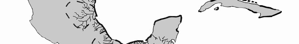

4 Fig The Gulf of Mexico drainage basin (from Moreno-Casasola 1999). 694
5 The continental shelf and the 11,018 km 2 of freshwater and brackish ecosystems cover a total area of 491,618 km 2. This is a key area for the feeding, breeding, and reproduction of a large number of species. Five sea turtle species nest on more than 20 beaches. More than 627 resident and migratory bird species depend on its wetlands for protection, feeding, and reproduction. In addition, at least 249 land and 24 marine mammal species, as well as 329 fish species, rely on this critical area (Zárate-Lomelí et al. 2004). Important coral reef formations are located on the continental shelf, as well as over 25 reefbanks found from the Tamiahua Lagoon (northern Veracruz) to the Yucatán Shelf (Campeche Bank) where Arrecife Alacrán, one of the largest reefs in all of the greater Caribbean is found. Occurring in these formations are more than 39 stony hydrocoral and scleractinian species; at least 29 gorgonacean species, over 46 macroalgae and 56 reef fish species (Zárate- Lomelí et al. 2004). Beyond the continental shelf, the oceanic zone is very rich in echinoderms, mollusks, polychaetes, fishes, marine mammals, crustaceans, and lower invertebrates (Arriaga et al. 1998). BIODIVERSITY CONSERVATION In the Mexican coastal zone of the Gulf of Mexico, there are 11 protected natural areas (PNAs), nine of which belong to the Sistema Nacional de Áreas Naturales Protegidas (SINAP; National System of Protected Natural Areas); of the remaining two, one is private and the other, municipal (Fig. 38.2). Among the PNAs included in the SINAP, there are five Biosphere Reserves, all located on the coastal plain and only one of which, namely the Los Tuxtlas Biosphere Reserve, contains terrestrial ecosystems. The two National Parks are reef systems; the area de Protección de Flora y Fauna (Flora and Fauna Protected Area) is a coastal lagoon; in the category of Sanctuary, with a beach; and, lastly, is the Ciénega del Fuerte in the Veracruz, which is a municipal protected area. In the Gulf of Mexico, there are research facilities only at the Centro de Investigaciones Costeras de La Mancha (CICOLMA; La Mancha Coastal Research Center) of the Instituto de Ecología, A.C. and at the Términos Lagoon station of the National Autonomous University of Mexico (UNAM). In the entire Gulf of Mexico Region, there is just one aquarium, in the Port of Veracruz. The total protected area is 1,980 km 2, which can be broken down into 42.8% rias (similar to everglades) and lagoons, 0.2%, beaches, 19.5%, coral reefs, 29.6%, swamps, marshes, and petenes (freshwater springs), and 7.8%, terrestrial communities. These figures indicate that this group of protected natural areas does not significantly represent the diversity of the Gulf s ecosystems and communities. Least represented are terrestrial ecosystems on the coastal plain, especially tropical dry and moist forests, lowland oak forests, and natural grasslands (Fig. 38.2). Although the Gulf of Mexico Region enjoys greater biodiversity than coastal zones in the Mexican Pacific and the Gulf of California, it has a smaller number and area of PNAs (Fig. 38.3; Moreno-Casasola 2004). Despite the above, information about what should be conserved in the Gulf of Mexico is available in catalogs on priority regions for conservation prepared by the Comisíon Nacional para el Conocimiento y Uso de la Biodiversidad (CONABIO; Mexican National Commission for the Knowledge and Use of Biodiversity). In the chapter on Priority Marine Regions (1998), CONABIO identified 16 coastal and 3 marine regions; in the chapter on Priority Terrestrial Regions (2000), 12 areas were identified and in the chapter on Priority Hydrological Basins (2002), eight areas were defined (Fig. 38.4). Several of these priority areas coincided with some 695


6 Fig Protected natural areas, Gulf of Mexico coastal zone (data from Moreno-Casasola 1999) Fig Area of coastal reserves (Moreno-Casasola 2006). 696
7 Fig Priority marine, terrestrial, and watershed regions. Numbers correspond to those appearing in Figure Source: Adapted from Arriaga et al. (1998, 2000, 2002). of the marine and terrestrial areas belonging to SINAP areas in the coastal zone and for this reason, those areas are top conservation priorities. The watersheds identified as priority also coincide with the eight major coastal systems. It is interesting to note the correspondence between marine and terrestrial systems and river basins, which clearly reflect interaction of terrestrial, marine, and freshwater ecosystems in the Gulf of Mexico (Fig. 38.4). There are few protected natural areas in this region, despite the fact that environmental deterioration calls for urgent solutions, that there are good possibilities for conservation and that decrees to establish protected areas do not pose large problems due to low population density and few urban areas. However, there are no plans to establish PNAs in any of the six Gulf coastal state even with the widespread knowledge of the importance of conserving areas such as the Alvarado Lagoon and Papaloapan Wetlands System, the Tamiahua-Pueblo Viejo lagoons, and the Laguna Madre. The best known biological diversity in the Gulf of Mexico is found in its wetlands, coastal lagoons, and tidelands. However, there is only a limited amount of information available on this diversity aside from the continental shelf and the terrestrial ecosystems located on its coastal plains. Terrestrial ecosystems are where the rivers that drain into the Gulf begin: tropical moist forests, xerophyllous scrub, tropical deciduous forests, montane cloud forests, conifer forests, and oak forests. These terrestrial formations and communities on the coastal plains shape the landscape along the coast. The physical conditions characteristic of this zone are very unique because the winds, tides, hurricanes and tropical storms, and floods affect the conditions of 697
8 sandy and rocky soils. Disturbance is a constant feature in the coastal zone, and the flora and fauna combine and recombine as they colonize and recolonize disturbed spaces. These natural systems are unique due to their vulnerability to disturbance and constant change. Landscapes on the coastal plain are the result of species displacement from mid-altitudes towards the plain and all along the coast (Guevara 2004). If we take the above into account, we can understand the system involving flows of water, matter, and energy, as well as those of plant and animal species that move between the plateaus and the coast as well as their movements within the coastal plain. Therefore, it is possible to better visualize the complex structure and dynamics of coastal communities and landscapes. This knowledge concerning ecosystem interaction and integration enables us to describe the current situation and future prospects for conservation, restoration, and use, as well as the utilization of natural resources throughout the entire historical period in which these regions have been inhabited. A FRAGMENTED WORLD The Gulf of Mexico is a fragmented world (Carré and De Séguin 1998). The world s ancient history, up to the time of the discovery of America, took place in the Mediterranean Sea and its environs. In turn, recent history (from 1500 to the present) has unfolded in the Caribbean Sea and the Gulf of Mexico and surrounding areas, and this has had major implications for the Gulf. The Spanish Empire, that conquered and colonized the American continent and islands, became increasingly detached from these colonies between the seventeenth and nineteenth centuries, giving rise to about 30 political entities in the Caribbean and another five in the Gulf of Mexico (Fig. 38.5). Mosaics of states, peoples, and cultures were formed, with European and African influences weakening indigenous cultures through both syncretism and mixing of races. This gave rise to unstable societies where conflicts turned into violent events or civil wars, even up until the present (Carré and De Séguin 1998; Fig. 38.6). Pre-Hispanic cultures and societies in Mesoamerica and the circum-caribbean region were initially colonized by Spain, then later France, England, and the Netherlands, countries. These countries used violence to consolidate their power in the Antilles where Spain had been unable to defend its possessions. In time, France founded the Company of the American Islands (1635), the Netherlands, the Dutch West India Company (1621), and England intervened in international litigations. So, they gradually came to control the Antilles and reap vast economic benefits. Plantations and mines on the islands were worked by African slaves that came to this region in great numbers (Carré and De Séguin 1998). Because of the success of agricultural and mining operations, conflicts arose in Europe. The Age of the Enlightenment embroiled France and Spain in major political instability, giving rise to the appearance of another national power in the Greater Caribbean Region, i.e., the United States of America. With great political and economic vision, the U.S.A. took advantage of tensions among the Europeans purchasing Louisiana from the French in 1803 and Florida from Spain in Subsequently, during the confusion and social and political turmoil brought about by the struggles for independence in the Americas, the United States managed to get Mexico to cede the territory of Texas to it in 1836, with which it came to hold a prominent place in the Gulf of Mexico and the Caribbean. 698
9 Fig Political divisions of the Gulf of Mexico and the Caribbean (adapted from Carré and de Séguin 1998). The fragmentation of the Caribbean and the Gulf of Mexico limited the predominance of the European countries and favored penetration of U.S. interests. Today regional integration is occurring under the aegis of the United States, formerly the ambition and motivation of the actions undertaken by colonial European powers. North American integration was promoted by the Monroe Doctrine in 1823 and reaffirmed by the Alliance for Progress in More recently, regional integration and fragmentation have continued through programs for utilizing natural resources, conserving biodiversity, and ensuring economic and social wellbeing that have been included in the free trade agreements. These treaties represent a new vision and desire, on the part of European, Asian, and North American countries or consortia, a new scheme for both independence and dependence for the Gulf of Mexico and the Caribbean (Fig. 38.7). The diversity of Mesoamerican and circum-caribbean cultures, as well as their spatial distribution, as complex as they already were, became even more so due to the effects of European colonization. Later, social movements and wars of invasion and independence produced an unimaginable variety of land uses, forms of production, and development models. 699


10 Fig Examples of population distribution by ethnic group (adapted from Carré and de Séguin 1998). 700
11 Fig Regional free trade agreements (adapted from Carré and de Séguin 1998). These then took the form of various kinds of agriculture, cattle-raising, mining, and forestry, as well as distinct patterns of settlement, urbanization, and communications. This region s economic, social, and political situation from the sixteenth century to the present has been uncertain and unstable. This history is reflected in current patterns of emigration. Due to critical economic or political circumstances, people are forced to move to various European countries and the United States (Fig. 38.8). THE SUM OF ALL THE BOUNDARIES The Gulf of Mexico is the sum of all the boundaries. It is a multidimensional border between the plateaus and the ocean, the terrestrial and the aquatic, saltwater and freshwater, the continental shelf and blue waters, and the tropical and the subtropical, as well as cultures and societies, economic structures and development models, and states and countries on the coasts between North and Central America, between the Caribbean and South America, and perhaps even between Asia and Europe. The interfaces or boundaries between conditions or components make the Gulf a complex system which, from a structural standpoint, is very rich, but from a functional standpoint, is 701
12 Fig Migration in the Gulf of Mexico and the Antilles (adapted from Carré and de Séguin (1998). problematic. This region s situation changes easily due to natural, social, economic or political factors. Over time and in space, borders shift and the direction and intensity of exchanges across the borders are also modified. A model of the Gulf of Mexico based on this concept of multidimensional boundaries results in analysis and reinterpretation of the relationships between humans and between humans and nature. Boundaries may be defined in space and/or time. They depend upon political, economic, social or natural processes, are semi-permeable, and subordinated to one another. Each boundary has a specific outline for a certain period of time, and its permeability varies, thus modifying the intensity and direction of the flow of ocean currents, winds, plant and animal migrations, and the movement of goods, energy resources, population, freshwater runoff, natural resources, and cultures, etc.. All of these are influenced by the compression and decompression exerted by the political, economic, social or natural conditions of the region, and even from outside the Gulf of Mexico itself. This is the ideal environmental, social, economic, and cultural scenario for international cooperation in the Americas geared to integrating this fragmented world of the Gulf of Mexico. It poses a challenge for the establishment, conservation, and restoration of biological diversity, 702
13 cultural diversity, and social well-being and the quality of life, a challenge never before seen in the Gulf of Mexico. RETURN TO THE SEA Since the Neolithic Age, population growth has taken place on coasts: 25% of Earth s inhabitants live within a 25-km-wide coastal belt, and 60% live within a belt measuring 200 km. Nearly 80% of the world s largest cities are located on coasts. In the year 2000, the population of Mexico was 100 million, distributed as follows: 60% in cities, 13% in semiurban zones, and 27% in rural zones (INEGI 2004). Fifty-four percent of the population lives in non-coastal states, while 46% live on the coast. Two-thirds of these inhabitants are on the Pacific, and the other third on the Gulf of Mexico and the Caribbean. The states containing the largest populations in coastal municipalities are: Baja California, Baja California Sur, Sinaloa, Sonora, Nayarit, Campeche, and Quintana Roo. In contrast, in the states of Jalisco, Michoacán, Oaxaca, Chiapas, and Yucatán we find a predominance of population living in inland settlements. At present, of the country s 126 largest cities, 48 are coastal (Garza and Rivera 1995). As a country, Mexico is characterized by its plateaus and a majority of its inhabitants live in the highlands and mountains, at altitudes ranging from 1,000 to 2,000 m above sea level, even though the plateaus only occupy about one-fourth of Mexico s territory. In the country s geography, there are very few places located at more than 500 km from the ocean (Rzedowski 1981). That means it is influenced to a great degree by the ocean surrounding it. Despite this, Mexico is the only maritime country in which its ports are not among its largest cities (Carré and De Séguin 1998). What a paradox that the coast in Mexico is so vast and yet has almost no influence over the country s economy and culture; Mexicans are aloof and disinterested when it comes to their country s oceans and coasts. Inland, we find no awareness of the coast and its significance (León 2004). This situation is closely related to how Mexico has been occupied. Mexico City, the capital of the country, was also the capital of the Viceroyalty of New Spain, and was initially the capital city of the Aztec Empire. These events, involving successive superposition, reveal origin of the centralist tendency that has prevailed from then until now. In turn, the city and the central plateau have ordered and organized Mexican space: population distribution and growth, economic and social development, and general culture. The territory is divided into major regions or zones defined by their respective commercial, economic, and political relationships. These are regions sharing communications, production sources, markets, and cultural models, and are all joined together around the central region. Figure 38.9 shows some of the most important regions; the most outstanding coastal regions are that of the Gulf of Mexico and the central and southern Pacific Coast, which are small in comparison to the central and northern regions of the country. This comparison is based on the size of the urban network giving coherence to each. Development in coastal regions depends almost exclusively on primary activities and tourism, whereas development in the central and northern regions is mostly due to large cities and industrial zones. Economic flows between these regions goes from the coasts towards the center, and from there to the north, passing through a large, more or less unarticulated region that extends all along the border with the United States, from Tijuana to Matamoros. 703
14 Fig The organization of space in Mexico (adapted from Carré and De Séguin 1998). Figure shows the destination of economic and migration flows from Mexican regions to the other side of the Mexico-U.S. border. The principal flow from the central part of the country splits in two in the northern region. Flows from the west, via Sonora and Baja California, are destined for coastal California, particularly the Los Angeles and San Francisco areas, whereas flows from the east, by way of Chihuahua and Nuevo León, reach the Texas coast, particularly the cities of Dallas and Houston. Paradoxically, from an economic and social standpoint, Mexico is more closely linked to the U.S. coast than to its own coasts on the Pacific, Gulf of Mexico or Caribbean. The explanation for Mexico s single-mindedness with regard to inland areas dates back to ancient times. Mesoamerican peoples were not sailors but they utilized wetlands and rivers as channels of communication and, at times, traveled along portions of the coast. However, in general, the ocean was not used for transportation. Their communications were strictly terrestrial, and their routes and roads were well-defined and maintained, with adequate supporting infrastructure along the length and breadth of the plateaus and mountain passes. These terrestrial connections were taken advantage of by the colonial government to fragment and divide both the land and its inhabitants into a design suited to meet its economic and political ends. This situation also favored the Spanish productive system, which was based 704
15 Fig Relationship between Mexico and the United States: industry, maquiladoras, and migration (adapted from Carré and de Séguin 1998). on agriculture, cattle-raising, and mining on soils in semiarid zones. In addition, the largest veins of precious minerals were located in mountains surrounding the plateaus. That accounts for why most of the population resided and continues to reside above an altitude of 500 m, even though water is most available below that altitude (León 2004). Another important reason why inland areas were privileged in comparison to the coast was that in the latter, there were few or perhaps no naturally sheltered ports. In fact, there were only a rather limited number of sites that were more or less appropriate for port development. We should also remember that Spain lost its islands in the Americas and a good part of its coasts to France, Portugal, England, and the Netherlands due to its lack of an efficient communications and supply system between the islands and the coasts. This was unlike the British system, whose control and administration was grounded on the mobility of its commercial fleet and well-organized, powerful navy, which allowed it to establish its presence on islands and coasts. It is curious how, thanks to their military capacity, the British came to create artificial, mobile islands formed by fleets of ships serving as administrative and decisionmaking centers, assigning them the power to control vast expanses of the ocean and the coasts. 705
16 Last but not least, there is the fact that plateaus are at lower risk of natural disasters than the coast, which is subject to the will of the winds, seasonal and annual variations in sea level, the courses and volumes of rivers and rainfall, and poor, unstable soils plagued by unhealthy wetlands and swamps. In reference to this, Alexander von Humboldt once said: Mexico is protected by its very coast (Siemens, pers. comm.). Now, after more than five centuries of civilization in the plateaus, these regions begin to show signs of exhaustion. This decline is attributable to the loss of soil fertility, decreases in the quantity and quality of water available, saturation of urban settlements, poor air quality, and depletion of natural resources. Although Spanish colonization spread over vast territories of the Americas, this situation of isolation on the plateaus only occurred in Mexico and Guatemala (Carré and De Séguin 1998). This peculiarity may, in fact, guarantee our future, and change us from a country that only looks inward to one that also looks towards the sea. Coasts and coastlines constitute a reservoir for food, energy resources, trade, and tourism. So taking advantage of the coasts, especially those along the Gulf of Mexico, will not only bring great riches, but could also transform Mexico into a country more open to the world. The coast acts as a bridge connecting states and nations, and provides a magnificent opportunity to achieve sustainable development. To this end, the challenge consists of creating a new culture and a different relationship between society and nature. We have to pave the way so that, in the near future, we may start to have closer rapport with the sea, our next frontier. The material basis of Mexico s future subsistence and development lies in the rational use of its coasts. There needs to be a new development model for the country that brings together the plateaus and coasts that will enhance production in coastal zones. This would help alleviate pressures on plateau ecosystems so that there condition can improve and their environmental services can be recovered. The up-and-down long-term model means that the status of ecosystems in the plateaus would be regulated by their effects on the coast, and that the productivity of the latter would ameliorate the environmental situation of the former. This is a rational, global, and integrated model for Mexico, and very likely represents the last call for a new relationship between Mexican society and its natural surroundings. RESOURCES OF THE GULF OF MEXICO The Gulf of Mexico is the region containing Mexico s richest natural resources: fishing resources, energy resources, aquifers, agricultural-livestock resources, and forest resources, and we could even include, as different kinds of resources, national and international communications and the availability of space. The basis for this wealth of resources is the Gulf s biological diversity, probably the greatest to be encountered at a regional scale in the American continent. Fisheries are considered the second most important coastal resource for the region (after oil), with over 350,261 tons/year of coastal demersal resources valued at approximately 240 million dollars, providing employment for more than 90,000 people. Over 30,000 tons of shrimp, 49,000 tons of oyster and 2,000 tons of clams are harvested annually. In addition, lobster, octopus, crab, grouper, porgy, red snapper, corbina, sea bass, mojarra, and shark are caught. In 1990, agriculture encompassed 2,172,467 ha and produced 4,227,923 tons of corn, beans, rice, soybean, safflower, and sorghum. 706
17 More than 80% of the country s crude oil and 90% of its natural gas are produced in the Gulf of Mexico. This region has vast energy resources; oil deposits in the Villahermosa Basin and the Campeche Bay are deemed to be among the largest such deposits in production in the Western Hemisphere. Mexico has a huge, complex infrastructure for extracting, processing, storing, and transporting oil and its by-products, as well as refineries, petrochemical plants, platforms, and pipelines. The availability of these high-yield natural resources for domestic consumption and exportation serve to further substantiate the argument concerning the Gulf of Mexico s potential for the country s future development. USING RESOURCES OR LETTING THEM BE The quantity of natural resources extracted from the Gulf is immense and their potential for use is even greater. This is mainly because Mexico is currently a strong exporter, holding first place in exports in all of Latin America, accounting for approximately 60% of the total for all the countries. It has nine of the ten leading exporting firms of autos, oil, cement, and electrical products in the region. However, the Mexican merchant marine is virtually non-existent: the country lacks a maritime transport system for carrying its exports, which is essential for foreign trade development. The growth of Mexican ports is the result of policies fashioned in the twentieth century. As early as 1935, President Lázaro Cárdenas acknowledged lack of the Mexican merchant marine and the importance of creating and developing this type of force, a responsibility that was assigned, years later, to PEMEX. In 1959, President Adolfo Ruiz Cortines founded the Program for Maritime Progress, known as the Marcha al Mar (March to the Sea), which consisted of moving inhabitants in great numbers from the plateaus to the coasts, thus taking advantage of the ocean s riches. This program included development of maritime port network, construction of shipyards, improvement in communications and transportation between ports, and laid the groundwork for development of the merchant marines. In 1976, that task was given to the Ministry of the Navy and in 1977, it was transferred to the Secretaria de Comunicaciones y Transportes (Ministry of Communications and Transportation). During the administrations of presidents Luis Echeverría and José López Portillo, the Mexican oil fleet was the largest in Latin America. However, after that time it began to lose its strength and has continued to decline, with 98% of import and export freight currently transported by ships flying foreign flags and run by 114 shipping companies. Forty-five percent of all permits requested are for U.S. ships, with 12%, requested by Vanuatu (a group of islands in the South Pacific) and Panama; 10%, by Liberia, St. Vincent and the Grenadines, and the Bahamas, and the remaining 21% by European and Asian countries. Coastal trade in Mexico is not protected as it is in the United States by the Jones Act (also known as the Merchant Marine Act), which forbids foreign ships from conducting trade. Moreover, in terms of hydrocarbon shipping payments, PEMEX sets lower prices for foreign firms than for Mexican ones; between these discounts and the fact that in Mexico, firms have to pay the value-added tax, they end up paying 18%-20% more. Tourism has developed in the Gulf of Mexico in an uncontrolled fashion. Unfortunately, the predominant tourism model fails to take into account the natural and social environment and occupies space in an arbitrary, disorganized way. This results in a lack of coordination among 707
18 natural, social, and economic processes, and threatens to compromise its future development and sustainability. Extraction of renewable and non-renewable natural resources in the Gulf of Mexico is not based on a plan for developing exports that includes creating infrastructure such as port and transportation facilities; and the disorderly growth of tourism only compounds major deterioration resulting from productive and extractive activities. Outstanding is the effect of the oil industry, as well as deforestation caused by the advance of the agricultural-livestock frontier. Currently, 40% of the total area of the six Mexican states bordering the Gulf has lost its original vegetation cover. In addition, agricultural and urban development in the highlands causes pollution in rivers, estuaries, coastal lagoons, and wetlands, and affects fishing production in general. If urban, industrial, agricultural-livestock, and tourist development all continue as they have until now, without a regional development plan for the Gulf of Mexico and following clandestine land-use and planning initiatives at the local level, environmental degradation and the loss of natural resources will be irreversible. This will result in exorbitant investments in infrastructure, uncontrolled population growth and dangerous social deterioration, dangerous. Thus, this will be a region of conflict, rather than one offering an opportunity for Mexico s future. THE OUTCOME The Gulf of Mexico is the most important current and potential source of natural resources in Mexico. However, at the same time it is one of the country s most seriously degraded and environmentally affected regions. It offers us a great opportunity to achieve harmonious development. Very little inter-institutional and multidisciplinary work has been done to define the Gulf of Mexico geographically, socially, and economically, and because of this shortcoming, development plans designed at different scales are incomplete and disjointed and, thus, not functional. Although certain national and international political, social, and academic organizations focusing on the Gulf of Mexico have been created, they still lack the necessary capacity to analyze, identify, and propose elements for a development plan in this region. The absence of precise definitions for the Gulf and of agreements and coordination limit plans to regionalize the Gulf of Mexico, which constitutes the basis for regional development in the Americas. Yet we should not overlook the efforts and proposals made to advance in that direction, among which the following are outstanding: The Gulf of Mexico Program, designed by the U.S. Environmental Protection Agency (EPA) in The Business Council for Sustainable Development of the Gulf of Mexico (BCSD-GM) The U.S.-Mexico Partnership for the Gulf of Mexico The International Treaty of the Seas The North American Free Trade Agreement (NAFTA) The Agreement for Economic Development of the Wider Caribbean Basin Mexico should propose, as a strategic goal for its development and growth, to incorporate the Gulf of Mexico region into the rest of the country for the purpose of visualizing a new project based on a different qualitative and quanitative relationship between Mexican society and the environment that is more productive, equitable, and future-oriented. In addition, this will enable 708
19 Mexico to establish greater rapport with the other countries in the Gulf of Mexico/Caribbean region, and with the world as a whole. ACKNOWLEDGEMENTS Graciela Sánchez Ríos gathered information, did the data processing, and corrected the text; Kerenha Hernández collected data and prepared the figures and graphs; Patricia Moreno- Casasola generously shared her information with me; Alfred Siemens made very valuable.appreciably in both coherence and quality. LITERATURE CITED Arriaga, L., V. Aguilar, and J. Alcocer Aguas Continentales y Diversidad Biológica de México. México, D.F.: Comisión Nacional para el Conocimiento y Uso del la Biodiversidad (CONABIO)., J. M. Espinoza-Rodríguez, C. Aguilar-Zúñiga, E. Martínez-Romero, L. Gomez- Mendoza and E. Loa-Loza (eds.) Regiones Terrestres Prioritarias de México. México, D.F.: Comisión Nacional para el Conocimiento y Uso del la Biodiversidad (CONABIO)., E. Vázquez-Domínguez, J. González-Cano, R. Jiménez Rosenberg, E. Muñoz López and V. Aguilar Sierra (eds.) Regiones Marinas Prioritarias de México. México, D.F.: Comisión Nacional para el Conocimiento y Uso de la Biodiversidad (CONABIO). 195 pp. Carré, F. and A. De Séguin Mexique, Golfe, Caraibes: Une Méditerranée Américaine? Paris: Presses Universitaires de France. 264 pp. Garza, G. and S. Rivera Dinámica Macroeconómica de las Ciudades de México. Aguascalientes, México: INEGI-COLMEX. Guevara, S El paisaje del viento. Pp in P. Moreno-Casasola (ed), Entornos Veracruzanos: La Costa de La Mancha. Xalapa, Veracruz, México: Instituto de Ecología, A.C.. INEGI León, C Piezas de un rompecabezas: dimensión socio-económica de las costas de México. Pp in A. E. Rivera, G. Villalobos, I. Azuz A. and F. Rosado, M. (eds.), Manejo Costero en México. México, D.F.: SEMARNAT, Universidad Autónoma de Campeche, CETYS Universidad, Universidad de Quintana Roo Moreno-Casasola, P Dune vegetation and its biodiversity along the Gulf of Mexico, a large marine ecosystem. Pp in H. Kumpf, K. Steidinger and K. Sherman (eds.), The Gulf of Mexico Large Marine Ecosystem: Assessment, Sustainability and Management. Malden, Massachusetts: Blackwell Science Beaches and dunes of the Gulf of Mexico: a view of the current situation. Pp in M. Caso, I. Pisanty and E. Ezcurra (eds.), Diagnóstico Ambiental del Golfo de México. México, D.F.: Instituto de Ecología, A.C. (INE-SEMARNAT).. (ed) Entornos Veracruzanos: La Costa de La Mancha. Xalapa, Veracruz, México: Instituto de Ecología, A.C. Rzedowski, J La Vegetación de México. México, D.F.: LIMUSA. 709
20 SEGOB Atlas Nacional de Riesgos. Dirección General de Protección Civil, Secretaría de Gobernación. México, D.F.: Editorial Mac, S. A. de C. V., SEGOB Prontuario de Consecuencias en el siglo XX Mexicano. México: D.F.: Subsecretaría de Protección Civil y de Prevención y Readaptación Social, Secretaria de Gobernación, Toledo, A Un patrimonio natural irremplazable. La Jornada Ecológica, Suplemento Marzo 1998: Al Rescate del Golfo de México. México, D.F.: UNAM. Zárate-Lomelí, D., A. Yánez-Arancibia, J. W. Day, M. Ortiz-Pérez, A. Lara-Domínguez, C. Ojeda de la Fuente and S. Guevara Lineamientos para el programa regional de manejo integrado de la zona costera del Golfo de México y Caribe. Pp in M. Caso, I. Pisanty and E. Ezcurra (eds.), Diagnóstico Ambiental del Golfo de México. México, D.F.: Instituto de Ecología, A.C. (INE-SEMARNAT). 710
Mexican Sub-National Governments International Relations In North America
 Voices of Mexico 103 Mexican Sub-National Governments International Relations In North America Jorge A. Schiavon* Daniel Becerril / Reuters Introduction Traditionally, foreign policy has been controlled
ECOREGIONAL ASSESSMENT EQUATORIAL PACIFIC EXECUTIVE SUMMARY
 ECOREGIONAL ASSESSMENT EQUATORIAL PACIFIC The Nature Conservancy, Fundación Agua, EcoCiencia, Fundación Jatun Sacha, CDC Ecuador, CDC UNALM 2004. Portafolio de Sitios Prioritarios para la Conservación
An NPS Wetland of International Significance!
 An NPS Wetland of International Significance! A World Class Tourism Destination Linda Friar Chief of Public Affairs 305-242-7714 Linda_Friar@nps.gov The Everglades - International Recognition as a special
Regional Economic Report July- September 2014
 Regional Economic Report July- September 2014 December 11, 2014 Outline I. Introduction II. Results July September 2014 A. Economic Activity B. Inflation C. Economic Outlook III. Final Remarks Introduction
Applying Geospatial Tools to Produce Data for SDG Indicators in Mexico
 Applying Geospatial Tools to Produce Data for SDG Indicators in Mexico Inter-Agency and Expert Group On SDGs Indicators Enrique Ordaz Francisco J. Jimenez Stockholm November 2018 Background INEGI has produced
6th Grade Western Hemisphere Geography
 6th Grade Western Hemisphere Geography Multiple Choice Identify the choice that best completes the statement or answers the question. 1 Latin America is located in the A Northern Hemisphere. C Western
REDD+ IN YUCATAN PENINSULA
 REDD+ IN YUCATAN PENINSULA JOINING FORCES TO PRODUCE AND PRESERVE 2 3 Campeche, Yucatan, and Quintana Roo combat deforestation together in the Yucatan Peninsula and build a new path for growth A peninsular
Mexico. Chapter 10. Chapter 10, Section
 Chapter 10, Section World Geography Chapter 10 Mexico Copyright 2003 by Pearson Education, Inc., publishing as Prentice Hall, Upper Saddle River, NJ. All rights reserved. Chapter 10, Section World Geography
CHAPTER 12. South America. Section 1: Natural Environments Section 2: History and Culture Section 3: South America Today. HOLT World Geography
 CHAPTER 12 South America Section 1: Natural Environments Section 2: History and Culture Section 3: South America 1 Section 1 Natural Environments Objectives: What are the major landforms and rivers of
Regional Economic Report April June 2013
 Regional Economic Report April June 213 September 12, 213 Outline I. Introduction II. Results April - June 213 A. Economic Activity B. Inflation C. Economic Outlook III. Final Considerations Introduction
Regional Economic Report April June 2012
 Regional Economic Report April June 2012 September 13, 2012 Outline I. Introduction II. Results April - June 2012 A. Economic Activity B. Inflation C. Economic Outlook III. Final Considerations Introduction
TOWARDS SUSTAINABLE MANAGEMENT OF MARINE AND COASTAL HABITATS ASIA- PACIFIC DAY FOR THE OCEAN
 TOWARDS SUSTAINABLE MANAGEMENT OF MARINE AND COASTAL HABITATS WANNAKIAT THUBTHIMSANG PHUKET MARINE BIOLOGICAL CENTER, DMCR, THAILAND ASIA- PACIFIC DAY FOR THE OCEAN 20 NOVEMBER 2018, CONFERENCE ROOM 4,
Latin America. Chapter 9 Physical Geography
 Latin America Chapter 9 Physical Geography Latin American Regions Middle America includes Mexico and the Central American countries The Caribbean Islands South America Mexico Landforms Sierra Madre Oriental
Latin America and The Caribbean. A Closer Look.
 Latin America and The Caribbean A Closer Look. Mexico Capital: Mexico City The Location of Mexico Mexico is the second-largest country by size and population in Latin America.but the Largest Spanish -
Mediterranean Europe
 Chapter 17, Section World Geography Chapter 17 Mediterranean Europe Copyright 2003 by Pearson Education, Inc., publishing as Prentice Hall, Upper Saddle River, NJ. All rights reserved. Chapter 17, Section
2018 Spring Semester Final : STUDY GUIDE
 Name: Hr: 2018 Spring Semester Final : STUDY GUIDE My final is on:, May My final will have questions and will be COLONIZATION OF NORTH & SOUTH AMERICA - Match the regions with the European countries that
6th Grade Third Nine Weeks Benchmark Assessment
 6th Grade Third Nine Weeks Benchmark Assessment Multiple Choice Identify the choice that best completes the statement or answers the question. Key Concepts 1 Latin America is located in the A Northern
Regional Economic Report April June 2015
 Regional Economic Report April June 2015 September 10, 2015 Outline I. Regional Economic Report II. Results April June 2015 A. Economic Activity B. Inflation C. Economic Outlook III. Final Remarks Regional
INDUSTRY DEFINITION THE SEAFOOD INDUSTRY IN MEXICO
 SEAFOOD INDUSTRY INDUSTRY DEFINITION Aquaculture is the controlled production by man of vegetable and animal organisms which spend at least some of their life cycle in a water environment. These organisms,
LATIN AMERICA / CARIBBEAN COIBA NATIONAL PARK PANAMA
 LATIN AMERICA / CARIBBEAN COIBA NATIONAL PARK PANAMA WORLD HERITAGE NOMINATION IUCN TECHNICAL EVALUATION COIBA NATIONAL PARK (PANAMA) ID Nº 1138 Bis Background note: Coiba National Park was nominated for
Latin America 11/4/2013. Latin America Today. 580 million people 9% of the world s population Diverse backgrounds:
 Latin America Chapter 10 Human Geography Latin America Today 580 million people 9% of the world s population Diverse backgrounds: Native Americans Europeans Africans Asians 1 Population 393 million live
UNIT 3 Extra Review for Chapters 9-11
 UNIT 3 Extra Review for Chapters 9-11 Mexico Central America Caribbean Islands Middle America is Central America, Mexico, and the Islands of the Caribbean Central America is a region within Middle America.
Methodology. Results. Table 1. Summary of Strengths (S), Weaknesses (W), Opportunities (O) and Threats (T) to promote the Mayan Zone of Quintana Roo.
, Weaknesses (W), Opportunities (O) and Threats (T) to promote the Mayan Zone of Quintana Roo.") Introduction Promoting a developmental tourism in the Mayan Zone of Quintana Roo is one of the government s main issues, so in the National Development Plan 2006-2012, in the line of action 2, it considers
Introduction Promoting a developmental tourism in the Mayan Zone of Quintana Roo is one of the government s main issues, so in the National Development Plan 2006-2012, in the line of action 2, it considers
2012. Proceedings of the 11 European Geoparks Conference. AGA Associação Geoparque Arouca, Arouca, 5-6.
 References to this volume It is suggested that either the following alternatives should be used for future bibliographic references to the whole or part this volume: th Sá, A.A., Rocha, D., Paz, A. & Correia,
CHAPTER Latin America. Regional Atlas Study Guide. 2 Chapter A. As You Read. B. Reviewing Vocabulary
 CHAPTER 28 9 Many Th ew inventions new Regional Atlas Study Guide Latin America Directions: As you work through the Regional Atlas, complete the chart below by writing two details about each Latin American
GUIDELINES FOR THE REGIONAL INTEGRATED COASTAL ZONE MANAGEMENT PROGRAM OF THE GULF OF MEXICO AND THE CARIBBEAN
 GUIDELINES FOR THE REGIONAL INTEGRATED COASTAL ZONE MANAGEMENT PROGRAM OF THE GULF OF MEXICO AND THE CARIBBEAN D. Zárate Lomelí, A. Yánez-Arancibia, J. W. Day, M. Ortiz Pérez, A. Lara Domínguez, C. Ojeda
Latin America. Introduction
 Latin America Introduction What are the 5 Themes of Geography? Draw lines to connect the theme to the definition: Location How humans and the environment impact each other Physical and human characteristics
ECORREGIONAL ASSESSMENT: EASTERN CORDILLERA REAL ORIENTAL PARAMOS AND MONTANE FORESTS
 ECORREGIONAL ASSESSMENT: EASTERN CORDILLERA REAL ORIENTAL PARAMOS AND MONTANE FORESTS The Nature Conservancy, EcoCiencia y Fundación AGUA. 2005. Evaluación Ecorregional de los Páramos y Bosques Montanos
Case Study: 1. The Clarence River Catchment
 Case Study: 1. The Clarence River Catchment The NSW coastline is a great natural asset, making an enormous contribution to the economy. The resources of coastal catchments such as the Clarence River Catchment,
THE IMPORTANCE OF THE RURAL TELEPHONE LINE SATELLITE IN MEXICO
 THE IMPORTANCE OF THE RURAL TELEPHONE LINE SATELLITE IN MEXICO Cirilo Gabino León Vega, Oscar Dolores Vázquez, Ramón Marín Solís Correo electrónico: cleonv@ipn.mx,oscarvazq@hotmail.com, rmarins@gmail.com
The Geological Pacific Northwest. Wednesday February 6, 2012 Pacific Northwest History Mr. Rice
 The Geological Pacific Northwest Wednesday February 6, 2012 Pacific Northwest History Mr. Rice 1 Free Response #2 Please do not simply list the items for this response. Full sentences!!! Minimum of 3-5
6th Grade Western Hemisphere Geography
 6th Grade Western Hemisphere Geography Multiple Choice Identify the choice that best completes the statement or answers the question. 1 Latin America is located in the A Northern Hemisphere. C Western
Objective. Students will familiarize themselves with the physical features and climates of Latin America.
 Journal Write KWL What do you KNOW about Latin America? What do you WANT TO KNOW about Latin America? What did you LEARN today that you didn t know before? Latin America Objective Students will familiarize
Regional Atlas: Introduction to Latin America
 Chapter 9, Section World Geography Chapter 9 Regional Atlas: Introduction to Latin America Copyright 2003 by Pearson Education, Inc., publishing as Prentice Hall, Upper Saddle River, NJ. All rights reserved.
REGIONAL AGREEMENT AND FRAMEWORK FOR MARINE MAMMALS CONSERVATION IN THE WCR: THE SPAW PROTOCOL AND THE MARINE MAMMAL ACTION PLAN
 REGIONAL AGREEMENT AND FRAMEWORK FOR MARINE MAMMALS CONSERVATION IN THE WCR: THE SPAW PROTOCOL AND THE MARINE MAMMAL ACTION PLAN ALESSANDRA VANZELLA-KHOURI SPAW Programme Officer United Nations Environment
Latin America s Physical Geography. EQ: What are characteristics of Latin America s physical features?
 Latin America s Physical Geography EQ: What are characteristics of Latin America s physical features? Your Task: We are going to participate in a Museum Walk! You will travel around the room with a partner
Mrs. Reifsnyder World Geography. Unit 8: Latin America Study Guide SOLs Addressed: WG. 1c, 2b, 3c, 4, 10b/c
 Mrs. Reifsnyder World Geography Unit 8: Latin America Study Guide SOLs Addressed: WG. 1c, 2b, 3c, 4, 10b/c Essential Questions: - In what ways do physical, economic, and cultural characteristics influence
THE SAN JUAN RIVER BASIN PROJECT
 Formulation of a Strategic Actions Program for the Integrated Management of the Hydrological Resources and Sustainable Development of the San Juan River Basin and its Coastal zone PROCUENCA SAN JUAN THE
Current conditions. Guatemala's Maya Biosphere Reserve. No clear idea of speed of deforestation. Deforestion by pollen analysis
 Current conditions Most obvious human transformation is cutting of forests Guatemala's Maya Biosphere Reserve An Eco-Friendly Adventure Along the Maya Trails Key ecological roles: repository for biodiversity
An International Journal
 An International Journal FOREWORD Gulf of Mexico Marine Labs JOHN W. TUNNELL, JR AND GEORGE F. CROZIER Published by the Marine Environmental Sciences Consortium of Alabama Gulf of Mexico Science, 2010(1
Centro de Ecología, Pesquerías y Oceanografía del Golfo de México (EPOMEX) Universidad Autónoma de Campeche, Mexico
 Universidad Autónoma de Campeche, Mexico") Gulf of Mexico Science Volume 28 Number 1 Number 1/2 (Combined Issue) Article 4 2010 Centro de Ecología, Pesquerías y Oceanografía del Golfo de México (EPOMEX) Universidad Autónoma de Campeche, Mexico
Gulf of Mexico Science Volume 28 Number 1 Number 1/2 (Combined Issue) Article 4 2010 Centro de Ecología, Pesquerías y Oceanografía del Golfo de México (EPOMEX) Universidad Autónoma de Campeche, Mexico
Introduces the topic. Diamond shape of whole essay. Diamond shape of each body paragraph
 Academic writing has a particular structure. This structure can be represented like a diamond. The diamond structure repeats on a small level in paragraphs and assignment tasks and on a larger level in
Latin America. Physical Geography
 + Latin America Physical Geography + I. Landforms A. Caribbean & Central America 1. Mexico is dominated by two mountain chains, collectively called the Sierra Madre. A high plateau is situated in between.
Xaman-Ha city, an answer to the poor growth and spread population
 Xaman-Ha city, an answer to the poor growth and spread population Global aspect In The Mexican Republic we can found three zones with an important tourist movement; the metropolitan area of Mexico City,
Geographic Qualities of South America
 Geographic Qualities of South America 1. South America is the fourth largest continent in area. It is located in the Western Hemisphere, lying southwest of North America. Most of South America lies in
Sustainable tourism in Holbox through local development
 Sustainable Tourism II 319 Sustainable tourism in Holbox through local development A. Palafox, V. Pineda, J. Godínez & M. Martínez Universidad de Quintana Roo, Mexico Abstract According to the Bank of
Exploring Mexico. Directions: Complete the paragraphs below. Write the correct word from the Word Bank to complete each sentence.
 Exploring Mexico Section 1 10 Directions: Complete the paragraphs below. Write the correct word from the Word Bank to complete each sentence. Word Bank United States Central Plateau irrigation isthmus
STANDARDS: Brain Wrinkles
 STANDARDS: SS6G3 The student will explain the impact of location, climate, distribution of natural resources, and population distribution on Latin America and the Caribbean. a. Compare how the location,
LOCATION, CLIMATE, AND NATURAL RESOURCES OF MEXICO
 SS6G3 The student will explain the impact of location, climate, distribution of natural resources, and population distribution on Latin America and the Caribbean. a. Compare how the location, climate,
ECOSYSTEM CONSERVATION WORKING TABLE ACTION ITEM REPORT XX Trilateral Committee Meeting San Diego, California April 13 17, 2015
 The Working Table conducted its working session on April 13-16, 2015. The following Items were agreed upon and address the current priorities of the Trilateral Committee. o Climate Change with a Focus
LATIN AMERICA. Mexico Central America Caribbean Islands South America
 LATIN AMERICA Mexico Central America Caribbean Islands South America HISTORY First Settlers Hunters/gatherers from Asia crossed land bridge connecting Asia and Alaska Learned to farm over time Maize (corn)
Successful Experiences in Rio Grande/Rio Bravo Watershed Management
 Successful Experiences in Rio Grande/Rio Bravo Watershed Management 5 th th World Water Forum Istanbul, Turkey March 22-23, 23, 2009 Introduction A watershed with many voices a medley of cultures, customs,
The Chemical Industry in Mexico
 The Chemical Industry in Mexico The global chemical industry 3 The relevance of the chemical industry in Mexico 5 Opportunities in the synthetic resins and rubber. 11 Why to invest in Mexico 11 The Global
Summary of Global Perspectives
 Baja California: California`s Partner José Guadalupe Osuna Millán Baja California State Governor October 2009 World Economic Outlook Summary of Global Perspectives Percentage change last year, except interest
Brain Wrinkles. Location, Climate, & Natural Resources of. Where People Live & How They Trade
 Location, Climate, & Natural Resources of Where People Live & How They Trade It s south of the US, east of the Pacific Ocean, and west of the Gulf of Mexico & Caribbean Sea. It s great that it s located
Analysis of the 2012 Mexican Presidential Elections
 1 Analysis of the 2012 Mexican Presidential Elections Yazmin Valdez, Olmo Zavala, Jorge Zavala, Elena Tai, Melina Ávila, Jorge Barreda, and Daniel Santiago June 2013 2 Abstract Historically, Mexican Presidential
THE INTERNATIONAL GROWTH OF SPANISH HOLIDAY HOTEL CHAINS FROM A GLOBAL PERSPECTIVE: A CASE STUDY
 Cuadernos de Turismo, nº 25, (2010); pp. 263-267 ISSN: 1139-7861 Universidad de Murcia THE INTERNATIONAL GROWTH OF SPANISH HOLIDAY HOTEL CHAINS FROM A GLOBAL PERSPECTIVE: A CASE STUDY Begoña Fuster García,
MARINE PROTECTED AREAS LESSON PLAN Water Parks
 Marine Protected Areas U. S. Marine Protected Areas Lesson Plan MARINE PROTECTED AREAS LESSON PLAN Water Parks Theme U.S. Marine Protected Areas Links to Overview Essays and Resources Needed for Student
Utah Nevada California Arizona New Mexico Baja California Texas Sonora Chihuahua Coahuila de Zaragoza Sinaloa Durango Nuevo León Zacatecas San Luis
 Nevada Utah California Arizona New Mexico Baja California Sonora Texas Chihuahua Coahuila de Zaragoza Sinaloa US States Mexico States International Boundary Durango Nayarit Zacatecas Jalisco Nuevo León
Just how big is Africa?
 The United States China India The United Kingdom Portugal Spain France Belgium Germany The Netherlands Switzerland Italy Eastern Europe Japan 11.7 million sq. miles Just how big is Africa? Chapter 18 Section
Information on Ecological and Biological Significant Marine Areas in Albania
 Information on Ecological and Biological Significant Marine Areas in Albania The report is assembled from the draft strategic plan for marine and coastal protected areas in Albania, supported by the GEF-UNDP
Biosphere Reserves of India : Complete Study Notes
 Biosphere Reserves of India : Complete Study Notes Author : Oliveboard Date : April 7, 2017 Biosphere reserves of India form an important topic for the UPSC CSE preparation. This blog post covers all important
Portuguese Language - Fostering National Unity
 Geography Brazil Brazil Portuguese Language - Fostering National Unity 11 dialects of Portuguese Influenced by Amerindian and African languages, creating differences between Portuguese spoken in Brazil
Dr. Christopher Brown New Mexico State University GEF Project Rio Meeting Ciudad Juárez, México 3-5 October 2006
 Political and Institutional Aspects of Rio Grande/ Río Bravo Basin Management Dr. Christopher Brown New Mexico State University GEF Project Rio Meeting Ciudad Juárez, México 3-5 October 2006 Institutional
Actual Climatic Conditions in ERB. Online Resource 1 corresponding to:
 Actual Climatic Conditions in ERB. Online Resource 1 corresponding to: Article Title: Climatic Trends and Impact of Climate Change on Agriculture in an Arid Andean Valley. Journal Name: CLIMATIC CHANGE
Establishment of Maquenque National Park to Achieve Connectivity within the San Juan-La Selva Biological Corridor
 Establishment of Maquenque National Park to Achieve Connectivity within the San Juan-La Selva Biological Corridor RESEARCH The Great Green Macaw as a flagship species to drive an innovative conservation
Latin America. Physical Geography
 Latin America Physical Geography Regions Latin America can be divided into separate regions based on physical geography or cultural geography. Regions If we look at physical geography Latin America has
Title/Name of the area: Chwaka Bay, Zanzibar
 Title/Name of the area: Chwaka Bay, Zanzibar Presented by: Dr. Charles Lugomela, Ag. Head, Department of Aquatic Sciences and Fisheries, University of Dar es Salaam, P.O. Box 35064 Dar es Salaam, Tanzania
Chapter Objectives. Describe the dominant landforms and natural resources of Southeast Asia. Discuss Southeast Asia s climate and vegetation.
 Chapter Objectives Describe the dominant landforms and natural resources of Southeast Asia. Discuss Southeast Asia s climate and vegetation. The Land Section 1 Objectives Describe how tectonic plates and
What is an Marine Protected Area?
 Policies, Issues, and Implications of Marine Protected Areas Kara Anlauf University of Idaho Before the House Subcommittee on Fisheries Conservation, Wildlife and Oceans April 29, 2003 What is an Marine
THE STATE OF ZACATECAS, MEXICO
 2016 THE STATE OF ZACATECAS, MEXICO ZACATECAS Zacatecas is a state with a lot to offer. Its capital city is one of the most beautiful colonial cities in Mexico. Thanks to its history and architecture,
The Land Photo Source: The Atlas of Canada, The Red River, Manatoba, Canada land/physio_red_ri
 The Land The United States and Canada An Overview of the Region The United States and Canada are the two largest countries in North America. The Rio Grande is part of the southwest border of the United
Discussion on the Influencing Factors of Hainan Rural Tourism Development
 2018 4th International Conference on Economics, Management and Humanities Science(ECOMHS 2018) Discussion on the Influencing Factors of Hainan Rural Tourism Development Lv Jieru Hainan College of Foreign
LAUNCH OF THE COASTAL ZONE MANAGEMENT TRUST
 A 60km stretch of coastline on the Yucatan Peninsula of Mexico is the testing ground for an idea that could protect fragile environments around the world: insuring coral reefs. The Economist World Ocean
Pilot Project for Integrated Management of the Coastal Zone of Bahia de Navidad, Jalisco, Mexico
 . EUROCOAST / EUCC, Porto Portugal Ed. EUROCOAST Portugal, ISBN 972-8558-09-0 Pilot Project for Integrated Management of the Coastal Zone of Bahia de Navidad, Jalisco, Mexico Alfredo T. Ortega Ojeda Biól.,Departamento
COUNTRY CASE STUDIES: OVERVIEW
 APPENDIX C: COUNTRY CASE STUDIES: OVERVIEW The countries selected as cases for this evaluation include some of the Bank Group s oldest (Brazil and India) and largest clients in terms of both territory
Nicaragua versus Costa Rica?
 Nicaragua versus Costa Rica? Overview: Today I want to look at Nicaragua versus Costa Rica from both a destination for retiree s standpoint and for potential investment interest. First I'll provide some
WORLD GEOGRAPHY. Hector Rodriguez
 Mr. Chavira 9th Period WORLD GEOGRAPHY Hector Rodriguez P a g e 1 Table of Contents Latin America Page 2 o Maps Economic Map Page 3 Political Map Page 4 Population Map Page 5 Physical Page 6 o Notes Physical
Dr. Dimitris P. Drakoulis THE REGIONAL ORGANIZATION OF THE EASTERN ROMAN EMPIRE IN THE EARLY BYZANTINE PERIOD (4TH-6TH CENTURY A.D.
 Dr. Dimitris P. Drakoulis THE REGIONAL ORGANIZATION OF THE EASTERN ROMAN EMPIRE IN THE EARLY BYZANTINE PERIOD (4TH-6TH CENTURY A.D.) ENGLISH SUMMARY The purpose of this doctoral dissertation is to contribute
*Latin America spans 7,000 miles, from Mexico to Tierra Del Fuego. *3 Regions: Central America, South America, and the Caribbean.
 Physical Geography Latin America spans 7,000 miles, from Mexico to Tierra Del Fuego *3 Regions: Central America, South America, and the Caribbean. *Intro clip: http://www.youtube.com/watch?v=cffp6rza3
BIGI PAN MUMA (MULTIPLE-USE MANAGEMENT AREA)
") BIGI PAN MUMA (MULTIPLE-USE MANAGEMENT AREA) EXCHANGE OF NATIONAL EXPERIENCES IN THE SPHERE OF DEVELOPMENT OF ENVIRONMENTALLY SUSTAINABLE COMMUNITY -BASED TOURISM IN PROTECTED NATURAL AREAS (ANPS) AMONG
BIGI PAN MUMA (MULTIPLE-USE MANAGEMENT AREA) EXCHANGE OF NATIONAL EXPERIENCES IN THE SPHERE OF DEVELOPMENT OF ENVIRONMENTALLY SUSTAINABLE COMMUNITY -BASED TOURISM IN PROTECTED NATURAL AREAS (ANPS) AMONG
Last updated: July 22 nd, 2015
 I. Background TOTOABA (TOTOABA MACDONALDI) AND VAQUITA PORPOISE (PHOCOENA SINUS): TWO ENDANGERED SPECIES ENDEMIC TO MEXICO Last updated: July 22 nd, 2015 1. Totoaba (Totoaba macdonaldi) is a fish endemic
Coverage of Mangrove Ecosystem along Three Coastal Zones of Puerto Rico using IKONOS Sensor
 Coverage of Mangrove Ecosystem along Three Coastal Zones of Puerto Rico using IKONOS Sensor Jennifer Toledo Rivera Geology Department, University of Puerto Rico, Mayagüez Campus P.O. Box 9017 Mayagüez,
Monitoring the Environmental Status of the Heart of Borneo
 Monitoring the Environmental Status of the Heart of Borneo By: Stephan Wulffraat The Heart of Borneo conservation initiative has been going on now for several years and has gained increasing support from
Environmental Impact Assessment in Chile, its application in the case of glaciers. Carlos Salazar Hydro21 Consultores Ltda.
 Environmental Impact Assessment in Chile, its application in the case of glaciers Carlos Salazar Hydro21 Consultores Ltda. carlos.salazar@hydro21.cl Introduction Changes in the environmental law in Chile
UNIT 5 AFRICA PHYSICAL GEOGRAPHY SG 1 - PART II
 UNIT 5 AFRICA PHYSICAL GEOGRAPHY SG 1 - PART II III. CLIMATE & VEGETATION A. The four main climate zones are tropical wet, tropical wet/dry (split into monsoon & savanna), semiarid, and arid. Other climate
 AGREEMENT Between Director of the Białowieża National Park, based in Białowieża (Poland) and Director of the National Park Bialowieża Forest, based in Kamieniuki (Belarus) and Head Forester of the Białowieża
Curriculum. Update: 2017
 Curriculum Update: 2017 MISION Our purpose goes beyond profit; our company was born to create and develop projects in the energy sector that deliver solutions our clients and the federal governments, to
The Design of Nature Reserves
 The Design of Nature Reserves Goals Maintenance of MVP s for targeted species Maintenance of intact communities Minimization of disease Considerations of reserve design 1. Disturbance regime Fire Insect
Catchment and Lake Research
 LARS 2007 Catchment and Lake Research Multilateral versus bilateral agreements for the establishment of river based organizations: comparison of legal, economic and social benefits in the Zambian experience.
ROLANDO JAVIER SALINAS GARCÍA RESUME
 javier.salinas.uaq@gmail.com México Phone +52 (442) 192-12-00 Ext. 6320 y 65508 Cel. (+52) (442) 279-17-76 EEUU: (+001) 310-206-0395 ROLANDO JAVIER SALINAS GARCÍA RESUME ADDRESS AND EMPLOYMENT Member of
Oceania. Australia, New Zealand, and the Pacific Islands. Physical Geography. Where is Australia located?
 Oceania Australia, New Zealand, and the Pacific Islands Physical Geography Australia New Zealand Oceania Where is Australia located? Australia & Oceania are a group of islands located between Asia, Antarctica,
Planning and Policy Tourism Vice Ministry Sustainable Tourism Planning Direction General International Expert Workshop on Biodiversity Mainstreaming
 Planning and Policy Tourism Vice Ministry Sustainable Tourism Planning Direction General International Expert Workshop on Biodiversity Mainstreaming 17-19 November 2015 Mexico City 1 Planning and Policy
ReefFix. May, For the Organization of American States (OAS) and the Inter-American Biodiversity Information Network (IABIN)
 and the Inter-American Biodiversity Information Network (IABIN)") Fondation pour la Protection de la Biodiversité Marine FoProBiM B.P. 642 www.foprobim.org (mail) 6011 Henning St. Port-au-Prince, Haiti Bethesda, MD 20817 ReefFix Rapid Assessment of the Economic Value
Fondation pour la Protection de la Biodiversité Marine FoProBiM B.P. 642 www.foprobim.org (mail) 6011 Henning St. Port-au-Prince, Haiti Bethesda, MD 20817 ReefFix Rapid Assessment of the Economic Value
THE USA. The capital of USA is Washington D.C., in the District of Columbia.
 THE USA The United States of America is the richest and one of the biggest countries in the world. It has a population of about 295 million people. It is divided into 50 states; two of them, Alaska and
1st Period Mr. Chavira WORLD GEOGRAPHY. Hector Rodriguez
 1st Period Mr. Chavira WORLD GEOGRAPHY Hector Rodriguez P a g e 1 Table of Contents Latin America Page 2 o Maps Economic Map Page 3 Political Map Page 4 Population Map Page 5 Physical Page 6 o Notes Physical
Transforming a City People Health Environment Governance
 San Juan, Puerto Rico October, 2014 Transforming a City People Health Environment Governance Turning Challenges into Assets As one of the wealthiest and most livable capital cities in the Caribbean, San
How South Africa is making progress towards the Aichi 2020 Target 11
 How South Africa is making progress towards the Aichi 2020 Target 11 Montreal, Canada 2 May 2016 Oceans and Coasts Content Protected area considerations and progress 1994-2010 Terrestrial Protected Area
Chapter 20. The Physical Geography of Africa South of the Sahara
 Chapter 20 The Physical Geography of Africa South of the Sahara Chapter Objectives Identify the major landforms, water systems, and natural resources of Africa south of the Sahara. Describe the relationship
GEOGRAPHY AND HISTORY
 GEOGRAPHY AND HISTORY YEAR 1, PART 1 www.vicensvives.es Contents 01 Our planet Earth 02 The representation of the Earth: maps 03 The Earth s relief 04 Rivers and seas 05 Weather and climate 06 Climates