Field Guide of tsunami damage and reconstruction site visit in Miyagi prefecture. 11 May 2013
|
|
|
- Pamela Cunningham
- 6 years ago
- Views:
Transcription


1 Field Guide of tsunami damage and reconstruction site visit in Miyagi prefecture Onagawa Ishinomaki Sendai Natori Iwanuma 11 May 2013 Tsunami struck Sendai Plain after one hour Tsunami inundation in Natori city Recovery of Sendai Airport and tsunami mark New tsunami evacuation map in Sendai Prepared by Anawat Suppasri and Erick Mas Supervised by Fumihiko Imamura International Research Institute of Disaster Science, Tohoku University 1
2 Contents 1. Itinerary 3 2. Route Map 3 3. Background of tsunamis in the Sanriku area 4 4. The 2011 Great East Japan earthquake and tsunami 4 5. Onagawa hospital, Onagawa town 6 6. Kadonowaki elementary school, Ishinomaki city 7 7. Namiwake Shrine, Sendai city 9 8. Arahama village, Sendai city Yuriage town, Natori city Sendai Airport, Natori city Thousand years hope hill, Iwanuma city Sengan shrine, Iwanuma city 18 References 20 2
 1100-1200 Move to Ishinomaki city and have lunch 1200-1230 Visit Ishinomaki city (Damaged school, factory area) 1230-1400 Move to")
 1415-1430 Move to Natori City 1430-1445 Visit Yuriage town (Past tsunami memorial, reconstruction model) 1445-1500 Move to")
3 1. Iternary Time Activity 0745 Meet participants at the hotel lobby Depart for Onagawa town. Short break at service area Visit Onagawa town (Overturned buildings, Onagawa hospital) Move to Ishinomaki city and have lunch Visit Ishinomaki city (Damaged school, factory area) Move to Sendai City. Short break at service area Visit Arahama town (Damaged school, seawall, tsunami memorial) Move to Natori City Visit Yuriage town (Past tsunami memorial, reconstruction model) Move to Sendai Airport Visit Sendai Airport (Short break, tsunami inundation mark, Sendai access line) Visit Thousand years hope hill (10-15 m hill made of tsunami debris) Back to Sendai JR Station (Optional: Namiwake shrine on the way back) 2. Route Map and 7. thousand years hope hill Figure 1: Onagawa Ishinomaki Sendai Natori Iwanuma 3
4 3. Background of tsunamis in the Sanriku coast and Sendai plain Japan is well known for having the world s best tsunami countermeasures and evacuation mechanism because of its long history of tsunamis, especially along the Sanriku coast. The Sanriku area extends northward from Sendai, passing through Iwate to Aomori as a sawtoothed coastline more than 600 km in length. Because of its ria coast, the tsunami height can easily reach 20 m. Therefore, a number of large-scale structural and non-structural mitigation facilities were constructed in the past, especially after the 1960 Chile tsunami (Abe and Imamura, 2010). The Sanriku coast was often hit by giant tsunamis. Considering only tsunamis that were generated by earthquakes over M8.0, the first historical tsunami around this area is the Jogan tsunami. It was generated by the M8.3 EQ in 869, followed by M8.1 EQ in 1611, M8.5 EQ in 1896, M8.1 EQ in 1933 and finally the M9.0 EQ in In 1896 the tsunami caused nearly 22,000 deaths, which is the highest number of deaths that have been caused by a tsunami in Japanese history. The three events in 869, 1611 and 2011 caused large tsunami inundation in the Sendai plain area of the Miyagi prefecture. In summary, great tsunamis have stricken the Sanriku area every 600 years on average (two events in 1,100 years). However, before the 2011 event, there was a 99% probability of a magnitude M earthquake to strike off the Miyagi Prefecture within 30 years (Sendai city, 2011). A series of M7.4-M8.0 earthquakes have occurred in the Miyagi Sea since 1793, and the average time between them is 37 years. Many countermeasures have been constructed in preparation for this tsunami. Based on previous events, the Sendai plain area was considered as a low risk area and the primary concern was for the ria coast, with its remarkable tsunami amplification. For instance, in Ofunato, maximum runup heights of 38.2 m and 28.7 m were recorded from the 1896 Meiji and 1933 Showa tsunamis, respectively. However, for these same two tsunamis, maximum runup heights of less than 5 m and 3.9 m, respectively, were recorded in the Sendai plain (Sawai et al., 2008 and Yamashita, F., 2008). 4. The 2011 Great East Japan earthquake and tsunami At 14:46 on March 11 th, 2011, a massive earthquake was recorded in Japan, occurring at N38.1, E142.9 with a magnitude of 9.0 and a depth of 24 km (JMA, 2011). It was followed by aftershocks and a devastating tsunami with a maximum height of 40 m (The 2011 Tohoku Earthquake Tsunami Joint Survey Group, 2011). The earthquake was ranked as the fourth largest in the world following the 1960 Chile (M9.5), 2004 Sumatra (M9.3) and 1964 Alaska (M9.2) earthquakes. The earthquake had a long period (about three minutes with the largest slip found to be approximately 30 m) (USGS, 2011). The maximum recorded earthquake intensity was 7, the maximum level on the Japanese scale (JMA, 2011). The earthquake early warning system was issued 8 seconds after the detection of a first P-wave (JMA, 2011). A tsunami warning was issued 3 minutes after the earthquake. Table No. 1. Historical tsunamis in the Sanriku area and their resulting damage Date Name Magnitude Damage 9 Jul 869 Jogan tsunami More than 1,000 deaths 2 Dec 1611 Keicho Sanriku 8.1 More than 5,000 deaths 15 Jun 1896 Meiji Sanriku ,959 deaths and > 10,000 houses destroyed 3 Mar 1933 Showa Sanriku 8.1 3,064 deaths and 1,810 houses destroyed 11 Mar 2011 Great East Japan ,295 deaths and 359,073 houses destroyed 4

5 Table No. 2. Records of earthquakes in the Miyagi Sea Date Lag time Magnitude 17 Feb Jul years 21 Oct years years in average 20 Feb years 3 Nov years Jun years 7.4 Before 11 Mar years passed with 99% possibility of occurrence Heisei Meiji 1933 Showa Keicho M M8.1 Latitude Miyagi Oki M M M M9.0 (a) 35 (b) Maximum tsunami hegiht (m) 40 Figure 2 Left: Major historical tsunamis and the expected Miyagi-Oki earthquake and location of the main shock; Right: tsunami height distribution of the 2011 Great East Japan tsunami (Coastal Engineering Committee, 2011 and The 2011 Tohoku Earthquake Tsunami Joint Survey Group, 2011) and of the historical 1611 Keicho-Sanriku, 1933 Showa-Sanriku and 1896 Meiji-Sanriku tsunamis (Tsunami Engineering Laboratory, 2011b) 5


6 5. Onagawa hospital, Onagawa town Category Outline of Damage Casualties & Missing 941 (Dead: 816) Damaged houses 3,888 (85% of housing) Onagawa town is approximately 50 km northeast of Sendai city and is part of the Oshika Peninsula. Although the town is located along the ria coast, it had comparatively less tsunami impact from the 1896 and 1933 Sanriku tsunamis. On March, 11, according to survivors, the tsunami warning sounded just after the earthquake, but the system stopped a few minutes later. Like other locations along the Sanriku coast, i.e., Kesennuma, many residences had experienced the 1960 tsunami and tsunami awareness campaign. However, the inundation area of the 2011 tsunami was wider than that of the 1960 Chile tsunami. The town hospital (Fig. 3(a)), which is located on a hill, was inundated on the first floor with a maximum observed tsunami height larger than 18 m. A clock stopped at 15:36 was found in the hospital, which is in agreement with the last record from the tide gauge station at Ayukawa, Ishinomaki city where the observed tsunami was 7.6 m high at 15:25 before the station was destroyed. Most of the damage was to houses, cars, trains, boats and fishing tools. Fig. 3- Right shows the result of land subsidence, where some parts of the land were submerged under sea water during the high tide period of the day. The most remarkable feature in this area is that six reinforced concrete (RC) buildings were overturned by the tsunami, as shown in Figs. 3(a) and 4. All of them were 2-4 stories high and possessed shallow or pile foundations. Before this event, no reports of overturned RC buildings had been made for any recent tsunami events. In the final reconstruction plan only three buildings will be kept as the memorials namely building #C, #D and #F. Present condition of Onagawa town after two years is shown in Fig. 5(a) and 5(b). Tsunami inundation mark (Fig. 5(a)) is put in the hospital entrance showing the tsunami depth of 1.95 m from the first floor of the hospital. Fig. 5(b) shows an example of the reconstruction plan in increasing road elevation to +5.4 m above mean sea level which to be used as another belt to reduce tsunami impact. Found clock E F D Hospital B C A (a) (b) Figure 3 (a) Area map of Onagawa town and location of six overturned buildings A to F (6/4/2011) and (b) Land subsidence causing submerged land by sea water (29/3/2011) 6


")
 6.")

 Tsunami inundated area")
")
7 (a) (b) E F (c) (d) (e) Figure 4 Overturned buildings in Onagawa namely A, B, C, D, E and F which some were moved up to 70 m (29/3/2011) (a) (b) Figure 5 (a) Tsunami inundation mark (16/3/2012) and (b) Increase of road elevation (3/10/2012) 6. Kadonowaki elementary school, Ishinomaki city Category Outline of Damage Casualties & Missing 3,647 (Dead: 2,978) Tsunami inundated area 73km2 (13% of the city) Damaged houses 53,742 (70% of housing) Damaged Agricultural field 1,800 ha Debris 6,163,000 t (100 yr.eq) 7

. The tsunami height measured around the control forests was 7-8 m.")
-(d) presents a very good example during the survey of the fragility of each structural type under the same tsunami inundation depth of 4 m.")
; however, the 1-story wooden house was completely collapsed in Fig. 7(d). Tsunami also caused fire in wide areas on Ishinomaki. One of them is the fire at Kadonowaki elementary school (Fig.")
8 Ishinomaki city was protected by breakwaters, seawalls and control forests. Based on a visual inspection from satellite images, washed-away building probability in the zone outside breakwaters was as high as 88.4% whereas it was of only 42.8% inside breakwaters zone. Although the damage to breakwaters was not large, the seawalls were seriously damaged by erosion on their back side. However, these structures were able to protect the control forests behind them (Fig. 6). The tsunami height measured around the control forests was 7-8 m. The populated residential area behind the control forest was generally less damaged on the outside. This shows a reduction effect of the control forest. Figure 7(a)-(d) presents a very good example during the survey of the fragility of each structural type under the same tsunami inundation depth of 4 m. Only broken windows were found for the RC building in Fig. 7(b) and some walls and columns were destroyed in the 2-story wooden house in Fig. 7(c); however, the 1-story wooden house was completely collapsed in Fig. 7(d). Tsunami also caused fire in wide areas on Ishinomaki. One of them is the fire at Kadonowaki elementary school (Fig.(8(a)). The fire was first occurred by electrical short in a car battery. Then the car was flown as debris to the school enlarging the fire area. However, all teachers and children had already evacuated to the hill behind the school via their evacuation route before the tsunami arrived. Fig. 8(b) shows example of tsunami inundation mark in Ishinomaki city. (a) (b) Figure 6 (a) Damaged seawall foundation (26/4/2011) and (b) Survival of most pine trees after the tsunami in Ishinomaki city (26/4/2011) Fig. 4 (c): Wood 2-story (a) (b) Fig. 4 (b): RC 2-story Fig. 4 (d): Wood 1-story Figure 7 (a) Damage condition of a RC building, 2-story wooden house and 1-story wooden house under the same inundation depth of 4 m in Ishinomaki city and (b) RC building 8
 1-story wooden house (a) (b) Figure")
 7.")


.")
9 (c) (d) Figure 7 (c) Damage conditions of a 2-story wooden house and (d) 1-story wooden house (a) (b) Figure 8 (a) Kadonowaki elementary school (16/3/2012) and (b) Tsunami inundation mark (26/3/2012) 7. Namiwake shrine, Sendai city The Namiwake shrine is a monument in the Sendai area. It is located approximately 5.5 km from the sea in a low-lying area in the Wakabayashi ward of Sendai city. Namiwake was originally built in 1703 (Fig. 9). Figure 9 (a) Namiwake shrine and (b) Topographic profile of the Sendai plain and inundation by the Jogan tsunami (Sugawara et al., 2010) 9

.")

10 Many flood and tsunami disasters have occurred in this area in the past. In the 1611 Keicho event, the tsunami inundated the shrine s original site, and approximately 1,700 people were killed. At one site, the tsunami wave, which approached from the East, was split in the North- South direction; at that time, people believed that the tsunami was created by the God of the sea. In 1835, the shrine was moved to the actual site to protect it from the next tsunami; it was given the name Namiwake ( Nami means wave and Wake means separate) and is viewed as a symbol of tsunami prevention. In fact, also deposits from the 869 Jogan tsunami were found m from the front of the shrine (Fig. 10). Figure 10 Locations of excavation sites and distribution of the Jogan tsunami deposit 8. Arahama village, Wakabayashi ward, Sendai city Arahama is a populated village of the Wakabayashi area of Sendai city in the Miyagi Prefecture. It is located between the Natori and the Nanakita rivers, six kilometers south of Sendai Port. A total of 2,704 residents (Census, 2010) lived in this area; after the 2011 tsunami, Sendai city bureau reported a total of 2,421 residents (Census, 2011). The discounted 283 might be casualties. After the earthquake local media reported between 200 to 300 victims found in the area. Tsunami arrived around one hour after the earthquake with maximum wave height of 10 m and inundated 5 km inland, around ten times of the expected Miyagi-oki tsunami. Arahama is provided with not so many high reinforced concrete buildings; however the only official tsunami evacuation building in the area is the Arahama Elementary School of four stories and accessible roof. It remained after the earthquake and tsunami sheltering around 520 evacuees. Figure 11 Left: Arahama before (Google Earth); Right: Arahama after (Google Earth) 10


11 Figure 12 Videos show inundation heights and RC buildings standing tsunami force Figure 13 Adventure Park in Arahama. 400m from shoreline. Tsunami did not overtop this area and continue until 4km inland. 5 persons evacuated here (2 staff members and 3 locals). Tsunami height was around 10m. 11

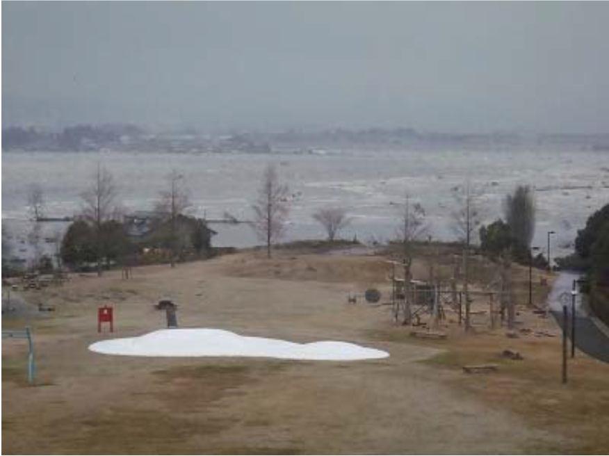
12 Figure 13 (Continued) Figure 14 Arahama Elementary School. 12


 (b) Figure")


13 Figure 15 Interview to Chief of Nursing Home in Arahama Figure 16 Left: Hazard Map; Right: Seawall (a) (b) Figure 17 (a) Staircase built for access to the surface of the Sendai-East expressway and (b) New tsunami memorial (13/3/2013) 13


14 9. Yuriage town, Natori city Yuriage area is located in Natori city, Miyagi. It is a former high-activity fishery port with only 7,000 residents. Yuriage is near the Natori River; therefore tsunami inundation ran up faster. There were many deaths reported here including firefighters on duty. 890 dead, 231 missing and 310 damaged roads were reported. Around 1,588 ha of agricultural area were damaged. Tsunami height was of 8 meters and 45min arrival. Figure 18 Left: Yuriage 2008; Right: Yuriage 2011 Figure 19 Left: Hiyoriyama; Right: Yuriage town view Figure 20 Left: Fish market; Right: Fishery port 14


15 Figure 21 Left: Hiyoriyama before (Google street view); Right: Hiyoriyama after (Panoramio) Figure 22 Left: An aerial view of Yuriage, the most devastated area in Natori city, in the direction from south to north. The Teizan Canal, cut over 400 years ago, is seen in the middle. The right side of the canal is Yuriage 6-chome, and the left side is Yuriage 7-chome; Right: Yuriage is a densely populated area. The nursing home Urayasu is seen in the front. After the tsunami attack, the area was flooded and the nursing home was isolated for 4 days. Most of the houses in the area in this photo were washed away. (Self Defense Force) Figure 23 Left: An aerial view of Yuriage in the direction from north to south. The floodgate at the bottom in the photo is the entry point from Natori river to the Teizan Canal. Many bodies and vehicles lie at the bottom of water in this area. Rescue divers have been in search and rescue work since March 19. Right: Yuriage Junior High School served as a temporary evacuation center. Many cars and fishing boats were swept into the school yard. (Self Defense Force) 15
; Right: About 3 m land elevation in Yuriage will be increased as shown in the model 10.")

.")


16 Figure 24 Left: Tsunami inundation mark on the pedestrian bridge that saved many lives in Yuriage (30/5/2012); Right: About 3 m land elevation in Yuriage will be increased as shown in the model 10. Sendai Airport, Natori city Sendai Airport is located 13.6 km southeast of Sendai city in Natori, Miyagi. It was built in 1940 by the Imperial Japanese Army, turned into national airport in 1957 and then upgraded to international airport in In 2011, the airport was first damaged by the earthquake and tsunami. Inundation reached up to some areas of the 2 nd level of passenger terminal (3.5m). All services were stopped at the moment and 1,300 people stranded in the terminal until March 13 th. It was reopened only for tsunami response flights on March 17 th. The US Air Force and Japan Self-Defense forces removed debris until the airport reopened to limited commercial traffic on April 13 th. Regular domestic flights resumed on July 25 th and most international flights on October Figure 25 Damages to Sendai Airport (Left: before [ Right: after) 16
 Figure 27 Left: Us Army; Right: Airport June, 2011 [AP/Kyodo News])")


17 Figure 26 Left: South to North; Right: North to South [ Figure 27 Left: Us Army; Right: Airport June, 2011 [AP/Kyodo News]) Figure 28 Left: Tsunami inundation mark in the Sendai airport (25/1/2012); Right: display of tsunami damage in the Sendai airport train station (25/1/2012) 11. Thousand years hope hill, Iwanuma city Iwanuma city was one of the cities that had a coastal pine tree forest along their coast linked from the northern part of Miyagi prefecture. However, the greenbelt was heavily damaged and the city has a plan to replant it again. Besides, they have an idea to construct an artificial hill which height varies from m using tsunami debris. The purpose of the hill is to use as a memorial park and evacuation place as an escape hill for a future tsunami called Hill of thousand years hope (Iwanuma city, 2011). This hill will also help with new seawall to reduce tsunami energy for the new populated area behind it. The town has a plan to use solar energy in a large scale to build an eco-compact city project. 17

 12.")


18 Iwanuma city Tsunami inundation limit Tsunami escape hill1 Tsunami escape hill2 Tsunami prevention road Tsunami evacuation route Tsunami prevention dike Figure 29 Reconstruction plan of Iwanuma city Figure 30 Cross section of the hill of thousand years hope Figure 31 Left: Experiment model of the thousand years hope hill (3/8/2012); Right: Tsunami inundation mark in Iwanuma city area (3/8/2012) 12. Sengan shrine, Iwanuma city There is a historical record showing that the word tsunami was first used after the 1611 Keicho Sanriku tsunami that caused a wide range of damage in Sendai plain areas. The area was controlled by the great lord Date Masamune. At that time, Masamune asked his samurais for fish who were then swept by the tsunami and could survived by getting struck on a pine tree under the Sengan mountain. Old Abukuma River was overflowed and disappeared after the town reconstruction. 18
 Sengan Mt.")


19 Sendai Castle Sengan Mt. Iwanuma Figure 32 Left: Samurais left Sendai castle to catch fish for Masamune. They were swept by the tsunami which dragged them to Sengan Mountain; Right: Story at that time (Tsuji, 2011) Sengan Mt. Old Abukuma Riv. Iwanuma Figure 33: Historical map in Sengan Mountain area showing location of the old Abukuma River and estimated inundation area by the 1611 tsunami is shown in blue (Ebina, 2011) Present Abukuma Riv. Sengan Mt. Iwanuma Present Abukuma Riv. Figure 34: Present map in Sengan Mountain area where the old Abukuma River was disappeared (Red line shows tsunami inundation limit of the 2011 tsunami). It can be noted that coast line at the time of 1611 tsunami was about 400 m more inland More information on our publications Suppasri, A., Shuto, N., Imamura, F., Koshimura, S., Mas, E. and Yalciner, A.C., Lessons learned from the 2011 Great East Japan tsunami: Performance of tsunami countermeasures, coastal buildings and tsunami evacuation in Japan, Pure and Applied Geophysics (published online) 19
20 Suppasri, A., Muhari, A., Ranasinghe, P., Mas, E., Shuto, N., Imamura, F. and Koshimura, S. (2012) Damage and reconstruction after the 2004 Indian Ocean tsunami and the 2011 Great East Japan tsunami, Journal of Natural Disaster Science, 34 (1), Suppasri, A., Koshimura, S., Imai, K., Mas, E., Gokon, H., Muhari, A. and Imamura, F. (2012) Damage characteristic and field survey of the 2011 Great East Japan tsunami in Miyagi prefecture, Coastal Engineering Journal, 54(1) Special Anniversary Issue on the 2011 Tohoku Earthquake Tsunami, References Abe, I. and Imamura, F. [2010] The 3 rd International Tsunami Field Symposium (ITFS), Sanriku field trip guidebook, 11 pp. Coastal Engineering Committee (JSCE) [2011] The 2011 Tohoku earthquake tsunami information, (accessed 28 May 2011). Ebina, Y. [2011] Corrections of the 1611 earthquake and tsunami, 1611 Keicho earthquake tsunami 400 years symposium, Tohoku university. Google Earth [2011] Iwanuma city (2011), Reconstruction plan home page (in Japanese) Japan Meteorological Agency (JMA) [2011] The 2011 off the Pacific coast of Tohoku earthquake, (accessed 12 June 2011) Miyagi Prefecture [2011] Earthquake damage information, (accessed 1 December 2011) Sawai, Y., Fujii, Y., Fujiwara, O., Kamataki, T., Komatsubara, J., Okamura, Y., Satake, K. and Shishikura, M. [2008] Marine incursions of the past 1500 years and evidence of tsunamis at Suijin-numa, a coastal lake facing the Japan Trench, The Holocene, 18 (4), Sendai city [2011] Press release document, (In Japanese) (accessed 17 August 2011) Statistics Bureau, Ministry of Internal Affairs and Communications [2011], Estimation of number of population and household in tsunami inundated area, (in Japanese) (accessed 25 April 2011) Sugawara, D. and Imamura, F. [2010] The 3 rd International Tsunami Field Symposium (ITFS), Sendai field trip guidebook, 21 pp. The 2011 Tohoku Earthquake Tsunami Joint Survey Group [2011] Nationwide Field Survey of the 2011 Off the Pacific Coast of Tohoku Earthquake Tsunami, Journal of Japan Society of Civil Engineers, Series B, Vol. 67 (1) pp Tsuji, Y. [2011] Generation of earthquake and tsunami of the 1611 Keicho event, 1611 Keicho earthquake tsunami 400 years symposium, Tohoku university. Tsunami Engineering Laboratory (TEL), Disaster Control Research Center (DCRC), Tohoku University [2011] Tsunami survey results, (accessed 8 April 2011) US Geological Survey (USGS) [2011] Magnitude 9.0 Near the east coast of Honshu, Japan, (accessed 20 March 2011). 20
Field Guide for the participants of the International Symposium on Earthquake & Tsunami Disaster Reduction. 16 March 2012
 Field Guide for the participants of the International Symposium on Earthquake & Tsunami Disaster Reduction Ishinomaki Onagawa Sendai Natori 16 March 2012 Tsunami struck Sendai Plain after one hour Tsunami
Minami-Sanriku town field trip (17 March 2013)
") Minami-Sanriku town field trip (7 March 23) By Anawat Suppasri, Abdul Muhari, Fumihiko Imamura, IRIDeS, Tohoku University. Background of tsunamis in Tohoku region There were three major tsunami events
Minami-Sanriku town field trip (7 March 23) By Anawat Suppasri, Abdul Muhari, Fumihiko Imamura, IRIDeS, Tohoku University. Background of tsunamis in Tohoku region There were three major tsunami events
REPORT OF STUDY TRIP (TOHOKU)
") INTERNATIONAL INSTITUTE OF SEISMOLOGY AND EARTHQUAKE ENGINEERING (IISEE) REPORT OF STUDY TRIP (TOHOKU) 14 18 November 2011 Prepared by: Nur Intan Irzwanee Nurashid T course (Malaysia) 5/12/2011 Day 1:
INTERNATIONAL INSTITUTE OF SEISMOLOGY AND EARTHQUAKE ENGINEERING (IISEE) REPORT OF STUDY TRIP (TOHOKU) 14 18 November 2011 Prepared by: Nur Intan Irzwanee Nurashid T course (Malaysia) 5/12/2011 Day 1:
REPORT OF STUDY TRIP (TOHOKU)
") INTERNATIONAL INSTITUTE OF SEISMOLOGY AND EARTHQUAKE ENGINEERING (IISEE) REPORT OF STUDY TRIP (TOHOKU) 14 18 November 2011 Prepared by: Dwi Hartanto T course (Indonesia) 0 DAY 1: NOVEMBER 14, 2011 On March
INTERNATIONAL INSTITUTE OF SEISMOLOGY AND EARTHQUAKE ENGINEERING (IISEE) REPORT OF STUDY TRIP (TOHOKU) 14 18 November 2011 Prepared by: Dwi Hartanto T course (Indonesia) 0 DAY 1: NOVEMBER 14, 2011 On March
Damage and reconstruction after the 2004 Indian Ocean tsunami and the 2011 Great East Japan tsunami
 Journal of Natural Disaster Science, Volume 34, Number 1, 2012, pp19-39 Damage and reconstruction after the 2004 Indian Ocean tsunami and the 2011 Great East Japan tsunami Anawat SUPPASRI* Abdul MUHARI*
REPORT OF STUDY TRIP (TOHOKU)
") INTERNATIONAL INSTITUTE OF SEISMOLOGY AND EARTHQUAKE ENGINEERING (IISEE) REPORT OF STUDY TRIP (TOHOKU) 10-14 JULY 2011 PREPARED BY: MAZNI BINTI AZIS MALAYSIA SUBMISSION DATE: JULY 29, 2011 TSUNAMI DISASTER
INTERNATIONAL INSTITUTE OF SEISMOLOGY AND EARTHQUAKE ENGINEERING (IISEE) REPORT OF STUDY TRIP (TOHOKU) 10-14 JULY 2011 PREPARED BY: MAZNI BINTI AZIS MALAYSIA SUBMISSION DATE: JULY 29, 2011 TSUNAMI DISASTER
DAMAGE DUE TO THE 2011 TOHOKU EARTHQUAKE TSUNAMI AND ITS LESSONS FOR FUTURE MITIGATION
 Proceedings of the International Symposium on Engineering Lessons Learned from the 2011 Great East Japan Earthquake, March 1-4, 2012, Tokyo, Japan DAMAGE DUE TO THE 2011 TOHOKU EARTHQUAKE TSUNAMI AND ITS
Population Movement in the Tohoku Region after the Great East Japan Earthquake Disaster
 83 Population Movement in the Tohoku Region after the Great East Japan Earthquake Disaster Takashi ABE Abstract This paper clarifies the demographic change in the Tohoku Region after the Great East Japan
Urgent Surveys for Evacuation and Measures from Unexpected Large Tsunami
 J-RAPID Symposium, Sendai, March 6-7,2013 Japan Indonesia Joint Research J-RAPID Urgent Surveys for Evacuation and Measures from Unexpected Large Tsunami PIs: Kenji Satake, ERI the University of Tokyo
Restoration and Challenge of Sendai Towards a Disaster-Resilient and Environmentally-Friendly City
 City of Sendai Restoration and Challenge of Sendai Towards a Disaster-Resilient and Environmentally-Friendly City Akira TAKAHASHI akira_takahashi_a@city.sendai.jp Director, Disaster-Resilient and Environmentally-Friendly
Tsunami Impacting Eastern Japan and Preparedness for Extraordinary Natural Disaster. Takehiko Fujita
 May 25, 2011 Tsunami Impacting Eastern Japan and Preparedness for Extraordinary Natural Disaster Takehiko Fujita Acting President Port and Airport Research Institute, Japan Contents 1. Outline of the earthquake
TSUNAMI DAMAGE IN PORTS BY THE 2011 OFF PACIFIC COAST OF TOHOKU EARTHQUAKE
 Proceedings of the International Symposium on Engineering Lessons Learned from the 2011 Great East Japan Earthquake, March 1-4, 2012, Tokyo, Japan TSUNAMI DAMAGE IN PORTS BY THE 2011 OFF PACIFIC COAST
Executive Summary of Urgent Field Survey of Earthquake and Tsunami Disasters by the 2011 off the Pacific coast of Tohoku Earthquake
 March 25, 2011 Executive Summary of Urgent Field Survey of Earthquake and Tsunami Disasters by the 2011 off the Pacific coast of Tohoku Earthquake Port and Airport Research Institute (PARI) has accomplished
Disaster Committee, Tohoku Chapter Mr. Mitsuo Ikami, Taiheiyo Cement Co. (Translated by Shunsuke Otani, University of Tokyo)
") Tohoku Chapter, Architectural Institute of Japan Reconnaissance Report (18) on Miyako City and Kamaishi City The 2011 off the Pacific Coast of Tohoku Earthquake Released on April 15, 2011 Disaster Committee,
Tohoku Chapter, Architectural Institute of Japan Reconnaissance Report (18) on Miyako City and Kamaishi City The 2011 off the Pacific Coast of Tohoku Earthquake Released on April 15, 2011 Disaster Committee,
2011/EPWG/WKSP2/003 Earthquake and Tsunami Disaster in Japan Experience and Lessons
 2011/EPWG/WKSP2/003 Earthquake and Tsunami Disaster in Japan Experience and Lessons Submitted by: Asian Disaster Reduction Center (ADRC) Workshop on Facing Abnormal Flood Disaster: New Vision for APEC
REPORT OF STUDY TRIP (Niigata & Miyagi Prefectures)
") INTERNATIONAL INSTITUTE OF SEISMOLOGY AND EARTHQUAKE ENGINEERING (IISEE) REPORT OF STUDY TRIP (Niigata & Miyagi Prefectures) 14 17 November 2011 Prepared by: D.Mungunsuren S course (Mongolia) INTRODUCTION
INTERNATIONAL INSTITUTE OF SEISMOLOGY AND EARTHQUAKE ENGINEERING (IISEE) REPORT OF STUDY TRIP (Niigata & Miyagi Prefectures) 14 17 November 2011 Prepared by: D.Mungunsuren S course (Mongolia) INTRODUCTION
GREAT EARTHQUAKE DISASTER NILIM, JAPAN
 EAST- JAPAN GREAT EARTHQUAKE DISASTER 11 MARCH in 2011 NILIM, JAPAN CONTENTS 1. Outline of the EARTHQUAKE DISASTER 2. History of EARTHQUAKE/TSUNAMI occurred in Japan 3. Disaster Prevention Policy and Strategy
Earthquake. 2. MLIT s emergency response to the Great East Japan Earthquake. 3. Recent policy changes regarding tsunami
 1. Damages caused by the Great East Japan Earthquake 2. MLIT s emergency response to the Great East Japan Earthquake 3. Recent policy changes regarding tsunami disaster countermeasures 10 Basic Principles
The Event: once in 1,000 years
 East Japan Earthquake and Tsunami: Post disaster Issues and Challenges http://www.dailymail.co.uk Rajib Shaw http://www.iedm.ges.kyoto u.ac.jp/ t / http://www.dailymail.co.uk The Event: once in 1,000 years
EO Contribution to Recovery Activities - A case study on the experience of the Great East Japan Earthquake -
 EO Contribution to Recovery Activities - A case study on the experience of the Great East Japan Earthquake - Michio Ito (Mr.) ito.michio@jaxa.jp Space Applications and Operation Center JAXA Purpose of
Post tsunami Recovery of Port and Harbor areas in Japan from the 2011 Great East Japan Earthquake Tsunami
 Date : 18 Nov., 2015 Venue : Furama Ballroom 1 SESSION 1 : A Decade of Partnerships in Sustainable Development of the Seas of East Asia: Synergies and Achievements WORKSHOP 1.1 : Managing Risks in Climate
Tsunami Evacuation Process and Human Loss Distribution in the 2011 Great East Japan Earthquake - A Case Study of Natori City, Miyagi Prefecture -
 Tsunami Evacuation Process and Human Loss Distribution in the 2011 Great East Japan Earthquake - A Case Study of Natori City, Miyagi Prefecture - H. Murakami, K. Takimoto Graduate School of Science and
The 2011 off the Pacific coast of Tohoku Earthquake. (immediate version)
") 2011.3.15 The 2011 off the Pacific coast of Tohoku Earthquake SituationReport 1 (immediate version) SEEDS Asia Map of Seismic Intensity Tohoku Earthquake of 14:46(JST), 11 March 2011 Source : Japan Meteorological
2011.3.15 The 2011 off the Pacific coast of Tohoku Earthquake SituationReport 1 (immediate version) SEEDS Asia Map of Seismic Intensity Tohoku Earthquake of 14:46(JST), 11 March 2011 Source : Japan Meteorological
The Great East Japan Earthquake Study Tour. 27. Feb.2018
 The Great East Japan Earthquake Study Tour 27. Feb.2018 Overview of the Great East Japan earthquake Kamaishi The Great East Japan earthquake occured: 2011.3.11 14:46 M9.0 dead: 19,575 missing: 2,577 injured:
KNOWLEDGE NOTE 1-3. Hydro-meteorological Disasters Associated with Tsunamis and Earthquakes. CLUSTER 1: Structural Measures
 Public Disclosure Authorized Public Disclosure Authorized Public Disclosure Authorized Public Disclosure Authorized KNOWLEDGE NOTE 1-3 CLUSTER 1: Structural Measures Hydro-meteorological Disasters Associated
MARCH 2011, TSUNAMI DISASTER IN JAPAN
 MARCH 2011, TSUNAMI DISASTER IN JAPAN Dr. Neelima Satyam D 1 and Dr. D V Reddy 2 1 Assistant Professor Earthquake Engineering Research Centre International Institute of Information Technology Hyderabad
Photo 1: Tsunami wave flowed over 4-m high breakwater. Photo 2: No damage was observed in these timber houses.
 Tohoku Chapter, Architectural Institute of Japan Reconnaissance Report (16) on Mangoku-ura and Onagawa-cho The 2011 off the Pacific Coast of Tohoku Earthquake Released on April 15, 2011 Disaster Committee,
Japan Earthquake and Tsunami: a view from satellite data
 Università degli studi di Roma Tor Vergata Corso di Telerilevamento e Cartografia Anno accademico 2012/2013 Japan Earthquake and Tsunami: a view from satellite data Dr. Matteo Picchiani picchiani@disp.uniroma2.it
References for Tohoku Trip June Contents
 References for Tohoku Trip 28-29 June 2012 Contents 1. Inundated Area Ishinomaki City 01 Onagawa Town 03 Minamisanriku Town 04 Kesennuma City 05 2. Maps before and after damage Minamisanriku Town 06 Kesennuma
Great East Japan Earthquake Kimiaki Nagashima
 Great East Japan Earthquake Kimiaki Nagashima Japan Water Works Association 12.05.2011 Great East Japan earthquake 1 earthquake 2 Tsunamis 3Floods 4fires 5Nuclear disasters From the daily yomiuri Mar 12,2011
 Quaternary Research for Extreme Natural Hazards: Lessons from March 11, 2011 Earthquake and Tsunami Koji Okumura (Hiroshima University) March 11, 2011 Tohoku Earthquake and Tsunamis fatalities missing
OUTLINE. About Sendai City Basic Plan for Disaster Management. of Sendai city 3 Actions for Build Back Better
 OUTLINE 1 2 About Sendai City Basic Plan for Disaster Management of Sendai city 3 Actions for Build Back Better About Sendai City Tsunami Land Slide Flooded Areas Floor collapse Major Disaster Affected
Human Casualty and Behavior due to the Great East Japan Earthquake in 2011
 Human Casualty and Behavior due to the Great East Japan Earthquake in 2011 M. Miyano, E. Ikuta, T. Takahashi, T. Doi, S. Ito, M. Omichi & T. Shigaki Osaka City University, Japan R. Nobuhara Kyoto University
Tsunami Survey Results in the NPS and Reproduction Analysis Using Tsunami Inversion
 Technical Workshop on the Accident of TEPCO s Fukushima Dai-ichi NPS Tsunami Survey Results in the NPS and Reproduction Analysis Using Tsunami Inversion July 24, 2012 Tomoyuki Tani Agenda 1. Overview of
IOC/UNESCO Bulletin No. 8 As of 23 March 2011
 IOC/UNESCO Bulletin No. 8 As of 23 March 2011 Casualties by the Earthquake and Tsunami As of 06:00z 23 Mar 2011 The National Police Agency Dead: 9,452 Missing: 14,715 Road destruction: 1,749 Bridge destruction:
Tohoku Pacific Ocean Earthquake: Current Status and Restoration Plan
 Tohoku Pacific Ocean Earthquake: Current Status and Restoration Plan NTT DOCOMO, INC. March 30, 2011 Damage to Base Stations & Restoration Measures 788 base stations requiring inspection as of March 22
Path forward for reconstruction after the disaster
 Path forward for reconstruction after the 3.11 2011 disaster 2.16 2013 1- Immediate Impact of the 3.11 Disaster Earthquake Magnitude: 9.0 Casualties: Dead : over 15,800 Missing: over 2,700 Injured: over
JR East: Earthquake Measures
 JR East: Earthquake Measures and their effectiveness 11 July 2012, Parallel sessions: Operation 1 (Risk analysis) Content Part 1 Outline of JR East and our risk evaluation Part 2 Two earthquakes that occurred
THE DESIGN AND IMPLEMENTATION OF A PRACTICAL TSUNAMI EVACUATION DRILL
 THE DESIGN AND IMPLEMENTATION OF A PRACTICAL TSUNAMI EVACUATION DRILL K. TERUMOTO Wakayama University, Japan SUMMARY: Tsunami evacuation measures are now an urgent issue in Japanese coastal area. One of
REPORT OF STUDY TRIP (Niigata & Miyagi Prefectures)
") INTERNATIONAL INSTITUTE OF SEISMOLOGY AND EARTHQUAKE ENGINEERING (IISEE) REPORT OF STUDY TRIP (Niigata & Miyagi Prefectures) 14 17 November 2011 Prepared by: Biana Rahayu Wulandari S course (Indonesia)
INTERNATIONAL INSTITUTE OF SEISMOLOGY AND EARTHQUAKE ENGINEERING (IISEE) REPORT OF STUDY TRIP (Niigata & Miyagi Prefectures) 14 17 November 2011 Prepared by: Biana Rahayu Wulandari S course (Indonesia)
In depth damage report by affected cities
 The Great Eastern Japan Earthquake (GLIDE: EQ-2011-000028-JPN) 2011.04.28 In depth damage report by affected cities SEEDS Asia Table of Contents I: Overview II: The Earthquake and Tsunami: Their Impact
Tsunami Impacting Eastern Japan and Preparedness for Extraordinary Natural Disaster. Takehiko Fujita
 February 22, 2012 Tsunami Impacting Eastern Japan and Preparedness for Extraordinary Natural Disaster Takehiko Fujita Executive Director Port and Airport Research Institute, Japan Contents 1. Outline of
Higashi-Matsushima -- Disaster Recovery and FutureCity
 Higashi-Matsushima -- Disaster Recovery and FutureCity Overview of Higashi-Matsushima [Location and Climate] Higashi-Matsushima is located to the northeast of Sendai, the capital of Miyagi Prefecture.
The Planning Process of the Restoration from the Great East Japan. Earthquake for Resilient City and Region in Miyagi-Pref.
 Proceedings of International Symposium on Planning 2013 The Planning Process of the Restoration from the Great East Japan Earthquake for Resilient and Region in Miyagi-Pref. Mikiko Ishikawa* Abstract Two
Report on Field Survey of Solomon Islands Earthquake Tsunami in April 2007
 Report on Field Survey of Solomon Islands Earthquake Tsunami in April 2007 by Takashi Tomita 1, Taro Arikawa 2, Daisuke Tatsumi 3, Kazuhiko Honda 3, Hiroshi Higashino 4 Kazuya Watabnabe 4, and Shigeo Takahashi
KNOWLEDGE NOTE 2-6. Evacuation. CLUSTER 2: Nonstructural Measures. Public Disclosure Authorized. Public Disclosure Authorized
 Public Disclosure Authorized Public Disclosure Authorized Public Disclosure Authorized Public Disclosure Authorized KNOWLEDGE NOTE 2-6 CLUSTER 2: Nonstructural Measures 1 Prepared by Mikio Ishiwatari,
East Japan Disaster- Preliminary Report
 East Japan Disaster- Preliminary Report NEWS LETTER 2011 Association of Japanese Consulting Engineers (AJCE) 1. Introduction At 14:46 March 11, 2011, It started with slight shakes. Japan has a lot of earthquakes.
Recent Development of Urban Disaster Mitigation in Japan with a Focus on Tsunami
 Recent Development of Urban Disaster Mitigation in Japan with a Focus on Tsunami Nozomu Kiuchi Head of the Urban Planning Division Shuichi Takeya Head of the Urban Disaster Mitigation Division National
the high fatalities inflicted by the earthquake
 2011.10.25 The 2011 off the Pacific Coast of Tohoku earthquake Interviewing insights regarding the high fatalities inflicted by the earthquake Masataka Ando 1, Mizuho Ishida 2, Yoshinari Hayashi 3 and
The 2011 off the Pacific coast of Tohoku Earthquake. Situation Report 4. SEEDS Asia
 2011.3.18 The 2011 off the Pacific coast of Tohoku Earthquake Situation Report 4 SEEDS Asia Table of contents - Overview - Situation by Affected Prefectures - Relief Operation by Japanese Humanitarian
Mitigation of Tsunami Disasters in Ports
 PIANC MARCOM Seminar in Japan September 13, 2013 PIANC WG 53 Mitigation of Tsunami Disaster in Ports Lessons learnt from the Great East Japan Earthquake Mitigation of Tsunami Disasters in Ports Lessons
Damage/Needs Assessment In the Affected Area of The 2011 off the Pacific Coast of Tohoku Earthquake and Tsunami
 Damage/Needs Assessment In the Affected Area of The 2011 off the Pacific Coast of Tohoku Earthquake and Tsunami 11 th of April 2011 SEEDS Asia, OYO International Corporation and Kyoto University About
KNOWLEDGE NOTE 4-1. Infrastructure Rehabilitation. CLUSTER 4: Recovery Planning. Public Disclosure Authorized. Public Disclosure Authorized
 KNOWLEDGE NOTE 4-1 CLUSTER 4: Recovery Planning Public Disclosure Authorized Public Disclosure Authorized Public Disclosure Authorized Public Disclosure Authorized 1 Prepared by Junko Sagara, CTI Engineering,
Keiichi Inoue Vice-President of PIARC. Exchange knowledges and techniques on roads and road transportation
 Keiichi Inoue Vice-President of PIARC 11 March, 2011 14:46(JST) 100km Disaster By TUNAMI By Earthquake Distribution of seismic intensity March 11 th, 2011 14:46 (JST) The earthquake caused extensive damages
The 2011 off the Pacific coast of Tohoku Earthquake. Situation Report 5. SEEDS Asia
 2011.3.20 The 2011 off the Pacific coast of Tohoku Earthquake Situation Report 5 SEEDS Asia Table of contents - Overview - Situation by Affected Prefectures - Relief Operation by Japanese Humanitarian
Injury Estimation for Foreseen Earthquakes in an Aging Society and Its Application to Sendai City, Japan
 Journal of Natural Disaster Science, Volume 33, Number 1, 2012, pp1-10 Injury Estimation for Foreseen Earthquakes in an Aging Society and Its Application to Sendai City, Japan Takeshi SATO* Masatoshi OBA**
Presentation to Australia Japan Society New South Wales Branch 16 March 2016
 Presentation to Australia Japan Society New South Wales Branch 16 March 2016 JAPAN EARTHQUAKE AND TSUNAMI FIVE YEARS ON REFLECTIONS ON VOLUNTEERING John Black Emeritus Professor of Transport Engineering
Japan earthquake and tsunami Situation Report No March 2011 As of 1830 hrs Manila Time
 Japan earthquake and tsunami Situation Report No. 03 12 March 2011 As of 1830 hrs Manila Time SITUATION SUMMARY An 8.8 earthquake occurred at 05.46.23 UTC on 11 Mar 2011 in Japan, hitting the northeast
lessons we should learn from the Great East Japan Disaster?
 What lessons we should learn from the Great East Japan Disaster? The Univerisity of Tokyo, Science Council of Japan April 2 nd, 2012 1 Organization of Science Council of Japan President Vice-President
IMPORTANCE OF THE INHERITED MEMORIES OF GREAT TSUNAMI DISASTERS IN NATURAL DISASTER REDUCTION
 Proceedings of the International Symposium on Engineering Lessons Learned from the 2011 Great East Japan Earthquake, March 1-4, 2012, Tokyo, Japan IMPORTANCE OF THE INHERITED MEMORIES OF GREAT TSUNAMI
Table Major analysis products provided by JAXA
 Report on JAXA s Response to the Great East Japan Earthquake - Assistance using earth observation satellites and communication satellites - 2.1.5 Product provision and utilization by users for disaster
Low-carbon and resilient energy supply systems using regional/local resources HIGASHIMATSUSHIMACITY MAYOR HIDEO ABE
 Low-carbon and resilient energy supply systems using regional/local resources 2016.5.15 HIGASHIMATSUSHIMACITY MAYOR HIDEO ABE 1 Overview of Higashimatsushima [Location] Higashimatsushima City is located
Transport and Travel in Japan
 Transport and Travel in Japan Singapore Jakarta: 900km Singapore KL : 300km Yellow Circle: Area within a radius of 30 kilometers from Fukushima Daiichi Nuclear Plant. 22 Fukushima Dai-ichi Atmospheric
Great East Japan Earthquake and Tsunami, Fukushima Daiichi NPP Accident (1/5)
") Great East Japan Earthquake and Tsunami, Accident (1/5) < About Great East Japan Earthquake and Tsunami > Date and Time: March 11, 2011 14:46 JST Epicenter: Off the Sanriku coast (38 6.2 N, 142 52 E) Depth
Great East Japan Earthquake and Tsunami, Accident (1/5) < About Great East Japan Earthquake and Tsunami > Date and Time: March 11, 2011 14:46 JST Epicenter: Off the Sanriku coast (38 6.2 N, 142 52 E) Depth
Dear Participants at the meeting On the subject of Earthquake Resilience in Metro Manila. Greetings from Hyogo, Japan Greetings from IRP
 Dear Participants at the meeting On the subject of Earthquake Resilience in Metro Manila Greetings from Hyogo, Japan Greetings from IRP Kobe Earthquake in Jan. 1995 The Hanshin Awaji Earthquake 17.1.1995,
The Hokkaido Earthquake: a (very) preliminary analysis revision 1
 preliminary analysis revision 1") The Hokkaido Earthquake: a (very) preliminary analysis revision 1 September 06, 2018, 03:08 JST Woody Epstein, ARS Where it happened Map of Hokkaido indicating JMA Intensities (Shindo) A First report from
The Hokkaido Earthquake: a (very) preliminary analysis revision 1 September 06, 2018, 03:08 JST Woody Epstein, ARS Where it happened Map of Hokkaido indicating JMA Intensities (Shindo) A First report from
The 2011 off the Pacific coast of Tohoku Earthquake
 The 2011 off the Pacific coast of Tohoku Earthquake (GLIDE: EQ-2011-000028-JPN) Situation Report 8 2011.03.24 Source: "Reuters/SALY SONG, courtesy Trust.org - AlertNet" SEEDS Asia www.seedsasia.org Table
The 2011 off the Pacific coast of Tohoku Earthquake. Situation Report 3. SEEDS Asia
 2011.3.17 The 2011 off the Pacific coast of Tohoku Earthquake Situation Report 3 SEEDS Asia Overview With the massive earthquake and the following tsunamis happened on 11 March 2011 (14:46 JST), the death
Japan opts for massive, costly sea wall to fend off tsunamis 22 March 2015, byelaine Kurtenbach
 Japan opts for massive, costly sea wall to fend off tsunamis 22 March 2015, byelaine Kurtenbach "The reality is that it looks like the wall of a jail," said Musashi, 46, who lived on the seaside before
P. Gaubert, A. Funayama and H. Moriya (School of Engineering, Tohoku University)
") P. Gaubert, A. Funayama and H. Moriya (School of Engineering, Tohoku University) 1 Multi-hazards - Mega Earthquake, Mega Tsunami and Nuclear Power Plant Accident When did it happen? March 11, 2011, at
P. Gaubert, A. Funayama and H. Moriya (School of Engineering, Tohoku University) 1 Multi-hazards - Mega Earthquake, Mega Tsunami and Nuclear Power Plant Accident When did it happen? March 11, 2011, at
Great East Japan Earthquake and Tsunami
 Great East Japan Earthquake and Tsunami Kuniyoshi Takeuchi International Centre for Water Hazard and Risk Management under the auspices of UNESCO (ICHARM) Public Works Research Institute (PWRI) Tsukuba,
Ganbarou! TOHOKU. to the Great East Japan Earthquake
 Ganbarou! TOHOKU Response of Tohoku Regional Bureau, MLIT, espo se o o o u eg o a u eau,, to the Great East Japan Earthquake Outline of the Great East Japan Earthquake Date/Time: March 11 14:46, 46 2011
THE 1960 CHILEAN TSUNAMI
 THE 1960 CHILEAN TSUNAMI KIYOSHI HORIKAWA Tsunami Workshop, Dec 26-28, 2006, Hilo, Hawaii HORIKAWA, K. 1/29 Initiation of Earthquake Observation (around 1872) Meiji Sanriku Tsunami (1896) Great Kanto Earthquake
Japan & JICA s experiences, Risk Governance and/for Resilience and Risk Reduction =The 2nd Arab Conference on DRR=
 Japan & JICA s experiences, Risk Governance and/for Resilience and Risk Reduction =The 2nd Arab Conference on DRR= TAKEYA Kimio Senior Advisor, JICA takeya.kimio@jica.go.jp Japanese Experiences 1 Why Japan
Tsunami Warning in Japan, and Tsunami Advisory for Northwest Pacific and Indian Ocean regions Mitsuyuki Hoshiba
 Tsunami Warning in Japan, and Tsunami Advisory for Northwest Pacific and Indian Ocean regions Mitsuyuki Hoshiba Japan Meteorological Agency (JMA) Contents Tsunami Warning / Advisory in Japan International
Effectiveness of Electrical Safety Management Service proven by the Great East Japan Earthquake
 Effectiveness of Electrical Safety Management Service proven by the Great East Japan Earthquake Seiji Watanabe Tohoku Electrical Safety Inspection Association 1 Fédération Information Internationale pour
Damage and Provision of Aid of Water Supply in Disaster-hit Areas, the Great East Japan Earthquake and Tsunami
 Damage and Provision of Aid of Water Supply in Disaster-hit Areas, the Great East Japan Earthquake and Tsunami By Research and Publication Department, JAPAN WATER RESEARCH CENTER () Updated Wednesday March
Figure Pre- and post-disaster satellite topographical maps
 2.1.3 Image analysis by JAXA JAXA conducted ongoing emergency observations using Daichi in the wake of the Great East Japan Earthquake, releasing reporting of its analysis of eastern Japan and Hokkaido
The 2011 off the Pacific coast of Tohoku Earthquake. Situation Report 6. SEEDS Asia
 2011.3.21 The 2011 off the Pacific coast of Tohoku Earthquake Situation Report 6 SEEDS Asia Table of contents - Overview - Situation by Affected Prefectures - Relief Operation by Japanese Humanitarian
RESTORATIONS AND SYSTEM INTERACTIONS OF LIFELINES IN THE GREAT EAST JAPAN EARTHQUAKE DISASTER, 2011
 Proceedings of the International Symposium on Engineering Lessons Learned from the 211 Great East Japan Earthquake, March 1-4, 212, Tokyo, Japan RESTORATIONS AND SYSTEM INTERACTIONS OF LIFELINES IN THE
Typhoon Isewan and Its Lessons
 Typhoon Isewan and Its Lessons March 21, 2006 Kenji SUZUKI Japan Water Forum In 1959, Typhoon Isewan hit Central Japan and caused the worst damage, due to high tides and floods. Nagoya Typhoon Isewan courses
Photos courtesy of the Japanese Ministry of Foreign Affairs: Flooding at Sendai International Airport
 Dear Friends, I. Sendai International Airport On March 11 th Japan was struck by a three-fold disaster causing the loss of nearly 20,000 lives. In the following days and weeks, 19,703 members of the US
Role of Railways in Building Resilient Against Natural Disaster-Lessons from Japan
 Role of Railways in Building Resilient Against Natural Disaster-Lessons from Japan February 27, 2018 Yoshitaka Motoda Professor Emeritus Iwate Prefectural University Japan Contents Introduction Great East
POLICY ANALYSIS ON BUILDING REGULATIONS AND THE RECOVERY OF EARTHQUAKE / TSUNAMI AFFECTED AREAS
 Proceedings of the International Symposium on Engineering Lessons Learned from the 211 Great East Japan Earthquake, March 1-4, 212, Tokyo, Japan POLICY ANALYSIS ON BUILDING REGULATIONS AND THE RECOVERY
Characteristics of damage to transportation facilities induced by the ground shaking and the tsunami of the 2011 East Japan mega earthquake
 Characteristics of damage to transportation facilities induced by the ground shaking and the tsunami of the 2011 East Japan mega earthquake Ö. Aydan, Tokai University, Ocean Research Institute, Shizuoka,
Japan s Current Status and Challenges Towards Recovery
 Japan s Current Status and Challenges Towards Recovery June 22, 2011 Hiroshi Inomata Consul General of Japan in San Francisco 1. Japan Faces an Unprecedented Challenge (Enormous Earthquake, Tsunamis and
Taisei MORISHITA, Hiroaki SAITO and Shin TANI Hydrographic and Oceanographic Department (JHOD) Japan Coast Guard
 Japan Coast Guard") Taisei MORISHITA, Hiroaki SAITO and Shin TANI Hydrographic and Oceanographic Department (JHOD) Japan Coast Guard 1. Earthquake and Tsunami (review) 2. JHOD s Response Activities (overview) 3. Hydrographic
Taisei MORISHITA, Hiroaki SAITO and Shin TANI Hydrographic and Oceanographic Department (JHOD) Japan Coast Guard 1. Earthquake and Tsunami (review) 2. JHOD s Response Activities (overview) 3. Hydrographic
REGENERATION. February 21 st, 2012 Takashi ONISHI Professor, the University of Tokyo President, Science Council of Japan
 REGENERATION fromthe East Japan Great Earthquake February 21 st, 2012 Takashi ONISHI Professor, the University of Tokyo President, Science Council of Japan Gratitude and Contents Thanks for the help hl
Proposal of constructing new tsunami shelter buildings at Mimase in Kochi City
 Proposal of constructing new tsunami shelter buildings at Mimase in Kochi City Hiroyuki KITAMOTO Mimasaka University, Tsuyama, Japan Michio MIYANO Osaka City University, Osaka, Japan Sayumi HAGINO Miyajidenki
Thanks to the efforts of so many people and their support including that of international society, reconstruction is moving steadily ahead.
 Minister Yoshino s Keynote Speech at the Luncheon Plenary of the U.S.-Japan Council Annual Conference Reconstruction from the Great East Japan Earthquake (November 13, 2017, Washington DC) Ladies and gentlemen,
Chapter 10. Damage to Ports and Coastal Facilities
 Chapter 10 Damage to Ports and Coastal Facilities 10.1 Area Investigated Tsunami induced heavy damage to ports and coastal facilities along the west and north coast of Sumatra Island. Figure 10.1 shows
Proposing/Implementing Key Measures for Industrial Recovery from the Great East Japan Earthquake
 Global Conference on the International Network of Disaster Studies in Iwate, Japan "Iwate Conference" Proposing/Implementing Key Measures for Industrial Recovery from the Great East Japan Earthquake 2018.07.18
Scenario Analysis of Mega Earthquake and Tsunami in Central Japan
 Scenario Analysis of Mega Earthquake and Tsunami in Central Japan IRDR International Conference, Beijing 1 Nov, 2011 Naoki Fujiwara CTI Engineering Co., Ltd. Japan ICHARM International Centre for Water
Japan Academic Network for Disaster Reduction (JANET-DR) and interdisciplinary collaboration. Science Council of Japan
 and interdisciplinary collaboration. Science Council of Japan") Japan Academic Network for Disaster Reduction (JANET-DR) and interdisciplinary collaboration Members of SCJ and 56 academic societies proceed JANET-DR which covers social sciences, life sciences, natural
Japan Academic Network for Disaster Reduction (JANET-DR) and interdisciplinary collaboration Members of SCJ and 56 academic societies proceed JANET-DR which covers social sciences, life sciences, natural
ASSEMBLY 39TH SESSION
 International Civil Aviation Organization WORKING PAPER 30/8/16 ASSEMBLY 39TH SESSION EXECUTIVE COMMITTEE Agenda Item 28: No Country Left Behind Initiative QUICK RESPONSE AFTER EARTHQUAKE IN KUMAMOTO AIRPORT
The 2011 off the Pacific coast of Tohoku Earthquake
 The 2011 off the Pacific coast of Tohoku Earthquake Situation Report 9 2011.03.27 Source: "Reuters/ALY SONG, courtesy Trust.org - AlertNet" SEEDS Asia www.seedsasia.org Table of Contents I. Overview II.
Great East Japan Disaster: Tsunami Study
 Great East Japan Disaster: Tsunami Study (Survey Results) 9 September, 2011 Weathernews Inc., Japan 1 GREAT EAST JAPAN DISASTER SURVEY: TSUNAMI Weathernews wishes to offer our deepest sympathy to all the
Disaster management planning against large-scale earthquakes and tsunamis in Japan
 ver. 8 ( 2018.3.13 ) Disaster management planning against large-scale earthquakes and tsunamis in Japan Disaster Management Bureau, Cabinet Office of Japan 19 March, 2018 Anticipated large-scale earthquakes
Sachiura Project to save lives from Tsunamis
 Sachiura Project to save lives from Tsunamis Autamn 2014 ー Development timeline of Inochiyama of the Heisei era ー This is to report on how residents in the southern area of Asaba (Sachiura) undertook actions
Current Status of Reconstruction and Challenges
 Current Status of Reconstruction and Challenges Reconstruction progress of the six years and the policies ahead 1. Providing Health and Living Support 2. Restoration of Towns and Housings 3. Reviving Industry