Parker & Lincoln Development, LLC
|
|
|
- Terence Tucker
- 5 years ago
- Views:
Transcription

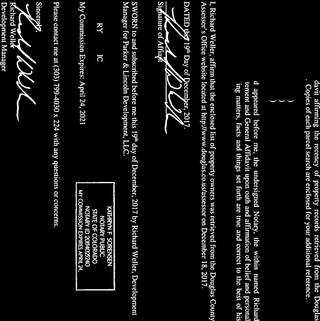
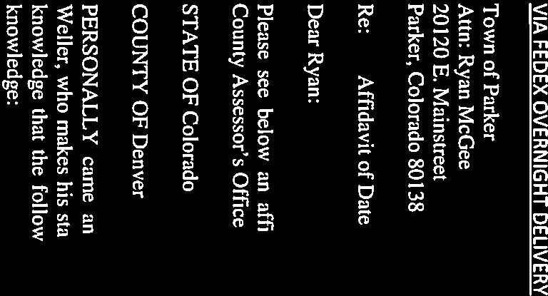
1 Parker & Lincoln Development, LLC 4643 S. Ulster Street, Suite 240 Denver, Colorado (303) VIA FEDEX OVERNIGHT DELIVERY December 19, 2017 Town of Parker Attn: Ryan McGee E. Mainstreet Parker, Colorado RE: Notice of Public Hearings Minor Development Plat Amendment Request SUB Dear Ryan: Please be advised that on December 19, 2017 the undersigned issued via first-class mail a Notice of Public Hearings to the owners of the properties abutting the parcels contemplated in the above referenced minor development plat amendment request, pursuant to and in accordance with (c) of the Town of Parker Municipal Code (Public Notice Procedures). Enclosed are the following for your records: 1. Notice of Public Hearings; 2. List of property owners to whom the Notice was sent; 3. Affidavit affirming recency of property records from which owner information was gathered; 4. Copies of Parcel Search Records retrieved from the Douglas County Assessor s website on December 18, Should you have any questions, please feel free to contact the undersigned. Sincerely, PARKER & LINCOLN DEVELOPMENT, LLC, a Colorado limited liability company By: Jarrett Armstrong Manager JMA/ks Enclosures: Exhibit A: Notice of Public Hearings Exhibit B: Property Owners Mailing List Affidavit with Parcel Search Record an Armstrong Capital Development company

2 EXHIBIT A NOTICE OF PUBLIC HEARINGS Parker Keystone Minor Development - Parker Heights Subdivision Minor Development Plat Amendment Request SUB Notice is hereby given that the Planning Commission and Town Council shall hold public hearings concerning a Minor Development Plat Amendment, located on the property described in Exhibit A and generally located at the southeast corner of CO Hwy 83 (S. Parker Road) and Lincoln Avenue, pursuant to the Town of Parker Land Development Ordinance. The public hearings are to be held before the Planning Commission on January 11, 2018 at 7:00 PM., or as soon as possible thereafter, followed by the Town Council on February 5, 2018, at 7:00 P.M., or as soon as possible thereafter. The public hearings shall be held in the Council Chambers located in the Parker Town Hall, E. Mainstreet, Parker, Colorado, or at such other time or place in the event this hearing is adjourned. Further information is available through the Town Planning Department at (303) Proposed Land Use ALL INTERESTED PERSONS MAY ATTEND A proposed development of several adjacent commercial lots located on the southeast corner of CO Hwy 83 (S. Parker Road) and Lincoln Avenue in Parker, Colorado. The purpose of the Minor Development Plat amendment is to replat Lots 1 and 2 Parker Keystone Minor Development Amendment No. 1 and Lot 2, Block 1 Parker Heights Filing No 1, incorporating both into a single plat with two commercial lots. The project will result in an enhanced visual appearance that will enliven the streetscape and property. The proposed project is a mixed use of retail, restaurant (including outdoor dining and drive-thru), commercial and service uses that respond to current needs within the community. Vicinity Map EXHIBIT A
3 EXHIBIT A EXHIBIT A Legal Description A PARCEL OF LAND BEING PARKER KEYSTONE MINOR DEVELOPMENT AS RECORDED UNDER RECEPTION NO AND LOT 2, BLOCK 1, PARKER HEIGHTS FILING NO.1 AS RECORDED UNDER RECEPTION NO ALL AS RECORDED IN THE DOUGLAS COUNTY CLERK AND RECORDERS OFFICE, LYING IN THE NORTHWEST QUARTER OF SECTION 15, TOWNSHIP 6 SOUTH, RANGE 66 WEST OF THE 6TH P.M., COUNTY OF DOUGLAS, STATE OF COLORADO, DESCRIBED AS FOLLOWS: COMMENCING AT THE NORTH QUARTER CORNER OF SAID SECTION 15 BEING MONUMENTED WITH A FOUND 3.25" ALUMINUM CAP FLUSH WITH GROUND STAMPED PLS 30109, WHENCE THE NORTHWEST CORNER OF SAID SECTION 15 BEING MONUMENTED WITH A FOUND 3.25" ALUMINUM CAP IN RANGE BOX STAMPED PLS 19003, BEARS S 89 29'01" W, A DISTANCE OF FEET; THENCE S 89 29'01" W, ALONG THE NORTHLINE OF THE NORTHWEST QUARTER OF SAID SECTION 15, A DISTANCE OF FEET TO A POINT BEING THE NORTHEAST CORNER OF SAID PARKER KEYSTONE MINOR DEVELOPMENT, SAID POINT ALSO BEING THE NORTHWEST CORNER OF SAID LOT 2, BLOCK 1, SAID POINT BEING THE POINT OF BEGINNING: THENCE ALONG SAID NORTHLINE OF SECTION 15, ALSO BEING THE NORTHLINE OF SAID LOT 2, BLOCK 1 N 89 29'01" E, A DISTANCE OF FEET TO THE NORTHEAST CORNER OF SAID LOT 2, BLOCK 1; THENCE ALONG THE EASTERLY LINE OF SAID LOT 2, BLOCK 1, S 00 40'06" E, A DISTANCE OF FEET TO THE SOUTHEAST CORNER OF SAID LOT 2, BLOCK 1; THENCE ALONG THE SOUTHERLY AND EASTERLY LINES OF SAID LOT 2, BLOCK 1, AND SAID PARKER KEYSTONE MINOR DEVELOPMENT THE FOLLOWING THREE (3) COURSES: 1) S 89 30'45" W, A DISTANCE OF FEET; 2) ALONG A TANGENT CURVE TO THE LEFT WITH A RADIUS OF FEET, A CENTRAL ANGLE OF 90 00'01", AN ARC LENGTH OF FEET, WHOSE CHORD BEARS S 44 30'44" W, A DISTANCE OF FEET; 3) S 00 29'16" E, A DISTANCE OF FEET TO THE SOUTHEAST CORNER OF SAID PARKER KEYSTONE MINOR DEVELOPMENT; THENCE ALONG THE SOUTHERLY LINE OF SAID PARKER KEYSTONE MINOR DEVELOPMENT THE FOLLOWING TWO (2) COURSES: 1) N 68 59'11" W, A DISTANCE OF FEET 2) ALONG A CURVE TO THE LEFT WITH A RADIUS OF FEET, A CENTRAL ANGLE OF 12 29'44", AN ARC LENGTH OF FEET, WHOSE CHORD BEARS N 75 14'03" W, A DISTANCE OF FEET TO THE SOUTHWEST CORNER OF SAID PARKER KEYSTONE MINOR DEVELOPMENT; THENCE ALONG THE WESTERLY LINE OF SAID PARKER KEYSTONE MINOR DEVELOPMENT THE FOLLOWING FOUR (4) COURSES: 1) N 08 49'26" W, A DISTANCE OF FEET; 2) N 09 51'10" W, A DISTANCE OF FEET; 3) N 16 07'16" W, A DISTANCE OF FEET; 4) N 26 15'01" E, A DISTANCE OF FEET TO A POINT BEING THE NORTHWEST CORNER OF SAID PARKER KEYSTONE MINOR DEVELOPMENT, SAID POINT ALSO BEING ON THE NORTHLINE OF SAID NORTHWEST QUARTER OF SECTION 15; THENCE ALONG THE NORTHERLY LINE OF SAID PARKER KEYSTONE MINOR DEVELOPMENT, SAID LINE ALSO BEING ON THE NORTH LINE OF SAID NORTHWEST QUARTER, N 89 29'01" E, A DISTANCE OF FEET TO THE POINT OF BEGINNING. THE ABOVE DESCRIPTION CONTAINS 87, SQUARE FEET OR 2.01 ACRES MORE OR LESS.

4 EXHIBIT B: PROPERTY OWNERS MAILING LIST MAP NO PROPERTY STREET PROPERTY CITY, ST, ZIP MAILING ADDRESS MAILING ADD 2 MAILING CITY, ST, ZIP OWNER Column S PARKER RD PARKER, CO SHERMAN STREET STE 780 DENVER, CO BLOCKBUSTER PARKER LLC E LINCOLN AVE PARKER, CO E EVANS AVE DENVER, CO E LINCOLN AVE LLC E LINCOLN AVE PARKER, CO E. LINCOLN AVE. PARKER, CO E LINCOLN LLC ALCORN AVE PARKER, CO ALCORN AVE. PARKER, CO RUSSELL SCHULTEHENRICH & PATRICIA SCHULTEHENRICH S ALCORN ST PARKER, CO S ALCORN ST PARKER, CO JAMES R. FROST S ALCORN ST PARKER, CO S ALCORN ST PARKER, CO JEFFREY T BROWN & JENNIFER F BROWN S ALCORN ST PARKER, CO S ALCORN ST PARKER, CO DARCY WILKINS S ALCORN ST PARKER, CO S ALCORN ST PARKER, CO GLEN ALAN DOKE JR. & TERESA ANN GOMEZ S ALCORN ST PARKER, CO S ALCORN ST PARKER, CO SCOTT GRAHAM & LESLIE GRAHAM S ALCORN ST PARKER, CO S ALCORN ST PARKER, CO DOUGLAS A KLEVEN & CAROLYN S KLEVEN 11 TRACT D PARKER NORTH 1ST AMEND AM/L 100 3RD ST CASTLE ROCK, CO DOUGLAS COUNTY BOARD OF COUNTY COMMISSIONERS 12 ROW PARKER HEIGHTS BALDWIN AVE AT HWY E MAINSTREET PARKER, CO TOWN OF PARKER ATTN: COMPREHENSIVE PLANNING DIVISION N STATE HWY 83 PARKER, CO SAGEBRUSH ST PARKER, CO RIGHT AUTO CARE PROPERTY LLC E LINCOLN AVE PARKER, CO WALGREENS TAX DEPT PO BOX 1159 DEERFIELD, IL BOGOMILSKY FAMILY LLC & BERNARD B & ROSEMARIE A MIRKIN FAMILY TRUST ET AL 15 NO ADDRESS 4201 E ARKANSAS AVENUE DENVER, CO COLORADO DEPARTMENT OF TRANSPORTATION

5

6 R Owner Name: COLORADO DEPT OF TRANSPORTATION 4201 E ARKANSAS AVE DENVER, CO Actual Value: $0 Assessed Value: $0 Tax Rate: % Property Type: N/A Estimated taxes: $0 Style: N/A Basement Finished SqFt: N/A Main Square Footage: 0 sqft Basement Finished Percent: 0 Total Basement Area: N/A Total Finished Area: 0 sqft Garage Square Footage: 0 sqft Year Built: N/A Bedroom Count: N/A Stories: N/A Bathroom Count: N/A Description: PART STATE HWY 83 IN NW1/ Acreage: 0 State Parcel Number: Account #: R St. Parcel #:


7 19028 E LINCOLN AVE R Owner Name: BOGOMILSKY FAMILY LLC & BERNARD B & ROSEMARIE A MIRKIN FAMILY TRUST ET AL WALGREENS TAX DEPT PO BOX 1159 DEERFIELD, IL Actual Value: $2,418,085 Assessed Value: $701,250 Tax Rate: % Property Type: Commercial Estimated taxes: $60,584 Style: Drug Store Basement Finished SqFt: 0 sqft Main Square Footage: 15,048 sqft Basement Finished Percent: 0% Total Basement Area: 0 sqft Total Finished Area: 15,048 sqft Garage Square Footage: 0 sqft Year Built: 2000 Bedroom Count: 0 Stories: 1 Bathroom Count: 0 Description: LOT 1 BLK 1 PEASLEE FLG 1 MINOR DEVELOPMENT AM/L Acreage: State Parcel Number: Account #: R St. Parcel #:

 Acreage: 0.398 State Parcel Number: 2233-152-06-008 Account #: R0352979 St.")
8 11901 N STATE HIGHWAY 83 R Owner Name: RIGHT AUTO CARE PROPERTY LLC Actual Value: $612, SAGEBRUSH ST PARKER, CO Assessed Value: $177,630 Tax Rate: % Property Type: Commercial Estimated taxes: $15,683 Style: Service Garage Basement Finished SqFt: 0 sqft Main Square Footage: 3,500 sqft Basement Finished Percent: 0% Total Basement Area: 0 sqft Total Finished Area: 3,500 sqft Garage Square Footage: 0 sqft Year Built: 1990 Bedroom Count: 0 Stories: 1 Bathroom Count: 0 Description: MOST OF LOT 1A PARKER PROFESSIONAL PARK FIRST AMENDMENT.398 AM/L ( SF) Acreage: State Parcel Number: Account #: R St. Parcel #:

9 R Owner Name: TOWN OF PARKER Actual Value: $ E MAINSTREET PARKER, CO Assessed Value: $0 Tax Rate: % Property Type: N/A Estimated taxes: $0 Style: N/A Basement Finished SqFt: N/A Main Square Footage: 0 sqft Basement Finished Percent: 0 Total Basement Area: N/A Total Finished Area: 0 sqft Garage Square Footage: 0 sqft Year Built: N/A Bedroom Count: N/A Stories: N/A Bathroom Count: N/A Description: ROW PARKER HEIGHTS BALDWIN AVE AT HWY 83 Acreage: 0 State Parcel Number: Account #: R St. Parcel #:

10 R Owner Name: DOUGLAS COUNTY BOARD OF COUNTY COMMISSIONERS 100 3RD ST CASTLE ROCK, CO Actual Value: $10,992 Assessed Value: $3,190 Tax Rate: % Property Type: N/A Estimated taxes: $282 Style: N/A Basement Finished SqFt: N/A Main Square Footage: 0 sqft Basement Finished Percent: 0 Total Basement Area: N/A Total Finished Area: 0 sqft Garage Square Footage: 0 sqft Year Built: N/A Bedroom Count: N/A Stories: N/A Bathroom Count: N/A Description: TRACT D PARKER NORTH 1ST AMEND AM/L Acreage: State Parcel Number: Account #: R St. Parcel #:


11 11894 S ALCORN ST R Owner Name: DOUGLAS A KLEVEN & CAROLYN S KLEVEN S ALCORN ST PARKER, CO Actual Value: $254,567 Assessed Value: $18,330 Tax Rate: % Property Type: Residential Estimated taxes: $1,618 Style: Ranch 1 Story Basement Finished SqFt: 0 sqft Main Square Footage: 920 sqft Basement Finished Percent: 0% Total Basement Area: 920 sqft Total Finished Area: 920 sqft Garage Square Footage: 0 sqft Year Built: 1961 Bedroom Count: 3 Stories: 1 Bathroom Count: 1 Description: LOT 1 BLK 2 PARKER HEIGHTS AM/L Acreage: State Parcel Number: Account #: R St. Parcel #:


12 11904 S ALCORN ST R Owner Name: SCOTT T GRAHAM & LESLIE GRAHAM S ALCORN ST PARKER, CO Actual Value: $251,691 Assessed Value: $18,120 Tax Rate: % Property Type: Residential Estimated taxes: $1,600 Style: Ranch 1 Story Basement Finished SqFt: 414 sqft Main Square Footage: 920 sqft Basement Finished Percent: 45% Total Basement Area: 920 sqft Total Finished Area: 920 sqft Garage Square Footage: 276 sqft Year Built: 1961 Bedroom Count: 3 Stories: 1 Bathroom Count: 2 Description: LOT 2 BLK 2 PARKER HEIGHTS AM/L Acreage: State Parcel Number: Account #: R St. Parcel #:


13 11914 S ALCORN ST R Owner Name: GLEN ALAN DOKE JR & TERESA ANN GOMEZ S ALCORN ST PARKER, CO Actual Value: $261,507 Assessed Value: $18,820 Tax Rate: % Property Type: Residential Estimated taxes: $1,662 Style: Ranch 1 Story Basement Finished SqFt: 870 sqft Main Square Footage: 920 sqft Basement Finished Percent: 94% Total Basement Area: 920 sqft Total Finished Area: 920 sqft Garage Square Footage: 276 sqft Year Built: 1961 Bedroom Count: 3 Stories: 1 Bathroom Count: 2 Description: LOT 3 BLK 2 PARKER HTS AM/L Acreage: State Parcel Number: Account #: R St. Parcel #:


14 11938 S ALCORN ST R Owner Name: DARCY WILKINS Actual Value: $269, S ALCORN ST PARKER, CO Assessed Value: $19,390 Tax Rate: % Property Type: Residential Estimated taxes: $1,712 Style: Ranch 1 Story Basement Finished SqFt: 0 sqft Main Square Footage: 1,296 sqft Basement Finished Percent: 0% Total Basement Area: 0 sqft Total Finished Area: 1,296 sqft Garage Square Footage: 0 sqft Year Built: 1963 Bedroom Count: 3 Stories: 1 Bathroom Count: 2 Description: LOT 4 BLK 2 PARKER HEIGHTS AM/L Acreage: State Parcel Number: Account #: R St. Parcel #:


15 11942 S ALCORN ST R Owner Name: JEFFREY T BROWN & JENNIFER F BROWN S ALCORN ST PARKER, CO Actual Value: $256,088 Assessed Value: $18,430 Tax Rate: % Property Type: Residential Estimated taxes: $1,627 Style: Ranch 1 Story Basement Finished SqFt: 690 sqft Main Square Footage: 920 sqft Basement Finished Percent: 75% Total Basement Area: 920 sqft Total Finished Area: 920 sqft Garage Square Footage: 276 sqft Year Built: 1963 Bedroom Count: 3 Stories: 1 Bathroom Count: 2 Description: LOT 5 BLK 2 PARKER HEIGHTS AM/L Acreage: State Parcel Number: Account #: R St. Parcel #:


16 11952 S ALCORN ST R Owner Name: JAMES R FROST Actual Value: $249, S ALCORN ST PARKER, CO Assessed Value: $17,990 Tax Rate: % Property Type: Residential Estimated taxes: $1,588 Style: Ranch 1 Story Basement Finished SqFt: 0 sqft Main Square Footage: 1,250 sqft Basement Finished Percent: 0% Total Basement Area: 0 sqft Total Finished Area: 1,250 sqft Garage Square Footage: 250 sqft Year Built: 1961 Bedroom Count: 2 Stories: 1 Bathroom Count: 1 Description: LOT 6 BLK 2 PARKER HEIGHTS # AM/L Acreage: State Parcel Number: Account #: R St. Parcel #:


17 6449 ALCORN AVE R Owner Name: RUSSELL SCHULTEHENRICH & PATRICIA M SCHULTEHENRICH 6449 ALCORN AVE PARKER, CO Actual Value: $214,546 Assessed Value: $15,440 Tax Rate: % Property Type: Residential Estimated taxes: $1,363 Style: Ranch 1 Story Basement Finished SqFt: 792 sqft Main Square Footage: 880 sqft Basement Finished Percent: 90% Total Basement Area: 880 sqft Total Finished Area: 880 sqft Garage Square Footage: 0 sqft Year Built: 1963 Bedroom Count: 4 Stories: 1 Bathroom Count: 2 Description: LOT 3 BLK 1 PARKER HTS AM/L Acreage: State Parcel Number: Account #: R St. Parcel #:


18 19201 E LINCOLN AVE R Owner Name: E LINCOLN LLC Actual Value: $2,687, E LINCOLN AVE PARKER, CO Assessed Value: $779,450 Tax Rate: % Property Type: Commercial Estimated taxes: $109,430 Style: Complete Auto Dealership Basement Finished SqFt: Main Square Footage: 37,330 sqft Basement Finished Percent: 0% Total Basement Area: 0 sqft 0 sqft Total Finished Area: 37,330 sqft Garage Square Footage: 0 sqft Year Built: 2004 Bedroom Count: 0 Stories: 2 Bathroom Count: 0 Description: LOT 13A 3 PINE LANE 2ND AMD AM/L Acreage: State Parcel Number: Account #: R St. Parcel #:


19 19185 E LINCOLN AVE R Owner Name: E LINCOLN AVE LLC Actual Value: $2,248, E EVANS AVE DENVER, CO Assessed Value: $652,040 Tax Rate: % Property Type: Commercial Estimated taxes: $91,543 Style: Complete Auto Dealership Basement Finished SqFt: Main Square Footage: 25,335 sqft Basement Finished Percent: 0% Total Basement Area: 0 sqft 0 sqft Total Finished Area: 25,335 sqft Garage Square Footage: 0 sqft Year Built: 2003 Bedroom Count: 0 Stories: 2 Bathroom Count: 0 Description: LOT 13A 2 PINE LANE 2ND AMD AM/L Acreage: State Parcel Number: Account #: R St. Parcel #:


20 9871 S PARKER RD R Owner Name: BLOCKBUSTER PARKER LLC Actual Value: $1,527, SHERMAN ST STE 780 DENVER, CO Assessed Value: $442,980 Tax Rate: % Property Type: Commercial Estimated taxes: $38,271 Style: Neighborhood Shopping Center Basement Finished SqFt: Main Square Footage: 6,500 sqft Basement Finished Percent: 0% Total Basement Area: 0 sqft 0 sqft Total Finished Area: 6,500 sqft Garage Square Footage: 0 sqft Year Built: 1994 Bedroom Count: 0 Stories: 1 Bathroom Count: 0 Description: PART LOT 5 MACLACHLAN SUB AM/L Acreage: State Parcel Number: Account #: R St. Parcel #:
All that part of Lot 11, Sunset Hill, a subdivision in the City of Overland Park, Johnson County, Kansas, more particularly described as follows:
 NOTICE OF PUBLIC HEARING CITY PLANNING COMMISSION CITY OF OVERLAND PARK, KANSAS Notice is hereby given that the City Planning Commission of Overland Park, Kansas, will hold a public hearing Monday, February
ORDI NANC E NO
 ORDI NANC E NO. 13622 AN ORDINANCE to amend the Official Zoning Map of the City of Des Moines, Iowa, set forth in Section 2A-5 of the Municipal Code of the City of Des Moines, 1991, by rezoning and changing
SPECIAL USE PERMIT - SUP West 159th Street. SBMS cell site 4459, Lot 1, a subdivision in Overland Park, Johnson County, Kansas.
 NOTICE OF PUBLIC HEARING CITY PLANNING COMMISSION CITY OF OVERLAND PARK, KANSAS Notice is hereby given that the City Planning Commission of Overland Park, Kansas, will hold a public hearing Monday, May
SPECIAL USE PERMIT - SUP Blue Valley Parkway
 NOTICE OF PUBLIC HEARING CITY PLANNING COMMISSION CITY OF OVERLAND PARK, KANSAS Notice is hereby given that the City Planning Commission of Overland Park, Kansas, will hold a public hearing Monday, April
CITY OF GRAND JUNCTION, COLORADO ORDINANCE NO. AN ORDINANCE ANNEXING TERRITORY TO THE CITY OF GRAND JUNCTION, COLORADO SOUTH TWENTY ANNEXATION
 Public Hearing: February 20, 2019 CITY OF GRAND JUNCTION, COLORADO ORDINANCE NO. AN ORDINANCE ANNEXING TERRITORY TO THE CITY OF GRAND JUNCTION, COLORADO SOUTH TWENTY ANNEXATION APPROXIMATELY 20.18 ACRES
ORDINANCE NO WHEREAS, Marina District Development, LLC is the fee simple owner of the following described real estate, to wit:
 SPONSOR: Councilman Kalwinski PETITIONED BY: Marina District Development, LLC ORDINANCE NO. 9304 AN ORDINANCE VACATING A 859 FOOT PORTION OF 5 th AVENUE, MORE OR LESS, LYING BETWEEN 112 th STREET INDIANAPOLIS
PLAINFIELD TOWN COUNCIL RESOLUTION NO
 KOHL S PLAINFIELD TOWN COUNCIL RESOLUTION NO. 2016-33 RESOLUTION PRELIMINARILY DESIGNATING ECONOMIC REVITALIZATION AREA AND QUALIFYING CERTAIN REAL PROPERTY AND IMPROVEMENTS FOR TAX ABATEMENT - CORPORATION
ORDINANCE NO. 13,729
 ORDINANCE NO. 13,729 AN ORDINANCE to amend the Municipal Code of Des Moines, 1991, adopted by Ordinance No. 11,651, passed April 15, 1991, and amended by Ordinance No. 13,561, passed January 5, 1998 by
ORDINANCE NO. 510 THEREFORE, BE IT ORDAINED BY THE GOVERNING BODY OF THE CITY OF BEL AIRE, KANSAS:
 (Published in The Ark Valley News on July, 2012.) ORDINANCE NO. 510 S-I-1 GILMORE & BELL, P.C. 07/11/2012 AN ORDINANCE CREATING A COMMUNITY IMPROVEMENT DISTRICT IN THE CITY OF BEL AIRE, KANSAS; AUTHORIZING
ORDINANCE NO. 612, DESCRIPTION ATTACHED
 Insert BOARD OF TRUSTEES, TOWN or PAGOSA SPRINGS STATE OF COLORADO ORDINANCE NO. 612, AMENDING ORDINANCE NO. 561, ESTABLISHING THE TOWN OF PAGOSA SPRINGS SANITATION ENERAL IMPROVEMENT DISTRICT, TO CLARIFY
Notice of Intent of Waiver with Respect to Land; Fort Wayne International Airport, Fort Wayne, IN. AGENCY: Federal Aviation Administration (FAA), DOT.
, DOT.") This document is scheduled to be published in the Federal Register on 03/23/2018 and available online at https://federalregister.gov/d/2018-05888, and on FDsys.gov [4910-13] DEPARTMENT OF TRANSPORTATION
This document is scheduled to be published in the Federal Register on 03/23/2018 and available online at https://federalregister.gov/d/2018-05888, and on FDsys.gov [4910-13] DEPARTMENT OF TRANSPORTATION
ORDINANCE NO. 14,723
 ORDINANCE NO. 14,723 AN ORDINANCE providing that general property taxes levied and collected each year on all property located within the Beaverdale Commercial Area Urban Renewal Area in the City of Des
Sewer Variance for Longwood Development (property w/in The Peninsula at Golden Isles PD Text excluding the existing lots in Phase I) (WSV3551)
 (WSV3551)") COMMUNITY DEVELOPMENT DEPARTMENT 1725 Reynolds Street, Second Floor, Brunswick, GA 31520 Phone: 912:554-7492/Fax: 1-888-261-4757 TO: FROM: RE: Glynn County Board of Commissioners Pamela Thompson, Director
COMMUNITY DEVELOPMENT DEPARTMENT 1725 Reynolds Street, Second Floor, Brunswick, GA 31520 Phone: 912:554-7492/Fax: 1-888-261-4757 TO: FROM: RE: Glynn County Board of Commissioners Pamela Thompson, Director
MUSCATINE COUNTY BOARD OF SUPERVISORS
 MUSCATINE COUNTY BOARD OF SUPERVISORS Robert Howard, District One Matt Bonebrake, District Two Scott Sauer, District Three Nathan Mather, District Four Jeff Sorensen, District Five AGENDA 9:00 a.m. 1.
IN THE CHANCERY COURT OF LAMAR COUNTY, MISSISSIPPI CIVIL ACTION NO.: CITY OF HATTIESBURG, MISSISSIPPI
 IN THE CHANCERY COURT OF LAMAR COUNTY, MISSISSIPPI IN THE MATTER OF THE INCORPORATION OF THE CITY OF BELLEVUE, MISSISSIPPI, BELLEVUE INCORPORATORS VS. CITY OF HATTIESBURG, MISSISSIPPI PETITIONERS CIVIL
 SURVEYOR'S CERTIFICATE RIVERFRONT MASTER PLANNED MIXED USE DISTRICT PHASE 3 SUBDIVISION PLAT I, SATTAR N. TABRIZ, DO HEREBY CERTIFY THAT I AM A PROFESSIONAL LAND SURVEYOR LICENSED TO PRACTICE IN THE STATE
Section XII Miscellaneous
 PROPOSAL CONTENT Each responding consulting firm shall provide (4) copies of their proposal giving detailed information on the following: 1. Firm history, location, capabilities, etc. 2. USGA Form 254
PETITION TO CONTINUE THE DOWNTOWN DES MOINES SELF-SUPPORTED MUNICIPAL IMPROVEMENT DISTRICT PURSUANT TO CHAPTER 386, CODE OF IOWA
 PETITION TO CONTINUE THE DOWNTOWN DES MOINES SELF-SUPPORTED MUNICIPAL IMPROVEMENT DISTRICT PURSUANT TO CHAPTER 386, CODE OF IOWA We, the undersigned, being at least 25 per cent of all owners of property
M I N U T E S OKLAHOMA COUNTY PLANNING COMMISSION
 M I N U T E S OKLAHOMA COUNTY PLANNING COMMISSION March 18, 2004 1:30 p.m. The meeting of the Oklahoma County Planning Commission convened and was called to order by Mr. Will Jones, Vice-Chairperson, at
Great Development Opportunity
 Great Development Opportunity NW Corner I-94 / 66th St. 3238 66th St. NE $2,600,000 - Approx. 40 Acres Proposed Interchange 80th St 66th St. 66th St. to Lincoln Future Residential New Multi-Family Development
Brad Wetstone. Girish Balachandran General Manager
 AGENDA ITEM NO: 3.F.1 MEETING DATE: 08/16/2010 ADMINISTRATIVE REPORT NO.: 2011-09 To: Honorable Public Utilities Board Submitted by: /s/ Alan Hanger Sr. Energy Resources Analyst From: Brad Wetstone Sr.
PROPERTY OWNER PETITION FOR CONCURRENT DETACHMENT AND ANNEXATION
 PROPERTY OWNER PETITION FOR CONCURRENT DETACHMENT ANNEXATION IN THE MATTER OF THE PETITION BY ALL OF THE PROPERTY OWNERS FOR THE DETACHMENT OF CERTAIN L FROM THE CITY OF NOWTHEN, MINNESOTA CONCURRENT ANNEXATION
RESOLUTION GRANTING A TWO YEAR EXTENSION TO SURE SANITATION SERVICE FOR RESIDENTIAL GARBAGE COLLECTION IN ORANGE counn
 RESOLUTION GRANTING A TWO YEAR EXTENSION TO SURE SANITATION SERVICE FOR RESIDENTIAL GARBAGE COLLECTION IN ORANGE counn WHEREAS, SURE SANITATION SERVICE is currently a licensed franchisee b~ ORANGE COUNTY
MEMBERS PRESENT MEMBERS ABSENT STAFF PRESENT OTHERS PRESENT
 BOARD OF ADJUSTMENT MINUTES of Special Meeting No. 1222 Tuesday, February 12, 2019, 2:00 p.m. Tulsa City Council Chambers One Technology Center 175 East 2 nd Street MEMBERS PRESENT MEMBERS ABSENT STAFF
COUNCIL OF THE TOWN OF LA PLATA Ordinance No a
 COUNCL OF THE TOWN OF LA PLATA Ordinance No. 12-21a ntroduced By: Mayor Roy G. Hale Date ntroduced: November 27 2012 Town Council Public Hearing: Amendments Adopted: N/A N/A Date Adopted: December 18 2012
FOR SALE OR LEASE. St. Croix Meadows Redevelopment LOTS FOR SALE. Hudson, WI
 St. Croix Meadows Redevelopment EXIT RAMP EXISTING OVERPASS VACATE R.O.W. CARMICHAEL RD ON RAMP HIGH-TECH/FLEX SPACE MEDICAL OFFICE - 20K SF EACH RETAIL / ENTERTAINMENT 24-46K SF FULL ACCESS CORPORATE
MINUTES FROM A REGULAR MEETING OF THE COUNCIL OF MUSCLE SHOALS, ALABAMA, HELD July 2, 2018
 MINUTES FROM A REGULAR MEETING OF THE COUNCIL OF MUSCLE SHOALS, ALABAMA, HELD July 2, 2018 The City Council of Muscle Shoals, Alabama met at the Muscle Shoals City Hall nd auditorium in said City at 6:00
Boone County Commission Minutes 27 May Roger B. Wilson Boone County Government Center Commission Chambers
 TERM OF COMMISSION: PLACE OF MEETING: PRESENT WERE: May Session of the May Adjourned Term Roger B. Wilson Boone County Government Center Commission Chambers Presiding Commissioner Keith Schnarre District
ADMINISTRATIVE ORDER NUMBER SC-16 RESPECTING CLOSURE OF A PORTION OF FOREST HILLS PARKWAY AND HIGHWAY #7 AND PANAVISTA DRIVE
 HALIFAX REGIONAL MUNICIPALITY ADMINISTRATIVE ORDER NUMBER SC-16 RESPECTING CLOSURE OF A PORTION OF FOREST HILLS PARKWAY AND HIGHWAY #7 AND PANAVISTA DRIVE BE IT RESOLVED AS AN ADMINISTRATIVE ORDER of Council
CITY OF SNOHOMISH Snohomish, Washington ORDINANCE 2019 AN ORDINANCE OF THE CITY OF SNOHOMISH, WASHINGTON ESTABLISHING A NEW LAND USE DESIGNATION MAP.
 OF SNOHOMISH Snohomish, Washington ORDINANCE 2019 AN ORDINANCE OF THE OF SNOHOMISH, WASHINGTON EABLISHING A NEW LAND USE DESIGNATION MAP. WHEREAS, the City Council considers long-range planning as embodied
OFFICE OF THE PLANNING COMMISSION City Hall Holland, Michigan
 OFFICE OF THE PLANNING COMMISSION City Hall Holland, Michigan Planning Commission Report Report 4 To: Mayor DeBoer and Members of the Holland City Council Date: May 25, 2016 Subject: 11th Street Rezoning
DanielCompanies.com. 80th St. 66th St. to Lincoln. 66th St. 43rd Ave. Century Ave. Exit 161. Centennial Rd.
 Century Ave. Proposed Interchange 80th St 43rd Ave. 66th St. Future Residential 66th St. to Lincoln New Multi-Family Development Centennial Rd. Exit 161 Great Future Opportunity for Travel Center & Other
FILED: NEW YORK COUNTY CLERK 04/24/ :39 AM INDEX NO /2015 NYSCEF DOC. NO. 102 RECEIVED NYSCEF: 04/24/2018
 Index No 850126/2015 THROUGH CERTIFICATES SERIES 2007-OA3, SUPREME COURT OF THE STATE OF NEW YORK COUNTY OF NEW YORK HSBC BANK USA, NATIONAL ASSOCIATION, AS TRUSTEEFORTHEHOLDERSOFTHE DEUTSCHE ALT-A SECURITIES,
August 30, Adam Sayre City of Verona Planning & Development 111 Lincoln Street Verona, WI 53593
 August 30, 2018 Adam Sayre City of Verona Planning & Development 111 Lincoln Street Verona, WI 53593 RE: Second Addition to Cathedral Point City of Verona Future Public Works Facility Annexation Description
CITY OF PALMDALE. REPORT to the Mayor and Members of the City Council from the City Manager
 CITY OF PALMDALE REPORT to the Mayor and Members of the City Council from the City Manager DATE: June 4, 2014 SUBJECT: Specific Plan Amendment 14-01; Amending the Use Designation of 23.97 Acres within
MINUTES FROM A REGULAR MEETING OF THE COUNCIL OF MUSCLE SHOALS, ALABAMA, HELD July 17, 2017
 MINUTES FROM A REGULAR MEETING OF THE COUNCIL OF MUSCLE SHOALS, ALABAMA, HELD July 17, 2017 The City Council of Muscle Shoals, Alabama met at the Muscle Shoals City Hall th auditorium in said City at 6:30
1 The Cadastral Mapping Fee Order (AR 94/2000) is amended by this Regulation.
 is amended by this Regulation.") Alberta Regulation 21/2005 Surveys Act CADASTRAL MAPPING FEE AMENDMENT ORDER Filed: March 2, 2005 For information only: Made by the Minister of Sustainable Resource Development (M.O. 03/2005) on February
Alberta Regulation 21/2005 Surveys Act CADASTRAL MAPPING FEE AMENDMENT ORDER Filed: March 2, 2005 For information only: Made by the Minister of Sustainable Resource Development (M.O. 03/2005) on February
REPORTS: 2. LC-774 (lot-combination) (CD 4) Location: Northwest corner of East 11 th Street South and South Atlanta Avenue
 (CD 4) Location: Northwest corner of East 11 th Street South and South Atlanta Avenue") TULSA METROPOLITAN AREA PLANNING COMMISSION Meeting No. 2723 June 1, 2016, 1:30 PM 175 East 2 nd Street, 2 nd Level, One Technology Center Tulsa City Council Chamber CONSIDER, DISCUSS AND/OR TAKE ACTION
TULSA METROPOLITAN AREA PLANNING COMMISSION Meeting No. 2723 June 1, 2016, 1:30 PM 175 East 2 nd Street, 2 nd Level, One Technology Center Tulsa City Council Chamber CONSIDER, DISCUSS AND/OR TAKE ACTION
BE IT ORDAINED by the Mayor and the City Council of the City of Papillion as follows:
 ORDINANCE NO. 1798 AN ORDINANCE TO AMEND CHAPTER 24, SECTION 1 DELINEATING THE VOTING BOUNDARY WARDS FOR THE CITY OF PAPILLION; TO REPEAL THE EXISTING CHAPTER 24, SECTION 1; AND TO PROVIDE FOR AN EFFECTIVE
CenturyTel of Northern Michigan, Inc. d/b/a CenturyLink Original Sheet No. 1 M.P.S.C. No. 1 (R)
") CenturyTel of Northern Michigan, Inc. d/b/a CenturyLink Original Sheet No. 1 CenturyTel of Northern Michigan, Inc. d/b/a CenturyLink Applying to the Local Calling Scope and Exchange Boundaries of this
CenturyTel of Northern Michigan, Inc. d/b/a CenturyLink Original Sheet No. 1 CenturyTel of Northern Michigan, Inc. d/b/a CenturyLink Applying to the Local Calling Scope and Exchange Boundaries of this
MICHIGAN DEPARTMENT OF NATURAL RESOURCES FOREST RESOURCES DIVISION COMMERCIAL FOREST PROGRAM - HUNTER LIST
 MICHIGAN DEPARTMENT OF NATURAL RESOURCES FOREST RESOURCES DIVISION COMMERCIAL FOREST PROGRAM - HUNTER LIST Lands listed as of 03/18/2019 OTSEGO County Location: CHARLTON-30N-01W-05 154 Acres. Part 512:
Department of Planning & Development Services
 Department of Planning & Development Services S T A F F R E P O R T May 31, 2016 CASE NO: PROJECT: EXECUTIVE SUMMARY: DETAILS: ZA16-032 Site Plan for Manny s Tex Mex Wyndham Properties II Ltd. is requesting
Phones and Pagers Appeals Speaker Card Ten (10) minutes of each side and five (5) minutes for rebuttal Please exit the building
 minutes of each side and five (5) minutes for rebuttal Please exit the building") CALL TO ORDER ANNOUNCEMENTS DRAFT Phones and Pagers Appeals Speaker Card Ten (10) minutes of each side and five (5) minutes for rebuttal Please exit the building INVOCATION PLEDGE OF ALLEGIANCE ROLL CALL
CALL TO ORDER ANNOUNCEMENTS DRAFT Phones and Pagers Appeals Speaker Card Ten (10) minutes of each side and five (5) minutes for rebuttal Please exit the building INVOCATION PLEDGE OF ALLEGIANCE ROLL CALL
CITY OF PALMDALE. REPORT to the Mayor and Members of the City Council from the City Manager
 CITY OF PALMDALE REPORT to the Mayor and Members of the City Council from the City Manager DATE: February 4, 2015 SUBJECT: Zone Verification 14-017; 155 acres Located on the North Side of Avenue P at 30th
Public Notice for Waiver of Aeronautical Land-Use Assurance. AGENCY: Federal Aviation Administration (FAA), DOT
, DOT") This document is scheduled to be published in the Federal Register on 09/06/2017 and available online at https://federalregister.gov/d/2017-18845, and on FDsys.gov [4910-13] DEPARTMENT OF TRANSPORTATION
This document is scheduled to be published in the Federal Register on 09/06/2017 and available online at https://federalregister.gov/d/2017-18845, and on FDsys.gov [4910-13] DEPARTMENT OF TRANSPORTATION
SA (Suburban Agricultural) District PUD (Planned Unit Development) District
 District PUD (Planned Unit Development) District") CALL TO ORDER INVOCATION PLEDGE OF ALLEGIANCE ROLL CALL APPROVAL OF THE MINUTES OF THE APRIL 5, 2005 MEETING TABLING OF CASES PUBLIC HEARING APPEARERS ZONING CHANGE REQUEST CASES- APPLICATIONS FOR A PROPOSED
CALL TO ORDER INVOCATION PLEDGE OF ALLEGIANCE ROLL CALL APPROVAL OF THE MINUTES OF THE APRIL 5, 2005 MEETING TABLING OF CASES PUBLIC HEARING APPEARERS ZONING CHANGE REQUEST CASES- APPLICATIONS FOR A PROPOSED
GREENSBORO-JAMESTOWN JOINT ANNEXATION AGREEMENT
 NORTH CAROLINA GUILFORD COUNTY GREENSBORO-JAMESTOWN JOINT ANNEXATION AGREEMENT THIS AGREEMENT, made and entered into this the day of, 2011 by and between the City of Greensboro and the Town of Jamestown.
LAFOURCHE PARISH PLANNING COMMISSION MEETING AGENDA THURSDAY, JUNE 26, :00 P.M. MATHEWS GOVERNMENT COMPLEX MATHEWS, LA
 REGULAR SESSION LAFOURCHE PARISH PLANNING COMMISSION MEETING AGENDA THURSDAY, JUNE 26, 2014 5:00 P.M. MATHEWS GOVERNMENT COMPLEX MATHEWS, LA 1. CALL TO ORDER 2. PLEDGE OF ALLEGIANCE 3. ROLL CALL 4. MINUTES
DRAFT GENERAL IMPLEMENTATION PLAN AND SPECIFIC IMPLEMENTATION PLAN MIDDLETON MUNICIPAL AIRPORT MOREY FIELD. Revised 12/12/03
 DRAFT GENERAL IMPLEMENTATION PLAN AND SPECIFIC IMPLEMENTATION PLAN MIDDLETON MUNICIPAL AIRPORT MOREY FIELD Revised 12/12/03 As recommended for approval by the Plan Commission General Project Description
Redtail Ranch Preliminary Plan and Filing No. 1 Final Plat, Review #2 (SP , SF )
") COMMISSINERS: DARRYL GLENN (PRESIDENT) MARK WALLER (PRESIDENT PRO TEMPORE) PEGGY LITTLETON LONGINOS GONZALEZ, JR. STAN VANDERWERF COMMUNITY SERVICES DEPARTMENT PARK OPERATIONS ~ PLANNING ~ CSU EXTENSION
COMMISSINERS: DARRYL GLENN (PRESIDENT) MARK WALLER (PRESIDENT PRO TEMPORE) PEGGY LITTLETON LONGINOS GONZALEZ, JR. STAN VANDERWERF COMMUNITY SERVICES DEPARTMENT PARK OPERATIONS ~ PLANNING ~ CSU EXTENSION
DISTRICT COURT, WATER DIV. 6, COLORADO TO ALL PERSONS INTERESTED IN WATER APPLICATIONS IN WATER DIV. 6
 DISTRICT COURT, WATER DIV. 6, COLORADO TO ALL PERSONS INTERESTED IN WATER APPLICATIONS IN WATER DIV. 6 Pursuant to C.R.S. 37-92-302, you are hereby notified that the following pages comprise a resume of
OBSOLETE PROPERTY REHABILITATION CERTIFICATE FOR PROPERTY AT 107 S. WASHINGTON AVENUE
 RESOLUTION R-4 OBSOLETE PROPERTY REHABILITATION CERTIFICATE FOR PROPERTY AT 107 S. WASHINGTON AVENUE Council Member moved, seconded by Council Member to adopt the following resolution: WHEREAS, under P.A.
Community Development Department Council Chambers, 7:30 PM, October 4, Related Case P: Site Plan Approval
 STAFF REPORT 2018-34P: Street Vacation Community Development Department Council Chambers, 7:30 PM, October 4, 2018 To: From: Re: Paul Luke, Chairman, Skokie Plan Commission Mike Voitik, Associate Planner
The Alberta Gazette. Part I. Vol. 100 Edmonton, Thursday, April 15, 2004 No. 7 RESIGNATIONS AND RETIREMENTS. (Justice of the Peace Act)
") The Alberta Gazette Part I Vol. 100 Edmonton, Thursday, April 15, 2004 No. 7 RESIGNATIONS AND RETIREMENTS (Justice of the Peace Act) Resignation of Justice of the Peace February 27, 2004 Taylor, Karen
The Alberta Gazette Part I Vol. 100 Edmonton, Thursday, April 15, 2004 No. 7 RESIGNATIONS AND RETIREMENTS (Justice of the Peace Act) Resignation of Justice of the Peace February 27, 2004 Taylor, Karen
From: Clare Marley, AlCP ( /)7L^
7L^") Planning Department 1500 Hwy 2, Suite 208 Sandpoint, ID 83864 (208) 265-1458 December 16, 2015 Memorandum "Pi To: Board of County Commissioners From: Clare Marley, AlCP ( /)7L^ Re: Resolution vacating
Planning Department 1500 Hwy 2, Suite 208 Sandpoint, ID 83864 (208) 265-1458 December 16, 2015 Memorandum "Pi To: Board of County Commissioners From: Clare Marley, AlCP ( /)7L^ Re: Resolution vacating
Property Address: 4844 LUM RD ATTICA MI Owner: LAPEER COUNTY TREASURER Taxpayer: DUNCAN EDWARD
 08/16/2017 FORECLOSURE LIST FOR LAPEER COUNTY 11:15 AM For 2017 Foreclosures of 2014 and prior taxes BY: WMM POPULATION: BLOCK, INDEX: FORCL. YEAR/PARCEL # Interest Computed As Of Foreclosure Date TAXNTEREST/FEES
List of Lands Available for Taxes
 List of ****Florida Statute 197.502 Application for obtaining tax deed by holder of tax sale certificate; fees. (7) On county-held or individually held certificates for which there are no bidders at the
- AGENDA - January 30, :00 P.M. 329 Main Street (Meeting Room - Basement)
") CLARKSVILLE-MONTGOMERY COUNTY REGIONAL PLANNING COMMISSION - AGENDA - January 30, 2019 2:00 P.M. 329 Main Street (Meeting Room - Basement) I. CALL TO ORDER/QUORUM CHECK/PLEDGE TO FLAG II. APPROVAL OF MINUTES
CLARKSVILLE-MONTGOMERY COUNTY REGIONAL PLANNING COMMISSION - AGENDA - January 30, 2019 2:00 P.M. 329 Main Street (Meeting Room - Basement) I. CALL TO ORDER/QUORUM CHECK/PLEDGE TO FLAG II. APPROVAL OF MINUTES
Here Insert Name and Title of the Officer personally appeared Name(s) of Signer(s)
 of Signer(s)") CALIFORNIA ALL-PURPOSE ACKNOWLEDGMENT CIVIL CODE 1189 A notary public or other officer completing this certificate verifies only the identity of the individual who signed the document to which this certificate
CALIFORNIA ALL-PURPOSE ACKNOWLEDGMENT CIVIL CODE 1189 A notary public or other officer completing this certificate verifies only the identity of the individual who signed the document to which this certificate
AGENDA ST. TAMMANY PARISH ZONING COMMISSION 6:00 P.M. -TUESDAY, FEBRUARY 3, 2004 ST
 Page 1 of 6 Link to original Document here AGENDA ST. TAMMANY PARISH ZONING COMMISSION 6:00 P.M. -TUESDAY, FEBRUARY 3, 2004 ST. TAMMANY PARISH ADMINISTRATIVE COMPLEX, COUNCIL CHAMBERS KOOP DRIVE OFF OF
H 7766 AS AMENDED S T A T E O F R H O D E I S L A N D
 ======= LC0 ======= 0 -- H AS AMENDED S T A T E O F R H O D E I S L A N D IN GENERAL ASSEMBLY JANUARY SESSION, A.D. 0 A N A C T RELATING TO STATE AFFAIRS AND GOVERNMENT -- SOVEREIGNTY AND JURISDICTION
CLARKSVILLE-MONTGOMERY COUNTY REGIONAL PLANNING COMMISSION - AGENDA - July 26, :00 P.M. 329 Main Street (Meeting Room - Basement)
") CLARKSVILLE-MONTGOMERY COUNTY REGIONAL PLANNING COMMISSION - AGENDA - 2:00 P.M. 329 Main Street (Meeting Room - Basement) I. CALL TO ORDER/QUORUM CHECK/PLEDGE TO FLAG II. APPROVAL OF MINUTES OF RPC MEETING:
CLARKSVILLE-MONTGOMERY COUNTY REGIONAL PLANNING COMMISSION - AGENDA - 2:00 P.M. 329 Main Street (Meeting Room - Basement) I. CALL TO ORDER/QUORUM CHECK/PLEDGE TO FLAG II. APPROVAL OF MINUTES OF RPC MEETING:
1) AMENDMENTS TO THE ROCKINGHAM ZONING BYLAW MAPS:
 AMENDMENTS TO THE ROCKINGHAM ZONING BYLAW MAPS:") 143 144 145 1) AMENDMENTS TO THE ROCKINGHAM ZONING BYLAW MAPS: a. Changing the zone of that land located on the east side of Westminster Street, Bellows Falls, and bounded on the north by the south property
143 144 145 1) AMENDMENTS TO THE ROCKINGHAM ZONING BYLAW MAPS: a. Changing the zone of that land located on the east side of Westminster Street, Bellows Falls, and bounded on the north by the south property
Front Carport Design Standards, Requirements & Application
 Front Carport Design Standards, Requirements & Application THIS PAGE INTENTIONALLY LEFT BLANK. Carport: A structure designed or used to shelter vehicles that is open on at least two sides. Carport shall
PARCEL ID ACREAGE MAIL TO MAILING ADDRESS
 PARCEL ID ACREAGE MAIL TO MAILING ADDRESS City, State, Zip Parcel Location Description 5720005001 0 Carolina Castro 7935 MOHAWK RD COLORADO SPRINGS CO 80908-5007 7485 Rancho Colorado Blvd 5717005005 7.4
Bill 215 (Private) An Act to amend the charter of the City of Laval
 An Act to amend the charter of the City of Laval") SECOND SESSION THIRTY-SIXTH LEGISLATURE Bill 215 (Private) An Act to amend the charter of the City of Laval Introduced 8 May 2002 Passage in principle 14 June 2002 Passage 14 June 2002 Assented to 14 June
SECOND SESSION THIRTY-SIXTH LEGISLATURE Bill 215 (Private) An Act to amend the charter of the City of Laval Introduced 8 May 2002 Passage in principle 14 June 2002 Passage 14 June 2002 Assented to 14 June
December 4, Board of Trustees --- Proceedings by Authority
 Board of Trustees --- Proceedings by Authority State of New York Village of Celoron Community Center ss: A reorganizational meeting of the Board of Trustees of the Village of Celoron, New York was held
MONTGOMERY COUNTY PLANNING DEPARTMENT THE MARYLAND-NATIONAL CAPITAL PARK AND PLANNING COMMISSION
 MONTGOMERY COUNTY PLANNING DEPARTMENT THE MARYLAND-NATIONAL CAPITAL PARK AND PLANNING COMMISSION Three Sisters Road: Abandonment No. AB740 MCPB Item No. 11 Date: 5-1-14 Katherine Holt, Senior Planner,
Letter of Determination
 oux: SAN FRANCISCO Letter of Determination (CORRECTED) 1650 Mission St. Suite 400 San Francisco, CA 94103-2479 Reception: July 17, 2014 415.558.6378 Mr. Sergio Mendoza Haiyi Hotels 121 7th Street San Francisco,
ANNOUNCEMENTS Phones and Pagers Appeals Speaker Card Ten (10) minutes of each side and five (5) minutes for rebuttal Please exit the building
 minutes of each side and five (5) minutes for rebuttal Please exit the building") CALL TO ORDER ANNOUNCEMENTS Phones and Pagers Appeals Speaker Card Ten (10) minutes of each side and five (5) minutes for rebuttal Please exit the building INVOCATION PLEDGE OF ALLEGIANCE ROLL CALL APPROVAL
CALL TO ORDER ANNOUNCEMENTS Phones and Pagers Appeals Speaker Card Ten (10) minutes of each side and five (5) minutes for rebuttal Please exit the building INVOCATION PLEDGE OF ALLEGIANCE ROLL CALL APPROVAL
ALTA/ACSM LAND TITLE SURVEY Parts of Augusta Heights, First Section (Plat Book 20, Page 5), Augusta Heights, Second Section (Plat Book 19, Page 25),
, Augusta Heights, Second Section (Plat Book 19, Page 25),") ALTA/ACSM LAND TITLE SURVEY Parts of Augusta Heights, First Section (Plat Book 20, Page 5), Augusta Heights, Second Section (Plat Book 19, Page 25), and Augusta Park, 3rd Section (Plat Book 24, Page 132)
ALTA/ACSM LAND TITLE SURVEY Parts of Augusta Heights, First Section (Plat Book 20, Page 5), Augusta Heights, Second Section (Plat Book 19, Page 25), and Augusta Park, 3rd Section (Plat Book 24, Page 132)
Agenda Item # Page # CHAIR AND MEMBERS BOARD OF CONTROL MEETING ON WEDNESDAY, AUGUST 26,2009. PAT McNALLY. P.ENG. ii
 Ii r--... TO: CHAIR AND MEMBERS BOARD OF CONTROL MEETING ON WEDNESDAY, AUGUST 26,2009 I I PAT McNALLY. P.ENG. ii rrwm; GENERAL MANAGER OF ENVIRONMENTAL AND ENGINEERING SERVICES AND CITY ENGINEER SUBJECT
- AGENDA - August 29, 2018
 CLARKSVILLE-MONTGOMERY COUNTY REGIONAL PLANNING COMMISSION - AGENDA - August 29, 2018 2:00 P.M. 329 Main Street (Meeting Room - Basement) I. CALL TO ORDER/QUORUM CHECK/PLEDGE TO FLAG II. APPROVAL OF MINUTES
V Minutes of the Planning and Zoning Commission August 12, 2015 Regular Meeting
 V-15-04 Minutes of the Planning and Zoning Commission August 12, 2015 Regular Meeting Vacation: To vacate Kelly Avenue, Hillside Street and Anaya Street, between River Street and Granite Street for I-25
FISCHLER PROPERTY COMPANY LLC 1605 HENDRY STREET FORT MYERS, FL
 FISCHLER PROPERTY COMPANY LLC 1605 HENDRY STREET FORT MYERS, FL 33901 WWW.FISCHLERCO.COM FOR SALE 1013 EMBERS PKWY., CAPE CORAL, FL 33993 ENTITLED LAND FOR DEVELOPMENT EMBERS LAKE ESTATES for information
TO: ALL PERSONS INTERESTED IN WATER APPLICATIONS IN SAID WATER DIVISION NO. 7
 DISTRICT COURT, WATER DIVISION 7, COLORADO WATER RESUME TO: ALL PERSONS INTERESTED IN WATER APPLICATIONS IN SAID WATER DIVISION NO. 7 Pursuant to C.R.S. 37-92-302, you are notified that the following is
Preliminary Plat Extension Agreement (Cortona)
") Preliminary Plat Extension Agreement (Cortona) This Preliminary Plat Extension Agreement (Cortona) ( Agreement ) by and between MARICOPA 240, L.L.C., an Arizona limited liability company and Desert Sunrise,
Preliminary Plat Extension Agreement (Cortona) This Preliminary Plat Extension Agreement (Cortona) ( Agreement ) by and between MARICOPA 240, L.L.C., an Arizona limited liability company and Desert Sunrise,
Notice of Extended Comment Period for an Intent to Adopt a Negative Declaration
 County of Santa Clara Department of Planning and Development Planning Office County Government Center, East Wing, 7 th Floor 70 West Hedding Street San Jose, California 95110-1705 (408) 299-5770 FAX (408)
PROPERTY INFORMATION PACKAGE: 412 Webster St
 C O M M U N I T Y D E V E L O P M E N T 4 0 0 B O A R D M A N A V E N U E T R A V E R S E C I T Y, M I 4 9 6 8 4 C O N T A C T : J E A N D E R E N Z Y 2 3 1. 9 2 2. 4 5 1 3 j d e r e n z y @ g r a n d
the zoning sought for the tract to be rezoned is I1/FF/FW, Light Industrial District with Floodway Fringe and Floodway Overlay Districts; and
 Bill No. Requested by: Wayne Anthony Sponsored by: John White Ordinance No. AN ORDINANCE AMENDING THE ZONING DISTRICT MAP OF THE COUNTY OF ST. CHARLES, MISSOURI, BY REZONING LAND FROM A/FF/FW, AGRICULTURAL
MICHIGAN DEPARTMENT OF NATURAL RESOURCES FOREST MANAGEMENT DIVISION COMMERCIAL FOREST PROGRAM - HUNTER LIST
 MICHIGAN DEPARTMENT OF NATURAL RESOURCES FOREST MANAGEMENT DIVISION COMMERCIAL FOREST PROGRAM - HUNTER LIST Lands listed as of 03/16/2017 MISSAUKEE County Location: BLOOMFIELD-24N-08W-14 Legal: Legal:
CLARKSVILLE-MONTGOMERY COUNTY REGIONAL PLANNING COMMISSION - AGENDA - November 29, :00 P.M. 329 Main Street (Meeting Room - Basement)
") CLARKSVILLE-MONTGOMERY COUNTY REGIONAL PLANNING COMMISSION - AGENDA - November 29, 2017 2:00 P.M. 329 Main Street (Meeting Room - Basement) I. CALL TO ORDER/QUORUM CHECK/PLEDGE TO FLAG II. APPROVAL OF
CLARKSVILLE-MONTGOMERY COUNTY REGIONAL PLANNING COMMISSION - AGENDA - November 29, 2017 2:00 P.M. 329 Main Street (Meeting Room - Basement) I. CALL TO ORDER/QUORUM CHECK/PLEDGE TO FLAG II. APPROVAL OF
Major Amendment to the PUD (Planned Unit Development) District
 District") CALL TO ORDER DRAFT ANNOUNCEMENTS Phones and Pagers Appeals Speaker Card Ten (10) minutes of each side and five (5) minutes for rebuttal Please exit the building INVOCATION PLEDGE OF ALLEGIANCE ROLL CALL
CALL TO ORDER DRAFT ANNOUNCEMENTS Phones and Pagers Appeals Speaker Card Ten (10) minutes of each side and five (5) minutes for rebuttal Please exit the building INVOCATION PLEDGE OF ALLEGIANCE ROLL CALL
Planning, Building and Code Enforcement
 Planning, Building and Code Enforcement PLANNING DIVISION Newly Filed Projects 08/27/2017 to 09/01/2017 Zoning 1 C17-037 Work Code: Privately Initiated Manager: John Tu APN: 46713001 Tech: James Murphy
The north half of Section 18, Township 37 North, Range 6 East, Second Principal Meridian, Jefferson Township, Elkhart County, Indiana; also,
 The north half of Section 18, Township 37 North, Range 6 East, Second Principal Meridian, Jefferson Township, Elkhart County, Indiana; also, The east half of Sections 21, 28, and 33, Township 37 North,
Bristol Twp. Zoning Commission Minutes Third Quarter Meeting July 27, 2016
 1) Chairman Weeks called the meeting to order at 7:00 PM. 2) Roll Call Present Mr. Weeks, Mrs. Marino, Mr. Pleso, Mr. McMonagle, Mrs. Bowlin 3) Pledge of Allegiance led by Chairman Weeks 4) Sign In Sheet
What is Shovel Ready Palm Beach? What is a Shovel Ready Site?
 What is Shovel Ready Palm Beach? Shovel Ready Palm Beach is one of the first programs of its kind in Florida. Under the program, the BDB identifies vacant commercial and industrial property that is Shovel
WHEREAS, annexation would be in the best interests of the subject area,
 Joint Resolution of the City of Mountain Lake and Town of Mountain Lake Pursuant to Minnesota Statutes Section 414.0325, Subdivision 1, Designating Certain Unincorporated Land as in Need of Orderly Annexation,
O R D I N A N C E NO AN ORDINANCE, amending Section Two of Ordinance No. 1864, adopted April 3, 1969 and revising the boundaries of
 O R D I N A N C E NO. 2032 AN ORDINANCE, amending Section Two of Ordinance No. 1864, adopted April 3, 1969 and revising the boundaries of Subdistrict No. 268 (Lin-Ferry - Tesson Ferry) of The Metropolitan
??F&, Venice of,%~zelica. July 21, 2009
 Venice of,%~zelica July 21, 2009 ~dhn E. Rodstrom, Jr., Commissioner ~r'oward County - District 7 ~dvernmental Center 11~5 S. Andrews Ave. Room 416 Fort Lauderdale, FL 33301 RE: Broward County parcel -
CITY AND COUNTY OF BROOMFIELD COMMERCIAL LAND USE ACCOUNTING SUMMARY DATA AS OF
 CITY AND COUNTY OF BROOMFIELD COMMERCIAL LAND USE ACCOUNTING SUMMARY DATA AS OF 6-30-2016 PAGE 1 OF 2 Estimated Number of Employees Subdivision Name * Building Square Feet % of Square Feet Built At Build-Out
Approving War Secretary Recommendation to Reserve Seven Tracts of Land in Philippine Islands for Military Purposes
 Approving War Secretary Recommendation to Reserve Seven Tracts of Land in Philippine Islands for Military Purposes The following is the description from the Department of War's General Order No. 77 of
Dubuque County Zoning Board of Adjustment Minutes of March 6, 2018 Chairperson Ron Koppes called the meeting to order at 7 p.m.
 Dubuque County Zoning Board of Adjustment Minutes of March 6, 2018 Chairperson Ron Koppes called the meeting to order at 7 p.m. A. ROLL CALL: Members Present: Ron Koppes, Darlene Burds, Thomas Griep &
COMMUNITY MEETING REPORT FOR REZONING PETITION NO PERSONS AND ORGANIZATIONS CONTACTED WITH DATES AND EXPLANATIONS OF HOW CONTACTED:
 COMMUNITY MEETING REPORT FOR REZONING PETITION NO. 2017-090 Petitioner: Rezoning Petition No.: 2017-090 Property: Childress Klein Properties, Inc. ± 27.6 acres located at the intersection of Ballantyne
CASE NO. 2019CW10 (REF NO. 12CW118).
.") IN THE DISTRICT COURT IN AND FOR WATER DIVISION NO. 4 STATE OF COLORADO TO: ALL PERSONS INTERESTED IN WATER APPLICATIONS IN SAID WATER DIVISION NO. 4 Pursuant to C.R.S. 37-92-302, as amended, you are notified
IN THE DISTRICT COURT IN AND FOR WATER DIVISION NO. 4 STATE OF COLORADO TO: ALL PERSONS INTERESTED IN WATER APPLICATIONS IN SAID WATER DIVISION NO. 4 Pursuant to C.R.S. 37-92-302, as amended, you are notified
ORDINANCE NO WHEREAS, the current owner of the Fontaine Fox house and lands west of A-1-A wishes to amend Ordinance No
 ORDINANCE NO. 43-11 AN ORDINANCE OF THE CITY COMMISSION OF THE CITY OF DELRAY BEACH, FLORIDA, AMENDING ORDINANCE NO. 70-89 THAT PROVIDED FOR THE HISTORIC DESIGNATION OF THE FONTAINE FOX HOUSE AND PROPERTY;
Public Notice for Waiver of Aeronautical Land-Use Assurance. AGENCY: Federal Aviation Administration (FAA), DOT
, DOT") This document is scheduled to be published in the Federal Register on 07/18/2016 and available online at http://federalregister.gov/a/2016-16937, and on FDsys.gov [4910-13] DEPARTMENT OF TRANSPORTATION
This document is scheduled to be published in the Federal Register on 07/18/2016 and available online at http://federalregister.gov/a/2016-16937, and on FDsys.gov [4910-13] DEPARTMENT OF TRANSPORTATION
Planning, Building and Code Enforcement
 Planning, Building and Code Enforcement PLANNING DIVISION Newly Filed Projects 01/23/2017 to 01/27/2017 Special Use Permit 1 SP17-005 Work Code: ne Manager: Edward Schreiner APN: 23040094 Tech: Patrick
APPENDIX D Related Projects
 APPENDIX D Related Projects THIS PAGE INTENTIONALLY LEFT BLANK APPENDIX D Los Alamos Area Related Projects List Development Information 1 Alamo Trust Tentative Parcel Map Case Number: 06TPM-026 APN: 101-184-007
AGENDA ST. TAMMANY PARISH ZONING COMMISSION 6:00 P.M. -TUESDAY, MARCH 2, 2004 ST
 Page 1 of 6 Link to original Document here AGENDA ST. TAMMANY PARISH ZONING COMMISSION 6:00 P.M. -TUESDAY, MARCH 2, 2004 ST. TAMMANY PARISH ADMINISTRATIVE COMPLEX, COUNCIL CHAMBERS KOOP DRIVE OFF OF HIGHWAY