Egnatia Odos Observatory. Egnatia Odos Observatory Monitoring of Egnatia Motorway s s Spatial Impacts
|
|
|
- Lisa Casey
- 5 years ago
- Views:
Transcription
1 Egnatia Odos Observatory Egnatia Odos Observatory Monitoring of Egnatia Motorway s s Spatial Impacts 1
2 Egnatia Odos Observatory 1. The unique Greek observatory of transport and spatial impacts 2. Scope of work: Systematic over-time monitoring and assessment of the Egnatia motorway s spatial impacts 3. Targets: i. support the integrated management of the motorway. ii. support of regional development policies and spatial planning. iii. information for agencies and citizens. iv. contribute to the harmonized assessment of TENs-T impacts on the territorial cohesion of the European area. 2
3 Egnatia Odos Observatory Data management and Indicator Monitoring System based on a Geographical Information System (GIS), including statistical and cartographical information on: mobility and accessibility, economic and social cohesion, polycentricity and networking, environment quality, in the impact zone of the Egnatia Motorway and its vertical axes. A system of indicators A monitoring and information system 3
4 Egnatia Odos Observatory SYSTEM OF INDICATORS Socio-Economic and & Spatial Planning Indicators (19) Environmental indicators (9) Transportation Indicators (15) 4
5 Egnatia Odos Observatory Socio-Economic and & Spatial Planning Indicators (19) SET01 SET02 SET03 SET04 SET05 SET06 SET07 SET08 SET09 SET10 SET11 SET12 SET13 SET14 SET15 SET16 SET17 SET18 SET19 Benefited Population Market Size (GDP) Work force Growth and prosperity level (GDP per head) Unemployment rate Accessibility to transport modes Accessibility to industrial areas Accessibility to sites of cultural & tourist interest Population change Urban population changes Hierarchy of urban centers Population Density Composition of production by industry sector (GVA) Composition of employment by industry sector Foreign trade Urban land use changes Industrial and commercial land use changes Real estate changes Business location 5
6 Egnatia Odos Observatory Environmental indicators (9) ENV01 ENV02 ENV03 ENV04 ENV05 ENV06 ENV07 ENV08 ENV09 Population exposed to traffic noise Air pollution Cohesion fragmentation of settlements Tunnel air quality Landscape restoration Fragmentation of natural areas Land use changes Proximity to protected areas Crossings with surface waters 6
7 Egnatia Odos Observatory Transportation Indicators (15) TRA01 TRA02 TRA03 TRA04 TRA05 TRA06 TRA07 TRA08 TRA09 TRA10 TRA11 TRA12 TRA13 TRA14 TRA15 Traffic volume (AADT) Traffic composition Person movements Travel-time Time-distance Freight (transport of goods) Annual vehicle kilometers Road safety Level of service Road network density Traffic volume on National Road Trans-border movements Intermodal transport Characteristics of vehicle movements Passenger journeys by alternative transport modes 7
8 TRA05 indicator: Time-distance Target : How Egnatia Motorway affects time-distance Calculation : A point feature class is created corresponding to the province centres. Using a VISUM software model, a time- distance matrix is created, from zone to zone, before Egnatia Motorway construction and with Egnatia Motorway fully operational. A point for the calculation of time-distance is chosen and its zone identified. Input data : Time-distance matrix, from province to province, before and after the completion of Egnatia Motorway National Road Network before construction of Egnatia Motorway National Road Network after completion of Egnatia Motorway For the selected zone and to the other zones, the difference before and after the Egnatia Motorway construction is noted and entered into the time-distance matrix. The point feature class layer is linked with the time-distance matrix. Calculation of isochrone curves. (Spatial Analyst -> Interpolate to Raster -> Inverse Distance Weighted) 8


9 TRA05 indicator: Time-distance Target : How Egnatia Motorway affects time-distance Calculation : A point feature class is created corresponding to the province centres. Using a VISUM software model, a time- distance matrix is created, from zone to zone, before Egnatia Motorway construction and with Egnatia Motorway fully operational. A point for the calculation of time-distance is chosen and its zone identified. For the selected zone and to the other zones, the difference before and after the Egnatia Motorway construction is noted and entered into the time-distance matrix. Input data : Time-distance matrix, from province to province, before and after the completion of Egnatia Motorway National Road Network before construction of Egnatia Motorway National Road Network after completion of Egnatia Motorway The point feature class layer is linked with the time-distance matrix. Calculation of isochrone curves. (Spatial Analyst -> Interpolate to Raster -> Inverse Distance Weighted) 9


10 TRA05 indicator: Time-distance Target : How Egnatia Motorway affects time-distance Calculation : A point feature class is created corresponding to the province centres. Using a VISUM software model, a time- distance matrix is created, from zone to zone, before Egnatia Motorway construction and with Egnatia Motorway fully operational. A point for the calculation of time-distance is chosen and its zone identified. Input data : Time-distance matrix, from province to province, before and after the completion of Egnatia Motorway National Road Network before construction of Egnatia Motorway National Road Network after completion of Egnatia Motorway For the selected zone and to the other zones, the difference before and after the Egnatia Motorway construction is noted and entered into the time-distance matrix. The point feature class layer is linked with the time-distance matrix. Calculation of isochrone curves. (Spatial Analyst -> Interpolate to Raster -> Inverse Distance Weighted) 10

11 TRA10 indicator: Road network density Target : Study of road network infrastructure development Calculation : Road network classification Linking with prefectures- regions population data Calculation of total road network length by category Ratio of total network length to the prefecture/region total area or total population Input data : Line layer of road network before and after Egnatia Motorway construction Polygon Layers of Prefectures and Regions Prefecture & Regions permanent population 11
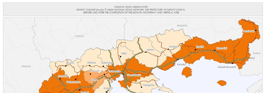
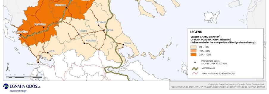
12 TRA10 indicator: Road network density 12
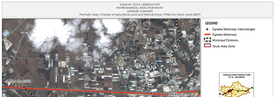
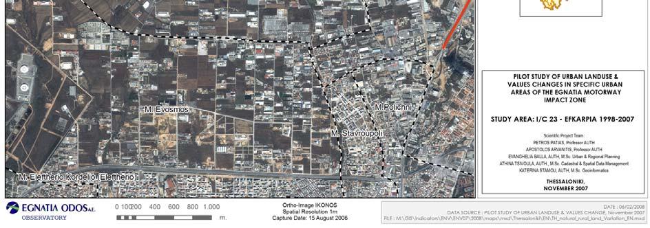
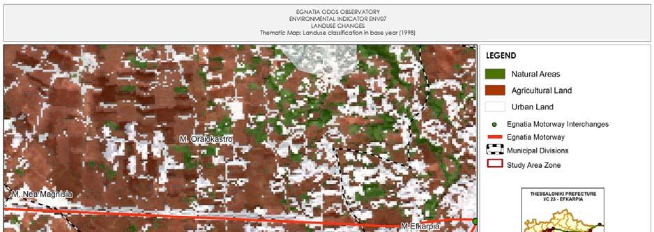
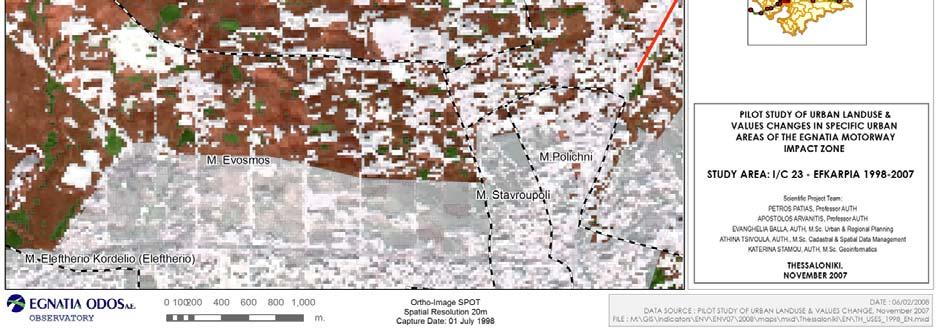
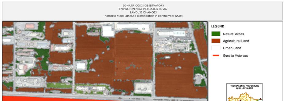
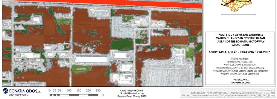
13 ENV07 indicator: Land use changes ENV07: LAND USE CHANGES Row data: «Pilot study of land uses and values in selected urban areas around 3 interchanges of the Egnatia motorway,, Contractor: Division of Cadastral, Photogrammetry and Cartography, Department of Topography, Aristole University of Thessaloniki, Greece. Target : investigation of changes in the direct impact zone of Egnatia motorway in terms of land uses, land values, and business location, in the following areas: 1. Ζone 5x5 Km around Ioannina I/C (Ioannina city, west section of the motorway) 2. Zone 5x5 Km from Efkarpia I/C (Κ4) to Ionia I/C (Κ2) (outer Thessaloniki city area, central section of the motorway). 3. Zone 5x5 Km around the East Komotini I/C (Komotini city, east section of the motorway) Landuse changes: Changes from cultivated to non-cultivated landuse as a result of expected pressures in specific areas along the motorway axis (especially near settlements, industrial areas etc.) and more specifically, rate of change of (a) cultivated land into urban land, (b) natural areas into urban land and (c) natural areas into cultivated land. 13


14 ENV07 indicator: Land use changes THESSALONIKI I/C SPOT : 088/268 IKONOS-2 Panchromatic & multispectral 14


15 ENV07 indicator: Land use changes SPOT and IKONOS samples for classification part of the classified SPOT & IKONOS images, respectively 15


16 ENV07 indicator: Land use changes Sample of the SPOT image and its equivalent IKONOS image sample, showing areas with no landuse changes, during the period. Sample of the IKONOS image, showing landuse changes during the period 16
17 ENV07 indicator: Land use changes 17
18 ENV07 indicator: Land use changes 18
19 ENV07 indicator: Land use changes 19
20 SET01 indicator: Benefited population Target : Calculation of benefited population and its changes inside the Egnatia Motorway impact zone Step 1 : Reference points definition (Impact Zone ΙΙ) 20

21 SET01 indicator: Benefited population Setup of Road Network Topology 21
")
22 SET01 indicator: Benefited population Setup of Road Network Topology Distances of up to 50 km along the national road network (daily trips) 22
23 SET01 indicator: Benefited population Road Network at a 50 km range around the local reference point 23
24 SET01 indicator: Benefited population Selection of municipal districts intersected by the 50 km range - road network around the local reference centre 24
25 SET01 indicator: Benefited population Sum of population and population changes in selected municipal districts 25
26 SET01 indicator: Benefited population Repeat of the same procedure for all the reference centres in impact zone II 26
27 SET01 indicator: Benefited population POTENTIAL BENEFITED POPULATION, 2001 (in 50 km distance from Prefecture Seats in Impact Zone II) City Permanent Benefited Population Percentage 1 Igoumenitsa % 2 Ioannina % 3 Grevena % 4 Kozani % 5 Veria % 6 Thessaloniki % 7 Serres % 8 Kavala % 9 Xanthi % 10 Komotini % 11 Alexandroupoli % Total of benefited population for 50 km (no overlaps) Total of Impact Zone II Total of Impact Zone IV Data Source: Greek National Statistics Agency,
28 SET01 indicator: Benefited population Re-estimation estimation of the indicator with Region Capitals (impact zone IV) in a distance of 150 km along the road network POTENTIAL BENEFITED POPULATION 2001, In 150 km distance from Region Capitals City Permanent Benefited Population Percentage 1 Ioannina % 2 Kozani % 3 Thessaloniki % 4 Komotini % 5 Larisa % Total of benefited population for 150 km (no overlaps) Total of Impact Zone IV Data Source: Greek National Statistics Agency,
29 ENV06 indicator: Fragmentation of natural areas Target : Effects of Egnatia Odos into natural areas cohesion Input data : Land-use layer (CORINE Land Cover) Road Network before Egnatia Odos construction Road Network with Egnatia Odos fully operational Calculation : (European Environmental Agency (ΕΕΑ)) : Anthropogenic fragmentation of potential semi- natural and natural areas ://ec.europa.eu/agriculture/publi/landscape/ch5.htmhtm Land-use classification into four main categories: Urban Areas (Pressure) Cultivated Areas (Pressure) Natural Areas Water Areas Transform into 250m GRID Road Network merge Calculation of «adjacent cells cohesion/proximity» Total of connected Cells * General Polygon Sum * 16 2 Indicator = Total Sum of Cells * General Cell Sum 29


30 ENV06 indicator: Fragmentation of natural areas Total of connected Cells * General Polygon Sum * 16 2 indicator = General Cell Sum 2 Note: Pixel size is equal to 250 m, therefore 1 km² corresponds to 4x250x250m, or 16 pixels INDICATOR SCALE Indicator < 0,01 0,01 0,1 0, > 100 Description minimum small middle average strong Very strong Model source: DG AGRI, EUROSTAT, ISPRA, EEA, From Land Cover to Landscape Diversity in the European Union,

31 Indicator Calculation Automation ENV09 indicator: Crossings with surface waters 31

32 Indicator Calculation Automation ENV09 indicator: Crossings with surface waters 32


33 Indicator Calculation Automation ENV08 indicator: Proximity to protected areas 33
 Regional Office PC/GIS workstation PC/GIS workstation PC/GIS")
34 Egnatia Odos A.E. Observatory Hardware Setup Observatory Unit GIS Workstations laptop PC 1 PC 2 IT Unit main server Department of Environment Traffic & Telematics Department Ioannina (Western Region) Regional Office PC/GIS workstation PC/GIS workstation PC/GIS workstation 34
35 ArcGIS: System Architecture Tier 1 ArcGIS (floating licenses) ArcInfo ArcEditor - ArcView user 1 user 2 user 3 user 4... user n ArcIMS Server (Internet Map Server) Tier 2 ArcSDE internet Tier 3 Data bases & file servers Database (Oracle) Main File Server Geodatabase intranet (Εgnatia Odos A.E.) 35
36 Egnatia Odos A.E. Observatory Observatory use of ArcGIS Spatial data infrastructure Indicators calculations Spatial impacts analysis and assessment Spatial Data storing and processing Descriptive data setup Linking descriptive data with spatial data Thematic map production Automation of Indicator calculation process Automation in descriptive data output. Automation in thematic map production. 36


37 Egnatia Odos A.E. Observatory
monitoring of egnatia motorways spatial impacts
 monitoring of egnatia motorways spatial impacts MINISTRY OF ENVIRONMENT, PHYSICAL PLANNING AND PUBLIC WORKS 1 A TOOL AT THE SERVICE OF SPATIAL DEVELOPMENT The Egnatia motorway Observatory monitors, and
Egnatia Odos: An axis for development and co-operation
 Egnatia Odos: An axis for development and co-operation Egnatia Odos is one of the two Trans-European transport axes (the other being PATHE) which cross through our country and, together with the Eleftherios
Observatory of Egnatia Odos motorway, Greece
 Observatory of Egnatia Odos motorway, Greece 1st Spatial Impacts Report paper presented at the Colloque scientifique sur les observatoires autoroutiers et d'infrastructures lineaires: incidences environnementales
- Socrates Seitanidis
 - Socrates Seitanidis 1. European transport policy and territorial cohesion 1.1 What is territorial cohesion? Territorial cohesion is old as a concept, (traces back to the European model of Society) but
INDICATOR RESULTS FACTSHEET TRA01: TRAFFIC VOLUME
 INDICATOR TRA01: TRAFFIC VOLUME DEFINITION - PURPOSE The indicator assesses the Annual Average Daily Traffic (), which is the average number of vehicles that travelled between two successive interchanges
Land Figures & Spatial Data Infrastructure in KOSOVO
 Land Figures & Spatial Data Infrastructure in KOSOVO Idriz SHALA idriz.shala@gmail.com GIS -expert Afrim SHARKU afrim.sharku@gmail.com Land Management - Expert Kick-off meeting of the Regional Expert Advisory
The Egnatia Motorway, Development and Combined Transports
 2005 CONGRESS ON DEVELOPMENT PREFECTURE OF KAVALA, GREECE Kavala, 25-27 November 2005 4 th Thematic Session The Egnatia Motorway, Development and Combined Transports ΕGΝΑΤΙΑ ΟDΟS Α.Ε. * translated in English
RESULTS FACT SHEET SE-F-3: ACCESSIBILITY OF SITES OF CULTURAL & TOURIST INTEREST
 DEFINITION - OBJECTIVE Currently, the indicator records the areas of tourist interest in Zone II (prefectures crossed by the Egnatia motorway) that are accessible via an interchange of the axis and their
WORKING PAPER In the context of the placement in the Observatory of the Egnatia Odos A.E.
 COMPARATIVE ANALYSIS OF POPULATION CHANGES IN THE AREAS CROSSED BY THE THREE BASIC ROAD AXES OF GREECE: THE EGNATIA MOTORWAY, THE PA.TH.E. AND THE IONIAN MOTORWAY WORKING PAPER In the context of the placement
RESULTS FACT SHEET SE-S-2: ACCESSIBILITY OF INDUSTRIAL AREAS
 RESULTS FACT SHEET SE-S-2: ACCESSIBILITY OF INDUSTRIAL AREAS DEFINITION - OBJECTIVE The indicator records data relevant to Industrial Areas (VIPE) and also other types of production and development related
The results of indicators, the reports, and generally the Observatory material are available on the internet at:
 Regional Gross Domestic Product (GDP) 2003 in the Regions of the European Union (EU25) the profile of Regions and Prefectures crossed by the Egnatia motorway The EUROSTAT, the statistical service of the
INDICATOR RESULTS FACTSHEET ΤRA04: TRAVEL-TIME
 INDICATOR DEFINITION - PURPOSE This indicator assesses the average travel-time between two points (beginningend of section), including various delays. The purpose of assessing this indicator is to determine
RESULTS FACT SHEET INDICATOR - SET13: COMPOSITION OF GROSS VALUE ADDED (GVA) PER SECTOR
 PER SECTOR") RESULTS FACT SHEET INDICATOR - SET13: COMPOSITION OF GROSS VALUE ADDED (GVA) PER SECTOR DEFINITION- OBJECTIVE This indicator records the composition of the Gross Value Added (GVA) per Prefecture/Region
RESULTS FACT SHEET INDICATOR - SET13: COMPOSITION OF GROSS VALUE ADDED (GVA) PER SECTOR DEFINITION- OBJECTIVE This indicator records the composition of the Gross Value Added (GVA) per Prefecture/Region
INDICATOR RESULTS FACT SHEET SET08: ACCESSIBLE SITES OF CULTURAL AND TOURIST INTEREST
 INDICATOR RESULTS FACT SHEET SET08: ACCESSIBLE SITES OF CULTURAL DEFINITION - OBJECTIVE The indicator determines the important areas of tourist interest of Zone ΙV that are accessible via an interchange
Tunnelling Featured Projects
 Tunnelling Featured Projects We have been involved in the following Major Tunnel Projects: Attico Metro S.A. (Athens metro underground network, http://www.attikometro.gr/) Egnatia Odos SA (670 Km motorway,
From rail timetables to regional and urban indicators on rail passenger services
 From rail timetables to regional indicators on rail passenger services Hugo Poelman Linde Ackermans European Commission DG Regional and Urban Analysis Unit - GIS team Regional ITF statistical meeting,
EGNATIA ODOS MOTORWAY - LONG TERM NOISE MONI- TORING & STRATEGIC NOISE MAPS
 EGNATIA ODOS MOTORWAY - LONG TERM NOISE MONI- TORING & STRATEGIC NOISE MAPS Chonianaki Fotini Edt consultant engineers & GENV General Partnership, 28 th October, 28, 15451 Psychiko, Athens, Greece email:
Abstract. Introduction
 Motorway Management With GIS: The Example of Attiki Odos Dr. Eng. Thanos E. Doganis Terra Ltd. Bill M. Chalkias Msc CEO of Attikes Diadromes S.A. Georgia Gania GIS Specialist Attikes Diadromes S.A. Abstract
A GIS Analysis of Probable High Recreation Use Areas in Three Sisters Wilderness Deschutes and Willamette National Forests
 Lindsey Kiesz Geo 565 Term Project 3/15/2010 A GIS Analysis of Probable High Recreation Use Areas in Three Sisters Wilderness Deschutes and Willamette National Forests Introduction The Three Sisters Wilderness
ANNEX V. List of Abbreviations
 ANNEX V List of Abbreviations SEE R&D EU TEN-T GROSEE FP NUTS LAU ESPON Cohesion SMART SWOT MEGA FUA GDP PUSH PIA TRACC RO BG GR EUROSTAT BBU OTP FYROM EC FMA FOCI ECR2 South East Europe Research and Development
MEASURING ACCESSIBILITY TO PASSENGER FLIGHTS IN EUROPE: TOWARDS HARMONISED INDICATORS AT THE REGIONAL LEVEL. Regional Focus.
 Regional Focus A series of short papers on regional research and indicators produced by the Directorate-General for Regional and Urban Policy 01/2013 SEPTEMBER 2013 MEASURING ACCESSIBILITY TO PASSENGER
DEMIFER Demographic and migratory flows affecting European regions and cities
 September 2010 The ESPON 2013 Programme DEMIFER Demographic and migratory flows affecting European regions and cities Applied Research Project 2013/1/3 Deliverable 12/06 Demifer Case Studies Thessalia
Hotel Location Analysis using ArcGIS
 Hotel Location Analysis using ArcGIS Yang Yang Department of Geography University of Florida Outline Introduction Background Data Source Research Methodology Preliminary Result Introduction Location! Location!
possession rate of vehicles and basic developmental indicators in the impact zone of Egnatia motorway, Greece THESSALONIKI, Oct.
 Αύγουστος 27 possessiion rate off vehiiclles and basiic devellopmentall iindiicators iin the iimpact zone off Egnatiia motorway,, Greece THESSALONIKI, Oct. 27 The present report gives an overview of the
Dr. Dimitris P. Drakoulis THE REGIONAL ORGANIZATION OF THE EASTERN ROMAN EMPIRE IN THE EARLY BYZANTINE PERIOD (4TH-6TH CENTURY A.D.
 Dr. Dimitris P. Drakoulis THE REGIONAL ORGANIZATION OF THE EASTERN ROMAN EMPIRE IN THE EARLY BYZANTINE PERIOD (4TH-6TH CENTURY A.D.) ENGLISH SUMMARY The purpose of this doctoral dissertation is to contribute
ΙΕΝΕ 2011 Scientific Workshop. Highways and Wildlife: How do they coexist? Kastoria, September 22, 2011
 ΙΕΝΕ 2011 Scientific Workshop Highways and Wildlife: How do they coexist? Kastoria, September 22, 2011 EGNATIA Motorway : providing sustainable engineering solutions Niki Voumvoulaki George Krinas Dept.of
NEW WEB TOOL FOR UNDERSTANDING BIOLUMINESCENT BAYS
 NEW WEB TOOL FOR UNDERSTANDING BIOLUMINESCENT BAYS Fernando Gilbes Santaella* and William Hernandez GERS Lab-Department of Geology University of Puerto Rico at Mayaguez *fgilbes@uprm.edu RESEARCH COMPONENT
Federal GIS Conference February 10 11, 2014 Washington DC. ArcGIS for Aviation. David Wickliffe
 Federal GIS Conference 2014 February 10 11, 2014 Washington DC ArcGIS for Aviation David Wickliffe What is ArcGIS for Aviation? Part of a complete system for managing data, products, workflows, and quality
SUSTAIN: A Framework for Sustainable Aviation
 SUSTAIN: A Framework for Sustainable Aviation Ted Elliff Research Area Manager, Society, Environment & Economy 1 SEMANTICS (1) The Oxford English Dictionary defines sustainable as follows: sustainable
MACEDONIA IN GREEK ADMINISTRATION
 24 M A C E D O N I A - ª π - M A K E D O N I J A MACEDONIA IN GREEK ADMINISTRATION The Balkan Wars of 1912-13 freed Macedonia from Ottoman suzerainty. Its greater part over 50 per cent of the former Ottoman
Development of the Hellenic Parts of Priority Axes No 22 & 29: A Strategic Approach
 Development of the Hellenic Parts of Priority Axes No 22 & 29: A Strategic Approach Eleni Zacharaki Intermediate Managing Authority for Transport (IMA) / Hellenic Ministry of Transport & Communications
Estimating passenger mobility by tourism statistics
 Estimating passenger mobility by tourism statistics Paolo Bolsi DG MOVE - Unit A3 Economic Analysis and Impact Assessment 2 nd International Forum Statistical meeting 1-2 April 2015 Passenger mobility
Hotel. Price Index. November Released Date: January Hotel Price Index
 Hotel Price Index November 2015 1 Released Date: January 2016 Introduction The Emirate of Abu Dhabi is one of the most attractive tourist destinations in the Middle East because of the developed infrastructure
Silvia Giulietti ETIS Conference Brussels An EEA reporting mechanism on tourism and environment and ETIS
 Silvia Giulietti ETIS Conference Brussels 28.01.2016 An EEA reporting mechanism on tourism and environment and ETIS Main content Why tourism and environment? Why a reporting mechanism on tourism and environment
Potential of CO 2 retrieval from IASI
 Potential of CO 2 retrieval from IASI L. Chaumat, O. Lezeaux, P. Prunet, B. Tournier F.-R. Cayla (SISCLE), C. Camy-Peyret (LPMAA) and T. Phulpin (CNES) Study supported by CNES ITSC-XVI: Angra dos Reis,
Spatial Assessment for the revised Mpumalanga Biodiversity Expansion Strategy. Mervyn Lotter Scientific Services 8 June 2016
 Spatial Assessment for the revised Mpumalanga Biodiversity Expansion Strategy Mervyn Lotter Scientific Services 8 June 2016 Mpumalanga Protected Area Expansion Strategy (MPAES) Developed our first MPAES
Dr Yiannis Psycharis
 The Political Economy of the Regional Allocation of Public Investment in Greece 1976-2004 Dr Yiannis Psycharis Assistant Professor Department of Planning and Regional Development, University of Thessaly,
Mapping of the theoretical potential for wind energy and small hydropower plants in the region of Peloponnesus
 Mapping of the theoretical potential for wind energy and small hydropower plants in the region of Peloponnesus Peloponnesus covers an area of some 21,550 km² (8,320 square miles) and constitutes the southernmost
IAC 2011 Cape Town, October th
 Cape Town, October 05 05 th Project Partners External Supporters and Sponsors The Problem The Solution Overview S 2 BAS Concept of Operations Architecture Possible Applications Stakeholders Flight Phases
Authentic Measurements as a Basis for Cadastral GIS
 Authentic Measurements as a Basis for Cadastral GIS Eytan Gelbman and Yerach Doytsher Technion Israel, Geo-Information Engineering 1 of 22 FIG Working Week 2009, Eilat Israel, TS2B (3303) introduction
C. SYKIANAKI, President, Organization for Planning and Environmental Protection of Athens.
 ! GENERAL PRESENTATION OF THE ATHENS METROPOLITAN REGION (AMR) C. SYKIANAKI, President, Organization for Planning and Environmental Protection of Athens. Athens, July 2006 1 ! The capital city of Athens
Robert Salmeyer Helmut Fellner. Jaroslav Dupal. Mihaly Lados
 DANUBE SPACE STUDY Regional and Territorial Aspects of Development in the Danube Countries with Respect to Impacts on the European Union Final Report July 2000 Commissioned by: European Commission DG:
Economic impact of the Athens International Airport
 FOUNDATION FOR ECONOMIC & INDUSTRIAL RESEARCH 11 T. Karatassou St, 11742 Athens, Greece, Tel: (+30) 210 9211 200-10, Fax: (+30) 210 9233 977, www.iobe.gr Economic impact of the Athens International Airport
Aircraft Noise. Why Aircraft Noise Calculations? Aircraft Noise. SoundPLAN s Aircraft Noise Module
 Aircraft Noise Why Aircraft Noise Calculations? Aircraft Noise Aircraft noise can be measured and simulated with specialized software like SoundPLAN. Noise monitoring and measurement can only measure the
Egnatia Odos, a tollway from the past to the future
 Egnatia Odos, a tollway from the past to the future, Director of Exploitation and Growth, EGNATIA ODOS SA 1 Contents Historical reference of Egnatia Implementation and impact of Egnatia Odos Traffic figures
Note that the steepest 8 direction pour point model slope in direction 64 is: 10.0
 GIS in Water Resources Exercise #3 Solution Part 1. 1.1 Hand Calculations (i) The standard ESRI surface slope function Grid size 10 m Diagonal distance= 14.142 m 47.5 48 47.7 50.6 48.3 dz/dx= -0.125 45.1
South Aegan Region (Greece)
") South Aegan Region (Greece) South Aegan Region 1. Introduction The South Aegean Region is situated in the south-eastern border of Greece and constitutes at the same time, along with Cyprus, the south-eastern
South Aegan Region (Greece) South Aegan Region 1. Introduction The South Aegean Region is situated in the south-eastern border of Greece and constitutes at the same time, along with Cyprus, the south-eastern
Inspection system for in use pesticide application equiupment in Greece. First three years of application
 Inspection system for in use pesticide application equiupment in Greece. First three years of application G. Bourodimos 1,2, A. T. Balafoutis 3, M. Giamouri 1, S. Fountas 2 1 Hellenic Agricultural Organisation
Regional fact sheets Municipality of Langadas
 Regional fact sheets Municipality of Langadas Deliverable D4.2 Aristotle University of Thessaloniki Transport Systems Research Group Evangelos Genitsaris Panagiotis Tsalis September 2014 Contract N : IEE/12/970/S12.670555
ACCOMMODATION from the supply side
 UNWTO Statistics Capacity Building Program WORKSHOP IV 18-20 November 2009 Vienna, Austria Reporting on the observation of collective ACCOMMODATION from the supply side DijanaMili, MinistryofTourism of
A Guide to the ACi europe economic impact online CALCuLAtoR
 A Guide to the ACI EUROPE Economic Impact ONLINE Calculator Cover image appears courtesy of Aéroports de Paris. 2 Economic Impact ONLINE Calculator - Guide Best Practice & Conditions for Use of the Economic
Presented by: Ms. Kanageswary Ramasamy Department of Statistics, Malaysia February 2017
 Presented by: Ms. Kanageswary Ramasamy Department of Statistics, Malaysia 14-16 February 2017 1 INTRODUCTION 2 INTERNATIONAL RECOMMENDATIONS ON TOURISM STATISTICS (IRTS) 2008 3 RECOMMENDED METHODOLOGICAL
Travel behavior as a determining factor for sustainable transport measures
 Travel behavior as a determining factor for sustainable transport measures place Polykarpos Karkavitsas your Transport consultant of the Municipality of Kordelio-Evosmos logo here Georgios Makridis / Mechanical
December Release Date February 2015 Hotel Price Index
 December 2014 Release Date February 2015 1 Introduction The Emirate of Abu Dhabi is one of the most attractive tourist destinations in the Middle East because of the developed infrastructure and quality
Fiji s Tourism Satellite Accounts
 Asia-Pacific Economic Statistics Week Bangkok 2 4 May 2016 Fiji s Tourism Satellite Accounts Mr. Bimlesh Krishna Divisional Manager Economic Statistics Fiji s Tourism Satellite Introduction The Tourism
Social Community Accessibility
 Social Community Accessibility Australian Geography Teachers Conference 8-12 January University of Tasmania Launceston NEIL COFFEE UNIVERSITY OF ADELAIDE Geography V GIS? National Centre for Social Applications
Introduction. Hotel Price Index
 1 Introduction The tourism sector in the United Arab Emirates became one of the most important sectors that have evolved remarkably in recent years. The Emirate of Abu Dhabi is one of the most attractive
HELLENIC REPUBLIC Voluntary National Review on the Implementation of the 2030 Agenda for Sustainable Development. 16 July 2018
 HELLENIC REPUBLIC Voluntary National Review on the Implementation of the 2030 Agenda for Sustainable Development 16 July 2018 1 HELLENIC REPUBLIC Voluntary National Review on the Implementation of the
SHIP MANAGEMENT SURVEY. July December 2017
 SHIP MANAGEMENT SURVEY July December 2017 INTRODUCTION The Ship Management Survey is conducted by the Statistics Department of the Central Bank of Cyprus and concentrates primarily on transactions between
Integrated Management of Shared Lakes Basins. Ohrid and Prespa Lake -Transboundary Cooperation-
 Integrated Management of Shared Lakes Basins Ohrid and Prespa Lake -Transboundary Cooperation- Mrs. Darinka Jantinska, Bilateral Cooperation Head of Division, Ministry of Environment and Physical Planning,
Airspace Complexity Measurement: An Air Traffic Control Simulation Analysis
 Airspace Complexity Measurement: An Air Traffic Control Simulation Analysis Parimal Kopardekar NASA Ames Research Center Albert Schwartz, Sherri Magyarits, and Jessica Rhodes FAA William J. Hughes Technical
Tourism Satellite Account: Demand-Supply Reconciliation
 Tourism Satellite Account: Demand-Supply Reconciliation www.statcan.gc.ca Telling Canada s story in numbers Demi Kotsovos National Economic Accounts Division Statistics Canada Regional Workshop on the
S.Y.K.A.P. GREEK COORDINATION CENTRE AGAINST ILLICIT TRADE
 S.Y.K.A.P. GREEK COORDINATION CENTRE AGAINST ILLICIT TRADE Ministry of Development & Competitiveness General Secretariat of Commerce Composition of SYKAP The Ministry of Development and Competitiveness
PAGONI CONSTRUCTION COMPANY
 PAGONI CONSTRUCTION COMPANY COMPANY PROFILE CONTENTS 1. ACTIVITY 2. HISTORY 3. ADMINISTRATION CHART 3.1 ADMINISTRATION CHART REFERENCES 4. PROJECTS 1. ACTIVITY Pagoni Construction Company services the
Management System for Flight Information
 Management System for Flight Information COP 5611 Chantelle Erasmus Page 1 of 9 Project Phases Design Phase (100 percent complete)... 3 Initial Implementation and Testing Phase (0 percent complete)...
The Egnatia Motorway a chance for Northern Greece to catch up?
 Stefano Panebianco, Carsten Schürmann The Egnatia Motorway a chance for Northern Greece to catch up? Paper presented at the 42 nd Congress of the European Regionanl Science Asociation (ERSA), Dortmund,
Data Limitations. Index Choices
 Section 3. Annexes The Index is part of a central database and system for collecting data on regional integration. It will capture additional data for indicators that are not part of the Index but that
The regional value of tourism in the UK: 2013
 Article: The regional value of tourism in the UK: 2013 Estimates of the economic value of tourism within UK regions and sub-regions. It includes supply and demand data relating to tourism and tourism industries.
From S to sigma: towards a new development pattern of the Hellenic space? Is there a role for Mega Transport Projects in spatial restructuring?
 UNIVERSITY OF THESSALY SCHOOL OF ENGINNERING DEPARTMENT OF PALNNING AND REGIONAL DEVELOPMENT (DPRD) Research Unit of infrastructure, Technology Policy & Development From S to sigma: towards a new development
INTERREG III C. POLYMETREXplus RINA: North-South Interface Inception Meeting ATHENS JULY, 2006
 INTERREG III C POLYMETREXplus RINA: North-South Interface Inception Meeting ATHENS JULY, 2006 MAGDALINI K. SEGKOUNI E-MAIL: msegkouni@orth.gr ORGANISATION OF PLANNING AND ENVIRONMENTAL PROTECTION OF THESSALONIKI
ACTION PLAN SUMMARY I. IMPROVING TECHNICAL STANDARDS AND RELATED RULES. NOX More stringent international rules By 2001 (33 rd ICAO Assembly)
") ACTION PLAN SUMMARY AREA OBJECTIVES/TARGETS/ACTIONS TARGET DATES I. IMPROVING TECHNICAL STANDARDS AND RELATED RULES 1. Noise More stringent international standards and rules for transition By 21 (33 rd
ACTION PLAN SUMMARY AREA OBJECTIVES/TARGETS/ACTIONS TARGET DATES I. IMPROVING TECHNICAL STANDARDS AND RELATED RULES 1. Noise More stringent international standards and rules for transition By 21 (33 rd
Creative Industries in Greece
 Creative Industries in Greece Alina Hyz Kostas Karamanis Creative Industries in Greece An Empirical Analysis from the Region of Epirus Alina Hyz Piraeus University of Applied Sciences, Greece Kostas Karamanis
L. Issaia - Keramida Consultant to the Managing Director of ERGOSE
 L. Issaia - Keramida Consultant to the Managing Director of ERGOSE THE MODERNIZATION PROJECTS OF OSE S RAILWAY NETWORK, WHICH ARE IMPLEMENTED WITH THE FINANCIAL SUPPORT OF EUROPEAN UNION FUNDS (EUROPEAN
Other Principle Arterials Minor Arterial Major Collector Minor Collector Local
 CHAPTER 10 TRANSPORTATION Introduction The system of public roads in East Pikeland Township is decidedly rural in character. Since the 1984, the road network has remained much the same, with the addition
Sustainable development: 'Lanzarote and the Biosphere strategy'. LIFE97 ENV/E/000286
 Sustainable development: 'Lanzarote and the Biosphere strategy'. LIFE97 ENV/E/000286 Project description Environmental issues Beneficiaries Administrative data Read more Contact details: Project Manager:
Annex 1 to letter 0426(DPRM.REM)1035 of 16 April I. Articles 28 and 29 of the UPU Convention. Article 28 Terminal dues. General provisions
1035 of 16 April I. Articles 28 and 29 of the UPU Convention. Article 28 Terminal dues. General provisions") Annex 1 to letter 0426(DPRM.REM)1035 of 16 April 2018 I. Articles 28 and 29 of the UPU Convention Article 28 Terminal dues. General provisions 1 Subject to exemptions provided in the Regulations, each
Annex 1 to letter 0426(DPRM.REM)1035 of 16 April 2018 I. Articles 28 and 29 of the UPU Convention Article 28 Terminal dues. General provisions 1 Subject to exemptions provided in the Regulations, each
Related Expertise Concession Projects - PPP
 Related Expertise Concession Projects - PPP IMPETUS-ISIS for Attiki Odos ISIS and Impetus developed a traffic model for the offer that Attiki Odos, SA had provided in the bidding process and won the contract
CURRICULUM VITAE. NICKOLAS STROBLOS Statisticiaan and National Accountant Director, Hellen. nic Statistics Authority (EL.STAT.)
") CURRICULUM VITAE NICKOLAS STROBLOS Statisticiaan and National Accountant Director, Hellen nic Statistics Authority (EL.STAT.) 1. PERSONAL Place of birth: Nationality: Marital status: e-mail: Aigina,, GREECE
CURRICULUM VITAE NICKOLAS STROBLOS Statisticiaan and National Accountant Director, Hellen nic Statistics Authority (EL.STAT.) 1. PERSONAL Place of birth: Nationality: Marital status: e-mail: Aigina,, GREECE
JR East: International and Domestic Perspectives
 Peer Group Comparisons In this section, several key performance indicators illustrate how JR East compares with selected well-known companies. In scale and profitability, JR East is not to be outdone by
PREFACE. Service frequency; Hours of service; Service coverage; Passenger loading; Reliability, and Transit vs. auto travel time.
 PREFACE The Florida Department of Transportation (FDOT) has embarked upon a statewide evaluation of transit system performance. The outcome of this evaluation is a benchmark of transit performance that
Development of an integrated transportation system in Thessaloniki: current situation and future prospects
 CHAPTER 8 Development of an integrated transportation system in Thessaloniki: current situation and future prospects S. Basbas, G. Mintsis & C. Taxiltaris Aristotle University of Thessaloniki, School of
Performance Indicator Horizontal Flight Efficiency
 Performance Indicator Horizontal Flight Efficiency Level 1 and 2 documentation of the Horizontal Flight Efficiency key performance indicators Overview This document is a template for a Level 1 & Level
ANNEX C. Maximum Aircraft Movement Data and the Calculation of Risk and PSZs: Cork Airport
 ANNEX C Maximum Aircraft Movement Data and the Calculation of Risk and PSZs: Cork Airport CONTENTS C1 INTRODUCTION C1 C2 SUMMARY OF INPUT DATA C2 C3 AIRCRAFT CRASH RATE C5 C3.1 AIRCRAFT CLASSIFICATION
PRESS RELEASE. ARRIVALS OF NON-RESIDENTS IN GREECE: January - June 2016 HELLENIC REPUBLIC HELLENIC STATISTICAL AUTHORITY. Piraeus, 13 October 2016
 HELLENIC REPUBLIC HELLENIC STATISTICAL AUTHORITY Piraeus, 13 October 2016 PRESS RELEASE ARRIVALS OF NON-RESIDENTS IN GREECE: January - June 2016 According to the Frontier Statistical Survey conducted by
SPADE-2 - Supporting Platform for Airport Decision-making and Efficiency Analysis Phase 2
 - Supporting Platform for Airport Decision-making and Efficiency Analysis Phase 2 2 nd User Group Meeting Overview of the Platform List of Use Cases UC1: Airport Capacity Management UC2: Match Capacity
AMSTERDAM. Yearbook: Summary Results 180
 AMSTERDAM Amsterdam is the capital of the Netherlands and the country's cultural, financial and commercial services centre. The NUTS 3 Greater-Amsterdam region is located in the northern part of the predominantly
7. Demand (passenger, air)
") 7. Demand (passenger, air) Overview Target The view is intended to forecast the target pkm in air transport through the S-curves that link the GDP per capita with the share of air transport pkm in the
7. Demand (passenger, air) Overview Target The view is intended to forecast the target pkm in air transport through the S-curves that link the GDP per capita with the share of air transport pkm in the
Baku, Azerbaijan November th, 2011
 Baku, Azerbaijan November 22-25 th, 2011 Overview of the presentation: Structure of the IRTS 2008 Main concepts IRTS 2008: brief presentation of contents of chapters 1-9 Summarizing 2 1 Chapter 1 and Chapter
HELLENIC NAVY HYDROGRAPHIC SERVICE. XVI th MEDITERRANEAN AND BLACK SEAS HYDROGRAPHIC COMMISSION NATIONAL REPORT OF GREECE
 HELLENIC NAVY HYDROGRAPHIC SERVICE XVI th MEDITERRANEAN AND BLACK SEAS HYDROGRAPHIC COMMISSION NATIONAL REPORT OF GREECE Odessa - Ukraine, 22-24 September 2009 1. Hydrographic Service: General Hellenic
along a transportation corridor in
 Rockfall hazard and risk assessment along a transportation corridor in the Nera Valley, Central Italy Presentation on the paper authored by F. Guzzetti and P. Reichenbach, 2004 Harikrishna Narasimhan Eidgenössische
Special Coordination Service for Implementation (SCOS) - ROLE
 - ROLE") Introduction MINISTRY OF ECONOMY & DEVELOPMENT Special Coordination Service for Implementation (SCOS) - ROLE The role & responsibilities of SCOS is specified in L.2860/2000, L.3614/2007, L.4314/2014 and
Introduction MINISTRY OF ECONOMY & DEVELOPMENT Special Coordination Service for Implementation (SCOS) - ROLE The role & responsibilities of SCOS is specified in L.2860/2000, L.3614/2007, L.4314/2014 and
Procedures of obtaining the exploitation permit for the utilization of geothermal energy
 Procedures of obtaining the exploitation permit for the utilization of geothermal energy Geothermal Energy in South-East Europe Stuttgart, 30 November 2009. Republic of Serbia - Ministry of Mining and
EO-based services to support humanitarian operations: monitoring population and natural resources in refugee/idp camps
 How satellites can help to save lives Vienna, Austria 23 February 2016 EO-based services to support humanitarian operations: monitoring population and natural resources in refugee/idp camps Petra FÜREDER
Thessaloniki Chamber of Commerce & Industry TCCI BAROMETER. March Palmos Analysis. March 11
 Thessaloniki Chamber of Commerce & Industry TCCI BAROMETER March 2011 Palmos Analysis March 11 TCCI BAROMETER (Executive Summary) Thessaloniki Chamber of Commerce and Industry (TCCI), consistent to its
Socio-demographic and Economic Profiles of the Regions in the Republic of Macedonia
 Spatial demography of the Balkans: trends and challenges IV th International Conference of Balkans Demography Session 5: Planning and development challenges -----------------------------------------------------------------------------------------------
PRESS RELEASE. Graph 1: Road traffic accidents and casualties, January January Jul-14. Jul-15. Apr-15. Jan-15. Oct-15.
 Jan-11 Apr-11 Jul-11 Oct-11 Jan-12 Apr-12 Jul-12 Oct-12 Jan-13 Apr-13 Jul-13 Oct-13 Jan-14 Apr-14 Jul-14 Oct-14 Jan-15 Apr-15 Jul-15 Oct-15 Jan-16 Apr-16 Jul-16 Oct-16 Jan-17 Apr-17 Jul-17 Oct-17 Jan-18
Efficiency and Environment KPAs
 Efficiency and Environment KPAs Regional Performance Framework Workshop, Bishkek, Kyrgyzstan, 21 23 May 2013 ICAO European and North Atlantic Office 20 May 2013 Page 1 Efficiency (Doc 9854) Doc 9854 Appendix
HRADF: Putting Greek economy into long-term perspective
 HRADF: Putting Greek economy into long-term perspective Takis Athanasopoulos Chairman Athens, 24 th January 2013 HRADF is the Agency embedded with the task of executing the privatisations programme of
THE MORPHOLOGY AND TYPOLOGY OF THE OTTOMAN MOSQUES OF NORTHERN GREECE
 THE MORPHOLOGY AND TYPOLOGY OF THE OTTOMAN MOSQUES OF NORTHERN GREECE MARIA LOUKMA & MARIA STEFANIDOU Laboratory of Building Materials, Aristotle University of Thessaloniki, Greece ABSTRACT The present
MARSHALL Subdivision. Township of Springwater, County of Simcoe. Traffic Brief for: Ontario Inc. Type of Document: Final Report
 MARSHALL Subdivision Township of Springwater, County of Simcoe Traffic Brief for: 489469 Ontario Inc. Type of Document: Final Report Project Number: JDE 1521 Date Submitted: October 19 th, 2016 10 / 19