KHALASMENO AND KATALIMATA
|
|
|
- Liliana Preston
- 6 years ago
- Views:
Transcription

.")
1 KHALASMENO AND KATALIMATA TWO EARLY IRON AGE SETTLEMENTS IN MONASTIRAKI, EAST CRETE (PLATEs 68-73) T HIS REPORT represents a single component of the Kavousi-Thriphti Survey, which is the study of the topography and archaeology of the region of Kavousi and the environs of the Early Iron Age sites of Vronda and Kastro.1 The focus of the survey is to provide a broad environmental and chronological context for the Kavousi Project excavations and to assess changes in settlement patterns in the Bronze Age and Early Iron Age in this area of eastern Crete (Figs. 1, 2). Survey was conducted at Khalasmeno and Katalimata to document two new Late Minoan (LM) IIIC settlements that have substantial artifacts and architectural remains suitable for assessing and comparing site size, chronology, and function but are rapidly succumbing to erosion and other destructive agents, both natural and anthropogenic. A secondary aim of fieldwork was to examine two Early Iron Age sites of similar size and date that are topographically associated but situated in entirely different physical environments and might therefore have been settled for different reasons.2 Katalimata and Khalasmeno are located in the district ofkavousi on the extreme western edge of the Siteia mountains (Thriphti range) overlooking the north Isthmus of Ierapetra (Figs. 1, 2). The sites are situated on the north and south sides of the Kha gorge, about 2 kilometers east of the Early Minoan settlement of Vasiliki and about 600 meters northnortheast of the village of Monastiraki (Figs. 2, 3; P1. 68:a, c). The Kha gorge is a well-known east Cretan landmark, consisting of a V-shape, 700 meters high, sliced into the western front of the Thriphti range; it forms the main southwest drainage basin for the west Siteia massif. The nearest perennial spring is at Monastiraki village, and river water, collecting at the base of the gorge, is accessible even in dry summer months. 1 For the broad aims of the Kavousi-Thriphti survey, see Haggis 1992; for the Dark Age settlements, see Haggis 1990, p For the Kavousi Project, see Gesell, Day, and Coulson 1983 and, most recently, Gesell, Day, and Coulson 1988 and Gesell, Coulson, and Day The survey of the sites of Katalimata and Khalasmeno was undertaken in 1989 and 1990 as part of the Kavousi-Thriphti Survey, a component of the Kavousi Project. Fieldwork was conducted under the auspices of the American School of Classical Studies at Athens and with the permission of the Greek Ministry of Culture and the KA' Ephoreia of Prehistoric and Classical Antiquities. Support was provided by a Fulbright Collaborative Research Grant and the American School of Classical Studies at Athens. We wish to thank Costis Davaras, Metaxia Tsipopoulou, and Nikos Papadakis of the Ephoreia of Eastern Crete and the Directors of the Kavousi Project, Geraldine C. Gesell, Leslie Preston Day, and William D. E. Coulson, for encouraging this project and for providing much useful input. We are indebted to Georgos Gammatikakis of Kavousi and Manolis Zigakis (tou reapyou) of Vasiliki, whose knowledge of the Monastiraki area was invaluable. We are especially grateful to L. Vance Watrous, G. C. Gesell, L. P. Day, William Coulson, and Margaret S. Mook for reading drafts of this paper and for much helpful criticism. The map of east Crete (Fig. 1) was prepared by Lee Ann Turner of the University of Pennsylvania. Hesperia 62.3 (1993) American School of Classical Studies at Athens is collaborating with JSTOR to digitize, preserve, and extend access to Hesperia
2 E 0 ~ ~ ~ ~ ~ ~~~~ 0~~~~~~~~~~~~~~~~~~ N N vl) U, E~~~~~~~~~~~~~~~~~~~~~~~~~~~~~~~~~~~~~. 0 0~~~~~~~ 0~~~~~~~~~~~. Q4 tyl.2~~~~~~~~
. While the toponym, KhalaOBsmeno (\"ruin\"), betrays traditional recollection of ancient remains, the site was unknown, even to the local landowner.")
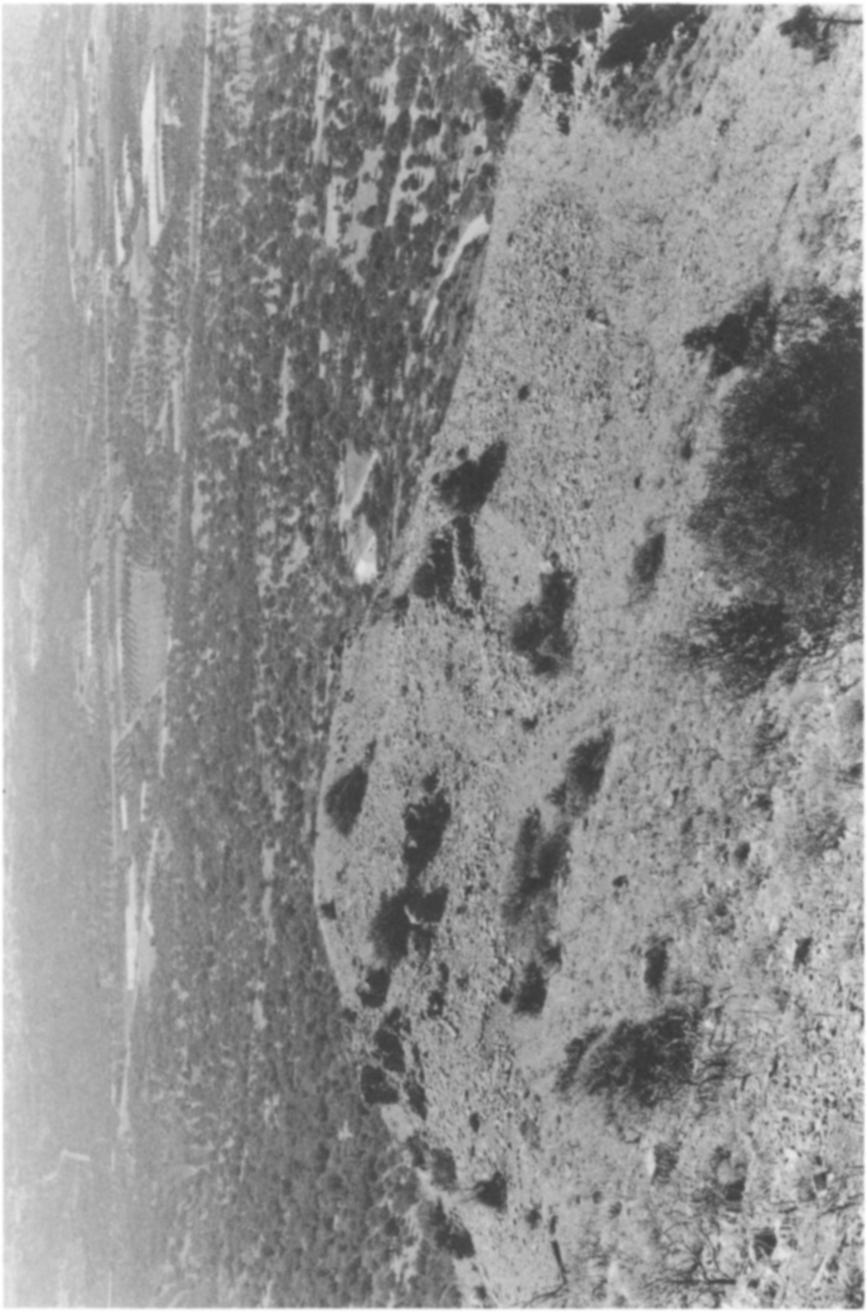
3 KHALASMENO AND KATALIMATA: TWO EARLY IRON AGE SETTLEMENTS 305 Khalasmeno is a distinctly rounded hill about 230 meters above sea level immediately south of the gorge on the southern edge of the Kha river (Fig. 3; P1. 68). While the toponym, KhalaOBsmeno ("ruin"), betrays traditional recollection of ancient remains, the site was unknown, even to the local landowner.3 The west slope of the hill is covered with abandoned terraces, which were used as late as the 1950's for barley; other terraces extending up the steep slope of the Lamia cliffs, just east of the summit, are further evidence of recent agricultural use. Khalasmeno is today used as grazing land for the Monastiraki shepherd, and a derelict mandra (sheep pen) in the center of the site suggests traditional herding activity. Some 300 meters north-northeast of Khalasmeno, within the gorge itself on its north side, is the settlement of Katalimata. The site is situated about halfway up the north cliff of Kha (ca. 350 meters above sea level) on a series of limestone ledges on the outer west face and inner south face of the mouth of the gorge (Fig. 3; Pls. 68:a, c at 2, 70). Trace remains of Turkish glazed wares corroborate local reports that the site was used as a refuge settlement during the Turkokratia, and Monastiraki residents today remember similar use of the location during the German occupation. Today goats from herds at Papoura are often seen grazing on the precarious stone ledges, and except for the occasional hunter or archaeologist, the site is rarely visited. Katalimata has been known since 1903, when Harriet Boyd [Hawes] recorded some "geometric pottery" from the location: Even more inaccessible [than Vrokastro], although not of equal height, is a ledge in the Thriphti Range, just above a deep gorge, east of Monastiraki. With a spyglass one decries characteristic Iron Age walls, and our foreman, Aristides Pappadias, scaled the cliff and brought down fragments of geometric pottery gathered in the midst of house ruins like those on the Citadel [Kastro]. Perhaps one day I shall go there myself, but my eyes will have to be blindfolded.4 Pendlebury also mentions Katalimata in his catalogue of Geometric sites in The Archaeology of Crete, but there is no indication that he or Boyd ever visited the site, and no pottery or architecture was ever published.5 It was perhaps the extreme inaccessibility and precarious location of the site, high in the cliffs of the Kha gorge, that discouraged early archaeological investigation. Katalimata and Khalasmeno are situated on the Isthmus of lerapetra, the shortest land route between north and south coasts on Crete. The sites have a western aspect and are only accessible from the plain. Although passage to the fertile mountain valley of Thriphti is possible from Monastiraki, by means of a Turkish-period kalderimi (cobbled 3 Pendlebury, Pendlebury, and Money-Coutts ( , p. 137) mention a "Palaialimata," of LM IIIC- SM (Subminoan) date, above the village of Monastiraki. The toponym Palaialimata is unknown to modern inhabitants of Monastiraki and Vasiliki, and intensive survey has revealed no other LM IIIC settlement in the vicinity. It is possible that Palaialimata is Pendlebury's confusion or conflation of Katalimata and an obsolete toponym for Khalasmeno. Kanta (1980, p. 161), after Pendlebury, lists Palaialimata in the site catalogue. The findspot of Khalasmeno was first published by Nowicki (1990, pp ). 4 Boyd 1904, pp Pendlebury 1939, p. 326.
4 306 DONALD C. HAGGIS AND KRZYSZTOF NOWICKI kilometers A 179 Thotos KGmposD A FIG. 2. Map of Kavousi-Thriphti Survey zone
5 Khci River>, FIM. 3. Map of Monasiraki area: Khalasmeno and Katalimata

6 308 DONALD C. HAGGIS AND KRZYSZTOF NOWICKI path), the mountain fronts of Papoura and Lamia present a natural barrier to the eastern hinterland (Figs. 2, 3). The topography thus indicates orientation to the west and toward the intersection of the major north-south and east-west transportation routes in east Crete, a factor necessarily important in the siting of the two settlements. The topography and proximity of the sites to each other point to some kind of interrelationship and possible functional differences. THE SURVEY Fieldwork was conducted at the sites of Monastiraki for two weeks in While initial and preliminary reconnaissances had been carried out by the authors on separate occasions in 1987,6 a complete and detailed survey of Khalasmeno and Katalimata was a collaborative effort, whose purpose was to draw topographical and sketch plans of the extant architecture and to collect and study a sample of surface pottery. The site-sampling methods employed at the two sites were inconsistent because of the vastly different terrains encountered. At Khalasmeno, the sampling units were long, rectangular units, two meters wide, extending out from the notional center of the site along the cardinal radii. Sherds were counted in units five meters long and two meters wide to determine artifact densities and to establish the boundaries of the site. Sherd material was concentrated within limits of the visible architecture. All pottery, stone tools, and other artifacts were collected along the transects, irrespective of specific location. Pottery from each transect was collected, sorted, and recorded, and then a "grab sample" of diagnostic sherds was collected from each of the four quadrants formed by the bisecting transects. At Katalimata, the steep and precarious terrain made site-sampling difficult. Here individual, long transects, situated along each of four terraces (B, C, E, and K; see Fig. 8), comprised the sample area. Pottery was counted and recorded as in the radial transects at Khalasmeno. A grab sample was collected along each of the topographically distinct bedrock terraces. KHALASMENO Khalasmeno (Fig. 4; P1. 68) consists of at least 27 units of architecture, perhaps separate rooms, spreading over the top of the hill, a clearly defined and discrete area of some 0.65 hectares. The hill is contained on the north by the deeply incised Kha river bed and on the south by a torrent fed from the cliffs to the east. Immediately east of the summit is a steep slope of colluvial debris climbing east to the vertical cliffs of Lamia (Fig. 3; P1. 68:a, c). To the northeast of the setfiement, on the very edge of the south side of the Kha gorge, is another cluster of ancient house walls whose plan and extent could not be determined because of thick scree cover and dense vegetation. The architecture of Khalasmeno consists of wall lines visible at various levels, from foundations up to three courses. Even with 100 percent ground visibility, walls are often 6 See Haggis 1990 and Nowicki 1990, pp
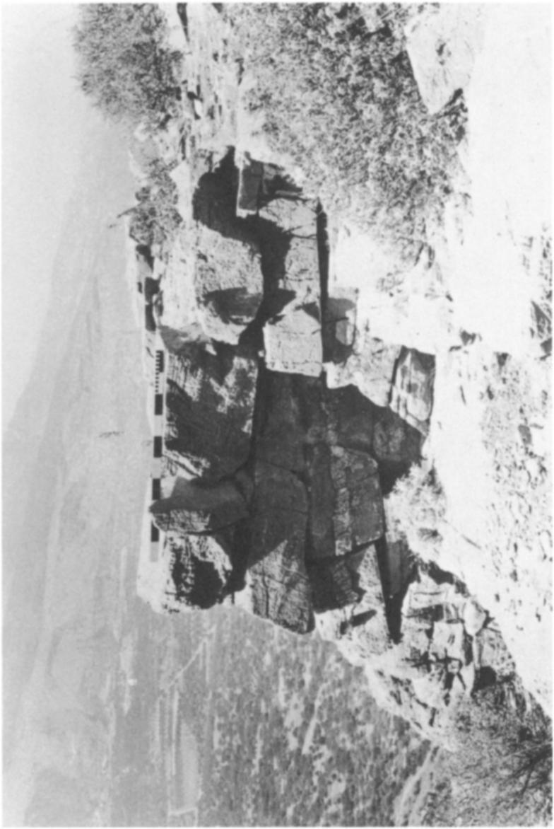
7 KHALASMENO AND KATALIMATA: TWO EARLY IRON AGE SETTLEMENTS ~~~~~~~~~~~~~~~c 0~~~~~~~~~~~ KHALASMENO FIG. 4. Plan of Khalasmeno covered by stone tumble, and in the central area of the settlement, units 2-5 have been obscured by a large mandra or shepherd's hut (unit 5 on Fig. 4). House and room units could be detected by concentrations of pottery and stone tumble, but only ancient walls identified with certainty were drawn on the sketch plan. Immediately east-northeast of units 8-10 is another possible house, which consists of only a stone pile obscured by vegetation. The pottery scatter over the entire hilltop is dense, and ceramic remains appear to be localized within the wall lines and rarely extend beyond the area of visible architecture. Given the uniformity of the terrain and the high level of visibility, it is likely that the full horizontal extent of the settlement is preserved and visible on the ground surface.
 shows two main areas of building, which appear to be divided by a main east-west street that passes between units 22 (north) and 18-19 (south), widening into a broad street or courtyard between")
8 310 DONALD C. HAGGIS AND KRZYSZTOF NOWICKI The sketch plan of the settlement (Fig. 4) shows two main areas of building, which appear to be divided by a main east-west street that passes between units 22 (north) and (south), widening into a broad street or courtyard between units 5 and 6. The first area consists of units 6-20 in the southern part; the second, units 1-5 and 21-27, is in the northern. As at Vronda, Kastro,7 Karphi, and Vrokastro, these units are contiguous and make ample use of the bedrock outcrops in wall construction (especially 6-8 and 11, 12, and 14).8 Walls average 0.60 m. wide, where two faces are visible, and are constructed of local limestone fieldstones. No dressed stone was apparent, but this is probably a condition of preservation. Doorways, indicated by breaks in the fieldstone construction, are certain between units 22 and 24 and units 18 and 19, and a house entrance is apparent on the east side of unit 10. Units 12, 17, and 24 possibly are storage areas, auxiliary rooms, or closets, and unit 9 is an enclosed porch or vestibule.9 Units 13 and 15 are probably exterior courtyards, supported by retaining walls along the south (P1. 69:a). While doorways and certain room and house divisions are often impossible to determine from the surface remains, several recurring patterns of construction appear, which fit into the LM III and Early Iron Age house typology as defined by Hayden.10 Although the areas of 2-5, 20, and 21 are too obscure to make designations certain, by using Hayden's typology it is possible to suggest a total number of house units between 12 and 16. Unit 8 appears to be a one-room house with an auxiliary room, porch, or court (unit 9), a characteristic of LM III plans."1 Two-room and three-room plans, such as 22-24, 18-19, 16-17, and possibly 2-3, are most common. Additionally, the elongated form of units 1 and 4, while uncertain in plan, is either a one-room house or an axially arranged twoor three-room type.12 A larger, more elaborate plan (apparent at Vronda, Vrokastro, and Karphi) has auxiliary rooms situated alongside a main chamber. 13 At Khalasmeno, a similar arrangement can be seen in units and 6-7; units 25-27, however, might be two separate houses consisting of a one-room house (25) and an axial two-room house (26-27). The terrain of the Khalasmeno summit is essentially level, and in this respect it is dissimilar to such Iron Age sites as Kastro, Vrokastro, or Karphi. The LM IIIC settlement at Vronda, however, is remarkably similar to Khalasmeno in terrain, size, plan, and population capacity. Vronda covers an area (ca ha.) equivalent to Khalasmeno, and as in the latter, the maximum number of houses is between 12 and At both sites, the simple two- and three-room house plans prevail, with access between rooms provided by breaks in party walls 7 Unless otherwise indicated, references to "Kastro" or "the Kastro" in this text refer to the Kastro at Kavousi; for the Kastro, see Gesell, Day, and Coulson 1985 and Gesell, Coulson, and Day 1991; likewise, "Kastri" in the text refers to Palaikastro Kastri (Sackett and Popham 1965). 8 Hayden 1983, p. 374; Day, Coulson, and Gesell 1986, p. 385; Gesell, Day, and Coulson 1985, p On internal closets in LM IIIC, see Day, Coulson, and Gesell 1986, p. 386 (Rooms A9 and El); Hayden 1981, pp. 79, Hayden 1981, pp ; Hayden 1983, pp ; Hayden 1987; see also McEnroe 1979, pp Hayden 1981, pp ; Day, Coulson, and Gesell 1986, p On the axial plan in LM III, see Hayden 1981, pp Hayden 1983, p. 385; Hayden 1981, p. 134; Gesell, Coulson, and Day 1991, p. 147, Vronda: Buildings I, C, and D. 14 Gesell, Coulson, and Day 1991, p. 147.
, and room sizes are identical (ca.")
9 KHALASMENO AND KATALIMATA: TWO EARLY IRON AGE SETTLEMENTS 311 rather than by halls or vestibules.15 Houses and rooms at both sites are clustered together in an aggregate fashion (Vronda, Buildings N and I, and C and D; Khalasmeno, units 22-27, 15-19, and 6-13), and room sizes are identical (ca sq. m.). In addition to the simple aggregate plan, some buildings appear axially arranged. While the LM III "axial plan", as defined by Hayden and McEnroe, is the norm at Vrokastro and in Geometric levels on the Kastro, because of the suitability of the arrangement to the steeply contoured terrain, it is interesting that it appears also at Khalasmeno, which is a fairly level hilltop, requiring only minimal terracing. 16 THEP OTTERY Fine Wares The surface pottery from Khalasmeno appears to be predominantly LM IIIC in date. 17 Indications of late LM IIIC are the cylindrical pyxis base (26; Fig. 5) and rim (1; Fig. 5, P1. 69:b) with pendent multiple triangles. There are good parallels for the shape at Karphi, and the element of hatching and triangles in an upper or middle register is typical of LM IIIC stirrup jars, jugs, and pyxides.'8 Also found were two fragments of pyxis handles that were applied to and continued down the body of the vessel to the base or to a point short of the base. 19 Of certain LM IIIC date is a small, deep bowl (2; Fig. 5, P1. 69:b) with solid matt black paint on the interior and exterior and a reserved band on the interior of the rim.20 Bases of deep bowls (21-25; Fig. 5, P1. 69:b) were the most common fine base type on the site. While bowls with the reserved disk (21, 25; Fig. 5) may be earlier than LM IIIC,21 the type is common at Kastri, Karphi, Vronda, and in recently excavated deposits on the Kastro.22 Possibly of ritual function are a terracotta plaque with projections (32 [horns of consecration?]; Fig. 6, P1. 69:d, e) and a kalathos rim with applied triangular projections (8; Fig. 5); the kalathos is similar to one at Vronda, with the same hornlike projections.23 The kalathos rim was found in unit 15; the plaque was found down slope from the settlement on the west terraces. Coarse Wares Coarse wares were collected and described, as their representation in the assemblages proved to be distinctly different from those of Early Minoan (EM) II-LM IIIB sites sampled 15 Day 1990; Day and Glowacki Axially arranged buildings at Khalasmeno are possibly 22, 24, 26-27, and 2-3. For a discussion of the topography of the axial plan, see Hayden 1983, p. 386; McEnroe 1979, pp One exception is a sherd, possibly a wall fragment from a cup or skyphos, of hard, pinkish clay with hard, metallic black slip on the interior and exterior. This fabric is characteristic of Protogeometric-Late Geometric wares from the Kastro. 18 For crosshatching, see Kanta 1980, p. 283 and Hall 1914, p. 150, fig. 89:E. 19 For the cylindrical pyxis with ledge for a lid, see Seiridaki 1960, pp , fig. 12:5; for the pyxis handle form, see Seiridaki 1960, fig. 12:2, 3 and Kanta 1980, p For bowls with the reserved band, see Sackett and Popham 1965, p. 282 and Popham 1965, p Sackett and Popham 1965, p. 282; Popham 1965, p Mook and Coulson Day, Coulson, and Gesell 1986, fig. 13:37.
10 312 DONALD C. HAGGIS AND KRZYSZTOF NOWICKI ~~~~~~~~~~~~~~~~~~~~~~~~~~~ ~~~~~~~~~ t2 1 1P KHALASMENO 0 5cm 28 FIG. 5. Khalasmeno: fine ware
11 KHALASMENO AND KATALIMATA: TWO EARLY IRON AGE SETTLEMENTS O K H ALASM E NO 0 5cm FIG. 6. Khalasmeno: pottery and terracotta plaque

12 314 DONALD C. HAGGIS AND KRZYSZTOF NOWICKI in the Kavousi area and identical to excavated LM IIIC deposits from Vronda and Kastro.24 The fabric types are described here to facilitate description in the pottery catalogues for each site below: Type X is a coarse version of Type XI, and both consist of buff clay, a pink or gray core, and dense, gray or purple phyllite and large, white and gray limestone inclusions. Type X is a pithos fabric, and Type XI is primarily for pithoid jars and basins. Type XIII, a salient Vronda pithos fabric, is buff with a pink core and dense, purple and pink phyllite inclusions. Type XV, also common at Vronda, has distinctly large granodiorite inclusions in a buff matrix. Type XVI is dark red to orange with dense, gritty, limestone and mica inclusions. The remaining fabric is the typical cooking pot and pithos ware, Type IV, which is red in color w'ith mixed dark red phyllite and limestone inclusions. Coarse-ware shapes common at LM IIIC sites were well represented at Khalasmeno. The coarse basin (33-35; Fig. 7, P1. 69:c) with a rib or carination below the rim on the exterior has good parallels at Vronda, Kastri, and Karphi.25 Betancourt's Type A cooking pot was the only kind of tripod cooking pot found on the site.26 This type, with the characteristic out-turned rim (38; Fig. 7) and foot with round section and finger impression at the base (4547; Fig. 7, P1. 69:c), is the norm at Vronda, the Kastro, Kastri, and Karphi.27 These coarse-vessel types, basins with the characteristic rib or carination (Type XI or XV), pithoi with incised chevrons (P1. 69:c, 1) or hatched bands (Types X, XIII, or XV), and roundsection tripod feet with the finger impression at base (in Types IV or XIV), are diagnostic for LM IIIC in the Kavousi area. 1. Rim fragment of straight-sided pyxis P1. 69:b Diam Buff clay, pink core, buff slip interior/exterior. Inner CATALOGUE28 FIGuREs 5-7 ledge for lid. Red band on rim interior. Red hatching or multiple pendent triangles below two bands on exterior. LM IIIC 24 The fabric types described here represent a purely LM IIIC coarse assemblage for the Kavousi area. For the Kavousi coarse wares, see Haggis and Mook 1993, pp , Day, Coulson, Gesell 1986, pl. 82:b; Sackett and Popham 1965, p. 290, fig. 1 l:d-g; Seiridaki 1960, p. 8, fig. 5: Betancourt 1980, p Sackett and Popham 1965, p. 297, fig. 17: P20, P12; Seiridaki 1960, p. 7, fig. 4: The following color descriptions and fabric types are used in the catalogue and are summarized here for convenience. Variations from these standard descriptions are indicated in the text by means of a Munsell number, fabric description, or both (Munsell Soil Color Charts, Baltimore 1973). For fine wares, buff = loyr 8/4-7/4 (very pale brown) or 7.5YR 7/6 (reddish yellow); pink = 5YR 7/6-6/6 (reddish yellow) or 5YR 5/6 (reddish yellow); orange = 5YR 7/8; red = 2.5YR 5/6-5/8 (red); purple = 5YR 5/4 (reddish brown). For coarse wares, buff 7.5YR 8/6-7/6 (reddish yellow) or loyr 7/4 (very pale brown); pink = 2.5YR 6/6 (light red); red = 2.5YR 4/6-5/6. Inclusions consist of white and gray grits, derived from the terra rosa in the vicinity. Phyllites are gray, black, purple, pink, or red, and mica is either gold or silver; both are local. Granodiorites are black/white grits from locales in the Gournia area. All measurements are in meters. A question mark is used to indicate uncertainty in the descriptions of diameter, shape, or disposition of the sherd surface.
13 3 KHALASMENO AND KATALIMATA: TWO EARLY IRON AGE SETTLEMENTS f 36 r 7 33 _3 34 r - g - - W 39 UJ _ L cm 45 ~~~~~~~~~~46 47 FiG. 7. Khalasmeno: coarse ware
14 316 DONALD C. HAGGIS AND KRZYSZTOF NOWICKI 2. Rim fragment of small, deep bowl P1. 69:b Diam Soft buff clay. Horizontal roll handle partially preserved. Matt black paint interior/exterior. Reserved band on rim interior. LM IIIC 3. Rim fragment of fine cup or bowl Diam Buff clay, buff slip interior/exterior. Red bands on exterior. 4. Square rim fragment Diam Orange clay, pink core, sparse phyllite inclusions. Ridges on exterior. 5. Ledge rim fragment of closed shape (jug?) Diam Buff clay, pink core, small, gray phyllite inclusions. 6. Rim fragment of fine cup Diam Buff clay and slip, pink core. 7. Rim fragment of bowl Diam. >0.07. Buff clay, pink core, tiny phyllite inclusions. 8. Rim fragment of kalathos Diam.? Buff clay, thick buff slip, pink core, dense, purple phyllite inclusions. Triangular projection on rim. LM IIIC 9. Rim fragment of fine bowl Diam.? Buff clay, buff slip. Red paint interior/exterior. Reserved band on rim interior. LM IIIC 10. Spout or foot fragment Diam Buff clay. No slip preserved. 11. Rim fragment ofjar Diam Medium coarse fabric Type XI. 12. Rim fragment of bowl or jar Diam Buff clay, buff slip, pink core. 13. Ledge rim fragment of open shape Diam.? Buff clay, buff slip, pink core. 14. Rim fragment of cup and elliptical handle Diam.? Buff clay. Surface burnt. 15. Base fragment of closed shape Diam Pink clay, buff slip. 16. Base fragment of kalathos (?) Diam Buffclay, buffslip, pinkcore, large limestone inclusions. 17. Base fragment of closed shape (?) Diam Buff clay, buff slip, pink core. 18. Base fragment of fine cup Diam Base slightly beveled. Buff slip, pink core. Red paint on exterior. 19. Base fragment of conical cup Diam String cut at bottom. Pink clay, buff slip. 20. Base fragment ofjar P1. 69:b Diam Buff clay, buff slip, pink core. Wheel ridging on interior and at bottom. 21. Base fragment of deep bowl P1. 69:b Diam Ring base. Pink clay, buff slip. Slightly hollow or concave at bottom. Purple paint interior. Reserved disk at bottom of interior. LM IIIB/C 22. Base fragment of cup or deep bowl Diam Pink clay, buff slip interior/exterior. Concavity at bottom forming a ring base.
15 KHALASMENO AND KATALIMATA: TWO EARLY IRON AGE SETTLEMENTS Base fragment of deep bowl P1. 69:b Diam Pink clay, buff slip interior/exterior. Concavity at bottom forming a ring base. 24. Base fragment of bowl Diam Beveled base, slightly concave at bottom. Pink clay, buff slip interior/exterior. 25. Base fragment of deep bowl P1. 69:b Diam Hollow or concavity at bottom. Buff clay, buff slip, red paint interior (possible reserved disk) and above base on exterior. LM IIIB/C 26. Base fragment of straight-sided pyxis Diam Buff clay, buff slip, pink core. Sparse, large, white limestone inclusions. LM III 27. Base fragment of small jar or pyxis (closed shape) D Buff clay, buff slip (?). Burnt surfaces. 28. Base fragment of bowl or basin Diam Pink clay, thick buff slip. Large, purple phyllite inclusions. Traces of purple paint on exterior. 29. Base fragment ofjar Diam Coarse fabric Type XI. interior. Wheel ridging on 30. Ring base fragment of large open shape: bowl or krater Diam.? Pink clay, buff slip. Red band on interior and band with pendent loops or crosshatching on exterior (red). 31. Base fragment of pithos Diam. >0.20. Coarse fabric Type XI. Base slightly beveled and red band on base. 32. Fragment of plaque P1. 69:d, e Th. 0.02; max. pres. H ; max. pres. W Coarse fabric Type XIII. L-shaped plaque with hornlike projection on top and hole through ledge (for suspension?) at broken end. 33. Rim fragment of basin Diam Coarse fabric Type X. Carination or rib below rim. 34. Rim fragment of basin P1. 69:c Diam Coarse fabric Type XI. Carination or rib below rim. 35. Rim fragment of basin PI. 69:c Diam. 0.50? Coarse fabric Type XI. Probably same type as 33 and 34, with rib below rim. 36. Rim fragment of basin Diam Coarse fabric Type IV 37. Rim fragment of basin Diam.? Coarse fabric Type XI. Probably same type as Rim fragment of tripod or jar Diam Coarse fabric Type IV Found with wall fragment and tripod foot Cooking tray Max. pres. H ; Diam Coarse fabric Type IV. 40. Rim fragment ofjar or basin P1. 69:c Diam. >0.20. Coarse fabric Type IV with some sparse granodiorite inclusions. 41. Rim fragment of pithos Diam.? Coarse fabric Type X. 42. Base fragment of basin Diam. >0.20. Coarse fabric Type XI.

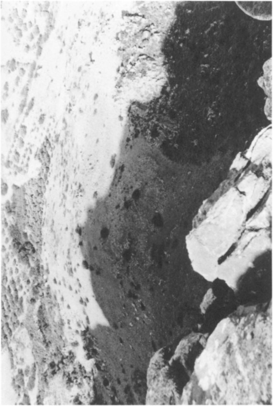
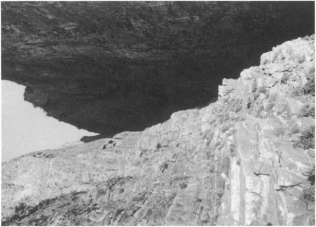
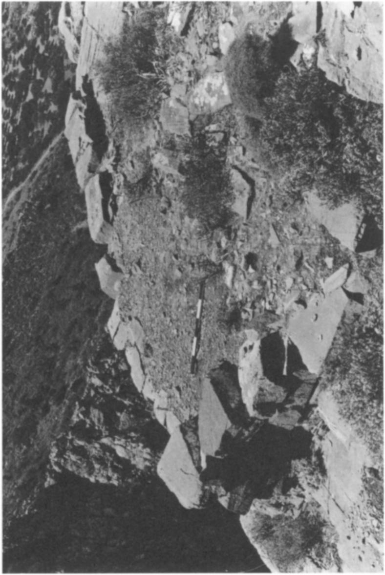
16 318 DONALD C. HAGGIS AND KRZYSZTOF NOWICKI 43. Base fragment of pithos Diam Coarse fabric Type X. Base slightly beveled with finger-impressed band. 44. Base fragment of pithos Diam. >0.30. Coarse fabric Type X. Beveled base. 45. Tripod foot fragment Max. pres. H ; Diam Coarse fabric Type IV Finger impression at top. 46. Tripod foot and base fragment P1. 69:c Max. pres. H ; Diam. foot Finger impression at base. 47. Tripod foot fragment Max. pres. H. 0.04; Diam Coarse fabric Type IV Finger impression at top. KATALIMATA The settlement of Katalimata (or Kato Katalimata) lies opposite Khalasmeno on several ledges that overhang the mouth of the Kha gorge on its north side (Figs. 3, 8-1 1; P1. 68:a, 68:c at 2). From the isthmus one sees the deep and dramatic crevasse of Kha, which separates the mountains of Papoura on the north from the massif of Lamia on the south; from the vantage point of the lowlands nothing is visible today that might indicate the existence of built terraces in the gorge. The rock terraces of the settlement can be seen from above, from the top of the southern edge of the gorge (Figs. 10, 11; P1. 70:b, d). The site is also visible from the heights of Khalasmeno, some meters to the south. The house walls of Katalimata, built of the same local gray crystalline limestone as the surrounding rock, are indistinguishable from the vertical stepped terraces that form their backdrop. The limestone of the Papoura cliff on the north face of Kha is naturally stratified in horizontal layers. These layers are divided by fissures and have the appearance of artificial courses of stone. The extant walls of the settlement are constructed with this local limestone, which breaks naturally at the intercalations of calcium carbonate. These fracture lines permit the quarrying of single, boulder-sized blocks for wall foundations, thresholds, orthostates, and door jambs (e.g., P1. 71 :d, f). As at Khalasmeno, walls were built with either dry-stone construction or mud mortar. Interior and exterior house walls are double faced, although single, large stones often span the width of the walls, creating a "header and stretcher" appearance. Katalimata consists of three distinct areas of building (Fig. 8; P1. 70:b): the upper settlement (Buildings A-C), the middle settlement (Buildings E-K), and the lower settlement (Building L). These groups of buildings are situated on no less than eight separate bedrock terraces covering an area of 0.35 ha. and climbing to a height of 65 m. from the lowest terrace to the highest (Fig. 9). The only access into the site is at the elevation of area E and consists of a narrow ledge leading high along the west-facing cliff of Papoura (Figs. 8, 11). This ledge can be reached only from the base of the gorge on the north side. One ascends a steep embankment of scree from the mouth of the gorge, ca m. (ca. 20-minutes walk) in a northeasterly direction along the west face of the Papoura cliff. It is not unlikely that when Khalasmeno and Katalimata were inhabited, some kind of path or even kaldenimi was
.")
17 KHAIASMENO AND KATALIMATA: TWO EARLY IRON AGE SETTLEMENTS 319 'tuw~~~~~~~~~~~~~~~~~~~~' 'x7 V V NG m KN, DH 1990 FIG. 8. Plan of Katalimata utilized. There is some evidence for a stone-built path slightly above the base of the scree line, immediately northwest of the mouth of the gorge (Fig. 10, bottom, at 1). The date of this small segment of path and even its identification as a kalderimi are uncertain. THE ENRy ' PATH AND GATE The route up the loose scree from the base of the Papoura cliffclimbs to about 200 meters above sea level and then turns sharply onto a ledge (ca. 1-2 m. wide), which is traversed in a southerly direction (Figs. 8, 10; P1. 70:a, c). This ledge is only one of many similar lateral
18 320 DONALD C. HAGGIS AND KRZYSZTOF NOWICKI A C~~~~~~~~~~~~~~~~~~~~~~~~~~~~~~~~~~~~~ J = --8 ~L - 50 m 50m0 FIG. 9. Sectilon of Katalimata from east shelves in the nearly vertical west cliff face. The entrance path to the settlement runs along the ent'ire west face of the mountain front to the mouth of the gorge, whereas the other shelves terminate in a rock wall or precipice. This access path (or "Entry Path") follows the bedrock ledge for a distance of about 40 meters until it reaches a cleft in the rock (ca m. wide), which has been worked and built with three steps (Figs. 8 and 10 at N; P1. 71 :a). This cleft or crevice is most likely a natural feature that was included in the defensive arrangement of the settlement. The rock may have been slightly hewn out and the steps added to transform the passage into a defensible "gate". It is equally likely that since this is the only possible access to the settlement, the crevice was merely widened to facilitate passage at this point along the path. Similar "gates", however, appear in the north cliff of Karphi and in the citadel of Gon'ies Porolios, both LM IIIC in date.2 Direcdly above this gate, on a small terrace to the west, is a concentration of potsherds and wall tumble that may represent a building of some kind (Building N, Figs. 8, 1 0). The 29 Pendlebury, Pendlebury, and Money-Coutts , p. 72.
19 KHALASMENO AND KATALIMATA: TWO EARLY IRON AGE SETTLEMENTS 321 KHA i)i ~~GORGE y, FG 1 at K wall~ of a~'j; lins sqe renotviibe rq 2 o te urfce bttec * i,9w,i,^y:x Yt I Ar ' 1'rV 'tb. I4; wallle aroter unot visil lthle on surfae, buth sothwesiz of the terace penrmipts reontuctdiongm Figs. 8, 10). Here the ledge is wider, and linear stone accumulations suggest wall lines. 30 Pendlebury, Pendlebury, and Money-Coutts , p. 73.
20 322 DONALD C. HAGGIS AND KRZYSZTOF NOWICKI /'1' EPANO ' KATALIMATA 1 / D C S ) W! FIG. 11. Katalimata from southwest Although the plan of the building could not be determined, we can say that in contrast to Building N, unit M is a proper house. The ledge for the next m. is no wider than 1.5 in., and there is no space for any building.
. Some 2 meters above the Entry Path at the branch, there is a natural terrace (2 x 10 m.")
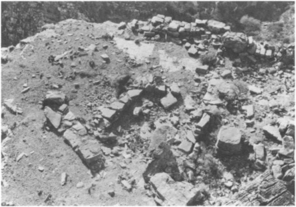
21 KHALASMENO AND KATALIMATA: TWO EARLY IRON AGE SETTLEMENTS 323 Shortly before the Entry Path reaches the mouth of the Kha gorge, it branches to the east, and a steep ascent allows access to a stepped cliff leading to the upper part of the settlement (P1. 71 :b). Some 2 meters above the Entry Path at the branch, there is a natural terrace (2 x 10 m.) that served as a platform of a long house squeezed between the edge of the terrace and the cliff (Building D). The long west wall of Building D is still preserved along the west edge of the terrace, and traces of short north and south walls are visible (Figs. 8, 13; P1. 71 :b). The entrance to Building D is at the north, that is, from the point of the branch in the Entry Path. THE UPPER SETTLEMENT (BUILDINGS A-C) Building C is not only the best preserved but the largest and best-situated house at the site (Figs ; P1. 71 :c, e). It occupies most of an extensive terrace ca. 18 m. above the Entry Path. The only access to Building C is a path that leads from the Entry Path up a stepped cliff and terminates in a rock-cut stairway on the southwest side of the Building C terrace. The shape of this terrace and the exigencies of the terrain necessitated the curving of the south-southeast wall of the structure (Figs. 12, 14; P1. 71 :c). Building C is situated so as to leave space for communication along the south and east sides of the terrace and to allow safe access to the other parts of the settlement. Although severely eroded, the line of the southeast wall can be reconstructed as running between the preserved southeast corner and the south end of the west wall, just north of the entrance to the terrace (Fig. 13). The house extended to the edge of the terrace along the west side and as far as the base of the cliff on the north. The northeast corner has been obscured by boulders that have fallen from the cliffs above. Since there is no evidence of a wall line under the fallen debris, it is possible that some of the boulders in this area were incorporated into the plan at the northeast corner (Fig. 12: rooms 5 and 7; P1. 71 :c). The total size of the house is 12 m. (north-south) by 7 m. (east-west). The internal area can be calculated as sq. m. Building C consists of seven rooms. The only possible entrance is in its southwest corner, just east of the stepped passage onto the terrace. Although this part of the wall is nearly completely destroyed, the reconstruction of the south wall (Fig. 13) is plausible. The possibility exists, however, that rooms I and 2 were only partially enclosed and roofed, as the extant plan might suggest. The completely exposed bedrock in room 1, while a characteristic of a number of Early Iron Age houses, is in marked contrast to rooms 2, 3, and 4, in which clay-floor and ceiling debris remain to a depth of at least 0.10 Im., in spite of the extreme erosion on the cliff terraces. Such an exposed surface might suggest a hypaethral arrangement, possibly a porch or courtyard. Room I has three openings, leading to two rooms on its east (rooms 2 and 3) and one to the north (room 4). Room 3 has a preserved doorway on the west, but the exact shape of room 2 and the location of its entrance are uncertain. Since the reconstructed wall and doorway (Fig. 13) between rooms I and 2 are conjectural, it is possible that room 2 was simply an extension of the courtyard to the west (room 1). Room 4 may be a vestibule or corridor linking rooms 2 and 3 with rooms 5-7. The main living room seems to have been room 5, which has well-preserved west and south walls. The north and east walls of the room are suggested by the boulders (Fig. 12:
22 324 DONALD C. HAGGIS AND KRZYSZTOF NOWICKI C)(I c' 3Q - -_ 5 5m FIG. 12. Katalimata: plan of Building C rooms 5 and 7), which may have been incorporated into the foundations of the building. A doorway in the party wall of rooms 4 and 5 has a well-built threshold, and the north door jamb consists of a single slab of limestone standing over a meter in height (Fig. 12; P :d). Room 5 is the largest and most elaborate of the rooms of Building C. The interior space measures over 9 sq. m. (ca. 3 x 3 m.), and near the center of the room is a pillar formed by three stacked and dressed blocks. While the pillar is not a necessary architectural element, given the size of the room, it may have been added as a support for a long crossbeam
f Path totraces aogtees and by the boulders.")
23 KHALASMENO AND KATALIMATA: TWO EARLY IRON AGE SETTLEMENTS 325 ~~~~ 3 42~~~~ B (view from southwest)~~~1(1 ' ~ perhaps~~~'ll 2Kann/n rom n.atog h ot atotebidn smr iti o FI.1.Ktlmt:reconstruct,tesaeion ofl Bufiledialngs CtndDhrue fromh Enty (EP)f Path totraces aogtees and by the boulders. The two rooms here (6 and 7) may have been divided into smaller units. Rooms 5, 6, and 7 contain a dense cover of stone tumble and clay, rendering surface collection
24 326 DONALD C. HAGGIS AND KRZYSZTOF NOWICKI 2 5 B 0 5m FIG. 14. Katalimata: section of the terrace of Building C from east

25 KHALASMENO AND KATALIMATA: WO EARLY IRON AGE SETTLEMENTS 327 of pottery impossible and attribution of function speculative. The size and construction of room 5 suggest a living/sleeping area. The orientation and size of 6 and 7 might indicate rear storage rooms separated from the main sleeping area but accessible from room 4, a corridor or vestibule. Pottery was most abundant in rooms 3 and 4, and storage and cooking functions seem most likely in those areas. A single pithos scatter in room 3 suggests a storage function. The conspicuous absence of pottery in rooms 1 and 2 argues for their use as animal or fodder storage or as external living areas. The path that ascends to the terrace of Building C continues east and then north around the edge of the house and conforms to the limitations of the terrace. At the northeast side of Building C, the path turns east and climbs 9 meters to another terrace, where there is evidence for further building (Fig. 8 at B). There are no easily distinguished walls preserved here, but the concentration of pottery, the shape of the terrace (ca. 30 m. long x 6 m. wide), and the stone tumble suggest the existence of houses. East of this terrace there is a light scatter of pottery, but the steep, sloping terrain, lack of wall remains, and dense stone overburden preclude specific interpretation. This area might have been used as a quarry for the building materials used in the settlement or as a temporary refuge for flocks. At the highest elevation in the settlement are traces of architecture that occupy a rocky terrace ca. 8 x 6 m. (Fig. 8 at A). The extant remains allow a reconstruction of a small rectangular building (Building A) measuring 2 x 2.5 m. The only access to this terrace is from a stepped slope just east of terrace B. The situation of Building A is well suited for a watch point. The range of view from the location covers the entire west, northwest, and northeast area of the lerapetra isthmus (as far as 18 degrees) and the bay of Mirabello; included in this view is a large portion of the plain of Kavousi and the bay of Tholos. Building C and Khalasmeno are visible to the south. THE MIDDLE SETTLEMENT (BUILDINGS E-K) The main concentration of houses at Katalimata was situated in the middle part of the settlement (Figs. 8 and 10 at E-K; P1. 72:a, b), which is connected directly with the main Entry Path south of Building D at terrace E. The extant portion of Building E is the southwest corner, where the Entry Path turns sharply east into the Kha gorge proper. Since the terrace of Building E is the only access to the middle (Fig. 8 at E-K) and lower (at L) parts of the settlement, either Building E did not occupy the whole space between the inner edge of the terrace and the cliff or the house was simply traversed by the main communication line.31 A narrow passage between the house and the cliff on the north side seems the most plausible; no certain house plan, however, could be distinguished. East of Building E is a wide natural terrace extending about 75 meters eastward into the gorge. At least three architectural units with associated concentrations of pottery were identified here (Fig. 8 at F, G, and H). The best-defined walls are visible at G, where a rectangular house of medium size (ca. 5 x 3 m.) stood against the cliff. A similar arrangement is suggested for Buildings F and H, although only wall traces are visible. While concentrations of sherds appear clustered at locations F, G, and H, it is possible that this is a result of uneven erosion and does not preclude other houses occupying this long terrace. 31 A similar situation of a house communication line is room 113 at Karphi.
. Its outer walls, like the west wall of Building C, were built exactdy along the cliff edge. The foundations (P1.")
26 328 DONALD C. HAGGIS AND KRZYSZTOF NOWICKI Another well-defined unit is Building I, some 2.5 m. below E (Fig. 8; P1. 72:a). Like Building E, this house occupied its own terrace (ca. 40 sq. m.). Its outer walls, like the west wall of Building C, were built exactdy along the cliff edge. The foundations (P1. 72:c, d) are three courses of limestone boulders, and the upper course is double faced, employing both small fieldstones and large limestone slabs. The terrace of Building I is situated on the most convenient route to the lower settlement, and although the complete plan of the house is impossible to determine, the route to terraces K and L was most likely squeezed between Building I and the cliff face. AtJ, there is only a supporting wall (perhaps a retaining wall or balustrade), which borders the terrace on the south. This wide terrace yielded some potsherds, but no architectural plan could be distinguished. At K, further east of terracej, are wall remains indicating one or two houses, filling the width of the terrace. A rock-cut bin (P1. 73:b) and saddle quern (P1. 73:a) were among the features of Building K. THE LOWER SETTLEMENT (TERRACE L) The lowest part of the settlement (terrace L) lies about 18 meters below Building K and some 45 meters below Building C (Figs. 8, 9). The north side of terrace L is contained by a steep slope of bedrock terraces reaching a height of over 4 meters. The south side of the terrace is a vertical incline, dropping at least 70 meters into the bottom of the Kha gorge (Figs ). No certain buildings were identified in terrace L, but the abundance of sherds and stone blocks suggests that several houses may have stood along its 30-meter length.32 ARCHITECTURAL SUMMARY The settlement of Katalimata is composed of at least ten units that may represent houses or house clusters. These are Buildings B-I, K, and M. Buildings A and N may have served as a watch point and guardhouse, respectively. The maximum number of houses is difficult to determine, as terraces B, F, G, H, K, and L may have been occupied by more than one house. Houses range in size between 20 and 80 sq. m., and while generally smaller than at Khalasmeno, it is possible to estimate between 10 and 15 house units at Katalimata. The total area of the settlement is about 0.35 ha., that is, about half the size of Khalasmeno. Considering the extreme limitations of the topography, the houses located in the elongated terrace B and in terraces D-L most likely had axial plans with doorways on the short walls. Three parts of the settlement have been distinguished. The Entry Path leads the visitor first past Building D to the middle settlement, consisting of Buildings E-I. Above this middle terrace and more inaccessible is the upper settlement, composed of Buildings A-C. In respect to topography and size, Building C is the most important structure in the settlement. The house occupies the widest and most discrete terrace and enjoys a view of not only the entire middle and lower settlement but the whole of the north Isthmus of lerapetra. Building C controls access to terrace B and the extensive area to the east, which could easily have been a quarry or shelter for stocks of sheep and goat. Finally, the lower settlement, or terrace L, because of its proximity to the gorge, may have been associated with supplying water for the inhabitants. 32 According to Manolis Zigakis of Vasiliki, a worked stone, once situated at the south edge of the terrace, was used for drawing water from the pools at the bottom of the gorge.
 and Epano Katalimata.")
27 KHALASMENO AND KATALIMATA: TWO EARLY IRON AGE SETTLEMENTS 329 EPANo KATALIMATA While only one location at Monastiraki bears the name Katalimata in the archaeological record,33 local inhabitants mention two sites with this name: Kato Katalimata (Katalimata proper) and Epano Katalimata. The word katalimata itself is very common in Crete for ruined walls or house remains, but it may also describe natural formations. According to Monastiraki residents, Epano Katalimata was afrourio (look-out post) during the Turkish occupation; the site is variously described as a wall or building but never as a group of buildings or an ancient settlement. Epano Katalimata appears at the top of the highest bedrock terrace on the north edge of the Kha gorge, when viewing the gorge from the northwest (Fig. 11; P1. 68:b). The site consists of a limestone shelf, the southern part of which drops abruptly into the gorge. A wall, some 6 to 7 meters long and preserved to 2.5 meters in height, forms a border to this terrace on the north, but no certain building plan can be determined from the extant remains. Although the building material (local gray limestone) and dry-stone construction are the same as observed at Katalimata, the complete lack of pottery precludes dating of the wall. Epano Katalimata is most easily reached from the Papoura scree line, north of the entrance to Katalimata; located about 150 meters above Katalimata proper, the site might have served as a watch point for the settlement below. Certainly it could not have been a mandra, for the general topography and extreme isolation of the site preclude such an interpretation. THE POTTERY The pottery from Katalimata is primarily LM IIIC with the exceptions of cup fragments 57, 58, 59, and 69 (Fig. 15), which are Middle Minoan (MM) IB-II. 58 and 69 are typical MM conical cups, 59 is a tumbler, and 57 is a large carinated cup. Middle Minoan remains are not uncommon at LM IIIC locations, such as Vrokastro, Karphi, Vronda, and Kastri, and the evidence from Katalimata offers further evidence for this interesting pattern.34 Sherds 54 and 55 (Fig. 15; P1. 73:c), one with a dotted curvilinear decoration, possibly a spiral, and the other with a wavy line, are easily LM IIIC, as is the scale pattern on sherd 56 (P1. 73:c).35 The deep-bowl base with the reserved disk 68 (Fig. 15) and stemmed-cup foot 66 (Fig. 15) suggest an LM IIIC date, and the pyxis base with the beveled edge 65 (Fig. 15) is similar to an example from Kastri.36 The separate stirrup-jar disk with a depression at the top may indicate an attempt at piercing for an air hole (70; Fig. 15, P1. 73:d); the separate false-spout disk has been noted as an LM IIIC feature at both Kastri and Karphi. The large, coarse stirrup jar 88 (Fig. 16; P1. 73:d) is also a type common at Kastri and Karphi.37 Jars are prevalent coarse-vessel types (73; Fig. 15), as are tripod feet with a round section (81, 92; Figs. 15, 16). Common at both Katalimata and Khalasmeno are pithos fragments with 33 See note 3, p. 305 above. 34 Snodgrass 1971, p. 37; Day, Coulson, and Gesell 1986, p. 386; Hall 1914, pp. 89, 115. At Kastri (Sackett and Popham 1965, p. 278), the excavators insist that the MM-LM IIIA sherds at the site are not stratigraphically significant but represent "content of LM IIIC mudbrick." 35 An LM IIIC stirrup jar from Malia contains dotted spirals or argonauts, Kanta 1980, p. 51, pl. 22:4; for the wavy line, see Popham 1965, p. 24 and Sackett and Popham 1965, p Sackett and Popham 1965, p. 289, fig. lo:j. 37 Popham 1965, p. 320; Sackett and Popham 1965, p. 284; Seiridaki 1960, p. 16.
28 r 330 DONALD C. HAGGIS AND KRZYSZTOF NOWICKI ~~49 5?- -5- )( ; p -t * 77 t _ J KATALIMATA cm FIG. 15. Katalimata: fine and coarse ware
29 KHALASMENO AND KATALIMATA: TWO EARLY IRON AGE SETTLEMENTS ,~~~~~~~~~~~ ~~~~~~~~~~~~~~~~KATALIMATA 91 ~ ~~~~~0 ~ 5kcm FIG 16 Katalimata: coarse ware incised hatching or chevrons ( Fig. 16). Such incised decoration is the norm at Vronda, Karphi, and Kastri. CATALOGUE FIGURES 15, Rim fragment of basin Diam Buffclay, light yellowish brown slip (I OYR 6/4). Trace of black paint on exterior. Wide black band on rim interior. 49. Rim fragment ofjar Diam.? Pink clay, buff slip, fine black and white, gritty inclusions. 50. Rim fragment ofjar Diam Pink clay, buff slip, fine black and white inclusions. Black-brown paint on exterior (5YR 5/2). Trace of black paint on interior. 38 Day, Coulson, and Gesell 1986, p. 373; Seiridaki 1960, pp. 3-4, pls. I:a, 12:a; Sackett and Popham 1965, p. 286, pl. 78:c; Hall 1914, p. 91.
30 332 DONALD C. HAGGIS AND KRZYSZTOF NOWICKI 51. Rim fragment ofjug Diam Soft buff clay (1OYR 7/4), traces of slip (1OYR 8/3). 52. Rim fragment of cup or bowl Diam Buffclay (7.5YR 7/6), self-slipped, tiny, sparse phyllite inclusions. 53. Rim fragment of cup or bowl Diam Clay is burnt reddish brown (5YR 5/4). 54. Wall fragment of closed shape P1. 73:c Th Reddish buff clay (7.5YR 7/6), thick buff slip. Surface hard and burnished. Lustrous dark gray-black (7.5YR N 4/) painted linear decoration with dots on exterior. LM IIIB/C 55. Wall fragment of closed shape P1. 73:c Th Buff clay (reddish yellow: 7.5YR 7/6), thick buff slip (IOYR 7/4). Black paint (same as 54) on exterior. Wavy line in between horizontal lines above curving band. 56. Wall fragment of closed(?) shape P1. 73:c Th Buff clay, buff slip, tiny, dark grit inclusions. Blackpainted linear decoration on exterior; possible scale pattern. 57. Wall fragment of carinated cup or bowl Th Self-slipped brown clay (7.5YR 6/4), fine sandy grits and granodiorite inclusions (coarse fabric Type IH/VI). MM IB-II 58. Base fragment of conical cup Diam Pink clay, buff slip, tiny dark inclusions. MM IB-Il 59. Base fragment of straight-sided cup or tumbler Diam Buff clay, white grit inclusions. Traces of metallic black paint on interior. MM IB-II 60. Base fragment of cup Diam Orange clay (reddish yellow: 5YR 7/8), self-slipped. Base slightly beveled. 61. Base fragment of conical cup Diam Fine porous red clay, small, dark grit inclusions. Base slightly beveled. 62. Base fragment of basin Diam.? Medium coarse fabric Type XI. Pronounced wheel ridging on interior. 63. Base fragment of closed shape Diam Buff clay, pink core. Traces of black paint on exterior. 64. Base fragment of open shape Diam Pink clay (reddish yellow: 5YR 6/6), buff slip interior/exterior. Slip exterior very pale brown (IOYR 7/4); interior is pink (7.5YR 8/4). Black-painted rectilinear decoration on exterior. 65. Base fragment of straight-sided pyxis Diam.? Buffclay and slip interior and exterior. Pink core (light reddish brown: 2.5YR 6/4). Traces of black-paint exterior (dark gray: 2.5YR 4/0). LM IIIC 66. Foot fragment of stemmed goblet or "champagne glass" Diam. est Reddish yellow clay (5YR 7/8), buff slip (7.5YR 7/6). 67. Fragment of ring base of krater or bowl Diam Fine, soft orange clay with tiny white inclusions. 68. Base fragment of deep bowl Diam Pink clay, buff slip. Hollow at bottom of base. Red paint on interior with reserved disk at interior bottom. LM IIIB/C
31 KHALASMENO AND KATALIMATA: TWO EARLY IRON AGE SETTLEMENTS Base fragment of conical cup Diam Pink clay, buff slip. Base is string-cut at bottom. MM IB-II 70. Stirrupjar disk P1. 73:d Diam Orange clay, buff slip, large phyllite inclusions. Disk has depression in center top and bottom. LM IIIC 71. Rim fragment of pithos Diam.? Coarse fabric Type X. 72. Rim fragment of pithos Diam.? Coarse fabric Type XIV. 73. Rim fragment of cooking pot or jar Diam Coarse fabric Type IV. 74. Rim fragment ofjar Diam.? Coarse fabric Type IW 75. Rim fragment of pithos Diam.? Coarse fabric Type XV Brown slip exterior. Black band on exterior and trace of black paint on interior. 76. Rim fragment of basin Diam. >0.18. Coarse fabric Type XIV 77. Rim fragment of basin Diam.? Coarse fabric Type XIV 78. Rim fragment of pithos Diam.? Coarse fabric Type IV 79. Rim fragment ofjar Diam.? Coarse fabric Type IV. 80. Rim fragment of basin or jar Diam. 0.34? Coarse fabric Type X. 81. Fragment of tripod foot Diam Coarse fabric Type XIV 82. Base fragment of pithos or pithoid jar Diam Coarse fabric Type XVI. Base is slightly beveled. 83. Base fragment of pithos Diam Coarse fabric Type IV 84. Base fragment of pithos or pithoid jar Diam.? Coarse fabric Type IV Base is slightly beveled. 85. Rim fragment of pithos Diam Coarse fabric Type IV Black paint on exterior. 86. Rim fragment of pithos Diam.? Coarse fabric Type XIII. 87. Base fragment ofjar Diam Coarse fabric Type IV. 88. False spout and handle of stirrup jar P1. 73:d Diam. disk 0.068; max. pres. H Porous, greenish white clay (2.5YR 8/2-8/4), dense phyllite inclusions. Hollow false spout. 89. Wall fragment of pithos Th tiny, Coarse fabric Type X. Applied curving band with vertical incised hatching. 90. Wall fragment of pithos Th Coarse fabric Type XV Raised band with incised chevrons. 91. Wall fragment of pithos Th Coarse fabric Type X. Incised chevrons. 92. Foot fragment of tripod Diam Coarse fabric Type IV

32 334 DONALD C. HAGGIS AND KRZYSZTOF NOWICKI CONCLUSIONS The settlements of Khalasmeno and Katalimata are LM IIIC in date, and there is no evidence in the surface pottery that might suggest different phases of the period. The location of the sites, within 300 meters of each other, indicates that each exploited the same areas of land, most likely in the plain of Monastiraki, which extends south of the Kha river past Monastiraki village and west as far as Vasiliki Kephala. Given the proximity of the sites, their equivalent population size, date, and local catchment area, Khalasmeno and Katalimata may have represented a "dual-settlement" system in which the former site was a permanent habitation location and the latter a temporary place of refuge. Khalasmeno and Katalimata occupy distinctly different types of terrain within the same physical environment of the lower catchment area of the Kha river. Khalasmeno, situated on a low hill, is easily accessible from the plain of Monastiraki, where arable land and water are plentiful. Conversely, Katalimata communicates easily with neither the plain nor the mountainous hinterland; it is isolated and nearly inaccessible. Khalasmeno occupies a flat hilltop of some 0.65 ha., which is composed of about 12 contiguous house units; the ground area covered by architecture is ha. In contrast, Katalimata contains a roughly equal number of domestic units (10-15) while covering an area of 0.35 ha., only ha. of which is actually architectural space. Thus, Katalimata conforms itself to a topography which is not conducive to flock or field maintenance, water acquisition, communication within the settlement, settlement expansion, or even healthy population development. The contrasting topography and similar population capacities might indicate that the inhabitants of Khalasmeno exploited the naturally defensible features of Katalimata to establish a settlement capable of containing its population and perhaps flocks but for limited periods of time. Such a dual-settlement system is not unknown in Early Iron Age Crete. While many lowland and coastal areas of Crete remained inhabited after the destructions and abandonments of LM IIIB, a number of settlements were founded in LM IIIC.39 The characteristic topographic features of these new sites are their inaccessibility and defensible terrain or architecture.40 Sites such as Tapes Kastello, Kritsa Kastello, Kalamafka Kastello, Asari, the Kastro, Tourloti Kastri, and Vrokastro in Mirabello and Ierapetra are examples of sites that, like Karphi, either exploited a mountainous hinterland or were at least isolated from the coast.41 Further, there are some settlements of LM IIIC date that occupy a diverse topography, requiring habitation in separate areas, which are essentially two parts of the same settlement unit. For example, Vrokastro, Oreino Kastri, Gonies Porolios, and Arvi Fortetsa consist of two parts, and often the terms "upper" and "lower" settlement have been used to describe distinct areas of such sites.42 The division of the settlement into parts is most likely 39 Desborough 1972, p. 112; Hayden 1988, pp. 2, 21; Kanta 1980, p. 326; Popham 1965, pp Hayden 1988, p. 21; Nowicki 1987c, p Nowicki 1987c, pp Hayden 1983, p. 367; Gesell, Day, and Coulson 1985, p. 327; Nowicki 1987c, pp ; the terms "upper" and "lower" settlement are frequently used to facilitate the description of a single site that occupies a diverse topography.

33 KHALASMENO AND KATALIMATA: TWO EARLY IRON AGE SETTLEMENTS 335 the result of the limitations of the topography; that is, the physical terrain of the settlements requires habitation expansion into areas that might not be immediately contiguous. The dual-settlement system represented by Khalasmeno and Katalimata is different from the examples mentioned above and has few published parallels. This system fits the topographical criteria for neither the "upper" and "lower" settlements at Vrokastro,43 which are clearly parts of the same settlement, nor the Ano/Kato system defined by Bintliff.44 The Ano/Kato system requires the settlements to be located in different ecological or agricultural environments that are exploited seasonally or in response to population or economic pressure. In contrast, the "dual settlement" system may be defined as two separate sites of equivalent date and population capacity, which occupy the same environment (within 0.5 km.) but are situated in such topographically diverse locations as to suggest functional differences. The low hill of Khalasmeno is in close proximity to water and arable land and is thus exposed to the Isthmus of Ierapetra and the Bay of Mirabello. Such a position might have necessitated the foundation of a second settlement that was defensible from the west and could accommodate the population, storage provisions, and livestock in times of threat.45 Such a site is Katalimata, whose topography shows that it existed within the same agricultural environment as Khalasmeno but is clearly isolated from the lowland plains of Kamina and Monastiraki. The sites at Ellinika in the Zakro gorge, a pair of sites at Mythi, west of Ierapetra (Ellinika and Kastello), and the settlements at Koutsounari Karphi might be examples of this dual-settlement system, where one site is accessible to an agricultural hinterland, while the other is somewhat isolated.46 These sites are not published adequately enough to affirm completely the comparison; the topographical criteria established by Katalimata and Khalasmeno, however, might provide a basis for reanalyzing LM IIIC settlements. In the area of Kavousi, the Early Iron Age settlement pattern consists of several nucleated sites founded in LM IIIC or in the later stage of LM IIIB. The main sites, Vronda and Kastro, are situated near agricultural terraces and perennial springs.47 While the locations of these settlements are naturally defensible from the Kampos plain (Fig. 2), the conditions that led to their foundation remain controversial48 and are still under study. A return to a subsistence economy in LM IIIB, after the dissolution of the Minoan palatial and post-palatial economic 43 Hayden 1983, p Bintliff 1977, p Hayden (1988, p. 21) suggests a storage function for Almyrou Kastrokefala. 46 For Ellinika Zakro, see Mariani 1895, p. 293; Hogarth ; Pendlebury, Eccles, and Money-Coutts , p. 98; Platon For Ellinika and Kastello at Mythi, see Hayden 1988, pp For Koutsounari Karphi, see Nowicki Vronda and Kastro are located near two perennial springs at Xerambela and Agios Niketas. The agricultural terraces in the immediate area of the two settlements are productive today, even in dry summer months and without irrigation; they appear to have been the favored agricultural land in the Kavousi area. Recent survey on the Kavousi terraces has recovered buildings and in situ sherd scatters of Bronze Age date, suggesting continuous use and maintenance of the hill slopes certainly from MM I. Extensive Minoan agricultural terracing has been studied at nearby Pseira; see Hope-Simpson and Betancourt The authors disagree on the events that caused the changes in settlement patterns at the end of LM IIIB and the beginning of LM IIIC. For one interpretation, see Nowicki 1987a, p. 250; Nowicki 1987b; Nowicki 1987c, pp ; and Nowicki 1990.

34 336 DONALD C. HAGGIS AND KRZYSZTOF NOWICKI systems, might require settlement nucleation and concentration in agriculturally productive areas; at Kavousi these areas are possibly the mountain regions of Vronda and Kastro.49 If defensibility was a primary or added concern, then Katalimata and Khalasmeno are representative of this dual function in Early Iron Age settlements. While sites of LM IIIC date, such as Vronda and Kastro, are both defensible and situated in well-watered, agricultural areas, Khalasmeno is exposed to both land routes and sea routes; the siting of the settlement was clearly to allow easy access to water and the fertile plain. The specific cause of the threat that might have led to the foundation of the neighboring Katalimata remains uncertain. The instability of Crete following the destructions of LM IIIB, however, led to the formation of new settlements which were situated to exploit the topographical diversity of Crete for a variety of needs. BIBLIOGRAPHY Betancourt, P. P Cooking Vesselsfrom Minoan Kommos: A Preliminary Report, Los Angeles Bintliff, J. L Natural Environment and Human Settlement in Prehistoric Greece (BAR Supplement, ser. 28, 1), Oxford Boyd, H. A "Gournia: Report of the American Exploration Society's Excavations at Gournia, Crete, ," in Transactions of the Department ofarchaeology: Free Museum of Science andart Universit of Pennsylvania I, i, pp Day, L. P "Early Iron Age Architecture at Kavousi," in Proceedings of the Sixth International Cretological Congress A2, Chania, pp Day, L. P., W D. E. Coulson, and G. C. Gesell "Kavousi, : The Settlement at Vronda," Hesperia 55, pp Day, L. P., and K. T. Glowacki "Spatial Analysis of a Late Minoan IIIC/Subminoan Domestic Complex in Eastern Crete" (lecture, New Orleans 1992), abstract in AJA 97, 1993, p. 349 Desborough, V R. d'a The Greek Dark Ages, London Gesell, G. C., W D. E. Coulson, and L. P. Day "Excavations at Kavousi, Crete, 1988," Hesperia 60, pp Gesell, G., L. Day, and W Coulson "Excavations and Survey at Kavousi, ," Hesperia 52, pp "Kavousi : The Kastro," Hesperia 54, pp "Excavations at Kavousi, Crete, 1987," Hesperia 57, pp Haggis, D. C "Survey at Kavousi, Crete: The Iron Age Settlements" (lecture, San Francisco 1990), abstract in AJA 95, 1991, p "The Kavousi-Thriphti Survey: An Analysis of Settlement Patterns in an Area of Eastern Crete in the Bronze Age and Early Iron Age" (diss. University of Minnesota 1992) Haggis, D. C., and M. S. Mook "The Kavousi Coarse Wares: A Bronze Age Chronology for Survey in the Mirabello Area, East Crete," AJA 97, pp Hall, E. H Excavations in Eastern Crete: Vrokastro (University of Pennsylvania, The University Museum, Anthropological Publications III, iii), Philadelphia Hayden, B.J "The Development of Cretan Architecture from the LM IIIA through Geometric Periods" (diss. University of Pennsylvania 1981) 49 While the lowland plain of Kampos is exploited today for olives, intensive use of the rocky terra rosa soils is only possible because of extensive modern irrigation practices instituted since World War II. The statements made here on the relative agricultural potential of the various areas of Kavousi are based entirely on the authors' observations of the current and traditional agricultural practices in Kavousi, Thriphti, and the north Isthmus of Ierapetra. A study of the Kavousi soils is being conducted byj. T. Ammons, J. Foss, and M. Timpson of the University of Tennessee as part of the Kavousi Project.
35 KHALASMENO AND KATALIMATA: TWO EARLY IRON AGE SETTLEMENTS 337 * "New Plans of the Early Iron Age Settlement of Vrokastro," Hesperia 52, pp * "Crete in Transition: LM IIIA-IIIB Architecture, A Preliminary Study," SMEA 26, pp * "Fortifications of Postpalatial and Early Iron Age Crete," AA 1988, pp Hogarth, D. G "Excavations at Zakro, Crete," BSA 7, p. 145 Hope-Simpson, R., and P. P. Betancourt "Intensive Survey of Pseira Island, Crete" (lecture, Boston 1989), abstract in AJA 94, 1990, p. 322 Kanta, A The Late Minoan III Period in Crete (SIMA 58), Goteborg Mariani, L "Antichita Cretesi," MonAnt 6, pp McEnroe,J. C "Minoan House and Town Arrangement" (diss. University of Toronto 1979) Mook, M. S., and W D. E. Coulson "The Late Minoan IIIC Pottery from the Kastro Kavousi, East Crete" (lecture, New Orleans 1992), abstract in AJA 97, 1993, p. 351 Nowicki, K. 1987a. "The History and Setting of the Town at Karphi," SMEA 28, pp b. "Settlements of Refuge in Crete," Schrften des Deutschen Archdologen-Verbandes IX, pp c. "Topography of Refuge Settlement in Crete," jahrbuch des Rimisch-Germanischln Zentralmuseums, Mainz 34, pp "The West Siteia Mountains at the Turn of the Bronze and Iron Ages," Aegaeum 6, pp Pendlebury,J. D. S The Archaeology of Crete, London Pendlebury,J. D. S., E. Eccles, and M. B. Money-Coutts "Journeys in Crete," BSA 33, pp Pendlebury, H. W, J. D. S. Pendlebury, and M. B. Money-Coutts "Excavations in the Plain of Lasithi III. Karphi," BSA 38, pp Platon, N <<'Avoccxaccat Z&xpou>>, IIpax-Lx&a -g iv 'AO4vcLq 'ApXaLOXOYLXI 'EEaLpE{OX 1962, p. 167 Popham, M. R "Some Late Minoan III Pottery from Crete," BSA 60, pp Sackett, L. H., and M. R. Popham "Excavations at Palaikastro VI," BSA 60, pp Seiridaki, M "Pottery from Karphi," BSA 55, pp Snodgrass, A. M The Dark Age of Greece, Edinburgh Tim UNWvERsrrY OF NORTH CAROLINA AT CHAPEL HILL Department of Classics 212 Murphey Hall CB# 3145 Chapel Hill, NC INSTrruTE OF ARCHAEOLOGY AND ETHNOLOGY Polish Academy of Sciences Al. Solidarnosci Warsaw, Poland DONALD C. HAGGIS KRZYSZTOF NOWICKI


36 PLATE 68 kr~~~~~~~~~- xf0 1A In ~~~I co ~~~ ~S C0 c

 1, (2) 2, (3)")

 34, (3) 35,")

37 PLATE 69 f Khalasmeno a. Retaining wall at unit 13; from southeast ur.. 5 _ b. Fine ware: (1) 1, (2) 2, (3) 23, (4) 21, (5) 25, (7) 20. No. 6 is U U U U uncatalogued WIW d. 32: Terracotta plaque, back 4 6 c. Coarse ware: (2) 34, (3) 35, (5) 40, (6) 46. Nos. 1 and 4 are uncatalogued e. 32: Terracotta plaque, front


38 ; -l?'> '\-s-f ' PLATE 70 'd A ib~~~~~~~~~~~~~~~~~~~~~~~~~~~~~~ X.-.,^'. i 4 ' 2 ;@ ~~~~~b. Aerial view from south side of Kha gorge, showing locations of p. ~~~~~~~Buildings A and C.44~~~~~~~~~~~~~~~~~~~~~~~~~~~~~~~~~~~. r t,' ;a.9 a. Katalmata and Kha gorge from west: route up scree and Entry Path _ I~~~~~~~~~~~~~~~~~~~~~~~~~~~~~~~~~~~~~~~~~~~~~~~~~~~~~~~~~~ Katalimata bd. Aerial view from south I! c. ilew from south showing location of Building C and plain of Kavousi


39 PLATE 71 b. Entry Path; Building D in center a. "Gate" at unit N : c. Building C, aerial view from northeast d. Doorjamb and threshold of room 5, Building C 4-1~- ~~~~~~~~~~~ A'~~~~~~~~~~~~~~~~~~~~~~~~~~I e. Detail of Building C, from northeast f. South wail of room 5
")
40 PLATE 72 4.) ~~~~~~~~~~~~~~~~~~~~~~~~~~ 4. mou -,~~~~~~~~~~~~~~~~~~ ~~~~~~~~~~~~~~~bo.;s~~~~~~~~~~~~~~~~~~~~~~~~~~~~~~~~~~~~~~~~~~v cn ~ ~ O


41 a. Saddle quern in Building K Katalimata b. Rock-cut bin (center). P in Building K of Y~ c. Fine ware: 56,55, 53 d. Stirrup-jar fragments:8 D. C. HAGGIS AND K. NowIcKI: KHA4LAmmENo AND IKATALimATA: Two EMUXy IRON AGE SETTLEM
Trench 91 revealed that the cobbled court extends further to the north.
 Report on the 2013 Gournia Excavations The 2013 excavations at Gournia were conducted June 17 July 26 under the aegis of the American School of Classical Studies at Athens and the supervision of the KD
Jneneh in the Upper Wadi az-zarqa, in North Central Jordan, First Season 2011.
 Jneneh in the Upper Wadi az-zarqa, in North Central Jordan, First Season 2011. Khaled Douglas Jneneh is located in the north-western periphery of the city of Zarqa (grid ref. 250.88E 165.25N), in North
In 2014 excavations at Gournia took place in the area of the palace, on the acropolis, and along the northern edge of the town (Fig. 1).
.") Gournia: 2014 Excavation In 2014 excavations at Gournia took place in the area of the palace, on the acropolis, and along the northern edge of the town (Fig. 1). In Room 18 of the palace, Room A, lined
Gournia: 2014 Excavation In 2014 excavations at Gournia took place in the area of the palace, on the acropolis, and along the northern edge of the town (Fig. 1). In Room 18 of the palace, Room A, lined
The Greek-Swedish-Danish Excavations at Kastelli, Khania 2010 a short report
 The Greek-Swedish-Danish Excavations at Kastelli, Khania 2010 a short report During six weeks from 19 July to 27 August the Greek-Swedish-Danish Excavations continued work in the Ag. Aikaterini Square
IMTO Italian Mission to Oman University of Pisa 2011B PRELIMINARY REPORT (OCTOBER-DECEMBER 2011)
") IMTO Italian Mission to Oman University of Pisa 2011B PRELIMINARY REPORT (OCTOBER-DECEMBER 2011) The 2011B research campaign took place in the area around Salut from October, 19 th, to December, 16 th.
IMTO Italian Mission to Oman University of Pisa 2011B PRELIMINARY REPORT (OCTOBER-DECEMBER 2011) The 2011B research campaign took place in the area around Salut from October, 19 th, to December, 16 th.
Architectural Analysis in Western Palenque
 Architectural Analysis in Western Palenque James Eckhardt and Heather Hurst During the 1999 season of the Palenque Mapping Project the team mapped the western portion of the site of Palenque. This paper
IKLAINA ARCHAEOLOGICAL PROJECT 2016 FIELD REPORT Michael B. Cosmopoulos
 IKLAINA ARCHAEOLOGICAL PROJECT 2016 FIELD REPORT Michael B. Cosmopoulos Introduction The overarching objective of the Iklaina project is to test existing hierarchical models of state formation in Greece
4. Bronze Age Ballybrowney, County Cork Eamonn Cotter
 4. Bronze Age Ballybrowney, County Cork Eamonn Cotter Illus. 1 Location map of the excavated features at Ballybrowney Lower (Archaeological Consultancy Services Ltd, based on the Ordnance Survey Ireland
ISOM & ISSOM forbidden symbol comparison
 & forbidden symbol comparison Forbidden symbols and their relatives Symbol 2000 (Long, Middle) 2007 (Sprint) 201 Impassable cliff An impassable cliff, quarry or earth bank (see 106) is shown with a 0.35
The Tel Burna Archaeological Project Report on the First Season of Excavation, 2010
 The Tel Burna Archaeological Project Report on the First Season of Excavation, 2010 By Itzick Shai and Joe Uziel Albright Institute for Archaeological Research Jerusalem, Israel April 2011 The site of
FOUNDATIONS OF ARCHAEOLOGY A WALK IN VERNDITCH CHASE
 FOUNDATIONS OF ARCHAEOLOGY A WALK IN VERNDITCH CHASE 1. A Tale of two Long Barrows Long barrows were constructed as earthen or drystone mounds with flanking ditches and acted as funerary monuments during
E X C A V A T I O N O F T H E E A R L Y I R O N A G E S E T T L E M E N T A T A Z O R I A By Donald C. Haggis and Margaret S. Mook
 E X C A V A T I O N O F T H E E A R L Y I R O N A G E S E T T L E M E N T A T A Z O R I A By Donald C. Haggis and Margaret S. Mook Figure 1. B3500: Sondage from the east, showing Archaic cobble fill and
218 R. S. BORAAS AND S. H. HORN
 were able to show a sequence of ceramic corpora much more fully representative than those available from the occupation surfaces and structures higher on the mound. This ceramic series obtained from D.
oi.uchicago.edu TALL-E BAKUN
 TALL-E BAKUN ABBAS ALIZADEH After I returned in September 1991 to Chicago from Cambridge, Massachusetts, I began preparing for publication the results of 1937 season of excavations at Tall-e Bakun, one
Trail Phasing Plan. Note: Trails in the Clear Creek Canyon area (Segments will be finalized in the future to minimize wildlife impacts
 Note: Trails in the Clear Creek Canyon area (Segments 2 5 and a future JCOS connection) will be finalized in the future to minimize wildlife impacts Trail Phasing Plan P Parking 3 Easy Trail Intermediate
New Studies in the City of David The Excavations
 The 2013-2014 Excavations Israel Antiquities Authority The intensive archaeological work on the city of David hill during the period covered in this article has continued in previously excavated areas
Excavations in a Medieval Market Town: Mountsorrel, Leicestershire,
 Excavations in a Medieval Market Town: Mountsorrel, Leicestershire, by John Lucas Mountsorrel is situated 12 kms north of Leicester and forms a linear settlement straddling the A6, Leicester to Derby road.
ANNA MORPURGO-DAVIES GERALD CADOGAN A SECOND LINEAR A TABLET FROM PYRGOS
 ANNA MORPURGO-DAVIES GERALD CADOGAN A SECOND LINEAR A TABLET FROM PYRGOS In May 1975 a second broken Linear A tablet was found during study of the pottery from the Minoan country house at Pyrgos near the
CARLUNGIE EARTH HOUSE
 Property in Care (PIC) ID: PIC015 Designations: Scheduled Monument (SM90059) Taken into State care: 1953 (Guardianship) Last reviewed: 2004 HISTORIC ENVIRONMENT SCOTLAND STATEMENT OF SIGNIFICANCE CARLUNGIE
Remote Sensing into the Study of Ancient Beiting City in North-Western China
 Dingwall, L., S. Exon, V. Gaffney, S. Laflin and M. van Leusen (eds.) 1999. Archaeology in the Age of the Internet. CAA97. Computer Applications and Quantitative Methods in Archaeology. Proceedings of
IKLAINA ARCHAEOLOGICAL PROJECT 2012 FIELD REPORT
 IKLAINA ARCHAEOLOGICAL PROJECT 2012 FIELD REPORT Michael B. Cosmopoulos The sixth season of the Iklaina Archaeological Project was conducted for six weeks in June and July 2012. Τhe project is conducted
Lidar Imagery Reveals Maine's Land Surface in Unprecedented Detail
 Maine Geologic Facts and Localities December, 2011 Lidar Imagery Reveals Maine's Land Surface in Unprecedented Detail Text by Woodrow Thompson, Department of Agriculture, Conservation & Forestry 1 Introduction
ARDESTIE EARTH HOUSE HISTORIC ENVIRONMENT SCOTLAND STATEMENT OF SIGNIFICANCE. Property in Care no: 24
 Property in Care no: 24 Designations: Scheduled Monument (SM90021) Taken into State care: 1953 (Guardianship) Last reviewed: 2004 HISTORIC ENVIRONMENT SCOTLAND STATEMENT OF SIGNIFICANCE ARDESTIE EARTH
III. THE EARLY HELLADIC POTTERY FROM THE MASTOS IN THE BERBATI VALLEY, ARGOLID
 III. THE EARLY HELLADIC POTTERY FROM THE MASTOS IN THE BERBATI VALLEY, ARGOLID by JEANNETTE FORSÉN The Swedish investigations of the hillock Mastos in the western part of the Berbati valley, ca. 3 km south
ANNUAL REPORT: ANCIENT METHONE ARCHAEOLOGICAL PROJECT 2014 FIELD SCHOOL
 ANNUAL REPORT: ANCIENT METHONE ARCHAEOLOGICAL PROJECT 2014 FIELD SCHOOL Director(s): Co- Director(s): Professor Sarah Morris, Cotsen Institute of Archaeology, UCLA John K. Papadopoulos, Cotsen Institute
IKLAINA ARCHAEOLOGICAL PROJECT 2015 FIELD REPORT Michael B. Cosmopoulos
 IKLAINA ARCHAEOLOGICAL PROJECT 2015 FIELD REPORT Michael B. Cosmopoulos The 2015 season of the Iklaina project took place from June 1 to July 7. The project is conducted under the auspices of the Athens
Following the initial soil strip archaeology is sprayed up prior to planning and excavation
 Barton Quarry & Archaeology Over the past half century quarries have been increasingly highlighted as important sources of information for geologists, palaeontologists and archaeologists, both through
Archaeological Investigations Project South East Region SOUTHAMPTON 2/842 (C.80.C004) SU
 SU") SOUTHAMPTON City of Southampton 2/842 (C.80.C004) SU 4382 1336 125 BITTERNE ROAD WEST, SOUTHAMPTON Report on the Archaeological Evaluation Excavation at 125 Bitterne Road West, Southampton Russel, A. D
SOUTHAMPTON City of Southampton 2/842 (C.80.C004) SU 4382 1336 125 BITTERNE ROAD WEST, SOUTHAMPTON Report on the Archaeological Evaluation Excavation at 125 Bitterne Road West, Southampton Russel, A. D
archeological site LOS MILLARES
 archeological site LOS MILLARES Aerial view of the plain of Los Millares between the Rambla de Huéchar and the River Andarax The archaeological site of Los Millares is located in the township of Santa
Lordenshaw. What are cup & ring marks?
 Lordenshaw Lordenshaw hill has one of the largest clusters of ancient cup and ring marked stones in the UK. We ve chosen four interesting spots we d like to share with you. What are cup & ring marks? The
Excavations on the Kastro at Kavousi. An Architectural Overview
 World Languages and Cultures Publications World Languages and Cultures 1997 Excavations on the Kastro at Kavousi. An Architectural Overview William D. E. Coulson American School of Classical Studies at
47I THE LAS ANIMAS GLACIER.
 THE LAS ANIMAS GLACIER. ONE of the largest of the extinct glaciers of the Rocky Mountains was that which occupied the valley of the Las Animas river. This stream originates in the San Juan mountains in
Labraunda Preliminary report
 Labraunda 2012. Preliminary report The excavations at Labraunda this year were very successful and lasted for eight weeks. Our main new discovery is obviously the gold coin from Philip II discovered in
aiton.new 1/4/04 3:48 AM Page 2
 aiton.new 1/4/04 3:48 AM Page 2 Below: An aerial view of area A of the excavations. A massive square building that appears to be a fortress was discovered in this area at the top of the tell. aiton.new
AN ARCHAEOLOGICAL ASSESSMENT OF BOERNE CITY PARK, KENDALL COUNTY, TEXAS. Thomas C. Kelly and Thomas R. Hester
 AN ARCHAEOLOGICAL ASSESSMENT OF BOERNE CITY PARK, KENDALL COUNTY, TEXAS Thomas C. Kelly and Thomas R. Hester Center for Archaeological Research The University of Texas at San Antonio Archaeological Survey
Ancient Greek Buildings/ Fortifications. Matthew Jackson
 Ancient Greek Buildings/ Fortifications Matthew Jackson What is a fortification? -The combination of terrain and available materials to form a means of defense against potential attackers -Represent the
Looking north from the SW shieling site with Lub na Luachrach in the foreground
 Looking north from the SW shieling site with Lub na Luachrach in the foreground Upper Gleann Goibhre - Shieling sites Two shieling sites in the upper reaches of the Allt Goibhre were visited and recorded
CSG Annual Conference - Cork - April Carrigadrohid Castle
 Carrigadrohid Castle & bridge. James N. Healy 1979 Carrigadrohid Castle Location: Townland of Carrigadrohid, lr. Carraig an Droichid (the rock of the bridge), Co. Cork. Description: Carrigadrohid Castle
5 MAP SPECIFICATION FOR SKI-ORIENTEERING
 5 MAP SPECIFICATION FOR SKI-ORIENTEERING 5.1 General Maps for ski orienteering are based on the specifications for foot-orienteering maps. However in order to meet the specific requirements put on the
THE EL-QITAK PROJECT. oi.uchicago.edu
 oi.uchicago.edu THE EL-QITAK PROJECT T H O M A S - L - M C C L E L L A N T he 1987 season at el-qitar ran from May 2 t o July 29th and marked the last major season of excavation there because the site
The$Cisterns$of$No.on$ $ Angela$Commito$
 The$Cisterns$of$No.on$ $ Angela$Commito$ Aerial$view$of$No.on,$looking$northeast$ View$looking$up$cistern$sha
The Hagia Photia Cemetery II. The Pottery
 The Hagia Photia Cemetery II The Pottery PREHISTORY MONOGRAPHS 34 The Hagia Photia Cemetery II The Pottery by Costis Davaras and Philip P. Betancourt with an appendix by Peter M. Day, Anno Hein, Louise
GLACIER STUDIES OF THE McCALL GLACIER, ALASKA
 GLACIER STUDIES OF THE McCALL GLACIER, ALASKA T John E. Sater* HE McCall Glacier is a long thin body of ice shaped roughly like a crescent. Its overall length is approximately 8 km. and its average width
THE HEUGH LINDISFARNE
 LINDISFARNE COMMUNITY ARCHAEOLOGY THE HEUGH LINDISFARNE Archaeological excavations in June 2017 Invitation to volunteers THE HEUGH, LINDISFARNE, NORTHUMBERLAND: ARCHAEOLOGICAL EXCAVATIONS 2017 INTRODUCTION
Archaeological Investigation of Coloane, Macau
 Archaeological Investigation of Coloane, Macau Received 13 March 1974" W. KELLY AND W. MEACHAM INTRODUCTION UP UNTIL July 1972, when a field survey of Coloane Island was undertaken by members of the Hong
TELL ES-SWEYHAT EXPEDITION TO SYRIA
 TELL ES-SWEYHAT EXPEDITION TO SYRIA THOMAS A. HOLLAND The fifth season of archaeological excavations was conducted during October and November 1991 at the Early Bronze Age site of Tell Es-Sweyhat, which
The Atlas of Hillforts of Britain and Ireland. Hillfort survey notes for guidance
 The Atlas of Hillforts of Britain and Ireland Hillfort survey notes for guidance The collection of surveys for the Atlas is now finished but you can use this form and the accompanying Notes for Guidance
ROUKEN GLEN: BANDSTAND 2015 DATA STRUCTURE REPORT
 ROUKEN GLEN: BANDSTAND 2015 DATA STRUCTURE REPORT Author (s) Ian Hill Editors Report Date June 2015 Working Partners Funders Phil Richardson East Renfrewshire Council East Renfrewshire Council, Heritage
TH E FIRST SEASON of investigations at the
 QUSEIR AL-QADIM Janet H. Johnson & Donald Whitcomb TH E FIRST SEASON of investigations at the ancient port of Quseir al-qadim on the Red Sea in Egypt took place in winter, 1978; the investigations were
The Kavousi Coarse Wares: A Bronze Age Chronology for Survey in the Mirabello Area, East Crete
 Iowa State University From the SelectedWorks of Margaret S. Mook April, 1993 The Kavousi Coarse Wares: A Bronze Age Chronology for Survey in the Mirabello Area, East Crete Donald C. Haggis, Macalester
Settlement Patterns West of Ma ax Na, Belize
 SETTLEMENT PATTERNS WEST OF MA AX NA, BELIZE 1 Settlement Patterns West of Ma ax Na, Belize Minda J. Hernke Faculty Sponsor: Kathryn Reese-Taylor, Department of Sociology/Archaeology ABSTRACT The focus
Gournia, Crete expedition records
 1038 Finding aid prepared by Elizabeth Zogby. Last updated on March 02, 2017. University of Pennsylvania, Penn Museum Archives November 1987 Table of Contents Summary Information...3 Biography/History...4
THE EAST WING OF THE PALACE OF MYCENAE
 THE EAST WING OF THE PALACE OF MYCENAE (PLATES 94-96) T is only fitting that the preliminary description of a newly recovered section of the " Palace of Agamemnon " should be dedicated to the revealer
Azoria Project Final Report 2016 DRAFT August 6, 2016 July 16-August 6, 2016 INSTAP-SCEC
 A z o r i a P r o j e c t F i n a l S u m m a r y R e p o r t 2 0 1 6 1 Azoria Project Final Report 2016 DRAFT August 6, 2016 July 16-August 6, 2016 INSTAP-SCEC Donald C. Haggis, University of North Carolina
: southern pilaster of the entrance. The tomb owner, Redi, is depicted in painted raised relief ( a 8014) Plate 15
 Plate 15") 15. 2086: southern pilaster of the entrance. The tomb owner, Redi, is depicted in painted raised relief ( a 8014) Plate 15 16. 2086: south wall. Redi is seated with a woman, receiving a lotus, and entertained
15. 2086: southern pilaster of the entrance. The tomb owner, Redi, is depicted in painted raised relief ( a 8014) Plate 15 16. 2086: south wall. Redi is seated with a woman, receiving a lotus, and entertained
Wicklow Mountains Path Survey
 Wicklow Mountains Path Survey Glenmacnass Tonelagee Start to Finish: O 114 030 to O 085 016 Altitude (lowest highest): 370m 817m Weather: Sunny day, hot Access: Military Road, Glenmacnass Surveyed by:
Plates. Kom Firin I 193. Plate 96 View of the southwestern part of Kom Firin, looking west-southwest.
 Plates Plate 96 View of the southwestern part of Kom Firin, looking west-southwest. Plate 97 Ramesside temple: wall 0157 and clean sand 0189 (TG), view to north. Plate 98 Ramesside temple: wall 0135 (TD),
Gorse Stacks, Bus Interchange Excavations Interim Note-01
 Gorse Stacks, Bus Interchange Excavations 2015 Prepared for: Cheshire West & Chester Council Interim Note-01 1 Introduction & Summary Background Since c. 2000 investigations associated with redevelopment
The Dams and Water Management Systems of Minoan Pseira
 The Dams and Water Management Systems of Minoan Pseira The Dams and Water Management Systems of Minoan Pseira Philip P. Betancourt Published by INSTAP Academic Press Philadelphia, Pennsylvania 2012 Design
IAS Prelims Exam: Ancient History NCERT Questions: The Harappan Civilisation Set II
 IAS Prelims Exam: Ancient History NCERT Questions: The Harappan Civilisation Set II Questions asked from Ancient Indian History section in IAS Prelims Exam are quite easy but the candidates need to memorise
Pen Cerrig-calch prehistoric cairns
 Walk Information: Maps: OS Explorer OL13 Distance: 8 miles / 13 kilometres Duration: Allow at least 6 hours for the circular walk Difficulty: medium. Some narrow paths, occasionally rough underfoot Start
Camp Jack Wright PERMANENT ORIENTEERING COURSE (2004)
") Camp Jack Wright PERMANENT ORIENTEERING COURSE (2004) WHAT IS ORIENTEERING? The skill which enables a person to navigate with a map. In the competitive sport, the winner is the person who finishes in the
Camp Jack Wright PERMANENT ORIENTEERING COURSE (2004) WHAT IS ORIENTEERING? The skill which enables a person to navigate with a map. In the competitive sport, the winner is the person who finishes in the
APPENDIX D: SUSTAINABLE TRAIL DESIGN. APPENDICES Town of Chili Parks and Recreation Master Plan Update
 APPENDIX D: SUSTAINABLE TRAIL DESIGN APPENDICES Town of Chili Parks and Recreation Master Plan Update Sustainable Trail Construction Sustainable trails are defined by the US Forest Service as trails having
C E N T R A L C A T S K I L L S
 120 C E N T R A L C A T S K I L L S Central Catskills Once out of the southern parts of the Catskills, the Long Path enters the more well traveled and civilized regions. The trail joins the Devil s Path,
Azoria Project Final Report 2015 DRAFT (August 6, 2015) July 27-August 6, 2015 INSTAP-SCEC
 July 27-August 6, 2015 INSTAP-SCEC") Azoria Project Final Summary Report 2015 1 Azoria Project Final Report 2015 DRAFT (August 6, 2015) July 27-August 6, 2015 INSTAP-SCEC Donald C. Haggis, University of North Carolina at Chapel Hill Department
Azoria Project Final Summary Report 2015 1 Azoria Project Final Report 2015 DRAFT (August 6, 2015) July 27-August 6, 2015 INSTAP-SCEC Donald C. Haggis, University of North Carolina at Chapel Hill Department
2.0 Physical Characteristics
 _ 2.0 Physical Characteristics 2.1 Existing Land Use for the Project The site is comprised of approximately 114 acres bounded by Highway 101 to the north, the existing town of Los Alamos to the east, State
First announcement concerning the results of the 2005 exploratory season at Tel Kabri
 First announcement concerning the results of the 2005 exploratory season at Tel Kabri Assaf Yasur-Landau Tel Aviv University (assafy@post.tau.ac.il) Eric H. Cline The George Washington University (ehcline@gwu.edu)
GC 225 Lecture Exam #2
 GC 225 Lecture Exam #2 Direction- path along which something is moving. 3 Types; - COMPASS DIRECTIONAL NAME (32 in total) - BEARING (four 0 o - 90 o ) - AZIMUTHS (0 o - 360 o ) Compass (32 named points)
KAVOUSI, : THE KASTRO
 KAVOUSI, 1982-1983: THE KASTRO (PLATES 89-97) We would like to dedicate this article to Marcos Peronicolis, who died suddenly on March 1, 1985. Marcos was the chief guard of the Greek Archaeological Service
Investigations at Jackdaw Crag Field, Boston Spa, SE , in by Boston Spa Archaeology and Heritage Group
 0 Investigations at Jackdaw Crag Field, Boston Spa, SE 42304632, in 2006-7 by Boston Spa Archaeology and Heritage Group www.bostonspaheritage.co.uk Preface and Summary This report records the results of
BRONZE AGE FIELD SYSTEM AT SOUTHAMPTON AIRPORT
 Proc. Hampshire Field Club Archaeol. Soc. 65, 2010, 1-6 (Hampshire Studies 2010) BRONZE AGE FIELD SYSTEM AT SOUTHAMPTON AIRPORT By J SULIKOWSKA With contributions by LORRAINE MEPHAM and CHRIS J STEVENS
Archaeologists for Hire: An In-Class Activity
 Archaeologists for Hire: An In-Class Activity Beyond Grades: Capturing Authentic Learning Conference Welcome to the Marveloso Valley, a fictional valley on the central coast of Peru. Over the decades,
NOTICE OF INTENT MAPS WITH DESCRIPTIONS
 NOTICE OF INTENT MAPS WITH DESCRIPTIONS Location Map(s) to Accompany Notice of Intent The small corner map embedded in the lower left corner of the large map above shows the location of the three national
PYRAMIDS IN BOSNIA. Pyramid of the Sun
 PYRAMIDS IN BOSNIA Pyramid of the Sun Bosnian Pyramid of the Sun (former Visocica), with its height of over 220 meters, is one third taller than the Great pyramid of Egypt. Four sides of the pyramid are
Excavation in Area G: squares m/14-15, new building BG1 (trench supervisor: Cleto Carbonara)
") Excavation in Area G: squares m/14-15, new building BG1 (trench supervisor: Cleto Carbonara) The excavation in the Area G started in the 1 st October has two main purposes: To understand the real extension
Excavation in Area G: squares m/14-15, new building BG1 (trench supervisor: Cleto Carbonara) The excavation in the Area G started in the 1 st October has two main purposes: To understand the real extension
Report on the excavations on the site Novopokrovskoe II in V. Kol'chenko, F. Rott
 Report on the excavations on the site Novopokrovskoe II in 2016 V. Kol'chenko, F. Rott In 2016 the Novopokrovskiy archeological group of the Institute of History and Heritage of the National Academy of
RESEARCH BULLETIN. Parks Canada. Parcs Canada. Cette publication est disponible en français.
 RESEARCH BULLETIN No. 201 August 1983 Scratching the Surface-Three Years of Archaeological Investigation in Wood Buffalo National Park, Alberta/N.W.T.-Preliminary Summary Report Marc G. Stevenson Archaeology,
HEATHROW COMMUNITY NOISE FORUM. Sunninghill flight path analysis report February 2016
 HEATHROW COMMUNITY NOISE FORUM Sunninghill flight path analysis report February 2016 1 Contents 1. Executive summary 2. Introduction 3. Evolution of traffic from 2005 to 2015 4. Easterly departures 5.
4.1 Landforms. Note: dimensions are specified in mm at the scale of 1: All drawings are at 1:7 500 for clarity only.
 4.1 Landforms Note: dimensions are specified in mm at the scale of 1:15 000. All drawings are at 1:7 500 for clarity only. OM = Outside measure IM = Inside measure CC = Centre to centre 0.2 0.4 OM 0.4
HEATHROW COMMUNITY NOISE FORUM
 HEATHROW COMMUNITY NOISE FORUM 3Villages flight path analysis report January 216 1 Contents 1. Executive summary 2. Introduction 3. Evolution of traffic from 25 to 215 4. Easterly departures 5. Westerly
Typical avalanche problems
 Typical avalanche problems The European Avalanche Warning Services (EAWS) describes five typical avalanche problems or situations as they occur in avalanche terrain. The Utah Avalanche Center (UAC) has
THE SANCTUARY OF THE HORNED GOD RECONSIDERED
 MARIUSZ BURDAJEWICZ National Ethnographical Museum, Warsaw THE SANCTUARY OF THE HORNED GOD RECONSIDERED The French Archaeological Mission and Cyprus Government Joint Expedition to Enkomi, directed by P.
ARCHAEOLOGY IN TUCSON
 ARCHAEOLOGY IN TUCSON Vol.1, No.4 Newsletter of the Institute for American Research Summer 1987 TRULY THE ORIGINAL TUCSON! In our last AIT newsletter, we presented some of the background about the San
A FIELDWALKING PROJECT AT HOLLINGBURY, BRIGHTON. by JOHN FUNNELL
 Introduction A FIELDWALKING PROJECT AT HOLLINGBURY, BRIGHTON by JOHN FUNNELL Members of the Brighton and Hove Archaeological Society walked the field at Hollingbury during the months of December 1991 and
MONTEVECCHIA Pyramid Hills.. Summary 9 pages
 Gabriela Lukacs, Mag.rer.soc.oec., graduate Vienna university Post graduate art +history university Siena, Italy Participant of the excavations in Visoko, Bosnia since 2006 Grinzinger Allee 15, 1190 Wien,
Draft Report. 7. Excavations in the temenos gateway, Area (TG5) Author - D. A. Welsby Period 1-2. Period 1. Period 2. Derek A.
 Author - D. A. Welsby Period 1-2. Period 1. Period 2. Derek A.") 7. Excavations in the temenos gateway, Area (TG5) Derek A. Welsby When Griffith excavated the temples at Kawa in 1929-31, work followed by that of Macadam and Kirwan in the winter of 1935-6, the temenos
7. Excavations in the temenos gateway, Area (TG5) Derek A. Welsby When Griffith excavated the temples at Kawa in 1929-31, work followed by that of Macadam and Kirwan in the winter of 1935-6, the temenos
New Archaeological Discoveries South of the Hanyuan Hall at the Daming Palace of Tang Dynasty
 New Archaeological Discoveries South of the Hanyuan Hall at the Daming Palace of Tang Dynasty The Xi an Tang City Archaeology Team, IA, CASS Key words: Imperial Palaces-China-Tang Dynasty Hanyuan Hall
Stephens State Park Trails
 TRAILS OF ALLAMUCHY MOUNTAIN & STEPHENS STATE PARKS Allamuchy Mountain and Stephens State Parks contain 28 marked trails providing access to diverse landscapes for walking, hiking, biking, bird-watching,
CJ-Online, BOOK REVIEW
 CJ-Online, 2013.06.10 BOOK REVIEW Crete in Transition: Pottery Styles and Island History in the Archaic and Classical Periods (Hesperia Supplement 45). By BRICE L. ERICKSON. Princeton: American School
The Greek Swedish Excavations at Kastelli, Khania 2001: a preliminary report*
 The Greek Swedish Excavations at Kastelli, Khania 2001: a preliminary report* ERIK HALLAGER, YAIS TZEDAKIS & MARIA ADREADAKI-VLAZAKI During five weeks in June and July 2001 a small supplementary excavation
Skiing and Snowshoes on Un-groomed Fernan Saddle Terrain
 Skiing and Snowshoes on Un-groomed Fernan Saddle Terrain Three ski or snowshoe routes are available from the Fernan Saddle Parking Lot which either do not cover routes ordinarily groomed for snow machine
Provincial Archaeology Office Annual Review
 2017 Provincial Archaeology Office Annual Review Provincial Archaeology Office Department of Tourism, Culture, Industry and Innovation Government of Newfoundland and Labrador March 2018 Volume 16 A brief
Report of the Survey in the Wadi Abu Dom,
 Report of the Survey in the Wadi Abu Dom, 24.2.-16.3.2009 (funded by the Gerda Henkel-Foundation, Germany) Angelika Lohwasser Free University Berlin, Germany 1. Staff Gabriel, Prof. Dr. Baldur, Geographer,
Note: Coordinates are provided as Universal Transverse Mercator UTM Zone U21, North American Datum 1983 (NAD 83).
.") Northern Traverse Route Description The Northern Traverse (formerly the North Rim Traverse) is an unmarked and rugged backcountry hiking route. It is known be a demanding hike, because of its terrain and
Northern Traverse Route Description The Northern Traverse (formerly the North Rim Traverse) is an unmarked and rugged backcountry hiking route. It is known be a demanding hike, because of its terrain and
THE BRONZE AGE BEGINS. The Ceramics Revolution of Early Minoan I and the New Forms of Wealth that Transformed Prehistoric Society
 THE BRONZE AGE BEGINS The Ceramics Revolution of Early Minoan I and the New Forms of Wealth that Transformed Prehistoric Society Frontispiece. Pithos holding 165 kg with decoration of applied clay moldings.
220 NOTES AND NEWS REFERENCES
 220 NOTES AND NEWS pottery uncovered in each building, the inscription (found during the 2008 season), the seal and various metal objects. The site functioned as a rich urban centre. One would expect mention
Jane C. Waldbaum Archaeological Field School Scholarship
 Cole Furrh Emory University Jane C. Waldbaum Archaeological Field School Scholarship Field Report: Gournia Excavation Project 2016 This summer I had the privilege to work on the Gournia Excavation Project.
A New Fragment of Proto-Aeolic Capital from Jerusalem
 TEL AVIV Vol. 42, 2015, 67 71 A New Fragment of Proto-Aeolic Capital from Jerusalem Doron Ben-Ami and Yana Tchekhanovets Israel Antiquities Authority The article deals with a fragment of a proto-aeolic
The Archaic, Classical and Hellenistic periods
 The Archaic, Classical and Hellenistic periods Arto Penttinen 119 ArTO Penttinen The Archaic, Classical and Hellenistic periods Introduction The investigations on the Mastos Hill in the 1930s and 1950s
The City-Wall of Nineveh
 The City of Nineveh Nineveh has a very long history, with finds dating already back at fifth millennium. As part of the Assyrian empire, the city served as a regional center during the Middle and Early