Frac-sand mines are a new and controversial feature in the
|
|
|
- Gloria Wade
- 5 years ago
- Views:
Transcription


1 Strip-mining the Upper Mississippi Frac-sand mines are a new and controversial feature in the Driftless Area, especially in western Wisconsin, where dozens are now operating. A couple of the older operations work extensive mines underground, but nearly all of the new mines are strip-mining the sandstone then processing it into frac sand, which is then shipped to new natural gas and oil well drilling sites. Many of the strip mines, even though they are large-scale operations, are not very visible from the road. Even from the air their scale is sometimes hard to grasp, because the complex topography blocks some of the view from any given angle. This is why we show some of the larger sites from several different angles. When we contacted the companies that operate the mines in this photo essay, most were reluctant to answer some of our questions. The upper right photo is by Robert J. Hurt, all others in this story were taken by Pamela Eyden in early May. The airplane was piloted by Drake Hokanson. Sand mines have operated at the site of the Pattison Sand Company, LLC, at Clayton, Iowa, since The company now employs about 190 people and ships most of its sand by rail, with a small amount leaving by truck, according to Beth Regan, permit and environmental coordinator for Pattison Sand. However, residents of nearby McGregor, Iowa, have complained of large numbers of trucks carrying sand through the center of town. The photo at the top of the opposite page shows the bluff above Pattison s underground sand mine in The Mississippi River is visible in the background and Bagley, Wis., is just across the river. The photo below it was taken from about the same perspective in May The same two features are circled in both photos to serve as reference points. Note the surface excavations into the bluff. The photo at top on this page shows the same bluff from the north. Note the processing and rail- and barge-loading facilities along the river. The photo to the left shows mine entrances and what appears to be new surface excavations on the bluff top. 26 Big River Magazine / July-August 2013


2 From September-October 2013 Big River: The Pattison Sand Company, of Clayton, Iowa, stopped sending fracsand trucks through McGregor in the spring of 2012 and currently does not ship sand by barge. Consolidated Grain and Barge operates the barge-loading facility near the mine. The photo on the bottom shows sand piles in the left circled area and on the blufftop on the right. Plans are underway to restore and reclaim the sand storage area on the right. The circled feature on the right is an excavation with mine entrances. The light feature along the bottom of the photo is a berm built to contain tailing from sand processing clay and sand. Once filled the area will be reclaimed for agricultural use, according the Beth Regan, permits/compliance coordinator for Pattison. Pattison has no current plans to do surface mining at the site. July-August 2013 / Big River Magazine 27

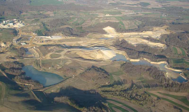
3 28 Big River Magazine / July-August 2013 Trempealeau County, Wis., has many frac-sand mines, the largest of which is probably this one, operated by Preferred Sands, LLC, near Blair, Wis. The Wisconsin Center for Investigative Journalism reports that the site covers 400 acres and 150 acres will be mined. According to a company spokesman, the mine is owned by Michael O Neill and has 88 employees. In 2012 it shipped 481,747 tons of sand by rail (none by truck or barge), and has a storage capacity of 15,000 tons in six silos. It appears that all or most of some bluffs have already been mined away. These photos are all of the same site from different angles. Note the processing and storage operations, as well as the railroad switching yard in the bottom right photo.
4 July-August 2013 / Big River Magazine 29


5 30 Big River Magazine / July-August 2013 The Biesanz Mine is in the Winona, Minn., city limits on a ridge in the southwest end of town. For decades they mined dolomite stone for construction, but recently they have been setting aside the dolomite to get at the frac sand underneath. Some nearby neighbors have complained about blasting at the mine.

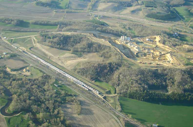
6 Fairmont Minerals owns this underground mine just downstream from Maiden Rock, Wis., on Lake Pepin. The company employs 60 people at the mine, which extends 349 acres under the bluff. This mine has been in operation since The company shipped about a million tons of sand from the mine in 2012, mostly by rail, according to a company spokesperson. Note the sand processing and storage facilities in the top of the photo and the Great River Road and the Burlington Northern Santa Fe tracks at the bottom of the photo. July-August 2013 / Big River Magazine 31
LAS VARAS RANCH CA COASTAL TRAIL PROPOSED ALIGNMENT
 LAS VARAS RANCH CA COASTAL TRAIL PROPOSED ALIGNMENT Santa Barbara Trails Council * Prepared by Ray Ford February 1,2012 The following notes accompany the Santa Barbara Trails Council map for the Las Varas
NARCOA operates on up to 200 railroads every year all over North America, including short lines, regional railroads, and Class 1 railroads.
 Riding the Rails NARCOA, or the North American Railcar Operators Association, is a nonprofit organization dedicated to the preservation and safe, legal operation of railroad equipment historically used
I INTRODUCTION AND BACKGROUND
 I INTRODUCTION AND BACKGROUND INTRODUCTION AND BACKGROUND - I I INTRODUCTION AND BACKGROUND a. project setting Looking south to the project site The Davenport Cement Plant (also referred to as the Cemex
Guide to the L. F. Manis Photographs
 This finding aid was produced using ArchivesSpace on February 29, 2016. English 2016 The Regents of the University of Nevada. All rights reserved. University of Nevada, Las Vegas. University Libraries.
Finding Locations on a Map
 Name Date Class Finding Locations on a Map Identify each place described below. Use the map of the Mississippi in your textbook to find the answers. 1. This state is bordered on the north by Missouri and
Guide to the L. F. Manis Photographs
 This finding aid was created by Lindsay Oden on February 27, 2018. Persistent URL for this finding aid: http://n2t.net/ark:/62930/f1vk60 2018 The Regents of the University of Nevada. All rights reserved.
Wright City Business Park
 Wright City Business Park 51.69 Acres SITE Wright City Business Park is a 51.69 acre site ideal for large distribution or manufacturing uses. Located approximately ¼ mile west of I-70 exit 199, Wright
COLL 85 Raymond Specht Railroad Collection,
 COLL 85 Raymond Specht Railroad Collection, 1868-1993 BOX FOLDER CONTENTS 1 1 Ahnapee & Western 1906-1966 & N.D. 2 A.H. Stange Co. N.D. 3 American Engineering Company s 49 Reasons Why New Railways Fail
Panama Canal Stakeholder Working Group Meeting
 Panama Canal Stakeholder Working Group Meeting POHA, Bayport Container Terminal, Houston, Texas August 27, 2012 TOTAL ECONOMIC IMPACT 9,749 Texas jobs are in some way related to the Port Of the 9,749
ON TIME AND ON BUDGET: PROCESSING PLANT OVER 90% COMPLETE AND FIRST PRODUCTION SET FOR MARCH
 MT MORGANS GOLD PROJECT UPDATE 11 JANUARY 2018 ON TIME AND ON BUDGET: PROCESSING PLANT OVER 90% COMPLETE AND FIRST PRODUCTION SET FOR MARCH Underground mining 873m ahead of schedule with ore intersected
6-Ride like a Minnesotan Alphabet Roads - 295/332mi
 6-Ride like a Minnesotan Alphabet Roads - 295/332mi The area north of State Highway 33 is where most Minnesotans regularly ride even though it means that rides start about 90 miles from the Twin Cities.
PLATTE COUNTY PLANNING AND ZONING JANUARY 15, 2014
 PLATTE COUNTY PLANNING AND ZONING JANUARY 15, 2014 Acting Chairman Bob Brockman called the Platte County Planning and Zoning Commission meeting to order at 7:00 P.M. The only Commission member present
Big Sable Point Lighthouse Les & Arlene Meverden Ludington, MI 49431
 Les & Arlene Meverden Ludington, MI 49431 My Interview with Les and Arlene Meverden and their daughter Janet was held on June 5, 2004. I first learned about the Meverden family through an article published
AVAILABLE SPACE KANAWHA MANUFACTURING BUFFALO PLANT
 AVAILABLE SPACE KANAWHA MANUFACTURING BUFFALO PLANT LOCATION Building Address - Route 62 Located in City Limits - No County - Putnam Located in Business/Industrial Park - No Can the Building be Multi-Tenant
West Virginia Office of Miners Health, Safety & Training. January 4, Report of Investigation Underground Coal Mine Fatality (Machinery Accident)
") West Virginia Office of Miners Health, Safety & Training January 4, 2016 Report of Investigation Underground Coal Mine Fatality (Machinery Accident) Greenbrier Minerals, LLC Lower War Eagle Mine Permit
West Virginia Office of Miners Health, Safety & Training January 4, 2016 Report of Investigation Underground Coal Mine Fatality (Machinery Accident) Greenbrier Minerals, LLC Lower War Eagle Mine Permit
2015 Brain Wrinkles. SS8G1b
 SS8G1b Georgia is a geographically diverse state that is divided into five regions. The first three regions (Appalachian Plateau, Valley and Ridge, and Blue Ridge) are in the mountains and foothills of
Immersion. Program. at Luther. Orientation Adventure-style
 Immersion at Luther Program Orientation Adventure-style Begin your college experience with new relationships, renewed confidence, and adventure! Immerse. Engage in new friendships Immersion trips are weeklong
HOME LAYOUTS LAYOUT TOUR DESCRIPTIONS UPDATED 5/26/17. MIKE BENNETTE O Scale. JIM BARTA HO Scale. Nine Mile Falls, WA.
 LAYOUT TOUR DESCRIPTIONS UPDATED 5/26/17 HOME LAYOUTS JIM BARTA MIKE BENNETTE O Scale Nine Mile Falls, WA Deer Park, WA This large home scale layout has only been under construction only 18 months, but
Topographic Maps. Background Sheet
 Topographic Maps History: Background heet The Articles of Confederation (1777) was ratified when western lands were yielded to the Federal Government. This yielding of land gave the Federal Government
National No. 2 (Bob Ciminel 2012)
") National No. 2 (Bob Ciminel 2012) Coming timetable east out of Muse Junction, we begin ascending the 1% grade to National Tunnel at MP 27. After passing through the tunnel s 823-foot bore we begin our
National No. 2 (Bob Ciminel 2012) Coming timetable east out of Muse Junction, we begin ascending the 1% grade to National Tunnel at MP 27. After passing through the tunnel s 823-foot bore we begin our
Sands Motel 112 McArthur St, Grants, New Mexico 87020
 Sands Motel 112 McArthur St, Grants, New Mexico 87020 6565 Americas Pkwy NE Suite 200, Albuquerque, NM 87110 verify the subject offering as suitable for the intended use. Neither exp Realty LLC, it s agents
SS8G1 The student will describe Georgia with regard to physical features and location.
 SS8G1ab Standards SS8G1 The student will describe Georgia with regard to physical features and location. a. Locate Georgia in relation to the region, nation, continent, and hemispheres. b. Describe the
Abandoned Mine Sites Policy
 SUBJECT: Abandoned Mine Sites Policy Policy Number: MRE 006 2004 C. R. File Number: 565 00 0002 Effective Date: September 1, 2004 To Be Reviewed: September 1, 2008 Approval: Original signed by W. David
A Brief Overview of the Rio Grande Compact 04/26/06
 A Brief Overview of the Rio Grande Compact 04/26/06 The New Mexico Interstate Stream Commission Investigate, Protect, Conserve, and Develop the State s Waters and Stream Systems Negotiate and Administer
Table 14: Transportation Page 1
 Table 14: Transportation Page 1 Major 2 and 4 Lane Highways Linking the Area Metro Area Miles Interstate 40 to Las Angeles, California 318 US Highway 93 to Las Vegas, Nevada 103 US Highway 95 to Yuma,
447 Route 28 West Yarmouth MA 02673
 CAREY COMMERCIAL, INC. BUSINESS & INVESTMENT PROPERTY 146 MAIN STREET HYANNIS, MA 02601 for sale 2 ACRES OF COMMERCIAL LAND 447 Route 28 West Yarmouth MA 02673 Contact: Chuck Carey 508-790-8900 Ext. 11
APPENDIX B. IOWA MRT MAPS
 APPENDIX B. IOWA MRT MAPS This appendix contains map information as referred to in the body of Iowa s Mississippi River Trail Plan. Many maps were generated during the planning process; maps were created
Oil By-Pass Filter Installation. By: Woodnthings8
 Oil By-Pass Filter Installation By: Woodnthings8 Keeping clean oil in a 7.3L Powerstroke is probably the most important thing you can do to increase longevity and decrease wear. The oil filter installed
A GUIDE TO THE ROSE BARGE LINE COLLECTION P-30. Copyright The St. Louis Mercantile Library Association. St. Louis, Missouri
 A GUIDE TO THE ROSE BARGE LINE COLLECTION P-30 Copyright 2011 The St. Louis Mercantile Library Association St. Louis, Missouri Project Staff Director: John Neal Hoover Curator, Herman T. Pott National
EAA EAGLE FLIGHTS. Come on, lets go flying!
 EAA EAGLE FLIGHTS Introductory flight experiences for adults An Eagle Flight is your opportunity to experience all that aviation has to offer. Come on, lets go flying! Sponsored by Las Vegas valley EAA
TERRESTRIAL S Night Skies & Natural Sounds
 TERRESTRIAL S Night Skies & Natural Sounds INTRODUCTION OBJECTIVES (Background and acoustical monitoring information was taken from the National Park Service website http:// www.nature.nps.gov/sound/assets/docs/interphandbook.pdf)
QUARTERLY ACTIVITIES REPORT 31 JANUARY 2019
 NEW HOPE CORPORATION LIMITED ABN: 38 010 653 844 QUARTERLY ACTIVITIES REPORT 31 JANUARY 2019 18 February 2019 Quarter Ended 6 Months Ended Jan-19 Jan-18 Change Jan-19 Jan-18 Change ( 000t) ( 000t) (%)
Dubuque County Zoning Board of Adjustment Minutes of May 1, 2018 Chairperson Ron Koppes called the meeting to order at 7 p.m.
 Dubuque County Zoning Board of Adjustment Minutes of May 1, 2018 Chairperson Ron Koppes called the meeting to order at 7 p.m. A. ROLL CALL: Members Present: Ron Koppes, Darlene Burds, Thomas Griep, Pat
UNITED STATES DEPARTMENT OF LABOR MINE SAFETY AND HEALTH ADMINISTRATION. Southeastern District Metal and Nonmetal Mine Safety and Health
 UNITED STATES DEPARTMENT OF LABOR MINE SAFETY AND HEALTH ADMINISTRATION Southeastern District Metal and Nonmetal Mine Safety and Health Accident Investigation Report Surface Nonmetal Mine Fatal Falling/Sliding
POSTCARDS AND OLD PHOTOS OF THE PARK ERA, The Midway
 POSTCARDS AND OLD PHOTOS OF THE PARK ERA, 1885-1911 The majority of these photographs appear to have been taken during the latter period of the park, circa 1905 to 1911. The Midway A lovely afternoon at
The Black Diamond. Official Newsletter of the Lehigh Valley Railroad Historical Society May/June, 2007
 The Black Diamond Official Newsletter of the Lehigh Valley Railroad Historical Society May/June, 2007 Message From The Editor Welcome to the May/Jun, 2007 edition of the Black Diamond. Please send any
Retail/Office Free-Standing Bldg For Sale or Lease 439 W Baseline St San Bernardino CA 92410
 For Sale or Lease Free-Standing Bldg Tenant: VACANT GLA: 10,000 SF Lot Size: 33,000 SF Price Per SF: $79.50 Asking Price: $975,000 NEW PRICE: $899,000 Highlights: Baseline is a Main Artery in The City
Altoona Board of Adjustment Hearing November 14, :30 PM Altoona City Hall
 Altoona Board of Adjustment Hearing November 14, 2017 6:30 PM Altoona City Hall Members Present: Hall, Rullman, Simon, Morris Members Absent: Downs Staff: John Shaw, Chad Quick, Sydney McCabe, Greg Stallman
Dubuque County Zoning Board of Adjustment Minutes of March 6, 2018 Chairperson Ron Koppes called the meeting to order at 7 p.m.
 Dubuque County Zoning Board of Adjustment Minutes of March 6, 2018 Chairperson Ron Koppes called the meeting to order at 7 p.m. A. ROLL CALL: Members Present: Ron Koppes, Darlene Burds, Thomas Griep &
Provincial Review 2016: Limpopo
 Provincial Review 2016: Limpopo Limpopo s growth since 2003 has been dominated by the mining sector, especially platinum, and by national construction projects. As a result, the provincial economy grew
2015 Brain Wrinkles. SS8G1b
 SS8G1b Standards SS8G1 The student will describe Georgia with regard to physical features and location. b. Describe the five geographic regions of Georgia; include the Blue Ridge Mountains, Valley and
FAIRMONT, WEST VIRGINIA
 AVAILABLE SPACE PHILLIPS SERVICES WAREHOUSE FAIRMONT, WEST VIRGINIA LOCATION Building Address - 24 Philips Lane Fairmont, WV 26554 Located in City Limits - Yes Zoning - County - Marion Located in Business/Industrial
Chicago Great Western RR
 Chicago Great Western Railroad CHIGAGO GREAT WESTERN RAILROAD................................................ Inc. in IL, August 19, 1909 756.112 mi. First main track 59.124 mi. Second and other main tracks
EL LIMON MINE: EMPLOYEES & CONTRACTORS 133
 132 EL LIMON MINE: EMPLOYEES & CONTRACTORS 133 B2Gold Employees Direct 552 Nicaraguans 548 Expats 4 Unionized 494 Men 499 Women 53 Contractors Employees 570 Men 529 Women 41 EL LIMON MINE: NICARAGUA OPEN
Ohio Freight Conference Great Lakes Commercial Navigation
 Ohio Freight Conference Great Lakes Commercial Navigation Roger E. Haberly Regional Economist Buffalo New York 13 September 2013 US Army Corps of Engineers Presentation Overview 1. GL Physical System Description
Gifts of the Glaciers
 Gifts of the Glaciers Gifts of the Glaciers Moving ice of glacier was responsible for water, landforms, and soil characteristics and patterns of today Sculpturing of bedrock materials Glacial Landforms
Bankhead Lake TWO PARCELS AND 1 LOT FOR SALE
 OVERVIEW NORTH PARCEL ACRES: 46 WATERFRONT: 1,227 Front Feet PRICE: $350,000 PER ACRE: $7574 PER FRONT FT. $285 SOUTH PARCEL ACRES: 22 WATERFRONT: 1,381 Front Feet PRICE: $295,000 PER ACRE: $13,170 PER
Mason Street Bike/Pedestrian Trail Project
 Construction of the much-anticipated Mason Trail is underway! Mountain Constructors was awarded the contract in September but had to go through a 2- month process to obtain construction clearance permits
Construction Access Routes
 Sociedad Minera Cerro Verde S.A.A. Primary Sulfide Project Feasibility Study Project No. 12 7606 00 Construction Access Routes Document No. C-EV-10-003 Rev. B 1 March 2004 Prepared by: Fluor Engineering
BA Collaborators. Driftless Area Initiative The Prairie Enthusiasts Trout Unlimited TNC TCF Natural Resources Foundation of Wisconsin
 BA Collaborators Driftless Area Initiative The Prairie Enthusiasts Trout Unlimited TNC TCF Natural Resources Foundation of Wisconsin The mission of the of the Blufflands Alliance is to actively conserve
JOURNAL OF THE CSXT HISTORICAL SOCIETY
 JOURNAL OF THE CSXT HISTORICAL SOCIETY Volume 5 Number 1 CSXTHS 2016 CONVENTION CSXTHS is not affiliated with CSX Transportation and is a nonprofit corporation chartered under the laws of Kentucky. CSX
Limestone Road Industrial Area Brandon Manitoba ~141 Acres Rail Accessible, Ready for Development
 Limestone Road Industrial Area Brandon Manitoba ~141 Acres Rail Accessible, Ready for Development Dan Fontaine Business Development Specialist 204.729.2133 or 1.866.729.2132 D.Fontaine@brandon.ca EconomicDevelopmentBrandon.com
OKLAHOMA HISTORY OKLAHOMA S GEOGRAPHY
 OKLAHOMA HISTORY OKLAHOMA S GEOGRAPHY BOARD QUESTIONS 1) HOW BIG IS OKLAHOMA? 2) HOW MANY COUNTIES ARE IN OKLAHOMA? 3) HOW FAR IS IT FROM OKC TO LAS ANGLES, CALIFORNIA? 4) HOW MANY STATE BORDER OKLAHOMA?
China Interests in Sub-Saharan Africa. Economic and Political Interests between the Growing Superpower and Continent
 China Interests in Sub-Saharan Africa Economic and Political Interests between the Growing Superpower and Continent China s Current Situation Rapidly growing economy o GDP growth rate ~10% in last 3 decades
No. 23. Milling Around. Motor Mill Historic Site Newsletter. Larry Stone. Clayton County Conservation Board Osborne Rd.
 Motor Mill Foundation Summer 2016 No. 23 Milling Around Motor Mill Historic Site Newsletter Larry Stone Clayton County Conservation Board 29862 Osborne Rd Elkader, IA 52043 The completion of the new bridge
Monthly. The Railroad Museum at Ardenwood is located at Ardenwood Historic Farm, in Fremont, California. Barbara Culp
 Monthly February, 2014 Edition. Hotbox is a monthly publication of The Railroad Museum at Ardenwood, designed to update members and the general public about activities, work events, and volunteer opportunities
Sector Upper Mississippi River All Threats All Hazards Always Ready
 Sector Upper Mississippi River All Threats All Hazards Always Ready Commander Katherine Weathers Chief, Planning & Force Readiness 5 Inland River Tenders (WLR) 3 Marine Safety Detachments (MSD) 4 Shore
W. SAM HOUSTON PARKWAY N. HOUSTON, TEXAS
 4851 W. SAM HOUSTON PARKWAY N. HOUSTON, TEXAS SCHEME 1 BUILD TO SUIT YOUR NEEDS The property will offer a 144,000 to 188,000 square foot Class A mid-rise office building located in west Houston near the
Auto Repair Business, Real Estate & Equipment
 For Sale OWNER WILL CARRY FINANCING FOR QUALIFIED BUYER!!! Auto Repair Business, Real Estate & Equipment Features: Sales Price: $650,000.00 Building Size: 7,675+/- SF Lot Size: 15,000+/- SF Highlights:
SUNPORT SOUTH BUSINESS PARK
 SUNPORT SOUTH BUSINESS PARK IS A NEW 330 ACRE DEVELOPMENT WITH RAIL, INTERSTATE AND AIRPORT ACCESS IN ALBUQUERQUE, NEW MEXICO. WHATEVER YOUR INDUSTRIAL NEED IS, SUNPORT SOUTH DELIVERS. COLLIERS INTERNATIONAL
CASS SCENIC RAILROAD. Cass, West Virginia. Written by Dan Whetzel Photography by Lance C. Bell
 CASS SCENIC RAILROAD Cass, West Virginia Written by Dan Whetzel Photography by Lance C. Bell m o u n t a i n d i s c o v e r i e s 49 Facing page: Cass Scenic Railroad s Heisler #6 departs from the depot
WISCONSIN CUSTOM RATE GUIDE 2017 GENERAL: DATA: DISTRICT AND REGIONAL DATA:
 Wisconsin Department of Agriculture, Trade, and Consumer Protection 2811 Agriculture Dr., Madison, WI 53718 1-800-789-9277 www.nass.usda.gov/wi WISCONSIN CUSTOM RATE GUIDE 2017 MARCH 2018 GENERAL: The
Premier Downtown San Jose Office Space
 Premier Downtown San Jose Office Space For Lease ±603 SF - ±1,528 SF For Lease ±603 SF - ±1,528 SF Fantastic Central Location in San Jose s Reborn Downtown 8-story office building Abundant natural light
Black Hill Regional Park, Little Seneca Lake
 Black Hill Regional Park, ittle Seneca ake ittle Seneca ake, in Black Hill Regional Park, is a reservoir created after a previous drought struck the Washington area. The park is under Maryland-National
MEMORANDUM. DATE: May 16, TO: Monica Harrower, PennDOT District 6-0. Mary Alfson Tinsman CHRS, Inc. 451 North Cannon Avenue, Suite 100B
 MEMORANDUM DATE: May 16, 2011 TO: Monica Harrower, PennDOT District 6-0 FROM: RE: Mary Alfson Tinsman CHRS, Inc. 451 North Cannon Avenue, Suite 100B Lansdale, PA 19446 French Creek Parkway Project Phoenixville
LOCALITY MAP. For leasing info: BROKERS WELCOME. custom leasing solutions in a native environment. Comments:
 LOCALITY MAP Comments: Located on the southern edge of the greater Phoenix area, between the cities of Maricopa and Casa Grande, in Pinal County, Arizona Close proximity to Interstates 8 & 10, Highways
NPS Form a OMB No (8-86) Expires
 Expires") Section: F Page 247 Railroads in Minnesota, 1862-1956 Figures Railroad Roadway Edge of Right of Way Edge of Right of Way Railroad Bed Figure 1. Railroad Corridor, Young America vicinity, ca. 1915 Section:
Section: F Page 247 Railroads in Minnesota, 1862-1956 Figures Railroad Roadway Edge of Right of Way Edge of Right of Way Railroad Bed Figure 1. Railroad Corridor, Young America vicinity, ca. 1915 Section:
Exam Review. Part 3- Deserts, Glaciers, and maps
 Exam Review Part 3- Deserts, Glaciers, and maps What causes a desert? Lots of sand Vegetation holds the arms Star Dunes- Star dunes form only in places where wind blows from varied directions over the
CITY OF HARBOR SPRINGS Zoning Board of Appeals June 12, 2013
 CITY OF HARBOR SPRINGS Zoning Board of Appeals Chairperson Henry Pfeifer called the meeting of the Harbor Springs Zoning Board of Appeals () to order at 5:30 p.m., at City Hall Council Chambers, 160 Zoll
HARBOR INFRASTRUCTURE INVENTORIES Duluth-Superior Harbor, Minnesota/Wisconsin
 HARBOR INFRASTRUCTURE INVENTORIES Duluth-Superior Harbor, Minnesota/Wisconsin Harbor Location: Duluth-Superior Harbor is located at the westernmost tip of Lake Superior. Authority: River & Harbor Act of
Lewiston Silo Subject Area: Social Studies Grades 6-8
 Lewiston Silo Subject Area: Social Studies Grades 6-8 New York State Social Studies Learning Standards Standard 1 History of the United States and New York Students will: Use a variety of intellectual
History of the Environment Movement in the United States. {Environmental PBL
 History of the Environment Movement in the United States {Environmental PBL The First People in North America 25,000 years ago Many Native Americans are nomadic cultures Viewed themselves as one with nature
Creating Short Sea Opportunities - The Terminal s Role
 American Association of Port Authorities Creating Short Sea Opportunities - The Terminal s Role Growth Opportunities for General Cargo and Shallow Draft Ports Memphis, TN November 14, 2006 Maurice S. Owen,
HO, HO, HO, SAID OUR OPEN HOUSE VISITOR
 2013 HO, HO, HO, SAID OUR OPEN HOUSE VISITOR Feb 2&3, Great Train Expo, Timonium, MD Feb 23&24, Greenburg Train Show, VA Beach For more information on these shows - Google or go to http:// www.trainweb.org/
Master Commercial Developer Industry Forum
 Master Commercial Developer Industry Forum Agenda 9:00 am Welcome Phil Washington, Metro CEO Metro Board Director Solis 9:15 am Introductions and Overview of the Event Jenna Hornstock, Executive Officer,
HARBOR INFRASTRUCTURE INVENTORIES Buffalo Harbor, New York
 HARBOR INFRASTRUCTURE INVENTORIES Buffalo Harbor, New York Harbor Location: Buffalo Harbor is located on the Eastern shore of Lake Erie in the City of Buffalo, NY. Authority: River & Harbor Acts of 1826,
Australian Site Tour Ravensthorpe Nickel Operation. Isak Buitendag General Manager
 Australian Site Tour Ravensthorpe Nickel Operation Isak Buitendag General Manager 29 October 2008 Important notices Reliance on third party information The views expressed here contain information that
Pizza Hut Portfolio % CAP 5 Iowa Locations - Must be purchased as a portfolio
 Pizza Hut Portfolio - 8.25% CAP 5 Iowa Locations - Must be purchased as a portfolio Investment Summary CAP Rate: 8.25% Lease Options: 4 Five Year Options Increases: 1% Annual Lease Type: Absolute NNN No
CHAPTER VII: ASSETS, AMENITIES AND UNIQUE OFFERINGS
 CHAPTER VII Other Assets, Amenities, and Unique Offerings in the Tri- City Area The Tri- City area of Cumberland, Benham, and Lynch has numerous unique offerings that, in themselves, are major draws to
PLEASANT VALLEY, WEST VIRGINIA
 AVAILABLE SPACE BPS BUILDINGS PLEASANT VALLEY, WEST VIRGINIA LOCATION Building Address - 2103 Pleasant Valley Road Pleasant Valley, WV 26554 Located in City Limits -Yes, but no B&O Tax Zoning - Mixed use
Riverine Sand Mining/Scofield Island Restoration (BA-40)
") Riverine Sand Mining/Scofield Island Restoration (BA-40) Conference on Ecological and Ecosystem Restoration Kenneth Bahlinger, CPRA Project Manager July 31, 2014 committed to our coast committed to our
Riverine Sand Mining/Scofield Island Restoration (BA-40) Conference on Ecological and Ecosystem Restoration Kenneth Bahlinger, CPRA Project Manager July 31, 2014 committed to our coast committed to our
MESA COUNTY DEPARTMENT OF PUBLIC WORKS Administration - Building - Engineering Road and Bridge Traffic - Planning - Solid Waste Management
 MESA COUNTY DEPARTMENT OF PUBLIC WORKS Administration - Building - Engineering Road and Bridge Traffic - Planning - Solid Waste Management 200 S. Spruce St. P.O. Box 20,000 Grand Junction, Colorado 81502-5022
DETROIT, TOLEDO, AND IRONTON RAILROAD PHOTOGRAPHS SUBSERIES, Accession 548
 Finding Aid for DETROIT, TOLEDO, AND IRONTON RAILROAD PHOTOGRAPHS SUBSERIES, 1922-1923 Finding Aid Published: June 2011 20900 Oakwood Boulevard Dearborn, MI 48124-5029 USA research.center@thehenryford.org
For personal use only
 Iron Ore Holdings Ltd Investor Presentation July 2014 IOH - Company Status 2 Corporate Overview Background ASX listed in 2005 1.6 billion tonnes JORC Mineral Resources Iron Valley Project production in
WORLD HERITAGE ( ) Focus Questions
 Focus Questions") Text 2014 In The News FEATURE STORY ACTIVITIES 11 March 2014 Page 1 / 5 WORLD HERITAGE (6.32 10.28) Concerns have been raised about dredging plans for an area close to the Great Barrier Reef, one of Australia
Text 2014 In The News FEATURE STORY ACTIVITIES 11 March 2014 Page 1 / 5 WORLD HERITAGE (6.32 10.28) Concerns have been raised about dredging plans for an area close to the Great Barrier Reef, one of Australia
STRATEGIC ALLIANCES BETWEEN PORTMIAMI AND ITS CRUISE AND CARGO PARTNERS
 STRATEGIC ALLIANCES BETWEEN PORTMIAMI AND ITS CRUISE AND CARGO PARTNERS Richard de Villiers Assistant to the Deputy Port Director AAPA Conference, February 5-7, 2013 Merida, Mexico MIAMI-DADE COUNTY GOVERNMENT
Antinoupolis. Ongoing Destruction. Pre-2006 crops. Modern cemetery covering. ancient cemetery. Antinoupolis, ancient city. North cemetery (ancient).
.") Antinoupolis Ongoing Destruction Ongoing Destruction North cemetery (ancient). Pre-2006 crops Modern cemetery covering ancient cemetery. Antinoupolis, ancient city. Modern village of el Sheikh Abada Nile
Antinoupolis Ongoing Destruction Ongoing Destruction North cemetery (ancient). Pre-2006 crops Modern cemetery covering ancient cemetery. Antinoupolis, ancient city. Modern village of el Sheikh Abada Nile
SAN MIGUEL CREEK RANCH. q Trinidad, Las Animas County, Colorado q
 SAN MIGUEL CREEK RANCH q Trinidad, Las Animas County, Colorado q 2 s San Miguel Creek Ranch is a scenic well-balanced cattle and trophy hunting ranch that showcases the very best of Southern Colorado.
Yucca Mountain Nuclear Fuel Locations and Associated Rail Facilities. Diablo Canyon Power Plant, California
 Yucca Mountain Nuclear Fuel Locations and Associated Rail Facilities Diablo Canyon Power Plant, California Yucca Mountain: Nuclear Fuel Locations and Associated Rail Facilities October 1, 2010 Final Report
The Kitanemuk, members of the Shoshonean Linguistic Group lived in the area between Fairmont and Antelope Buttes: one of the largest and most
 The Kitanemuk, members of the Shoshonean Linguistic Group lived in the area between Fairmont and Antelope Buttes: one of the largest and most significant archaeological sites in the Antelope Valley Source:
Commercial Explosives Licensed Contractors
 Commercial Explosives d Contractors Fire Marshasl Division Des Moines, 50319 ADM-Clinton CB-53 1251 Beaver Channel Parkway Clinton 52732 (563) 244-5209 ADM-Keokuk CB-22 2620 Henkel Ave Keokuk 52632 (319)
Photography Guide U.P. of Michigan
 Photography Guide U.P. of Michigan Porcupine Mountains Pictured Rocks National Seashore & Tahquamenon Falls By Bill Welch The U.P. of Michigan Michigan s Upper Peninsula (the U.P.) is a forest covered
Devils Lake Planning Commission
 Devils Lake Planning Commission 3-26-15 Members present: Greg Semenko, Terry Thompson, Rodger Haugen, Tim Greene, Mike Grafsgaard, Dick Johnson, Kevin Davidson, Gary Martinson, Ray Sletteland, Larry Liere
ERA overview. Dan Janney General Manager, Operations
 ERA overview Dan Janney General Manager, Operations 1 2 Welcome to Ranger mine Acknowledge Traditional Owners The mining operations of Energy Resources of Australia Ltd (ERA) are located on Aboriginal
Letter Assessment. (date) Dear, In 1864, Then in 1866, In 1867, As it happened in 1868, Then in 1877, The bust came in.
 Dear, In 1864, Then in 1866, In 1867, As it happened in 1868, Then in 1877, The bust came in.") Letter Assessment (date) Dear, In 1864, Then in 1866, In 1867, As it happened in 1868, Then in 1877, The bust came in. Your friend, The Birth of a City and Railroad in the Rocky Mountains Modified for
Letter Assessment (date) Dear, In 1864, Then in 1866, In 1867, As it happened in 1868, Then in 1877, The bust came in. Your friend, The Birth of a City and Railroad in the Rocky Mountains Modified for
Mining & Railways in Weardale. by Barry Kindleysides
 Mining & Railways in Weardale by Barry Kindleysides In 1154 King Stephen granted all the mineral rights in Weardale to his nephew Hugh Bishop of Durham. From then on a succession of Bishops owned these
Katrina Recovery: Helping Hands. Biloxi, Mississippi November 2005
 Katrina Recovery: Helping Hands Biloxi, Mississippi November 2005 The Call October e-mail from the National Diaconate Office: We ve been saying wait, but NOW is the time! Get yourself here, bring sleeping
FOR SALE >> VACANT LAND. Albuquerque, PRESENTED BY: COLLIERS INTERNATIONAL TOM FRANCHINI, CCIM BILL ROBERTSON
 FOR SALE >> WEST FOR SALE >> MESA Albuquerque, West Mesa NM Vacant Land PRESENTED BY: BILL ROBERTSON LIC. #8433 SENIOR VICE PRESIDENT PRINCIPAL DIR +1 505 880 7050 CELL +1 505 263 6644 BILL.ROBERTSON@COLLIERS.COM
Division 5, NCR, NMRA. February 2018
 Capital Division Superintendent Andy Keeney http://civ5ncr-nmra.org/ Division 5, NCR, NMRA Clerk and Editor: Mark Cowles All Photos are by the editor unless otherwise credited. February 2018 Our next get
APPENDIX E LYONS PARK ESTATES DETAILED COMMUNITY ASSESSMENT RESULTS
 # Houses: 65 APPENDIX E LYONS PARK ESTATES DETAILED COMMUNITY ASSESSMENT RESULTS Overall Risk Assessment: High Description: Lyons Park Estates is located on the foothills south of the town of Lyons on