History Quiz. A presentation by Neil Martin to the KEU3A Local History Group on 18 th January 2017 KINGSBRIDGE ESTUARY LOCAL HISTORY
|
|
|
- Asher Greer
- 5 years ago
- Views:
Transcription


1 History Quiz A presentation by Neil Martin to the KEU3A Local History Group on 18 th January 2017 KINGSBRIDGE ESTUARY LOCAL HISTORY After the quiz, we will take a few minutes to discuss if any of these topics might be of interest for future Society meetings? 1


2 Question 1 Where would you find a Celtic hilltop fort close to Kingsbridge? Blackdown Rings (or Loddiswell Rings) was built around 400BC by the Celts The reason for the emergence of hill forts in Britain, and their purpose, has been a subject of debate 2
3 The Celts or Keltoi as branded by the Ancient Greeks in about 500 BC built chains of hilltop forts for defence and settlement in Devon and vestiges of these remain around Kingsbridge and Salcombe Keltoi were banded together on the basis of their language The Blackdown Rings are the earthworks of an Iron Age hill fort near the hamlet of Hazelwood in Devon, England. The fort is situated on a hilltop approximately 185 metres above sea level, in a commanding position above the River Avon. For information, there are over 100 recorded Iron Age or older sites within 30 km of the Blackdown Hills: 5.2km E 92 Halwell Camp South West* Hillfort (SX ) 5.4km E 89 Ritson Barrows Barrow Cemetery (SX ) 5.7km NW 298 Ugborough Parish Church Prehistoric Earthwork* Ancient Village or Settlement (SX ) 6.5km E 82 Halwell Camp North East* Hillfort (SX784532) 7.3km SW 238 Bigbury Tumuli Barrow Cemetery (SX667470) 8.2km NW 297 Cantrell* Multiple Stone Rows / Avenue (SX657572) 8.2km SW 244 Marwell St. Mary's Well* Holy Well or Sacred Spring (SX653472) 8.3km W 274 Holy Well, Ermington* Holy Well or Sacred Spring (SX ) 8.6km NW 308 Ugborough Beacon Cairns Cairn (SX667588) 8.6km NW 301 Cuckoo Ball Chambered Tomb* Chambered Tomb (SX659581) 8.9km NW 304 Butterdon Hill Long Cairn* Long Barrow (SX ) 9.3km NW 302 Butterdon Hill Cairns* Cairn (SX655587) 9.4km NW 303 Butterdon Stone Circle* Stone Circle (SX ) 9.4km NW 306 Butterdon East Stone Row / Alignment (SX ) 9.6km NW 312 Scad Brook Ancient Village or Settlement (SX ) 9.6km NW 306 Butterdon Hill Cist* Cist (SX ) 9.7km NW 301 Weatherdon Hill Ring Cairn (SX ) 9.7km NW 305 Butterdon Hill Barrow* Round Barrow(s) (SX657594) 9.7km W 263 Holbury Camp (Devon) Hillfort (SX ) 9.8km N 343 Brent Hill* Hillfort (SX704617) 10.0km NW 307 Spurrells Cross Cairn Circle* Stone Circle (SX658598) 10.0km NW 306 Butterdon Hill Row* Stone Row / Alignment (SX ) 10.0km NW 308 Spurrell's Cross* Ancient Cross (SX659600) 10.1km NW 313 Lower Glasscombe* Cist (SX ) 10.1km NW 308 Spurrells Cross Row* Multiple Stone Rows / Avenue (SX658600) 10.3km NW 301 Butter Brook* Standing Stone (Menhir) (SX ) 10.4km NW 304 Harford S* Multiple Stone Rows / Avenue (SX651598) 10.4km NW 305 Butterbrook* Stone Row / Alignment (SX652599) 10.5km NW 305 Harford Moor N* Stone Row / Alignment (SX651599) 10.5km NW 309 Glasscombe Ball SW* Stone Row / Alignment (SX657604) 10.5km NW 320 Treeland Brake* Stone Row / Alignment (SX673614) 10.5km NW 316 Corringdon Ball South* Multiple Stone Rows / Avenue (SX ) 10.6km NW 318 Ball Gate* Ring Cairn (SX ) 10.6km NW 312 Glasscombe Ball NE* Multiple Stone Rows / Avenue (SX661608) 10.6km NW 312 Glasscombe Corner* Stone Row / Alignment (SX661608) 10.6km NW 316 Corringdon Ball Central* Multiple Stone Rows / Avenue (SX ) 10.6km NW 301 Harford settlement* Ancient Village or Settlement (SX644594) 10.6km NW 308 Hobajons Cross* Standing Stone (Menhir) (SX655604) 10.6km NW 316 Corringdon Ball SE* Stone Circle (SX ) 10.6km NW 319 Corringdon Ball Tomb* Chambered Tomb (SX670614) 10.6km NW 316 Corringdon Ball* Multiple Stone Rows / Avenue (SX ) 10.7km NW 316 Corringdon Ball N.* Stone Row / Alignment (SX666612) 10.7km NW 302 Harford Moor Stone Circle (SX645596) 10.7km NW 316 Corringdon Ball NW* Stone Circle (SX ) 10.7km NW 317 Brent Fore Hill* Multiple Stone Rows / Avenue (SX667613) 10.8km NW 315 Upper Glazebrook* Ancient Village or Settlement (SX ) 10.9km SW 233 Burgh Island fort Promontory Fort / Cliff Castle (SX647439) 10.9km SW 233 Burgh Island fort Promontory Fort / Cliff Castle (SX647439) 10.9km NW 309 The Longstone (Piles Hill)* Standing Stone (Menhir) (SX654607) 11.1km NW 304 Lower Piles* Stone Circle (SX645602) 11.1km NW 309 Piles Hill Cairns* Cairn (SX653609) 11.1km NW 310 Piles Hill NE* Stone Row / Alignment (SX654610) 11.3km NW 322 Hickley Ridge Central* Cist (SX ) 11.3km NW 323 Hickley Ridge East* Cist (SX ) 11.4km NW 318 Hickley Ridge West Cist (SX ) 11.4km NW 304 Lower Piles Enclosed Settlement Ancient Village or Settlement (SX ) 11.4km N 345 Tynacombe Ring Cairn (SX ) 11.4km NE 5 Leech Wells* Holy Well or Sacred Spring (SX799603) 11.4km NW 308 Piles Hill W* Multiple Stone Rows / Avenue (SX649610) 11.6km NW 301 Burford Down (Tritis Rock) Cairn (SX ) 11.6km NW 301 Burford Down Stone Circle (SX637601) 11.6km NW 301 Burford Down* Stone Row / Alignment (SX637601) 11.7km SE 118 Slapton Castle Hillfort (SX808443) 11.8km NE 56 Totnes Museum* Museum (SX ) 12.1km NW 311 Shap Tor North East Stone Row / Alignment (SX ) 12.2km NW 328 Black Tor SW Multiple Stone Rows / Avenue (SX677634) 12.2km NW 304 Stalldown South East Stone Row / Alignment (SX ) 12.4km NW 304 Stalldown Ancient Village or Settlement (SX ) 12.5km NW 314 Three Barrows (Ugborough Moor)* Cairn (SX ) 12.7km NW 331 Brent Moor House Cist (SX ) 13.0km NW 310 Three Barrows West prehistoric settlement* Ancient Village or Settlement (SX ) 13.0km NW 330 Riders Rings* Ancient Village or Settlement (SX ) 13.1km N 346 Skerraton Down Round Cairn (SX703650) 13.2km N 339 Harbourne Head Stone Circle (SX691649) 13.2km NW 307 Hillson's House* Cairn (SX ) 13.3km SW 211 Bolt Tail Hillfort (SX670397) 13.3km N 343 Harbourne Head Standing Stone* Standing Stone (Menhir) (SX697651) 13.3km N 339 Harbourne Head cairns* Barrow Cemetery (SX691650) 13.3km NW 306 Stalldown Ring Cairn Ring Cairn (SX ) 13.4km NW 333 Gripper's Hill Ancient Village or Settlement (SX ) 13.5km NW 305 Stalldon Row* Stone Row / Alignment (SX632623) 13.6km NW 306 Stall Moor SW Stone Circle (SX ) 13.6km NW 320 Knatta Barrow Ring Cairn (SX ) 13.8km NW 304 Stalldown West* Cist (SX ) 13.9km NW 337 Gripper's Hill Cairn Circle* Ring Cairn (SX ) 14.1km NW 332 Dean Moor Enclosed Settlement* Ancient Village or Settlement (SX ) 14.1km NW 311 Dry Lake North Settlement* Ancient Village or Settlement (SX639636) 14.2km NW 308 Stalldown North* Cairn (SX ) 14.2km NW 332 Brockhill Ford* Cairn (SX678656) 14.2km NW 325 Eastern White Barrow Cairn Cairn (SX ) 14.3km NW 304 Harrowthorn* Cairn (SX ) 14.3km NW 298 Rook Tor Stone Circle (SX612614) 14.4km NW 332 Brockhill Settlement* Ancient Village or Settlement (SX677657) 14.5km W 292 Delamore House dolmen* Modern Stone Circle / Monolith (SX ) 14.5km NW 310 Blatchford Brook Foot Settlement* Ancient Village or Settlement (SX635638) 14.7km W 274 Wasteberry Camp Hillfort (SX ) 14.9km NW 307 Ranny Brookhead Cist* Cist (SX ) 15.0km NW 321 Western White Barrow* Cairn (SX ) 15.0km NW 302 Dendles Waste Cairn (SX ) 15.0km NW 306 Ranny Brook Enclosure Ancient Village or Settlement (SX ) 15.0km NW 312 Stall Moor circle* Stone Circle (SX ) 15.1km NW 312 Upper Erme Row* Stone Row / Alignment 3


4 Question 2 After the Norman invasion of 1066 who became the major land owners of the lands around Kyngysbrygge, or as it is better known, Kingsbridge? Any clues now? After the Norman invasion of 1066 lands around Kingsbridge passed to the Abbots of Buckfast Abbey (Church of St Mary) Question 3 Henry VI issued a charter in the mid-15th century to allow Kingsbridge to hold some event weekly and annually, what was it? Henry VI granted a charter conferring the right for an annual fair and a weekly market to be held in the town 4


5 King of England twice 1422 to 1461 and again from 1470 to 1471, and disputed King of France from 1422 to 1453 Henry VI, aged nine months, is shown being placed in the care of the Earl of Warwick Mid-15th century depiction of Henry being crowned King of France 5


6 Question 4 To the nearest 10, how many houses were reported in Kingsbridge in the mid 1600 s? By the 17th century Kingsbridge had 100 houses 6


7 In 1586 a map shows a wellorganised main street with the market and pillory in front of the church and long back gardens extending down to the streams on either side. First town plan of Kingsbridge Question 5 What was the previous name for the Crabshell area? The estuary was not as we see it today.. Early photo of the Crabshell 8:00am 7


8 In Kingsbridge and Salcombe, formal shipyards were constructed. In Kingsbridge these occupied the foreshores known as Bond s Quay, now the Crabshell. the area became a bustling port with a large transhipment of goods together with many shipbuilding yards along its banks Early photo of Bond s Quay, Kingsbridge 8

9 Bond s Quay with paddle steamer Question 6 What is a Turnpike Trust? A turnpike is literally a defensive frame of pikes that can be turned to allow passage of horses, but in this context it refers to a gate set across the road to stop carts until a toll was paid 9


10 The poor state of the roads had always made travel inland slow and difficult and it wasn t until the advent of the Turnpike Trusts in the first quarter of the 19th century that coach travel had become a viable alternative to journeys by sea Creating a network of well-maintained roads was one of the major achievements of 18th century England 12th April, 1824 the Kingsbridge Salcombe Trust was set up Only 50 odd years after most other parts of the country many of the Roads in the South Part of the County of Devon are narrow and inconvenient, circuitous and hilly making and maintaining Turnpike roads from or near the Town of Kingsbridge, Aveton Gifford, and from thence to unite with the Turnpike Road from Modbury to Plymouth Typical milestone erected by the trust in a design referred to as Modbury Triangle. This one is located half a mile east of Modbury. Question 7 Why did the shipyards in Kingsbridge Close and, for an extra point, when did they close? Up to the early 19th century, roads around Kingsbridge were narrow, miry and dangerous and the hinterland so hilly that the town looked to the sea and coastal shipping as the best means of carrying goods and passengers to the outside world 10

11 Although a rough lane wound around the muddy creeks - foot and pack animals were widely used, the easiest and most direct route was by water Late 19th century - Improvements in the land communications network combined with a lack of cheap, locally sourced building materials for the ship building finally brought an end to the shipyards Railway arrived in Kingsbridge in 1893 Kingsbridge Station forecourt in c note the coach meeting the train to take tourists on to Salcombe Kingsbridge Station Cars arrived 1898 Kingsbridge, Fore Street 1918 and for that extra point The last shipyard closed in


12 Question 8 What was the effect of the blizzard of 1891 in South Hams? Kingsbridge Fore Street 12

13 DAY 1 Monday March 9th 1891 The Great Blizzard started midday after a wet and windy morning and the storm increased in severity that afternoon and night. Gale and hurricane-force winds piled the snow into huge drifts which blocked the roads Telegraph lines were blown down, railway lines were clogged Many travellers were stranded and forced to seek shelter where they could Loss of four ships between Torcross and Start Point resulting in the deaths of 52 seamen The steamship Marana Schooners Lunesdale and Lizzie Ellen Barque Dryad all foundered along this stretch of coast during Monday night and the desperate attempts to render aid in the midst of the blizzard and the harrowing accounts of the survivors make compelling reading. DAY 2 Tuesday March 10th 1891 Wind had died down a little although snow continued to fall heavily The storm was enlivened by thunder and lightning during the day and snow fell until midnight 13

14 DAY 3 Wednesday March 11th 1891 Wednesday dawned bright and clear and the extent of the damage began to be assessed Large loss of livestock Orchards, trees and gardens ruined Many roofs collapsed Stable attached to the King of Prussia Inn at Dodbrooke All roads in the area blocked with drifts up to 16 feet deep It took three weeks for the South Hams to dig itself out Day 6 14th March Strong winds had abated and a thaw began, British reports of the time spoke of: The deep ravine of Tavy Cleave - Dartmoor filled with driven snow to depths of 300 feet Over 200 people and thousands of farm animals dead People trapped for days in the snow Up to ten trains vanished under the drifts, trapping passengers for days The sinking of dozens of ships in the English Channel. It was not until June that the last of the snow disappeared from parts of Dartmoor Question 9 Here is one especially for those avid gardeners. What was grown for the first time in the UK on the terrace of the former Cliff House at Salcombe built in 1842? The old Cliff House, Salcombe, viewed from the estuary in
 a day By August it was 25 feet (7.6m) high A handbill was printed and circulated.")
15 In 1774 the first aloe ever to flower in Great Britain was grown on this terrace This attracted significant interest In mid-june 1774, a horizontal flower stem shot out, then slanted upwards Within a fortnight it was growing vertically at a rate of nine inches (23cm) a day By August it was 25 feet (7.6m) high A handbill was printed and circulated. Now to be seen at Salcombe, near Kingsbridge, in full blow, a remarkable Aloe, supposed to be the largest that ever was seen in this Kingdom; and altho continually exposed to the Weather, it hath grown to the following dimensions: in height 20 feet (6.1m), length of leaf 9 feet (2.7m), thickness of ditto 6 inches (15cm). As the Proprietor hath been at great Expenditure to keep it for the Curious, the Terms of Admittance are, for Ladies and Gentlemen 2s.6d* each; all others at One Shilling* each Person, to be paid at the Door. Aloe continued to be grown after 1774 and once the Old Cliff House was built 15


 Stancombe Manor was confiscated by")
 in the 17th century and was divided amongst")
16 Aloe that flowered on the terrace garden Aloe flowering on the terrace garden of of the old Cliff House, Salcombe, 1824 the old Cliff House, Salcombe, post 1842 Question 10 Which famous US (and worldwide) religious leaders ancestors were tenant farmers of Stancombe manor? Ancestors of Brigham Young (leader of the Mormon church) were tenant farmers of Stancombe Manor (Sherford, Kingsbridge) Stancombe Manor was confiscated by the crown in the C16th; it was owned by Sir Henry Pollexfen (Crown Prosecutor against Monmouth s followers) in the 17th century and was divided amongst Drake and Buller families in the 18th century. 16


17 Question 11 What happened in Aveton Gifford on Tuesday 26 January 1943? Aveton Gifford was bombed and strafed by the Luftwaffe, only a few houses escaped damage; a child was killed and at least 20 people were injured, some seriously Luftwaffe reports show the principal target was Kingsbridge, but due to wind direction this changed to the alternative target, Loddiswell. but they hit AG instead Before The original Rectory totally destroyed St Andrews church 1908 mostly destroyed The German planes circled around Loddiswell before approaching Aveton Gifford from the East Aftermath Bombed church showing the devastated sanctuary (altar area)


18 The story and the aftermath can be read about in a collation published from an eye witness s perspective in The Bombing of Aveton Gifford by Ken Doughty Question 12 What happened at Torcross in 1854 and what was the big upside? 18

19 Victorian era a road was built along the line, linking Kingsbridge with Dartmouth along the coast for the first time A stagecoach service was soon to follow and this created much-needed trade for the area Robert Foale - twice a week from the Kings Arms Hotel to Dartmouth and daily after 1864 when the railway was brought to Kingswear William Vickery married John Tucker s sister and became proprietor of the Torcross Hotel. He took advantage of the change of horses here and the addition of a fourth horse to help pull the coach up the hill at Strete Gate as well as providing refreshments for the passengers coaches a week between Kingsbridge and Dartmouth William Vickery took over the Anchor Hotel in Kingsbridge running coaches from there daily to Dartmouth, the journey taking 3 hours with brakes fitted to all carriages and foot warmers sent if required Single fare was 3 shillings. Surprisingly 56 lb of luggage was allowed per person and coaches awaited not only the arrival of trains in Dartmouth via the ferry but also steamboats from Totnes

20 Question 13 What would the residents of Hallsands say in 1918? 20

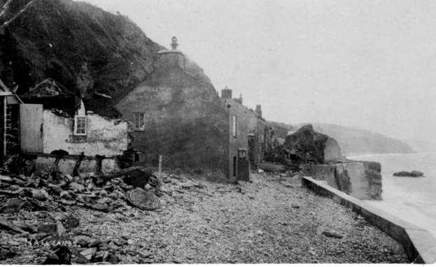
21 Nothing Nothing.. as 21

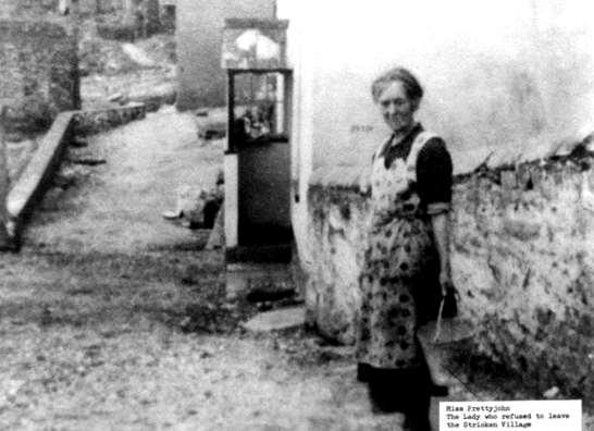
22 There was only one resident, Mrs. Elizabeth Prettejohn, left in Hallsands There was only one resident, Mrs. Elizabeth Prettejohn, left in Hallsands 22

23 On 26 January 1917, a combination of easterly gales and exceptionally high tides breached Hallsands' defences put up as a result of the storm of By the end of that year only one house remained habitable The U3A History Group are doing a future session specifically on Hallsands Question 14 The Cookworthy Museum building was constructed in the 17th Century for what purpose? The Free Grammar School was built and endowed in 1670 by Thomas Crispin, a Fuller of Exeter first headmaster - William Duncombe 23


24 Thomas Crispin in his will in 1689, left three yearly rent-charges: 5 a year for repairs 15 for the head master, in consideration of his teaching at least 15 free scholars in classical learning; and 10 to a master for teaching 25 poor children to read and 12 to write A native of Kingsbridge comes into the story in the next century William Cookworthy, born in 1705, the eldest of a family of seven It is possible that he was a pupil of Crispin's Grammar School The School remained in use until the early 1900's when the School itself moved further down in to the town and eventually in to a new building Old Kingsbridge Grammar School buildings 24


25 The museum was opened in 1972 in the old Kingsbridge Grammar School buildings by Mrs Evelyn Northcott who persuaded English China Clays Ltd. to rescue the derelict building The Museum was named after William Cookworthy Old Kingsbridge Grammar School buildings Question 15 What was William Cookworthy s claim to fame? William Cookworthy developed the first true hard-paste porcelain ( china ) to be made in this country rather than imported from China 25

26 William Cookworthy He was born in Kingsbridge in 1705 Eldest of a family of 7, William's father died when he was thirteen leaving the family in difficult circumstances His fortunes changed at the age of fifteen A Quaker apothecary - Silvanus Bevan offered to take the boy into his London business William set out on foot for London to take up this offer Returned to Devon in about 1726 William set up in business with Silvanus Bevan as a manufacturing chemist, trading in Plymouth as 'Bevan and Cookworthy He took an interest in the geology of the area Discovered deposits of kaolin and petunse, essential components of true porcelain, The U3A History Group are doing a future session specifically on William Cookworthy Question 16 Why was Tacket Wood or Ticket Wood so called? 26
, ships found it easy to berth and take on their loads.")
 joins the main Kingsbridge Estuary, which is")

27 Tacket or Ticket Wood is located in the parish of West Alvington Originally a wood Opened as a slate quarry, it produced large coarse slates and good stone for general purposes Since its last workings in the 19th C. it reverted to thick woodland Being on the creek side of the old road to Salcombe and away from the sea (e.g. Beesands), ships found it easy to berth and take on their loads. also one of four local venues for meetings led by John Hicks, the nonconformist preacher Others being Sorley Green, the top of Lincombe Hill/Linkham Hill-head and Saltstone Rock Salt Stone is an area of rock, isolated at high tide, off Wareham Point, where Frogmore Creek (on the left) joins the main Kingsbridge Estuary, which is between the rock and Lincombe Boat Yard beyond The area became known as Ticket Wood because attendees had to prove their adherence to nonconformist faiths Preachers became victims of the Conventicles Act of 1664 that forbade religious assemblies of more than five people outside the auspices of the C of E 27
28 Troublous times; or, Leaves from the note-book of the rev. mr. John Hicks Preachers were avidly prosecuted by two local magistrates Brutally supported by their town constable John Lucas Constable John Lucas died in 1671 and Hicks was accused of his murder and imprisoned at Exeter for a time Hicks left Devon and later joined the Duke of Monmouth s rebellion and was executed in 1685 Two other magistrates, more merciful ended up being prosecuted for not suppressing religious assemblies 1689, the Act of Toleration was passed, so people, excluding Catholics and Unitarians, were permitted to practice their religion and build churches Question 17 Where in Kingsbridge were the barracks built to house militiamen for the Napoleonic War in 1804? Early 19th Century Army Barracks, Dodbrooke Temporary barracks was built on land on the east side of the estuary about ½ mile west of High House They held 600 men and various regiments occupied them during the war It was removed after the Napoleonic War except for the hospital and gun room. The bakehouse formed part of Ivy Cottage and Windsor Lodge was built in one of the fields in 1818 Most of the materials of the structures were auctioned off in


29 Question 18 Can you name one of the paddle steamers which was a forerunner to the Rivermaid? The passenger vessel 'Rivermaid' operates between Kingsbridge and Salcombe during the summer months There were 9 paddle steamers Salcombe Castle Ilton Castle Kenwith Castle The Express Reindeer Ringleader Queen Kings Bridge Kingsbridge Packet A steamer from Salcombe bound for Kingsbridge 29


30 Question 19 When did the railway come to Kingsbridge? December 1893 Kingsbridge railway station was the terminus station of the single track branch of the GWR line from Brent to Kingsbridge The line became known as the Primrose Line It left the Brent to Plymouth line at Brent and ran 12 miles, following the route of the River Avon to Kingsbridge A proposed extension to Salcombe was not constructed 30


31 A stone built station served the town and the surrounding area. Despite a great deal of local opposition, the station was closed for freight and passengers on 16 September 1963 Kingsbridge Station, with a '4575' 2-6-2T. View eastward, towards the buffer-stops: The locomotive, No (built 11/28, withdrawn 10/60) is running round the branch train standing at the platform. Kingsbridge Station forecourt in c note the coach meeting the train to take tourists on to Salcombe Question 20 In the first part of the 20th century before Quay House became the home of Kingsbridge Town Council, it was occupied by girls, why? Quay House was built in 1789 by the Ilbert family In 1902 it became Twyford School for Girls for about 50 years In the 1970s it became the premises for Kingsbridge Town Council In the grounds of Quay House is the stone base of the Victorian drinking fountain which used to stand on the quay 31

32 Question 21 What is the special ingredient of white ale once brewed in Kingsbridge? The history of Devon white ale is shrouded in mystery and confusion Devon white ale seems to bear no relation to any other known beer style It has frequently been claimed that it was confined to the South Hams, yet in the mid-nineteenth century it was brewed in at least 44 Plymouth pubs A bone of contention is the so-called secret ingredient Some sources state categorically that the recipe was known only to the members of one family and handed down from generation to generation Others imply it was common knowledge As to where it was first brewed, although Dodbrooke (now part of Kingsbridge) is the name that most frequently crops up, Dartmouth, Plymouth and even Germany have also been suggested 32

33 first, dubious, reference to white ale comes in Andrew Boorde s Dyetary of Health 1736 first unequivocal reference to White Ale comes in William Ellis s London & Country Brewer, the Plymouth people are so attach d to their white thick ale, that many have undone themselves by drinking it Unlike Boorde, Ellis gives details of how this seductive tipple was brewed White ale is a clear wort made from pale malt fermented with ripening, a composition of: Flour of malt, yeast, and whites of eggs [a nostrum (medicine prepared by an unqualified person) is made and sold only by two or three in these parts] The wort is brewed and the ale vended by many of the publicans It is drank while it is still fermenting in earthen steens, in such a thick manner as resembles butter d ale Sold for two pence-halfpenny the full quart Question 22 Which is the oldest family retailer in Kingsbridge? Does this help? 33


, that is to say an estate in land, for the use of a")

34 J. H. Donovan & Son Ltd is known as the oldest family run business in Kingsbridge John Donovan John Henry Donovan Exact date of the opening not recorded John Weymouth Donovan John Nicholas Donovan Known to have been in 1873, original John Donovan started trading as a china shop at the top of Church Street, This property is long gone, pulled down and cottages built The U3A History Group are doing a future session specifically on the Donovan family Question 23 Who are the Feoffees? A feoffee is a trustee who holds a fief (or "fee"), that is to say an estate in land, for the use of a beneficial owner The term is more fully stated as a feoffee to uses of the beneficial owner The use of such trustees developed towards the end of the era of feudalism in the middle ages and became obsolete with the formal ending of that social and economic system in
35 Kingsbridge Feoffees The Feoffees were, and still are, the trustees of the property which had been given to the town in order that the profits arising from it might be used for charitable purposes. The properties were mainly houses and shops, with gardens and closes, in Kingsbridge and Dodbrooke. There were also lands at Ford in Chivelstone, at Fursdon in Sherford and at Merrifield in Churchstow Their coat of arms can be seen above the entrance of the Town Hall, the Market Hall and 20 Fore Street General feed back (See below) Please take a few minutes to discuss if any of these might be of interest for future Society meetings? Ones planned (See next page) 35
36 General feed back 1. Where would you find a Celtic hilltop fort close to Kingsbridge? 2. After the Norman invasion of 1066 who became the major land owners of the lands around Kyngysbrygge, or as it is better known, Kingsbridge? 3. Henry the VI issued a charter in the mid 15th century to allow Kingsbridge to hold some event weekly and annually, what was it? 4. To the nearest 10, how many houses were reported in Kingsbridge in the mid 1600 s? 5. What was the previous name for the Crabshell area? 6. What is a Turnpike Trust? 7. Why did the shipyards in Kingsbridge Close and, for an extra point, when did they close? 8. What was the effect of the blizzard of 1891 in South Hams? 9. Here is one especially for those avid gardeners. What was grown for the first time in the UK on the terrace of the former Cliff House at Salcombe built in 1842? 10. Which famous US (and worldwide) religious leaders ancestors were tenant farmers of Stancombe manor? 11. What happened in Aveton Gifford on Tuesday 26 January 1943? 12. What happened at Torcross in 1854 and what was the big upside? 13. What would the residents of Hall sands say in 1918? 14. The Cookworthy Museum building was constructed in the 17th Century for what purpose? 15. What was William Cookworthy s claim to fame? 16. Why was Tacket Wood or Ticket Wood so called? 17. Where in Kingsbridge were the barracks built to house militiamen for the Napoleonic War in 1804? 18. Can you name one of the paddle steamers which was a forerunner to the Rivermaid? 19. When did the railway come to Kingsbridge? 20. In the first part of the 20th century before Quay House became the home of Kingsbridge Town Council, it was occupied by girls, why? 21. What is the special ingredient of white ale once brewed in Kingsbridge? 22. Which is the oldest family retailer in Kingsbridge? 23. Who are the Feoffees? Neil Martin January
Morgan s Vale and Woodfalls History Trail. (You could start at any point and follow the trail round)
") Morgan s Vale and Woodfalls History Trail (You could start at any point and follow the trail round) 1) MORGAN S VALE & WOODFALLS PRIMARY SCHOOL Built in 1869, it served as a church on Sundays until the
Morgan s Vale and Woodfalls History Trail (You could start at any point and follow the trail round) 1) MORGAN S VALE & WOODFALLS PRIMARY SCHOOL Built in 1869, it served as a church on Sundays until the
PASSIVE VOICE. Sightseeings of London
 PASSIVE VOICE. Sightseeings of London The project has been done by the students of the 9 th form: Akhmetvaleeva Julia Murzakhanov Ilgiz Tatar gymnasium 14 How often do we use Passive Voice? We use it everywhere,especially
No 2 Ketts height WalK
 Pub Walks around Norwich No 2 Ketts height WalK Introduction This second walk, which like the first is circular, also starts and ends at Norwich (Thorpe) Railway Station but takes in a very different part
Berkhamsted and Hemel Hempstead from Iver Marina
 UK Canal Boating UK Canal Boating Escape with a canal boating holiday! Telephone : 01395 443545 Email : contact@ukcanalboating.com Booking Office : PO Box 57, Budleigh Salterton. Devon. EX9 7ZN. England.
Cadburys World Warwick Castle from Alvechurch
 UK Canal Boating UK Canal Boating Escape with a canal boating holiday! Telephone : 01395 443545 Email : contact@ukcanalboating.com Booking Office : PO Box 57, Budleigh Salterton. Devon. EX9 7ZN. England.
Burderop Park.
 Burderop Park Welcome to City & Country s Public Consultation about its proposals to restore Burderop Park which lies on the edge of the Marlborough Downs, within the North Wessex Downs Area of Outstanding
Channel Islands Occupation Society
 INTRODUCTION The subject of the Conservation Statement is Kempt Tower, built in 1834 in St Ouen s Bay, Jersey. The primary purpose of the statement is to draw together existing information, to set down
The Princes In The Tower By Alison Weir
 The Princes In The Tower By Alison Weir The Princess In The Tower video from Bloody Tales exclusively on National Geographic Channel. The Princes in the Tower is one of England's most notorious cold cases
THE BOATHOUSE. Beacon Road Kingswear Devon TQ6 0BS
 THE BOATHOUSE Beacon Road Kingswear Devon TQ6 0BS THE BOATHOUSE Beacon Road Kingswear Devon One of the most iconic waterfront houses in Kingswear Dartmouth across the River Dart and serviced by three
Gors Lydan barrows and medieval huts
 Walk Information: Maps: OS Explorer 214 Distance: 5.5 miles / 9 kilometres Duration: 4.5 to 5 hours Difficulty: Easy. Good paths and no steep gradients Start and finish: SO 11977545 Walk summary The walk
Coast Path Survey Stretch 09 Shalfleet Mill to Thorness Bay
 Coast Path Survey Stretch 09 Shalfleet Mill to Thorness Bay Overview Map of stretch Introduction This stretch of Island coast covers several salt marsh creeks backed by grazing land and woodland on the
A walk around old Ardersier
 A walk around old Ardersier Ardersier Local History Group 2014 Welcome to our Ardersier village walk We hope you enjoy your tour and that the weather is dry! Allow an hour for a leisurely stroll: the
HISTORIC SITES START WINDSOR CASTLE 10M. Queen Elizabeth II. Statue. The Royal Chapel 9M. The Royal Lodge. Virginia Water.
 WINDSOR CASTLE HISTORIC SITES Queen Elizabeth II Statue The Royal Lodge The Royal Chapel 9M Virginia Water 10M 2M Cumberland Lodge 3M Prince Consort Statue Copper Horse Statue 1M The Royal School 7M START
The Atlas of Hillforts of Britain and Ireland. Hillfort survey notes for guidance
 The Atlas of Hillforts of Britain and Ireland Hillfort survey notes for guidance The collection of surveys for the Atlas is now finished but you can use this form and the accompanying Notes for Guidance
There are many information panels hidden between the buildings and the newer ones are made of brick. The old medieval structures are made from stone.
 There are many information panels hidden between the buildings and the newer ones are made of brick. The old medieval structures are made from stone. The monk sculpture is near the woodland but also has
Cedar Cottage, Riverside Road East, Newton Ferrers, Plymouth, Devon, PL8 1AE
 Cedar Cottage, Riverside Road East, Newton Ferrers, Plymouth, Devon, PL8 1AE Cedar Cottage, Riverside Road East, Newton Ferrers, Plymouth, Devon, PL8 1AE Plymouth 9 miles, Salcombe 20 miles, Dartmouth
Baslow & Bubnell Page 1 of 5 A Comparison
 Baslow & Bubnell Page 1 of 5 Introduction This paper describes the number of houses in Baslow and Bubnell from 1670 up to the present day. Most of the data was obtained by counting the buildings on a series
Quiet Beverley - A walk with Val Wise. May and June 2018
 Quiet Beverley - A walk with Val Wise May and June 2018 This was one of two walks in May and June with half the group going on each and then swapping over to attend the other one. I joined Val in the Library
Walking in my Fore father's Footsteps
 Walking in my Fore father's Footsteps by Victor T.D. Holliday As part of the introduction to Local Mining History it falls upon me to undertake research that reflects my personal interest in mining history.
Major Battles During WWII Events that Changed the Course of the War
 The Battle of Britain Major Battles During WWII Events that Changed the Course of the War With all of Europe under its control, as the last hold out The English Channel is only at the most narrow point
The Trooper Potts HERITAGE TRAIL. A walk around Central Reading
 The Trooper Potts HERITAGE TRAIL A walk around Central Reading This trail starts at the north side of Reading Station and concludes on the south side. As you follow it you will learn something of the
A leisurely one mile stroll through the history of Aldershot s Manor park, considered by many as the most attractive and pleasant parts of our town.
 Figure 1 Entrance to Park from the Aldershot Green/Churchill road end A leisurely one mile stroll through the history of Aldershot s Manor park, considered by many as the most attractive and pleasant parts
Lost Colony of Roanoke
 Lost Colony of Roanoke Lesson Number: 3 Title: The Lost Colony of Roanoke Grade Level: 5 th Time: 50-60 minutes Materials: Per Student: Roanoke: The Lost Colony short story Roanoke Theories worksheet Evidence
The Changing Face of Bonnersfield and Sheepfolds Area of Monkwearmouth
 The Changing Face of Bonnersfield and Sheepfolds Area of Monkwearmouth What was the origin of these names? They were obviously rural and farming related but by the 18 th century the land was becoming industrialised.
ISOM & ISSOM forbidden symbol comparison
 & forbidden symbol comparison Forbidden symbols and their relatives Symbol 2000 (Long, Middle) 2007 (Sprint) 201 Impassable cliff An impassable cliff, quarry or earth bank (see 106) is shown with a 0.35
2. 4 Avebury: stone circles and nearby sites
 24 2. 4 Avebury: stone circles and nearby sites N E W S Beckhampton Avenue The bank originally stood 7 m (23 ft) high, much taller than today. The ditch was originally 9 m (30 ft) deep and 20 m (65 ft)
Athens and Sparta THE EARLIEST GREEK CIVILIZATIONS THRIVED NEARLY 4,000 YEARS AGO. YET THEIR CULTURE STILL IMPACTS OUR LIVES TODAY.
 Athens and Sparta THE EARLIEST GREEK CIVILIZATIONS THRIVED NEARLY 4,000 YEARS AGO. YET THEIR CULTURE STILL IMPACTS OUR LIVES TODAY. What happened after the Mycenaeans? After the fall of the Mycenaeans,
Stories from Maritime America
 Spud Campbell Spud Campbell describes the sinking of the Liberty ship SS Henry Bacon by German aircraft on February 23, 1945. Sixteen merchant mariners and twelve members of the Navy Armed Guard were killed
The Demise of the S S Belem
 The Demise of the S S Belem The S S BELEM ran ashore in fog at Menachurch Point, a little to the north of Northcott Mouth, Bude on the night of 20 th /21 st November, 1917. She was originally named the
MODEL RAILWAYS ON-LINE EXETER CENTRAL. Described by Ken Webb. Photographed by Paul Plowman. Photograph by David Taylor
 - EXETER CENTRAL Described by Ken Webb Photographed by Paul Plowman Photograph by David Taylor 2 Exeter Central Ken Webb describes his layout based on Exeter Central Photographs by Paul Plowman My layout
THE BRITISH ISLES AND NORDIC NATIONS. Chapter 15
 THE BRITISH ISLES AND NORDIC NATIONS Chapter 15 A LITTLE CONFUSING. UK refers to the political union between the countries. -Sovereign state but nations are also individual countries. Great Britain is
U3A WALK Harby Hose. Route Summary. Route Overview. Description. Waypoints. Harby. Stuart Galloway
 U3A WALK Harby Hose Stuart Galloway Route Summary A circular walk taking in Harby, Hose and the Grantham Canal. Route Overview Category: Walking Length: 7.310 km / 4.57 mi Parking: Village Hall School
w w w. d r a k e s - i s l a n d. c o m
 w w w. d r a k e s - i s l a n d. c o m 1 A Piece of History Named after Plymouth s most famous patron and situated in the heart of Plymouth Sound, Drake s Island has a rich history having been a religious
Student Activities. Dead Man s Folly. Part 1 (Chapters 1 3) 3 Vocabulary Match the words on the left with their definitions on the right.
 3 Vocabulary Match the words on the left with their definitions on the right.") Part (Chapters ) Vocabulary Complete the labels on the map of Nasse House. KEY Woodland and bushes Station Hoodown Park Front gates Drive ennis court Nasse House ea tent Upper garden Fortuneteller s tent
Part (Chapters ) Vocabulary Complete the labels on the map of Nasse House. KEY Woodland and bushes Station Hoodown Park Front gates Drive ennis court Nasse House ea tent Upper garden Fortuneteller s tent
WHITBY HERITAGE TRAIL
 TEACHER s PACK KEy stage 2 & 3 WHITY HERITAGE TRAIL This trail and its associated activity sheets are to allow you and your students to explore the town of Whitby and discover more about its history and
Beautiful Walks from the Blue Ball Inn
 Walk No. 5 RIVER VALLEYS AND MOOR Countisbury, Watersmeet, Hillsford Bridge, Cheriton, Shilstone Hill, Rockford and Chiselcombe. 8.5 MILES APPROX. Walking time four and a half hours approx. OS 1;25,000
Section 1: Vocabulary. Be able to determine if the word in bold is used correctly in a sentence.
 Section 1: Vocabulary. Be able to determine if the word in bold is used correctly in a sentence. Hardships: difficult conditions or situations that cause discomfort and/or suffering Pioneers: the people
WALKS AROUND WOODHURST
 WALKS AROUND WOODHURST With Walks To Woodhurst from North St. Ives Woodhurst is situated on the verge of an elevated tract of table land four miles north of St. Ives. Its footpaths vary from leafy lanes
FOUNDATIONS OF ARCHAEOLOGY A WALK IN VERNDITCH CHASE
 FOUNDATIONS OF ARCHAEOLOGY A WALK IN VERNDITCH CHASE 1. A Tale of two Long Barrows Long barrows were constructed as earthen or drystone mounds with flanking ditches and acted as funerary monuments during
Places in Brent. Stonebridge. Grange Museum of Community History and Brent Archive
 Places in Brent Stonebridge Grange Museum of Community History and Brent Archive Stonebridge is situated in southern Brent, on the Harrow Road between Harlesden and Wembley. The 17 th and 18 th centuries
Chapter 3. The English Colonies
 Chapter 3 The English Colonies Terms 1. Indentured servants 2. Cash crops 3. Assembly 4. Puritans 5. Mayflower Compact 6. Slave trade 7. Fundamental orders Massachusetts- 1630 Founders- William Bradford
Burgos lies on the main highway from France to
 Burgos Then and Now: the Sierge of 1812 By Gareth Glover The Napoleon Series BURGOS IN 1812 Burgos lies on the main highway from France to Valladolid, at a point where the road south to Madrid forks off.
24 EARL STREET WALKING TOUR
 24 EARL STREET WALKING TOUR This walk covers four city blocks of Earl Street, one of the oldest streets in Kingston. APPROXIMATELY 45 MINUTES Please be respectful of private property. 24 EARL STREET WALKING
Orchards and oasts a taste of the Garden of England
 49 Orchards and oasts a taste of the Garden of England Open parkland, orchards, oasts and incredible panoramic views over the Weald to the South Downs make this a truly memorable walk. Linton Village 50
Scheduled Monument (SM90085) Taken into State care: 1966 (Guardianship) Last reviewed: 2004 CROOKSTON CASTLE
 Taken into State care: 1966 (Guardianship) Last reviewed: 2004 CROOKSTON CASTLE") Property in Care (PIC) ID: PIC119 Designations: Scheduled Monument (SM90085) Taken into State care: 1966 (Guardianship) Last reviewed: 2004 HISTORIC ENVIRONMENT SCOTLAND STATEMENT OF SIGNIFICANCE CROOKSTON
Property in Care (PIC) ID: PIC119 Designations: Scheduled Monument (SM90085) Taken into State care: 1966 (Guardianship) Last reviewed: 2004 HISTORIC ENVIRONMENT SCOTLAND STATEMENT OF SIGNIFICANCE CROOKSTON
Economy 3. This region s economy was based on agriculture. 4. This region produced items such as textiles, iron, and ships in great quantities. For th
 Geography 1. This region has a climate of warm summers and snowy cold winters. 2. This region has a climate that is generally warm and sunny, with long, hot, humid summers, and mild winters, and heavy
The Last resting Place of George and Anne Goodison
 The Last resting Place of George and Anne Goodison Some years ago, I published an article concerning the life of the man who gave his name to the home ground of Everton FC and made an unqualified assumption
Discovery Trail. outstanding natural beauty.
 Discovery Trail Discover the Tamar Valley Area of Outstanding Natural Beauty along this 30-mile walking route. Waymarkers guide you through scenic woodland, historic river quays and rural villages. outstanding
Hannibal crosses the Alps
 Hannibal crosses the Alps 247-182 BC Early years Hannibal Barca was born in Carthage, North Africa, (now a suburb of Tunis, Tunisia) in 247 BC. At that time this once prosperous seaport was losing a long
The Spanish Armada. by: Austin Hartman
 The Spanish Armada by: Austin Hartman Was the Spanish Armada worth it for Philip II? Key People Philip II- King of Spain Queen Elizabeth I- Queen of England Sir Francis Drake- Loyal subject to Queen Elizabeth
PHOTO BOOK OF OUR SCHOOL TRIP TO ENGLAND. London Brighton Portsmouth Hastings. Sunday, April 29th - Saturday, May 5th 2018
 PHOTO BOOK OF OUR SCHOOL TRIP TO ENGLAND London Brighton Portsmouth Hastings Sunday, April 29th - Saturday, May 5th 2018 What a rough crossing! London London Monday, April 30th Monday, April 30th We arrived
Castleton and Its Old Inhabitants.
 Castleton and Its Old Inhabitants. Chapter 6. The Churchyard-side buildings on Castle Street. Part of Castle Street has changed somewhat over the years, mainly due to the earlier presence of a little row
Middle Row: Part of a Georgian Industrial Settlement in Cark in Cartmel, Cumbria Les Gilpin
 Middle Row: Part of a Georgian Industrial Settlement in Cark in Cartmel, Cumbria Les Gilpin The Georgian rows of of High Row and Low Row which sit alongside ' Cark Beck' (river Eea) in the hamlet of Cark
Woodland Walk If you enjoyed this walk there are two others available in the same area.
 The Woodland Walk 11-12 kilometres (7-8 miles) 4-5 hours Terrain: some easy hills Can be slippery when wet 5 stiles Unsuitable for a pushchair/wheelchair Uses OS map 197 Parking: Pulborough Station and
Newsletter - Winter 2017
 Newsletter - Winter 2017 Our next talk 'Pinebanks - the house and its history' by John Balls' Thursday 16th February - at the There will be a charge of 3 per person. Recent Events We have been enjoying
The Sand House A Victorian Marvel
 The Sand House A Victorian Marvel A talk given by Richard Bell to Tickhill & District Local History Society in April 2007 The majority of Doncaster s 21st Century residents are oblivious to the unique
The Tower of London. Did you know?
 The Tower of London The first part of the Tower of London was built by William the Conqueror in 1078 but what we now call the Tower is actually a collection of several different buildings. The Tower of
The protected site of Street, huddled under Berry Hill. 27, a pre-world War I view shows much more thatch on the roofs than the later picture, taken
 25 The road to Street (in the distance) shows extensive allotments on the south side of Culverwell Hill the scene of a murder in 1883 (see The Shooting at Branscombe Old Pits by Barbara Farquharson and
The Hundred Parishes
 The Hundred Parishes Walks from railway stations number 3 3 miles (5kms) circular walk from Stansted Mountfitchet Start & finish: Stansted Mountfitchet station. Ordnance Survey Explorer Map 195. Grid Reference:
The Landscape of the English Part of the Via Francigena. Oliver Rackham Corpus Christi College, Cambridge
 The Landscape of the English Part of the Via Francigena Oliver Rackham Corpus Christi College, Cambridge The Straits of Dover are thought to have been formed three glaciations ago (about 400,000 years)
archeological site LOS MILLARES
 archeological site LOS MILLARES Aerial view of the plain of Los Millares between the Rambla de Huéchar and the River Andarax The archaeological site of Los Millares is located in the township of Santa
The Battle of Quebec: 1759
 The Battle of Quebec: 1759 In the spring of 1759, the inhabitants of Quebec watched the river with worried eyes. They waited anxiously to see whether the ships of the French, or those of the British fleet,
living with iconic heritage at the historic
 WELCOME TO The Ram Quarter at Wandsworth. An exciting new residential and retail quarter, combining contemporary living with iconic heritage at the historic Young s Brewery site. 01 INTRODUCTION Stylish
Hayle Harbour Trust, Ltd. Past, Present and Future
 Hayle Harbour Trust, Ltd. Past, Present and Future 2009, Peter Channon The History Since before De Savary, attempts have been made to gain local control of the harbour. When ING took control (through default,
Doctor Richard Hungerford Townsend [5A02]
![Doctor Richard Hungerford Townsend [5A02]](/thumbs/94/120539477.jpg "Doctor Richard Hungerford Townsend [5A02]") Doctor Richard Hungerford Townsend [5A02] Richard on one of his many fishing trips Richard s wife, Arabella Jane Denny Trinity College, Dublin The Titanic Cobh Extract from Samuel Lewis Topographical Directory
Doctor Richard Hungerford Townsend [5A02] Richard on one of his many fishing trips Richard s wife, Arabella Jane Denny Trinity College, Dublin The Titanic Cobh Extract from Samuel Lewis Topographical Directory
Name: Class: Unit: Modern Novel Yr8 - Blitzed
 Name: Class: Unit: Modern Novel Yr8 - Blitzed Use this page as a reading log You will have to read approx 8-10 pages per lesson to get through the book in time. The first half of each lesson will be reading
Britain s oldest surviving water-balanced cliff lift
 44 3.6 Saltburn by the Sea to Sandsend Map panels 3 and 4 Distance 17 miles (27½ km) Terrain mostly grass and field paths which can be muddy; some pavement, beach and shore Grade undulating route, with
Self-Guided Walk Langdale Pikes. Start & Finish: NT car park (free to members) at Sticklebarn - on the right just beyond the New Dungeon Ghyll hotel.
 at Sticklebarn - on the right just beyond the New Dungeon Ghyll hotel.") Self-Guided Walk Langdale Pikes Key Information These mountains form a collection of spires and cliffs on the north side of Langdale. This walk visits four of the main tops Pavey Ark, Harrison Stickle,
Self-Guided Walk Langdale Pikes Key Information These mountains form a collection of spires and cliffs on the north side of Langdale. This walk visits four of the main tops Pavey Ark, Harrison Stickle,
Centurions Spring walk 22 nd March 2014
 Centurions Spring walk 22 nd March 2014 Where Romans once stood; a walk around Canvey Island When the Romans needed salt they came to Canvey Island. As Centurions we will walk upon the Islands soil and
Introduction to Map 14: Fionn-phort to Caol Ila
 Introduction to Map 4: Fionn-phort to Caol Ila This map section covers some 3.8km of coastline. In the southern and central part of this section the landscape is dominated by open moorland, with scrub
Baker Street Elementary & Victorian-ERA.org Presents The Life and Times in Victorian London
 Baker Street Elementary & Victorian-ERA.org Presents The Life and Times in Victorian London Baker Street Elementary & Victorian ERA.org The Life and Times in Victorian London # 200 Victorian Era Timeline
Mersey Valley Timberland Trail
 Route Pack Page 1 Route Summary A long distance linear walk on roads and country paths linking town and countryside to parks, woodlands and other open spaces. Grade Distance Accessibility Allow Start Map
Riverside. Riverside Heritage Trail. Heritage Trail STRATFORD-UPON-AVON STRATFORD-UPON-AVON. Stratford Historic Buildings Trust. Further information
 STRATFORD-UPON-AVON Riverside Heritage Trail Further information Websites stratfordhbt.co.uk stratfordsociety.co.uk shakespeare.org.uk STRATFORD-UPON-AVON Riverside Heritage Trail Books The Buildings of
D-Day. June 6th, 1944
 D-Day June 6th, 1944 The Move on to France Because the Germans were being fought in Italy, the allies planned to move forward with their plan to open up the western front in Europe The Plan Winston Churchill
Standing at the Edge of the Pale
 Nobber Oldcastle Kells Athboy Navan Slane River Boyne Drogheda Newgrange Donore Duleek Bettystown Laytown Mosney Trim Hill of Tara Dunshaughlin Ratoath N1 Summerhill N2 Galway Belfast Dublin Enfield Kilcock
The South East and the Midwest of England Tour of Castles and Mansions
 Welcome to The South East and the Midwest of England Tour of Castles and Mansions Explore and Feel the History A 14 day packaged Tour starting August 30, 2019 Leave your luggage at a Hotel location and
Newsletter - Winter 2015
 Newsletter - Winter 2015 Recent activities Our last talk of 2014 was held in November, just before the country marked Armistice Day, and was rather appropriately entitled "Thorpe in World War One" when
26 North Water Street N A N T U C K E T. A House History
 26 North Water Street N A N T U C K E T A House History North Water near Easton Street looking east, circa 1870. 26 North Water is third house on the right. A Brief History 26 North Water Street 26 North
50 WALKS IN DEVON 50 WALKS IN DEVON 50 WALKS IN DEVON PDF BEER, DEVON - WIKIPEDIA DEVON TRAVIS - WIKIPEDIA 1 / 5
 PDF BEER, DEVON - WIKIPEDIA DEVON TRAVIS - WIKIPEDIA 1 / 5 2 / 5 3 / 5 50 walks in devon pdf Beer is a village and civil parish in the East Devon district of Devon, England. The village faces Lyme Bay
Figures in the Folk Museum
 Figures in the Folk Museum An interactive learning experience at the Ulster Folk & Transport Museum. Meet some of the characters who live in Ballycultra town, listen to their story and use their knowledge
Booklet Number 178. SAMUEL McGREGOR. This booklet remains the property of Saint Andrew s Uniting Church. Please see a Guide if you would like a copy.
 Booklet Number 178 SAMUEL McGREGOR 1884 1953 This booklet remains the property of Saint Andrew s Uniting Church. Please see a Guide if you would like a copy. 2 Saint Andrew s Uniting Church Corner Ann
ROYAL NATIONAL PARK. The Royal National Park was the second national park in the world, after Yellowstone in the United States.
 ROYALNATIONALPARK TheRoyalNationalParkwasthesecondnationalparkintheworld,after YellowstoneintheUnitedStates. Thefirsttennationalparksintheworld. Becauseitwassuchanearlynationalpark,theauthoritieswerenotsure
From the castle, you can look out at the sea or the firth too.
 Scotland and Ireland trip (June24-July 12, 2005) Part 1. Scotland We flew to Edinburgh through Manchester. On the first day, we met our friends from London at the Edinburgh castle. This is a charming city,
PHOTOBOOK OF OUR SCHOOL TRIP TO ENGLAND
 Collège les Mailheuls COURSAN PHOTOBOOK OF OUR SCHOOL TRIP TO ENGLAND Sunday, April 29 th - Friday, May 4 th 2018 What a rough crossing! London Monday, April 30 th We arrived in London around 10 am in
History of Bluebell, Poppy and Tally Ho!
 History of Bluebell, Poppy and Tally Ho! LHG Meeting 16 th September 2015 Introduction Some time ago I came across a write-up about Tally Ho! buses and thought it would be an interesting topic for an LHG
Yealm Ridge 97 COURT ROAD NEWTON FERRERS DEVON
 Yealm Ridge 97 COURT ROAD NEWTON FERRERS DEVON Yealm Ridge 97 COURT ROAD NEWTON FERRERS DEVON An exciting Stan Bolt-designed development opportunity to build a three bedroom detached waterfront property
Rochdale Road & Thorn
 Copyright bacuptimes.co.uk Rochdale Road & Thorn Rochdale Road was not always as we know it today if a traveller wanted to get to Rochdale from Bacup his journey would begin in the centre of Bacup whereupon
BOROUGH of WEST DEVON HIGHAM PTON. the. parish plan
 BOROUGH of WEST DEVON HIGHAM PTON the parish plan Table of Contents Front Cover Page 1 Page 2 Images of Highampton Top Left Approaching from the West Top Right The Golden Inn Bottom Left Burdon Lane Bottom
Future Economy. Future Econo. Conditions for Growth. Conditions for Growth. Growth for Business. Growth for Business. Isles of Scilly.
 Isles of Scilly Evidence Base Future Economy Future Economy Conditions for Growth Conditions for Growth Growth for Business Growth for Business Future Econo CONTENTS Introduction... 3 Economic Overview...
Limestone terraces (in the distance) and woodland on hills in the Upper Wharfedale valley
 and woodland on hills in the Upper Wharfedale valley") GRASSINGTON North Yorkshire from www.discoverbutterflies.com the website for the book Discover Butterflies in Britain D E Newland 2009 Limestone terraces (in the distance) and woodland on hills in the
GRASSINGTON North Yorkshire from www.discoverbutterflies.com the website for the book Discover Butterflies in Britain D E Newland 2009 Limestone terraces (in the distance) and woodland on hills in the
Pen Cerrig-calch prehistoric cairns
 Walk Information: Maps: OS Explorer OL13 Distance: 8 miles / 13 kilometres Duration: Allow at least 6 hours for the circular walk Difficulty: medium. Some narrow paths, occasionally rough underfoot Start
Report from Marcel Meier Dog-handler sub-commission regarding the dog-handler gathering that be held by Marcel last winter.
 Avalanche commission report Killarney Ireland 2015 Oct. Practical day : Presence of the President of the avalanche commission. Assembly of Delegates of the Avalanche Rescue Commission: Welcome / Meeting
SAINT OSWALD S CHURCH. In the Parish of Hinstock
 SAINT OSWALD S CHURCH ( The stone Church with the warm heart ) In the Parish of Hinstock Introduction A road ran through Hinstock as long ago as Roman times when the springs which currently fill the Bearcroft
There is some dispute about the original date of this historic building, but whether it be 1732 or 1750, the fact remains that it stood before our
 Cornwall, NY There is some dispute about the original date of this historic building, but whether it be 1732 or 1750, the fact remains that it stood before our Nation began and holds historic significance
English Country Church Calendar 2008 Continental visitors famously referred to England as the ringing island as you were never out of earshot of
 English Country Church Calendar 2008 Continental visitors famously referred to England as the ringing island as you were never out of earshot of church bells. There are of course the well-known great churches
Images: ThinkStock
 The frontline trenches were made up of three different trenches. These were the fire line, the support trench and the reserve trench. Communication trenches joined them together. Trenches were meant to
How the Nile River Led to Civilization in Ancient Egypt
 How the Nile River Led to Civilization in Ancient Egypt By USHistory.org on 03.07.17 Word Count 1,108 Level MAX TOP: This photo, taken around 1915, shows the flooding of the Nile River, which happens each
1: The Nile River Valley
 1: The Nile River Valley In Nubia and Egypt, the Nile flows through the Sahara, a vast desert that stretches across most of northern Africa. Before reaching Egypt, the river in ancient times roared through
Booklet Number 42 ALEXANDER EASTON. The 9th Battalion AIF marching through Queen Street, Brisbane, 1914.
 Booklet Number 42 ALEXANDER EASTON 1895 1954 The 9th Battalion AIF marching through Queen Street, Brisbane, 1914. This booklet remains the property of Saint Andrew s Uniting Church. Please see a Guide
Freefolk and Whitchurch
 Trail Activity Type Terrain Author Distance Ascent Location : HAMPTR0026 : Walk : Tea Shop : Towpaths and Cycle Tracks : Jean Patefield : 5.6 miles / 9 kms : 377 feet / 115 metres : SU487488 / RG28 7NN