Archaeologia Cantiana Vol ( 35 )
|
|
|
- Dwain Harmon
- 6 years ago
- Views:
Transcription
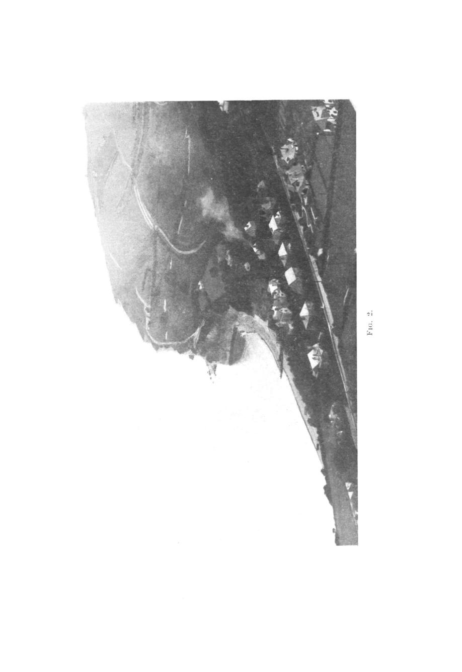
1 Archaeologia Cantiana Vol ( 35 ) ST. MARGARET'S BAY, AND THE ROMAN ROADS FROM RICHBOROUGH TO DOVER AND CANTERBURY. BY CECIL KNOX. IN 1769 Andrews, Dury and Herbert published their map of Kent on a scale of 2 in.=l mile. A photograph of a part of this map is given in Fig. 1. There are at least three matters on this map which, I think, call for comment. I. ST. MARGARET'S BAY. An aerial photograph of the bay is shown in Fig. 2. As Fig. 1 is on such a small scale, Fig. 3 is given on the same scale as Andrews' map. It shows a delightful little harbour at high tide similar to Lulworth Cove. Local tradition knows nothing of this harbour. But it seems incredible that Andrews invented it. The map was produced under the patronage of the Lord Warden (Earl of Holdernesse) and other local notables. It is absurd to suppose that this harbour, with its pier, landing-stage and " Sea Gate, Right Angles with Calais ", could have been placed on the map if it had no existence. It seems, however, that within thirty years of the production of this map the harbour had disappeared. Fig. 4 is taken from the Admiralty Chart No. 738, " Deal to South Foreland ", by Graeme Spence, We may take it for granted that on such a chart the rocks shown at low water are correctly marked. When the chalk cliffs rose from these rocks there must have been some such harbour as that shown on Andrews' map. From the look of the grass-grown cliffs it is probable that the landward side of the bay is v.ery much the same now as it was 150 years ago. This enables us to compare Andrews' map with the present Ordnance Survey, so as to give us some idea of the rate of coast erosion at this point. It is obvious that such chalk

2 FIG * '
 (Fig.")
3 36 ST. MABGAKET'S BAY, promontories as those forming the Sea Gate could not survive many winter storms, but there seems to have been unusually rapid erosion at that time. Having enlarged Andrews' harbour to a 6-in. scale, and compared it with the 6-in. O.S. (1906) (Fig. 5), it is found that for a length of one mile, during the period , the cliff edge receded, on an average, about 300 feet, say two feet per annum. This is on the supposition that Andrews' map is reasonably correct. The rate of erosion is, of course, nothing like that now, but then the coast-line has become smoothed and straightened out, whereas in 1769 it appears to have been indented with bays and headlands. What the rate of erosion was before that date we do not know, but 1,800 years earlier St. Margaret's Bay must have been a very useful harbour. This harbour was formed by the submersion of the valley which we see descending from the lighthouse in Fig. 2, in a north-easterly direction. As it nears the shore it becomes steeper and narrower, being flanked by considerable cliffs where it enters the sea. It seems, then, probable that in Roman times the harbour was narrow, and enclosed by cliffs. On August 26th, 55 B.C., Caesar, waiting for his transports to come up, anchored according to Bice Holmes off the South Foreland. " The formation of the ground", Caesar tells us, " was peculiar, the sea being so closely walled in by narrowing cliffs (montibus angustis) that it was possible to throw a missile from the ground above on to the shore." This seems to be entirely in keeping with the suggested harbour. It is interesting to note that the local branch of the Pilgrims' Way continues through Canterbury as far as Studall, in a direction making straight for this harbour. II. THE ROMAJT ROAD TO DOVER. Next, returning to Andrews' map, let us see what he makes of the Roman road from Wodensborough to Dover. We find that nearly alt the road is marked on the map, but so faintly that they have been inked in on the photograph
4

5 'a Gate- * Angle tvitji Calais 4 oxith Foreland FIG. 3. FIG. 4. Fig. 3. St. Margaret's Bay 1760, same size as Andrew's map. Fig. 4. St. Margaret's Bay 1795, with 3 superimposed. Fig. 5. St. Margaret's Bay 1906, with 3 superimposed and the eroded portion marked in 100 ft. squares.
.")
6 AND THE ROMAN ROADS. 37 (Fig. 1). It is evident that Andrews had not the least idea that he was dealing with a single, through and perfectly straight road. It was not till 1799, when the first O.S. Map of East Kent was surveyed, on the scale of 3 in.=l mile, that this road was shown as a continuous thoroughfare. The name " Roman Road " first appeared on the 25-in. O.S. ( ). Now, it is generally taken for granted that this road was intended to connect up Richborough with Dover, the part from Wodensborough northwards being entirely lost. On the other hand there are certain considerations connected with this road which suggest that possibly it was intended for another purpose. We know that in Roman times the Count of the Saxon Shore was appointed to protect the country from the marauding Saxons. We may take it for granted that he took all proper military precautions to attain this end ; amongst other things setting up observation posts at the proper places. The most important of these was on the hill at Wodensborough, for this is the only hill which commands an uninterrupted view of the whole coast from Ramsgate to Walmer, and the whole harbour to Reculver. At present trees block this view, but a visit to the church tower close by will confirm this statement. The bench-mark on the church, at a slightly lower level than the hill-top, is feet. Also, on the hill-top is a mound, marked " tumulus " on the 6-in. O.S., and an antiquity cross. This hill must have been the nerve-centre of the defence of this part of the coast. Now, every observation post must be provided with means for the rapid despatch of information to those concerned. To-day it is telephones. In Roman times it was paths for runners and despatch riders. When the enemy is sighted off the North Foreland, or the danger signal seen at Reculver, word must be quickly sent to Dover. Hence the straight road from Wodensborough to Dover. It is noteworthy that the line of the road on the 6-in. O.S. runs exactly through the centre of the tumulus. Had the road ever continued farther north this tumulus would have been swept away.

7 38 ST. MARGARET'S BAY, III. THE ROMAN ROAD TO CANTERBURY. Lastly, in Fig. 1, look at the imaginary road marked " from Canterbury to Richborough Castle ". The former existence of this road is generally taken for granted, though there is nothing now to show for it. Even the Official Guide to Richborough says, " The line of the Roman road from here onwards to Canterbury cannot now be traced, but it may be assumed that it ran across country in a practically straight line, in accordance with the usual Roman practice." Now, if there is any vestige of this road left it ought to appear on the 6-in. O.S. map. When this is examined, not a trace of the road is to be found. On the contrary, there is evidence there that it never existed. For this map gives the parish boundaries. Fig. 6 shows a number of these boundaries crossed by Andrews' road. It is uncertain when they were laid down, but it is safe to say that most of them were there before the Norman Conquest. It is very unlikely that Andrews' road, had it existed, would have completely disappeared at that time. All the other Roman roads in the district have been used to some extent in the demarcation of the parishes through which they pass. It is incredible that all the boundaries shown in Fig. 6 should completely ignore the road as they do had it been there. This is not, of course, conclusive evidence, but it is very strong evidence that there never was an Andrews' road. But, if the 6-in. O.S. map rules out this road, it shows traces of another which may be the road we are looking for. This is shown in Fig. 6 by the thick markings in a straight line between Richborough and Upstreet. Consider the first length of this road from the Castle to Fleet Farm. This passes over the causeway which (not shown on the 6-in. O.S.) lies on the north bank of the dyke shown in Fig. 6, inset. There can be no doubt about the site of the road so far, and little doubt that it continued in a straight line to the top of the hill by Fleet Farm, however it may have gone afterwards. Next is a quarter of a mile of road, shown on the 1-in. O.S. map, and then follows a very interesting five furlongs of causeway across the marsh which forms the south bank of the Richborough Stream (Fig. 6 inset).

8 Fio. 6. THE ROMAN ROAD FROM RICHBOROUGH TO CANTERBURY.

9 AND THE ROMAN ROADS. 39 Lastly, we get the five furlongs of road from Upstreet across the Ferry. Anyone having the 1-in. O.S. Road Map, sheet 117, can check these lengths for himself, for it shows the Richborough Stream in blue. If he will mark in these lengths of road, laying a ruler from the Castle to Upstreet, and continuing the road from Richborough to Fleet Farm, he will get the markings shown in Fig. 6. That this represents the line of a Roman road is, I think, borne out by the considerations which follow. Some will regard this suggested road as impossible, because they assume that the marsh-land marked " alluvium " in Fig. 6 was under the sea in Roman times. Others think that to have made a road across the estuary of the Stour would have been possible, but it " would have been an enormous task and scarcely worth the trouble ". On the other hand, H. J. Osborne White in his Geological Survey of the district (1928), tells us, " the silting of the Wantsum was probably far advanced in the time of the Roman occupation ". If we consider that the silting up of the Wantsum and the Stour valley began about 3000 B.C. and that by A.D. 700 the channel between Thanet and the main land was only some three furlongs wide (Fig. 6), it is at least probable that the marsh-land between Upstreet and Stourmouth was sufficiently firm in Roman times for the construction of a road for light traffic. There would be no difficulty whatever in making such a road, and there would be no difficulty whatever in bridging the Stour. Roman engineers would make light of such a job. And there is a reason why, had it been possible, some such road must have been made. Consider the harbour as a whole (Fig. 6). It was guarded at each end by a fort. The harbour, at all costs, must be defended, and so it was, from the very beginning, a military necessity that there should be the means for rapid communication between these forts, and between each of them and Canterbury and Dover. A coastal road between the forts would be nine miles long. The next shortest road that by Fordwich and Sturry eighteen miles. This extra nine miles might, in an emergency, make all the difference between saving the

10 40 ST. MARGARET'S BAY. harbour and losing it, between victory and defeat. We may say, then, with considerable certainty, that there was a coastal road from Richborough to Reculver. But we are looking for a road to Canterbury. Now, as all traffic, apart from local garrisons, wanted to go to Canterbury, it is obvious that the first road to be made was the Harbour Road to Upstreet. Here was a good " hard " on which to land, only six miles from Canterbury. This road being made, and the coastal road connecting with it at Upstreet, there was no need to make Andrews' road, which would have been only one mile shorter. These were necessary military roads. Andrews' road would have been a luxury. Let us suppose, then, that there was a direct road from Richborough to Upstreet. This crossed the Stour somewhere between Stourmouth and Upstreet. Both the 6-in. O.S. and the 1-in. show an old bed of the river about half-way across (Fig. 6). We do not know when the Stour used this bed, but if the suggested road was in existence at the same time it must have crossed the river at the point where the bridge is marked. If we look at the road from Grove to Upstreet (c c) we see that it runs straight to the site of this bridge, and then returns at an acute angle to the Perry. Also, as we have seen, military necessity demanded rapid communication between Reculver and both Wodensborough and Dover. Both the 6-in. and 1-in. O.S. maps show the footpaths a a a and b b b (Fig. 6) radiating from this bridge. It seems, then, quite likely that this old bed of the river was the one in use in Roman times. There is one last point in connection with this bridge, which is, I think, important, and may have determined the choice of this exact spot for its building. Alongside the bridge is an island of brick-earth about six feet high and two hundred feet across, roughly round, shown on the 6-in. O.S. This island must have been of immense importance in the defence of the bridge. Perhaps, some day, the spade may reveal some traces of this use. Kent Archaeological Society is a registered charity number Kent Archaeological Society
Please see our website for up to date contact information, and further advice.
 Saxon Shore Forts On 1st April 2015 the Historic Buildings and Monuments Commission for England changed its common name from English Heritage to Historic England. We are now re-branding all our documents.
DEFENCE AREA 73 FRESHWATER BAY
 DEFENCE AREA 73 FRESHWATER BAY 1. Area details: The defence area is 3½ miles from The Needles and 10 miles W of Newport. County: Isle of Wight. Parish: Freshwater. NGR: centre of area, SZ 346860. 1.1 Area
EOMAN EEMAINS POUND AT BAMSGATE.
 Archaeologia Cantiana Vol. 12 1878 EOMAN EEMAINS POUND AT BAMSGATE. BY ROBERT HICKS, M.B.C.S. WHEN Thanet was completely isolated, the sea flowed in at Eeculver, covering the marshes between that place
In September, 1966, an
 ANNE S. ROBERTSON, D LITT THE ROMAN CAMP(S) ON HILLSIDE FARM, DUNBLANE, PERTHSHIRE This paper is published with the aid of a grantfrom H.M.Treasury In September, 1966, an emergency excavation was begun,
DEFENCE AREA 52 SPEETON
 DEFENCE AREA 52 SPEETON 1. Area details: Speeton is 4½ miles S of Filey and 6 miles N of Bridlington. County: North Yorkshire. Parish: Reighton. NGR: centre of area, TA 147751. 1.1 Area Description: [see
DEFENCE AREA 53 ATWICK
 DEFENCE AREA 53 ATWICK 1. Area details: Atwick is 2 miles N of Hornsea, with Beverley 12 miles to the SW. County: East Riding of Yorkshire. Parish: Atwick NGR: centre of area, TA 196510. 1.1 Area Description:
DEFENCE AREA 48 CANEWDON
 DEFENCE AREA 48 CANEWDON 1. Area details: Canewdon is 8 miles N of Southend-on-Sea, 1 mile S of the River Crouch. County: Essex. Parish: Canewdon. NGR: centre of area, TQ 905945. 1.1 Area Description:
Centurions Spring walk 22 nd March 2014
 Centurions Spring walk 22 nd March 2014 Where Romans once stood; a walk around Canvey Island When the Romans needed salt they came to Canvey Island. As Centurions we will walk upon the Islands soil and
Caesar s invasion of. Ebbsfleet, 54 BC. Searching for the launch site of Caesar s British invasions
 Ebbsfleet, 54 BC Searching for the launch site of Caesar s British invasions Julius Caesar first invaded Britain on 23 August 55 BC. Within a month, he was gone, and although his army fewer than 10,000
CASTLE OF OLD WICK HISTORIC ENVIRONMENT SCOTLAND STATEMENT OF SIGNIFICANCE. Property in Care(PIC) ID: PIC282 Designations:
 ID: PIC282 Designations:") Property in Care(PIC) ID: PIC282 Designations: Scheduled Monument (SM90065) Taken into State care: 1957 (Guardianship) Last reviewed: 2004 HISTORIC ENVIRONMENT SCOTLAND STATEMENT OF SIGNIFICANCE CASTLE
Property in Care(PIC) ID: PIC282 Designations: Scheduled Monument (SM90065) Taken into State care: 1957 (Guardianship) Last reviewed: 2004 HISTORIC ENVIRONMENT SCOTLAND STATEMENT OF SIGNIFICANCE CASTLE
Saxon Shore Forts. Introductions to Heritage Assets
 Saxon Shore Forts Introductions to Heritage Assets Summary Historic England s Introductions to Heritage Assets (IHAs) are accessible, authoritative, illustrated summaries of what we know about specific
Life. Holiday Home Parks in Kent. keatfarm.co.uk
 Life. Holiday Home Parks in Kent keatfarm.co.uk Enjoy the holiday lifestyle with your own holiday home. Hawthorn Farm Dover Woodland Park Little Satmar Folkestone Coastal Park Ideally located near the
Archaeological Investigations Project South East Region SOUTHAMPTON 2/842 (C.80.C004) SU
 SU") SOUTHAMPTON City of Southampton 2/842 (C.80.C004) SU 4382 1336 125 BITTERNE ROAD WEST, SOUTHAMPTON Report on the Archaeological Evaluation Excavation at 125 Bitterne Road West, Southampton Russel, A. D
SOUTHAMPTON City of Southampton 2/842 (C.80.C004) SU 4382 1336 125 BITTERNE ROAD WEST, SOUTHAMPTON Report on the Archaeological Evaluation Excavation at 125 Bitterne Road West, Southampton Russel, A. D
Carisbrooke. Fig. 1. Carisbrooke Castle shell-keep, c with added gatehouse and portcullis c
 Fig. 1. Carisbrooke Castle shell-keep, c. 1130-40 with added gatehouse and portcullis c. 1335. 4. Carisbrooke The castle s founder, William fitzosbern, built an enclosure castle soon after the Norman Conquest.
The Kent Coast Coastal Access Report
 The Kent Coast Coastal Access Report This document is part of a larger document produced by Kent Area of the Ramblers Association and should not be read or interpreted except as part of that larger document.
Afon Adda Refurbishment Bangor
 Afon Adda Refurbishment Bangor Archaeological Assessment Revised Report GAT Project No. 1876 Report No. 628 April 2006 Ymddiriedolaeth Archaeolegol Gwynedd Gwynedd Archaeological Trust Craig Beuno, Ffordd
The Battle of Quebec: 1759
 The Battle of Quebec: 1759 In the spring of 1759, the inhabitants of Quebec watched the river with worried eyes. They waited anxiously to see whether the ships of the French, or those of the British fleet,
Coast Survey Stretch 07 Freshwater Bay LBS to Yarmouth Bridge
 Coast Survey Stretch 07 Freshwater Bay LBS to Yarmouth Bridge Overview map of the stretch Introduction This section includes Headon Warren and West High Down SSSI, Colwell Bay SSSI and part of Yar Estuary.
The Farleighs, Boughton Monchelsea, The Loose Valley and the Roman Occupation. By Simon Elliott BSc MA (Arch) MA (War Studies)
 MA (War Studies)") The Farleighs, Boughton Monchelsea, The Loose Valley and the Roman Occupation. By Simon Elliott BSc MA (Arch) MA (War Studies) During the period when Britain was occupied by the Romans (AD43 through to
The Farleighs, Boughton Monchelsea, The Loose Valley and the Roman Occupation. By Simon Elliott BSc MA (Arch) MA (War Studies) During the period when Britain was occupied by the Romans (AD43 through to
CARLUNGIE EARTH HOUSE
 Property in Care (PIC) ID: PIC015 Designations: Scheduled Monument (SM90059) Taken into State care: 1953 (Guardianship) Last reviewed: 2004 HISTORIC ENVIRONMENT SCOTLAND STATEMENT OF SIGNIFICANCE CARLUNGIE
Baggy Point, Croyde, North Devon
 Baggy Point, Croyde, North Devon A walk using the South West Coast Path that is likely to be suitable for people with impaired mobility or with a pushchair, wheelchair, or mobility scooter. The Coast Path
Unlocking Our Coastal Heritage Project: Crane Castle Promontory Fort, Illogan, Cornwall
 Unlocking Our Coastal Heritage Project: Crane Castle Promontory Fort, Illogan, Cornwall As part of a wider project funded by the Rural Development Programme for England (RDPE) and administered through
THE HEUGH LINDISFARNE
 LINDISFARNE COMMUNITY ARCHAEOLOGY THE HEUGH LINDISFARNE Archaeological excavations in June 2017 Invitation to volunteers THE HEUGH, LINDISFARNE, NORTHUMBERLAND: ARCHAEOLOGICAL EXCAVATIONS 2017 INTRODUCTION
DEFENCE AREA 15 ACLE. 2. Assessment.
 DEFENCE AREA 15 ACLE 1. Area details: Acle is 11 miles E of Norwich and 8 miles W of Great Yarmouth. County: Norfolk. Parishes: Acle / Upton with Fishley. NGR: centre of area, TG 401105. 1.1 Area Description:
Chiselbury Camp hillfort
 Chiselbury Camp hillfort Reasons for Designation Large univallate hillforts are defined as fortified enclosures of varying shape, ranging in size between 1ha and 10ha, located on hilltops and surrounded
Self-Guided Walk Langdale Pikes. Start & Finish: NT car park (free to members) at Sticklebarn - on the right just beyond the New Dungeon Ghyll hotel.
 at Sticklebarn - on the right just beyond the New Dungeon Ghyll hotel.") Self-Guided Walk Langdale Pikes Key Information These mountains form a collection of spires and cliffs on the north side of Langdale. This walk visits four of the main tops Pavey Ark, Harrison Stickle,
Self-Guided Walk Langdale Pikes Key Information These mountains form a collection of spires and cliffs on the north side of Langdale. This walk visits four of the main tops Pavey Ark, Harrison Stickle,
Eastbourne. Alfriston 3¾ 6 3¾ 6. Birling Gap. Exceat
 3.8a Alfriston to Eastbourne (footpath) Map panel 6 (page 64) Distance 10½ miles (17 km) Terrain valley walk initially, first along riverbank path then hillside paths above, including stretch through forest;
Rediscovering the Butterfield Trail Through Satellite Imagery Interpretation: Fort Chadbourne to the Pecos River
 Rediscovering the Butterfield Trail Through Satellite Imagery Interpretation: Fort Chadbourne to the Pecos River Tom Ashmore Abstract Although the Butterfield Trail s route through West Texas is generally
Reservoir Tin workings
 The workings are quite over-grown and covered in moss, suggesting that they date to the earliest period of mining. This is supported by the fact that their head race was cut off by the reservoir (D49/47)
ARDESTIE EARTH HOUSE HISTORIC ENVIRONMENT SCOTLAND STATEMENT OF SIGNIFICANCE. Property in Care no: 24
 Property in Care no: 24 Designations: Scheduled Monument (SM90021) Taken into State care: 1953 (Guardianship) Last reviewed: 2004 HISTORIC ENVIRONMENT SCOTLAND STATEMENT OF SIGNIFICANCE ARDESTIE EARTH
FOUNDATIONS OF ARCHAEOLOGY A WALK IN VERNDITCH CHASE
 FOUNDATIONS OF ARCHAEOLOGY A WALK IN VERNDITCH CHASE 1. A Tale of two Long Barrows Long barrows were constructed as earthen or drystone mounds with flanking ditches and acted as funerary monuments during
RURAL LAND RESOURCES Case study area 1- the erosional features of the Dorset Coast.
 Case study area 1- the erosional features of the Dorset Coast. Scene setting;- This area lies on the far south coast of England, between the settlements of Lyme Regis and Bournemouth, in the county of
Channel Islands Occupation Society
 INTRODUCTION The subject of the Conservation Statement is Kempt Tower, built in 1834 in St Ouen s Bay, Jersey. The primary purpose of the statement is to draw together existing information, to set down
Dunyvaig Castle Dun Naomhaig. Isle of Islay
 Dunyvaig Castle Dun Naomhaig Isle of Islay Dunyvaig Castle Dunyvaig Castle, Dun Naomhaig, located on Islay s southern coast, is an unrealised asset, not just for Islay but for the whole of Scotland. Islay
Daniel Morgan, Count Pulaski and General Lafayette were familiar figures
 The Willits-Andrews Farmstead (Pulaski Headquarters Site) is a Valuable, Nationally Recognized Local Landmark Daniel Morgan, Count Pulaski and General Lafayette were familiar figures The written history
Survey of Deadwater Fell and Peel Fell
 4 December 2014 Survey of Deadwater Fell and Peel Fell Team: John Barnard, Chris Crocker, Richard Cooper and Graham Jackson 1) Introduction Deadwater Fell (Hill 3542, Section 33, OS 1:50000 Map 80, OS
Just under a mile from Cawfields car park where the walk begins is Great Chesters Roman Fort. It is behind the tree, looking from the west.
 Tynedale U3A Hadrian s Wall Group Cawfields to Birdoswald Just under a mile from Cawfields car park where the walk begins is Great Chesters Roman Fort. It is behind the tree, looking from the west. Great
landcapes and romance Artists and poets have been inspired by the idyllic scenes of picturesque Kent villages sheltered by rolling, chalk hills.
 landcapes and romance Artists and poets have been inspired by the idyllic scenes of picturesque Kent villages sheltered by rolling, chalk hills. WALK 4 41 41 WALK 4 42 Pond Location: Distance: 5 miles
Introduction to Map 30: Sgeir Alt Mhic Eoghainn to Ton Loisgte
 Introduction to : Sgeir Alt Mhic Eoghainn to Ton Loisgte This map section covers some 7.8km of coastline. This section takes in the south western facing butt of the Rhinns and includes the villages of
World War II Secret City Gates (As published in The Oak Ridger s Historically Speaking column on April 5, 2006)
") From 1943 to 1949 the city of Oak Ridge (fifth largest city in Tennessee) was not on any maps and existed as a secure gated community. The installation of fences and guard portals at the various roads
From 1943 to 1949 the city of Oak Ridge (fifth largest city in Tennessee) was not on any maps and existed as a secure gated community. The installation of fences and guard portals at the various roads
Egmont Key State Park
 Egmont Key Egmont Key State Park S N Above is a trail map of the north end of Egmont Key, an island at the mouth of Tampa Bay; the south end is a wildlife refuge, particularly for shore birds, not open
DEFENCE AREA 35 FREISTON SHORE
 DEFENCE AREA 35 FREISTON SHORE 1. Area details: Freiston Shore is 2 miles E of Freiston village and 5 miles E of Boston. County: Lincolnshire. Parish: Freiston. NGR: centre of area, TF 397424. 1.1 Area
Architectural Analysis in Western Palenque
 Architectural Analysis in Western Palenque James Eckhardt and Heather Hurst During the 1999 season of the Palenque Mapping Project the team mapped the western portion of the site of Palenque. This paper
Looking north from the SW shieling site with Lub na Luachrach in the foreground
 Looking north from the SW shieling site with Lub na Luachrach in the foreground Upper Gleann Goibhre - Shieling sites Two shieling sites in the upper reaches of the Allt Goibhre were visited and recorded
Excavations in a Medieval Market Town: Mountsorrel, Leicestershire,
 Excavations in a Medieval Market Town: Mountsorrel, Leicestershire, by John Lucas Mountsorrel is situated 12 kms north of Leicester and forms a linear settlement straddling the A6, Leicester to Derby road.
Aston Rowant Discovery Trail
 The walk was developed by Aston Rowant Parish Council. The Trail is stile-free and fully way-marked. The circular route is 5.3m but with the extension to a pub and hotel 6.2m. Key Main Aston Rowant Discovery
ANTONINE WALL - BARHILL
 Property in Care (PIC)no: PIC168 Designations: Scheduled Monument (SM90008) Taken into State care: 1960 (Guardianship) Last reviewed: 2005 HISTORIC ENVIRONMENT SCOTLAND STATEMENT OF SIGNIFICANCE ANTONINE
Approximate distance: 4.5 miles For this walk we ve included OS grid references should you wish to use them. Start. End
 Approximate distance: 4.5 miles For this walk we ve included OS grid references should you wish to use them. 2 1 Start End 4 3 N W E S Reproduced by permission of Ordnance Survey on behalf of HMSO. Crown
Coast Path Survey Stretch 09 Shalfleet Mill to Thorness Bay
 Coast Path Survey Stretch 09 Shalfleet Mill to Thorness Bay Overview Map of stretch Introduction This stretch of Island coast covers several salt marsh creeks backed by grazing land and woodland on the
Wordly Wise. Book B. Kenneth Hodkinson, Sandra Adams Recommended for grade 3
 Wordly Wise Book B Kenneth Hodkinson, Sandra Adams Recommended for grade 3 Wordly Wise 3000, Book B, which uses the theme explore, is the second in a series of twelve popular vocabulary books (A, B, C
Introduction to Topographic Maps
 Introduction to Topographic Maps DIRECTIONS: Read all of the following content. READ EVERYTHING!! At the end of the packet, you will find two topographic maps. Your task is to indentify each of the elevations
THE SPANISH ARMADA RESOURCES
 COPIABLE IN THIS FORMAT NUFFIELD PRIMARY HISTORY 2000 Invaders page 1 ENGLISH DECISION, ROUND 1 You are the captains of the English navy. Spies tell you that the Spanish have been getting a fleet ready
Archaeological Monitoring at Ham Farm, Ham Road, Faversham, Kent
 Archaeological Monitoring at Ham Farm, Ham Road, Faversham, Kent NGR: 601750.0mE 162695.0mN Site Code HAM/WB/12 Report for A.J. Bray SWAT ARCHAEOLOGY Swale and Thames Archaeological Survey Company The
District Court, N. D. California
 Case No. 16,181a. [1 Cal. Law J. 358.] UNITED STATES V. RODRIGUEZ. District Court, N. D. California. 1862. MEXICAN LAND GRANTS LOCATION OF BOUNDARIES OBJECTIONS TO SURVEY. Official survey of rancho Butano,
PORTISHEAD BRANCH LINE PRELIMINARY ENVIRONMENTAL INFORMATION REPORT VOLUME 4 APPENDIX Water Receptors
 PORTISHEAD BRANCH LINE PRELIMINARY ENVIRONMENTAL INFORMATION REPORT APPENDIX 17. 3 Water Receptors Contents Section Page 1 Water Receptors... 1-1 1.1 Surface Water Features/Receptors in the Study Area
Following the initial soil strip archaeology is sprayed up prior to planning and excavation
 Barton Quarry & Archaeology Over the past half century quarries have been increasingly highlighted as important sources of information for geologists, palaeontologists and archaeologists, both through
Hay Wood, Rowington and Baddesley Clinton - Warwickshire
 Hay Wood, Rowington and Baddesley Clinton - Warwickshire Starts at Lay-by alongside Hay Wood 2 hours 30 minutes 5.5miles 8.8km Leisurely ID: 0.683 Developed by: John Clift Checked by: Andy Page www.ramblersroutes.org
District Court, E. D. New York. November 19, 1890.
 YesWeScan: The FEDERAL REPORTER THE BAY OF NAPLES. 1 HALL ET AL. V. THE BAY OF NAPLES. District Court, E. D. New York. November 19, 1890. 1. SALVAGE FIRE IN OIL CARGO. A vessel, loaded with case oil and
Thames Estuary Path Hoo Peninsula and Medway Estuary Overview
 Thames Estuary Path Hoo Peninsula and Medway Estuary Overview The Medway Estuary is outside the scope of this study, which concentrates on the Thames waterfront up to Grain Power Station and the north
HEATHROW COMMUNITY NOISE FORUM
 HEATHROW COMMUNITY NOISE FORUM 3Villages flight path analysis report January 216 1 Contents 1. Executive summary 2. Introduction 3. Evolution of traffic from 25 to 215 4. Easterly departures 5. Westerly
Location reference: Management Area reference: Policy Development Zone: Marazion to Longrock MA19 PDZ8
 Location reference: Management Area reference: Policy Development Zone: Marazion to Longrock MA19 PDZ8 Chapter 4 PDZ8 12 February 2011 DISCUSSION AND DETAILED POLICY DEVELOPMENT The Marazion area contains
Doctor Richard Hungerford Townsend [5A02]
![Doctor Richard Hungerford Townsend [5A02]](/thumbs/94/120539477.jpg "Doctor Richard Hungerford Townsend [5A02]") Doctor Richard Hungerford Townsend [5A02] Richard on one of his many fishing trips Richard s wife, Arabella Jane Denny Trinity College, Dublin The Titanic Cobh Extract from Samuel Lewis Topographical Directory
Doctor Richard Hungerford Townsend [5A02] Richard on one of his many fishing trips Richard s wife, Arabella Jane Denny Trinity College, Dublin The Titanic Cobh Extract from Samuel Lewis Topographical Directory
Dover Castle Planning your Group Visit
 Dover Castle Planning your Group Visit Please do not hesitate to contact us on: Tel: +44 (0) 1304 211 067 Fax: +44 (0) 1304 214 739 www.english-heritage.org.uk/dovercastle Timed itineraries Depending on
THE ENERGY OF AUSTIN.
 A 25 ACRE MIXED-USE DEVELOPMENT THE ENERGY OF AUSTIN. THE LIFE ON THE LAKE. OPEN 2014 The Arboretum The Domain 2nd Street District Southpark Meadows Cypress South Shore Pointe Site The Waterfront Amli
The Landscape of the English Part of the Via Francigena. Oliver Rackham Corpus Christi College, Cambridge
 The Landscape of the English Part of the Via Francigena Oliver Rackham Corpus Christi College, Cambridge The Straits of Dover are thought to have been formed three glaciations ago (about 400,000 years)
Today. Unit Quiz When you are finished please do something quietly. Castles in the Middle Ages
 Today Unit Quiz When you are finished please do something quietly Castles in the Middle Ages ** Hand in all of your assignments for this last unit please The High Middle Ages (1066-1300) Population Power
The Atlas of Hillforts of Britain and Ireland. Hillfort survey notes for guidance
 The Atlas of Hillforts of Britain and Ireland Hillfort survey notes for guidance The collection of surveys for the Atlas is now finished but you can use this form and the accompanying Notes for Guidance
HYDROLOGY OF GLACIAL LAKES, FORT SISSETON AREA
 PROC. S.D. ACAD. SCI., VOL. 77 (1998) 59 HYDROLOGY OF GLACIAL LAKES, FORT SISSETON AREA Perry H. Rahn Department of Geology & Geological Engineering South Dakota School of Mines and Technology Rapid City,
Key Information. Self-Guided Walk Corfe Castle to Swanage
 Self-Guided Walk Corfe Castle to Swanage A classic walk from the pretty village of Corfe Castle. Enjoy extensive views whilst walking along the wide ridge to the popular seaside town of Swanage, returning
DOVER WESTERN DOCKS REVIVAL (DWDR) NEWSLETTER. Spring 2016
 NEWSLETTER. Spring 2016") DOVER WESTERN DOCKS REVIVAL (DWDR) NEWSLETTER Spring 2016 WELCOME The Port handles 13 million passengers, 2.5 million freight vehicles and up to 119 billion of UK/European trade. It supports 22,000 jobs,
DOVER WESTERN DOCKS REVIVAL (DWDR) NEWSLETTER Spring 2016 WELCOME The Port handles 13 million passengers, 2.5 million freight vehicles and up to 119 billion of UK/European trade. It supports 22,000 jobs,
Wheatlands House, Fleet Hill, Finchampstead, Berkshire
 Wheatlands House, Fleet Hill, Finchampstead, Berkshire An Archaeological Watching Brief For JCA International by James McNicoll-Norbury Thames Valley Archaeological Services Ltd Site Code WFF 08/26 August
King George Area: May 5-18, 2019
 King George Area: May 5-18, 2019 Section 1: Faraway Bay airstrip to Twin Falls: May 5-12 We fly to the Faraway Bay airstrip where we leave the food for the second section, don our packs and head toward
Snow Way by Beth Geiger
 6 th Grade ELA SAMPLES OF STANDARDS STUDENTS ARE LEARNING THIS NINE WEEKS: STANDARDS: RI.6.2, RI.6.3, RI.6.5, RI.6.8, W.6.2 Snow Way by Beth Geiger Where will you find the world s best spot for stargazing?
THE ROMAN CASTEUM AT EECULYEE.
 Archaeologia Cantiana Vol. 12 1878 THE ROMAN CASTEUM AT EECULYEE. BY GEORGE DOWKER, F.G.S. EEGTJLBIUM, the Eoman name for Reculver, has been traced to British origin by Battely, who supposes it to he derived
Frankfurter elektronische Rundschau zur Altertumskunde 2 (2006) Hazar Lake Sunken City. Çiğdem Özkan-Aygün
 Hazar Lake Sunken City. Çiğdem Özkan-Aygün") Hazar Lake Sunken City Çiğdem Özkan-Aygün Abstract In October 2005, an underwater survey was undertaken at Lake Hazar, where a sunken walled settlement was discovered which might confirm reports by travelers
Hazar Lake Sunken City Çiğdem Özkan-Aygün Abstract In October 2005, an underwater survey was undertaken at Lake Hazar, where a sunken walled settlement was discovered which might confirm reports by travelers
THE FAIRHAVEN OPTION
 THE FAIRHAVEN OPTION A mainland ferry landing for Lummi Island Fairhaven Ferry Terminal The Fairhaven Option! 1 THE FAIRHAVEN OPTION Klayton Curtis December 2010 Overview The option of using the Fairhaven
Sponsored by. statestreet.com
 /STATESTREETISLANDWALK #ISLANDWALKJSY Sponsored by statestreet.com Important Information If you forget everything else PLEASE remember the following.» Remember to check OUT of every checkpoint» If you
Historical value The building was erected on a new site to serve a new meeting and in itself is of low historical value.
 Quaker Meeting House, Welwyn Garden City 109 Handside Lane, Welwyn Garden City, Hertfordshire, AL8 6SP National Grid Reference: TL 23149 12617 Statement of Significance As first built in 1926 to the designs
Into the Modern Era Palmerston s Forts
 Into the Modern Era Palmerston s Forts The second half of the nineteenth century saw the emergence of a unified Germany and Italy, growing instability in Eastern Europe (the Austro-Hungarian and Turkish
REPORT NUMBER 001 ARCHAEOLOGICAL DOWSING SURVEY BISHOPS SUTTON NEAR ALRESFORD HAMPSHIRE. D P BRYAN BA (Hons) MARCH 2012
 MARCH 2012") REPORT NUMBER 001 ARCHAEOLOGICAL DOWSING SURVEY AT BISHOPS SUTTON NEAR ALRESFORD HAMPSHIRE D P BRYAN BA (Hons) MARCH 2012 1 Table of Contents 1. Introduction 1.1 Project Background Page 2 1.2 Site Location
REPORT NUMBER 001 ARCHAEOLOGICAL DOWSING SURVEY AT BISHOPS SUTTON NEAR ALRESFORD HAMPSHIRE D P BRYAN BA (Hons) MARCH 2012 1 Table of Contents 1. Introduction 1.1 Project Background Page 2 1.2 Site Location
Lidar Imagery Reveals Maine's Land Surface in Unprecedented Detail
 Maine Geologic Facts and Localities December, 2011 Lidar Imagery Reveals Maine's Land Surface in Unprecedented Detail Text by Woodrow Thompson, Department of Agriculture, Conservation & Forestry 1 Introduction
Below is an example of a well laid-out template of a route card used by the Sionnach Team which is a good format to begin with.
 Route Card A route card is used as a navigational aid to hill walkers by setting out a step by step plan for an intended hike. It is good practice to make out a route card before every hike you or your
District Court, E. D. New York. March 3, 1888.
 THE WASP. 1 HUDSON ET AL. V. THE WASP. District Court, E. D. New York. March 3, 1888. SALVAGE WHAT CONSTITUTES PERIL. The barge Wasp, while being towed up the Atlantic coast by the tug America, encountered
The. History Walk. WWII Armaments factory
 The History Walk WWII Armaments factory 4.8-6.5 kilometres (3-4 miles) 2.5-3.5 hours Terrain: easy Can be slippery when wet No stiles Unsuitable for a pushchair/wheelchair Uses OS map 197 Parking: Pulborough
4. Bronze Age Ballybrowney, County Cork Eamonn Cotter
 4. Bronze Age Ballybrowney, County Cork Eamonn Cotter Illus. 1 Location map of the excavated features at Ballybrowney Lower (Archaeological Consultancy Services Ltd, based on the Ordnance Survey Ireland
The Persian Wars: Ionian Revolt The Ionian Revolt, which began in 499 B.C. marked the beginning of the Greek-Persian wars. In 546 B.C.
 The Persian Wars: Ionian Revolt The Ionian Revolt, which began in 499 B.C. marked the beginning of the Greek-Persian wars. In 546 B.C. the Persians had conquered the wealthy Greek settlements in Ionia
Cambridge International Examinations Cambridge International General Certificate of Secondary Education
 Cambridge International Examinations Cambridge International General Certificate of Secondary Education *3565143540* GEOGRAPHY 0460/42 Paper 4 Alternative to Coursework May/June 2017 1 hour 30 minutes
Trail Summary. Defending Hope. Three Forts Time Travellers Trail (Hope Valley)
") 6hr Jump on a bus to explore the sites of three former defensive outposts in the Hope Valley. Navio Roman Fort has level access, whilst Mam Tor and Peveril Castle require a steep climb (hence there defensive
6hr Jump on a bus to explore the sites of three former defensive outposts in the Hope Valley. Navio Roman Fort has level access, whilst Mam Tor and Peveril Castle require a steep climb (hence there defensive
Archaeological Watching Brief at the Brick Stables and Wagon Lodge, Abbey Barns, Abbey Road, Faversham, Kent September 2010
 Archaeological Watching Brief at the Brick Stables and Wagon Lodge, Abbey Barns, Abbey Road, Faversham, Kent September 2010 SWAT. Archaeology Swale and Thames Archaeological Survey Company School Farm
Appendix A: Summary of findings drawn from an analysis of responses to the questionnaire issued to all households in Trimley St Martin
 Transport and Works Act 1992 The Network Rail (Felixstowe Branch Line Improvements Level Crossing Closure) Order Trimley St Martin Parish Council Statement of Case The statement of Case of the Parish Council
Mishler's "Ten-Hour" House
 Mishler's "Ten-Hour" House So many inquiries have been made at various times anent that most remarkable feat in building annals in this city the famous "ten-hour house" that a few facts in regard thereto
Lancaster Castle THE CASTLE STUDIES GROUP JOURNAL NO 26:
 Lancaster Castle. The Henry IV gatehouse from the south-east. The C15 gatehouse subsumes a C12/13 stone gateway, observable inside the gate passage beyond the portcullis. The lower level loops originally
BUILD YOUR VERY OWN FLYING SAUCER!! VERY EASY TO CONSTRUCT AND ADJUST FOR FLYING
 BUILD YOUR VERY OWN FLYING SAUCER!! VERY EASY TO CONSTRUCT AND ADJUST FOR FLYING. THIS LOW COST GLIDER CAN BE A REAL TREAT AT PICNICS AND GATHERINGS FOR KIDS AND ADULTS ALIKE! Copyright 2006 Dreambuilt
The Galveston Seawall
 Coastal and Ocean Engineering ENGI.8751 Undergraduate Student Forum Faculty of Engineering and Applied Science, Memorial University, St. John s, NL, Canada. March, 2013 The Galveston Seawall Mark Harvey
Introduction to Map 14: Fionn-phort to Caol Ila
 Introduction to Map 4: Fionn-phort to Caol Ila This map section covers some 3.8km of coastline. In the southern and central part of this section the landscape is dominated by open moorland, with scrub
BISHOPSTONE CIRCULAR WALK
 BISHOPSTONE CIRCULAR WALK 4½ miles (7¼ km) - allow 2 hours (see maps on final pages) Introduction This walk is within the North Wessex Downs Area of Outstanding Natural Beauty and starts from the small,
WORKSHEET 24: Sand dunes - Conservation and management
 SAND DUNES - CONSERVATION AND MANAGEMENT MEETING THE CHALLENGE Sand dunes are: Excellent natural protection for the land A great recreational and educational area A specialised wildlife habitat But they
Sheet n 35 La Roche de Vendeix (Vendeix s Rock)
") Sheet n 35 La Roche de Vendeix (Vendeix s Rock) Name: La Roche de Vendeix (Vendeix s Rock) Name of the village/town: La Bourboule, 63150 Owner: Inhabitants of Vendeix References: GPS : Latitude : 45 34
Sheet n 35 La Roche de Vendeix (Vendeix s Rock) Name: La Roche de Vendeix (Vendeix s Rock) Name of the village/town: La Bourboule, 63150 Owner: Inhabitants of Vendeix References: GPS : Latitude : 45 34
ISOM & ISSOM forbidden symbol comparison
 & forbidden symbol comparison Forbidden symbols and their relatives Symbol 2000 (Long, Middle) 2007 (Sprint) 201 Impassable cliff An impassable cliff, quarry or earth bank (see 106) is shown with a 0.35
Isle Of Wight 2016 OUR JOURNEY
 Isle Of Wight 2016 On the 17 th of July 2016, we embarked on a trip to the Isle of Wight, funded by the Henry Morris Memorial Trust. The aims of the trip were to look at the contrasting chines of the island;