CITY OF GRAND JUNCTION, COLORADO ORDINANCE NO. AN ORDINANCE ANNEXING TERRITORY TO THE CITY OF GRAND JUNCTION, COLORADO SOUTH TWENTY ANNEXATION
|
|
|
- Shon Palmer
- 5 years ago
- Views:
Transcription
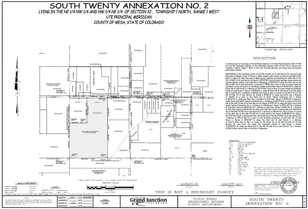
1 Public Hearing: February 20, 2019 CITY OF GRAND JUNCTION, COLORADO ORDINANCE NO. AN ORDINANCE ANNEXING TERRITORY TO THE CITY OF GRAND JUNCTION, COLORADO SOUTH TWENTY ANNEXATION APPROXIMATELY ACRES LOCATED AT 2335 H ROAD WHEREAS, on the 16 th day of January 2019, the City Council of the City of Grand Junction considered a petition for the annexation of the following described territory to the City of Grand Junction; and WHEREAS, a hearing on the petition was duly held after proper notice on the 20 th day of February 2019; and WHEREAS, the City Council determined that said territory was eligible for annexation and that no election was necessary to determine whether such territory should be annexed; NOW, THEREFORE, BE IT ORDAINED BY THE CITY COUNCIL OF THE CITY OF GRAND JUNCTION, COLORADO: That the property situate in Mesa County, Colorado, and described to wit: SOUTH TWENTY ANNEXATION NO. 1 A certain parcel of land lying in the Northeast Quarter of the Northwest Quarter (NE 1/4 NW 1/4 and the Northwest Quarter of the Northeast Quarter (NW 1/4 NE 1/4) of Section 32, Township 1 North, Range 1 West of the Ute Principal Meridian and being more particularly described as follows: COMMENCING at the Northeast corner of the NW 1/4 NE 1/4 of said Section 32 and assuming the North line of the NW 1/4 NE 1/4 of said Section 32 bears N W with all other bearings contained herein being relative thereto; thence from said Point of Commencement, S W, along the East line of the NW 1/4 NE 1/4 of said Section 32, a distance of 5.00 feet to a point on the South line of Apple Glen Annexation No. 2, Ordinance No as same is recorded in Book 4637, Page 687, Public Records of Mesa County, Colorado, also being the POINT OF BEGINNING; thence from said Point of Beginning, S W, along said East line, a distance of 2.00 feet; thence N W along a line 7.00 feet South of and parallel with the North line of the NW 1/4 NE 1/4 of said Section 32, a distance of feet; thence N E, a distance of 5.00 feet; thence N W along a line 2.00 feet South of and parallel with the North
2 line of the NW 1/4 NE 1/4 of said Section 32, a distance of feet, more or less, to a point on the East line of the NE 1/4 NW 1/4 of said Section 32; thence N W along a line 2.00 feet South of and parallel with the North line of the NE 1/4 NW 1/4 of said Section 32, a distance of feet, more or less, to a point on the Northerly projection of the East line of Parcel 1, Muller Simple Land Division, as same is recorded in Plat Book 17, Page 236, Public Records of Mesa County, Colorado; thence N W, along said Northerly projection, a distance of 2.00 feet to a point on the North line of the NE 1/4 NW 1/4 of said Section 32; thence S E, along said North line, a distance of feet, more or less, to a point being the Northeast corner of the NE 1/4 NW 1/4 of said Section 32; thence S E, along the North line of the NW 1/4 NE 1/4 of said Section 32, a distance of feet to a point on the West line of Apple Glen Annexation No. 3, Ordinance No. 4192, as same is recorded in Book 4637, Page 691, Public records of Mesa County, Colorado; thence S W, along said West line, a distance of 5.00 feet; thence S E along a line 5.00 feet South of and parallel with the North line of the NW 1/4 NE 1/4 of said Section 32, a distance of feet, more or less, to the Point of Beginning. CONTAINING 3,640 Square Feet or Acres, more or less, as described. TOGETHER WITH SOUTH TWENTY ANNEXATION NO. 2 A certain parcel of land lying in the Northeast Quarter of the Northwest Quarter (NE 1/4 NW 1/4 and the Northwest Quarter of the Northeast Quarter (NW 1/4 NE 1/4) of Section 32, Township 1 North, Range 1 West of the Ute Principal Meridian and being more particularly described as follows: BEGINNING at the Southwest corner of the NE 1/4 NW 1/4 of said Section 32, said point also being the Southwest corner of Parcel 1, Muller Simple Land Division, as same is recorded in Plat Book 17, Page 236, Public Records of Mesa County, Colorado and assuming the West line of the NE 1/4 NW 1/4 of said Section 32 bears N E and all other bearings shown hereon are relative thereto; thence from said Point of Beginning, N E along the West line of the NE 1/4 NW 1/4 of said Section 32, a distance of feet, more or less, to a point being the Southwest corner of Parcel 2 of said Muller Simple Land Division; thence S E, along the South line of said Parcel 2, a distance of feet, more or less, to a point being the Southeast corner of said Parcel 2; thence N E, along the East line of said Parcel 2 and the West line of said Parcel 1, a distance of feet, more or less, to a point on the North line of the NE 1/4 NW 1/4 of said Section 32; thence S E, along said North line, a distance of to a point on the West line of South Twenty Annexation No. 1; thence S E, along said West line, a distance of 2.00 feet; thence S E along the South line of said South Twenty Annexation No. 1, a distance of feet to a point on the East line of the NW 1/4 NE 1/4 of said Section 32; thence S E, along the South line of said South Twenty Annexation No. 1, a distance of feet; thence S W, a distance of 5.00 feet; thence N W, a distance of 2.00 feet; thence N
3 E, a distance of 3.00 feet; thence N W, along a line 4.00 feet South of and parallel with, the North line of the NW 1/4 NE 1/4 of said Section 32, a distance of feet, more or less, to a point on the East line of the NW 1/4 NE 1/4 of said Section 32; thence N W, along a line 4.00 feet South of and parallel with, the North line of the NE 1/4 NW 1/4 of said Section 32, a distance of feet to a point on the Northerly projection of the East line of said Parcel 1; thence S E, along the East line of said Parcel 1, a distance of feet, more or less, to a point on the South line of the NE 1/4 NW 1/4 of said Section 32, said point also being the Southeast corner of said Parcel 1; thence N W, along the South line of the NE 1/4 NW 1/4 of said Section 32, a distance of feet, more or less, to the Point of Beginning. CONTAINING 875,322 Square Feet or Acres, more or less, as described. be and is hereby annexed to the City of Grand Junction, Colorado. INTRODUCED on first reading on the 16 th day of January 2019 and ordered published in pamphlet form. ADOPTED on second reading the day of, 2019 and ordered published in pamphlet form. Attest: President of the Council City Clerk
4 Exhibit A Public Hearing: February 20, 2019
5 Exhibit B
ORDINANCE NO. 13,729
 ORDINANCE NO. 13,729 AN ORDINANCE to amend the Municipal Code of Des Moines, 1991, adopted by Ordinance No. 11,651, passed April 15, 1991, and amended by Ordinance No. 13,561, passed January 5, 1998 by
ORDINANCE NO WHEREAS, Marina District Development, LLC is the fee simple owner of the following described real estate, to wit:
 SPONSOR: Councilman Kalwinski PETITIONED BY: Marina District Development, LLC ORDINANCE NO. 9304 AN ORDINANCE VACATING A 859 FOOT PORTION OF 5 th AVENUE, MORE OR LESS, LYING BETWEEN 112 th STREET INDIANAPOLIS
PLAINFIELD TOWN COUNCIL RESOLUTION NO
 KOHL S PLAINFIELD TOWN COUNCIL RESOLUTION NO. 2016-33 RESOLUTION PRELIMINARILY DESIGNATING ECONOMIC REVITALIZATION AREA AND QUALIFYING CERTAIN REAL PROPERTY AND IMPROVEMENTS FOR TAX ABATEMENT - CORPORATION
ORDINANCE NO. 612, DESCRIPTION ATTACHED
 Insert BOARD OF TRUSTEES, TOWN or PAGOSA SPRINGS STATE OF COLORADO ORDINANCE NO. 612, AMENDING ORDINANCE NO. 561, ESTABLISHING THE TOWN OF PAGOSA SPRINGS SANITATION ENERAL IMPROVEMENT DISTRICT, TO CLARIFY
ORDINANCE NO. 14,723
 ORDINANCE NO. 14,723 AN ORDINANCE providing that general property taxes levied and collected each year on all property located within the Beaverdale Commercial Area Urban Renewal Area in the City of Des
ORDINANCE NO. 510 THEREFORE, BE IT ORDAINED BY THE GOVERNING BODY OF THE CITY OF BEL AIRE, KANSAS:
 (Published in The Ark Valley News on July, 2012.) ORDINANCE NO. 510 S-I-1 GILMORE & BELL, P.C. 07/11/2012 AN ORDINANCE CREATING A COMMUNITY IMPROVEMENT DISTRICT IN THE CITY OF BEL AIRE, KANSAS; AUTHORIZING
All that part of Lot 11, Sunset Hill, a subdivision in the City of Overland Park, Johnson County, Kansas, more particularly described as follows:
 NOTICE OF PUBLIC HEARING CITY PLANNING COMMISSION CITY OF OVERLAND PARK, KANSAS Notice is hereby given that the City Planning Commission of Overland Park, Kansas, will hold a public hearing Monday, February
SPECIAL USE PERMIT - SUP Blue Valley Parkway
 NOTICE OF PUBLIC HEARING CITY PLANNING COMMISSION CITY OF OVERLAND PARK, KANSAS Notice is hereby given that the City Planning Commission of Overland Park, Kansas, will hold a public hearing Monday, April
ORDI NANC E NO
 ORDI NANC E NO. 13622 AN ORDINANCE to amend the Official Zoning Map of the City of Des Moines, Iowa, set forth in Section 2A-5 of the Municipal Code of the City of Des Moines, 1991, by rezoning and changing
RESOLUTION GRANTING A TWO YEAR EXTENSION TO SURE SANITATION SERVICE FOR RESIDENTIAL GARBAGE COLLECTION IN ORANGE counn
 RESOLUTION GRANTING A TWO YEAR EXTENSION TO SURE SANITATION SERVICE FOR RESIDENTIAL GARBAGE COLLECTION IN ORANGE counn WHEREAS, SURE SANITATION SERVICE is currently a licensed franchisee b~ ORANGE COUNTY
Parker & Lincoln Development, LLC
 Parker & Lincoln Development, LLC 4643 S. Ulster Street, Suite 240 Denver, Colorado 80237 (303) 799-4030 VIA FEDEX OVERNIGHT DELIVERY December 19, 2017 Town of Parker Attn: Ryan McGee 20120 E. Mainstreet
ORDINANCE NO WHEREAS, the current owner of the Fontaine Fox house and lands west of A-1-A wishes to amend Ordinance No
 ORDINANCE NO. 43-11 AN ORDINANCE OF THE CITY COMMISSION OF THE CITY OF DELRAY BEACH, FLORIDA, AMENDING ORDINANCE NO. 70-89 THAT PROVIDED FOR THE HISTORIC DESIGNATION OF THE FONTAINE FOX HOUSE AND PROPERTY;
PROPERTY OWNER PETITION FOR CONCURRENT DETACHMENT AND ANNEXATION
 PROPERTY OWNER PETITION FOR CONCURRENT DETACHMENT ANNEXATION IN THE MATTER OF THE PETITION BY ALL OF THE PROPERTY OWNERS FOR THE DETACHMENT OF CERTAIN L FROM THE CITY OF NOWTHEN, MINNESOTA CONCURRENT ANNEXATION
SPECIAL USE PERMIT - SUP West 159th Street. SBMS cell site 4459, Lot 1, a subdivision in Overland Park, Johnson County, Kansas.
 NOTICE OF PUBLIC HEARING CITY PLANNING COMMISSION CITY OF OVERLAND PARK, KANSAS Notice is hereby given that the City Planning Commission of Overland Park, Kansas, will hold a public hearing Monday, May
MINUTES FROM A REGULAR MEETING OF THE COUNCIL OF MUSCLE SHOALS, ALABAMA, HELD July 2, 2018
 MINUTES FROM A REGULAR MEETING OF THE COUNCIL OF MUSCLE SHOALS, ALABAMA, HELD July 2, 2018 The City Council of Muscle Shoals, Alabama met at the Muscle Shoals City Hall nd auditorium in said City at 6:00
Notice of Intent of Waiver with Respect to Land; Fort Wayne International Airport, Fort Wayne, IN. AGENCY: Federal Aviation Administration (FAA), DOT.
, DOT.") This document is scheduled to be published in the Federal Register on 03/23/2018 and available online at https://federalregister.gov/d/2018-05888, and on FDsys.gov [4910-13] DEPARTMENT OF TRANSPORTATION
This document is scheduled to be published in the Federal Register on 03/23/2018 and available online at https://federalregister.gov/d/2018-05888, and on FDsys.gov [4910-13] DEPARTMENT OF TRANSPORTATION
MINUTES FROM A REGULAR MEETING OF THE COUNCIL OF MUSCLE SHOALS, ALABAMA, HELD July 17, 2017
 MINUTES FROM A REGULAR MEETING OF THE COUNCIL OF MUSCLE SHOALS, ALABAMA, HELD July 17, 2017 The City Council of Muscle Shoals, Alabama met at the Muscle Shoals City Hall th auditorium in said City at 6:30
Public Notice for Waiver of Aeronautical Land-Use Assurance. AGENCY: Federal Aviation Administration (FAA), DOT
, DOT") This document is scheduled to be published in the Federal Register on 09/06/2017 and available online at https://federalregister.gov/d/2017-18845, and on FDsys.gov [4910-13] DEPARTMENT OF TRANSPORTATION
This document is scheduled to be published in the Federal Register on 09/06/2017 and available online at https://federalregister.gov/d/2017-18845, and on FDsys.gov [4910-13] DEPARTMENT OF TRANSPORTATION
IN THE CHANCERY COURT OF LAMAR COUNTY, MISSISSIPPI CIVIL ACTION NO.: CITY OF HATTIESBURG, MISSISSIPPI
 IN THE CHANCERY COURT OF LAMAR COUNTY, MISSISSIPPI IN THE MATTER OF THE INCORPORATION OF THE CITY OF BELLEVUE, MISSISSIPPI, BELLEVUE INCORPORATORS VS. CITY OF HATTIESBURG, MISSISSIPPI PETITIONERS CIVIL
CITY OF PALMDALE. REPORT to the Mayor and Members of the City Council from the City Manager
 CITY OF PALMDALE REPORT to the Mayor and Members of the City Council from the City Manager DATE: February 4, 2015 SUBJECT: Zone Verification 14-017; 155 acres Located on the North Side of Avenue P at 30th
 SURVEYOR'S CERTIFICATE RIVERFRONT MASTER PLANNED MIXED USE DISTRICT PHASE 3 SUBDIVISION PLAT I, SATTAR N. TABRIZ, DO HEREBY CERTIFY THAT I AM A PROFESSIONAL LAND SURVEYOR LICENSED TO PRACTICE IN THE STATE
PETITION TO CONTINUE THE DOWNTOWN DES MOINES SELF-SUPPORTED MUNICIPAL IMPROVEMENT DISTRICT PURSUANT TO CHAPTER 386, CODE OF IOWA
 PETITION TO CONTINUE THE DOWNTOWN DES MOINES SELF-SUPPORTED MUNICIPAL IMPROVEMENT DISTRICT PURSUANT TO CHAPTER 386, CODE OF IOWA We, the undersigned, being at least 25 per cent of all owners of property
Great Development Opportunity
 Great Development Opportunity NW Corner I-94 / 66th St. 3238 66th St. NE $2,600,000 - Approx. 40 Acres Proposed Interchange 80th St 66th St. 66th St. to Lincoln Future Residential New Multi-Family Development
CenturyTel of Northern Michigan, Inc. d/b/a CenturyLink Original Sheet No. 1 M.P.S.C. No. 1 (R)
") CenturyTel of Northern Michigan, Inc. d/b/a CenturyLink Original Sheet No. 1 CenturyTel of Northern Michigan, Inc. d/b/a CenturyLink Applying to the Local Calling Scope and Exchange Boundaries of this
CenturyTel of Northern Michigan, Inc. d/b/a CenturyLink Original Sheet No. 1 CenturyTel of Northern Michigan, Inc. d/b/a CenturyLink Applying to the Local Calling Scope and Exchange Boundaries of this
R RESOLUTION 53RD AVENUE WEST (PROJECT NO. 3168)
") y/^oo RECORDED.' RESOLUTION R-00-23 PAGE NO. -JZoJ hwat NU.. v I..I...Y. MtNUTE BOOK NO.^J A RESOLUTION AUTHORIZING USE OF "QUICK TAKING- CONDEMNATION PROCEEDINGS FOR THE PUBLIC USE AND PUBLIC PURPOSE
y/^oo RECORDED.' RESOLUTION R-00-23 PAGE NO. -JZoJ hwat NU.. v I..I...Y. MtNUTE BOOK NO.^J A RESOLUTION AUTHORIZING USE OF "QUICK TAKING- CONDEMNATION PROCEEDINGS FOR THE PUBLIC USE AND PUBLIC PURPOSE
The following Ordinance was submitted for introduction by Brent Callais in regular session convened on March 8, 2005: PROPOSED ORDINANCE
 The following Ordinance was submitted for introduction by Brent Callais in regular session convened on March 8, 2005: PROPOSED ORDINANCE The following Ordinance, having been previously introduced and published,
M I N U T E S OKLAHOMA COUNTY PLANNING COMMISSION
 M I N U T E S OKLAHOMA COUNTY PLANNING COMMISSION March 18, 2004 1:30 p.m. The meeting of the Oklahoma County Planning Commission convened and was called to order by Mr. Will Jones, Vice-Chairperson, at
O R D I N A N C E NO AN ORDINANCE, amending Section Two of Ordinance No. 1864, adopted April 3, 1969 and revising the boundaries of
 O R D I N A N C E NO. 2032 AN ORDINANCE, amending Section Two of Ordinance No. 1864, adopted April 3, 1969 and revising the boundaries of Subdistrict No. 268 (Lin-Ferry - Tesson Ferry) of The Metropolitan
August 30, Adam Sayre City of Verona Planning & Development 111 Lincoln Street Verona, WI 53593
 August 30, 2018 Adam Sayre City of Verona Planning & Development 111 Lincoln Street Verona, WI 53593 RE: Second Addition to Cathedral Point City of Verona Future Public Works Facility Annexation Description
The Alberta Gazette. Part I. Vol. 100 Edmonton, Thursday, April 15, 2004 No. 7 RESIGNATIONS AND RETIREMENTS. (Justice of the Peace Act)
") The Alberta Gazette Part I Vol. 100 Edmonton, Thursday, April 15, 2004 No. 7 RESIGNATIONS AND RETIREMENTS (Justice of the Peace Act) Resignation of Justice of the Peace February 27, 2004 Taylor, Karen
The Alberta Gazette Part I Vol. 100 Edmonton, Thursday, April 15, 2004 No. 7 RESIGNATIONS AND RETIREMENTS (Justice of the Peace Act) Resignation of Justice of the Peace February 27, 2004 Taylor, Karen
CITY OF SNOHOMISH Snohomish, Washington ORDINANCE 2019 AN ORDINANCE OF THE CITY OF SNOHOMISH, WASHINGTON ESTABLISHING A NEW LAND USE DESIGNATION MAP.
 OF SNOHOMISH Snohomish, Washington ORDINANCE 2019 AN ORDINANCE OF THE OF SNOHOMISH, WASHINGTON EABLISHING A NEW LAND USE DESIGNATION MAP. WHEREAS, the City Council considers long-range planning as embodied
GREENSBORO-JAMESTOWN JOINT ANNEXATION AGREEMENT
 NORTH CAROLINA GUILFORD COUNTY GREENSBORO-JAMESTOWN JOINT ANNEXATION AGREEMENT THIS AGREEMENT, made and entered into this the day of, 2011 by and between the City of Greensboro and the Town of Jamestown.
Fee:$O.OO P DAWSON CTY, MT Rec/Filed 1
 462708 Fee:$O.OO P DAWSON CTY, MT Rec/Filed 1 Shirley Kreiman, Clk & Rcdr By..; I ~::::!o:::!::::~~!..!:!~~~~ RETURN TO: FILED RESOLUTION 2017-33 RESOLUTION OF INTENTION TO CREATE RURAL SPECIAL IMPROVEMENT
City of Grand Island Tuesday, July 11, 2017 Council Session
 City of Grand Island Tuesday, July 11, 2017 Council Session Item G-4 #2017-193 - Approving Final Plat and Subdivision Agreement for Hope Valley Subdivision Staff Contact: Chad Nabity Grand Island Council
Boone County Commission Minutes 27 May Roger B. Wilson Boone County Government Center Commission Chambers
 TERM OF COMMISSION: PLACE OF MEETING: PRESENT WERE: May Session of the May Adjourned Term Roger B. Wilson Boone County Government Center Commission Chambers Presiding Commissioner Keith Schnarre District
DanielCompanies.com. 80th St. 66th St. to Lincoln. 66th St. 43rd Ave. Century Ave. Exit 161. Centennial Rd.
 Century Ave. Proposed Interchange 80th St 43rd Ave. 66th St. Future Residential 66th St. to Lincoln New Multi-Family Development Centennial Rd. Exit 161 Great Future Opportunity for Travel Center & Other
BE IT ORDAINED by the Mayor and the City Council of the City of Papillion as follows:
 ORDINANCE NO. 1798 AN ORDINANCE TO AMEND CHAPTER 24, SECTION 1 DELINEATING THE VOTING BOUNDARY WARDS FOR THE CITY OF PAPILLION; TO REPEAL THE EXISTING CHAPTER 24, SECTION 1; AND TO PROVIDE FOR AN EFFECTIVE
Brad Wetstone. Girish Balachandran General Manager
 AGENDA ITEM NO: 3.F.1 MEETING DATE: 08/16/2010 ADMINISTRATIVE REPORT NO.: 2011-09 To: Honorable Public Utilities Board Submitted by: /s/ Alan Hanger Sr. Energy Resources Analyst From: Brad Wetstone Sr.
DO ORDAIN AS FOLLOWS:
 -~- ~~-- - -----,, ----- 1 i ; ORDINANCE NO. ~ -' 1 1 1 IS 1 1 1 1 0 1,.-.. ~ -t '' An Ordinance of the City of Los Angeles finding that the public interest, convenience and necessity require the acquisition,
ANCHORAGE, ALASKA AO NO
 Submitted by: Assembly Member Demboski Prepared by: Assembly Counsel For reading: January 9, 2018 ANCHORAGE, ALASKA AO NO. 2018 3 1 2 3 4 5 6 7 8 9 10 11 12 13 14 15 16 17 18 19 20 21 22 23 24 25 26 27
COUNCIL OF THE TOWN OF LA PLATA Ordinance No a
 COUNCL OF THE TOWN OF LA PLATA Ordinance No. 12-21a ntroduced By: Mayor Roy G. Hale Date ntroduced: November 27 2012 Town Council Public Hearing: Amendments Adopted: N/A N/A Date Adopted: December 18 2012
FILE NO. ANMICALGIC-1
 MUNICIPAL GOVERNMENT BOARD FILE NO. ANMICALGIC-1 IN TEE MATTER OF THE "Municipal Government Act" AND IN THE MATTER OF an application by the City of Calgary, in the Province of Alberta, to annex certain
ORDER CALLING PUBLIC HEARING TOBE HELD ON MARCH 2, 2016
 A regular meeting of the Town Board of the Town of New Windsor, in the County of Orange, New York, was held at the Town Hall, in said Town, on the 3rd day of February, 2016. PRESENT: George A. Green, Supervisor
ADMINISTRATIVE ORDER NUMBER SC-16 RESPECTING CLOSURE OF A PORTION OF FOREST HILLS PARKWAY AND HIGHWAY #7 AND PANAVISTA DRIVE
 HALIFAX REGIONAL MUNICIPALITY ADMINISTRATIVE ORDER NUMBER SC-16 RESPECTING CLOSURE OF A PORTION OF FOREST HILLS PARKWAY AND HIGHWAY #7 AND PANAVISTA DRIVE BE IT RESOLVED AS AN ADMINISTRATIVE ORDER of Council
Bill 215 (Private) An Act to amend the charter of the City of Laval
 An Act to amend the charter of the City of Laval") SECOND SESSION THIRTY-SIXTH LEGISLATURE Bill 215 (Private) An Act to amend the charter of the City of Laval Introduced 8 May 2002 Passage in principle 14 June 2002 Passage 14 June 2002 Assented to 14 June
SECOND SESSION THIRTY-SIXTH LEGISLATURE Bill 215 (Private) An Act to amend the charter of the City of Laval Introduced 8 May 2002 Passage in principle 14 June 2002 Passage 14 June 2002 Assented to 14 June
CLIENT: CITY OF SUN PRAIRIE 300 EAST MAIN STREET SUN PRAIRIE, WI OWNER: MART ENTERPRISES, LLC SOUTH WILDWOOD STREET TOWN BURKE LOT 1
 SOUTH DRIVE SOUTH DRIVE maxwell shot after standing it up straight texted coordinates XXXXXXXXXX XXX PROJECT NO. DRAWN BY: SURVEYOR: FILE NO. SHEET NO. 00036147 B. TISDALE B. TISDALE 00036147 1 1 ARCHITECTURE
Section XII Miscellaneous
 PROPOSAL CONTENT Each responding consulting firm shall provide (4) copies of their proposal giving detailed information on the following: 1. Firm history, location, capabilities, etc. 2. USGA Form 254
Property Description and Persons Having an Interest Therein
 Cause of Action No. Property Description and Persons Having an Interest Therein 1 Beginning 600 feet North of the Southwest corner of the Southeast Quarter of the Northeast Quarter (SE4 NE4) Section Eleven
From: Clare Marley, AlCP ( /)7L^
7L^") Planning Department 1500 Hwy 2, Suite 208 Sandpoint, ID 83864 (208) 265-1458 December 16, 2015 Memorandum "Pi To: Board of County Commissioners From: Clare Marley, AlCP ( /)7L^ Re: Resolution vacating
Planning Department 1500 Hwy 2, Suite 208 Sandpoint, ID 83864 (208) 265-1458 December 16, 2015 Memorandum "Pi To: Board of County Commissioners From: Clare Marley, AlCP ( /)7L^ Re: Resolution vacating
Approving War Secretary Recommendation to Reserve Seven Tracts of Land in Philippine Islands for Military Purposes
 Approving War Secretary Recommendation to Reserve Seven Tracts of Land in Philippine Islands for Military Purposes The following is the description from the Department of War's General Order No. 77 of
1 The Cadastral Mapping Fee Order (AR 94/2000) is amended by this Regulation.
 is amended by this Regulation.") Alberta Regulation 21/2005 Surveys Act CADASTRAL MAPPING FEE AMENDMENT ORDER Filed: March 2, 2005 For information only: Made by the Minister of Sustainable Resource Development (M.O. 03/2005) on February
Alberta Regulation 21/2005 Surveys Act CADASTRAL MAPPING FEE AMENDMENT ORDER Filed: March 2, 2005 For information only: Made by the Minister of Sustainable Resource Development (M.O. 03/2005) on February
MUSCATINE COUNTY BOARD OF SUPERVISORS
 MUSCATINE COUNTY BOARD OF SUPERVISORS Robert Howard, District One Matt Bonebrake, District Two Scott Sauer, District Three Nathan Mather, District Four Jeff Sorensen, District Five AGENDA 9:00 a.m. 1.
The north half of Section 18, Township 37 North, Range 6 East, Second Principal Meridian, Jefferson Township, Elkhart County, Indiana; also,
 The north half of Section 18, Township 37 North, Range 6 East, Second Principal Meridian, Jefferson Township, Elkhart County, Indiana; also, The east half of Sections 21, 28, and 33, Township 37 North,
RESOLUTION NO. R EXHIBIT A ACQUISITIONS
 RESOLUTION NO. R2010-04 EXHIBIT A ACQUISITIONS Contract Segment: D235 Brooklyn Station Page 1 R/W No. Tax Parcel No. Owner / Contact NL 426 114200 0905 David A. Koh & Christopher J. Koh, Co-ees of ABCD
The Alberta Gazette RESIGNATIONS AND RETIREMENTS ORDERS IN COUNCIL PART 1. Vol. 96 EDMONTON, THURSDAY, JUNE 15, 2000 No.11 JUSTICE OF THE PEACE ACT
 The Alberta Gazette PART 1 Vol. 96 EDMONTON, THURSDAY, JUNE 15, 2000 No.11 RESIGNATIONS AND RETIREMENTS JUSTICE OF THE PEACE ACT Resignation of Justice of the Peace May 15, 2000 Sailer, Rhonda May of Grande
CITY OF KASOTA Kasota, MN 56050
 CITY OF KASOTA Kasota, MN 56050 June 2, 1988 TO THE MINNESOTA MUNICIPAL BOARD 165 Metro Square Building St Paul, Minnesota 55101 IN THE MATTER OF THE JOINT RESOLUTION OF THE TOWN OF KASOTA AND THE CITY
Property Address: 4844 LUM RD ATTICA MI Owner: LAPEER COUNTY TREASURER Taxpayer: DUNCAN EDWARD
 08/16/2017 FORECLOSURE LIST FOR LAPEER COUNTY 11:15 AM For 2017 Foreclosures of 2014 and prior taxes BY: WMM POPULATION: BLOCK, INDEX: FORCL. YEAR/PARCEL # Interest Computed As Of Foreclosure Date TAXNTEREST/FEES
ORDINANCE NO WHEREAS, Section NMSA 1978 requires that the Town Council redistrict the Town s
 ORDINANCE NO. 1186 AN ORDINANCE AMENDING MUNICIPAL CODE CHAPTER 2, ARTICLE II (ELECTIONS), 2 50 (b)(1-4)) REORGANIZING EXISTING TOWN COUNCIL DISTRICTS OF THE TOWN OF SILVER CITY Sponsor: Mayor James R.
Public Notice for Waiver of Aeronautical Land-Use Assurance. AGENCY: Federal Aviation Administration (FAA), DOT
, DOT") This document is scheduled to be published in the Federal Register on 07/18/2016 and available online at http://federalregister.gov/a/2016-16937, and on FDsys.gov [4910-13] DEPARTMENT OF TRANSPORTATION
This document is scheduled to be published in the Federal Register on 07/18/2016 and available online at http://federalregister.gov/a/2016-16937, and on FDsys.gov [4910-13] DEPARTMENT OF TRANSPORTATION
OBSOLETE PROPERTY REHABILITATION CERTIFICATE FOR PROPERTY AT 107 S. WASHINGTON AVENUE
 RESOLUTION R-4 OBSOLETE PROPERTY REHABILITATION CERTIFICATE FOR PROPERTY AT 107 S. WASHINGTON AVENUE Council Member moved, seconded by Council Member to adopt the following resolution: WHEREAS, under P.A.
BY-LAW NO TO DIVIDE THE TOWN S TERRITORY INTO SIX ELECTORAL DISTRICTS
 BY-LAW NO. TO DIVIDE THE TOWN S TERRITORY INTO SIX ELECTORAL DISTRICTS ADOPTION PROCEDURE SUMMARY NOTICE OF MOTION: MARCH 21, 2016 ADOPTION OF BY-LAW: MAY 16, 2016 COMING INTO EFFECT: OCTOBER 31, 2016
z-*."$ 04 : 24 : 4 0 ~ ~ 07/25/86 a"." Ean, RESOLUTION BOARD OF COUNTY COMMISSIONERS OF ORANGE COUNTY, FLORIDA BY: Tom Dorman, Chairman.
 APPROVED BY THE BOARD OF COUNTY COMMISSIONERS AT THEIR MEETING JUL 2 1 1986 RESOLUTION WHEREAS, the board of County Commissioners of Orange County at its board meeting on July 21st 1986, accepted the revised
RICH COUNTY MAY TAX SALE LISTING
 RICH COUNTY MAY TAX SALE LISTING Notice is hereby given that on the 17th day of May, 2017, at 10:00 am in the Courtroom of the County Courthouse in Rich County, Utah; I will offer for sale at public auction
THE ALBERTA GAZETTE, SEPTEMBER
 VILLAGE OF CEREAL Order No. 16915 IN THE MATTER OF THE "Municipal Government Act": File No. 241(A)3 AND IN THE MATTER OF an application by the Council of the Village of Cereal, in the Province of Alberta,
ALTA/ACSM LAND TITLE SURVEY Parts of Augusta Heights, First Section (Plat Book 20, Page 5), Augusta Heights, Second Section (Plat Book 19, Page 25),
, Augusta Heights, Second Section (Plat Book 19, Page 25),") ALTA/ACSM LAND TITLE SURVEY Parts of Augusta Heights, First Section (Plat Book 20, Page 5), Augusta Heights, Second Section (Plat Book 19, Page 25), and Augusta Park, 3rd Section (Plat Book 24, Page 132)
ALTA/ACSM LAND TITLE SURVEY Parts of Augusta Heights, First Section (Plat Book 20, Page 5), Augusta Heights, Second Section (Plat Book 19, Page 25), and Augusta Park, 3rd Section (Plat Book 24, Page 132)
A RESOLUTION NOW, THEREFORE, BE IT RESOLVED BY THE CITY COUNCIL OF THE CITY OF EL PASO THAT:
 A RESOLUTION EXPRESSING THE CITY OF EL PASO S INTENT TO CREATE TRANSPORTATION REINVESTMENT ZONE NO. 1 TO FINANCE TRANSPORTATION PROJECTS IN SUPPORT OF THE COMPREHENSIVE MOBILITY PLAN FOR EL PASO; SETTING
PUBLIC HEARING & COUNCIL MEETING MINUTES February 11 th, 2019
 PUBLIC HEARING & COUNCIL MEETING MINUTES February 11 th, 2019 The Common Council of the City of Kokomo, Indiana met Monday, February 11 th, 2019 at 6:00 P.M. in the Council Chambers for the purpose of
DRAFT GENERAL IMPLEMENTATION PLAN AND SPECIFIC IMPLEMENTATION PLAN MIDDLETON MUNICIPAL AIRPORT MOREY FIELD. Revised 12/12/03
 DRAFT GENERAL IMPLEMENTATION PLAN AND SPECIFIC IMPLEMENTATION PLAN MIDDLETON MUNICIPAL AIRPORT MOREY FIELD Revised 12/12/03 As recommended for approval by the Plan Commission General Project Description
Iron Range Brownfield Assessment Coalition Site Eligibility and Property Ownership Determination Community: City of Eveleth
 Iron Range Brownfield Assessment Coalition Site Eligibility and Property Ownership Determination Community: City of Eveleth Site: City Snow Dump Date: November 20, 2012 A. Basic Site Information: Name:
Agenda Item # Page # CHAIR AND MEMBERS BOARD OF CONTROL MEETING ON WEDNESDAY, AUGUST 26,2009. PAT McNALLY. P.ENG. ii
 Ii r--... TO: CHAIR AND MEMBERS BOARD OF CONTROL MEETING ON WEDNESDAY, AUGUST 26,2009 I I PAT McNALLY. P.ENG. ii rrwm; GENERAL MANAGER OF ENVIRONMENTAL AND ENGINEERING SERVICES AND CITY ENGINEER SUBJECT
The Alberta Gazette PROCLAMATION PART 1. Vol. 96 EDMONTON, SATURDAY, DECEMBER 30, 2000 No. 24 [GREAT SEAL] CANADA
![The Alberta Gazette PROCLAMATION PART 1. Vol. 96 EDMONTON, SATURDAY, DECEMBER 30, 2000 No. 24 [GREAT SEAL] CANADA](/thumbs/93/112001396.jpg "The Alberta Gazette PROCLAMATION PART 1. Vol. 96 EDMONTON, SATURDAY, DECEMBER 30, 2000 No. 24 [GREAT SEAL] CANADA") The Alberta Gazette PART 1 Vol. 96 EDMONTON, SATURDAY, DECEMBER 30, 2000 No. 24 [GREAT SEAL] CANADA PROVINCE OF ALBERTA PROCLAMATION Lois E. Hole, Lieutenant Governor. ELIZABETH THE SECOND, by the Grace
The Alberta Gazette PART 1 Vol. 96 EDMONTON, SATURDAY, DECEMBER 30, 2000 No. 24 [GREAT SEAL] CANADA PROVINCE OF ALBERTA PROCLAMATION Lois E. Hole, Lieutenant Governor. ELIZABETH THE SECOND, by the Grace
Topographic Maps. Background Sheet
 Topographic Maps History: Background heet The Articles of Confederation (1777) was ratified when western lands were yielded to the Federal Government. This yielding of land gave the Federal Government
City of North Liberty
 City of North Liberty City Council Agenda Special Session August 3, 11 AGENDA North Liberty City Council August 3, 11 Special Session :3 p.m. Council Chambers 1. Call to order.. Roll call. 3. Approval
THE CORPORATION OF THE CITY OF BRAMPTON BY-LAW
 THE CORPORATION OF THE CITY OF BRAMPTON BY-LAW Number... ', _6.;.;1;;.,-...,;;8..;;;3 --,.. To designate the Od1um-Morelli Home as a property of historical and archi tec'tura1 value and in~ere_st WlIEREASsection
FOR SALE OR LEASE. St. Croix Meadows Redevelopment LOTS FOR SALE. Hudson, WI
 St. Croix Meadows Redevelopment EXIT RAMP EXISTING OVERPASS VACATE R.O.W. CARMICHAEL RD ON RAMP HIGH-TECH/FLEX SPACE MEDICAL OFFICE - 20K SF EACH RETAIL / ENTERTAINMENT 24-46K SF FULL ACCESS CORPORATE
O.C , 8 February 2012
 490 GAZETTE OFFICIELLE DU QUÉBEC, February 22, 2012, Vol. 144, No. 8 Part 2 PRESERVATIVE AC Must contain HCI in sufficient concentration to acidify sample to ph < 2 AN Must contain HNO 3 in sufficient
ORDINANCE NO. 15,670
 ORDINANCE NO. 15,670 AN ORDINANCE to amend the Municipal Code of the City of Des Moines, Iowa, 2000, adopted by Ordinance No. 13,827, passed June 5, 2000, as heretofore amended, by amending Sections 114-361.01,
Preliminary Plat Extension Agreement (Cortona)
") Preliminary Plat Extension Agreement (Cortona) This Preliminary Plat Extension Agreement (Cortona) ( Agreement ) by and between MARICOPA 240, L.L.C., an Arizona limited liability company and Desert Sunrise,
Preliminary Plat Extension Agreement (Cortona) This Preliminary Plat Extension Agreement (Cortona) ( Agreement ) by and between MARICOPA 240, L.L.C., an Arizona limited liability company and Desert Sunrise,
CASE NO. 2019CW10 (REF NO. 12CW118).
.") IN THE DISTRICT COURT IN AND FOR WATER DIVISION NO. 4 STATE OF COLORADO TO: ALL PERSONS INTERESTED IN WATER APPLICATIONS IN SAID WATER DIVISION NO. 4 Pursuant to C.R.S. 37-92-302, as amended, you are notified
IN THE DISTRICT COURT IN AND FOR WATER DIVISION NO. 4 STATE OF COLORADO TO: ALL PERSONS INTERESTED IN WATER APPLICATIONS IN SAID WATER DIVISION NO. 4 Pursuant to C.R.S. 37-92-302, as amended, you are notified
the zoning sought for the tract to be rezoned is I1/FF/FW, Light Industrial District with Floodway Fringe and Floodway Overlay Districts; and
 Bill No. Requested by: Wayne Anthony Sponsored by: John White Ordinance No. AN ORDINANCE AMENDING THE ZONING DISTRICT MAP OF THE COUNTY OF ST. CHARLES, MISSOURI, BY REZONING LAND FROM A/FF/FW, AGRICULTURAL
MUNICIPAL GOVERNMENT ACT O.C. 416/96
 c THE ALBERTA GAZETTE, PART I, SEPTEMBER 30, 1996 MUNICIPAL GOVERNMENT ACT O.C. 416/96 Approved and Ordered, H.A. "Bud" Olson, Lieutenant Governor. Edmonton, September 3, 1996 The Lieutenant Governor in
CITY OF OCEAN SHORES, WASHINGTON ORDINANCE NO. 940
 CITY OF OCEAN SHORES, WASHINGTON ORDINANCE NO. 940 AN ORDINANCE OF THE CITY COUNCIL OF THE CITY OF OCEAN SHORES, WASHINGTON, AMENDING OCEAN SHORES MUNICIPAL CODE TITLE 15 BUILDINGS AND CONSTRUCTION, CHAPTER
H 7766 AS AMENDED S T A T E O F R H O D E I S L A N D
 ======= LC0 ======= 0 -- H AS AMENDED S T A T E O F R H O D E I S L A N D IN GENERAL ASSEMBLY JANUARY SESSION, A.D. 0 A N A C T RELATING TO STATE AFFAIRS AND GOVERNMENT -- SOVEREIGNTY AND JURISDICTION
O R D I N A N C E NO AN ORDINANCE, transferring Two Million Three Hundred. Ninety-Four Thousand Three Hundred Twenty Dollars ($2,394,320.
 O R D I N A N C E NO. 6486 AN ORDINANCE, transferring Two Million Three Hundred Ninety-Four Thousand Three Hundred Twenty Dollars ($2,394,320.00) as a loan from the General Fund of the District to the
min Il II II HI HI 1 III
 ÉTORONTO Archives min Il II II HI HI 1 III TORONTO BY-LAW NUMBER 1990-0280 BOX NUMBER P020009 Produced according to archival standards for the creation of electronic records by the City of Toronto Archives,
WHEREAS, annexation would be in the best interests of the subject area,
 Joint Resolution of the City of Mountain Lake and Town of Mountain Lake Pursuant to Minnesota Statutes Section 414.0325, Subdivision 1, Designating Certain Unincorporated Land as in Need of Orderly Annexation,
 Page 1 of 10 ARTICLE XXXIX. HOMESTEAD GENERAL AVIATION AIRPORT ZONING* *Editor's note: Article XXXIX, 33-372--33-387, is derived from Ord. No. 69-38, 1--16, enacted July 9, 1969. Section 17 of said ordinance
Crown Lands and Property Agency. Name Client # LAST (Please Print) FIRST MIDDLE (no initials) Mailing Address. Postal Code
 FIRST MIDDLE (no initials) Mailing Address. Postal Code") Manitoba Conservation and Water Stewardship Application for Permit/Lease/Purchase/Easement/Exchange/Licence of Occupation (under The Crown Lands Act c.c340) Please check one ( ) Permit Lease Purchase Easement
Manitoba Conservation and Water Stewardship Application for Permit/Lease/Purchase/Easement/Exchange/Licence of Occupation (under The Crown Lands Act c.c340) Please check one ( ) Permit Lease Purchase Easement
* ** Stanwood. Camano. School District. "k'kk
 Stanwood * ** "k'kk Camano School District TO FROM SUBJECT DATE TYPE BOARD OF DIRECTORS DR. JEAN SHUMATE, SUPERINTENDENT GARY PLATT, EXECUTIVE DIRECTOR - BUSINESS SERVICES DIRECTOR DISTRICT REBALANCING
Bill 275 (Private) An Act respecting certain immovables of the cadastre of the parish of Saint-Louisde-Terrebonne
 An Act respecting certain immovables of the cadastre of the parish of Saint-Louisde-Terrebonne") NATIONAL ASSEMBLY SECOND SESSION THIRTY-FIFTH LEGISLATURE Bill 275 (Private) An Act respecting certain immovables of the cadastre of the parish of Saint-Louisde-Terrebonne Introduced 11 June 1998 Passage
NATIONAL ASSEMBLY SECOND SESSION THIRTY-FIFTH LEGISLATURE Bill 275 (Private) An Act respecting certain immovables of the cadastre of the parish of Saint-Louisde-Terrebonne Introduced 11 June 1998 Passage
SWISHER COUNTY SALES FOR AUGUST 7, 2012 SCHEDULED FOR 10:00 A. M. Tax Sales Information*
 SWISHER COUNTY SALES FOR AUGUST 7, 2012 SCHEDULED FOR 10:00 A. M. Tax Sales Information* 1) Tax foreclosure sales are conducted by the Sheriff or a Constable of the county where the property is located.
City of Port St. Lucie Planning and Zoning Department ALL DATES ARE TENTATIVE AND SUBJECT TO CHANGE SCHEDULES FOR 2018
 Planning and Zoning Department ALL DATES ARE TENTATIVE AND SUBJECT TO CHANGE SCHEDULES FOR NOTE: DELIVERY DEADLINE ON ALL SUBMITTALS, INCLUDING ONLINE, IS 12:00 NOON ALL DRAWINGS SUBMITTED MUST BE BLACKLINE,
MICHIGAN DEPARTMENT OF NATURAL RESOURCES FOREST RESOURCES DIVISION COMMERCIAL FOREST PROGRAM - HUNTER LIST
 MICHIGAN DEPARTMENT OF NATURAL RESOURCES FOREST RESOURCES DIVISION COMMERCIAL FOREST PROGRAM - HUNTER LIST Lands listed as of 03/18/2019 OTSEGO County Location: CHARLTON-30N-01W-05 154 Acres. Part 512:
REGIONAL WATER QUALITY MANAGEMENT PLAN WALWORTH COUNTY METROPOLITAN SEWERAGE DISTRICT / ELKHORN SANITARY SEWER SERVICE AREA
 AMENDMENT TO THE REGIONAL WATER QUALITY MANAGEMENT PLAN WALWORTH COUNTY METROPOLITAN SEWERAGE DISTRICT / ELKHORN SANITARY SEWER SERVICE AREA AS ADOPTED BY THE SOUTHEASTERN WISCONSIN REGIONAL PLANNING COMMISSION
CORPORATION OF THE TOWNSHIP OF BONNECHERE VALLEY BY-LAW # Being a By-Law to provide for Cash in Lieu of Required Parking Spaces
 CORPORATION OF THE TOWNSHIP OF BONNECHERE VALLEY BY-LAW #2007-35 Being a By-Law to provide for Cash in Lieu of Required Parking Spaces WHEREAS, Section 40 of The Planning Act, R.S.O. 1990, c.p.13, makes
Here Insert Name and Title of the Officer personally appeared Name(s) of Signer(s)
 of Signer(s)") CALIFORNIA ALL-PURPOSE ACKNOWLEDGMENT CIVIL CODE 1189 A notary public or other officer completing this certificate verifies only the identity of the individual who signed the document to which this certificate
CALIFORNIA ALL-PURPOSE ACKNOWLEDGMENT CIVIL CODE 1189 A notary public or other officer completing this certificate verifies only the identity of the individual who signed the document to which this certificate
Community Development Department Council Chambers, 7:30 PM, October 4, Related Case P: Site Plan Approval
 STAFF REPORT 2018-34P: Street Vacation Community Development Department Council Chambers, 7:30 PM, October 4, 2018 To: From: Re: Paul Luke, Chairman, Skokie Plan Commission Mike Voitik, Associate Planner
ORDINANCE NO
 ORDINANCE NO. 001-18! i! i AN ORDINANCE OF THE CITY OF PORT ORCHARD, WASHINGTON, RELATING TO PARKING ON PUBLIC STREETS; AMENDING SECTIONS 10.12.500 AND 10.12.580 OF THE PORT ORCHARD MUNICIPAL CODE, AND
ISLANDS AT DORAL (NE) COMMUNITY DEVELOPMENT DISTRICT
 COMMUNITY DEVELOPMENT DISTRICT") ISLANDS AT DORAL (NE) COMMUNITY DEVELOPMENT DISTRICT MIAMIDADE COUNTY REGULAR BOARD MEETING & PUBLIC HEARING JUNE 6, 2018 7:00 P.M. Special District Services, Inc. 8785 SW 165 th Avenue, Suite 200 Miami,
ISLANDS AT DORAL (NE) COMMUNITY DEVELOPMENT DISTRICT MIAMIDADE COUNTY REGULAR BOARD MEETING & PUBLIC HEARING JUNE 6, 2018 7:00 P.M. Special District Services, Inc. 8785 SW 165 th Avenue, Suite 200 Miami,
CITY COUNCIL AGENDA ITEM CITY OF SHORELINE, WASHINGTON
 Council Meeting Date: August 8, 2016 Agenda Item: 8(a) CITY COUNCIL AGENDA ITEM CITY OF SHORELINE, WASHINGTON AGENDA TITLE: Adoption of Resolution No. 393 Stating the City Council s Support for Sound Transit