Report of the Slovak Republic processed for European Commission in line with Water Framework Directive, Article 3 and Annex I
|
|
|
- Willis Johnson
- 5 years ago
- Views:
Transcription


1 Report of the Slovak Republic processed for European Commission in line with Water Framework Directive, Article 3 and Annex I Developed by: The Ministry of the Environment of the Slovak Republic, Water Research Institute, Slovak Hydrometeorological Institute, Slovak Environmental Agency June, 2004
2 Content: A. Geographical coverage of the Slovak Republic territory and list of competent authorities...2 A.1. Geographical coverage of the Slovak Republic territory...2 A.2. List and characteristic of competent authorities...6 A.2.1. The Ministry of the environment of the Slovak Republic...7 A.2.2. Regional environment authorities...12 B. Geographical coverage of individual river basin districts and list of appropriate competent authorities...18 B.1. Danube River Basin District...18 B.1.1. Geographical coverage of the Danube River Basin District...18 B.1.2. List of competent authorities for Danube River Basin District...19 B.2. Váh River Basin District...20 B.2.1. Geographical coverage of the Váh River Basin District...20 B.2.2. List of competent authorities for Váh River Basin District...22 B.3. Hron River Basin District...24 B.3.1. Geographical coverage of the Hron River Basin District...24 B.3.2. List of competent authorities for Hron River Basin District...25 B.4. Bodrog River Basin District...27 B.4.1. Geographical coverage of the Bodrog River Basin District...27 B.4.2. List of competent authorities for Bodrog River Basin District...29 B.5. Hornad River Basin District...30 B.5.1. Geographical coverage of the Hornád River Basin District...30 B.5.2. List of competent authorities for Hornád River Basin District...31 B.6. Poprad and Dunajec River Basin District...33 B.6.1. Geographical coverage of the Poprad and Dunajec River Basin District...33 B.6.2. List of competent authorities for Poprad and Dunajec River Basin District
3 A. GEOGRAPHICAL COVERAGE OF THE SLOVAK REPUBLIC TERRITORY AND LIST OF COMPETENT AUTHORITIES A.1. Geographical coverage of the Slovak Republic territory The Slovak Republic is Central European country covering an area of km 2. The neighbouring countries are Austria, Czech Republic, Poland, Ukraine and Hungary. Major part of the Slovak territory is included in the mountain system of Western Carpathians, except of outermost part of the north-east territory which is included in the Eastern Carpathians. Both Western and Eastern Carpathians are part of the Carpathian ecoregion. Almost one quarter of the area is formed by lowlands Vienna basin extends in to our territory from the west, Panonian Depression from the south-west and Great Danubian basin from the south-east. These lowlands are part of the eco-region Hungarian plain. Maximum vertical dissection energy of relief expressed as difference between maximal and minimal altitudes is given by value of meters above sea level (Gerlach) 94 m a.s.l. (Bodrog state border) = 2 561m. Climatic conditions of Slovakia are influenced by its location in temperate climatic zone of the Northern Hemisphere with periodic alteration of seasons. There are recognized several types of climatic regions from cold mountain (Dunajec, Poprad, and Váh river basin) to warm dry regions with moderate winters and longer period of sunlight (Danube river basin). Long-term average temperature varies according to region from 0 C to 10 C. Long-term average annual precipitation is in range from maximum mm.r -1 (Dunajec, Poprad, Váh river basin) to minimum 500 mm.r -1 (Bodrog and Danube river basin). Types of runoff regimes vary from alpine temporarily snow up to highland-lowland regimes, as well as combined rain-snow regime. Geographic position of Slovakia on watershed divide of the Black Sea and Baltic Sea (watershed divide passes along border between Slovakia and Poland; on the stretch Štrba-Čirč it passes over Slovak territory) along with given natural conditions predetermines water management conditions of our country. Waters from 96% of the Slovak territory are drained by the Danube river, respectively by the Tisa river to the Black Sea, remaining 4% are drained by the Vistula river tributaries to the Baltic Sea. The streams rising on the Slovak territory have relatively unstable discharges. High discharges occur periodically in spring months March April (on Danube, Poprad and Dunajec rivers by 2-3 months later). Low discharges occur in summer and autumn periods. Total length of registered water courses in Slovakia is currently determined as km. Density of river system varies from 0,1km.km -2 on karst plains up to 3,4 km.km -2 on paleogennic rocks of flysch mountains. Average density of the river system is characterized by value of 1,1 km.km -2. Position of the major Slovak rivers within European river system is shown in figure1 and table1 contains basic hydrological data. Slovak borders with five neighbouring countries in more cases do not overlap the boundaries of hydrological units (watershed divides, thalwegs, streams), what gives rise of problems with hydrological assessment of water inflow and outflow to or out of our territory. Several rivers with high water bearing capacity have eccentric influence on our territory, especially Danube river (flows from Austria), Tisa river (flows from Hungary), Morava river (flows from Czech Republic), Dunajec river (flows from Poland). Total long-term average discharge of Slovak rivers is about m 3.s -1 (including tributaries from neighbouring countries), from which only 398 m 3.s -1 (12 %) rise in our territory. 2
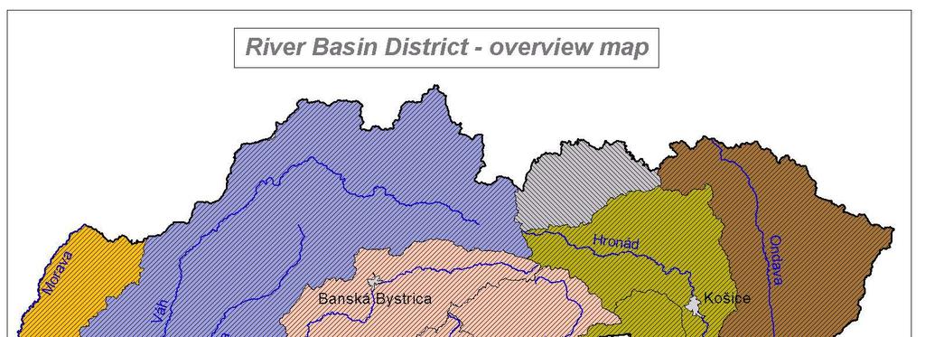
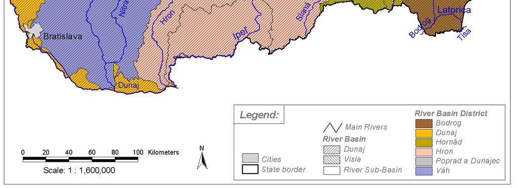
4 Slovak territory is divided in to the six catchment areas, from which five are included to the International Danube river catchment area and one to the International Vistula river catchment area. Their overview is shown in table 2. Basic hydrological characteristics Table 1 Tributaries of Danube River Mouth at Danube Length km Size of catchment km 2 Average discharge m 3.s -1 km total Slovak total Slovak territory profile territory Morava 1 880,2 329,0 127, ,7 mouth Váh 1 766,0 378,0 378, ,8 mouth Hron 1 716,0 284,0 284, ,2 mouth Ipeľ 1 708,2 232,0 232, ,7 mouth Bodrog *) 267,0 15, ,5 state border Hornád **) 270,0 186, ,8 state border Bodva **) 48, ,8 state border Tisa 1 215,0 966,0 6, ,0 state border Other tributaries with size of catchment more than km 2 River Length km Size of catchment km 2 Average discharge m 3.s -1 total Slovak total Slovak territory profile territory Malý Dunaj 120,0 120, ,3 27,8 M.Pálenisko Trstice Čierna voda 55,2 55, ,7 Bernolákovo Nitra 169,0 169, ,5 mouth Žitava 69,2 69, ,3 mouth Kysuca 66,3 66, ,7 mouth Orava 108,3 108, ,0 mouth Rimava 85,0 85, ,6 mouth Slaná 229,0 94, ,0 about Rimava Torysa 129,0 129, ,2 mouth Ondava 146,5 146, ,6 mouth Topľa 129,8 129, ,1 mouth Latorica 184,0 31, ,0 about Ondava Laborec 135,5 135, ,7 mouth Uh 126,0 20, ,1 mouth Poprad 174,2 144, ,3 Mníšek upon Poprad Dunajec 251,0 16, ,2 Červ.Kláštor Note: *) Tributary of the Tisa river in Hungary **) Tributary of the Slaná river which flows in to the Tisa in Hungary Catchment areas in the Slovak Republic Table 2 International catchment areas Slovak catchment areas RBD Code* (only preliminary code, not official) Size km 2 Danube Danube Váh Hron Bodrog Hornád VISTULA Poprad and Dunajec Slovakia TOTAL *Note: Official coding system of river basins and competent authorities in the Slovak Republic has not yet been resolved in the time of submission of this Report. There is still being work on preparation and generation of the report. 3
5 POSITION OF THE MAJOR SLOVAK RIVERS WITHIN EUROPEAN RIVER SYSTEM Figure 1 Visla Poprad Dunajec Dunajec Visla Watershed divide of the Black Sea and Baltic Sea Morava Váh Hron Ipeľ Tisa Bodrog Tisa Bodva Hornád Tisa Nitra Váh Slaná Slaná Tisa Danube Danube Danube VÚVH Bratislava 4
6 5
7 A.2. List and characteristic of competent authorities List of Competent Authorities for the application of the rules of WFD within territory if Slovak Republic 1. The Ministry of the Environment of the Slovak Republic, Nám. Ľ. Štúra 1, Bratislava, Slovak Republic 2.i Trnava Regional Environment Authority, Kollárova 8, Trnava, Slovak Republic 2.ii Žilina Regional Environment Authority, Nám. M. R. Štefánika 1, Žilina, Slovak Republic 2.iii Banská Bystrica Regional Environment Authority, Nám. Ľ. Štúra 1, , Banská Bystrica, Slovak Republic 2.iv Prešov Regional Environment Authority, Nám. mieru 2, Prešov, Slovak Republic 2.v Košice Regional Environment Authority, Komenského 52, Košice, Slovak Republic 6
8 A.2.1. The Ministry of the Environment of the Slovak Republic 1. Name and address of competent authority Name: The Ministry of the Environment of the Slovak Republic Acronym: MŽP SR CA Code: 0 (only preliminary code, not official) Address: Number: 1 Street: Nám. Ľ. Štúra City: Bratislava Postal Code: Web-site: 2. Legal status of the competent authority The Ministry of the Environment of the Slovak Republic is the central state authority in the field of development and protection of the environment, including the water management, water quality protection and protection related to amount of waters, rational use of waters, as well as fishing excluding breeding of fish on the basis of the Act No.139/2003 Coll. by which the Act No.575/2001 Coll. on organization of the activity of the government and on organization of central state administration in sound of later regulations is amended and supplemented and by which the Act No. 312/2001 Coll. on Civil Service and on amendments to certain acts, in the sound of later regulations is amended. 3. Responsibilities of the Ministry of the Environment of the Slovak Republic in line with the new Act on Waters and on changes of the Act No. 372/1990 Coll. on offences as later amended (Water Act) approved by National Council of the Slovak Republic which is to come into force in 1 st of July The Ministry of the Environment of the Slovak Republic (MŽP SR) as a central state administration authority of the water administration and water management is responsible for: a) the execution and management of the state water administration, b) providing of water occurrence, the evaluation of surface and ground water status, the establishment of the environmental objectives, c) providing of development, approval, up-dating and application of the monitoring programmes, d) development of programmes of measures and timetable of their realization for enhancing the surface water quality intended for abstraction of water used for drinking purposes, e) providing the identification of bathing waters f) development of the programmes of measures against erosion and enhance of retention capabilities of the sub-rivers basins and control of their implementation g) development of the river basin management plans, the Water Plan of Slovakia and their coordination within the international cooperation in the Danube River Basin and Vistula River Basin, 7
9 h) processing of conceptions and development programmes in the field of water management and is also responsible for central management of activities on administration and operation of water courses and water constructions owned by the state, that serve to fulfilling the functions of water course, i) issuing statements on investments concerning constructions, that can have significant impact on handling of waters, water protection and water status, j) regular revaluation of range of the designated sensitive areas and range of vulnerable zones, k) development and actualization of the programme on reduction of water pollution by priority substances and priority hazardous substances, l) providing the register on water courses and their basins, m) making decisions on the possibility of transferring the administration of minor water course or its integrated passage to the administration of further state organization, n) providing issues centrally on the division of execution of expert technical security control and arranging and rearranging water constructions to suitable category and charging state organization by execution of expert technical-security control over water constructions arranged to I. and II. category, o) execution of main state water protecting supervision. The Ministry is fulfilling the tasks resulting from the membership of the Slovak Republic in the European Union, as well as providing coordination of the above mentioned tasks with competent central state administration bodies, with member countries of European Union and other states located within the international Danube River Basin and delivers reports on fulfilling the tasks resulting from legal acts of European Communities and European Union on water protection mainly in the field of: a) establishment of competent authorities and their responsibilities for water management planning process, b) undertaking of analysis of characterisation the river basin districts, review of the impact of human activity on the status of surface waters and groundwaters, and economic analysis of water use, c) the monitoring and evaluation of the status of surface water, groundwater and the protected areas, according to monitoring programmes d) water management planning and applying of programmes of measures by three months from their and their publishing and up-dating. Role of competent authorities specified by the Water Framework Directive in the river basin district: Identification of river basin districts Identification of water bodies Identification of heavily modified and artificial water bodies Identification of protected areas Compilation and maintenance of register of protected areas Characterisation and classification of water bodies Definition of reference conditions Review of impact of human activity Economic analysis of water use Identification of derogations 8
10 Monitoring of surface waters Monitoring of groundwaters Monitoring of protected areas Take account of the principle of recovery of costs for water services Establishment of emission controls etc. Implementation of emission controls etc. Establishment of programme of measures Implementation of programme of measures Prior regulation of discharges Regulation of abstractions Ensuring compliance with prohibition of discharges of pollutants to groundwater Implementation of measures to reduce pollution from accidents etc. To inform public Provide consultations for public Implementation of controls on priority substances Tasks mentioned below are provided by the Ministry of the Environment of the Slovak Republic in cooperation with organizations that are under its supervision: Slovak Hydrometeorological Institute monitoring, identification of reference conditions, identification of groudwaters bodies Water Research Institute identification of bodies of surface waters, intercalibrating sites, identification of heavily modified and artificial water bodies, identification of protected areas, establishment and record adding of protected areas, summary of pressures of human activities Slovak Water Management Enterprise, s.e. Banská Štiavnica economic analyses of use of waters and cooperation within monitoring of the surface waters status quality Slovak Environment Agency submission of reports. 4. Membership Ministry of the Environment as Competent Authority for implementation WFD methodically regulates regional environment authorities in the field of fulfilling the tasks resulting from river basin management plans and programmes of measures targeting to achieve environmental objectives. Regional Environmet Authorities: provide coordination of fulfilling tasks resulting from river basin management plans and programmes of measures targeting to achieve environmental objectives, in the issues related to transboundary waters, the regional environment authorities execute state water administration after consulting with the Ministry of the Environment, in cases when decisionmaking can influence vitaly the course, character or designation the state border, the Ministry of Interior of the Slovak Republic is involved into decisionmaking too. 9
11 5. International relationships Slovakia is the signatory of The Convention on Protection and Use of Transboundary Watercourses and International Lakes and The Convection on Cooperation for the Protection and Sustainable Use of the River Danube. With respect of the The Convection on Cooperation for the Protection and Sustainable Use of the River Danube, the International Commission for the Protection of the Danube River (ICPDR) has been established in order to coordinate the implementation of the WFD in this international water basin. Transboundary water commissions based on bilateral treaties between Slovakia and its neighbouring states will serve as platforms for transboundary co-ordination in the implementation of the WFD. They will predominantly cover issues of bilateral relevance. Issues of basin-wide relevance are solved at the level of ICPDR. Besides the above mentioned conventions, Slovakia has bilateral intergovernmental conventions concluded on boundary waters and on cooperation with neighbouring countries in the field of environment protection. Especially following forms of cooperation are concerned: Treaty between the Czechoslovak Socialist Republic and the Republic of Austria on dealing with water management issues relating to border waters (date of signing: 7 December 1967, place of signing: Vienna, entry into force: 18. March 1970) After formation of the Slovak Republic in 1993 the Treaty was taken in the legal succession by contracting parties. Agreement between the Governments of the Hungarian People's Republic and of the Czechoslovakian Socialist Republic on the regulation of water management issues of transboundary waters (date of signing: 31 May 1976, place of signing: Budapest, entry into force: 31 July 1978) After formation of the Slovak Republic in 1993 the Treaty was taken in the legal succession by contracting parties. Agreement on cooperation in branch of environmental protection between the Slovak Republic and the Czech Republic (date of signing: 29 October 1992, place of signing: Prague, entry into force: 1 January 1993) Treaty on good neighbouring and friendly relationships and cooperation between the Slovak Republic and the Czech Republic (date of signing: 23 November 1992, place of signing: Bratislava, entry into force: 1 July 1993) Agreement between the Government of the Slovak Republic and the Government of Ukraine on water management issues on transboundary waters (date of signing: 14 June 1994, place of signing: Bratislava, entry into force: 15 December 1995) Agreement between the Government of the Slovak Republic and the Government of the Polish Republic on water management on transboundary waters (date of signing: 14 May 1997, place of signing: Warsaw, date of validity: 6 December 1999) Treaty on common state border between the Slovak Republic and the Czech Republic (date of signing: 4 January 1996, place of signing: Židlochovice, entry into force: 25 July 1997) Agreement between the Government of Republic of Hungary and the Government of Republic of Slovakia on Cooperation in the field of environmental protection and Nature 10
12 Conservation (date of signing: 12 February 1999, place of signing: Bratislava, entry into force: 27 May 1999) Agreement between the Government of the Slovak Republic and the Government of the Czech Republic on transboundary water cooperation (date of signing: 16 December 1999, place of signing: Židlochovice, entry into force: 16 December 1999) At present these treaty documents has been in the ratify process: Treaty between the Slovak Republic and the Austria Republic on water management cooperation on boundary waters (date of signing: December 2001, place of signing: Bratislava, date of validity: in the ratify process on both contracting parties) Agreement between the Government of the Slovak Republic and the Hungarian Republic on cooperation on boundary waters Negotiations have been currently in the process among water management experts of both contracting parties on proposal of an agreement that is in line with EU Water Framework Directive. This proposal of Agreement will be base for further negotiations among Slovak and Hungarian parties, as well as with the participation of appropriate ministries of the Slovak Republic Ministry of Foreign Affairs of the Slovak Republic, Ministry of Finance of the Slovak Republic, Ministry of the Environment of the Slovak Republic, Ministry of Interior of the Slovak Republic and Ministry of Transports, Posts and Telecommunications of the Slovak Republic. Cooperation of the Slovak Republic in the Vistula international river basin has been realized by the Ministry of the Environment of the Slovak Republic through Agreement between the Government of the Slovak Republic and the Government of the Polish Republic on water management on boundary waters. 11
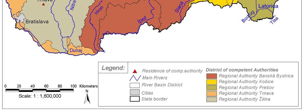
13 A.2.2. Regional environment authorities - designated for the application of the rules of WFD within the river basin district lying within their territory Competent Authority in matters related to state water administration in appropriate river basin district is Regional Environment Authority. On the basis of the decree to be adopted by the Ministry of the Environment in which details on river basin districts, environmental objectives and on water planning are established, at the territory of the Slovak Republic will be marked 6 river basin districts and 5 local competent authorities having control over them Regional Environment Authorities. Prepared decree has been in the approval process (to be adopted ) in time of submission of this report. 1. Name and address of competent authority Name: Trnava Regional Environment Authority Acronym: KÚ ŽP Trnava CA code: 2 (not official, only preliminary code) Address: Number : 8 Street: Kollárova City: Trnava Postal Code: web page: - Name: Žilina Regional Environment Authority Acronym: KÚ ŽP Žilina CA code: 5 (not official, only preliminary code) Address:Number : 1 Street: Nám. M. R. Štefánika City: Žilina Postal Code: web page: - Name: Banská Bystrica Regional Environment Authority Acronym: KÚ ŽP Banská Bystrica CA code: 6 (not official, only preliminary code) Address:Number : 1 Street: Nám. Ľ. Štúra City: Banská Bystrica Postal Code: web page: - 12
14 Name: Prešov Regional Environment Authority Acronym: KÚ ŽP Prešov CA code: 7 (not official, only preliminary code) Address:Number : 2 Street: Nám. mieru City: Prešov Postal Code: web page: - Name: Košice Regional Environment Authority Acronym: KÚ ŽP Košice CA code: 8 (not official, only preliminary code) Address:Number : 52 Ulica: Komenského City: Košice Postal code: web page: - 2. Legal status of the competent authority: According to the Act No 525/2003 Coll. on State administration of environment protection and on amendments to certain acts, Regional Environment Authorities execute state administration on environment protection at areas of regional territory. State water administration, in the field of river basin districts that are in line with WFD, is in line with approved new Water Act which is to come into force in 1 st of July 2004, administered and coordinated by locally appropriate competent authority. More details will be published in prepared decree of the Ministry of the Environment of the Slovak Republic, where details on river basin districts designation, environmental objectives and water planning are appointed. Area limit of each competent regional authority is mentioned in Annex I. of the above designated decree. According to the Act No.139/2003 Coll. that amends and up-dates the Act No. 575/2001 Coll. on organization of activities of the government and organization of the central state administration and as later amended, in the Act No. 312/2001 on Civil Service and on amendments to certain acts, as later amended, activities of Regional Authorities are controlled and methodically supervised by the Ministry of the Environment of the Slovak Republic. 13
15 3. Responsibility of the Regional Environment Authorities in line with the new Act on Waters and on changes of the Act No. 372/1990 Coll. on offences as later amended (Water Act) approved by National Council of the Slovak Republic which is to come into force in 1 st of July Administration of territory of the Slovak Republic is covered by 5 specialized institutions of state authorities Name Territorial scope i) Trnava Regional Environment Danube River Basin District Authority ii) Žilina Regional Environment Authority Vah River Basin District iii) Banská Bystrica Regional Environment Authority Hron River Basin District iv) Prešov Regional Environment Authority Bodrog River Basin District Poprad and Dunajec River Basin Districts v) Košice Regional Environment Authority Hornád River Basin District Regional Environment Authority in matters related to state water administration is responsible for : a) decisionmaking in administrative procedure on the first level of state water administration in line with the Water Act if dealt with: - international waters and boundary waters - water construction and related water management interfering with or influencing area of two or more administrative districts b) resolutions in matters of administrative procedure on the first level and in matters concerning boundary watercourses c) keeping records on waters d) delegation of exception to construct and expand oilducts and another facilities for transporting hazardous substances within protected watermanagement areas e) execution of state water protecting supervision within its competence and deciding on measurements for constraint and improvement or abolishing of production or related activities Regional Environment Authorities : - in the issues related to boundary waters, the regional environment authorities execute state water administration after consulting with the Ministry of the Environment, in cases when decisionmaking can influence vitally the course, character or designation the state border, the Ministry of Interior of the Slovak Republic is involved into decisionmaking too - provide coordination of fulfilling tasks resulting from river basin management plans and programmes of measures targeting to achieve environmental objectives, - in line with legally binding announcement are allowed to: proclaim water suitable for bathing and take the steps of legal measurements proclaim water suitable for irrigation and take the steps of legal measurements designate surface waters as waters suitable for life and reproduction of fish, 14
16 especially indigenous species and place measurements issue legally binding part of river basin management plan, where programme of measurements is covered as well adapt, constrain, or abolish using waters for navigation Role of Competent Authorities specific to the Water Framework Directive in the River Basin District: Establishment of emission controls etc. Implementation of emission controls etc. Establishment of programme of measures Implementation of programme of measures Prior regulation of discharges Regulation of abstractions Ensuring compliance with prohibition of discharges of pollutants to groundwater Implementation of measures to reduce pollution from accidents etc. Public information Public consultation Implementation of controls on priority substances 4. Membership Regional Environment Authorities are in the field of fulfiling the tasks resulting from river basin management plans and programmes of measures methodically directed by the Ministry of the Environment of the Slovak Republic, which is competent authority for implementation WFD. Regional Environment Authorities provide methodical supervision and guidance over District Environment Authorities in their territories. Regional Authorities, in order to provide required management of water basins and supervision of following the specified environmental issues, are in close cooperation with water courses administrator ( branch offices of the Slovak Water Management Enterprise, s.e. Banská Štiavnica, another administrators of small water courses) and the Slovak Environment Inspectorate. 5. International relationships In matters related to boundary waters Regional Environment Authorities execute state water administration respecting at the same time territorially bounded intergovernmental agreements. According to the Water Act, Regional Authorities in matters connected to boundary water courses provide state administration after negotiation with the Ministry of the Environment of the Slovak Republic, and, in cases when decisionmaking can influnce vitaly the course, character or designation of the state border, the Ministry of Interior of the Slovak Republic is involved into decisionmaking too. Regional Environment Authorities do not enter directly negotiations among contracting parties of appropriate agreements on boundary waters, The Convention on 15
17 Protection and Use of Transboundary Watercourses and International Lakes, as well as The Convention on Cooperation for the Protection and Sustainable Use of the River Danube. Activities and decisions of regional authorities in transboundary water matters are managed through negotiation with the Ministry of the Environment, or Ministry of Interior of the Slovak Republic. Reference of Competent Authorities to agreements adopted by the Slovak Republic is as follows: Intergovernmental agreements Competent Authority Ministry of the Environment of Treaty between the Czechoslovak Socialist Republic the Slovak Republic (MŽP SR) in and the Republic of Austria on dealing with water cooperation with: management issues related to border waters Regional Environment Authority (KÚ ŽP) Bratislava. MŽP SR in cooperation with: Agreement between the government of the Czechoslovak Socialist Republic and the government of the Hungarian People s Republic on the regulation of water management related issues of transboundary waters Agreement between the Government of the Slovak Republic and the Government of Ukraine on Water Management Issues on transboundary waters Agreement between the Government of the Slovak Republic and the Government of the Polish Republic on water management issues on transboundary waters Agreement between the Government of the Slovak Republic and the Government of the Czech Republic on transboundary water cooperation Regional Environment Authority (KÚŽP) Bratislava, KÚ ŽP Trnava, KÚ ŽP Nitra, KÚ ŽP Banská Bystrica, KÚ ŽP Košice. MŽP SR in cooperation with: KÚ ŽP Košice, KÚ ŽP Prešov. MŽP SR in cooperation with: KÚ ŽP Žilina, KÚ ŽP Prešov. MŽP SR in cooperation with: KÚ ŽP Bratislava, KÚ ŽP Trenčín, KÚ ŽP Žilina. 16
18 17
19 B. GEOGRAPHICAL COVERAGE OF INDIVIDUAL RIVER BASIN DISTRICTS AND LIST OF APPROPRIATE COMPETENT AUTHORITIES B.1. Danube River Basin District B.1.1. Geographical coverage of the Danube River Basin District The Danube river catchment area includes the Danube and Morava sub-basins. Northern and north-western boundaries of the Danube River catchment area are formed by border between Slovakia and Czech Republic (Morava River), western boundary is formed by border with Austria (Morava and Danube rivers) and south-wester and southern boundary are formed by border with Hungary (Danube river). Eastern boundary passes from border between Slovakia and the Czech republic elevation point Veľká Javorina (970 m a.s.l..) in the mountain Biele Karpaty and continues by passing over the mountain crest of Malé Karpaty up to the Slovak Capital Bratislava. At this point it passes in south-east direction near the Gabčíkovo Water Work than it turns to surrounding of the city Veľký Meder and in south-east direction it returns to the Danube up to mouth of the Váh river. Territory situated in north of the Danube river between Váh and Ipeľ estuaries forming triangle near the city of Hurbanovo is included also in the Danube river catchment area. The Danube river catchment area covers following geo-morphological regions: Záhorská nížina, Podunajská nížina, Juhomoravská panva within the eco-region Maďarská nížina; Slovak-Moravian Carpathian Mountains, Fatra Tatra region. Matra Slana region within the eco-region Hurbanovo. Maximum vertical dissection - energy of relief expressed as difference between maximal and minimal altitudes is given by value of 816 m a.s.l. (Čupec) 106 m a.s.l. (confluence of Ipeľ river with the Danube) = 710 meters. The total area of the river basin is about km 2. The main water courses of the catchment area are Danube and Morava. Slovak stretch of the Danube river belongs to upper part of the middle stream. From inflow on the Slovak territory it forms 7.5 km long border between Slovakia and Austria, then it flows over Slovak territory in length of 22,5 km and finally 142 km long stretch of river forms border between Slovakia and Hungary. The main tributaries of the Danube river in Slovak territory are: Morava, Váh, Hron and Ipeľ. Except of Morava, all tributaries belong to other river basin areas. Long-term average discharge of the Danube river at Bratislava is m 3.s -1. Type of runoff regime is of alpine with dominance of snow regime. Catchment area covers different climatic regions moderate warm, moderate humid with moderate winter, upland to warm, dry with moderate winter and longer sunlight period. Long-term average annual air temperature varies from 7 C to 10 C. Long-term average precipitation varies from 650 mm.r -1 to 550 mm.r -1. The Morava river rises in the Czech Republic under Králický Snežník mountain in m a.s.l. and it flows on the Slovak territory in point of confluence with Sudoměřický potok (brook). It forms boundary river by its whole length in the Slovak territory. It flows in 18
20 to the Danube river near Devin in 136 m a.s.l. Morava s main Slovak tributaries are Myjava, Rudava, Malina. Long-term average discharge of the Morava river in its estuary is 118,7 m 3.s -1. Type of discharge regime is of rain-snow regime. The Lower Morava river basin belongs to temperate climatic region. Long-term average annual air temperature varies form 7 C to 9 C. Long-term average precipitation varies from 700 mm.r -1 to 600 mm.r -1. B.1.2. List and characteristic of competent authorities for the application of the rules of WFD within the Danube River Basin District a) List of competent authorities 1. The Ministry of the Environment of the Slovak Republic Name: The Ministry of the Environment of the Slovak Republic Acronym: MŽP SR CA Code: 0 (only preliminary code, not official) Address: Number: 1 Street: Nám. Ľ. Štúra City: Bratislava Postal Code: Web-site: 2. Trnava Regional Environment Authority Name: Trnava Regional Environment Authority Acronym: KÚ ŽP Trnava CA code: 2 (not official, only preliminary code) Address: Number : 8 Street: Kollárova City: Trnava Postal Code: web page: - b) Characteristics of competent authorities Characteristics of competencies and tasks of the Ministry of Environment of the Slovak Republic as a competent and coordinating body as far as implementation of WFD in the Slovak Republic, has been processed in the part A.2.1. Characteristics of competencies and tasks of the Trnava Regional Environmental Authority as competent body for claiming rules and principles of WFD in the Danube River Basin District has been processed in the part A
21 B.2. Váh River Basin District B.2.1. Geographical coverage of the Váh River Basin District Territory of the Váh river catchment area is formed by relatively wide bend, which passes over High Tatras and upper Orava up to the Danube river. Northern boundary is formed by state border between Slovakia and Poland, north-western boundary is formed by state border between Slovakia and the Czech Republic. Western boundary line passes from elevation point Veľká Javorina (970 m a.s.l.) in the mountain system Biele Karpaty over the mountain crest of Malé Karpaty up to Bratislava and then continues in south-eastern direction near Gabčíkovo Water Work up to the Váh estuary in Komárno. At that point it takes northern direction through the city of Hurbanovo, then follows Žitava and Hron upland divide to the north as far up as mountains Pohronský Inovec. Then boundary follows mountain crest of the Vtáčnik and it turns in north-eastern direction passing mountain crests of Veľká Fatra and continues to the east through major mountain crest of Low Tatras up to Kráľova Hoľa ( m a.s.l.). Here it turns to the north to border with Poland. Territory of the Váh catchment area covers following geo-morphological regions: Slovak-Moravian Carpathian, Západné a Stredné Beskydy, Podhôlno-magurská region, Fatransko-tatranská region, Slovenské stredohorie within the eco-region Karpaty and Danubian lowland in eco-region Hungarian plain. Maximum vertical dissection is given by values of meters above sea level (Kriváň) 106 m.a.s.l. (estuary) = meters. The total area of the river basin is about km 2. The river system is characterized by long relatively narrow river and brook valleys. The Váh river is formed by confluence of the Black Váh river (rises under Kráľová Hoľa) and the White Váh river (rises in High Tatras mountains) and it flows in to the Danube river in Komarno.. Long-term average discharge of the Váh river at its mouth is 195,8 m 3.s -1 (including rivers Nitra and Malý Dunaj). Types of runoff regime: temporarily snow regime in alpine regions and rain-snow regime in highland- lowland regions. The Váh River basin covers various climatic regions from cold mountain to warm dry regions with moderate winter with longer sunlight period. Long-term average annual air temperature varies from 0 O C to 9 O C. Long-term average rainfall are in range of mm.r mm.r -1. Its main right tributaries are: Belá, Smerčianka, Jalovecký potok, Kavčianka, Orava, Varinka, Kysuca, Vlára, Malý Dunaj. Its main left tributaries are: Štiavnica, Demänovka, Križianka, Ľupčianka, Revúca, Ľubochnianka, Turiec, Rajčianka and Nitra with tributary Žitava. The major tributaries of the Váh River with catchment area larger than km 2 include following rivers: Orava, Kysuca, Malý Dunaj, Nitra along with Žitava. The Orava river is formed by confluence of the White and Black Orava rivers. The White Orava river basin is whole situated on the Slovak territory and the most of Black Orava river basin is situated on the Polish territory. The White Orava rises in Oravskí Magura under the Paráč hills in meters a.s.l. The mouth of White Orava is at elevation point of 430 meters a.s.l. and simultaneously it is the lowest point of the river basin. Baníkov meters a.s.l. is the highest point of its river basin. The length of the Orava river is 108,3 km. 20
22 The Orava river basin has been divided by the construction of the Orava dam water work in to two parts: - the White Orava river basin and its tributaries Klinianka, Mútnianka, Veselianka, Hruštínka including the rivers flowing directly to the Orava water reservoir: Polhoranka, Black Orava, Jelešňa - the Orava river basin from dam profile of the Orava dam up to its outfall in to the Váh river. The major tributaries are: Oravica, Studený potok and Zázrivka Long-term average discharge at mouth of the Váh river is 36,0 m 3.s -1. Total catchment area is km 2, from which the area of km 2 is situated on Slovak territory and the rest on the territory of Poland. The Kysuca river rises in Javorníky mountains in 940 meters a.s.l. The highest point of the river basin is meters a.s.l., the low-down point is in 330 meters a.s.l. The river lengt is 66,3 km. The major tributaries of the Kysuca river are its left tributaries: Čierňanka, Oščadnica and Bystrica. Long-term average discharge at river mouth to the Váh river is17,7 m 3.s -1. The area of 988 km 2 from total catchment area of km 2 is situated on the Slovak territory and the rest on the territory of the Czech Republic. The Malý Dunaj river, formerly natural branch of the Danube, is basically artificial stream with regulated discharge regime. It is feeded from the Danube river by intake structure in Bratislava Pálenisko. Relaying of the outfall of Malý Dunaj in to the Váh river near Kolárovo was carried out in order to eliminate negative effects of the Gabčíkovo waterwork. Vertical relief dissection is minimal (130 meters a.s.l. 106 meters a.s.l.). The stream length is 120 km. Hydrographic system is formed by network of mutually connected hydro-melioration channels. The major right channels and streams flowing into the Malý Dunaj are: Klátovské rameno (branch), channel Gabčíkovo-Topoľníky, Chotárny kanál (channel) and Kolárovský kanál (channel). The major left tributaries are: Šúrsky kanál, Čierna voda a Stará Čierna voda. Long-term average discharge at Malé Pálenisko profile is 19,3 m 3.s -1, while at Trstice profile it is 27,8 m 3.s -1. The river basin is oriented from the north-west to south-east. Its catchment area is km 2. The Čierna voda river has characteristics of natural lowland stream with any meanders, which was formed by concentration of more small brooks in foothill depression of the Malé Karpaty mountain system. The river begins at sluice structure of the Šúrsky kanál (channel) in altitude of 130 meters a.s.l. According to hydrological classification, the Malý Dunaj is receiving river of the Čierna voda. The Čierna voda flows into the Malý Dunaj by artificially constructed relaying in the cadastre of the Čierna Voda municipality in altitude of 115 meters a.s.l. The relaying was constructed for diversion of the Čierna voda and Dolný Dudváh flood waters directly to the Malý Dunaj. From the site of relaying, the natural stream channel flows downstream as the Stará Čierna voda river, which is hydrologically classified as single tributary of the Malý Dunaj river and its mouth is situated under the rural municipality of Dolný Chotár. Maximum altitude in the Čierna voda river basin is 768 meters a.s.l. The length of the river up to its relaying is 55,2 km. The major tributaries of the Čierna voda are its left tributaries - Dolný Dudváh and Stoličný potok. The less important left tributaries are Mlynský potok, Slováčkov kanál and Blatina. The right tributaries are: Šábsky kanál, Strakatá voda, Ľadová voda, Vajnorský 21
23 potok, Blahutov kanál and Chlebnický kanál. Long - term average discharge at Bernolákovo profile is 0,7 m 3.s -1, average discharge in the year 2000 at profile of relaying mouth was 2,2 m 3.s -1. The total area of the river basin is km 2. The Nitra river rises under the Fačkovské sedlo (mountain saddle) in 780 meters a.s.l.. The highest point of the river basin is on Vtáčnik elevation point in meters a.s.l. The mouth of Nitra is on elevation point of 108 meters a.s.l. The river length is 169 km. The major right tributaries of the Nitra river are: Nitrica, Bebrava, Radošinka, Dlhý kanál and left tributaries are: Handlovka and Žitava. Long-term average discharge at river mouth is 22,5 m 3.s -1. The Nitra river basin has shape of rectangle elongated in north-south direction. The area of river basin is km 2. The Žitava river is the major left tributary of the Nitra river. It rises in Pohronský Inovec (575 meters a.s.l.). The mouth of Žitava relaying is in 119 meters a.s.l. The river length is 69,2 km. More important tributaries of the Žitava river are: right tributary Hostiansky potok and left tributaries Širočina and Liska. Long-term average discharge at river mouth is 4,3 m 3.s -1. The area of the river basin is 907 km 2. The river and its whole river basin are oriented in north-south direction. B.2.2. List and characteristic of competent authorities for the application of the rules of WFD within the Váh River Basin District a) List of competent authorities 1. The Ministry of the Environment of the Slovak Republic Name: The Ministry of the Environment of the Slovak Republic Acronym: MŽP SR CA Code: 0 (only preliminary code, not official) Address: Number: 1 Street: Nám. Ľ. Štúra City: Bratislava Postal Code: Web-site: 2. Žilina Regional Environment Authority Name: Žilina Regional Environment Authority Acronym: KÚ ŽP Žilina CA code: 5 (not official, only preliminary code) Address: Number : 1 Street: Nám. M. R. Štefánika City: Žilina Postal Code: web page: - 22
24 b) Characteristics of competent authorities Characteristics of competencies and tasks of the Ministry of Environment of the Slovak Republic as a competent and coordinating body as far as implementation of WFD in the Slovak Republic, has been processed in the part A.2.1. Characteristics of competencies and tasks of the Žilina Regional Environmental Authority as competent body for claiming rules and principles of WFD in the Váh River Basin District has been processed in the part A
25 B.3. Hron River Basin District B.3.1. Geographical coverage of the Hron River Basin District The Hron river catchment area includes the Hron, Ipeľ, Slana and Rimava sub-basins. Northern boundary passes over the major mountain crest of the Low Tatras from Kráľova Hoľa (1 948 m a.s.l.) to the elevation point Ostredok (1 592 m a.s.l.) in Veľká Fatra. Northwest boundary passes over mountain crests of Veľká Fatra and continues by western boundary of river basin area over the mountain crest of Vtáčnik in south direction up to the elevation point Dlhý vrch (287 m a.s.l.) in Podunajská pahorkatina. Southern boundary passes from Dlhý vrch to border between Slovakia and Hungary and then follows border up to confluence point of the Rimava and Slana, at that point begins eastern boundary, first passing along border with Hungary to Domica cave, then continuing in north-eastern direction over the mountain crest of Slovenský Kras and after that it turns near village Bôrka and passes in north-western direction over the mountain crests of Slovenské rudohorie to Low Tatras mountains - to root of mountain Kráľová Hoľa. According to geo-morphological conditions, the Hron River catchment area is included in following regions: Fatra Tatra region, Slovenské rudohorie, Slovenské stredohorie and region Martinsko Slanská in eco-region Karpaty, Podunajská nížina a Lučenecko-košická nížina in eco-region Maďarská nížina. Maximum vertical dissection - energy of relief expressed as difference between maximal and minimal altitudes is given by value of meters above sea level (Ďumbier) 106 m.a.s.l. (confluence of Hron river and Danube) = meters. Hydrological area of river basins: Hron 5465 km 2 Ipeľ 3649 km 2 Slaná 3217 km 2 Rimava 1378 km Total Horn river basin area km 2 Major water courses of the catchment area are Hron, Ipeľ, Slaná and Rimava. The Hron river rises in the mountain system of Kráľova Hoľa in the Low Tatras mountains in 106 m a.s.l., its total length is 284 km and it flows in to the Danube river. Long-term average discharge at mouth of the Hron river is 55,2 m 3.s -1. Types of runoff regimes - from temporarily snow regime in alpine regions to rain-snow regime in highlandlowland regions. Its main right tributaries are Bystrica, Kremnický potok, Lutilský potok and Paríž. Its main left tributaries are Čierny Hron, Slatina and Sikelnica. The Hron river basin covers various climatic regions from cold mountain to warm, dry regions with moderate winter with longer sunshine period. Long-term average annual air temperature varies from 0 C to 10 C. Long-term average precipitation is in range of mm.r mm.r
26 The Ipeľ river rises in the west part of mountain system Slovenské rudohorie under Čierťaž in m a.s.l., length of river valley is 232,5 km. Ipeľ river forms boundary stream from village Muľa to its estuary to the Danube river near Chľab in 101 m a.s.l. (except of approx. 24 km long river stretch between Tešmák and Ipeľský Skolec, where Ipeľ flows through Slovak territory). Long-term average discharge of the Ipeľ river at outfall in to the Danube river is 21,7 m 3.s -1. Main tributaries of the Ipeľ in Slovak territory are right tributaries - Tuhársky potok, Tisovník, Krtíš, Krupinica and Štiavnica. The main left tributary is the river Suchá. The Ipeľ river basin includes different climatic regions from cold mountain to warm, dry regions with moderate winter with longer sunshine period. Long-term average annual air temperature varies from 6 C to 10 C. Long-term average precipitation is in range between 800 mm.r mm.r -1. The Slaná river rises in mountains Stolické vrchy under the Stolica on elevation point of meters a.s.l.. Total length of the Slovak stretch is 94,3 km. It flows into the Tisa river in Hungarian territory. The Slaná river crosses Slovak border at elevation point of 151 meters a.s.l. Long-term average discharge of the Slaná river at border profile is 21,6 m 3.s -1, at profile about Rimava is 14,0 m 3.s -1. Types of runoff regimes: snow-rain regime in the central mountain region and rain-snow regime in the upland-lowland regions. Its major right tributaries are Dobšinský potok, Súľovský potok, Rožňavský potok and Čremošná. Its main left tributaries are Štítnik, Muráň, Turiec and Rimava. Climatic regions of the Slaná river basin: cold mountain to warm, moderate dry regions with cold winter. Long-term average annual air temperature varies from 4 C to 8 C. Longterm average precipitation is in range between 1000 mm.r mm.r -1. The area of river basin up to mouth of the Rimava river is km 2 and it is whole situated on Slovak territory. The river basin has shape of irregular quadrangle elongated in east-west direction. The Rimava river rises in mountain system of Slovenské rudohorie in south hillsides of the Fabova hoľa massive in meters a.s.l. The mouth of river is on elevation point of 151 meters a.s.l. The river length is 85 km. Its major tributaries are Klenovská Rimava and Rimavica like right tributaries. Long-term average discharge at site of the outfall in to the Slaná river is 7,6 m 3.s -1. Total area of the Rimava river basin is to the mouth km 2. The river basin has shape of irregular rectangle that is oriented in northwest southeast direction. B.3.2. List and characteristic of competent authorities for the application of the rules of WFD within the Hron River Basin District a) List of competent authorities 1. The Ministry of the Environment of the Slovak Republic Name: The Ministry of the Environment of the Slovak Republic Acronym: MŽP SR CA Code: 0 (only preliminary code, not official) Address: Number: 1 25
Danube River Basin District
 Danube River Basin District Part B National Report BULGARIA Information required according to Art. 3 (8) and Annex I of the EU Water Framework Directive prepared by Ministry of Environment and Water 2
CO-OPERATION IN DANUBE RIVER BASIN - THE ROLE OF SHMI SLOVENSKÝ HYDROMETEOROLOGICKÝ ÚSTAV
 CO-OPERATION IN DANUBE RIVER BASIN - THE ROLE OF SHMI WMO RAVI Hydrological Forum 2016 Oslo, 1 Danube, the 2nd longest in Europe. 2857 km Flows across 10 European states River basin - 817 000 km2 1/11
Implementation of the Water Convention, including its complementary role to the EU Water Framework Directive
 Implementation of the Water Convention, including its complementary role to the EU Water Framework Directive Experience of Serbia Dragana Milovanović Ministry of Agriculture, Forestry and Water Management
Danube River Basin District
 Danube River District Part B - Report 2003 ROMANIA Information required according to Art. 3 (8) and Annex I of the EU Water Framework Directive Reporting deadline: June 22, 2004 Prepared by National Administration
The Danube Experience
 The Danube Experience Dealing with Hydromorphological Issues the Danube Experience Philip Weller Executive Secretary, ICPDR Danube River Basin- Overview The Danube River Basin is the most international
STATUS QUO REPORT ON HYDROLOGICAL ACTIVITIES
 NETWORK OF DANUBE WATERWAY ADMINISTRATIONS South-East European Transnational Cooperation Programme STATUS QUO REPORT ON HYDROLOGICAL ACTIVITIES Document ID: Activity: Improve methods, processes and procedures
From: OECD Tourism Trends and Policies Access the complete publication at:
 From: OECD Tourism Trends and Policies 2014 Access the complete publication at: http://dx.doi.org/10.1787/tour-2014-en Slovak Republic Please cite this chapter as: OECD (2014), Slovak Republic, in OECD
Danube River Basin. a source for transboundary cooperation. Exploring the Results and Potential for Transboundary Water Management Cooperation
 Danube River Basin a source for transboundary cooperation Exploring the Results and Potential for Transboundary Water Management Cooperation Philip Weller ICPDR, Executive Secretary Joint Meeting EUWI
1. Title of your regional initiative: Carpathian Wetland Initiative (CWI)
") Regional Initiatives: Annual Summary Report 2009 and Plan for 2010 1. Title of your regional initiative: Carpathian Wetland Initiative (CWI) 2. Work and activities undertaken 2009 objectives activities
Regional Initiatives: Annual Summary Report 2009 and Plan for 2010 1. Title of your regional initiative: Carpathian Wetland Initiative (CWI) 2. Work and activities undertaken 2009 objectives activities
Transboundary River Management in the Danube Basin
 Southern Illinois University Carbondale OpenSIUC Key Note Presentation World River Day 2011 11-2011 Transboundary River Management in the Danube Basin Philip Weller International Commission for the Protection
Danube River Basin District
 16 th June 2004 Danube River Basin District Part B - Report 2003 REPUBLIC OF MOLDOVA Information required according to Art. 3 (8) and Annex I of the EU Water Framework Directive Reporting deadline: June
Development of the Danube River Basin District Management Plan
 DRAFT-8 DOC-101 23-Nov-2005 Development of the Danube River Basin District Management Plan - Strategy for coordination in a large international river basin River Basin Management Expert Group Prepared
WATER MANAGEMENT IN ROMANIA. Elisabeta CSERWID National Institute of Hydrology and Water Management ROMANIA
 WATER MANAGEMENT IN ROMANIA Elisabeta CSERWID National Institute of Hydrology and Water Management ROMANIA 2 I - Water management in Romania Romania general information Location: S-E Europe Surface: 238,391
ICPDR FP-EG project overview
 ICPDR FP-EG project overview 9 th Steering Group meeting of PA5 of the EUSDR Management of Environmental Risks KÁROLY GOMBÁS CHAIRMAN FLOOD PROTECTION EXPERT GROUP (FP-EG) INTERNATONAL COMISSION OF THE
The Timok River Basin in Serbia
 The Timok River Basin in Serbia UNECE Workshop on Integrated Transboundary Water Resources Management in SEE, Sarajevo, 18-20 May, 2009 Dragana Ninković, Dipl.-Ing. Dušan Dobričić, Dipl.-Ing. Content 1.
Management of a Large The Danube. Mr. Mitja Bricelj ICPDR President Perth,13 October 2010
 Management of a Large International ti River Basin: The Danube Mr. Mitja Bricelj ICPDR President Perth,13 October 2010 From the Black Forest From the Black Forest to the Black Sea Human activities damaged
Wetland Management in Slovakia and the Carpathian Wetland Initiative
 Wetland Management in Slovakia and the Carpathian Wetland Initiative Ján Kadlečík and Tereza Thompson The State Nature Conservancy of the Slovak Republic / Carpathian Wetland Initiative Welcome to Slovakia
Transboundary Water Management in Republic of Macedonia
 12th International Conference EUROPE-INBO 2014 12-15 November 2014, Bucharest, Romania. Transboundary Water Management in Republic of Macedonia Ylber Mirta Head of Department for Waters ymirta@gmail.com
THE IMPLEMENTATION OF EWFD/WFD IN THE REGION OF VOJVODINA WITHIN JOINT SLOVAK-SERBIA SERBIA PROJECTS
 Towards Integrated River Basin Management The 55 th Anniversary of the Founding of the Water Research Institute THE IMPLEMENTATION OF EWFD/WFD IN THE REGION OF VOJVODINA WITHIN JOINT SLOVAK-SERBIA SERBIA
Evian Encounter 2006 The Carpathian Wetland Initiative
 Evian Encounter 2006 The Carpathian Wetland Initiative Results of the 6 th Evian Encounter 15-17 November 2006, Evian, France An activity of the Ramsar Convention project financed by the Danone Group The
LIST OF BENEFICIARIES OF THE CROSS-BORDER COOPERATION PROGRAMME POLAND-SLOVAK REPUBLIC
 LIST OF BENEFICIARIES OF THE CROSS-BORDER COOPERATION PROGRAMME POLAND-SLOVAK REPUBLIC 2007-2013 SHORT DESCRIPTIONS OF PROJECTS CO-FINANCED BY THE EUROPEAN UNION PRIORITY AXIS I DEVELOPMENT OF CROSS-BORDER
Danube River Basin District
 Ministry of Agriculture, Forestry and Water Management June 18 th, 2004 Danube River Basin District Part B - Report 2003 CROATIA Information required according to Art. 3 (8) and Annex I of the EU Water
Transboundary and Not-Tranboundary Aquifers in the Basin
 Second Assessment of Transboundary Rivers, Lakes and Groundwaters under the UNECE Water Convention Transboundary and Not-Tranboundary Aquifers in the Basin Slovak Hydrometeorological Institute Bratislava,
COMMISSION IMPLEMENTING REGULATION (EU)
") 18.10.2011 Official Journal of the European Union L 271/15 COMMISSION IMPLEMENTING REGULATION (EU) No 1034/2011 of 17 October 2011 on safety oversight in air traffic management and air navigation services
18.10.2011 Official Journal of the European Union L 271/15 COMMISSION IMPLEMENTING REGULATION (EU) No 1034/2011 of 17 October 2011 on safety oversight in air traffic management and air navigation services
Presentation from 2015 World Water Week in Stockholm. The authors, all rights reserved. SIWI siwi.org
 Presentation from 2015 World Water Week in Stockholm www.worldwaterweek.org The authors, all rights reserved SIWI siwi.org WORLD WATER WEEK Stockholm, 23 th August 2015 Co-operative water governance: catalyst
"Transboundary coordination according to the FD Directive in the shared river basins of Greece
 Workshop on Transboundary Issues Budapest March 31st April 1st "Transboundary coordination according to the FD Directive in the shared river basins of Greece Katerina Triantafyllou, ECOS Consulting S.A.
Transboundary cooperation. Republic of Hungary
 Transboundary cooperation of the Republic of Hungary Dr. Miklós Varga, János Rémai, Kálmán Papp The Danube river basin in Central-Europe most international basin in the world 17 riparian countries Basin
International Sava River Basin Commission - An example of EU/non EU country cooperation in water management
 International Sava River Basin Commission - An example of EU/non EU country cooperation in water management Improvement and co-operation possibilities in the water sector with non-eu countries Ulm, 29
COMMISSION OF THE EUROPEAN COMMUNITIES. Draft. COMMISSION REGULATION (EU) No /2010
 No /2010") COMMISSION OF THE EUROPEAN COMMUNITIES Brussels, XXX Draft COMMISSION REGULATION (EU) No /2010 of [ ] on safety oversight in air traffic management and air navigation services (Text with EEA relevance)
COMMISSION OF THE EUROPEAN COMMUNITIES Brussels, XXX Draft COMMISSION REGULATION (EU) No /2010 of [ ] on safety oversight in air traffic management and air navigation services (Text with EEA relevance)
Basic criteria: Final HMWB designation for the Danube River
 Basic criteria: Final HMWB designation for the Danube River A joint and harmonised approach Document number: ICWD/346 Annex 13 of the DRBM Plan ICPDR / International Commission for the Protection of the
ACTION PLAN FOR THE PERIOD concerning the STRATEGY ON IMPLEMENTATION OF THE FRAMEWORK AGREEMENT ON THE SAVA RIVER BASIN
 Doc. 1S-26-O-11-5/1-2 ACTION PLAN FOR THE PERIOD 2011-2015 concerning the STRATEGY ON IMPLEMENTATION OF THE FRAMEWORK AGREEMENT ON THE SAVA RIVER BASIN April 2011 Table of Contents INTRODUCTION... 5 1.
Managing environmental risks in the Danube Region
 Environmental Risks Managing environmental risks in the Danube Region www.danubeenvironmentalrisks.eu INTRODUCTION The Danube Region represents one fifth of the European Union s total area and is home
Transboundary cooperation of Ukraine and Hungary in river basin and flood management in the framework of the EU Strategy for the Danube Region
 Transboundary cooperation of Ukraine and Hungary in river basin and flood management in the framework of the EU Strategy for the Danube Region Budapest Water Summit October 09, 2013 Balázs Medgyesy Government
The results of the National Tourism Development Strategy Assessments
 The results of the National Tourism Development Strategy Assessments - 2012 (I) The assessment tool In 2012 the Sustainable Tourism Working Group of the CEEweb for Biodiversity prepared a guidance for
BIOREGIO Carpathians Implementation update
 BIOREGIO Carpathians Implementation update Forestry Working Group Donji Milanovac, 23-24 April 2012 Mircea Verghelet Piatra Craiului National Park 1 Integrated management of biological and landscape diversity
General information The Slovak Republic Bratislava
 Slovakia General information foundation: 1st January 1993 official name: The Slovak Republic capital town: Bratislava size: 49 035 km 2 population: 5 379 445 currency: euro ( ) Location Slovakia is situated
Cross border cooperation between Ukraine and Moldova: achievements, opportunities and problems DANUBE FINANCING AND CAPACITY BUILDING DIALOGUE
 Cross border cooperation between Ukraine and Moldova: achievements, opportunities and problems Igor Studennikov Executive Director Centre for Regional Studies, Odessa, Ukraine Member of the Executive Committee
L 342/20 Official Journal of the European Union
 L 342/20 Official Journal of the European Union 24.12.2005 COMMISSION REGULATION (EC) No 2150/2005 of 23 December 2005 laying down common rules for the flexible use of airspace (Text with EEA relevance)
ARTWEI ARTWEI ARTWEI
 Protection / Management Plans for Natura 2000 areas and Maritime Spatial Plan for internal sea waters - including the Szczecin Lagoon Szczecin, 7th May 2011 Andrzej Zych Inspectorate of Coast Protection
Official Journal of the European Union L 337/43
 22.12.2005 Official Journal of the European Union L 337/43 PROTOCOL on the implementation of the Alpine Convention of 1991 in the field of tourism Tourism Protocol Preamble THE FEDERAL REPUBLIC OF GERMANY,
Structure of presentation
 Inbound tourism Slovak Republic CAPACITY BUILDING PROGRAMME ON TOURISM STATISTICS, Regional Seminar, Vienna (Austria), 1st July 2009 Structure of presentation 1. System of Tourism Statistics 2. Developments
Development of RBMP s In Republic of Macedonia
 Development of RBMP s In Republic of Macedonia Ministry of Environment and Physical Planning Republic of Macedonia RENA Workshop, Istanbul October 15 17 th, 2012 MoEPP Environmental Administration Transposition
Implementation of WFD in Serbia and Montenegro
 Ministry of Agriculture, Forestry and Water Management Directorate for Water Implementation of WFD in Serbia and Montenegro Nikola Marjanovic, PhD Civ. Eng. SERBIA AND MONTENEGRO SERBIA Area: 88.361 km
A Romanian, Hungarian and Ukrainean transboundary basin: Somes - Tisa
 A Romanian, Hungarian and Ukrainean transboundary basin: Somes - Tisa dr. eng. Costica Sofronie, dr. eng. Daniela Radulescu NATIONAL ADMINISTRATION APELE ROMANE Transboundary Network of Basin Organizations
Terms of Reference (ToR) for a Short-Term assignment
 for a Short-Term assignment") Terms of Reference (ToR) for a Short-Term assignment Technical assistance requested Expert for climate change mitigation and adaptation Project Title Outline of the Climate Adaptation Strategy and basin-wide
Terms of Reference (ToR) for a Short-Term assignment Technical assistance requested Expert for climate change mitigation and adaptation Project Title Outline of the Climate Adaptation Strategy and basin-wide
Danube River Basin District
 Danube River Basin District Part A - Roof report Information required according to Art. 3 (8) and Annex I of the EU Water Framework Directive Reporting deadline: June 22, 2004 Prepared by: International
SUMMARY REPORT ON THE SAFETY OVERSIGHT AUDIT FOLLOW-UP OF THE DIRECTORATE GENERAL OF CIVIL AVIATION OF KUWAIT
 ICAO Universal Safety Oversight Audit Programme SUMMARY REPORT ON THE SAFETY OVERSIGHT AUDIT FOLLOW-UP OF THE DIRECTORATE GENERAL OF CIVIL AVIATION OF KUWAIT (Kuwait, 17 to 20 September 2003) International
SLOVAK CONVENTION BUREAU
 SLOVAK CONVENTION BUREAU www.slovakconvention.sk www.slovakia.travel The country where history meets modern day. Would you like to organize a conference or congress in a nice quiet place or directly in
SUSTAINABLE AND INTEGRATED WATER MANAGEMENT IN THE 21 ST CENTURY: ADDRESSING IMMINENT CHALLENGES
 7 th ASEM Sustainable Development Dialogue Danube Mekong Cooperation Initiative SUSTAINABLE AND INTEGRATED WATER MANAGEMENT IN THE 21 ST CENTURY: ADDRESSING IMMINENT CHALLENGES Tentative Programme Budapest,
Framework Agreement on the Sava River Basin and its implementation
 Framework Agreement on the Sava River Basin and its implementation Dejan Komatina, Ph.D. Civ. Eng., Secretary, ISRBC Samo Grošelj, Deputy Secretary Overview Introduction on the Sava river basin Establishment
MEMBER STATES' ANNUAL TOURISM REPORTING TEMPLATE
 MEMBER STATES' ANNUAL TOURISM REPORTING TEMPLATE Article 3 of Council Decision 86/664/EEC 1 of 22 December 1986 establishing a consultation and cooperation procedure in the field of tourism stipulates
CITY OF LYNDEN STORMWATER MANAGEMENT PROGRAM REPORT MARCH 1, 2016
 CITY OF LYNDEN STORMWATER MANAGEMENT PROGRAM 2015 WATER QUALITY MONITORING REPORT CITY OF LYNDEN 300 4 TH STREET LYNDEN, WASHINGTON 98264 PHONE (360) 354-3446 MARCH 1, 2016 This document serves as an attachment
The UNDP/GEF Danube Regional Project
 1 The UNDP/GEF Danube Regional Project Pilot River Basin Management Plan for the Sava River Sub-Basin Andy Garner Environmental Specialist Sava Initiative WG Meeting September 17-18, 2002 GEF Black Sea
CARPATHIAN PARKS DAY 2010 FINAL REPORT
 Summary 2010 was a year full of challenges for the protected areas all over the world. With all the global warming processes ongoing, all the efforts for lowering the carbon emissions and all the public
WELCOME TO SLOVAKIA THE 72 ND IIW ANNUAL ASSEMBLY AND INTERNATIONAL CONFERENCE 2019 BEING HELD. 7 th 12 th July 2019
 WELCOME TO THE 72 ND IIW ANNUAL ASSEMBLY AND INTERNATIONAL CONFERENCE 2019 BEING HELD IN BRATISLAVA SLOVAKIA 7 th 12 th July 2019 The 72 nd IIW Annual Assembly and International Conference is a prestigious
Assessment of Environmental Impacts of the proposed Sectoral Operational Programme for Tourism and Spa Industry
 Unofficial translation of the original document produced in Czech language Assessment of Environmental Impacts of the proposed Sectoral Operational Programme for Tourism and Spa Industry Assessment team:
Ohrid Lake and Prespa Lake, Sub basin s on Crn Drim river basin International Workshop, Sarajevo, Bosna and Hercegovina May 2009
 Ohrid Lake and Prespa Lake, Sub basin s on Crn Drim river basin International Workshop, Sarajevo, Bosna and Hercegovina 18-20 May 2009 Ms. Darinka Jantinska Ministry of Environment and Physical Planning
TRANSBOUNDARY COOPERATION ON WATER MANAGEMENT
 3 rd Istanbul International Water Forum European Regional Process towards the 7 th World Water Forum PLOVDIV TRANSBOUNDARY COOPERATION ON WATER MANAGEMENT Nicola Karnolski - Director of East Aegean Sea
The European Union Strategy for the Danube Region: climate and disaster risk reduction
 The European Union Strategy for the Danube Region: climate and disaster risk reduction Károly Gombás 16.11.2017, Budapest Project co-funded by European Union funds (ERDF) National and transboundary issues
The Czech National Operational Centrum and his funkcion in the case of Emergency
 The Czech National Operational Centrum and his funkcion in the case of Emergency Irena JANSOVÁ Ministry of Interior General Directorate of the Fire and Rescue Service Operation and Information Centre (OIC)
Occurrence of Dry and Wet Periods in Altitudinal Vegetation Stages of West Carpathians in Slovakia: Time-Series Analysis
 Occurrence of Dry and Wet Periods in Altitudinal Vegetation Stages of West Carpathians in Slovakia: Time-Series Analysis 1951-2005 J. Hrvoľ,, J. J Škvarenina,, J. J Tomlain, J. Škvareninová,, P. Nejedlík
BIOREGIO Carpathians. Overview
 BIOREGIO Carpathians Overview Econnect Final Confernce Berchtesgaden, 26-28 September 2011 Mircea Verghelet Piatra Craiului Natinal Park 1 Integrated management of biological and landscape diversity for
BABIA GÓRA DECLARATION ON SUSTAINABLE TOURISM DEVELOPMENT IN MOUNTAIN AREAS
 BABIA GÓRA DECLARATION ON SUSTAINABLE TOURISM DEVELOPMENT IN MOUNTAIN AREAS The participants of the International Workshop for CEE Countries Tourism in Mountain Areas and the Convention on Biological Diversity",
Aszimmetria mint a határ menti kapcsolatok jellemzője: esettanulmány a magyar szlovák határtérségben
 A MAGYAR REGIONÁLIS TUDOMÁNYI TÁRSASÁG XV. VÁNDORGYŰLÉSE Dualitások a regionális tudományban Mosonmagyaróvár, 2017. október 19 20. Széchenyi István Egyetem Mezőgazdaság- és Élelmiszertudományi Kar Aszimmetria
National Civil Aviation Security Quality Control Programme for the United Kingdom Overseas Territories of
 National Civil Aviation Security Quality Control Programme for the United Kingdom Overseas Territories of Anguilla Bermuda British Virgin Islands Cayman Islands Falkland Islands Montserrat St. Helena Turks
MIÑO O AND LIMIA BASINS
 Miño-Sil MIÑO O AND LIMIA BASINS José Álvarez Díaz Sil River Basin District s s Planning Office, Spain WORKSHOP ON TRANSBOUNDARY WATER RESOURCES BUDAPEST, HUNGARY, 8-10 FEBRUARY 2011 INDEX 1. OVERVIEW
MEMBER STATES' ANNUAL TOURISM REPORTING TEMPLATE
 MEMBER STATES' ANNUAL TOURISM REPORTING TEMPLATE Article 3 of Council Decision 86/664/EEC 1 of 22 December 1986 establishing a consultation and cooperation procedure in the field of tourism stipulates
Public Seminar 30 October 2018, Lisbon. Water sector in B&H
 Public Seminar 30 October 2018, Lisbon Water sector in B&H Ministry of Foreign Trade and Economic Relations www.mvteo.gov.ba Boško Kenjić, Head of Department Tel: +387 33 262 155 E-mail: bosko.kenjic@mvteo.gov.ba
~~~ ALPARC The Alpine Network of Protected Areas
 Press pack ~~~ ALPARC The Alpine Network of Protected Areas Le Réseau Alpin des Espaces Protégés La Rete delle Aree Protette Alpine Das Netzwerk Alpiner Schutzgebiete Mreža zavarovanih območij v Alpah
PRESS RELEASE. Address: Hungary, H-1068 Budapest, Benczúr utca 25.
 PRESS RELEASE Participation of the Permanent Representative of Hungary in Danube Commission, Dr. Ivan Gyurcsík at the 7th ASEM Sustainable Development Dialogue, (11-12 September 2018, Budapest, Hungary)
Full name of the institution: Ministry of the Environment of the Slovak Republic
 Implementation of the Ramsar Convention in general, and of the Ramsar Strategic Plan 1997-2002 in particular, during the period since the National Report prepared in 1995 for Ramsar COP6 and 30 June 1998
Catchment and Lake Research
 LARS 2007 Catchment and Lake Research Multilateral versus bilateral agreements for the establishment of river based organizations: comparison of legal, economic and social benefits in the Zambian experience.
STUDY OF HISTORICAL FLOODS IN CENTRAL AND EASTERN EUROPE FROM AN INTEGRATED FLOOD MANAGEMENT VIEWPOINT SLOVAKIA
 World Meteorological Organization STUDY OF HISTORICAL FLOODS IN CENTRAL AND EASTERN EUROPE FROM AN INTEGRATED FLOOD MANAGEMENT VIEWPOINT SLOVAKIA Submitted by: Slovak Hydrometeorological Institute, Bratislava
Cooperation in the Danube River Basin
 Cooperation in the Danube River Basin Mr. Gyula Holló Head of Delegation, Hungary Ms. Jasmine Bachmann ICPDR Secretariat, Vienna 2 Content Facts and figures about the Danube River Basin International Commission
MANAGING FRESHWATER INFLOWS TO ESTUARIES
 MANAGING FRESHWATER INFLOWS TO ESTUARIES Yuna River Hydrologic Characterization A. Warner Warner, A. (2005). Yuna River Hydrologic Characterization. University Park, Pennsylvania: The Nature Conservancy.
Stability Pact for SEE. Working Table II. Sava River Basin Initiative
 Stability Pact for SEE Working Table II Sava River Basin Initiative Background Prior to disintegration of former Yugoslavia, the Sava was a river basin of national interest Now, it belongs to four countries:
ADVISORY CIRCULAR ON LAND USE AND ENVIRONMENTAL MANAGEMENT IN THE VICINITY OF AERODROMES
 Page 1 of 9 1.0 PURPOSE 1. The purpose of this Advisory Circular (AC) is to provide guidance on land use practices and activities in the vicinity of aerodromes. 2.0 REFERENCE 2.1 The Civil Aviation (Aerodromes)
REPUBLIC OF CROATIA MINISTRY OF MARITIME AFFAIRS, TRANSPORT AND INFRASTRUCTURE AGENCY FOR INLAND WATERWAYS
 REPUBLIC OF CROATIA MINISTRY OF MARITIME AFFAIRS, TRANSPORT AND INFRASTRUCTURE AGENCY FOR INLAND WATERWAYS BRATISLAVA, MAY 3rd, 2012 Inland Waterways in Republic of Croatia Significant waterways in the
 AGREEMENT Between Director of the Białowieża National Park, based in Białowieża (Poland) and Director of the National Park Bialowieża Forest, based in Kamieniuki (Belarus) and Head Forester of the Białowieża
7613/09 SB/ay 1 DG C III
 COUNCIL OF THE EUROPEAN UNION Brussels, 16 March 2009 7613/09 AVIATION 43 INFORMATION NOTE From : General Secretariat To : Council Subject : Results of the high level meeting on aviation safety (Bucharest,
SESAR Active ECAC INF07 REG ASP MIL APO USE INT IND NM
 SESAR Active ECAC INF07 REG ASP MIL APO USE INT IND NM Subject matter and scope * The extension of the applicability area to non-eu ECAC States that have not signed an aviation agreement with EU, as well
Sava Commission Activities. KICK-OFF MEETING DANTE, February 17, 2017, Budapest
 Sava Commission Activities KICK-OFF MEETING DANTE, February 17, 2017, Budapest 1 Establishment of the ISRBC 2 Decay of SFRY a challenge to WRM in the Sava river basin Sava river used to be the biggest
3 NINE GEO-MORPHOLOGICAL DANUBE REACHES 3.1 Introduction. 3.2 Definition Procedure
 3 NINE GEO-MORPHOLOGICAL DANUBE REACHES 3.1 Introduction The Danube River is the second largest stream in Europe spanning between its source and its mouth in the Black Sea a total of 2,857 km and covering
Seasonal Variability of the Groundwater Regime for Several Aquifers in Bulgaria Tatiana Orehova 1
 Seasonal Variability of the Groundwater Regime for Several Aquifers in Bulgaria Tatiana Orehova 1 The purpose of the paper is to analyse the seasonal variability of the groundwater regime for several aquifers
Project Data Sheet BASIC PROJECT DATA. Improvement of the systems for navigation and topo-hydrographic measurements on the Danube River
 BASIC PROJECT DATA Full project title: Short project title: (acronym) Improvement of the systems for navigation and topo-hydrographic measurements on the Danube River Project logo: Project website: Project
SUSTAINABLE AND INTEGRATED WATER MANAGEMENT IN THE 21 ST CENTURY: ADDRESSING IMMINENT CHALLENGES
 7 th ASEM Sustainable Development Dialogue Danube Mekong Cooperation Initiative SUSTAINABLE AND INTEGRATED WATER MANAGEMENT IN THE 21 ST CENTURY: ADDRESSING IMMINENT CHALLENGES Tentative Programme Budapest,
The Isonzo/Soca river basin
 Geneva September 8 th 2014 The Isonzo/Soca river basin Status and perspective on the possible Alpine river basin to be assessed The Alpine Convention Water management, risk management and adaptation to
DriDanube project overview
 DriDanube project overview Drought risk in the Danube Region Andreja Sušnik, Jana Pangrácová Slovenian Environment Agency, GWP CEE 13th PA4 SCG Meeting, Bratislava, 25-26 April 2017 DriDanube Drought Risk
Sava Commission Activities. DANUBE SKILLS KICK OFF EVENT, February 21, 2017, Bucharest
 Sava Commission Activities DANUBE SKILLS KICK OFF EVENT, February 21, 2017, Bucharest 1 Establishment of the ISRBC 2 Decay of SFRY a challenge to WRM in the Sava river basin Sava river used to be the biggest
DaHar Danube Inland Harbour Development
 The European Union's Southeast Europe programme supporting DaHar Danube Inland Harbour Development DaHar WP 4 A4: Local Action Plan of the Port of Novi Sad Final version: 30 th of December 2013 This project
Danube Commission. 70th anniversary of the. Ship waste management along the Danube. 7 th ASEM Sustainable Development Dialogue
 70th anniversary of the Danube Commission Danube Commission Ship waste management along the Danube 7 th ASEM Sustainable Development Dialogue Budapest 11 and 12 September 2018 MAP OF THE DANUBE RIVER COMMISSIONS
SECTION 3 GENERAL DESCRIPTION OF THE RIVER BASIN
 SECTION 3 GENERAL DESCRIPTION OF THE RIVER BASIN SECTION 3 GENERAL DESCRIPTION OF THE RIVER BASIN River basin description. A general description of the river basin or subbasin, as appropriate, in which
FRAMEWORK LAW ON THE PROTECTION AND RESCUE OF PEOPLE AND PROPERTY IN THE EVENT OF NATURAL OR OTHER DISASTERS IN BOSNIA AND HERZEGOVINA
 Pursuant to Article IV4.a) of the Constitution of Bosnia and Herzegovina, at the 28 th session of the House of Representatives held on 29 April 2008, and at the 17 th session of the House of Peoples held
Act on Aviation Emissions Trading (34/2010; amendments up to 37/2015 included)
") NB: Unofficial translation, legally binding only in Finnish and Swedish Finnish Transport Safety Agency Act on Aviation Emissions Trading (34/2010; amendments up to 37/2015 included) Section 1 Purpose
NB: Unofficial translation, legally binding only in Finnish and Swedish Finnish Transport Safety Agency Act on Aviation Emissions Trading (34/2010; amendments up to 37/2015 included) Section 1 Purpose
Project Data Sheet BASIC PROJECT DATA
 BASIC PROJECT DATA Full project title: Short project title: (acronym) Improvement of navigation in the joint Bulgarian-Romanian section of the Danube river from km 530 to km 520 Batin and from km 576 and
Integrated Management of Shared Lakes Basins. Ohrid and Prespa Lake -Transboundary Cooperation-
 Integrated Management of Shared Lakes Basins Ohrid and Prespa Lake -Transboundary Cooperation- Mrs. Darinka Jantinska, Bilateral Cooperation Head of Division, Ministry of Environment and Physical Planning,
WP4.4 Cordevole MCA alternatives description
 WP4.4 24/11/2010 version 2.0 Authors Member number and name Sara PAVAN, Matteo Cesca, Alessandro Vianello, Italo Saccardo PP2-ARPAV SHARE - Sustainable Hydropower in Alpine Rivers Ecosystems http://www.sharealpinerivers.eu
Brown bear (Ursus arctos) fact sheet
 fact sheet") Brown bear (Ursus arctos) fact sheet Biology Status Distribution Management Conservation Biology Size: Reproduction: Diet: Social organisation: Home ranges: Males 140 320 kg/females 100 200 kg Mating:
Brown bear (Ursus arctos) fact sheet Biology Status Distribution Management Conservation Biology Size: Reproduction: Diet: Social organisation: Home ranges: Males 140 320 kg/females 100 200 kg Mating:
Planning and Policy Tourism Vice Ministry Sustainable Tourism Planning Direction General International Expert Workshop on Biodiversity Mainstreaming
 Planning and Policy Tourism Vice Ministry Sustainable Tourism Planning Direction General International Expert Workshop on Biodiversity Mainstreaming 17-19 November 2015 Mexico City 1 Planning and Policy
REAL ESTATES EUROPEAN UNION SLOVAKIA NITRA PROPERTIES FOR V.I.P. & LUXURY HOUSES - VILLAS
 REAL ESTATES EUROPEAN UNION SLOVAKIA NITRA PROPERTIES FOR V.I.P. & LUXURY HOUSES - VILLAS 2014 SAN-HUMA 90 s.r.o. Ing. arch. Vladimír Jarabica LAND FOR CONSTRUCTION EUROPEAN UNION is an economic and political