Hidrološki model za potrebe analize klimatskih scenarija u slivu rijeke Save
|
|
|
- Alison Francis
- 6 years ago
- Views:
Transcription
1 Hidrološki model za potrebe analize klimatskih scenarija u slivu rijeke Save Razvoj modela i osnovni rezultati Projekt: Strategija prilagodbe klimatskim promjenama Radionica br. 8/10: HIDROLOGIJA I UPRAVLJANJE VODNIM I MORSKIM RESURSIMA 25. siječnja godine Hrvatska gospodarska komora, Draškovićeva 45, Zagreb Mirza Sarač, Sekretarijat Savske komisije

2 Sava river basin


3 Sava river basin Sava the largest Danube tributary by discharge (contribution: 25%)
4 Sava river basin Area: km 2 (the second largest Danube sub-basin; share: 12%) Average flow at the mouth: 1722 m 3 /s (the largest Danube tributary) River length: 940 km (594 km of which is the waterway) Population: approx. 9 million Country Share of the basin (%) Share of the territory (%) Bosnia & Herzegovina Croatia Serbia Slovenia Montenegro Albania
5 International Sava River Basin Commission Established in 2005 (Secretariat: in 2006; Seated in Croatia) Established for implementation of the Framework Agreement on the Sava River Basin (FASRB, signed in 2002) Four countries involved Bosnia and Herzegovina, Croatia, Serbia and Slovenia o Montenegro It was involved at the beginning (as a part of Serbia & Montenegro) Cooperation on technical level, in some fields of work Formalization of cooperation (until the full membership) under consideration
6 ISRBC links to national institutions Institutions officially nominated by the governments (mostly ministries) NHMSs Expert Group for HM issues all members come from the NHMSs Annual meetings with directors of the NHMSs representatives Water agencies and other institutions Expert Groups (River Basin Management, Floods Prevention, Accident Control, GIS, Navigation,...) Core Working Groups


 Integrated")
")


7 ISRBC Scope of cooperation Management plans (river basin, flood risk, sediment, climate change adaptation) Integrated systems (information, forecasting, warning) Economic activities (navigation, river tourism) Harmonization of regulation (national EU) Protocols to the FASRB
8 The hydrologic model for the climate scenarios analysis in the Sava River Basin The HMS model development and basic results

 Improved")
 Enhanced")

9 ISRBC activities in hydrological modelling Preliminary hydrological model prepared by the USACE within the 1 st phase of the US Government Support to the Sava countries ( ) Improved hydrological model prepared by COWI within WATCAP project of the World Bank (2014) Enhanced hydrological model prepared by the USACE & ISRBC within the 2 nd phase of the US Government Support to the Sava countries ( )
10 Sava hydrological model (WATCAP, COWI 2014)
 01 Sava to HS Čatež 10186 02 Sava to Kupa 2584 03 Kupa 10032 04 Sava")

11 WATCAP model 14 models of main river basins separately analyzed No. Sub-basin name Area (km 2 ) 01 Sava to HS Čatež Sava to Kupa Kupa Sava to Una Una Sava to Vrbas Vrbas Sava to Bosna Bosna Sava to Drina Drina Sava to Kolubara Kolubara Sava to Beograd 1007 total: 44 sub-basins
12 Model parameters used HEC methods for each component of the runoff process Runoff-volume model (loss method) Direct-runoff model (transform method) Baseflow model Channel flow model (routing) Deficit and Constant Clark Unit Hydrograph Constant Monthly or Recession Muskingum or Lag used HEC methods for each component of the meteorological model Precipitation Method Snowmelt Method Evapotranspiration Method Gage Weights Temperature Index Monthly Average Precipitation for each sub-basin in the Sava Basin model is determined as a weighted average of precipitation at gauge locations Gage Weights were initially estimated using the Thiessen polygons method, but were later adjusted during the calibration process Precipitation gages: 48 ; Temperature gages: 27; Discharge gages: 35
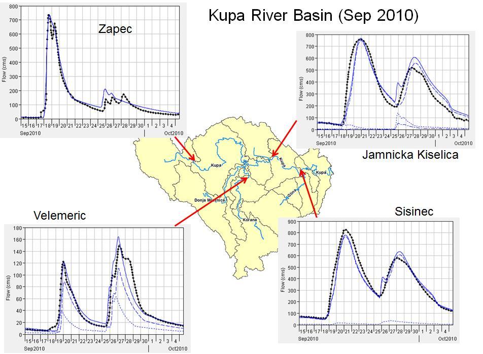
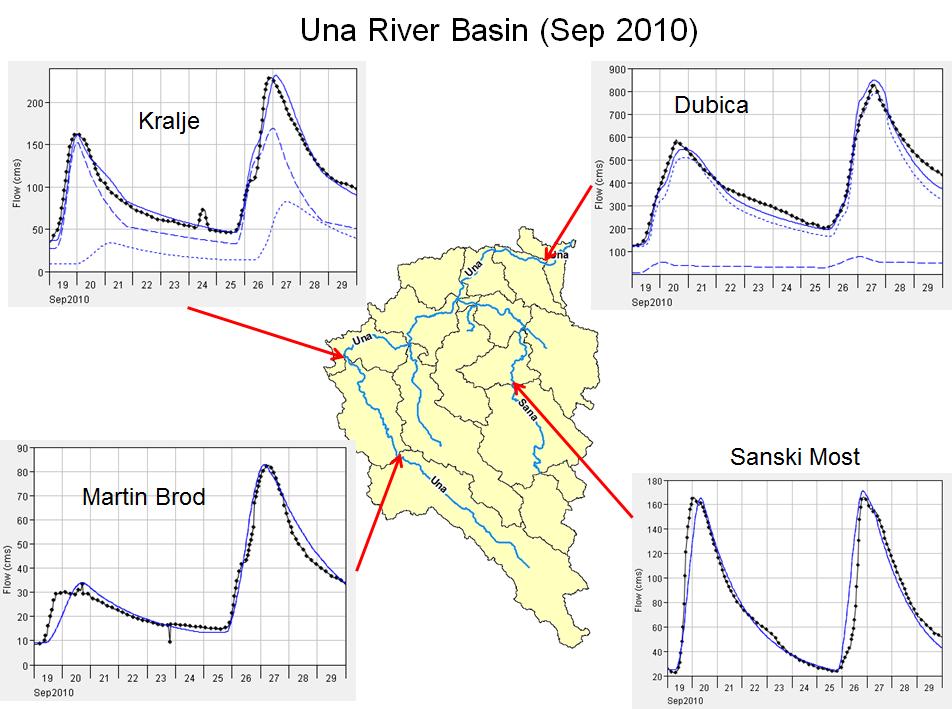
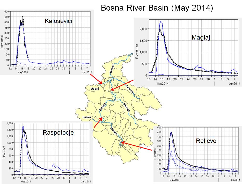
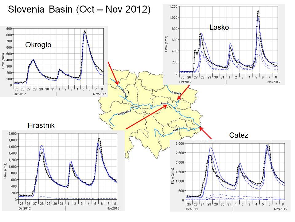
13 Calibration process Calibration results for the Sava hydrologic model for selected stations Validation results for the Sava hydrologic model for selected stations

14 Model application with future climate scenarios Metodology Baseline runoff simulated with climate parameters from climate change model for the reference period The following indicators of the hydrologic regime are considered to assess the change: mean annual runoff, defined as the long-term average flow across years in a given 30-year period mean seasonal runoff, defined as the long-term average flow in four seasons across years in a given 30-year period high annual flow, defined as the annual flow with 10% probability of exceedance in a given 30-year period low annual flow, defined as the annual flow with 90% probability of exceedance in a given 30-year period

15 Climate Change Scenarios as the input to the hydrologic model Hidrology simulations with climate change scenarios Baseline: Near future: Distant future: Ansambl 5 GCM/RCM modela za A1B IPCC/SRES scenario Climate model GCM RCM CM1 ECHAM5r3 RACMO CM2 ECHAM5r3 REMO CM3 HadCM3Q0 CLM CM4 HadCM3Q0 HadRM3Q0 CM5 ECHAM5r3 RegCM3
16 Future climate as predicted by climate models Air Temperature Scenarios Results A clear increasing trend, with little variation over the basin The average change in mean annual temperature over all meteorological stations used in the hydrologic model ranges from 0.9 to 1.8 C (median value 1.0 C) for different climate models in the near future and from 2.0 to 3.1 C (median value 2.3 C) in the distant future Different climate models predict the most pronounced increase in temperature in different seasons. For the near future, one model predicts the highest increase in summer, two in autumn and two in winter. For the distant future, one model predicts the highest increase in summer, one in both summer and autumn, and three in winter
17 Future climate as predicted by climate models Precipitation Scenarios Results Precipitation shows variable trends, with a lot of variation across the basin and across the climate models and seasons The change in mean annual precipitation is generally very small A clear increasing or decreasing trend in seasonal precipitation across the whole basin cannot be seen in all models. For the near future, two models predict a clear increasing trend in winter precipitation and a clear decreasing trend in summer precipitation. For the distant future, three models predict a clear increasing trend in winter precipitation and four models predict a clear decreasing trend in summer precipitation.

18 Future climate as predicted by climate models Scenarios for evapotranspiration (potential) The choice of potential methods was very limited since no information was available on any of the climatological parameters affecting PET (e.g. solar radiation, humidity, wind speed) except the air temperatures, neither for the past climate nor for future projections Based on temperature scenarios and the Hargreaves equation for PET PET R TD ( TC 17.8) a
19 Hydrologic simulations with future climate scenarios change in ensemble median values of mean seasonal and annual runoff; range of changes across 50 locations in the basin change in the hydrologic regime corresponds to the projected change in precipitation and temperature the most notable change in both the near and distant future is the increase of stream flow in the winter season, as the result of the increased precipitation and a significant increase in temperatures
20 Hydrologic simulations with future climate scenarios change in ensemble median values of high (Q10%) and low (Q90%) annual flow characterizing wet and dry years; range of changes across 50 locations in the basin high annual flows show greater reduction, indicating that the proportion of very wet years would decrease low annual flows are subject to a small reduction, meaning that the proportion of very dry years would slightly increase
21 Hydrologic simulations with future climate scenarios Change in ensemble median values of low flows (80% mean monthly Q)
22 Hydrologic simulations with future climate scenarios Change in ensemble median values of low flows (95% mean monthly Q)
23 Water and Climate Adaptation Plan for the Sava River Basin (WATCAP)
24 Sava hydrological model (USACE & ISRBC, 2016)


 A new model based on")


25 2 nd phase of US Support Develop and Calibrate a flood event-based hydrologic model HEC-HMS i HEC-Geo HMS Accurate Delineation Calibration and verification Improve upon the latest mainstem Sava River hydraulic model Start point existing model Preparation of new terrain model (LiDAR) A new model based on improved geometry and boundary conditions Calibration and verification 2-D capability in HEC-RAS will be implemented to simulate a levee breach scenario Develop detailed hydrologic and hydraulic modeling of the Bosna River Basin using existing models for the purpose of developing a flood forecasting platform using HEC products HEC-RTS (Real-time Simulation)
26 Main objectives To support the development of hydrological and hydraulic models of the Sava River Basin, tools that will strengthen multilateral cooperation in the basin, primarily in the area of flood protection To support activities leading to the preparation of a flood risk management plan as well as the development of the system for flood forecasting To establish the models that could be used for other purposes in future (modeling sediment transport, water quality, climate change analysis, etc.)

27 Hydrological modelling Start point existing WATCAP Model Use of HEC-HMS & HEC-GeoHMS Accurate Delineation Temporal Resolution Water Storage Components Calibration and Verification Final HEC-HMS Model contains a separate basin models for each tributary basin and mainstem reach (22 models in total)
28 Improvement of delineation 3 Phases of Delineation WATCAP Model Delineation (44 sub-basins) HEC-GeoHMS Delineation using 30m SRTM DEM with major streams burned into the DEM HEC-GeoHMS Delineation using 30m SRTM DEM with detailed stream network burned into the DEM and historical basin boundaries added to the DEM as walls 235 sub-basins Delineation will support the Sava River mainstem HEC-RAS hydraulic model
29 Model parameters used HEC methods for each component of the runoff process Runoff-volume model (loss method) Direct-runoff model (transform method) Baseflow model Channel flow model (routing) Deficit and Constant Clark Unit Hydrograph Recession Muskingum or Muskingum Cunge used HEC methods for each component of the meteorological model Precipitation Method Snowmelt Method Evapotranspiration Method Inverse Distance Squared Temperature Index Monthly Average Precipitation gages: 79; Temperature gages: 70; Discharge gages: 93 Evapotranspiration: the values computed by COWI during the WATCAP study transferred to the new subbasins Snow/Snowmelt: each subbasin is divided into elevation bands where initial snowpack parameters are set. The most important parameter is snow-water-equivalent (SWE). To determine initial SWE totals, satellite-based SWE grids are used

30 Meteorological parameters Inverse Distance Weighting Method Each precipitation gauge and subbasin is assigned location coordinates HMS determines rainfall amount for each subbasin by using any gauges within the search radius to assign an inverse distance weighted rainfall amount to each subbasin

31 Precipitation Gauges coverage
32 Precipitation Gauges coverage

33 Precipitation Gauges coverage
34 Air Temperature Gauges coverage

35 Discharge Gauges coverage
36 Water Storage Components Reservoirs (1 st Sava RBM Plan) No Country HPP name River Basin River 1 SI Moste/Završnica Sava direct Sava 2 SI Mavčiče Sava direct Sava 3 SI Medvode Sava direct Sava 4 SI Vrhovo Sava direct Sava 5 SI Boštanj Sava direct Sava 6 SI Arto-Blanca Sava direct Sava 7 SI Krško Sava direct Sava 8 HR Lešce Kupa/Kolpa Dobra 9 BA Bočac Vrbas Vrbas 10 BA Jajce I Vrbas Vrbas 11 BA Jajce II Vrbas Vrbas 12 BA Modrac Bosna Spreča 13 ME Piva Drina Drina 14 BA Višegrad Drina Drina 15 RS Bajina Bašta Drina Drina 16 RS Zvornik Drina Drina 17 RS Bistrica Drina Lim 18 RS Potpeć Drina Lim 19 RS Uvac Drina Uvac 20 RS Kokin Brod Drina Uvac Middle Sava Retention Areas
37 Calibration process
38 Next steps Improve upon the latest mainstem Sava River hydraulic model Start point existing model Preparation of new terrain model (Sava LiDAR project) A new model based on improved geometry and boundary conditions Calibration and verification 2-D capability in HEC-RAS will be implemented to simulate a levee breach scenario Sava LiDAR project To acquire high-quality digital elevation data and products and imagery needed for upgrade of hydraulic model of the Sava River: Areas Lidar based data and products Digital Orto photo (DOP) Sava River course "levee to levee with the buffer zone" from SI-HR border to Belgrade Main retention areas along the Sava River Flooded areas due to levee breach 2014 Bosutsko-Morovicka lowland forest area Cities Zagreb and Belgrade The Consultant (Fly Com, Slovenia) has contracted with the deadline end of April, 2017 for the final submission of products
39 Sava LiDAR project area
40 Geographical & Hydrological Information System of the Sava River Basin Sava GIS & Sava HIS

41 Sava GIS & Sava HIS Successfully completed objectives common platform of the ISRBC community to enable sharing and disseminating of information and knowledge about protection of the water resources and water management activities in the Sava River Basin support to the ISRBC community in sharing and disseminating of hydrologic and meteorological data, information and knowledge about the water resources in the Sava River basin enable an effective common channel for exchanging and viewing the hydrologic and meteorological data and information in emergency situations, primarily those related to flood events According to Implementing Documents for Establishment of the Sava GIS 2010, establishment of the Sava GIS is focused in following benefit areas: Modules 1. Int. River Basin Management 2. Flood Management 3. Accident Prevention and Control 4. Navigation Safety Management 5. Sediment Management Submodules Time-Series Data Management Metadata Management
42 Sava GIS & Sava HIS projects Scope of projects Service/deliverable Assessment of the current hydrological and meteorological data collection Establishment Sava GIS database (geodatabase) Establishment of Sava Geoportal for searching, disseminating, processing and visualization information to the stakeholders and public Establishment of web-based application for data and metadata management Establishment of web-based application for H&M real time data management Knowledge transfer - Workshops & Trainings Database models are created based on WFD reporting Guidance 2016 v.4.9 FD reporting Guidance 2013 ICPDR database models (Danube GIS) INSPIRE Directive and professional requirements WaterML 2.0 part 1: Timeseries model implementation MODULES for: River Basin Management Flood Management MODULE for: HM Time-Series Data Management


43 SavaGIS products SavaGIS Geoportal Public users Overview of public spatial data Viewing attributes and features Filtering by attributes or spatial data Exporting areas of map to PDF or PNG format Registered users web application for data management Data and metadata upload Data and metadata download FGDB XLS XML WFS of GML format Harvesting Manually Data management Access to data from SavaGIS system via WMS/WFS services: Spatial formats SHAPE file GeoJSON file KML file GML2 file WFS & WMS services Attribute formats CSV XLS MSAccess2010 DBF XML WATER ML 2.0 service Metadata catalogue


44 Time-series HM data management within Sava GIS Concept CUAHSI Consortium of Universities for the Advancement of Hydrologic Science, Inc. A consortium representing 125 US universities 1. Standards WaterML language for describing water data WaterML location variable time series 2. Services Catalog of water data sources web services Metadata Catalog 3. End user application Free software for data access HydroDesktop Web Geoportal Real-time WIS WMO Information System
")
 Daily Daily (Total) Daily real-time data exchange http://savahis.")
45 Sava HIS products historical (processed) data exchange Parameter Water Stage River Discharge Water Temperature Suspended Sediment Discharge Groundwater Level Ice Condition Relative Humidity Wind (Speed and Direction) Snow Depth Evaporation Solar Radiation Sunshine Atmospheric Pressure Temporal Resolution (Statistic) Daily (Mean) Daily (Mean) Daily (Mean) Daily (Mean) Daily; Every 5/10th Day Daily Daily Daily Daily Daily (Total) Daily Daily (Total) Daily real-time data exchange Parameter Precipitation Air Temperature Water Stage River Discharge Water Temperature Temporal Resolution Daily (Total) Current Current Current Current

46 Contact information International Sava River Basin Commission Kneza Branimira Zagreb Croatia
Ongoing and planned activities of the Sava Commission related to the scope of EUSDR PA5
 Ongoing and planned activities of the Sava Commission related to the scope of EUSDR PA5 11 TH PA5 STEERING GROUP MEETING 27 January 2017, Budapest Mirza Sarač, International Sava River Basin Commission
Sava Commission Activities. KICK-OFF MEETING DANTE, February 17, 2017, Budapest
 Sava Commission Activities KICK-OFF MEETING DANTE, February 17, 2017, Budapest 1 Establishment of the ISRBC 2 Decay of SFRY a challenge to WRM in the Sava river basin Sava river used to be the biggest
National and Regional Activities, Needs and Expectations
 National and Regional Activities, Needs and Expectations The perspective from the International Sava River Basin Commission International collaboration in the forecasting of river flows within the Sava
Jasna Plavsic. WATER-FOOD-ENERGY-ECOSYSTEMS NEXUS ASSESSMENT IN THE SAVA RIVER BASIN Zagreb, 6 March 2014
 WATER-FOOD-ENERGY-ECOSYSTEMS NEXUS ASSESSMENT IN Zagreb, 6 March 214 Water and Climate Adaptation Plan (WATCAP) for the Sava River Basin: Climate Change Predictions for the Sava River Basin Jasna Plavsic
International Sava River Basin Commission - An example of EU/non EU country cooperation in water management
 International Sava River Basin Commission - An example of EU/non EU country cooperation in water management Improvement and co-operation possibilities in the water sector with non-eu countries Ulm, 29
Regional Cooperation on Flood Management in the Sava River Basin
 Regional Cooperation on Flood Management in the Sava River Basin Flood Risk Management Plans: international experiences by comparison Mirza Sarač ISRBC Secretariat Content Introduction Sava River Basin
Sava Commission Activities. DANUBE SKILLS KICK OFF EVENT, February 21, 2017, Bucharest
 Sava Commission Activities DANUBE SKILLS KICK OFF EVENT, February 21, 2017, Bucharest 1 Establishment of the ISRBC 2 Decay of SFRY a challenge to WRM in the Sava river basin Sava river used to be the biggest
Overview. Sava River Basin. Sava River Basin. Sava River Basin
 Overview Introduction on the Framework Agreement on the a basis for sustainable development of the region Framework Agreement on the (FASRB) and the International Commission (ISRBC) Approach to Sustainable
Framework Agreement on the Sava River Basin and its implementation
 Framework Agreement on the Sava River Basin and its implementation Dejan Komatina, Ph.D. Civ. Eng., Secretary, ISRBC Samo Grošelj, Deputy Secretary Overview Introduction on the Sava river basin Establishment
Terms of Reference (ToR) for a Short-Term assignment
 for a Short-Term assignment") Terms of Reference (ToR) for a Short-Term assignment Technical assistance requested Expert for climate change mitigation and adaptation Project Title Outline of the Climate Adaptation Strategy and basin-wide
Terms of Reference (ToR) for a Short-Term assignment Technical assistance requested Expert for climate change mitigation and adaptation Project Title Outline of the Climate Adaptation Strategy and basin-wide
International Sava River Basin Commission
 International Sava River Basin Commission Pilot project on climate change: Building the link between the Flood Risk Management planning and climate change assessment in the Sava River Basin climate change
International Sava River Basin Commission
 International Sava River Basin Commission Pilot project on climate change: Building the link between the Flood Risk Management planning and climate change assessment in the Sava River Basin - climate change
PROGRAM FOR DEVELOPMENT OF FLOOD RISK MANAGEMENT PLAN IN THE SAVA RIVER BASIN. Draft 8
 PROGRAM FOR DEVELOPMENT OF FLOOD RISK MANAGEMENT PLAN IN THE SAVA RIVER BASIN Draft 8 May 2016 Date Document revision history Document author/ reviser 17 April 2014 Draft 1 sent to as document for 24 th
ACTION PLAN FOR THE PERIOD concerning the STRATEGY ON IMPLEMENTATION OF THE FRAMEWORK AGREEMENT ON THE SAVA RIVER BASIN
 Doc. 1S-26-O-11-5/1-2 ACTION PLAN FOR THE PERIOD 2011-2015 concerning the STRATEGY ON IMPLEMENTATION OF THE FRAMEWORK AGREEMENT ON THE SAVA RIVER BASIN April 2011 Table of Contents INTRODUCTION... 5 1.
12th Sava PEG FP Meeting REPORT 1 Zagreb, Croatia October 20-21, 2009
 Ref. No.: 30916/32 Zagreb, October 21, 2009 12th Sava PEG FP Meeting REPORT 1 Zagreb, Croatia October 2021, 2009 1 Final version reviewed and accepted by the PEG FP Agenda of the Meeting 1. Opening of
REPORT from the 47 th Session of the International Sava River Basin Commission
 Doc. No: 1S-47-M-17-1/1-3 REPORT from the 47 th Session of the International Sava River Basin Commission Zagreb, 10-11 October 2017 Venue: Premises of the International Sava River Basin Commission, Kneza
Enhancing hydrological data management and exchange procedures
 Enhancing hydrological data management and exchange procedures The Sava River Hydraulic Model Dr Mark R Jourdan, PE Research Hydraulic Engineer U.S. Army Engineer Research and Development Center Vicksburg,
CO-OPERATION IN DANUBE RIVER BASIN - THE ROLE OF SHMI SLOVENSKÝ HYDROMETEOROLOGICKÝ ÚSTAV
 CO-OPERATION IN DANUBE RIVER BASIN - THE ROLE OF SHMI WMO RAVI Hydrological Forum 2016 Oslo, 1 Danube, the 2nd longest in Europe. 2857 km Flows across 10 European states River basin - 817 000 km2 1/11
REPORT on implementation of the FRAMEWORK AGREEMENT ON THE SAVA RIVER BASIN and work of International Sava River Basin Commission in the period April
 REPORT on implementation of the FRAMEWORK AGREEMENT ON THE SAVA RIVER BASIN and work of International Sava River Basin Commission in the period April 01, 2016 March 31, 2018 7 th Meeting of the Parties
Presentation from 2015 World Water Week in Stockholm. The authors, all rights reserved. SIWI siwi.org
 Presentation from 2015 World Water Week in Stockholm www.worldwaterweek.org The authors, all rights reserved SIWI siwi.org WORLD WATER WEEK Stockholm, 23 th August 2015 Co-operative water governance: catalyst
ACTIVITIES ON FLOOD RISK MANAGEMENT AND CLIMATE CHANGE ADAPTATION IN THE SAVA RIVER BASIN
 ACTIVITIES ON FLOOD RISK MANAGEMENT AND CLIMATE CHANGE ADAPTATION IN THE SAVA RIVER BASIN Workshop on WATER-FOOD-ENERGY-ECOSYSTEMS NEXUS ASSESSMENT IN THE SAVA RIVER BASIN 4-6 March 2014, Zagreb Vasiljka
Towards practical Guidance for Sustainable Sediment Management using the Sava River as a showcase
 UNIVERSITY OF ZAGREB FACULTY OF CIVIL ENGINEERING WATER RESEARCH DEPARTMENT Towards practical Guidance for Sustainable Sediment Management using the Sava River as a showcase Damir Bekić, Ph.D., M.Sc.,
"Transboundary coordination according to the FD Directive in the shared river basins of Greece
 Workshop on Transboundary Issues Budapest March 31st April 1st "Transboundary coordination according to the FD Directive in the shared river basins of Greece Katerina Triantafyllou, ECOS Consulting S.A.
28 th Meeting of the Permanent Expert Group for Flood Protection REPORT FROM THE MEETING Zagreb, January 2016
 Ref. No.: 3-16-1/3-2 Zagreb, 27 January 2016 28 th Meeting of the Permanent Epert Group for Flood Protection REPORT FROM THE MEETING Zagreb, 26-27 January 2016 Venue: Premises of the International Sava
We are IntechOpen, the world s leading publisher of Open Access books Built by scientists, for scientists. International authors and editors
 We are IntechOpen, the world s leading publisher of Open Access books Built by scientists, for scientists 4,000 116,000 120M Open access books available International authors and editors Downloads Our
FLOOD RISK MANAGEMENT PLAN FOR THE SAVA RIVER BASIN DRAFT
 Flood Risk Management Plan for the Sava River Basin FLOOD RISK MANAGEMENT PLAN FOR THE SAVA RIVER BASIN DRAFT OCTOBER 2018 Version 2.0 FLOOD RISK MANAGEMENT PLAN FOR THE SAVA RIVER BASIN Document title:
Management of a Large The Danube. Mr. Mitja Bricelj ICPDR President Perth,13 October 2010
 Management of a Large International ti River Basin: The Danube Mr. Mitja Bricelj ICPDR President Perth,13 October 2010 From the Black Forest From the Black Forest to the Black Sea Human activities damaged
IPA Project Building Resilience to Disasters in Western Balkans and Turkey. Enhancing hydrological data management and exchange procedures
 IPA Project Building Resilience to Disasters in Western Balkans and Turkey Enhancing hydrological data management and exchange procedures Banja Luka, 15-16 April 2014 MEETING REPORT 1. Introduction In
Implementation of the Water Convention, including its complementary role to the EU Water Framework Directive
 Implementation of the Water Convention, including its complementary role to the EU Water Framework Directive Experience of Serbia Dragana Milovanović Ministry of Agriculture, Forestry and Water Management
Waukegan & Calumet Rivers. All Hands Meeting
 Waukegan & Calumet Rivers 516(e) Update All Hands Meeting David F. Bucaro, P.E. Chief, Economic Formulation & Analysis Section, Planning Branch May 18 th, 2011 Kensington Court Ann Arbor, MI 1 2 Waukegan
Public Seminar 30 October 2018, Lisbon. Water sector in B&H
 Public Seminar 30 October 2018, Lisbon Water sector in B&H Ministry of Foreign Trade and Economic Relations www.mvteo.gov.ba Boško Kenjić, Head of Department Tel: +387 33 262 155 E-mail: bosko.kenjic@mvteo.gov.ba
Ref. No.: /2-3 Zagreb, 18 June th PEG RBM Meeting REPORT Zagreb, Croatia June 2015
 Ref. No.: 3-15-6/2-3 Zagreb, 18 June 2015 29 th PEG RBM Meeting REPORT Zagreb, Croatia 17-18 June 2015 Agenda of the meeting 1. Opening of the meeting 1.1. Welcome and opening remarks 1.2. Adoption of
Project Fiche MASTER PLAN FOR DEVELOPMENT OF THE NAUTICAL TOURISM IN THE SAVA RIVER BASIN
 Project Fiche MASTER PLAN FOR DEVELOPMENT OF THE NAUTICAL TOURISM IN THE SAVA RIVER BASIN 1. Basic information 1.1 Title: Master plan 1.2 Location: Sava River Basin which covers Bosnia and Herzegovina,
Hydrological study for the operation of Aposelemis reservoir Extended abstract
 Hydrological study for the operation of Aposelemis Extended abstract Scope and contents of the study The scope of the study was the analytic and systematic approach of the Aposelemis operation, based on
2014 floods in Serbia
 16 th Meeting of WGF, Rim, 9-10 October 2014 2014 floods in Serbia Radovanka Pavlović Ministry of Agriculture and Environmental Protection Republic Water Direcrorate, Belgrade, Serbia Specific cyclone
The Danube Experience
 The Danube Experience Dealing with Hydromorphological Issues the Danube Experience Philip Weller Executive Secretary, ICPDR Danube River Basin- Overview The Danube River Basin is the most international
Doc. No. 1S-26-O-11-4/2-2 STRATEGY ON IMPLEMENTATION OF THE FRAMEWORK AGREEMENT ON THE SAVA RIVER BASIN
 Doc. No. 1S-26-O-11-4/2-2 STRATEGY ON IMPLEMENTATION OF THE FRAMEWORK AGREEMENT ON THE SAVA RIVER BASIN April 2011 Table of Contents 1. Introduction... 5 2. Framework for transboundary cooperation in
14 th Sava PEG RBM Meeting REPORT 1 Zagreb, Croatia September 29 th
 Zagreb, September 29, 2009 Ref.Nr.: 3-09-15/3-2 14 th Sava PEG RBM Meeting REPORT 1 Zagreb, Croatia September 29 th 1 Final PEG version Agenda of the Meeting 1. Opening of the meeting Welcome address Adoption
Implementation of WFD in Serbia and Montenegro
 Ministry of Agriculture, Forestry and Water Management Directorate for Water Implementation of WFD in Serbia and Montenegro Nikola Marjanovic, PhD Civ. Eng. SERBIA AND MONTENEGRO SERBIA Area: 88.361 km
14 th PEG GIS Meeting Report
 Ref. No.: 3-16-7/3-2 Zagreb, 31 October 2016 14 th PEG GIS Meeting Report Belgrade, 06 October 2016 Venue: Floating boat of PWMC Srbijavode, Belgrade, Republic of Serbia 1 Table of Contents I. ATTENDANCE...
Project Data Sheet BASIC PROJECT DATA. Rehabilitation and Development of Transport and Navigation on the Sava River Waterway. Full project title:
 BASIC PROJECT DATA Full project title: Short project title: (acronym) Rehabilitation and Development of Transport and Navigation on the Sava River Waterway Project logo: Project website: www.savacommission.org
Development of a MIKE11 Model of the Danube, Tisa and Sava Rivers in Serbia
 Development of a MIKE11 Model of the Danube, Tisa and Sava Rivers in Serbia Vasiljka KOLAROV*, Marina BABIĆ MLADENOVIĆ*, Zoran KNEŽEVIĆ*, Martin MIŠIK** * Jaroslav Černi Institute, Department for River
PCN Annex: GEF Data Sheet
 PCN Annex: GEF Data Sheet PROJECT IDENTIFICATION Project Title: West Balkans Drina River Basin Management Country(ies): Bosnia-Herzegovina, Serbia, GEF Project ID: 7 Montenegro GEF (ies): World Bank GEF
Outline. The main objectives. The main objectives. Distribution of stable isotopes in the Sava River in Serbia
 Distribution of stable isotopes in the Sava River in Serbia N. MILJEVIĆ 1, D. GOLOBOČANIN 1, M. NADEŽDI DIĆ, N. OGRINC 3 1 Vinča a Institute of Nuclear Sciences, POB 5, 11001 Belgrade, Serbia Republic
Lessons Learned from the Floods this May
 Building Resiliance to Disasters in Western Balkans and Turkey Design a Regional Multi-Hazard EWS Composed of harmonized National EWS econd Meeting of the Design Team 9 11 September 2014, Durrës, Albania
Competence Requirements for eronautical eteorological ersonnel
 WMO-CGMS Virtual Laboratory For Education and Training in Satellite Meteorology Competence Requirements for eronautical eteorological ersonnel 2013 and beyond Overview Part One Background and Terminology
Scientific Support to the EU Strategy for the Danube Region and the Danube Water Nexus project
 Scientific Support to the EU Strategy for the Danube Region and the Danube Water Nexus project Giovanni Bidoglio Joint Research Centre European Commission UNECE and ISRBC Sava River Basin Workshop Zagreb,
Danube River Basin District
 Ministry of Agriculture, Forestry and Water Management June 18 th, 2004 Danube River Basin District Part B - Report 2003 CROATIA Information required according to Art. 3 (8) and Annex I of the EU Water
Transboundary River Management in the Danube Basin
 Southern Illinois University Carbondale OpenSIUC Key Note Presentation World River Day 2011 11-2011 Transboundary River Management in the Danube Basin Philip Weller International Commission for the Protection
ICPDR FP-EG project overview
 ICPDR FP-EG project overview 9 th Steering Group meeting of PA5 of the EUSDR Management of Environmental Risks KÁROLY GOMBÁS CHAIRMAN FLOOD PROTECTION EXPERT GROUP (FP-EG) INTERNATONAL COMISSION OF THE
Danube River Basin District
 Danube River District Part B - Report 2003 ROMANIA Information required according to Art. 3 (8) and Annex I of the EU Water Framework Directive Reporting deadline: June 22, 2004 Prepared by National Administration
Rehabilitation and development of navigation on the Sava river
 Rehabilitation and development of navigation on the Sava river 3rd Joint Statement Implementation Meeting, Vienna, April 5-6, 2011 Background of the project Recognized as a priority project in the framework
THE NORTH ATLANTIC OSCILLATION (NAO) AND THE WATER TEMPERATURE OF THE SAVA RIVER IN SERBIA
 AND THE WATER TEMPERATURE OF THE SAVA RIVER IN SERBIA") www.ebscohost.com www.gi.sanu.ac.rs, www.doiserbia.nb.rs, J. Geogr. Inst. Cvijic. 67(2) (135 144) Original scientific paper UDC:911.2:551.482(497.11) DOI: https://doi.org/10.2298/ijgi1702135m THE NORTH
www.ebscohost.com www.gi.sanu.ac.rs, www.doiserbia.nb.rs, J. Geogr. Inst. Cvijic. 67(2) (135 144) Original scientific paper UDC:911.2:551.482(497.11) DOI: https://doi.org/10.2298/ijgi1702135m THE NORTH
FLOW REDUCTION IMPACTS ALONG RIVER NILE IN EGYPT
 FLOW REDUCTION IMPACTS ALONG RIVER NILE IN EGYPT Sherine S. Ismail Prof., Head of Lake Nasser studies department, Nile Research Institute, E-mail:sherine_shawky@yahoo.com ABSTRACT Nile water discharges
Danube River Basin. a source for transboundary cooperation. Exploring the Results and Potential for Transboundary Water Management Cooperation
 Danube River Basin a source for transboundary cooperation Exploring the Results and Potential for Transboundary Water Management Cooperation Philip Weller ICPDR, Executive Secretary Joint Meeting EUWI
Active Geodetic Network of Serbia
 Active Geodetic Network of Serbia Oleg ODALOVIC and Ivan ALEKSIC, Serbia Key words: GPS, AGROS, RINEX, RTCM SUMMARY In June 2003 the Republic Geodetic Authority (RGZ) has started the realization of the
INTERNATIONAL SAVA RIVER BASIN COMMISSION. Sava River Basin Analysis Report
 2009 INTERNATIONAL SAVA RIVER BASIN COMMISSION Sava River Basin Analysis Report Zagreb September 2009 Prepared by International Sava River Basin Commission International Sava River Basin Commission (ISRBC)
The Timok River Basin in Serbia
 The Timok River Basin in Serbia UNECE Workshop on Integrated Transboundary Water Resources Management in SEE, Sarajevo, 18-20 May, 2009 Dragana Ninković, Dipl.-Ing. Dušan Dobričić, Dipl.-Ing. Content 1.
Sava River Basin Analysis Summary
 External Action of the European Union: Support to the International Sava River Basin Commission in preparation and implementation of the Sava River Basin Management Plan Sava River Basin Analysis Summary
ACTIVITIES RELATED TO THE WFD IMPLEMENTATION IN SERBIA AND MONTENEGRO WB, HMWB AND AWB - PRELIMINARY IDENTIFICATION
 ACTIVITIES RELATED TO THE WFD IMPLEMENTATION IN SERBIA AND MONTENEGRO WB, HMWB AND AWB - PRELIMINARY IDENTIFICATION Slobodan Petković, Marina Babic Mladenovic,, Bruno Jurak and Dragana Ninkovic Institute
Development of the Danube River Basin District Management Plan
 DRAFT-8 DOC-101 23-Nov-2005 Development of the Danube River Basin District Management Plan - Strategy for coordination in a large international river basin River Basin Management Expert Group Prepared
DriDanube project overview
 DriDanube project overview Drought risk in the Danube Region Andreja Sušnik, Jana Pangrácová Slovenian Environment Agency, GWP CEE 13th PA4 SCG Meeting, Bratislava, 25-26 April 2017 DriDanube Drought Risk
Regional implementation of Electronic Terrain and Obstacle data (e-tod) (Presented by Jeppesen)
 (Presented by Jeppesen)") International Civil Aviation Organization SAM/IG/13-WP/39 South American Regional Office 5/04/14 Thirteenth Workshop/Meeting of the SAM Implementation Group English only (SAM/IG/13) - Regional Project
International Civil Aviation Organization SAM/IG/13-WP/39 South American Regional Office 5/04/14 Thirteenth Workshop/Meeting of the SAM Implementation Group English only (SAM/IG/13) - Regional Project
Common Principles and Technical Requirements for Pan-European River Information Services (RIS)
") Common Principles and Technical Requirements for Pan-European River Information Services (RIS) Joint Presentation of the and the Geneva, October 2008 Content Inland Waterways of the Region Legal Background
Common Principles and Technical Requirements for Pan-European River Information Services (RIS) Joint Presentation of the and the Geneva, October 2008 Content Inland Waterways of the Region Legal Background
Regional Seminar/Workshop on CMA and SAST
 International Civil Aviation Organization Regional Seminar/Workshop on CMA and SAST September 2011 ICAO Electronic Safety Tools Module 7 1 Contents 7.1 Introduction 7.2 ICAO online safety framework 7.3
ICAO GANP Requirements and Evolution
 ICAO GANP Requirements and Evolution Olga de Frutos Brussels/October 2017 Flight Plan Context Current GANP Role in ICAO Next edition: AMET, DATM, FICE and SWIM The future ATM system To achieve an interoperable
Transboundary Water Management in Republic of Macedonia
 12th International Conference EUROPE-INBO 2014 12-15 November 2014, Bucharest, Romania. Transboundary Water Management in Republic of Macedonia Ylber Mirta Head of Department for Waters ymirta@gmail.com
The Role of Glaciers in the Hydrologic Regime of the Nepal Himalaya. Donald Alford Richard Armstrong NSIDC Adina Racoviteanu NSIDC
 The Role of Glaciers in the Hydrologic Regime of the Nepal Himalaya Donald Alford Richard Armstrong NSIDC Adina Racoviteanu NSIDC Outline of the talk Study area and data bases Area altitude distributed
Sub-Basin Level Flood Action Plan - Sava River Basin
 in cooperation with the Sub-Basin Level Flood Action Plan - Sava River Basin 50 0'0"N Hamburg Bremen Berlin Essen Leipzig Koln Dresden Bonn Frankfurt am Main Wroclaw Warsaw Lodz Krakow Lvov Minsk Dnieper
HYDROELECTRIC POWER PLANTS ON THE LOWER SAVA RIVER
 HYDROELECTRIC POWER PLANTS ON THE LOWER SAVA RIVER The construction of a chain of hydroelectric power plants on the lower course of the Sava River is a multi-purpose project that makes a significant contribution
Danube River Basin District
 Danube River Basin District Part B National Report BULGARIA Information required according to Art. 3 (8) and Annex I of the EU Water Framework Directive prepared by Ministry of Environment and Water 2
Optimizing trajectories over the 4DWeatherCube
 Optimizing trajectories over the 4DWeatherCube Detailed Proposal - SES Awards 2016 Airbus Defence and Space : dirk.schindler@airbus.com Luciad : robin.houtmeyers@luciad.com Eumetnet : kamel.rebai@meteo.fr
REGIONAL STRATEGY FOR SUSTAINABLE HYDROPOWER IN THE WESTERN BALKANS. Approach and Methodology
 This project is funded by the European Union REGIONAL STRATEGY FOR SUSTAINABLE HYDROPOWER IN THE WESTERN BALKANS Approach and Methodology Martyn Osborn - Key Expert, Energy Marko Kosir - Senior Project
Danube River Basin District
 Danube River Basin District Part A - Roof report Information required according to Art. 3 (8) and Annex I of the EU Water Framework Directive Reporting deadline: June 22, 2004 Prepared by: International
The European Union Strategy for the Danube Region: climate and disaster risk reduction
 The European Union Strategy for the Danube Region: climate and disaster risk reduction Károly Gombás 16.11.2017, Budapest Project co-funded by European Union funds (ERDF) National and transboundary issues
REPUBLIC HYDROMETEOROLOGICAL SERVICE OF SERBIA. MEDARE 3 rd Expert Group Meeting Istanbul, Turkey September 2012
 REPUBLIC HYDROMETEOROLOGICAL SERVICE OF SERBIA MEDARE 3 rd Expert Group Meeting Istanbul, Turkey 27 28 September 2012 BRIEF HISTORY Meteorological and hydrological activity in the territory of Serbia has
SESAR Active ECAC INF07 REG ASP MIL APO USE INT IND NM
 SESAR Active ECAC INF07 REG ASP MIL APO USE INT IND NM Subject matter and scope * The extension of the applicability area to non-eu ECAC States that have not signed an aviation agreement with EU, as well
Key Tasks and Preliminary Findings
 This project is funded by the European Union REGIONAL HYDRO MASTER-PLAN (Hydropower Development Study in the Western Balkans) Key Tasks and Preliminary Findings Martyn Osborn - Key Expert, Energy Marko
REPORT from the 11 th Special Session of the International Sava River Basin Commission
 Doc. No: 1S-11-M-08-1/2-2 REPORT from the 11 th Special Session of the International Sava River Basin Commission Held on July 15-16, 2008 and continued on October 14, 2008 Zagreb I Attendance The International
CITY OF LYNDEN STORMWATER MANAGEMENT PROGRAM REPORT MARCH 1, 2016
 CITY OF LYNDEN STORMWATER MANAGEMENT PROGRAM 2015 WATER QUALITY MONITORING REPORT CITY OF LYNDEN 300 4 TH STREET LYNDEN, WASHINGTON 98264 PHONE (360) 354-3446 MARCH 1, 2016 This document serves as an attachment
DriDanube. Drought Risk in the Danube Region. Department of Geodesy and Geoinformation (GEO) Vienna University of Technology (TU Wien)
 Vienna University of Technology (TU Wien)") DriDanube Drought Risk in the Danube Region Department of Geodesy and Geoinformation (GEO) Vienna University of Technology (TU Wien) Vienna, 4 April 2018 DriDanube Drought Risk in the Danube Region Project
DriDanube Drought Risk in the Danube Region Department of Geodesy and Geoinformation (GEO) Vienna University of Technology (TU Wien) Vienna, 4 April 2018 DriDanube Drought Risk in the Danube Region Project
Glacial lakes as sentinels of climate change in Central Himalaya, Nepal
 Glacial lakes as sentinels of climate change in Central Himalaya, Nepal Sudeep Thakuri 1,2,3, Franco Salerno 1,3, Claudio Smiraglia 2,3, Carlo D Agata 2,3, Gaetano Viviano 1,3, Emanuela C. Manfredi 1,3,
Stability Pact for SEE. Working Table II. Sava River Basin Initiative
 Stability Pact for SEE Working Table II Sava River Basin Initiative Background Prior to disintegration of former Yugoslavia, the Sava was a river basin of national interest Now, it belongs to four countries:
POLICY ON THE EXCHANGE OF HYDROLOGICAL AND METEOROLOGICAL DATA AND INFORMATION IN THE SAVA RIVER BASIN
 POLICY ON THE EXCHANGE OF HYDROLOGICAL AND METEOROLOGICAL DATA AND INFORMATION IN THE SAVA RIVER BASIN Policy on the Exchange of Hydrological and Meteorological Data and Information in the Sava River Basin
SIMULATION OF BOSNIA AND HERZEGOVINA AIRSPACE
 SIMULATION OF BOSNIA AND HERZEGOVINA AIRSPACE SECTORIZATION AND ITS INFLUENCE ON FAB CE Valentina Barta, student Department of Aeronautics, Faculty of Transport and Traffic Sciences, University of Zagreb,
THE REPUBLIC OF SERBIA MINISTRY OF ENVIRONMENTAL PROTECTION DEVELOPMENT OF THE ECOLOGICAL NETWORK IN SERBIA
 THE REPUBLIC OF SERBIA MINISTRY OF ENVIRONMENTAL PROTECTION DEVELOPMENT OF THE ECOLOGICAL NETWORK IN SERBIA Establishment of the Ecological Network in Serbia As a first step towards establishment of the
Hydrology Input for West Souris River IWMP
 Hydrology Input for West Souris River IWMP Prepared by: Mark Lee Manitoba Water Stewardship 1 1 1 Overall view of: drainage area watershed characteristics gauging stations meteorological stations Runoff
Environmental Impact Assessment in Chile, its application in the case of glaciers. Carlos Salazar Hydro21 Consultores Ltda.
 Environmental Impact Assessment in Chile, its application in the case of glaciers Carlos Salazar Hydro21 Consultores Ltda. carlos.salazar@hydro21.cl Introduction Changes in the environmental law in Chile
EU Strategy for the Danube Region framework for development of inland navigation
 EU Strategy for the Danube Region framework for development of inland navigation Belgrade, 6 March 2013 International Conference Sava River A Transport corridor & tourist destination Markus Simoner, via
Land Figures & Spatial Data Infrastructure in KOSOVO
 Land Figures & Spatial Data Infrastructure in KOSOVO Idriz SHALA idriz.shala@gmail.com GIS -expert Afrim SHARKU afrim.sharku@gmail.com Land Management - Expert Kick-off meeting of the Regional Expert Advisory
ANNEX IV. Heavily Modified Surface Water Bodies in Serbia and Montenegro
 ANNEX IV Heavily Modified Surface Water Bodies in Serbia and Montenegro Annex IV Heavily Modified Surface Water Bodies in Serbia and Montenegro 1 (1) HMWB Danube Location location Code/abbreviation of
MANAGING FRESHWATER INFLOWS TO ESTUARIES
 MANAGING FRESHWATER INFLOWS TO ESTUARIES Yuna River Hydrologic Characterization A. Warner Warner, A. (2005). Yuna River Hydrologic Characterization. University Park, Pennsylvania: The Nature Conservancy.
Managing environmental risks in the Danube Region
 Environmental Risks Managing environmental risks in the Danube Region www.danubeenvironmentalrisks.eu INTRODUCTION The Danube Region represents one fifth of the European Union s total area and is home
Platform and Products
 International Partnership Space Programme Earth Observation for the Preservation of Ecological Bacalar Corridor Platform and Products Terri Freemantle, Raffaella Guida, Paula Marti, Pasquale Iervolino
Using of space technologies for glacierand snow- related hazards studies
 United Nations / Germany international conference on International Cooperation Towards Low-Emission and Resilient Societies Using of space technologies for glacierand snow- related hazards studies Bonn,
Connecting Sava River. Tihomir L. Divjak
 Connecting Sava River Tihomir L. Divjak Baseline Sava River Basin is an unstable hydrological system Smart and sustainable development of Sava River Basin must be provided Definitions are given in the
HYDRAULIC DESIGN OF THE TOURISTIC BERTHING IN ASWAN CITY
 HYDRAULIC DESIGN OF THE TOURISTIC BERTHING IN ASWAN CITY Dr. Hossam El-Sersawy Researcher, Nile Research Institute (NRI), National Water Research Center (NWRC), Egypt E-mail: h_sersawy@hotmail.com Dr.
Watershed Runoff Analysis
 CREATING SOLUTIONS FOR A CHANGING WORLD Watershed Runoff Analysis April 18, 2017 John Melack, UCSB Ed Beighley & Dongmei Feng, Northeastern University Study Workflow Civil and Environmental Engineering
WWF MedPO Dinaric Arc Parks - Team meeting -
 "Promoting regional cooperation in the Western Balkans through improved management of natural resources" Dinaric Arc Parks - Team meeting - Michel Roggo / WWF-Canon Andrea Štefan WWF Belgrade, 04 June
The UNDP/GEF Danube Regional Project
 1 The UNDP/GEF Danube Regional Project Pilot River Basin Management Plan for the Sava River Sub-Basin Andy Garner Environmental Specialist Sava Initiative WG Meeting September 17-18, 2002 GEF Black Sea