Portugal designates five varied Ramsar sites
|
|
|
- Steven Caldwell
- 6 years ago
- Views:
Transcription

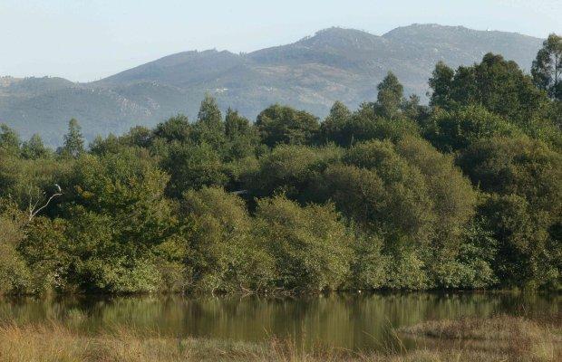
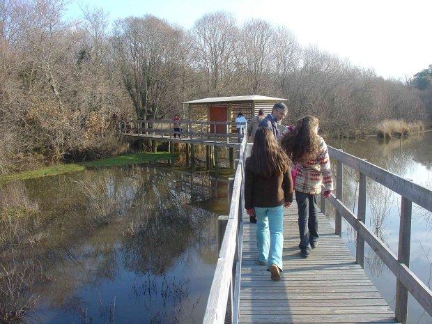
1 Portugal designates five varied Ramsar sites 11 mai 2006 Portugal Interesting new Ramsar sites in Portugal The Secretariat is very pleased to announce that the government of Portugal has designated five new Wetlands of International Importance, effective 2 December They are: Bertiandos and S. Pedro of Arcos Lagoons (346 hectares, 41 45'N 'W), a complex of permanent and temporary freshwater lakes on the right bank of the Lima River in the north of the country; Estrela Mountain upper Plateau and upper Zêzere River (5,075 ha, 40 21'N 'W), the upper reaches and plateau region of Portugal's highest mountain (1993m); 'Fajãs' of Caldeira and Cubres Lagoons (87 ha, 38º38'N 027º57'W), two small coastal lagoon systems formed by landslide processes off steep coastal cliffs on S. Jorge Island in the Azores Autonomic Region; Mira Minde Polje and related Springs (662 ha, 39 29'N 'W), an important, flat karstic depression and associated subterranean hydrological system, springs, and caves; and Mondego Estuary (1,518 ha, 40º08'N 008º50'W), the estuary of the largest river that is wholly within Portugal. Portugal now has 17 Ramsar sites covering a surface area of 73,784 hectares, and the Convention as a whole has 1,601 Ramsar sites, covering 134,701,820 hectares. Brief site descriptions, prepared from the Ramsar Information Sheets with the help of Dorothea August, and a number of photographs of the new sites, can be found below. Bertiandos and S. Pedro of Arcos Lagoons. 02/12/05; Região Norte; 346 ha; 41 45'N 'W. Natura 2000, Protected Landscape, partly National Ecological Reserve. A complex of permanent and temporary freshwater lakes on the right bank of the Lima River, hosting a broad range of 500 inventoried floristic and many fauna species. It is an important habitat for aquatic bird species for breeding, resting and migrating species, supporting amongst others Gallinula choropus, Alcedo athis and Ardea purpurea or Caprimulgus europaeus. It also supports two migrating fish species, Anguilla anguilla and Petromyzom marinus, that use the Estorãos River during the larval age and as an ecological corridor for the spawning sites located upstream. The strong relations between the area and the local population are part its cultural value, together with environmental education, leisure activities and outdoor recreation. Some of these activities may affect the ecological features, especially the agricultural developments of corn and rye-grass succession, with increasing abandonment of the pastures areas, and the intensification of agricultural production, including the spread of exotic species plantation (Eucalyptus globulus). Further impacts on the species composition and spread of some exotic species are caused by frequent forest fires and the cleaning of drainage trenches in the flooded space. Ramsar site no
2
 as well as the Candeeira valley and parts of the Zêzere river valley, which is described as its own")

3 Estrela Mountain upper Plateau and upper Zêzere River. 02/12/05; Região Centro; 5,075 ha; 40 21'N 'W. Biogenetic Reserve, Natural Park, Natura 2000 site. Comprises the upper mountain and plateau (up to 1,993m, the highest point in Portugal) as well as the Candeeira valley and parts of the Zêzere river valley, which is described as its own biogeographical sector, the "Estrellense", a transition zone between the temperate and mediterranean macrobioclimate. Due to high precipitation, there are various natural lakes, ponds, swamps, bogs, springs, brooks and rivers as well as mat-grass swards, shrublands, rocky environments and little areas of woodlands. The abiotic quality of the site is excellent, being mainly nutrient-poor and having very soft waters because of the high precipitation and the


4 seepage from granite rocks. Thus flora and fauna include excellent examples of the endemic and rare taxa, such as Narcissus asturiensis or Lycopodium clavatum amongst the plants. Agro-pastoral systems are a tradionional activity in the area, which is also used for modern agriculture and foresty. Overgrazing, over-extraction of water for electricity, and uncontrolled rubbish dumping present protential threats. Ramsar site no


5 'Fajãs' of Caldeira and Cubres Lagoons. 02/12/05; Azores Autonomic Region; 87 ha; 38º38'N 027º57'W. Natura 2000 site, Special Ecological Area. Comprising the Fajã do Cubres, the Fajã da Caldeira and a narrow coastal area connecting the two brackish coastal lagoons at the base of the steep sides of S. Jorge Island. The fajãs are areas created by landslide processes at the base of coastal cliffs. While the Caldeira Lagoon is connected with the ocean through a channel with tidal influence, the Cubres Lagoon,communicates only by percolation through the barrier with the sea. The site features variegated lagoon systems, unique for this region and highly uncommon on volcanic ocean islands, which provide important habitat for breeding and migrating birds such as Charadrius alexandrinus, Stema dougallii and Calonectris diomeda. The architecture and the testimonials of traditional agriculture form the historical and cultural value of the site, and one of the major religious celebrations of the Azores takes place in the Fajã da Caldeira. Presently the vast majority of the land is either used for pasture or completely abandoned, with the exception of some small farming and clam-catching activities. Ramsar site no

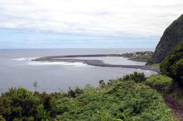
6 The Fajãs Fajã da Caldeira

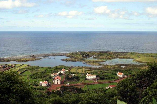
7 Fajã do Cubres Fajã do Cubres
8

9 Mira Minde Polje and related Springs. 02/12/05; Região Lisboa e Vale do Tejo; 662 ha; 39 29'N 'W. Natura 2000 site, Natural Park. A subterranean hydrological system based on the polje, or flat, closed depression draining underground, situated in the country's most important limestone karstic region and part of the recharge area of the two most important karstic aquifers and karstic springs in Portugal. The flooding episodes with very high fluctuations of groundwater level are a rare example in the West Mediterranean biogeographic region. TheAlviela spring is one of the deepest in the world and is locally connected to a cave complex that represents the most significant fluvio-karstic phenomena in Portugal, one which supports several bat colonies with more than 5,000 bats in total. The Almonda spring is related with the most extensive Portuguese cave, an important Paleolithic site. The area features important habitat types under which temporary ponds, natural eutrophic lakes, and tall humid grasslands are the most abundant. Adverse effects are mainly caused in some places by water pollution, urban and industrial developments, and increasing tourism. There are educational activities at the underground interpretation centres in the Pena and Almonda Caves as well as the interpretation centre and Cave Bats Observatory at the Alviela Springs, which welcome up to 100,000 visitors per year. Ramsar site no

10 Mondego Estuary. 02/12/05; Região Centro; 1,518 ha; 40º08'N 008º50'W; National Ecological Reserve, Important Bird Area. Comprises the estuary of the Mondego River as it passes around the Murraceira island, including intertidal areas, salt marshes, salt pans, reedbeds, rice fields and fish farms. This site is one of the main stopover and refuge areas for migrating birds along the northwestern coast of Portugal and is particularly important for waders, especially Recurvirostra avosetta and Phoenicopterus ruber. During the breeding season the site is regionally important for species such as Black-winged Stilt Himantopus himantopus and Little Tern Sterna albifrons. Aquaculture and fishing are the chief economic activities, which is focused on three migratory species of high economic value, the Sea lamprey, Allis shad, and Twaite shad. Traditional salt production has been decreasing or been transformed for aquaculture, which has led to a loss of suitable habitats for waders and other waterbirds. Potential threats come from increasing eutrophication due to intensive use of fertilisers and herbicides and the subsequent occurrence of macroalgae blooms. The neighbouring expanding harbour and the adjacent industrial region put further pressure on the site. Ramsar site no

11 URL source:
New Ramsar sites for Poland
 New Ramsar sites for Poland 31 October 2005 Poland Poland designates five new Wetlands of International Importance The Secretariat is pleased to announce that the Government of Poland has designated five
Case Study: 1. The Clarence River Catchment
 Case Study: 1. The Clarence River Catchment The NSW coastline is a great natural asset, making an enormous contribution to the economy. The resources of coastal catchments such as the Clarence River Catchment,
EUROPEAN COMMISSION DG XI.D.2. COUNCIL DIRECTIVE 79/409/EEC on the conservation of wild birds. and
 EUROPEAN COMMISSION DG XI.D.2 COUNCIL DIRECTIVE 79/409/EEC on the conservation of wild birds and COUNCIL DIRECTIVE 92/43/EEC on the conservation of natural habitats and of wild fauna and flora STANDARD
Congo names four large Ramsar sites
 Congo names four large Ramsar sites 1 February 2008 Congo The Republic of Congo designates four sites on World Wetlands Day 2008 The Direction Générale de l'environnement of the Republic of Congo has taken
Hungary and Slovak Republic cooperate on transboundary Ramsar site
 Hungary and Slovak Republic cooperate on transboundary Ramsar site 4 December 2004 Parts of the Tisza River named for the Ramsar List At the opening session of the 5th Ramsar European Meeting in Yerevan,
INTRODUCTION Background: Definitions Wetlands in Egypt Threats to Wetlands Wetland Services
 INTRODUCTION Background: Definitions Wetlands in Egypt Threats to Wetlands Wetland Services NATIONAL STRATEGY Mission: Goal Guiding Principles Objectives and Bases of Action Actions to Achieve Objectives
Croatia completes inventory of wetlands
 Croatia completes inventory of wetlands 16 October 2006 Croatia CRO-WET - Croatian Wetland Inventory SGF project completed The Croatian State Institute for Nature Protection (SINP) carried out a comprehensive
The Ramsar Convention
 The Ramsar Convention a modern successstory story for nature conservation by Tobias Salathé Ramsar Convention Secretariat www.ramsar.org Ramsar Site Cerknica lake - Slovenia 1960s : dissappearinghabitats
Belarus seminar on transboundary wetland sites
 Belarus seminar on transboundary wetland sites 12 May 2004 Belarus Transboundary Ramsar Sites On 28-29 April 2004, a seminar on transboundary wetland sites took place in the town of Lida (Republic of Belarus),
Prosjekt Amvrakikos Gulf, Greece
 Prosjekt Amvrakikos Gulf, Greece PERIODE 2012-2015 LAND Amvrakikos Gulf is a special ecosystem located in Western Greece. Amvrakikos Gulf is shared by 3 prefectures: the prefecture of Etoloakarnania (whole
Virginian Atlantic (Ecoregion 8)
") Virginian Atlantic (Ecoregion 8) Background The Virginian Atlantic Ecoregion extends from the south side of Cape Cod to Cape Hatteras in North Carolina. The waters of the ecoregion are a mix of cold and
Virginian Atlantic (Ecoregion 8) Background The Virginian Atlantic Ecoregion extends from the south side of Cape Cod to Cape Hatteras in North Carolina. The waters of the ecoregion are a mix of cold and
Forms of Natural Protection in Greece
 Forms of Natural Protection in Greece 105 th Primary School of Thessaloniki NATIONAL PARKS AND PROTECTED AREAS The irregular and constantly increasing human intervention in nature and the relentless exploitation
5 proposed wetland sites
 PROPOSED WETLAND SITES OF VIETNAM Hoang Van Thang, PhD. 5 proposed wetland sites 1. Lak Lake 2. Lo Go Sa Mat 3. Tram Chim 4. UMi Minh hthuong 5. Mui Ca Mau Lak Lake Coordinates: 12o24 22 12o26 25 N 108o09
Wetland City Accreditation of the Ramsar Convention
 CBD-COP13 5 TH GLOBAL BIODIVERSITY SUMMIT FOR CITIES AND SUBNATIONAL GOVERNMENTS Parallel Session 6D on optimal utilization of ecosystem services through landscape scale biodiversity management strategies
Wetlands Reservoirs of Biodiversity. Billy McCord, SCDNR
 Wetlands Reservoirs of Biodiversity Billy McCord, SCDNR Estuaries Tidal Deepwater Intertidal Salt Marsh Tidal Riverine Fresh & Brackish Deepwater Tidal Emergent Marsh Freshwater Riverine Seasonally Flooded
photos Department of Environment and Conservation Biodiversity Conservation
 photos Department of Environment and Conservation Biodiversity Conservation EcoEducation - making the connections to biodiversity conservation Do you consider experiential learning of biodiversity in the
Use of Wetlands for Sustainable Tourism Management
 Use of Wetlands for Sustainable Tourism Management Christine Lim a and Michael McAleer b a School of Tourism and Hotel Management, Griffith University (christine.lim@mailbox.gu.edu.au) b Department of
Prosjekt Lesina Mediteranean sea Coastal lagoon
 Prosjekt Lesina Mediteranean sea Coastal lagoon PERIODE 2012-2015 LAND The Lesina Lagoon, alternatively known as the Lake of Lesina due to its small and previously fleeting hydrological connection to the
An NPS Wetland of International Significance!
 An NPS Wetland of International Significance! A World Class Tourism Destination Linda Friar Chief of Public Affairs 305-242-7714 Linda_Friar@nps.gov The Everglades - International Recognition as a special
PRESPA BIOSPHERE RESERVE MANAGEMENT MACEDONIAN PERSPECTIVE
 PRESPA BIOSPHERE RESERVE MANAGEMENT MACEDONIAN PERSPECTIVE Secretariat by Ohrid, 10.03.2016 Prespa Ohid TBB reserve Biodiversity richness trans-boundary level Total Species richness Registered over 1500
OPG, Nuclear 2
 B iodiversity Assessment Building a Biodiversity Management Plan November 24, 2011 OPG, Nuclear 2 Biodiversity Assessment What habitat, or your site? potential habitat, is available on What species of
Caring for our Lake our Future
 Caring for our Lake our Future The Management Plan for Lake Shkodra Nature Park A Summary Photo Tonin Macaj This brochure is partly funded by the European Union Lake Shkodra: plentiful nature, long human
Management Issues in Atlantic N2K sites - a personal view from the Far West!
 National Parks and Wildlife Service of the Department of Arts, Heritage, Regional, Rural and Gaeltacht Affairs Management Issues in Atlantic N2K sites - a personal view from the Far West! 2 nd Atlantic
Overview Guandu Nature Park s Restoration
 Overview Guandu Nature Park s Restoration Chen Shih-Hung the CEO of Guandu Nature Park TAIWAN Taiwan Taipei City Guandu Plain District Guandu Plain Guandu Nature Park 3/53 In 2000 the Wild Bird Society
IMPACTS OF THE RECENT TSUNAMI ON THE BUNDALA NATIONAL PARK THE FIRST RAMSAR WETLAND IN SRI LANKA
 IMPACTS OF THE RECENT TSUNAMI ON THE BUNDALA NATIONAL PARK THE FIRST RAMSAR WETLAND IN SRI LANKA by C.N.B. Bambaradeniya, IUCN The World Conservation Union, Sri Lanka Country Office (Email: cnb@iucnsl.org)
Human-induced stresses on mangrove swamps along the Kenyan Coast
 University of Wollongong Research Online Faculty of Science - Papers (Archive) Faculty of Science, Medicine and Health 2001 Human-induced stresses on mangrove swamps along the Kenyan Coast P. A. O. Abuodha
PORTISHEAD BRANCH LINE PRELIMINARY ENVIRONMENTAL INFORMATION REPORT VOLUME 4 APPENDIX Water Receptors
 PORTISHEAD BRANCH LINE PRELIMINARY ENVIRONMENTAL INFORMATION REPORT APPENDIX 17. 3 Water Receptors Contents Section Page 1 Water Receptors... 1-1 1.1 Surface Water Features/Receptors in the Study Area
Geoscape Toronto The Oak Ridges Moraine Activity 2 - Page 1 of 10 Information Bulletin
 About 13,000 years ago as the Laurentide Ice Sheet melted, glacial meltwater accumulated between the ice sheet and the Niagara Escarpment. This formed a lake basin into which gravel and sand were deposited.
Creation of a Community-managed Biodiversity Park in the Saloum Delta of Senegal. Voré Gana Seck Director GREEN Senegal for People, Land, Ocean
 Creation of a Community-managed Biodiversity Park in the Saloum Delta of Senegal Voré Gana Seck Director GREEN Senegal for People, Land, Ocean Rationale for the Creation of the Biodiversity Park F In line
LIFE+ URBANCOWS - Restoration of urban coastal meadow complex in Pärnu town, Estonia. Bert Holm, PhD.
 LIFE+ URBANCOWS - Restoration of urban coastal meadow complex in Pärnu town, Estonia Bert Holm, PhD. bert.holm@saaremaavald.ee Pärnu town, West-Estonia A coastal town, the population of ca 40 000 inhabitants;
PARTICULARITIES AND THREATS ON THE BIODIVERSITY FROM CROATIA
 PARTICULARITIES AND THREATS ON THE BIODIVERSITY FROM CROATIA Associate Professor Ph.D. Andreea BĂLTĂREŢU Dimitrie Cantemir Christian University, Faculty of Touristic and Commercial Management, Romania
Alaskan/Fjordland Pacific (Ecoregion 22)
") Alaskan/Fjordland Pacific (Ecoregion 22) Background The Alaskan/Fjordland Pacific Ecoregion is an area of abundant marine resources. The ecoregion begins at Vancouver Island and moves up the Gulf of Alaska
Alaskan/Fjordland Pacific (Ecoregion 22) Background The Alaskan/Fjordland Pacific Ecoregion is an area of abundant marine resources. The ecoregion begins at Vancouver Island and moves up the Gulf of Alaska
3.0 EXISTING PARK & RECREATION SPACE
 3.0 EXISTING PARK & RECREATION SPACE TOWN PARK & RECREATION SPACE An inventory of current parks and recreation area in the Town of Cedarburg is shown in Table 3. These areas total roughly 381.89 acres.
Title/Name of the area: Chwaka Bay, Zanzibar
 Title/Name of the area: Chwaka Bay, Zanzibar Presented by: Dr. Charles Lugomela, Ag. Head, Department of Aquatic Sciences and Fisheries, University of Dar es Salaam, P.O. Box 35064 Dar es Salaam, Tanzania
Drin River Basin: the blue heart of the Balkans... 3
 Drin River Basin The blue heart of the Balkans 1 The Mediterranean Information Office for Environment, Culture and Sustainable Development (MIO ECSDE) is a non profit Federation of 126 Mediterranean NGOs
"ST. KLIMENT OHRIDSKI FACULTY OF GEOLOGY AND GEOGRAPHY
 SOFIA UNIVERSITY "ST. KLIMENT OHRIDSKI FACULTY OF GEOLOGY AND GEOGRAPHY APPLICATION OF THE MODEL "DRIVING FORCES PRESSURE STATE - RESPONSE FOR ASSESSMENT OF FLOOD RISK RADOSTINA BORISOVA DOCHEVA Bachelor
Twelve Apostles Marine National Park Australia
 EVALUATION REPORT Twelve Apostles Marine National Park Australia Location: Victoria, Australia coastal waters Global Ocean Refuge Status: Nominated (2017), Evaluated (2017) MPAtlas.org ID: 7703885 Manager(s):
Ecohydrology of karst poljes and their vulnerability
 Ecohydrology of karst poljes and their vulnerability Prof. emeritus O. Bonacci Faculty of Civil Engineering, Architecture and Geodesy, Split University, 21000 Split, Matice hrvatske 15, Croatia E-mail:
Bon Portage Island Conservation Campaign
 Bon Portage Island Conservation Campaign Protecting a Coastal Treasure Final Report to Nova Scotia Habitat Conservation Fund September 2012 Protection of Bon Portage Island Over the course of this two-year
Photo essay: Algerian wetlands
 Photo essay: Algerian wetlands 13 February 2001 Algeria In ceremonies in Algiers on World Wetlands Day, 2 February 2001, the Government of Algeria announced the designation of ten new Wetlands of International
Status of Mangroves in Belize
 Status of Mangroves in Belize State of the Coastal zone Summit June 7 th 2012 Nadia Bood*, Emil Cherrington and Tim Smith Outline Introduction to mangroves Importance of mangrove to Belize National status
Planning a National Aquatic Area Network (NAAN) for Conservation & Management of Rare, Threatened & Endangered Wetland Biodiversity
 for Conservation & Management of Rare, Threatened & Endangered Wetland Biodiversity") Planning a National Aquatic Area Network (NAAN) for Conservation & Management of Rare, Threatened & Endangered Wetland Biodiversity B.C. Choudhury bcc@wii.gov.in Keynote Presentation on Biodiversity &
Planning a National Aquatic Area Network (NAAN) for Conservation & Management of Rare, Threatened & Endangered Wetland Biodiversity B.C. Choudhury bcc@wii.gov.in Keynote Presentation on Biodiversity &
Designated Sites. Headlines
 Designated Sites Headlines Over 36% of the Sheffield district is covered by sites with European, national or local designation. These offer valuable habitats to wildlife, with some level of protection,
The Isonzo/Soca river basin
 Geneva September 8 th 2014 The Isonzo/Soca river basin Status and perspective on the possible Alpine river basin to be assessed The Alpine Convention Water management, risk management and adaptation to
The Lower Prut Floodplain Natural Park (Romania)
") The Lower Prut Floodplain Natural Park (Romania) Gabriela Costea Natural Sciences Museum Complex Galati (Romania) & member of the Scientific Council of the Lower Prut Floodplain Natural Park The Prut The
The Lower Prut Floodplain Natural Park (Romania) Gabriela Costea Natural Sciences Museum Complex Galati (Romania) & member of the Scientific Council of the Lower Prut Floodplain Natural Park The Prut The
Clam Harbour Provincial Park
 Clam Harbour Provincial Park Public Engagement Session Thursday, September 14 th, 2017 5:30pm 7:30pm Webbers Store 11470 Nova Scotia Trunk 7 Lake Charlotte, NS Agenda Overview of the Provincial Parks System
Priority Species, Communities, Ecosystems, and Threats
 Priority Species, Communities, Ecosystems, and Threats East Gippsland Regional Catchment Strategy 2015/2016 1.0 Objective This document aims to assist in the preparation of project applications for 2015-2016
What Is An Ecoregion?
 Ecoregions of Texas What Is An Ecoregion? Ecoregion a major ecosystem with distinctive geography, characteristic plants and animals, and ecosystems that receives uniform solar radiation and moisture Sometimes
Satoquo SEINO (Graduate School of Engineering, Kyushu University, Japan)
") A reconsideration of horseshoe crab conservation methodology in Japan over the last 100 years and prospects for a marine protected area network in Asian seas Satoquo SEINO (Graduate School of Engineering,
A reconsideration of horseshoe crab conservation methodology in Japan over the last 100 years and prospects for a marine protected area network in Asian seas Satoquo SEINO (Graduate School of Engineering,
Enhancing effectiveness of Marine Protected Areas through networking and implementation of Ecological Red-line
 Enhancing effectiveness of Marine Protected Areas through networking and implementation of Ecological Red-line Linlin Zhao the First Institute of Oceanography, SOA 18/11/2015 DADANG, VIETNAM Content 1
Region 1 Piney Woods
 Region 1 Piney Woods Piney Woods 1. This ecoregion is found in East Texas. 2. Climate: average annual rainfall of 36 to 50 inches is fairly uniformly distributed throughout the year, and humidity and temperatures
NARRABEEN LAGOON SUMMIT am Wednesday, 13 April 2005 Warringah Council Chambers, 725 Pittwater Road, Dee Why.
 NARRABEEN LAGOON SUMMIT 9.15 9.30am Wednesday, 13 April 2005 Warringah Council Chambers, 725 Pittwater Road, Dee Why. NSW Minister for the Environment, the Hon. Bob Debus I am very pleased to be here to
FIELD TRIPS PROPOSAL
 FIELD TRIPS PROPOSAL Make sure you are covered by your insurance. The Foundation for Research on Biodiversity and the Collaboration for Environmental Evidence decline any responsibility during these field
Whitemouth Falls Provincial Park. Draft Management Plan
 Whitemouth Falls Provincial Park Draft Management Plan Whitemouth Falls Provincial Park Draft Management Plan Table of Contents 1. Introduction... 3 2. Park History... 3 3. Park Attributes... 4 3.1 Natural...
Target area around Juodabale LT01
 Target area around Juodabale LT01 1 Contents Target area around Juodabale LT01... 1 Description of the area... 3 Papėčiai - Petroškai... 3 Juodabalė - Šlavantai... 3 Šlavantai Petroškai... 3 Status of
Chuckanut Ridge Fairhaven Highlands EIS Scoping Concerns
 Chuckanut Ridge Fairhaven Highlands EIS Scoping Concerns Coalition of Southside Neighborhoods CSN Comments for Fairhaven Highlands EIS Scope Hearing, Jan 16, 2008 1 Chuckanut Ridge Hilly Terrain: Potential
VARGAS ISLAND PROVINCIAL PARK
 VARGAS ISLAND PROVINCIAL PARK PURPOSE STATEMENT AND ZONING PLAN February 2003 VARGAS ISLAND PROVINCIAL PARK Purpose Statement and Zoning Plan Primary Role The primary role of Vargas Island Park is to protect
Conservation Area Management Statement
 Conservation Area Management Statement Miller Creek Wildlife Area Resolution #: Approval: Issue Date: Date of Last Revision: Table of Contents 1. Purpose....... 1 2. Property Description...... 1 2.1. Legal
MARBLE RIVER PROVINCIAL PARK
 MARBLE RIVER PROVINCIAL PARK PURPOSE STATEMENT AND ZONING PLAN March 2003 MARBLE RIVER PROVINCIAL PARK Purpose Statement and Zoning Plan Primary Role The primary role of Marble River Park is to protect
A Brief Introduction to the Wetlands Phang Nga Marine National Park. Yuppayao Saichan Department of Marine and Coastal Resources Thailand
 A Brief Introduction to the Wetlands Phang Nga Marine National Park Yuppayao Saichan Department of Marine and Coastal Resources Thailand Wetlands Phang Nga Marine National Park Location: Muang and Ta kau
Pinellas County Environmental Lands
 Pinellas County Environmental Lands In addition to traditional parks and recreation facilities, Pinellas County owns and manages a system of environmental lands that provides specialized resource-based
SAN ANTONIO RIVER IMPROVEMENTS PROJECT. April 27, 2009
 SAN ANTONIO RIVER IMPROVEMENTS PROJECT April 27, 2009 1 Project Limits 2 Project Partners City of San Antonio Provides project funding for project amenities (i.e.. Sidewalks, Landscaping, Lighting, etc.)
State of Nature 2016
 State Nature 2016 State Nature 2016 Results look up tables This document presents tables the results referred to in the report in an easy to access format. All data presented here feature in the report
Terrestrial Protected Area Nomination: Central Mangrove Wetland South-West, Grand Cayman
 Terrestrial Protected Area Nomination: Central Mangrove Wetland South-West, Grand Cayman The attached nomination, proposing that a parcel of land in the Central Mangrove Wetland be made a Protected Area
14.0 NORTHERN CALIFORNIA COAST NORTHERN FOCUS AREA Description of Area The Land
 14.1 Description of Area 14.1.1 The Land The Northern California Coast - Northern Focus Area is composed of coastal Del Norte and Humboldt counties. The boundary extends eastward from the Pacific coast
سبل تفعيل تنفيذ ا تفاقية الا راضى الرطبة فى المنطقة العربية
 CONVENTION ON WETLANDS "RAMSAR" AND THE ARAB REGION سبل تفعيل تنفيذ ا تفاقية الا راضى الرطبة فى المنطقة العربية "رامسار" National Institute of Oceanography and Fisheries WETLANDS SERVICES AND PRODUCTS
World Heritage Site 1. World Heritage Site 2 OCEANIA
 World Heritage Site 1 This site is managed by both the national government of this country in the southern hemisphere and the native people who have lived here for thousands of years. Tidal plains, lowlands,
Data on Albanian Biodiversity and Mapping
 Data on Albanian Biodiversity and Mapping Petrit Hoda University of Tirana, Botanical Garden Albana Zotaj Academy of Sciences Institute of Geographical Studies Country profile Area 28748 km2 Population
Brochures Maps and Videos
 Brochures Maps and Videos Belém map (Lisbon) - accessible tourist itinerary Devotion and Religious Festivities Devotion and Religious Festivities explores Fátima, revered as a holy place of religious devotion
International Conference on Sustainable Hydropower in the Dinaric Arc 07 Ocober 2009 Hotel Lapad, Dubrovnik, Croatia
 International Conference on Sustainable Hydropower in the Dinaric Arc 07 Ocober 2009 Hotel Lapad, Dubrovnik, Croatia 1997 WWF first projects in the region (small grants) 2009 team of 8 people (4 freshwater),
LIFE CANAL DE CASTILLA BULLETIN
 LIFE CANAL DE CASTILLA BULLETIN Quarterly Newsletter on the Life-Nature Project: Wetland Restoration and Management: Canal de Castilla Special Protection Area Editorial nº1 May 2007 Life CANAL DE CASTILLA
Crete Study Site Description
 Crete Study Site Description 1. Location Crete (the largest island of Greece) is located in the south part of Greece covering an area of 8.335 km 2 or 6.3% of the Greek territory, including the surrounding
TRANSBOUNDARY ASSESSMENT NP PLITVICE LAKES / NP UNA
 Ognjen Škunca & Željka Rajković consultants TRANSBOUNDARY ASSESSMENT NP PLITVICE LAKES / NP UNA 3 2 1 The studied TB region natural historical border between Croatian and B&H in the study area defined
Participating quarry information (Long version)
") Participating quarry information (Long version) 1. Contact information Company: PT Indocement Tunggal Prakarsa Tbk. Cirebon Plant Quarry: Latitude / Longitude: City: Region: Country: Cirebon Quarry 6 o
Participating quarry information (Long version) 1. Contact information Company: PT Indocement Tunggal Prakarsa Tbk. Cirebon Plant Quarry: Latitude / Longitude: City: Region: Country: Cirebon Quarry 6 o
GEOGRAPHY AND HISTORY
 GEOGRAPHY AND HISTORY YEAR 1, PART 1 www.vicensvives.es Contents 01 Our planet Earth 02 The representation of the Earth: maps 03 The Earth s relief 04 Rivers and seas 05 Weather and climate 06 Climates
 AGREEMENT Between Director of the Białowieża National Park, based in Białowieża (Poland) and Director of the National Park Bialowieża Forest, based in Kamieniuki (Belarus) and Head Forester of the Białowieża
BIGI PAN MUMA (MULTIPLE-USE MANAGEMENT AREA)
") BIGI PAN MUMA (MULTIPLE-USE MANAGEMENT AREA) EXCHANGE OF NATIONAL EXPERIENCES IN THE SPHERE OF DEVELOPMENT OF ENVIRONMENTALLY SUSTAINABLE COMMUNITY -BASED TOURISM IN PROTECTED NATURAL AREAS (ANPS) AMONG
BIGI PAN MUMA (MULTIPLE-USE MANAGEMENT AREA) EXCHANGE OF NATIONAL EXPERIENCES IN THE SPHERE OF DEVELOPMENT OF ENVIRONMENTALLY SUSTAINABLE COMMUNITY -BASED TOURISM IN PROTECTED NATURAL AREAS (ANPS) AMONG
Michipicoten Island Regional Plan
 Michipicoten Island Regional Plan This is one of twenty Regional Plans that support implementation of the Lake Superior Biodiversity Conservation Strategy (Strategy). The Strategy, prepared and overseen
Monitoring the Environmental Status of the Heart of Borneo
 Monitoring the Environmental Status of the Heart of Borneo By: Stephan Wulffraat The Heart of Borneo conservation initiative has been going on now for several years and has gained increasing support from
DIXIE HIGHWAY Region of Peel NAI Area # 1304, 1320, 2449, 2625, 3961
 DIXIE HIGHWAY 407 1 Region of Peel NAI Area # 1304, 1320, 2449, 2625, 3961 Toronto and Region Conservation Authority City of Brampton Size: 36 hectares Watershed: Etobicoke Creek Con 4 E, Lots 13, 14 Ownership:
Reaching the 2020 Targets with Blue-Green Infrastructure: Member State Perspectives ESTONIA
 Reaching the 2020 Targets with Blue-Green Infrastructure: Member State Perspectives ESTONIA Mart KÜLVIK Estonian University of Life Sciences With thanks to Hanno Zingel and Herdis Fridolin, MoE Est. Building
147 (BIS): KAKADU NATIONAL PARK (AUSTRALIA)
: KAKADU NATIONAL PARK (AUSTRALIA)") WORLD HERITAGE NOMINATION - IUCN SUMMARY 147 (BIS): KAKADU NATIONAL PARK (AUSTRALIA) Summary prepared by WCMCIIUCN (March 1992) based on the original nomination submitted by the Government of Australia.
WORLD HERITAGE NOMINATION - IUCN SUMMARY 147 (BIS): KAKADU NATIONAL PARK (AUSTRALIA) Summary prepared by WCMCIIUCN (March 1992) based on the original nomination submitted by the Government of Australia.
WORLD HERITAGE NOMINATION - IUCN TECHNICAL EVALUATION ST. PAUL SUBTERRANEAN RIVER NATIONAL PARK (PHILIPPINES)
") WORLD HERITAGE NOMINATION - IUCN TECHNICAL EVALUATION ST. PAUL SUBTERRANEAN RIVER NATIONAL PARK (PHILIPPINES) 1. DOCUMENTATION i) IUCN/WCMC Data Sheet: (4 references). ii) iii) Additional Literature Consulted:
WORLD HERITAGE NOMINATION - IUCN TECHNICAL EVALUATION ST. PAUL SUBTERRANEAN RIVER NATIONAL PARK (PHILIPPINES) 1. DOCUMENTATION i) IUCN/WCMC Data Sheet: (4 references). ii) iii) Additional Literature Consulted:
SUPPORT TO WATER RESOURCES MANAGEMENT IN THE DRINA RIVER BASIN DRAFT ROOF REPORT INTRODUCTION AND GENERAL APPROACH
 SUPPORT TO WATER RESOURCES MANAGEMENT IN THE DRINA RIVER BASIN DRAFT ROOF REPORT INTRODUCTION AND GENERAL APPROACH Nadja Zeleznik, REC Public Concultation Beograd, Serbia, 4 July 2017 1 1. Introduction
The Vjosa River in Albania
 The Vjosa River in Albania Europe s Wild jewel - beautiful, unknown and threatened The extensive braided river section near Tepelena would drown in a reservoir of the future Kalivaç dam. (Romy Durst) Major
Achieving Nature Conservation in Hong Kong s Protected Areas System
 Achieving Nature Conservation in Hong Kong s Protected Areas System Winnie PW KWOK Senior Wetland and Fauna Conservation Officer Agriculture, Fisheries and Conservation Department Government of HKSAR 4_001.html?pubdate=
Yard Creek Provincial Park. Management Plan
 Yard Creek Provincial Park Management Plan Draft January 2010 Yard Creek Provincial Park Management Plan Approved by: telàlsemkin/siyam/chief Scott Benton Bill Williams Squamish Executive Director ation
Special animals of the caves of the Kinabatangan need protection!
 Special animals of the caves of the Kinabatangan need protection! Limestone and caves Although limestone occupies only a very small fraction of the land area, it harbours disproportionate biodiversity.
Phoenix Habitat Restoration Projects
 Phoenix Habitat Restoration Projects Spur Cross Ranch Cave Creek (Estergard) Regional Tree and Shade Summit March 9, 2010 Desert Riparian Ecosystems Healthy riparian areas like this once existed along
This research has received funding from the
 IGU Pre conference Symposium Trier August 22 25, 2012 Freizeit und Tourismusgeographie Universität Trier This research has received funding from the European Community's Seventh Framework Program FP7/2007
ITINERARY DAYS/5NIGHTS Tuesday to Sunday (every 15 days)
") ITINERARY 2015 6 DAYS/5NIGHTS Tuesday to Sunday (every 15 days) Day 1 Tuesday Cerro Colorado, San Cristóbal Upon arrival at San Cristobal Airport, travelers pass through an airport inspection point to
ITINERARY 2015 6 DAYS/5NIGHTS Tuesday to Sunday (every 15 days) Day 1 Tuesday Cerro Colorado, San Cristóbal Upon arrival at San Cristobal Airport, travelers pass through an airport inspection point to
Glacier Route. Manteigas - Trilhos Verdes.
 estrela Manteigas - Trilhos Verdes Manteigas - Trilhos Verdes www.manteigastrilhosverdes.com QR Code For reading, point your mobile phone camera and activate the capture of the code. Extension: 17,2 km
UNIT 5 AFRICA PHYSICAL GEOGRAPHY SG 1 - PART II
 UNIT 5 AFRICA PHYSICAL GEOGRAPHY SG 1 - PART II III. CLIMATE & VEGETATION A. The four main climate zones are tropical wet, tropical wet/dry (split into monsoon & savanna), semiarid, and arid. Other climate
Ceremonies for Albania's Butrint
 Ceremonies for Albania's Butrint 18 July 2003 Albania The Ramsar Site diploma was presented to the Albanian authorities on 14 July 2003 during an official ceremony for the designation of Albania's second
Remeandring of river Lemme where crossing a fen, Jura Plateau
 Remeandring of river Lemme where crossing a fen, Jura Plateau Le pôle relais tourbières Pôle-relais tourbières (French Mire Resource Centre) It was created in 2001 during the 1st National Action Plan for
MCARTHUR SWAMP PLANNING UNIT Pit-McCloud River Watershed
 Existing Conditions & Uses Overview Spring-fed lake and rivers; valuable grazing lands and important waterfowl area Planning unit provides the only public access to Ahjumawi Lava Springs State Park 7,596
Protection of Ulcinj Saline
 Strasbourg, 25 March 2015 T-PVS/Files (2015) 21 [files21e_2015.docx] CONVENTION ON THE CONSERVATION OF EUROPEAN WILDLIFE AND NATURAL HABITATS Standing Committee 35 th meeting Strasbourg, 1-4 December 2015
Northern Pacific Sea Star
 Northern Pacific Sea Star The Northern Pacific Seastar http://www.marine.csiro.au/leafletsfolder/01npseastar.html Reproduced with permission of Craig Macaulay, CSIRO http://www.marine.csiro.au/leafletsfolder/01npseastar.html
Unit 1 Lesson 1: Introduction to the Dry Tortugas and Sustainable Seas Expedition
 Unit 1 Lesson 1: Introduction to the Dry Tortugas and Sustainable Seas Expedition Lesson Objectives: Introduce students to the historical, geographic, and ecological importance of the Dry Tortugas. Introduce
ECORREGIONAL ASSESSMENT: EASTERN CORDILLERA REAL ORIENTAL PARAMOS AND MONTANE FORESTS
 ECORREGIONAL ASSESSMENT: EASTERN CORDILLERA REAL ORIENTAL PARAMOS AND MONTANE FORESTS The Nature Conservancy, EcoCiencia y Fundación AGUA. 2005. Evaluación Ecorregional de los Páramos y Bosques Montanos