Photo Set: More than 100 households displaced from TohBoh Dam construction site in Toungoo
|
|
|
- Clementine Moody
- 5 years ago
- Views:
Transcription

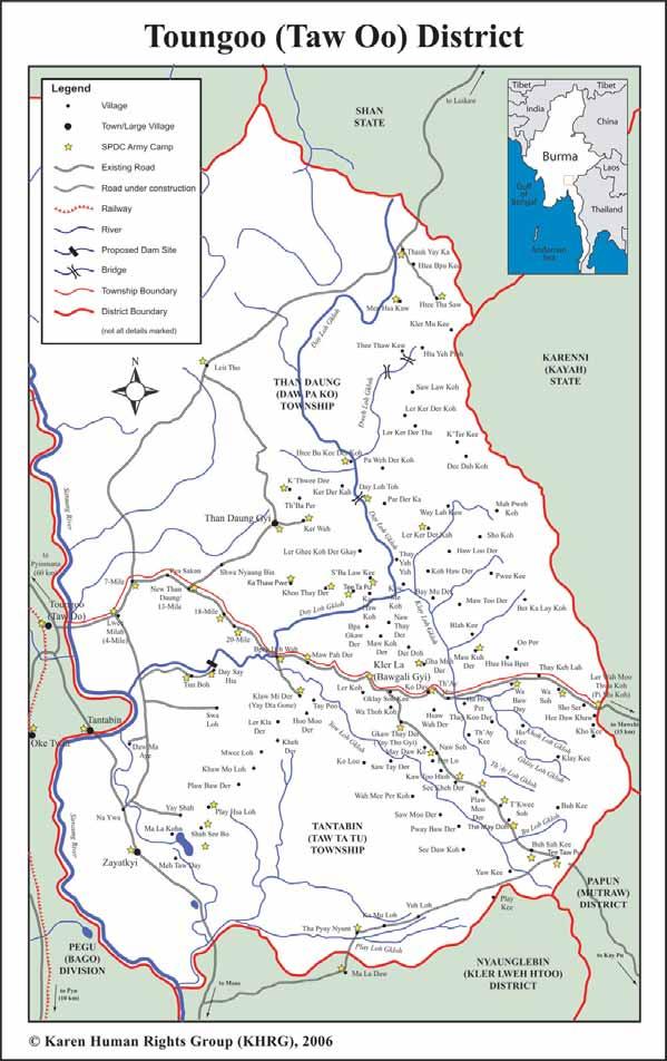
1 News Bulletin August 23, 2012 / KHRG #2012-B71 Photo Set: More than 100 households displaced from TohBoh Dam construction site in Toungoo This Photo Set presents 17 still photographs taken by a localcommunity member who has been trained by KHRG to monitor human rights conditions. 1 The photos were all taken inmarch 2012at the TohBohDam construction site in Tantabin Township within locally-definedtoungoo District. 2 According to the community member who took these photos, more than 100 households havebeen relocatedfrom the area now occupied by the dam construction site, where construction is ongoing.for additional information on the TohBoh dam, see Toungoo Interview: Saw H---, April 2010, published by KHRG on August 7 th Photo Set Tantabin Township, Toungoo District (March 2012) This photo was taken in March 2012, and shows the Day Loh River Valley in Tantabin Township, Toungoo District where the dam is being constructed. 3 Vehicle access roads in the vicinity of the dam site and large swathes of deforested land are also clearly visible. [Photo: KHRG] 1 KHRG trains villagers in eastern Burma to document individual human rights abuses using a standardised reporting format; conduct interviews with other villagers; write general updates on the situation in areas with which they are familiar; and take photographs and videos as evidence of abuse. 2 According to government designations, the dam site is in Tantabin Township, Eastern Bago Region. TohBoh is the Karen language name for the dam site and adjacent village, which is also known as TunBoh in Burmese language. 3 The river is referred to as Day Loh in the Karen language and Thauk Yay Kah in Burmese.


2 The above left photo shows vehicle roads approaching the Toh Boh Dam construction site, while the photo above right shows a bulldozer on another road. While 100 households were relocated from the dam site itself, roadbuilding in the surrounding area has the potential to destroy or limit villagers access to additional cultivable land.[photos: KHRG] The photo above left shows people and vehicles on top of the TohBoh Dam under construction. In the photo above right, a sign in black reads: Thauk Yay Khat(2) hydropower electricity project. [Photos: KHRG] 2

![4 [Photos: KHRG] The two photos above show housing areas for construction workers near the Toh Boh Dam construction site.](/docs-images/94/119530283/images/3-1.jpg "[Photos: KHRG] 4 According to a report from Free Burma Rangers (FBR) in December 2011, construction of the TohBoh Dam has displaced one village and will")


3 The photos above show electricity pylons on a different side view of the Toh Boh Dam under construction. In the photo above right, the sign in red reads: Tunnel for diverting water out. 4 [Photos: KHRG] The two photos above show housing areas for construction workers near the Toh Boh Dam construction site. [Photos: KHRG] 4 According to a report from Free Burma Rangers (FBR) in December 2011, construction of the TohBoh Dam has displaced one village and will affect 12 villages if completed. Asia World Company began building this hydropower dam in 2004 along the Day Loh Rivernear TohBoh Village, causing all the people in the village to move away. When the project is completed, flooding will affect people in 12 additional villages: Pa LehWa, Lay Mine, Mine Na Seh, Swa Lo, NawKa Maw, NgwayTaung, Toe Thaw, ThaHpanChaung, Tha Ye Ba, Joh Pin Seit, Kyaute Pa Sar and ThehPyu. Mine Na She, Swa Lo and TohBoh will likely flood, and people s livelihoods in the other ten villages will be heavily affected. In this area people use this river as their primary transportation route. See: Burma Army Shoots Villager in Pa an District and Continues Construction on TohBoh Dam in Toungoo District, Karen State, Free Burma Rangers, December 22 nd


![plantations, all of which would be flooded if the dam becomes operational. 6 [Photos: KHRG] The photos above show two different views of the powerhouse that will produce electricity from the dam.](/docs-images/94/119530283/images/4-2.jpg "The yellow pipe beneath the powerhouse allows water to enter and connect to the machine that produces hydropower.")
![[Photos: KHRG] 5 In Burmese, "betelnut" and "betel leaf" are referred to as "konywet" and "konthih," as if they are from the same plant.](/docs-images/94/119530283/images/4-3.jpg "The Burmese names are also commonly used by Karen language speakers.")
4 The photo above left shows the steel door that will control the water flow from the Day Loh River. The photo on the right shows the spillway control section, designed to regulate the amount of water flow; when the water reaches a certain elevation, the spillway control section will reduce the amount of water flow from the upper dam. According to the community member who took these photos, the surrounding agricultural land belongs to villagers from 10 villages, which includes durian, mangosteen, cardamom and betelnut 5 plantations, all of which would be flooded if the dam becomes operational. 6 [Photos: KHRG] The photos above show two different views of the powerhouse that will produce electricity from the dam. The yellow pipe beneath the powerhouse allows water to enter and connect to the machine that produces hydropower. [Photos: KHRG] 5 In Burmese, "betelnut" and "betel leaf" are referred to as "konywet" and "konthih," as if they are from the same plant. The Burmese names are also commonly used by Karen language speakers. "Betelnut" is the seed from an Areca Palm tree, areca catechu; "Betel leaf" is the leaf of the Piper betel vine, belonging to the piperaceae family. See Attacks on cardamom plantations, detention and forced labour in Toungoo District, KHRG, May FBR local community leadersestimated that over 5,000 acres of land will be flooded, including lemon, paddy rice, banana and betelnut fields. Three Tatmadaw camps ChaySoe, Pa Na WahSoe and Yaw Mu Kee surround the dam. Soldiers from Tatmadaw Infantry Battalion (IB) #39, under the Southern Command, are in each camp; see Burma Army Shoots Villager in Pa an District and Continues Construction on TohBoh Dam in Toungoo District, Karen State, Free Burma Rangers, December 22 nd


 Toungoo Situation Update: Received in November 2011, (April 2012) Toungoo Interview: Saw E---, September 2011, (April 2012) 7 In the")

5 The photos above were taken in March 2012 in the Day Loh River Valley. The top two photos show construction workers building cement terraces, reinforced with bamboo poles, which together will contain the water once the dam becomes operational. In the background, features characteristic of excavation for unknown purposes are present. 7 [Photo: KHRG] Further background on the current situation in Toungoo District can be found in the following KHRG reports: Tatmadaw soldiers fire at four villagers carrying rice, order forced labour in Toungoo District, (July 2012) Toungoo Situation Update: Tantabin Township, January to March 2012, (May 2012) Toungoo Situation Update: Received in November 2011, (April 2012) Toungoo Interview: Saw E---, September 2011, (April 2012) 7 In the interview received by KHRG along with these photos, Saw H--- describes the likelihood of mining operations occurring simultaneously with the dam construction; see Toungoo Interview: Saw H---, April 2010, KHRG, August Additionally, the top right photo resembles previous gold-mining operations along the rivers in DwehLoh Township, Papun District; see Papun Situation Update: DwehLoh Township, May 2011, KHRG, September
6 Toungoo Interview Transcript: Saw L---, December 2011," (April 2012) Toungoo Interview Transcript: Saw M---, December 2011, (March 2012) 6
7 7
Dooplaya Incident Report: Rape and Killing of a teenage girl in Kawkareik Township, August 23 rd 2016
 Incident Report January 26, 2017 / KHRG #16-89-I1 Dooplaya Incident Report: Rape and Killing of a teenage girl in Kawkareik Township, August 23 rd 2016 This Incident Report describes a killing and rape
SPDC forces attack rice harvest to force villagers into new towns
 Report from the Field November 20, 2006 / KHRG #2006-B12 SPDC forces attack rice harvest to force villagers into new towns It is now rice harvest season, and following the end of the monsoon rains the
Karen Human Rights Group News Bulletin
 Karen Human Rights Group News Bulletin News Bulletin is regularly produced by KHRG in order to provide up to date information on recent developments taking place within Karen and other areas of Burma,
Photo Set of Toungoo, Nyaunglebin, Mergui-Tavoy and Dooplaya: Road construction in four districts and villagers concerns
 Photo Set September 26, 2017 / KHRG #17-2-PS1 Photo Set of Toungoo, Nyaunglebin, Mergui-Tavoy and Dooplaya: Road construction in four districts and villagers concerns This Photo Set illustrates road construction
ECUADOR: A Case Study. How have humans changed their environment?
 ECUADOR: A Case Study How have humans changed their environment? How have humans changed their environment? Human beings over the course of history have changed their physical surroundings to meet their
Burma Thailand Railway Thanbyuzayat to 3 Pagodas Peter Winstanley and John Brereton
 Burma Thailand Railway Thanbyuzayat to 3 Pagodas Peter Winstanley and John Brereton 1. General Reference Peter s previous report on our visit to Burma during October 2012. Apart from the required visa
STOP DAMMING THE CHINDWIN
 STOP DAMMING THE CHINDWIN The Burmese military government, together with the government of India, is planning to build a giant hydroelectric dam near Tamanthi on the Chindwin River in northwest Burma s
Conflict / Complex Shelter Projects 2009 A.1. ASECTION A Conflict and Complex Disasters
 Conflict / Complex Shelter Projects 2009 A.1 ASECTION A Conflict and Complex Disasters A.1 Afghanistan - 2009 - Conflict returnees 3 A.2 Afghanistan - 2002 onwards - Returns 7 A.3 Azerbaijan - 12 - Conflict
Guide to the L. F. Manis Photographs
 This finding aid was produced using ArchivesSpace on February 29, 2016. English 2016 The Regents of the University of Nevada. All rights reserved. University of Nevada, Las Vegas. University Libraries.
1/18/07 Day 4 This was one of the highlight days of the cruise when we will pass through the Panama Canal. Our route will take us from the Caribbean
 1/18/07 Day 4 This was one of the highlight days of the cruise when we will pass through the Panama Canal. Our route will take us from the Caribbean Sea south to the Pacific Ocean through the locks, Gatun
UNITED STATES DEPARTMENT OF THE INTERIOR BUREAU OF RECLAMATION REGION 4 SALT LAKE CITY, UTAH. May 29, 1958
 UNITED STATES DEPARTMENT OF THE INTERIOR BUREAU OF RECLAMATION REGION 4 SALT LAKE CITY, UTAH May 29, 1958 FACT SHEET ON PRIME CONTRACT FOR CONSTRUCTION OF FLAMING GORGE DAM GENERAL INFORMATION Bids will
State Level Historic Documentation Report. John Blue Bridge Hampshire County
 State Level Historic Documentation Report State Project No. S314-28-22.27 Federal Project No. BR-0028(058)D John Blue Bridge Hampshire County Prepared by: Randy Epperly, Historian Department of Transportation
SECTION 3 GENERAL DESCRIPTION OF THE RIVER BASIN
 SECTION 3 GENERAL DESCRIPTION OF THE RIVER BASIN SECTION 3 GENERAL DESCRIPTION OF THE RIVER BASIN River basin description. A general description of the river basin or subbasin, as appropriate, in which
Photographic Log Client: Project Number: Site Location: Site Name: Photograph ID: Date: Location: Direction: Comments: Photograph ID:
 Photograph ID: 1 west View of one of the monitoring well and the large parking lot on the south side of Center Street. Photograph ID: 2 Monitoring well located in the middle of the parking lot located
Guide to the L. F. Manis Photographs
 This finding aid was created by Lindsay Oden on February 27, 2018. Persistent URL for this finding aid: http://n2t.net/ark:/62930/f1vk60 2018 The Regents of the University of Nevada. All rights reserved.
SHWELI UNDER SIEGE. Dams proceed amid war in Burma
 SHWELI UNDER SIEGE Dams proceed amid war in Burma published in November 2011 About this report The Ta ang Students and Youth Organization (TSYO) released Under the Boot, a report on the Shweli Hydropower
I INTRODUCTION AND BACKGROUND
 I INTRODUCTION AND BACKGROUND INTRODUCTION AND BACKGROUND - I I INTRODUCTION AND BACKGROUND a. project setting Looking south to the project site The Davenport Cement Plant (also referred to as the Cemex
Dolakha Valley Assessment, Nepal
 Dolakha Valley Assessment, Nepal Dolakha District, June 2015 SITUATION OVERVIEW INTRODUCTION Dolakha District was severely affected by the two major earthquakes that struck Nepal on 25 April and 12 May
Report on photo transect along road through Bi Doup-Nui Ba National Park
 Report on photo transect along road through Bi Doup-Nui Ba National Park Date of transect: October, 27 th 2009 Who carried out the transect: Nhan General observations: Along the road 723, from Da Lat to
Use pages to answer the following questions
 Use pages 569-573 to answer the following questions 1.Why was winning the Battle of the Atlantic so crucial to the fortunes of the Allies? 2.Why was the Battle of Stalingrad so important? 3.Why did you
Hickman s (Diamond) Mills
 Mills") Hickman s (Diamond) Mills On the east branch of Naaman's Creek, near the northwest boundary of Lower (and Upper) Chichester townships, was the saw- and grist-mill of Samuel Hickman, which was one of the
Hickman s (Diamond) Mills On the east branch of Naaman's Creek, near the northwest boundary of Lower (and Upper) Chichester townships, was the saw- and grist-mill of Samuel Hickman, which was one of the
Photo 1: Tsunami wave flowed over 4-m high breakwater. Photo 2: No damage was observed in these timber houses.
 Tohoku Chapter, Architectural Institute of Japan Reconnaissance Report (16) on Mangoku-ura and Onagawa-cho The 2011 off the Pacific Coast of Tohoku Earthquake Released on April 15, 2011 Disaster Committee,
San Antonio's River Walk Behind the scenes tour or did you know?
 San Antonio's River Walk Behind the scenes tour or did you know? Robert B. Kauffman, Ph.D 7 Hill Top Drive Frostburg, MD 21532 o: (301) 687-4474 e: rkauffman@frostburg.edu All historical slides are from
Outline of the Shinryu Head Works
 Outline of the Shinryu Head Works Midori Network Water and farmland protection Midori Network Shinryu 1. History Land reclamation began in 1890 under the initiative of the Uryu Aristocratic Farm, headed
Impacts of climate change and water induced disasters in high altitude on hydropower development in Nepal. Rijan Bhakta Kayastha, D. Sc.
 Impacts of climate change and water induced disasters in high altitude on hydropower development in Nepal Rijan Bhakta Kayastha, D. Sc. Associate Professor and Coordinator Himalayan Cryosphere, Climate
Lake Manitou Dam and Spillway Upgrade
 South Bend Lake Manitou Dam and Spillway Upgrade Fort Wayne Rochester Indiana 1828 to 2017 Lafayette Sky Medors, P.E., LFA David Nance, P.G., IDNR Project Background Location: Rochester Indiana, Central
Guide to the Virginia "Teddy" Fenton Photograph Collection on the Hoover Dam and Boulder City, Nevada
 Guide to the Virginia "Teddy" Fenton Photograph Collection on the Hoover Dam and Boulder City, Nevada This finding aid was created by Lindsay Oden on April 27, 2018. Persistent URL for this finding aid:
Hurricane Lili almost drowns Camp-Perrin, Haiti September 2002
 Hurricane Lili almost drowns Camp-Perrin, Haiti September 2002 When Hurricane Lili passed over Haiti for 3 days, on the 27 th, 28 th and 29 th of September 2002, it miraculously subsided to the level of
REPORT NUMBER 001 ARCHAEOLOGICAL DOWSING SURVEY BISHOPS SUTTON NEAR ALRESFORD HAMPSHIRE. D P BRYAN BA (Hons) MARCH 2012
 MARCH 2012") REPORT NUMBER 001 ARCHAEOLOGICAL DOWSING SURVEY AT BISHOPS SUTTON NEAR ALRESFORD HAMPSHIRE D P BRYAN BA (Hons) MARCH 2012 1 Table of Contents 1. Introduction 1.1 Project Background Page 2 1.2 Site Location
REPORT NUMBER 001 ARCHAEOLOGICAL DOWSING SURVEY AT BISHOPS SUTTON NEAR ALRESFORD HAMPSHIRE D P BRYAN BA (Hons) MARCH 2012 1 Table of Contents 1. Introduction 1.1 Project Background Page 2 1.2 Site Location
Cultural Exchange (L,D)
") Trip summary Getting there In-country support What s included Availability 12 days / 11 nights - 2 nights Ban Talae Nok, 2 nights Koh Surin, 2 nights Kuraburi,1 night Chiang Mai, 2 Night Homestay Mae Hong
Trip summary Getting there In-country support What s included Availability 12 days / 11 nights - 2 nights Ban Talae Nok, 2 nights Koh Surin, 2 nights Kuraburi,1 night Chiang Mai, 2 Night Homestay Mae Hong
Emergency Relief Efforts of 2008 China Extreme Ice-snow Storms
 Workshop on Large-Scale Disaster Recovery in APEC Emergency Relief Efforts of 2008 China Extreme Ice-snow Storms Dr. LAI Hongzhou, Deputy Director of Department of Emergency, National Disaster Reduction
Southern Metal Industry Co., Ltd. All Kind Steel Structure Manufacturing, Construction and PEB Engineering.
 Established in 1996 Company Introduction Since 1996 One of largest steel structure fabrication & providers in Myanmar Achieved ISO 9001:2008 (Quality Management) Top leading steel structure company With
LWF Myanmar CAMP SITUATION Report March 2015
 8. Ah Nauk Ye-Muslim IDPs No of Total Occupied Total < 5 Yrs 5 to 10 Yrs 11 to 17 Yrs 18-59 Yrs > 59 Yrs Male Female Shelters Rooms Rooms Population M F M F M F M F M F 97 776 776 4,531 2209 2,322 342
Excavations in a Medieval Market Town: Mountsorrel, Leicestershire,
 Excavations in a Medieval Market Town: Mountsorrel, Leicestershire, by John Lucas Mountsorrel is situated 12 kms north of Leicester and forms a linear settlement straddling the A6, Leicester to Derby road.
LAND SUBSIDENCE SOLUTIONS
 Western Madera County and Merced County LAND SUBSIDENCE SOLUTIONS Chris White Central California Irrigation District Chase Hurley San Luis Canal Company In Association with Washington Avenue Growers, Red
Logo Department Name Agency Organization Organization Address Information 5700 North Sabino Canyon Road
 Logo Department Name Agency Organization Organization Address Information United States Forest Coronado National Forest 5700 North Sabino Canyon Road Department of Service Santa Catalina Ranger District
Sakhalin-2 Phase 2 Lenders Monitoring Visit Report Annex D: Individual RoW Descriptions
 Annex D: Individual RoW Descriptions Annex D: Individual RoW Descriptions List of RoW Locations Visited KP River / Location Team Date Visited 12-14 Fault Crossing 1 and adjacent RoW Northern 31 August
THE NEW LIGHT OF MYANMAR (Friday 4 April, 1997) ***************************************************
 ***************************************************") THE NEW LIGHT OF MYANMAR (Friday 4 April, 1997) *************************************************** (1) Deputy Prime Minister receives President of Daimex Inc (2) Restoration of original appearance, architecture
THE NEW LIGHT OF MYANMAR (Friday 4 April, 1997) *************************************************** (1) Deputy Prime Minister receives President of Daimex Inc (2) Restoration of original appearance, architecture
CHATHAM COUNTY HISTORIC PRESERVATION COMMISSION HISTORIC PROPERTY DESIGNATION STAFF RECOMMENDATION
 CHATHAM COUNTY HISTORIC PRESERVATION COMMISSION HISTORIC PROPERTY DESIGNATION STAFF RECOMMENDATION ISSUE: FILE NUMBER: Designation of Pennyworth Island as a Local Historic Property DP20110328-12-1 DATE:
To view next page press Page Down or
 To view next page press Page Down or on Keyboard Centre Information PROPERTY : DEVELOPER : PROJECT MANAGER : ARCHITECTS : RETAIL STRATEGISTS : LEASING CONSULTANTS : Corner of Hinterland and Tsamaya Avenues,
Demographic Profile 2013 census
 Demographic Profile 2013 census This profile provides basic population and demographic information on the residents of the Hauraki District. Population and demographic information is important for targeting
4180 acre-feet minimum conservation pool
 MEMORANDUM Subject: Bear River Basin Plan SULPHUR CREEK RESERVOIR Date: July 20, 2000 Location: Section 34, Township 14N, Range 119W. Located on Sulphur Creek, tributary to the Bear River. Located approximately
Cave and Basin & Castle Internment Camp Site Visit Report Sarah Beaulieu December 7, 2015
 Cave and Basin & Castle Internment Camp Site Visit Report Sarah Beaulieu December 7, 2015 Figure 1.1 Cave and Basin National Historic Site Internment Exhibit Banff National Park was the site of two internment
Cultural Resource Management Report Deer Valley 4wd Restoration and Blue Lakes Road Maintenance Project R
 Cultural Resource Management Report R2015-05-03-10005 Undertaking Description: The proposes to perform road maintenance and meadow restoration on the Deer Valley 4wd trail and road maintenance on the Blue
Cau River. Map of River. Table of Basic Data. Vietnam 5
 Cau River Map of River Table of Basic Data Name: Cau River Location: Thai Nguyen, Province, Viet Nam Area: 6,030 km 2 Origin: Mt. Phia Deng 1,527 m Outlet: Pha Lai Note: * Indicates missing data in some
Agro Product Name Market Name Agro Product Variety GradPrice /Kg(Retail) Price /Kg(Wholesale) Quantity Arrivals Alternanthra-Ponnanganni
 Price /Kg(Wholesale) Quantity Arrivals Alternanthra-Ponnanganni") Agro Product Name Market Name Agro Product Variety GradPrice /Kg(Retail) Price /Kg(Wholesale) Quantity Arrivals Alternanthra-Ponnanganni leavmettupalayam Market Local 1 4.00/Bundle 5.00/Bundle - Amaranthus
Agro Product Name Market Name Agro Product Variety GradPrice /Kg(Retail) Price /Kg(Wholesale) Quantity Arrivals Alternanthra-Ponnanganni leavmettupalayam Market Local 1 4.00/Bundle 5.00/Bundle - Amaranthus
Younique Travel Adventures Vietnam Adventure September 2018 HANOI SAPA- HALONG - DA NANG- HOI AN-HOCHIMINH 13 DAYS 12 NIGHTS
 Younique Travel Adventures Vietnam Adventure September 2018 HANOI SAPA- HALONG - DA NANG- HOI AN-HOCHIMINH 13 DAYS 12 NIGHTS TRIP DETAILS Day 1: ( HANOI ARRIVAL ) (No Meal ) Arrival in Hanoi Private pick
COUNTRY DATA: Costa Rica : Information from the CIA World Factbook! INTRODUCTION GEOGRAPHY
 ! COUNTRY DATA: Costa Rica : Information from the CIA World Factbook! INTRODUCTION GEOGRAPHY Location Area Central America, bordering both the Caribbean Sea and the North Pacific Ocean, between Nicaragua
Kabul Journal by Guy Fipps
 Kabul Journal by Guy Fipps Chapter 13 The Logar Forward Operating Base April 12, 2006 The Gardez PRT headquarters is in the town of Gardez, the capital of Paktya Province. This PRT is responsible for two
Executive Summary. See Figure ES-5 on page 9. Figure ES-6: Typical At-Grade Alignment. Figure ES-7: Typical Underground Alignment
 Figure ES-5 shows all of the possible LRT routes and stations identified for study in the Draft EIS/EIR. The features and impacts of each of the build alternatives are described in the following section.
Track Torque. CHANGE OF CAMP Thursday 18th July 2013
 CHANGE OF CAMP Thursday 18th July 2013 Our time at the Mulgowie camp has come to an end. Today 20 volunteers packed up the camp and transported it to the showgrounds at Laidley. The move was necessary
COUNTRY DATA: BRAZIL: Information from the CIA World Factbook INTRODUCTION
 COUNTRY DATA: BRAZIL: Information from the CIA World Factbook INTRODUCTION Following more than three centuries under Portuguese rule, Brazil gained its independence in 1822, maintaining a monarchical system
SAN ANTONIO RIVER IMPROVEMENTS PROJECT. August 6, 2008
 SAN ANTONIO RIVER IMPROVEMENTS PROJECT August 6, 2008 1 History of the SA River Improvements 1921 Flood Olmos Dam Complete in 1929 Downtown Flood Relief Projects in 1950 s Dams on the River Channel and
APPENDIX H 2022 BASELINE NOISE EXPOSURE CONTOUR
 APPENDIX H 2022 BASELINE NOISE EXPOSURE CONTOUR This appendix sets forth the detailed input data that was used to prepare noise exposure contours for 2022 Baseline conditions. H.1 DATA SOURCES AND ASSUMPTIONS
The Holes Creek Bridge Replacement By Bradley McClelland
 The Holes Creek Bridge Replacement By Bradley McClelland Each time there is a heavy rainstorm, the folks along Sheffield Road in the Dayton, Ohio suburb of West Carrollton have cause to be concerned. Holes
BACKROADS BICYCLE/AUTOMOBILE TOUR OF MIDDLESEX, VERMONT
 BACKROADS BICYCLE/AUTOMOBILE TOUR OF MIDDLESEX, VERMONT (created and published by the Middlesex Historical Society) Welcome to a 25-mile self-guided historical tour of the backroads of Middlesex. You may
Tanintharyi Region Economic Overview. Shared borders: Mon State to the north, Andaman Sea to the west, and Thai border to the east and southeast
 Region Economic Overview Region Profile: Location: Southern Shared borders: Mon State to the north, Andaman Sea to the west, and Thai border to the east and southeast Area: 43,345 sq. km Ethnicity: Previously
Roadmaster s House. Roadmaster s House - page 1
 Roadmaster s House The Roadmaster s House is associated with the construction of the North Australian Railway in the inter-war period and provision of accommodation for railway personnel. This house was
Malvin Brown The first smokejumper death in American History
 Malvin Brown The first smokejumper death in American History Illinois Valley Community Development Organization 201 Caves Highway Cave Junction, Oregon 97523 Roger Brandt - Chair PO 2350, Cave Junction,
Chapter 4 Research on Block 13, Lots 3 and 4
 Chapter 4 Research on Block 13, Lots 3 and 4 George Calfas History Block 13, Lots 3 and 4 Oral history and the written record Squire McWorter acquired the deed to Block 13, Lots 3 and 4 in 1854. Squire
HIGH-END ECOTOURISM AS A SUSTAINABLE LAND USE OPTION IN RURAL AFRICA:
 HIGH-END ECOTOURISM AS A SUSTAINABLE LAND USE OPTION IN RURAL AFRICA: THE ROLE OF EMPLOYMENT IN POVERTY REDUCTION & SOCIAL WELFARE Sue Snyman, March 2011 sues@wilderness.co.za INTRODUCTION Rural Communities
DEFENCE AREA 52 SPEETON
 DEFENCE AREA 52 SPEETON 1. Area details: Speeton is 4½ miles S of Filey and 6 miles N of Bridlington. County: North Yorkshire. Parish: Reighton. NGR: centre of area, TA 147751. 1.1 Area Description: [see
Human Rights Yearbook : Burma 88 HRDU. shot dead. Site of killing Note. Khao, Kaeng Kham tract, Kunhing township. old village of Sai
 88 HRDU 1 Loong maha 40 1 Nai Loo 37 1 Ka Ling 40 1 Sa Ling 38 1 Ae Nang 20 1 16.06.97 Ping Nya 42 Quarter 3, Kunhing 1 Kaw Win Ta LIB 513 on the way to the old village of Sai Khao, Kaeng Kham tract, Kunhing
Langtang Valley Assessment, Nepal
 Langtang Valley Assessment, Nepal Langtang Valley, May 2015 SITUATION OVERVIEW INTRODUCTION The Langtang Mountain Valley was severely affected by the two major earthquakes that struck Nepal on 25 April
[03:01:58.06] Slate, soldiers evacuate wounded soldier to Red Cross Huey, soldier with M-60 walks through brush,
![[03:01:58.06] Slate, soldiers evacuate wounded soldier to Red Cross Huey, soldier with M-60 walks through brush,](/thumbs/86/94170837.jpg "[03:01:58.06] Slate, soldiers evacuate wounded soldier to Red Cross Huey, soldier with M-60 walks through brush,") Project Name: Vietnam War Stories Tape/File # WCNAM A27 1st DIV, Search & Destroy Transcription Date: 9/4/2009 Transcriber Name: Jason Butler Keywords: Tank, Red Cross APCs, red cross Huey, APC, soldiers
Project Name: Vietnam War Stories Tape/File # WCNAM A27 1st DIV, Search & Destroy Transcription Date: 9/4/2009 Transcriber Name: Jason Butler Keywords: Tank, Red Cross APCs, red cross Huey, APC, soldiers
Early feedback from a latrine intervention: lessons to inform course correction
 Early feedback from a latrine intervention: lessons to inform course correction Faruqe Hussain Research Investigator WASH Research Group Centre for Communicable Diseases (CCD), icddr,b Water and Health
Investigation on Development of Agricultural Monitoring System Using Satellite Data
 Investigation on Development of Agricultural Monitoring System Using Satellite Data Genya SAITO (1), Daisuke KUNII (1), Naoki ISHITSUKA (2) (1) Tohoku University, 1-1,Tsutsumidori Amamiya-machi Aoba-ku,
APPENDIX K: BUILT HERITAGE AND CULTURAL HERITAGE LANDSCAPES
 APPENDIX K: BUILT HERITAGE AND CULTURAL HERITAGE LANDSCAPES TABLE 1: Built Resources (BHR) and Cultural Heritage Landscapes (CHL) Within and Adjacent to the West Whitby Secondary Plan Area Site # 1. CHL
APPEAL OF A CONDITIONAL DEVELOPMENT PERMIT with SETBACK AND MFA VARIANCES
 Staff Presentation AGENDA ITEM #6.A Distributed 4/6/16 APPEAL OF A CONDITIONAL DEVELOPMENT PERMIT with SETBACK AND MFA VARIANCES 25541 W Fremont File #291-15-SD-VAR Town of Los Altos Hills City Council
KANCHANABURI WAR CEMETERY (DON RAK)
") KANCHANABURI WAR CEMETERY (DON RAK) Situated only 2 kilometers south of town on the bank of the Kwai Noi River, this is where to pay respect to the 1,740 prisoners of the World War II who didn't have a
KANCHANABURI WAR CEMETERY (DON RAK) Situated only 2 kilometers south of town on the bank of the Kwai Noi River, this is where to pay respect to the 1,740 prisoners of the World War II who didn't have a
Gold Coast. Rapid Transit. Chapter twelve Social impact. Chapter content
 Gold Coast Rapid Transit Chapter twelve Social impact Chapter content Social impact assessment process...235 Existing community profile...237 Consultation...238 Social impacts and mitigation strategies...239
Grimbosq Battlefield Tour RMD and our UK contingent are working up a scenario about the battle of the Grimbosq bridgehead in Normandy.
 Grimbosq Battlefield Tour RMD and our UK contingent are working up a scenario about the battle of the Grimbosq bridgehead in Normandy. We wargamers often forget that when we push our toys around the table,
CHIMNEY ROCK ARCHEOLOGICAL AREA
 CHIMNEY ROCK ARCHEOLOGICAL AREA Phone U.S. Forest Service, Pagosa Springs, Colorado at (303) 264-2268 for tour reservations and information SAN JUAN NATIONAL FOREST PAGOSA RANGER DISTRICT, ARCHULETA COUNTY,
GOOD MORNING! Pick up the paper from the stool. If you have your signed syllabus, please put it on my desk
 GOOD MORNING! Pick up the paper from the stool. If you have your signed syllabus, please put it on my desk ANCIENT GREECE 500-323 B.C.E. Think about it Describe what you already know about ancient Greece,
Remoteness Basho valley is a rather remote area in the Western Himalayan mountain range. From Islamabad it is a two day drive by car.
 Remoteness Basho valley is a rather remote area in the Western Himalayan mountain range. From Islamabad it is a two day drive by car. The first part of the journey follows the KKH along the ancient silk
DEFENCE AREA 35 FREISTON SHORE
 DEFENCE AREA 35 FREISTON SHORE 1. Area details: Freiston Shore is 2 miles E of Freiston village and 5 miles E of Boston. County: Lincolnshire. Parish: Freiston. NGR: centre of area, TF 397424. 1.1 Area
ENLOE HYDROELECTRIC PROJECT FERC PROJECT NO PUBLIC SAFETY PLAN. Final
 ENLOE HYDROELECTRIC PROJECT FERC PROJECT NO. 12569 PUBLIC SAFETY PLAN Final November 18, 2013 Okanogan Public Utility District 1331 2nd Ave N PO Box 912 Okanogan, WA 98840 ENLOE HYDROELECTRIC PROJECT FERC
European Voluntary Service Deep Roots project
 Info pack European Voluntary Service Deep Roots project Dates: 16.05.2018-12.07.2018 (59 days which include 1 day of travel) Place: Kazanlak, Bulgaria. Participants: 12 volunteers aged between 18-30 years
ARDESTIE EARTH HOUSE HISTORIC ENVIRONMENT SCOTLAND STATEMENT OF SIGNIFICANCE. Property in Care no: 24
 Property in Care no: 24 Designations: Scheduled Monument (SM90021) Taken into State care: 1953 (Guardianship) Last reviewed: 2004 HISTORIC ENVIRONMENT SCOTLAND STATEMENT OF SIGNIFICANCE ARDESTIE EARTH
Action Recommendation: Budget Impact:
 City of Fayetteville Staff Review Form Matt Mihalevich 1/16/2019 DEVELOPMENT SERVICES (620) Submitted By 2019 0050 Legistar File ID February 5th, 2019 City Council Meeting Date Agenda Item Only N/A for
Women and clean cook stoves
 Women and clean cook stoves Energy Briefing Paper This briefing paper explores the opportunities and challenges for women of switching from inefficient wood-burning cook stoves to clean cook stoves, based
The Laksi gunfight. *** WARNING: Graphic content ***
 The Laksi gunfight *** WARNING: Graphic content *** It has been almost a week since the Laksi gunfight on 1 February 2014, and the feeling that this incident was somewhat not real is still very strong.
HISTORY LESSON 6: Kingdoms, Kings and an early Republic (Key)
") HISTORY LESSON 6: Kingdoms, Kings and an early Republic (Key) W.B (pp-65) 1. How did men become rulers in the past? The rajas were chosen by the jana 2. What was the ashvamedha? The ashvamedha (horse sacrifice)
HISTORY LESSON 6: Kingdoms, Kings and an early Republic (Key) W.B (pp-65) 1. How did men become rulers in the past? The rajas were chosen by the jana 2. What was the ashvamedha? The ashvamedha (horse sacrifice)
Preparing for Writing Performance Tasks: Readying Students for Success in Writing and State Tests
 Preparing for Writing Performance Tasks: Readying Students for Success in Writing and State Tests "If students are to make knowledge their own, they must struggle with the details, wrestle with the facts,
The Vjosa River in Albania
 The Vjosa River in Albania Europe s Wild jewel - beautiful, unknown and threatened The extensive braided river section near Tepelena would drown in a reservoir of the future Kalivaç dam. (Romy Durst) Major
Cookstove Usability Field Testing Protocol: Data Collection Form
 Cookstove Usability Field Testing Protocol: Data Collection Form y Nicholas Moses and Nordica MacCarty 1. Participant Identification 1.1 Date [ dd / mm / yyyy ] / / 1.2 Time of visit [ hr : min ] : 1.3
Monitoring Report No. 278
 Roe Valley Country Park Hydroelectric Restoration Scheme Roe Valley Country Park Largy townland County Derry AE/14/30 Ruth Logue Site Specific Information Site location: Roe Valley Country Park, 41 Dogleap
1. PROJECT TITLE LOWER DRINA HYDROPOWER PLANTS
 1. PROJECT TITLE LOWER DRINA HYDROPOWER PLANTS The lower course of the Drina River covers the area downstream from the Zvornik HPP, up to the mouth of the Drina into the Sava. This section of the Drina
The Northern Tropics
 The Northern Tropics The Guianas Countries Guyana, Suriname, French Guyana Culture reflects colonial history Official Languages Guyana English Suriname Dutch French Guyana - French Religions Suriname and
Duncan Hastie, P.E. Dewberry
 FEMA s Riverine High Water Marks for Atlanta s September 2009 Flood Event Duncan Hastie, P.E. Dewberry Background High Water Mark Recovery Performed Through FEMA s Hazard Mitigation Technical Assistance
West Point Lake - Volunteer Openings Summer 2016
 West Point Lake - Volunteer Openings Summer 2016 West Point Lake is surrounded by deep forests and rolling fields extending 35 miles along the Chattahoochee River on the Alabama-Georgia state line. The
I m Glad You Asked Logging Flight Time
 I m Glad You Asked Logging Flight Time By Dick Rochfort, ATP, MCFI, CFII, MEI Logging flight time frequently generates heated discussion. The answers to many of these questions are found in the FAA regulations
Report on photo transect along road through Bi Doup-Nui Ba National Park. Date of transect: March 28th, Who carried out the transect: Nhan
 Report on photo transect along road through Bi Doup-Nui Ba National Park Date of transect: March 28th, 2010 Who carried out the transect: Nhan General observations: This photo transect is recorded for
Cahuilla Oral History Project
 http://oac.cdlib.org/findaid/ark:/13030/kt300031gc No online items Cahuilla Oral History Project Jon M. Fletcher Agua Caliente Cultural Museum 901 E Tahquitz Canyon Way Ste C-204 Palm Springs, California
Road Barn Farm, Wendover
 Road Barn Farm, Wendover Buckinghamshire Archaeological Society HISTORIC BUILDINGS REPORT / October 2012 including HS2 high-speed rail line impact assessment SURVEY, RESEARCH AND REPORT: Stewart Moir,
United States Department of the Interior National Park Service. Boundary Expansion Listed in National Register January 11, 2017
 NPS Form 10900-a (Rev. 8/2002) OMB No. 10240018 United States Department of the Interior National Park Service Boundary Expansion Listed in National Register January 11, 2017 National Register of Historic
Annex 18. Involuntary Resettlement Process Framework (In conformity with OP 4.12)
") Public Disclosure Authorized Public Disclosure Authorized Public Disclosure Authorized Public Disclosure Authorized Annex 18. Involuntary Resettlement Process Framework (In conformity with OP 4.12) 1.
Public Disclosure Authorized Public Disclosure Authorized Public Disclosure Authorized Public Disclosure Authorized Annex 18. Involuntary Resettlement Process Framework (In conformity with OP 4.12) 1.
1. Overview of Aberdeen Township and Its Waterfront
 Aberdeen 1. Overview of Aberdeen Township and Its Waterfront 1.1 Geographic Overview Aberdeen Township is a suburban township with a land area of 5.45 square miles, with about 2 miles of shoreline along
 Page 1 Original Update HISTORICAL STRUCTURE FORM FLORIDA MASTER SITE FILE Consult Guide To Historical Structure Forms for detailed instructions Site # 8OR9844 Recorder # 26 Recorder Date 2/20/08 Site Name
Following the initial soil strip archaeology is sprayed up prior to planning and excavation
 Barton Quarry & Archaeology Over the past half century quarries have been increasingly highlighted as important sources of information for geologists, palaeontologists and archaeologists, both through