Michalovce Tourist Gateway to Zemplín NATURAL BEAUTIES AND ATTRACTIONS
|
|
|
- Louisa Edwards
- 5 years ago
- Views:
Transcription


1 NATURAL BEAUTIES AND ATTRACTIONS Michalovce Tourist Gateway to Zemplín NATURAL BEAUTIES AND ATTRACTIONS

2 Protected Landscape Areas Vihorlat The Vihorlat Protected Landscape Area with its attractiveness, uniqueness, specific geological development and extraordinary fauna belongs to natural treasures of Slovakia. The mountain range Vihorlat is of volcanic origin and rises over the Eastern Slovak Lowland to an elevation of 1076 m. From the geological point of view, most of the protected landscape area belongs to neovolcanic Vihorlat Mountains. Crater rims of stratovolcano can be found in the area of the natural lake Great Vihorlat Lake (Morské oko) and at the location where the stream Porubský potok springs. Besides the above-mentioned natural curiosities, above-ground sphagnum bogs, a significant botanical locality and natural monuments can be found in this protected landscape area. Snina s stone (Sninský kameň), a natural monument, deservedly belongs to the most beautiful natural formations in the whole mountain range Vihorlat. Summit plateaus provide spectacular views of the main Vihorlat ridge, picturesque natural lake Great Vihorlat Lake, border mountain ridge of Popričné and the Eastern Slovak Lowland. This landscape area is due to its uncommon terrain, the result of which is vertical superelevation up to 800 m, rich in tourist tracks in total length of 88 km and thus ideal for walking tours. Climbing the mountain is interesting both by surrounding nature and a view it offers. Besides other precious plants, during your walks, you will probably notice telekia speciosa, which is a living symbol of Vihorlat. An educational path that leads from Remetské Hámre through Great Vihorlat Lake as far as the Vihorlat mountain top provides individual information boards about all natural beauties of this locality. natural BEAUTIES


3 Latorica The Latorica Protected Landscape Area is listed in the Ramsar List of Wetlands of International Importance and belongs to large protected areas of lowland type. It is located in the southeast of Slovakia, in Trebišov and Michalovce districts. The protected landscape area is formed by the surrounding areas of the Latorica, the Laborec and the Ondava River with the system of blind river branches, riparian forests and alluvial meadows. The uniqueness of this area lies in its rare and very precious water and marsh communities, which are exclusive to Slovakia. Here you can come across significant representatives of fauna such as purple heron, great cormorant and white-tailed eagle because the location of the area appears to play a prominent role in water bird migration. Rare aquatic species of plants can be found there such as European white water lily, yellow water lily, water soldier, water caltrop, Beckman s grass and many others.


4 National Nature Reserves Senianske Fishponds Bird Conservation Area National nature reserve Senné or Senianske fishponds (Senianske rybníky) is one of the most important ornithological localities in Central Europe. The area is listed in the Important Birds Area List and also belongs within Ramsar sites because of its high aquatic bird diversity. Researches have estimated that as much as 160 species of birds pause here on their migratory journeys and more than 50 species of birds even build nests here. The list of the birds born and bred there includes, for instance, Eurasian spoonbill, pied avocet, Western marsh-harrier or great egret, little egret and purple heron. This bird paradise can be found between the municipal areas of villages Senné and Iňačovce in Michalovce district. The territory of the national nature reserve is recognized as deserving the fifth - the strictest degree of protection. Jovsianska Hrabina Jovsianska Hrabina National Nature Reserve is a part of the Vihorlat Protected Landscape Area. It is located at the foothills of the Vihorlat Mountains, nearby adjacent village Jovsa. This spot deserves protection for its habitat of protected leucojum vernum carpaticum, which has the most optimal ecological conditions for its vegetation here and is also the place with the highest population of leucojum vernum carpaticum. Ideal conditions for vegetation are provided by water regime of the Myslina Brook, which flows through the edge of the reserve. natural BEAUTIES Jovsianska Hrabina is definitely the most beautiful in spring when leucojum vernum carpaticum blooms and surrounding meadows are covered with white flowers. However, there is still a lot to see even after the flowers finish flowering because other flowers begin to bloom, e.g. corydalis cava, anemone nemorosa, yellow anemone, two-leaf squill or lesser celandine.


5 Kašvár, Ladmovské Limestones This nature reserve can be found at the foothills of the eastern part of the Zemplín Mountains at an altitude between m in Trebišov district. Bedrock of the area is interesting since it is formed by limestones and dolomites. Major part of vegetation is represented by xerophytes and thermophilic scrub and grass plants which, however, are not primary vegetation types due to deforestation in the past. Kašvár is a crucial habitat for rare species of insects, e.g. rosalia longicorn, mantis religiosa, carabus obsoletus. Estimate of the number of butterfly species in the nature reserve is The largest butterfly in Slovakia, the giant peacock moth, can be found there besides small butterfly Vespina slovaciella, which is a world rarity because it has been known only from the Zemplín region so far. Riparian Forest of the Latorica River Riparian forest of the Latorica River is one of the most significant nature reserves of the Latorica Protected Landscape Area. If you look for relax in a quiet area of riparian forests with alluring twitter of birds, you should drive up to the Slovak-Ukrainian state border. Riparian forest of the Latorica River is also a part of the Medzibodrožie Protected Bird Area. Tajba Dead channel of the Bodrog River near the village of Streda nad Bodrogom is declared a national nature reserve under the name Tajba. Remnants of marsh communities in Medzibodrožie area, which are already quite rare nowadays, are home to a very scarce animal species listed in the Red Book of Endangered Species, the European pond turtle, which reproduces here regularly.
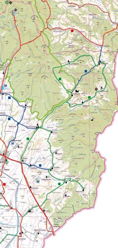
6 Cycle Routes The Region of Lower Zemplín is an ideal area for development of cyclotourism, mainly for cycling routes creation with route difficulty rated as rekrea (i.e. tracks for less skilled cyclists). It applies mainly to its lowland and hilly areas where there is a relatively rich network of the roads of lower level (second class, third class, metalled roads and unmade field tracks) with low-frequency traffic. Cyclotourists can choose from the following cycle routes: Zemplínska šírava Kaluža - Vinné (castle, Vinianske Lake) - Michalovce Michalovce - Vinné (Vinianske Lake) - Kaluža - Kusín - Jovsa - Hnojné - south part of the water reservoir Zemplínska šírava - Lúčky - Zalužice - bridge - Zemplínska šírava dyke drain - Prímestská - Michalovce (Biela Hora) Duša Michalovce - Petrovce nad Laborcom - Suché - Lesné - Pusté Čemerné - Strážske - Staré - Zbudza - Michalovce Ondavská rovina Trhovište - Moravany - Rakovec nad Ondavou - Nižný Hrabovec - Klčovo - The Ondava River dyke near Parchovany - Tušice - Tušická Nová Ves - Horovce - Trhovište Trhovište - Bánovce nad Ondavou - Bracovce - Markovce - Malčice - Oborín - The Laborec River and the Latorica River dyke - Sírnik - The Ondava River dyke - direction Horovce - Trhovište Senianske rybníky (Senianske fishponds) Michalovce - Zemplínska Široká - Iňačovce - Senianske rybníky - Senné - Palín - Zemplínska Široká - Michalovce Nová zemplínska Trasa KSK Klokočov - Michalovce - Lastomír - Sliepkovce - Stretava - Drahňov (manor house) - Vojany - Veľké Raškovce - Oborín - Brehov - Zemplín - Ladmovce - Viničky - Borša natural BEAUTIES Ukrajinská Michalovce - Zalužice - Lúčky (archaeological site) - Závadka - Nižná Rybnica - Sobrance (spa) - Tibava (vineyards) - Orechová (vineyards) - Sejkov - state border Ukraine Ublianska Sobrance - Tibava - Choňkovce - Podhoroď - Ruský Hrabovec - Ubľa Vihorlatská Sobrance (guitar museum) - Spa Sobrance - Ruskovce - Jasenov - Vyšná Rybnica - Remetské Hámre - Great Vihorlat Lake (Morské oko)
7 Medzibodrožie Streda nad Bodrogom - Viničky - Borša - Malý Kamenec - Stráže - Veľký Horeš - Malý Horeš - Pribeník - Dobrá - Biel - Veľké Trakany - Malé Trakany - Čierna nad Tisou - Boťany - direction to the rope bridge - southern dyke of the Latorica River - direction Svätá Mária - Viničky - Streda nad Bodrogom - direction to the state border Hungary - Karos Streda nad Bodrogom - Viničky - Borša - Malý Kamenec - Veľký Kamenec - Stráže - Veľký Horeš - Malý Horeš - Pribeník - Dobrá - Biel - Veľké Trakany - Malé Trakany - Čierna nad Tisou - Boťany - direction to the rope bridge - southern dyke of the Latorica River - direction Svätá Mária - Somotor - Viničky - Streda nad Bodrogom Svätuše - Kráľovský Chlmec - Malý Horeš - Pribeník - Dobrá - Biel - Bačka - Leles - Poľany - Soľnička - Boľ - Zatín - Svinice - Vojka - Kráľovský Chlmec Použie Vojany - Ižkovce - The Laborec River and the Latorica River dyke - Beša - Čičarovce - northern dyke of the Latorica River - Ptrukša - Veľké Slemence - Ruská - Kapušanské Kľačany - Veľké Kapušany - Čierne Pole - Krišovská Liesková - Vojany - Drahňov Veľké Kapušany - Kráľovský Chlmec Veľké Kapušany - Borša Vihorlatské vrchy (Dobrá voda - Borolo) Sobrance - Ruskovce - Jasenov - Vyšná Rybnica - Hlivištia - Ruská Bystrá (wooden church) - Ruský Hrabovec - Inovce - Beňatina - Podhoroď - Choňkovce - Baškovce - Spa Sobrance - Sobrance Sobrance - Tibava - Choňkovce - Koňuš - Priekopa - Porúbka - Koromľa - Husák - Vyšné Nemecké - Orechová - Tibava - Sobrance Východoslovenská rovina (Borolo - Trasa KSK) Sobrance - Ostrov - Porostov - Kristy - Svätuš - Blatná Polianka - Senianske rybníky - Senné - Blatné Remety - Bunkovce - Nižná Rybnica - Sobrance Sobrance - Tibava - Orechová - Sejkov - Jenkovce - Záhor - Pinkovce - Lekárovce - Bajany - Veľké Kapušany - Budince - Ruská - Veľké Slemence - Ptrukša - rope bridge over the Latorica River - Boťany - Čierna nad Tisou - Malé Trakany - Veľké Trakany Trebišov - Hraň - Sirník - Brehov - Zemplín - Ladmovce - Viničky - Borša Tokajské cycle routes Veľaty - Veľká Tŕňa - Malá Tŕňa - Černochov - Veľká Bara - Malá Bara - Viničky - Borša Viničky - Malá Bara - Veľká Bara - Černochov - Cejkov - Streda nad Bodrogom Trebišov - Čerhov - Slovenské Nové Mesto - Borša - direction Hungary - Sárospatak


8 LEGEND CYCLE ROUTE state border district line border of the village cadastre area main road secondary road other roads cart tracks border crossing main cycle route / marked / recommended secondary cycle route / planned linking cycle route / planned national nature reserve protected landscape area small-scale forest protected areas outlook point tourist information castle, castle ruins manor house, manor house ruins church, temple chapel, bellfry monastery, monastery ruins significant monument, memorial archeological site attractive tourist spot spa, swimming pool prírodné krásy
9

10 Natural Attractions Great Vihorlat Lake (Morské oko) Great Vihorlat Lake, called Morské oko, is a part of the national nature reserve belonging to the Vihorlat Protected Landscape Area. The lake is located directly in the heart of the mountain range Vihorlat and is one of the most splendid natural lakes in Slovakia. The lake, which is fed by the water from six pure streams, lies at an elevation of 618 m above sea level and spreads over a surface area of 13.8 ha (length of 750 m and depth of ca. 25 m). Today, 13 fish species occur in the lake and its surrounding inflows. The area provides a habitat for brown trout, rainbow trout, Eurasian minnow, European perch, European chub, gudgeon or the bleak. However, due to strict protection measures, this rare natural jewel does not allow fishing. Boating, swimming and camping are also forbidden. Beautiful and pure Vihorlat nature still looks as if it has been made for walking and hiking. Marked educational path of the Vihorlat Protected Landscape Area leads from Great Vihorlat Lake to the prominent natural monument, called Snina s stone, rising to an elevation of 1005 m above sea level. natural BEAUTIES


11 You can also exult in the beautiful scenery of the cycling route or tourist route around Great Vihorlat Lake. The route starts from the final bus stop of the village Remetské Hámre and is marked with blue signs. The circuit route around the lake ends here too. You can also take four other tourist routes from this point. Hiking trail, as well as educational path from Remetské Hámre to Great Vihorlat Lake, is 9 km long. It takes about 15 minutes to walk from the terminal park-end-ride Krivec, under Great Vihorlat Lake, to the lake. You can read lots of interesting facts about the Vihorlat Protected Landscape Area on four information boards on the fourth kilometre of this physically easy and very marvellous trail. Both hiking trail and educational path were formed by rebuilding of a railroad track into an asphalt road. At the end of the village, you can see an exhibit of the original locomotive that used to ride on this railroad until recently.

12 Snina s Stone (Sninský kameň) You can take a bit more difficult trail with a total vertical drop of m and get to the top of the protected natural formation Snina s stone, which will offer you a magnificent view of the Cirocha River Valley, Vihorlat forests and the Eastern Slovak Lowland. It is one of the best views in the whole eastern Slovakia. natural BEAUTIES Snina s stone is morphologically significant rock ridge with two summit plateaus and is confessedly one of the most striking and beautiful natural formations in entire mountain range Vihorlat. Plateaus are divided by a little saddle - a crossroad of three hiking trails. Plateaus rise above surrounding beech forests, forming almost vertical walls that reach a height of m, therefore you will need to climb up using iron ladders to see a spectacular outlook. You can get to the mountain top from Great Vihorlat Lake (red marked tourist route long 4 km), coming from the north of Sninské fishponds (blue marked tourist route long 8 km) or take the shortest but most difficult route from the village of Zemplínske Hámre (green marked tourist route long 2.2 km). You can find a detailed list of cycling routes and hiking trails on the website

13 Beňatinský Travertine Natural monument Beňatinský travertine is a part of the Vihorlat Protected Landscape Area. It is located close to the village Beňatina, northward from Sobrance, about 1 km from the Ukrainian borders. It is the easternmost travertine in Slovakia. The lake has a remarkable green colour and has neither inflow nor outflow. Travertine is forming here also today. It also attracts attention thanks to the mollusc fossil occurrence. Beautiful natural scenery reminding of Croatian rocky seashore and crystal clear water utterly allure to enjoy a carefree bathing experience.

14 Dendrologic Parks with Exotic Trees Michalovce is home to a natural attraction that is a rare 370-year old pedunculate oak. The tree is 25 m high and diameter at breast height reaches 642 cm. The oak tree is healthy, of massive growth and has irregular patulous treetop. The park called Kerta, in which the giant can be found, is one of the oldest places in the town and belongs to the conservation zone in which build ings of the mansion house together with farm buildings and premises of the Roman Catholic parish church of Virgin Mary s Birth are located. Park outplanting dates back to mid 19th century. Along with mansions, it was the Sztáray family s property. natural BEAUTIES The Town Park in Trebišov of 62 ha was designed according to the English park model in late 18th century. Woody plants that have been imported from the whole world can be found there. The most significant ones are pagoda tree, inversa variety spruce, London plane, garden variety Finnish juniper, honey locust, Kentucky coffee tree, white fir, catalpa bignonioides. The park is unique not only in terms of dendrologic reference, but also from historical and cultural point of view because there are many other protected cultural relics located in its area.


15 The town of Strážske can be proud of its natural dendrologic rarity remnants of white poplar. According to professionals, this tree was the sturdiest one in Slovakia and whole Central Europe area. The tree stem diameter was already 401 cm in 1998, stem perimeter reached the length of 12.6 m and the tree age was estimated at roughly 200 years. The poplar was also inscribed on the list of thirteen specifically listed species or groups of significant trees in Slovakia. In addition, lime tree of Matthias Corvinus in Bojnice or 700-year-old oak tree from Dubinné is listed on the list. The Count Barkóci family, who lived in Pavlovce nad Uhom in the 19th century, had a park, with area less than 20 ha around its manor house, planted out. Besides other woody plant species, a 25 m tall and 199-year old walnut tree which is a remarkable prominent landmark of this park can be found there. The Kyjov primeval forest stretches over almost 400 ha in the Vihorlat Mountains. Preservationists refer to the forest as a prospect candidate for inscription on UNESCO s World Heritage List and it is mainly thanks to 350-year-old beech trees that don t grow anywhere else. Entry to the forest is strictly prohibited and explicit permission of the caretaker is required for movement in the forest area.

16 This material was created with the financial support of European Union from European Regional Development Fund within the framework of the project Michalovce Tourist Gateway to Zemplín. EURÓPSKA ÚNIA European Regional Development Fund - An Investment in Your Future Photo: Ing. Ľudovít Földy, Szemán Tibor, Mgr. Maroš Pavlinský, Richard Max, archive of Media Group, s.r.o. and Excel enterprise, s.r.o. Graphical editing: Excel enterprise, s.r.o.
Michalovce Tourist Gateway to Zemplín LOWER ZEMPLÍN AND COUNTRY TOURISM
 LOWER ZEMPLÍN AND COUNTRY TOURISM Michalovce Tourist Gateway to Zemplín LOWER ZEMPLÍN AND COUNTRY TOURISM Museums Zemplín Museum in Michalovce Zemplín museum in Michalovce was founded in 1957. Exhibits
Discover places for relax
 Discover places for relax Surrounded by beautiful countryside, the inhabitants of Michalovce and its visitors have in plain sight flowering meadows, golden vast stretches of cereals as far as an eye can
British Mycological Society
 British Mycological Society Overseas Fungal Study Week to Slovakia Slovakia - Kaluža - hotel Glamour 20th September to 27th September Organization committee Slavomír Adamčík Miroslav Caboň Soňa Jančovičová
LET NOTHING STAND IN YOUR WAY
 LET NOTHING STAND IN YOUR WAY EURÓPSKA ÚNIA 15 tourist and hiking routes with various levels of difficulty will allow you to experience Prešov Region from a different perspective. Panoramic views, the
UNTOUCHED DIVERSITY AT THE CROSSROADS DRAVOGRAD. KORO[KA. SLOVENIA.
 UNTOUCHED DIVERSITY AT THE CROSSROADS DRAVOGRAD. KORO[KA. SLOVENIA. 2 UNTOUCHED DIVERSITY I n Dravograd the colourful geographical centre of Koro{ka, in the diverse landscape, we find a junction of three
TOP TEN. TOP TEN 10 must see spots of the Prešov Region. 10 must see spots of the Prešov Region
 TOP TEN 10 must see spots of the Prešov Region Issued by: The Prešov Self-Governing Region Námestie mieru 2, Prešov, Slovakia www.vucpo.sk 2007 Text: Veronika Fitzeková. Foto: Ladislav Cuper, Ervín Némethy,
IV International Symposium Agrosym /AGSY M NATURAL RESOURCES AND THE ENVIRONMENT OF UPPER DANUBE
 10.7251/AGSY1303899M NATURAL RESOURCES AND THE ENVIRONMENT OF UPPER DANUBE Nada MIJAJLOVIC*, Vesna POPOVIC, Jonel SUBIC Institute of Agricultural Economics, Belgrade, Serbia *(Corresponding author: nada_m@iep.bg.ac.rs)
CRAZY HORSE TRAIL GUIDE
 CRAZY HORSE TRAIL GUIDE Abridged Version: July 2016 This is a short form of our interpretive trail guide for the Crazy Horse Trail. The full version of the guide has a more detailed description of the
Forms of Natural Protection in Greece
 Forms of Natural Protection in Greece 105 th Primary School of Thessaloniki NATIONAL PARKS AND PROTECTED AREAS The irregular and constantly increasing human intervention in nature and the relentless exploitation
This Passport: Revised October 20, 2017, EAM # Discovering the Trails of Webster, NY
 This Passport: Revised October 20, 2017, EAM #161923 Discovering the Trails of Webster, NY The Town of Webster invites you to explore and experience our diverse outdoor adventures! Here s your opportunity
ZAGORI IN SITU (3-day trip)
") ZAGORI IN SITU (3-day trip) Nature and Culture Zagori is one of the most strictly protected areas in Greece due to its wild and unspoiled nature and its distinctive traditional architecture. The area is
ZAGORI IN SITU (3-day trip) Nature and Culture Zagori is one of the most strictly protected areas in Greece due to its wild and unspoiled nature and its distinctive traditional architecture. The area is
Note: Coordinates are provided as Universal Transverse Mercator UTM Zone U21, North American Datum 1983 (NAD 83).
.") Northern Traverse Route Description The Northern Traverse (formerly the North Rim Traverse) is an unmarked and rugged backcountry hiking route. It is known be a demanding hike, because of its terrain and
Northern Traverse Route Description The Northern Traverse (formerly the North Rim Traverse) is an unmarked and rugged backcountry hiking route. It is known be a demanding hike, because of its terrain and
Broadford & Ashford The Project. The Trails Flora & Fauna Mullaghareirk Ramblers. Social Media Get Involved
 Get Involved 2017 1 2 3 4 5 6 7 Broadford & Ashford The Project The Trails Flora & Fauna Mullaghareirk Ramblers Social Media Get Involved 1 Broadford & Ashford Broadford - Back beside the bridge, a quarter
New Ramsar sites for Poland
 New Ramsar sites for Poland 31 October 2005 Poland Poland designates five new Wetlands of International Importance The Secretariat is pleased to announce that the Government of Poland has designated five
12 NIGHT/13 DAY FAMILY SAFARI NORTHERN TANZANIA
 12 NIGHT/13 DAY FAMILY SAFARI NORTHERN TANZANIA Day One - Lake Manyara On arrival into Kilimanjaro you are met and transferred directly to Lake Manyara National Park. Located 125 km west of Arusha town,
Belarus seminar on transboundary wetland sites
 Belarus seminar on transboundary wetland sites 12 May 2004 Belarus Transboundary Ramsar Sites On 28-29 April 2004, a seminar on transboundary wetland sites took place in the town of Lida (Republic of Belarus),
Boatswain bay biodiversity reserve
 Boatswain bay biodiversity reserve March 2003 1 1. Plan and description 1.1. Geographic location, boundaries and dimensions The plan of the proposed Boatswain bay biodiversity reserve and its location
Wetland of Lakes Koronia and Volvi, by Themis Nasopoulou Ramsar Wetland of Lakes Koronia and Volvi
 Preliminary hour by- hour Schedule By Themis Nasopoulou Ecoguide-Journalist MSc Biological Diversity E-mail: nasthem1@hotmail.com Mob.tel.: 0030-6937122299 Ramsar Wetland of Lakes Koronia and Volvi Litohoro
IMPLEMENTATION OF MURA DRAVA REGIONAL PARK IN VIROVITICA- PODRAVINA COUNTY
 IMPLEMENTATION OF MURA DRAVA REGIONAL PARK IN VIROVITICA- PODRAVINA COUNTY Presentation prepared by: Tatjana Arnold Sabo, Public Institution for management of protected natural values in Virovitica-Podravina
KETTLE CREEK CONSERVATION AUTHORITY TRAIL GUIDE.
 KETTLE CREEK CONSERVATION AUTHORITY TRAIL GUIDE www.kettlecreekconservation.on.ca EXPLORE OUR TRAILS HIKE OUR TRAILS Kettle Creek Conservation Authority (KCCA) proudly supports and promotes an active lifestyle
The Croatian Adventure 2018
 The Croatian Adventure 2018 Info This scenic cycling tour will take you from Croatia s inland mountain region to the Adriatic coast through five national parks: Risnjak, Northern Velebit, Plitvice Lakes,
Last eruption was in 1909.
 Teide National Park Where is it?: El Teide is a giant volcano, that occupies the island of Tenerife, whose coasts are bathed by the Atlantic Ocean. It is in the Canary Islands, off the northwest coast
Discover. Ashhurst Domain. Nature s Playground
 Discover Ashhurst Domain Nature s Playground Discover Step back into New Zealand, Aotearoa, of generations long gone. Discover lush natural surrounds echoing with rich birdsong in one of the Manawatu s
Madeira Great Walks ADVENTURE NATURE
 Madeira Great Walks ADVENTURE NATURE 2018 www.portugalnaturetrails.com info@portugalnaturetrails.com Madeira Great Walks ADVENTURE NATURE DESCRIPTION Sweet paradise in the middle of Atlantic Madeira Great
PASSPORT. Discovering the Trails of Webster, NY
 PASSPORT to family wellness Discovering the Trails of Webster, NY Join the Friends of Webster Trails, Webster Health and Education Network, The Town of Webster and Wegmans to get moving more and enjoy
Butterflies and Moths of Slovakia
 Butterflies and Moths of Slovakia Slovak Karst butterfly heaven in the southeast Rosy Footman often found in our moth traps WHITE CARPATHIANS Westernmost projection of the Carpathian mountains covered
B HALL RANCH FISHTAIL, MONTANA
 Brochure Courtesy of: B HALL RANCH FISHTAIL, MONTANA w w w. m c c a s l i n l a n d. c o m Page 1 LOCATION The Hall Ranch is ideally located in the foothills of the Beartooth Mountains, approximately 5
Present-Day. History. Future. Contents. References
 Contents History Present-Day Future Introduction to the company 2 History 2 Present-Day 3 Future 3 References 3 area definition 4 Potential for development and The GLIP Project 6 GLIP basic facts 6 Transport
CAIRNS TO BRISBANE:A SELF GUIDED MOTORCYCLE TOUR
 CAIRNS TO BRISBANE:A SELF GUIDED MOTORCYCLE TOUR E S T A D V I C E - B E S T T O U R S - B E S T B I K E S B E S T A D V I C E - B E S T T O U R S - B E S T B I K E S B The Great Barrier Reef & Cairns
BRISBANE TO CAIRNS:A SELF GUIDED MOTORCYCLE TOUR
 BRISBANE TO CAIRNS:A SELF GUIDED MOTORCYCLE TOUR E S T A D V I C E - B E S T T O U R S - B E S T B I K E S B E S T A D V I C E - B E S T T O U R S - B E S T B I K E S B Sunshine Coast and Noosa Sunshine
Colorado Life Zone Scavenger Hunt
 Colorado Life Zone Scavenger Hunt Below are worksheets created for all the habitats or life zones. They were designed with the intention of breaking the class up into small groups, and having students
Tambopata Eco Lodge Programs
 Tambopata Eco Lodge Programs Rainforest Experience After your flight to the jungle town of Puerto Maldonado you will be met by our staff, who will escort you during the fascinating three-hour boat trip
FINAL STAG E : 5 T H G R A D E
 NAME COURSE SURNAME CENTRE YOUR TEACHER S NAME FINAL STAG E : 5 T H G R A D E 1. Read Danny s diary and complete his timetable. Remember there are extra words! EXTINCT / WATERFALL / VALLEY / PATH / WOOD
Significant Natural Area Assessment. Property Name: Hillend Station
 Private Bag 50072, Queenstown 9348, New Zealand QUEENSTOWN, 10 Gorge Road, Phone +64 3 441 0499, Fax +64 3 450 2223 WANAKA, 47 Ardmore Street, Phone +64 3 443 0024, Fax +64 3 450 2223 Significant Natural
BURGES JAMES GADSDEN PROVINCIAL PARK PURPOSE STATEMENT AND ZONING PLAN
 BURGES JAMES GADSDEN PROVINCIAL PARK PURPOSE STATEMENT AND ZONING PLAN February 2003 BURGES JAMES GADSDEN PROVINCIAL PARK Purpose Statement and Zoning Plan Primary Role The primary role of Burges James
Blanco Creek Ranch Acres, Uvalde County, Texas
 Blanco Creek Ranch 1208.30 Acres, Uvalde County, Texas James King, Agent Office 432 426.2024 Cell 432 386.2821 James@KingLandWater.com Blanco Creek Ranch 1208.30 acres Uvalde County, Texas James King,
Île du Beurre. The Beaver Island. Discovery map
 Île du Beurre The Beaver Island Discovery map A remnant of the Wild Rhône In the Rhône valley, the fight against flooding and the growth in human activities has put considerable pressure on the river Rhône
MCARTHUR SWAMP PLANNING UNIT Pit-McCloud River Watershed
 Existing Conditions & Uses Overview Spring-fed lake and rivers; valuable grazing lands and important waterfowl area Planning unit provides the only public access to Ahjumawi Lava Springs State Park 7,596
Join us on a magical TOUR DE FRANCE: Paris, Fontainebleau, Ardèche, Calanques & Chamonix
 Join us on a magical TOUR DE FRANCE: Paris, Fontainebleau, Ardèche, Calanques & Chamonix on an exclusive adventure trip with the through a mix of spectacular activities: Hiking, rock- climbing, canyoning,
The role of Primeval Beech Forests in the Carpathians in regional water management
 The role of Primeval Beech Forests in the Carpathians in regional water management Lubos Jurík Klaudia Halászová Zlatica Muchová Jozef Halva Slovak University of Agriculture in Nitra Slovakia UNESCO Sites
Simien Mountain Trek and Lalibela (ES 2017)
") Simien Mountain Trek and Lalibela (ES 2017) TRIPDURATIO 13 DAYS Tour Style: Classic Tour Type: Small Groups Trip Code: ES Accommodation Grade: Simple Trek Grade: Challenging Trip Highlights - Simien Mountain
Simien Mountain Trek and Lalibela (ES 2017) TRIPDURATIO 13 DAYS Tour Style: Classic Tour Type: Small Groups Trip Code: ES Accommodation Grade: Simple Trek Grade: Challenging Trip Highlights - Simien Mountain
Whitemouth Falls Provincial Park. Draft Management Plan
 Whitemouth Falls Provincial Park Draft Management Plan Whitemouth Falls Provincial Park Draft Management Plan Table of Contents 1. Introduction... 3 2. Park History... 3 3. Park Attributes... 4 3.1 Natural...
 AGREEMENT Between Director of the Białowieża National Park, based in Białowieża (Poland) and Director of the National Park Bialowieża Forest, based in Kamieniuki (Belarus) and Head Forester of the Białowieża
Woodland Mountain Property
 Woodland Mountain Property So Close, Yet So Far Away Summit County, Utah 5 Acres $79,000 3616 Elmwood Street, Salt Lake City, UT 84106 801-870-1801 info@landrancher.com Welcome to Woodland Mountain Enjoy
Cuyahoga Valley National Park Ohio
 Cuyahoga Valley National Park Ohio Brandywine Falls The Ledges The Beaver Marsh Temperate Deciduous Forest How To Get There... Located between Cleveland & Akron, Ohio Cuyahoga Valley National Park can
Bike Tours Sao Miguel Island, Azores
 Bike Tours Sao Miguel Island, Azores Departures from Ponta Delgada, Sao Miguel Island Imagine being surrounded by endemic flora and green pastures while riding over the rim of a volcanic crater that has
Costa Rica Natural Paradise 9 Days from $1195
 1 800 422 3727 Costa Rica Natural Paradise 9 Days from $1195 Day 1 San José, Costa Rica Welcome to the rich coast, friendly land of democracy and rare natural beauty. With naturalist guides, see exotic
FICHE DE PRÉSENTATION DE PROJET TITRE : BOURGAS REGION - FIRE DANCE, BIRDS, NATURE AND SEA PAYS : BULGARIE
 FICHE DE PRÉSENTATION DE PROJET TITRE : BOURGAS REGION - FIRE DANCE, BIRDS, NATURE AND SEA PAYS : BULGARIE 1. Background Bourgas region is the most south-eastern part of Bulgaria. It is located on the
The rewards more than make up for the efforts of seeing the country this is a truly unforgettable trek.
 MADAGASCAR TREK ORANGE 2 ABOUT THE CHALLENGE This exciting trek takes us to remote Madagascar, where spectacular scenery and amazing wildlife awaits! From canyons and gorges to bush-covered plains and
SAMt. INCA tour Chile - Peru. Total Kilometers days 10 nights
 An ADVENTURE of an incredible mixture of mystical archaeology sites and historical monuments, amazing nature combined with one of the oldest and most diverse cultures in South America. LIFE IS NOT - WITHOUT
A day with Macedonian Archaeology Arheo Park Brazda
 A day with Macedonian Archaeology Arheo Park Brazda The archeological site Gradiste Brazda is situated nearly 15 km north of Skopje, on a humble hill that rises over the village of Brazda. According to
ESIA Albania Annex Field Data Sheets Large Carnivores
 ESIA Albania Annex 6.2.1.8 Field Data Sheets Page 2 of 30 TABLE OF CONTENTS 6.2.1.8 Field Data Sheets... 3 Page 3 of 30 6.2.1.8 Field Data Sheets This Annex should be read in conjunction with Annex 4.1.
Watchorn Provincial Park. Management Plan
 Watchorn Provincial Park Management Plan 2 Watchorn Provincial Park Table of Contents 1. Introduction... 3 2. Park History... 3 3. Park Attributes... 3 3.1 Natural... 4 3.2 Recreational... 4 3.3 Additional
MT KILIMANJARO TREK- LEMOSHO ROUTE
 #Trekking MT KILIMANJARO TREK- LEMOSHO ROUTE 10 Days 9 Nights Overview Take the challenging and less-travelled Lemosho route up to the highest peak in Africa, considered by many to be the most beautiful
Cycling Package in Corinthia 7 Days
 Cycling Package in Corinthia 7 Days We are in a place of special natural beauty, rich in landscapes and dense forests. With sea-side paths, mountain paths with breathtaking views, monuments and archeological
 Routes around Solsona The surroundings of Solsona, called el Vinyet, preserve an old mosaic of forests, fields, farmhouses and stone walls. The group of suggested routes has a low level of difficulty and
Marchand Provincial Park. Management Plan
 Marchand Provincial Park Management Plan 2 Marchand Provincial Park Table of Contents 1. Introduction... 3 2. Park History... 3 3. Park Attributes... 4 3.1 Natural... 4 3.2 Recreational... 4 3.3 Additional
STORNETTA BROTHERS COASTAL RANCH
 STORNETTA BROTHERS COASTAL RANCH Location: Surrounding Point Arena Lighthouse and immediately south of Manchester State Park Mendocino Co., CA Acres: 1,860 Resources: Over two miles of Pacific Ocean coastline
Riding Under The Shadow of the 8th Wonder of The World Cycling in Sigiriya. Discover The Ancient Fortress of Sigiriya on Two Wheels
 Sigiriya Cycle Tour Riding Under The Shadow of the 8th Wonder of The World Cycling in Sigiriya. Discover The Ancient Fortress of Sigiriya on Two Wheels SLDT/1702/CY03 Why should you book this trip? Sri
Explore Madeira Island COASTAL NATURE SUMMER WINTER
 Explore Madeira Island COASTAL NATURE SUMMER WINTER 2018 www.portugalnaturetrails.com info@portugalnaturetrails.com Explore Madeira Island COASTAL NATURE SUMMER WINTER DESCRIPTION Walk into the wild paradise
Hungary and Slovak Republic cooperate on transboundary Ramsar site
 Hungary and Slovak Republic cooperate on transboundary Ramsar site 4 December 2004 Parts of the Tisza River named for the Ramsar List At the opening session of the 5th Ramsar European Meeting in Yerevan,
26 Utah s Patchwork Parkway SCENIC BYWAY CORRIDOR MANAGEMENT PLAN (SR 143)
") Natural Natural Quality applies to those features in the visual environment that are in a relatively undisturbed state. These features predate the arrival of human populations and may include geological
Natural Natural Quality applies to those features in the visual environment that are in a relatively undisturbed state. These features predate the arrival of human populations and may include geological
Welcome to the Bükk National Park! András Schmotzer research adviser Bükk National Park, Eger - Hungary
 Welcome to the Bükk National Park! András Schmotzer research adviser Bükk National Park, Eger - Hungary Biogeographical Process Meeting on the impact of the common agricultural policy on grassland habitats
MONTENEGRO Guided Tour Guide cycling with group 270 km/168 mi 7 nights / 8 days
 MONTENEGRO 2018 Guided Tour Guide cycling with group 270 km/168 mi 7 nights / 8 days The best way to explore Montenegro is by bike. On this tour, we discover some particularly picturesque towns as well
Stephens State Park Trails
 TRAILS OF ALLAMUCHY MOUNTAIN & STEPHENS STATE PARKS Allamuchy Mountain and Stephens State Parks contain 28 marked trails providing access to diverse landscapes for walking, hiking, biking, bird-watching,
Terrestrial Protected Area Nomination: Central Mangrove Wetland South-West, Grand Cayman
 Terrestrial Protected Area Nomination: Central Mangrove Wetland South-West, Grand Cayman The attached nomination, proposing that a parcel of land in the Central Mangrove Wetland be made a Protected Area
Illawarra Escarpment State Conservation Area Walking Tracks
 Illawarra Escarpment State Conservation Area Walking Tracks NPWS Illawarra Area Office Ground Floor, Government Office Block 84 Crown Street Wollongong NSW 2500 02 4223 3000 (Mon-Fri) Royal National Park
Geoscape Toronto The Oak Ridges Moraine Activity 2 - Page 1 of 10 Information Bulletin
 About 13,000 years ago as the Laurentide Ice Sheet melted, glacial meltwater accumulated between the ice sheet and the Niagara Escarpment. This formed a lake basin into which gravel and sand were deposited.
Silver-washed Fritillaries in the Straits Inclosure in July
 ALICE HOLT FOREST Hampshire from www.discoverbutterflies.com the website for the book Discover Butterflies in Britain D E Newland Silver-washed Fritillaries in the Straits Inclosure in July Alice Holt
Danube Cycle Path. Hungarian Rhapsody
 Danube Cycle Path Hungarian Rhapsody Vienna Budapest The cycling tour from Vienna to Budapest is a very diverse adventure with extensive majestic highlights. Your tour starts in Vienna, the worlds City
Kuruwita Erathna Trail to Sri Pada (Adam s Peak)
") Kuruwita Erathna Trail to Sri Pada (Adam s Peak) Trail Difficulty: Easy Moderate Strenuous Tough Trail Head: Adevikanda, Erathna (near entrance to mini-hydro power plant) Nearest Town: Erathna Nearest
Kuruwita Erathna Trail to Sri Pada (Adam s Peak) Trail Difficulty: Easy Moderate Strenuous Tough Trail Head: Adevikanda, Erathna (near entrance to mini-hydro power plant) Nearest Town: Erathna Nearest
Eurosite Annual Meeting 2016
 Serres, Greece 7-10 November 2016 Ecosystems at your service: how to incorporate ecosystem services into practical site management hosted by the Hunting Federation of Macedonia & Thrace, Hellas supported
Lierne. A living ice age landscape. Norway s national parks nature as it was meant to be
 BENNETT. Print: Trykkpartner Lade Lierne A living ice age landscape TE1188 Norway s national parks nature as it was meant to be Norway s national parks are regulated by the laws of nature. Nature decides
TRAILS WHERE TO FIND TRAILS IN NOVA SCOTIA
 TRAILs SIGNAGE Know the Signs............................ 44 WHERE YOU CAN RIDE Roads and Highways........................ 46 Designated Trails........................... 47 Established Trails...........................
Abbey Chesterton bridge Questions & Answers
 Abbey Chesterton bridge Questions & Answers Please click on links below to go to individual subjects: Bridge location and access routes Timescales Bridge details and accessibility Construction compound
Discover. Take a seat in the front row, watching the theatre of mother nature unfold. IGUAZÚ ENJOY THE EXPERIENCE
 Discover IGUAZÚ ENJOY THE EXPERIENCE Take a seat in the front row, watching the theatre of mother nature unfold. ARGENTINA, SOUTH AMERICA Iguazú WELCOME Please don t forget to bring the following items
EUROPEAN COMMISSION DG XI.D.2. COUNCIL DIRECTIVE 79/409/EEC on the conservation of wild birds. and
 EUROPEAN COMMISSION DG XI.D.2 COUNCIL DIRECTIVE 79/409/EEC on the conservation of wild birds and COUNCIL DIRECTIVE 92/43/EEC on the conservation of natural habitats and of wild fauna and flora STANDARD
proof Northwest District
 1 Northwest District The Northwest Florida Water Management District is the most rural of all five water management districts. From just east of Tallahassee west to the Florida/Alabama line, and from the
BEFORE PROJECT THE BEGINNING
 BEFORE PROJECT THE BEGINNING SWBNP is a final sample of the former Lakes of Danube. On an area of 241 km2, PN-BmB retain 10% of the former Inland River Delta, the former Lake of Brăila and Ialomiţei, who
CELEBRATE WEST GREENWICH GEOCACHING THROUGHOUT WEST GREENWICH
 CELEBRATE WEST GREENWICH GEOCACHING THROUGHOUT WEST GREENWICH The West Greenwich Land Trust (WGLT) is sponsoring Celebrate West Greenwich, an event designed to celebrate the beauty and history of scenic
INTERNATIONAL BIRD STRIKE COMMITTEE Amsterdam, April 2000 PHOENIX RIO SALADO/TEMPE TOWN LAKE
 INTERNATIONAL BIRD STRIKE COMMITTEE IBSC25/WP-AV1 Amsterdam, 17-21 April 2000 PHOENIX RIO SALADO/TEMPE TOWN LAKE Paul Eschenfelder US Air Line Pilots Association, 16326 Cranwood, Spring, Texas 77379, USA
EXPLORE DISCOVER LEARN CONNECT ENJOY Unique holidays in North Cyprus with the local experts
 Vivid Cyprus is an established North Cyprus holiday and tour agency which offers a personalised service for its clients before and during their Northern Cyprus holiday. As one of the pioneers of responsible
Charnley Explorer June 24 - July 15, 2018 Bachsten Creek and the Charnley River. Second draft: 14 November 2017
 Charnley Explorer June 24 - July 15, 2018 Bachsten Creek and the Charnley River. Second draft: 14 November 2017 The best part of the original section one is now part of out Gibb Road Gorges trip. The dates
SPECTACLE LAKE PROVINCIAL PARK PURPOSE STATEMENT AND ZONING PLAN
 SPECTACLE LAKE PROVINCIAL PARK PURPOSE STATEMENT AND ZONING PLAN August 2003 1 SPECTACLE LAKE PROVINCIAL PARK Purpose Statement and Zoning Plan Primary Role The primary role of Spectacle Lake Park is to
From the car park go through the wooden gate and walk to a large information board and wooden totem pole ahead of you.
 Trail Dave Price, Geograph (CCL) Twin peaks What are these striking wooded hills here in an otherwise flat landscape? Time: 40-60 mins Distance: 1 ¼ miles Landscape: rural Standing at over 300 feet tall
The Pearl of Africa: A Survey of Uganda's National Parks
 The Pearl of Africa: A Survey of Uganda's National Parks June 24, 2015 Uganda's natural beauty has hardly escaped notice. In 1909, Sir Winston Churchill famously called it the Pearl of Africa, a sentiment
Achieving Nature Conservation in Hong Kong s Protected Areas System
 Achieving Nature Conservation in Hong Kong s Protected Areas System Winnie PW KWOK Senior Wetland and Fauna Conservation Officer Agriculture, Fisheries and Conservation Department Government of HKSAR 4_001.html?pubdate=
EXPLORE KLARÄLVSDELTAT BY BIKE
 EXPLORE KLARÄLVSDELTAT BY BIKE EXPLORE NATURE BY BIKE THE BIKE TRAIL 1. Stadsträdgården (City garden) park was laid out in 1861 and there was a restaurant here from 1870 to 1959. In the northwest corner
PROJECT CHARTER IN THE FOOTSTEPS OF NOBLE FAMILIES PÁLFFY AND ESTERHÁZY
 PROJECT CHARTER IN THE FOOTSTEPS OF NOBLE FAMILIES PÁLFFY AND ESTERHÁZY Project title: Programme: INTERREG VA SK-AT/ Priority axis 2: Fostering natural and cultural heritage and biodiversity Investment
Chateau Du Chevalier Region: Brittany Sleeps: 15-35
 Chateau Du Chevalier Region: Brittany Sleeps: 15-35 Overview For an unforgettable family holiday or fairytale wedding, book Chateau Du Chevalier, a magnificent 15th century castle in Brittany. Beautifully
MILL HILL West Sussex
 MILL HILL West Sussex from www.discoverbutterflies.com the website for the book Discover Butterflies in Britain D E Newland Shoreham Bank, the south-western slope of Mill Hill, looking north in August
COAST TO COAST RAINFOREST TREK
 COSTA RICA TREK TOUGH ABOUT THE CHALLENGE Our adventurous coast to coast rainforest trek involves crossing from Costa Rica's Pacific Coast to the Caribbean. Enroute we take in the country s highest active
Pinawa Provincial Park. Draft Management Plan
 Pinawa Provincial Park Draft Management Plan Pinawa Provincial Park Draft Management Plan Table of Contents 1. Introduction... 3 2. Park History... 3 3. Park Attributes... 4 3.1 Natural... 4 3.2 Recreational...
Kermadec. Ocean Sanctuary
 Kermadec Ocean Sanctuary Kermadec Ocean Sanctuary, New Zealand Pacific Remote Islands National Marine Monument, United States Coral Sea Marine Reserve, Australia Proposed Pitcairn Marine Reserve, United
Proposed Ruisseau- Clinchamp ecological reserve
 Proposed Ruisseau- Clinchamp ecological reserve October 2003 1. Plan and description 1.1. Geographic location, boundaries and dimensions The plans of the boundaries of the proposed Ruisseau-Clinchamp ecological
PROVENCE LAVENDER TOUR
 Longitude 180 Small Group Walking Tour Active Travel Specialist PROVENCE LAVENDER TOUR What can be more ubiquitously Provençal than lavender? A sea of fragrant purple flowers carpeting the rolling hills
MANAGEMENT DIRECTION STATEMENT
 Lower Mainland District MAAGEMET DIRECTIO STATEMET January 2001 for Liumchen Ecological Reserve Ministry of Environment Lands and Parks BC Parks Division Table of Contents Page Introduction... 1 Purpose
Brador hills biodiversity reserve
 Brador hills biodiversity reserve September 2003 1. Plan and description 1.1. Geographic location, boundaries and dimensions The plan of the proposed Brador hills biodiversity reserve and its location
Bhutan Fesival Tour 2018 (no tour escort English-speaking Bhutan guide only)
") Wander Tours P.O. Box 16102 Seattle WA 98116 Bhutan Fesival Tour 2018 (no tour escort English-speaking Bhutan guide only) Itinerary dates: October 20 October 30, 2018 HIGHLIGHTS * Hike to Tiger s Nest,
Wander Tours P.O. Box 16102 Seattle WA 98116 Bhutan Fesival Tour 2018 (no tour escort English-speaking Bhutan guide only) Itinerary dates: October 20 October 30, 2018 HIGHLIGHTS * Hike to Tiger s Nest,
Aida Maria Yacht Itinerary 6 Days "E"
 Aida Maria Yacht Aida Maria Yacht Itinerary 6 Days "E" Day Activities 1 Santa Cruz Highlands: Upon your arrival to Baltra Airport, you will be transferred to the Aida Maria Yacht. After lunch, we take