DEPARTMENT OF NAVIGATION AND OCEANOGRAPHY MINISTRY OF DEFENSE OF THE RUSSIAN FEDERATION NATIONAL REPORT OF THE RUSSIAN FEDERATION
|
|
|
- Stephanie Moore
- 5 years ago
- Views:
Transcription

1 DEPARTMENT OF NAVIGATION AND OCEANOGRAPHY MINISTRY OF DEFENSE OF THE RUSSIAN FEDERATION NATIONAL REPORT OF THE RUSSIAN FEDERATION 18-th MEETING of BALTIC SEA HYDROGRAPHIC COMMISSION Estonia, Tallinn, September, 2013
2 The present report reflects activity results of the Hydrographic Office of the Russian Federation since the last submission of the national report at the 17-th meeting of BSHC, September 2012, Helsinki Hydrographic Office In accordance with the legislation of the Russian Federation, matters of navigational and hydrographic support of navigation in marine waters under national jurisdiction, except for the tracks of the Northern Sea Route, have been attributed to the competence of the Ministry of Defense of the Russian Federation. Functions of planning and organization of navigational and hydrographic support of navigation in marine waters under national jurisdiction and in the high seas is entrusted to the Department of Navigation and Oceanography of the Russian Federation Ministry of Defense (abbreviated DNO of the RF MD). Department of Navigation and Oceanography is an organization authorized by the Ministry of Defense of the Russian Federation, and it represents the State in civil legal relations arising in the field of navigational and hydrographic support of navigation. It is in charge of the Hydrographic Office of the Navy. The basic directions of activity of the Hydrographic Office of the Navy are: oceanographic, hydrographic and marine geophysical researches in maritime waters under national jurisdiction and in the high sea; edition of nautical charts, manuals and publications for all parts of the World Ocean and corresponding supply of mentioned products to Russian and foreign mariners; collecting and making available for mariners information on changes in sailing conditions and regime of navigation in maritime waters under national jurisdiction and in the high seas; maintenance, improvement and development of aids to navigation in the seas along the coast and in marine waters under national jurisdiction of the Russian Federation, with the exception of the tracks of the Northern Sea Route. Hydrographic Office of the Navy consists of units based in St. Petersburg, and regional hydrographic services for the Northern, Pacific, Baltic, Black Sea and Caspian Sea Regions. Subdivisions of regional hydrographic services: expeditions, hydrographic groups and parties directly carry out totality of oceanographic, hydrographic and
3 geophysical works, produce processing and transmitting of the materials to the Charts Division of the Navy. Hydrographic Office of the Navy participates in joint, including international, oceanographic and hydrographic expeditions. Department of Navigation and Oceanography directs preparation and edition of new navigational charts, manuals and publications and reissue of existing ones. Direct preparation and edition of charts, manuals and publications are realized in the Charts Division of the Navy. Materials of hydrographic research carried out by regional hydrographic services, as well as contributions from interagency cooperation to hydrographic researches, serve as a base for edition of charts and books. 3
4 Vyborgskiy Zaliv Luzhskaya Guba 4 No. 2. Surveys 2.1. Areas of Coverage by New Surveys Area of Activity Kind of Activity Scale Table 1 Year of Activity Gulf of Finland 1 Water area of two-way route of icebreaker assistance through Ostrovnoy Passage between Rif Ostrovnoy and Rif Kurgal skiy and passage between Banka Garkalamatala and Banka Velimatala South of Ostrov Seskar Area survey 1: : Water Area of Canal of Kronshtadtskiy Korabel nyy Fairway Area survey and topographic survey 1: Water Area of Bol shoy Kronshtadtskiy Roads Area No 3 Water Area of Basin of Neftyanaya Gavan Area survey 1: Water Area of Anchorage No 18E Area survey 1: Luzhskiy Morskoy Kanal - Luzhskiy Severnyy Kanal - Luzhskiy Zapadnyy Kanal -Ust -Luzhskiy Kanal Luzhskiy Morskoy Kanal Luzhskiy Zapadnyy Kanal Maneuvering Water Areas and objects of dredging of Port Ust -Luga Novaya Gavan Terminal Dumping Ground No 315 Ust -Luga Seaport - Water Area of Northern Approach Canal - Yug-2 Water Area(of Southern Area) Area survey Area survey and topographic survey Area survey 1: : : : : Water Area of Vyborg Seaport 1: Vyborgskiy Morskoy Kanal Vnutrenniy Vysotskiy Roads GV-2 8 Water Area of Bulk-oil Terminal of Vysotsk Lukoil-II Unloading-Loading Complex Area survey Approach Canal to Vysotsk Lukoil-II Unloading- Loading Complex Vessel Traffic Scheme (in the vicinity of Ostrov Sommers)
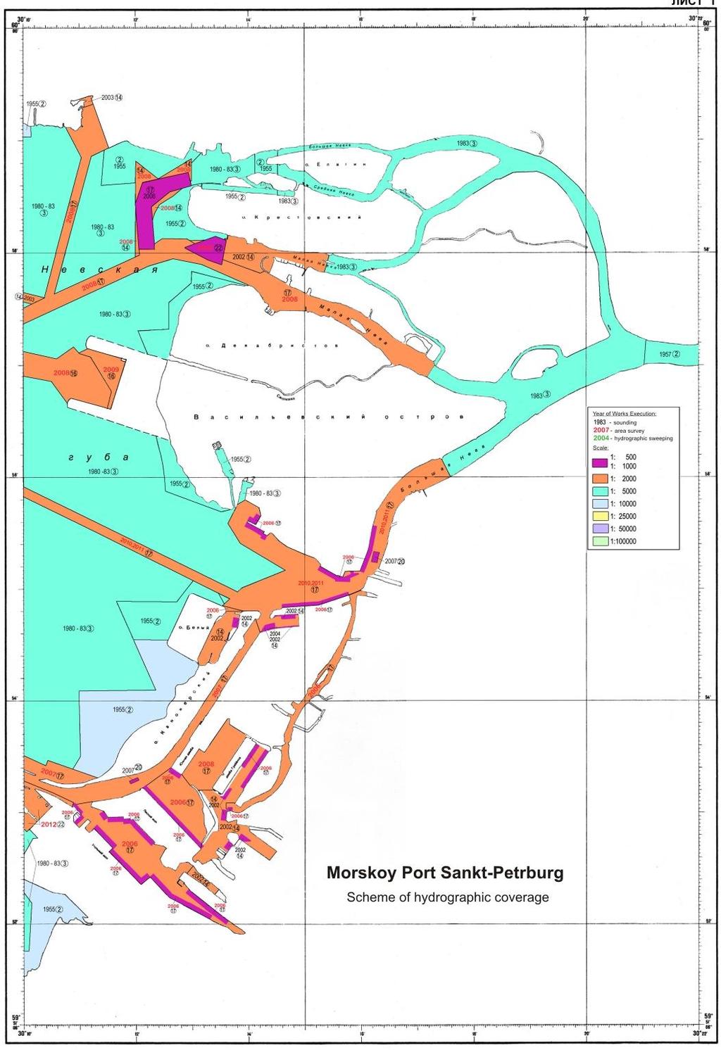
5 Fig. 1 5
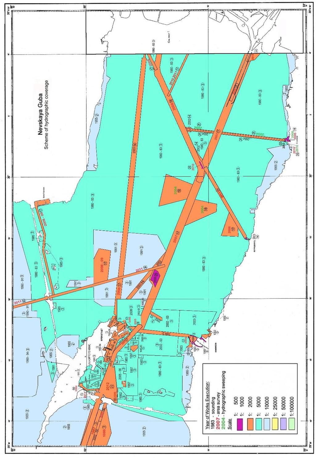
6 Fig. 2 6
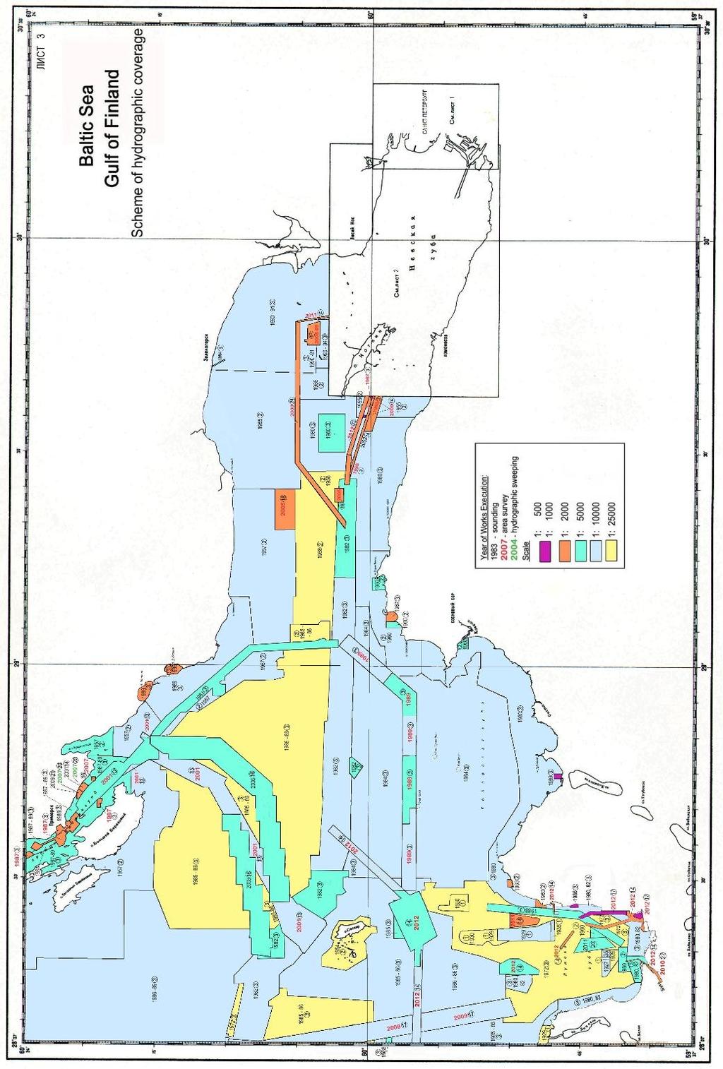
7 Fig. 3 7
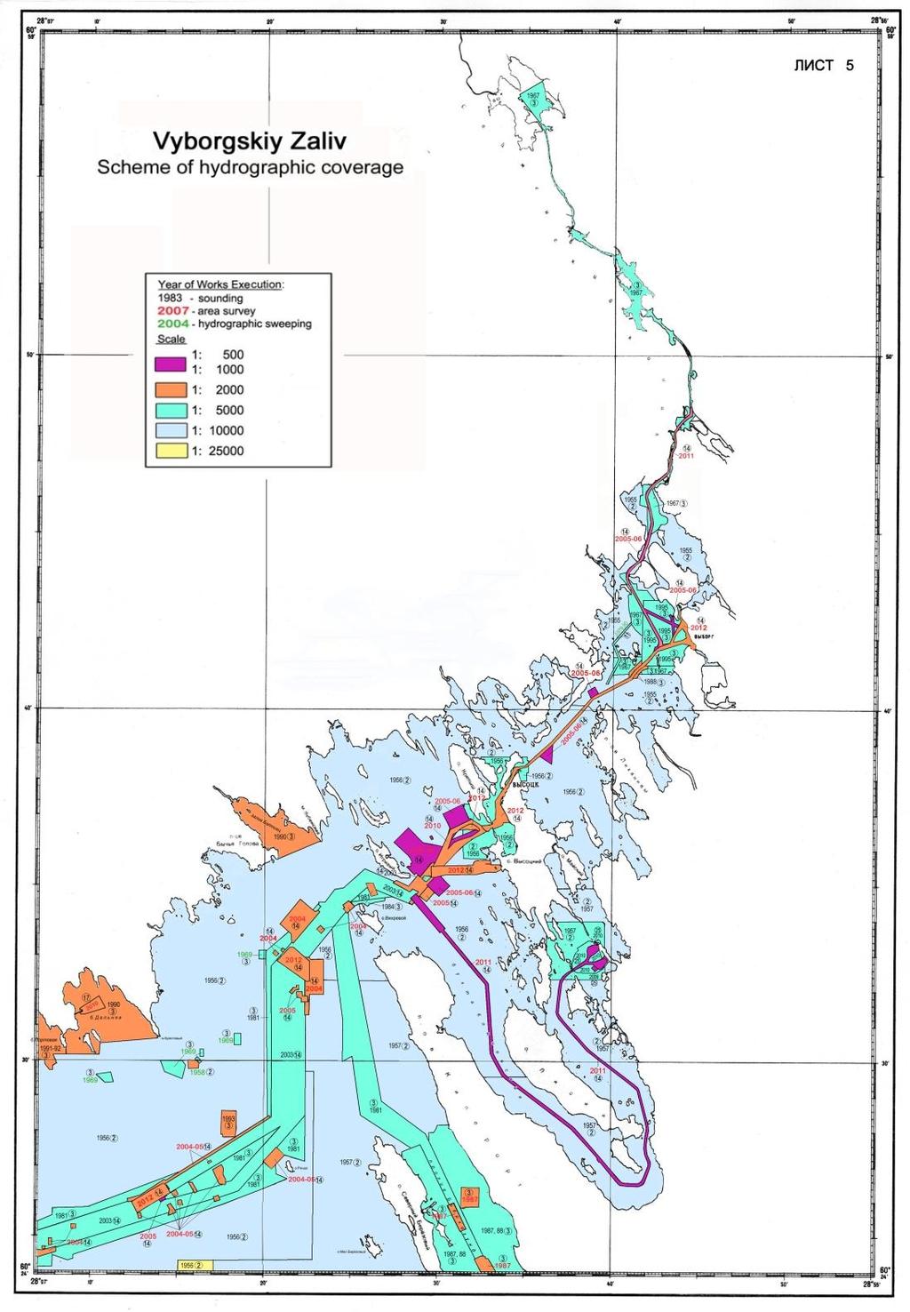
8 Fig. 4 8
9 New Technologies and/or Equipment For period since the last meeting of the Commission, new technologies and the equipment have not been used New Vessels For period since the last meeting of the Commission, new vessels have not been put into service. 3. New Charts and Updates 3.1. Electronic Navigational Charts List of new electronic navigational charts, No Cell No Chart Title Scale 1: 1 RU3NCJP9 2 RU4NEK11 Baltic Sea S Part. Russian-Lithuanian Boundary to Russian-Polish Boundary Baltic Sea S Part. Rybachiy Lighthouse to Zelenogradsk Table 2 Year of publishing RU5NTKP2 4 RU5NTKP3 5 RU5O1KO0 Baltic Sea. Gulf of Finland. Luzhskaya Inlet. Approaches to Port Ust'-Luga Baltic Sea. Gulf of Finland. Luzhskaya Inlet. Port Ust -Luga Baltic Sea Gulf of Finland. Dal'nyaya Bay
10 List of New Editions of Electronic Navigational Charts, No Cell No Chart Title Scale 1: 1 RU4NSKO0 2 RU4NTKO9 3 RU5NEK00 4 RU5NSKO0 Baltic Sea. Gulf of Finland. Luzhskaya Inlet Baltic Sea. Gulf of Finland. Luzhskaya Inlet to Ustinskyy Point Baltic Sea S Part. Port Pionerskiy Baltic Sea. Gulf of Finland. Luzhskaya Inlet. Approaches to Luga River Mouth Year of Publishing Table 3 Edition No 5 rd Edition 3 rd Edition 3 rd Edition 3 rd Edition 3.2. Method of ENC Distribution Merchandising of electronic navigational charts is carried out through the official distributor of cartographic products of Hydrographic Office of the Russian Federation in frames of the standard S-63.

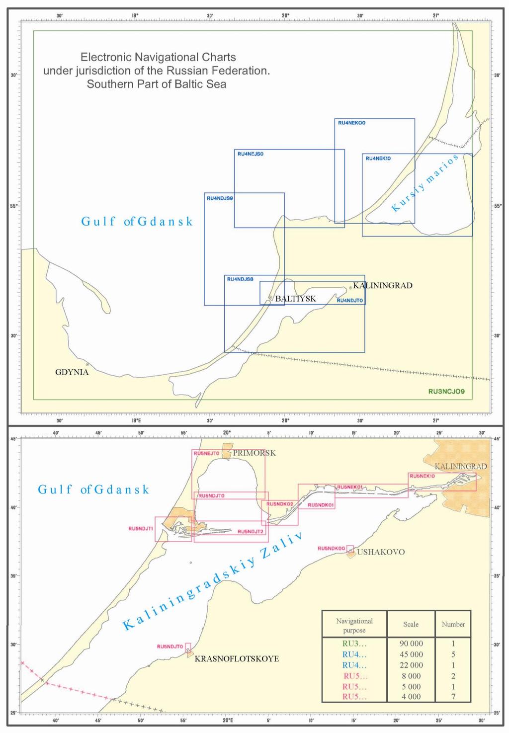
11 11 ENCs, January 2013 Fig. 5
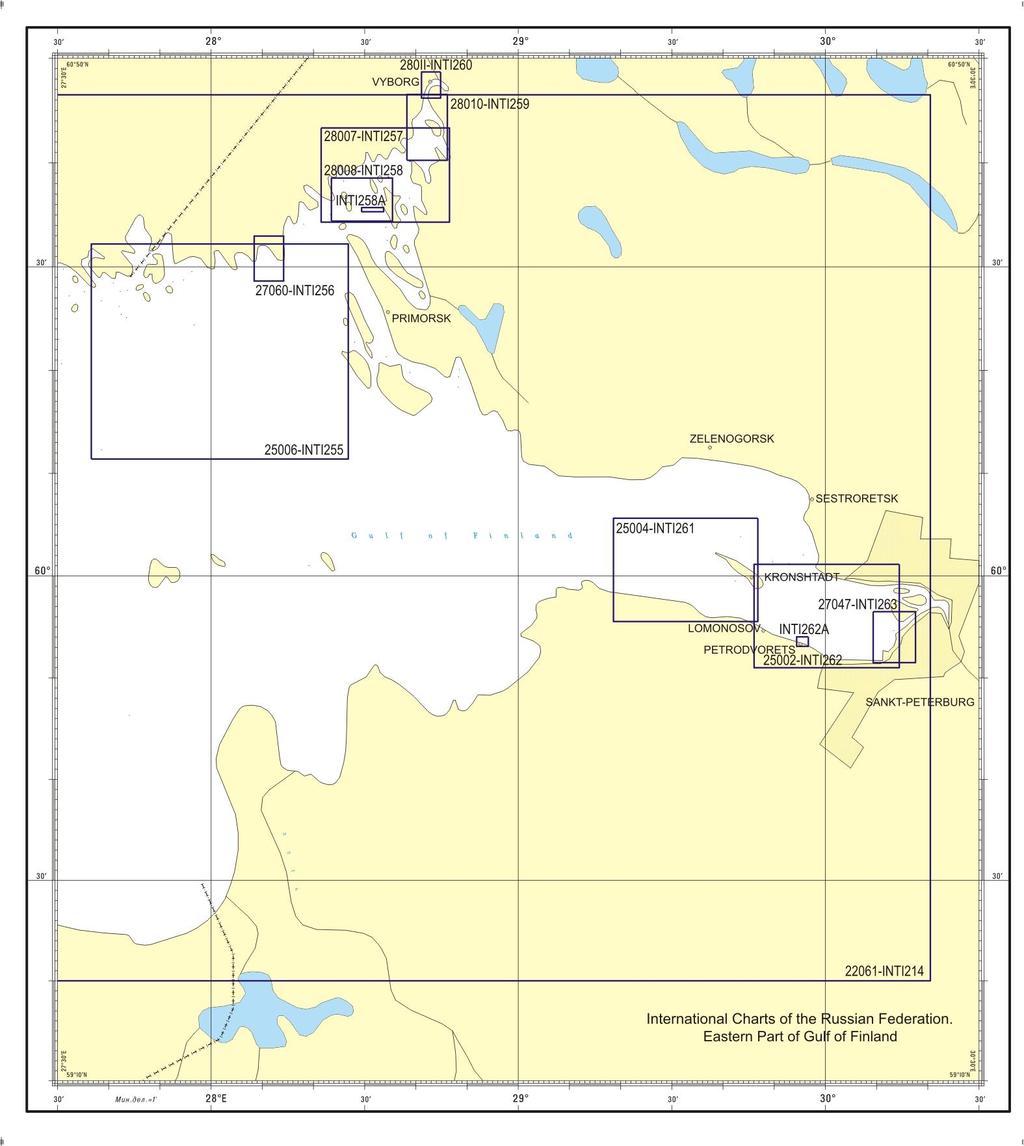
12 Fig. 6 12

13 13 New ENCs, 2013 Fig. 7

14 14 Fig Raster Navigational Charts (RNCs) DNO of the RF MD does not distribute RNCs International Charts To date, the DNO of the RF MD has fully performed its obligations to issue of International Charts on the waters of the Gulf of Finland and the South- Eastern Part of the Baltic Sea. In recent years, it only re-publishes these charts. In accordance with decision of BSHC, charts INT1216 and INT 1217 are transferred to the Republic of Latvia, and chart INT1215 will be re-published in the Republic of Estonia. The following is a complete list of International Charts on the area of responsibility of Russia as of June 1, 2013.
15 15 List of International Charts Edited under Frames of Baltic Sea Hydrographic Commission Table 4 No. Chart INT No. Chart Russian No. Chart Name Scale 1: Date of Publication Date of Printing Adopted Date of New Edition Baltic Sea. Gulf of Finland Western Part of Gulf of Finland Eastern Part of Gulf of Finland Baltic Sea. Gulf of Finland. Ostrov Rondo to Ostrov Sommers Bukhta Dal nyaya Approaches to Vysotsk and Vyborg Baltic Sea. Gulf of Finland.Povorotnyy Lighthouse to Ostrov Malyy Vysotskiy. Inset A. Approach Channel to Oil Terminal Lukoyl-II Baltic Sea. Vyborgskiy Zaliv. Approaches to Saymenskiy Kanal. Dubovyy Light-beacon to Ostrov Lavola. Baltic Sea. Vyborgskiy Zaliv. Approaches to Saymenskiy Kanal. Bukhta Zashchitnaya to Brusnichnoye Shluz Baltic Sea. Gulf of Finland. Kronshtadt to Krasnaya Gorka
16 Baltic Sea. Gulf of Finland. Sankt- Petersburg to Kronshtadt Maritime Port Sankt- Peterburg Baltic Sea. South Part. Approaches to Kaliningradskiy Morskoy Kanal Kaliningradskiy Morskoy Kanal Baltic Sea. South Part. Port Baltiysk. Entrance to Kaliningradskiy Morskoy Kanal Baltic Sea. South Part. Kaliningradskiy Morskoy Kanal. Picket No.24 to Povorot Komsomol skiy Baltic sea. Southern Part. Kaliningradskiy Maritime Canal. Povorot Komsomol skiy Baltic Sea. South Part. Kaliningradskiy Morskoy Kanal. Povorot Izhevskiy. Baltic Sea. Southern Part. Kaliningradskiy Morskoy Kanal. Gavan Vzmor ye to Reka Pregolya Mouth Baltic Sea. South Part. Kaliningradskiy Morskoy Kanal. Mouth of Reka Pregolya to Port Kaliningrad
17 Fig. 9 17

18 Fig
19 National Paper Charts DNO of the RF MD issued 79 nautical charts on waters of the Baltic Sea under jurisdiction of Russia: Gulf of Finland, Vyborgskiy Zaliv and Kaliningradskiy Zaliv. Scale row is shown in table 5. The collection is maintained up-to-date using correction and re-publishing of charts as new hydrographic data become available. Table 5 No National No. of chart Scale National INT 1: : : : : : and larger List of New National Paper Charts Published in Chart Name Scale 1: Date of Publication Date of Printing Mys Taran to Port Ustka Table 6 Estimated Date of New Printing Eastern Section of the Northern Route of Flood-Defence Bol shoy Kronshtadtskiy Reyd III qu Luzhskaya Guba Luzhskaya Guba. Approaches to Port Ust - Luga Luzhskaya Guba. Port Ust -Luga Southern Part of Bukhta Primorskaya Approaches to the Mouth of Reka Luga

20 Fig

21 Printing System of On-demand Charts In 2007, printing complex of on-demand charts was developed in Russia. The objectives which are pursued by its development include saving with reproduction of nautical charts by polygraphic method and efficient supply of consumers with up-to-date cartographic products. Test operation of printing system of on- demand charts was launched in 2010 (NtM No. 28 of 2010). Beginning from 2011, published nautical charts are distributed only by way of printing on- demand charts. At present, the base of on- demand charts contains more than 700 nautical charts. This base is supplemented monthly by new charts. Fig. 12
 All publications are supplied on a paper basis. 5. Maritime Safety Information (MSI) 5.1.")
22 22 4. New publications and updates 4.1. New Publications For period since the last meeting of the Commission, new publications have not been issued Updated Publications Issued publications are updated from NtMs of DNO of the RF MD Means of Supply (e.g. paper, digital) All publications are supplied on a paper basis. 5. Maritime Safety Information (MSI) 5.1. Existing Infrastructure for Transmission Within the framework of the World- Wide Navigational Warning Service (WWNWS), the Russian Federation collects and makes available to mariners information on changes in sailing conditions and regime of navigation, including: - for WWNWS Area 13 in the form of warnings, NAVAREA XIII; - for WWNWS Areas 20 and 21 in the form of warnings, NAVAREAs XX and XXI; - for broadcasting areas of coastal warnings in the form of Coastal Warnings for Areas of ARKHANGEL SK, ASTRAKHAN, VLADIVOSTOK, KALININGRAD, MURMANSK, NOVOROSSIYSK, PETERBURG, PETROPAVLOVSK, EAST (Eastern Part of the Northern Sea Route), WEST (Western Part of the Northern Sea Route).
23 Promulgation of Navigational Warnings in the Baltic Region The Russian Federation is one of the nine Coastal States of the Baltic Sea, serving as national coordinators with promulgation of maritime safety information in the Baltic Sea Area (Coordinator of the Sub-Area within the NAVAREA I is Sweden). MSI broadcasting is carried out by National Hydrographic Service for two areas of coastal warnings: - CW PETERBURG Area (Eastern Part of the Gulf of Finland); - CW KALININGRAD Area (South-Eastern Part of the Baltic Sea); Russia has no Baltic NAVTEX stations. Transmission of Russian CWs within NAVTEX System is performed: - for CW PETERBURG by Tallinn Station (Estonia); - for CW KALINGRAD by Gislövshammar Station (Sweden). Number of Announced Coastal Warnings for Three Years Table 7 CW Area CW PETERBURG CW KALININGRAD There are electronic versions of Notices to Mariners and NAVAREA Warning Bulletins at the official website of the Ministry of Defense of the Russian Federation in pdf format: 6. Standard S-55 The latest updates (Tables) Water Area of Russia km2 Area with depth 200m km2 Water Area of Gulf of Finland km2 Water Area of Southern Part of Baltic Sea km2
24 24 Table 8 Depth range Adequate survey % Repeated survey is needed % No systematic survey % Depths 200 m Depths 200 m Capacity-building No information to include in the report. 8. Oceanographic Activities No information to include in the report. 9. Other Activities No information to include in the report. 10. Conclusion The present report reflects activity results of the Hydrographic Service of the Russian Federation for the period since the last meeting of the Commission. Contacts: telephone/fax: fax: main@gunio.ru navarea13@gunio.ru website: (NtMs are available in English) address: 8, 11 Liniya, St.-Petersburg,
NATIONAL REPORT OF THE RUSSIAN FEDERATION
 DEPARTMENT OF NAVIGATION AND OCEANOGRAPHY MINISTRY OF DEFENSE OF THE RUSSIAN FEDERATION NATIONAL REPORT OF THE RUSSIAN FEDERATION 17-th MEETING of BALTIC SEA HYDROGRAPHIC COMMISSION Finland, Helsinki,
NATIONAL REPORT OF THE RUSSIAN FEDERATION
 DEPARTMENT OF NAVIGATION AND OCEANOGRAPHY, RUSSIAN FEDERATION MINISTRY OF DEFENСE NATIONAL REPORT OF THE RUSSIAN FEDERATION 21 TH MEETING OF BALTIC SEA HYDROGRAPHIC COMMISSION Republic of Lithuania, Klaipeda
HELLENIC NAVY HYDROGRAPHIC SERVICE. XVI th MEDITERRANEAN AND BLACK SEAS HYDROGRAPHIC COMMISSION NATIONAL REPORT OF GREECE
 HELLENIC NAVY HYDROGRAPHIC SERVICE XVI th MEDITERRANEAN AND BLACK SEAS HYDROGRAPHIC COMMISSION NATIONAL REPORT OF GREECE Odessa - Ukraine, 22-24 September 2009 1. Hydrographic Service: General Hellenic
National Report of Finland
 National Report of Finland [15 August 2012] Executive Summary This Report gives an overview of the main activities of the Finnish Hydrographic Office (FHO) since the previous BSHC 16 th Conference. The
National Report of the Russian Federation
 National Report of the Russian Federation The 8 th Conference of the 11-13 September 2018, Longyearbyen, Svalbard Submitted by: the Department of Navigation and Oceanography of the Ministry of Defense
MESO-AMERICAN AND CARIBBEAN HYDROGRAPHIC COMMISSION. National Report (October 2006) - Jamaica
 - Jamaica") MESO-AMERICAN AND CARIBBEAN HYDROGRAPHIC COMMISSION National Report (October 2006) - Jamaica 1. HYDROGRAPHIC OFFICE: Reorganization Jamaica is a member State of the IHO and the Meso-America and Caribbean
MESO-AMERICAN AND CARIBBEAN HYDROGRAPHIC COMMISSION National Report (October 2006) - Jamaica 1. HYDROGRAPHIC OFFICE: Reorganization Jamaica is a member State of the IHO and the Meso-America and Caribbean
Photo list of facilities built under the projects of CJSC "HT Morstroy" Design Institute in
 Photo list of facilities built under the projects of CJSC "HT Morstroy" Design Institute in 2000 2016 Construction as of March 31, 2016 2016 General Designer 2015 General Designer 2015 General Designer
National Report - Jamaica. 17 th MEETING OF THE MESO-AMERICAN AND CARIBBEAN HYDROGRAPHIC COMMISSION
 National Report - Jamaica 17 th MEETING OF THE MESO-AMERICAN AND CARIBBEAN HYDROGRAPHIC COMMISSION BELEM, BRAZIL DECEMBER 14 17, 2016 MESO-AMERICAN AND CARIBBEAN SEA HYDROGRAPHIC COMMISSION 17 th Meeting
THE HYDROGRAPHIC AND TOPOGRAPHIC BRIGADE OF THE SEYCHELLES COAST GUARD REPORT FOR 2008 SAIHC7-5.3I
 THE HYDROGRAPHIC AND TOPOGRAPHIC BRIGADE OF THE SEYCHELLES COAST GUARD REPORT FOR 2008 SAIHC7-5.3I CONTENT 1. GENERAL 2. S55 UPDATE 3. SURVEYS 4. NEW CHARTS & UPDATES 5. NEW PUBLICATIONS & UPDATES 6. MARITIME
National Report - Jamaica. 18 th MEETING OF THE MESO-AMERICAN AND CARIBBEAN HYDROGRAPHIC COMMISSION
 National Report - Jamaica 18 th MEETING OF THE MESO-AMERICAN AND CARIBBEAN HYDROGRAPHIC COMMISSION VARADERO, CUBA NOVEMBER 29-DECEMBER 2, 2017 MESO-AMERICAN AND CARIBBEAN SEA HYDROGRAPHIC COMMISSION 18
NATIONAL REPORT OF THE RUSSIAN FEDERATION
 DEPARTMENT OF NAVIGATION AND OCEANOGRAPHY OF THE MINISTRY OF DEFENSE OF THE RUSSIAN FEDERATION NATIONAL REPORT OF THE RUSSIAN FEDERATION The 5 th MEETING OF ARCTIC REGIONAL HYDROGRAPHIC COMMISSION Russian
NATIONAL REPORT OF GREECE
 HELLENIC NAVY HYDROGRAPHIC SERVICE 20 th Meeting of Mediterranean and Black Seas Hydrographic Commission (MBSHC) NATIONAL REPORT OF GREECE 4-6July 2017 Herceg Novi, Montenegro 1. Hydrographic Service:
WWNWS 6/3/2/XIV Meeting 6 27 July 2014 Agenda Item 3.2.XIV. MSI Self Assessment NAVAREA XIV. Submitted by New Zealand SUMMARY
 WWNWS WWNWS 6/3/2/XIV Meeting 6 27 July 2014 Agenda Item 3.2.XIV MSI Self Assessment NAVAREA XIV Submitted by New Zealand SUMMARY Executive Summary: Overview of activities undertaken in NAVAREA XIV since
XVII MESO AMERICAN AND CARIBBEAN SEA HYDROGRAPHIC COMMISSION MEETING, BELEM, BRASIL
 XVII MESO AMERICAN AND CARIBBEAN SEA HYDROGRAPHIC COMMISSION MEETING, BELEM, BRASIL 2016 2. HYDROGRAPHIC SURVEYS NEW HYDROGRAPHIC SURVEYS WITH CARTOGRAPHIC PURPOSES EQUIPMENT Single beam echosounders
WWNWS9/3/2/XIV Meeting 9 14 August 2017 Agenda Item 3.2. MSI Self Assessment NAVAREA XIV. Submitted by New Zealand SUMMARY
 WWNWS WWNWS9/3/2/XIV Meeting 9 14 August 2017 Agenda Item 3.2 MSI Self Assessment NAVAREA XIV Submitted by New Zealand SUMMARY Executive Summary: Overview of activities undertaken in NAVAREA XIV since
NEW ZEALAND NATIONAL REPORT
 NEW ZEALAND NATIONAL REPORT TO THE 11 th IHO HYDROGRAPHIC COMMISSION ON ANTARCTICA (HCA) Hobart, Tasmania, AUSTRALIA 5 th 7 th October 2011 1. Land Information New Zealand () 1.1 The National Hydrographer
National Report of Finland
 National Report of 1. Finnish Hydrographic Office The Finnish Hydrographic Office (FHO) is responsible for nautical charting over the Finnish sea area and the most important inland water bodies. This covers
MESO AMERICAN AND CARIBBEAN SEA HYDROGRAPHIC COMMISSION 18 th Meeting Varadero, Cuba (27 November - 02 December 2017) NATIONAL REPORT BRAZIL
 NATIONAL REPORT BRAZIL") Pag. 1 de 5 MESO AMERICAN AND CARIBBEAN SEA HYDROGRAPHIC COMMISSION 18 th Meeting Varadero, Cuba (27 November - 02 December 2017) NATIONAL REPORT BRAZIL 1. Hydrographic Office / Service: Directorate of
Pag. 1 de 5 MESO AMERICAN AND CARIBBEAN SEA HYDROGRAPHIC COMMISSION 18 th Meeting Varadero, Cuba (27 November - 02 December 2017) NATIONAL REPORT BRAZIL 1. Hydrographic Office / Service: Directorate of
REPUBLIC OF SOUTH AFRICA
 REPUBLIC OF SOUTH AFRICA SAN HYDROGRAPHIC OFFICE NATIONAL REPORT TO THE IHO HYDROGRAPHIC COMMISSION ON ANTARCTICA (HCA) 11 TH MEETING, HOBART, AUSTRALIA 05-07 OCTOBER 2011 2 11 TH HCA MEETING REPORT BY
MESO AMERICAN AND CARIBBEAN SEA HYDROGRAPHIC COMMISSION 15 th Meeting - Manzanillo, Mexico (10-13 December 2014) NATIONAL REPORT BRAZIL
 NATIONAL REPORT BRAZIL") Pag. 1 de 6 MESO AMERICAN AND CARIBBEAN SEA HYDROGRAPHIC COMMISSION 15 th Meeting - Manzanillo, Mexico (10-13 December 2014) NATIONAL REPORT BRAZIL 1.Hydrographic Office / Service: Directorate of Hydrography
Pag. 1 de 6 MESO AMERICAN AND CARIBBEAN SEA HYDROGRAPHIC COMMISSION 15 th Meeting - Manzanillo, Mexico (10-13 December 2014) NATIONAL REPORT BRAZIL 1.Hydrographic Office / Service: Directorate of Hydrography
Increasing Maritime Transport, Impacts on Maritime Safety
 Increasing Maritime Transport, Impacts on Maritime Safety Int. Seminar on Baltic Maritime Safety Co operation St. Petersburg, Russia, 5. 6.June. 2007 Jorma Rytkönen Contents Maritime Safety Trends and
WWNWS 6/3/2/X/Rev.1 Meeting 6 16 July 2014 Agenda Item 3.2.X. MSI Self Assessment NAVAREA X
 WWNWS WWNWS 6/3/2/X/Rev.1 Meeting 6 16 July 2014 Agenda Item 3.2.X MSI Self Assessment NAVAREA X Submitted by Australia (Australian Maritime Safety Authority) SUMMARY Executive Summary: Annual report by
XVII MESO AMERICAN AND CARIBBEAN SEA HYDROGRAPHIC COMMISSION MEETING, BELEM, BRASIL
 XVII MESO AMERICAN AND CARIBBEAN SEA HYDROGRAPHIC COMMISSION MEETING, BELEM, BRASIL 2016 2. HYDROGRAPHIC SURVEYS NEW HYDROGRAPHIC SURVEYS WITH CARTOGRAPHIC PURPOSES EQUIPMENT Single beam echosounders Single
BANGLADESH NATIONAL HYDROGRAPHIC REPORT FOR THE 13 TH NIOHC MEETING
 BANGLADESH NATIONAL HYDROGRAPHIC REPORT FOR THE 13 TH NIOHC MEETING YANGON, MYANMAR 19-22 FEBRUARY 2013 1 CONTENTS 1. Hydrographic Office 2. Surveys 3. New Charts & Updates 4. New Publications & Updates
22 nd BSHC Conference NATIONAL REPORT OF POLAND
 22 nd BSHC Conference NATIONAL REPORT OF August 2017 Executive summary This report summarizes activities of the Hydrographic Office/Service in the field of hydrography since the previous Baltic Sea Hydrographic
HELLENIC NAVY HYDROGRAPHIC SERVICE. XV th MEDITERRANEAN AND BLACK SEAS HYDROGRAPHIC COMMISSION CONTRIBUTION OF GREECE
 HELLENIC NAVY HYDROGRAPHIC SERVICE XV th MEDITERRANEAN AND BLACK SEAS HYDROGRAPHIC COMMISSION CONTRIBUTION OF GREECE Malta, 22-24 October 2007 1. Hydrographic Office: Hellenic Navy Hydrographic Service
NEW ZEALAND NATIONAL REPORT
 NEW ZEALAND NATIONAL REPORT TO THE 11 TH SOUTH WEST PACIFIC HYDROGRAPHIC COMMISSION (SWPHC) MEETING Brisbane, AUSTRALIA 15 TH 16 TH February 2012 1. Land Information New Zealand (LINZ) 1.1 The National
BARBADOS NATIONAL REPORT
 BARBADOS NATIONAL REPORT TO THE 10 TH MEETING OF THE MESO-AMERICA AND CARIBBEAN HYDROGRAPHIC COMMISSION BRIDGETOWN, BARBADOS 3 RD 6 TH NOVEMBER 2009 HYDROGRAPHIC OFFICE: Establishment Barbados is an associate
Baltic Port Market. BPO Conference Riga, RECIENT FACTS & FIGURES. dr Maciej Matczak
 Baltic Port Market RECIENT FACTS & FIGURES BPO Conference Riga, 3-4.09.2015 Schedule TOTAL CARGO TURNOVER Trends of the last decade 2005-2014 First half of 2015 preliminary results MAIN TYPES OF CARGO
Baltic Sea Hydrographic Commission, Bathymetric Database and the MONALISA project. - with co-financing from EU TEN-T SJÖFARTSVERKET
 SJÖFARTSVERKET Baltic Sea Hydrographic Commission, Presentation vid dialogmöte Kommunikationer för tillväxt Centerpartiet Östergötland, 25 oktober 2011 Magnus Sundström Bathymetric Database and the MONALISA
MSI Self Assessment NAVAREA VII CPRNW VII Submitted by: South Africa
 MSI Self Assessment NAVAREA VII CPRNW9-3.2.1-VII Submitted by: South Africa 1. Action Required: The Commissions attention is drawn to paragraph 11 below. 2. Background: The Co-coordinator of NAVAREA VII
ROSMORPORT perspectives on Clean Shipping in the Baltic Sea
 ROSMORPORT perspectives on Clean Shipping in the Baltic Sea ILIA SIDLO Kaliningrad branch of FSUE ROSMORPORT CLEANSHIP Project Final Conference in Trelleborg 2-3 September 2013 Key topics Reduce of air
MEDITERRANEAN AND BLACK SEAS HYDROGRAPHIC COMMISSION CONTRIBUTION BY CROATIA
 MEDITERRANEAN AND BLACK SEAS HYDROGRAPHIC COMMISSION CONTRIBUTION BY CROATIA MALTA 22-24 October 2007 CONTENTS... 1 1. HYDROGRAPHIC OFFICE... 2 2. SURVEYS... 2 2.1. Survey status... 2 2.2. New technologies...
DEVELOPMENT OF TRAFFIC VOLUMES IN BALTIC SEA
 DEVELOPMENT OF TRAFFIC VOLUMES IN BALTIC SEA Tõnis Segerkrantz WINTER PERIOD PORT CALL DATA Real port call statistics were acquired from Finnish, Estonian and Russian maritime administrations and port
The ice season
 The ice season 2005-2006 Author: Jouni Vainio 1 Co-authors: Simo Kalliosaari 1, Natalija Schmelzer 2, Torbjörn Grafström 3, Inga Dailidiene 4, Evgeni Komissarov 5 and P. Soloshchuk 5 Key Message The ice
USCHC39-03C. Paris, May 12 th 2016 N 002 SHOM/DMI/REX/NP FRANCE SELF-ASSESSMENT TO THE 39 TH USCHC CONFERENCE
 USCHC39-03C SERVICE HYDROGRAPHIQUE ET OCEANOGRAPHIQUE DE LA MARINE DIRECTION DES MISSIONS INSTITUTIONNELLES ET DES RELATIONS INTERNATIONALES Dossier suivi par IETA Eric Langlois Head of the external relations
MSI Self Assessment NAVAREA VII. Submitted by: South Africa SUMMARY
 MSI Self Assessment NAVAREA VII 1 SAIHC10-5.2 Submitted by: South Africa SUMMARY 1. Background. The Coordinator of NAVAREA VII, in conjunction with the South African Meteorological Service, promulgates
REPORT BY THE NAVAL HYDROGRAPHIC SERVICE
 IHO Hydrographic Committee on Antarctica (HCA) 13 th Meeting, Cádiz, Spain, 3-5 December 2013 REPORT BY THE NAVAL HYDROGRAPHIC SERVICE MINISTERIO DE DEFENSA SERVICIO DE HIDROGRAFIA NAVAL Tel.: (54-11)
IHO Capacity Building in the South West Pacific Region NZ Perspective. Adam Greenland National Hydrographer Land Information New Zealand
 IHO Capacity Building in the South West Pacific Region NZ Perspective Adam Greenland National Hydrographer Land Information New Zealand Overview Introduction to Capacity Building IHO Strategy, Plan and
BRISK Sub-regional risk of spill of oil and hazardous substances in the Baltic Sea
 BRISK Sub-regional risk of spill of oil and hazardous substances in the Baltic Sea Part-financed by the European Union Photo: Nikolay Vlasov / HELCOM Maritime traffic in the Baltic The Baltic Sea today
REPUBLIC OF MOZAMBIQUE
 SAIHC14-5.4F REPUBLIC OF MOZAMBIQUE INSTITUTO NACIONAL DE HIDROGRAFIA E NAVEGAÇÃO NATIONAL REPORT TO THE 14 th SOUTHERN AFRICA AND ISLANDS HYDROGRAPHIC COMMISSION CONFERENCE Saint-Gilles La Réunion 6 th
SAN HYDROGRAPHIC OFFICE NATIONAL REPORT to the 14 TH SOUTHERN AFRICA AND ISLANDS HYDROGRAPHIC COMMISSION CONFERENCE (SAIHC) 6-8 September 2017
 6-8 September 2017") Inter-Regional Coordinating Committee SAN HYDROGRAPHIC OFFICE NATIONAL REPORT to the 14 TH SOUTHERN AFRICA AND ISLANDS HYDROGRAPHIC COMMISSION CONFERENCE (SAIHC) 6-8 September 2017 Principal functions:
Inter-Regional Coordinating Committee SAN HYDROGRAPHIC OFFICE NATIONAL REPORT to the 14 TH SOUTHERN AFRICA AND ISLANDS HYDROGRAPHIC COMMISSION CONFERENCE (SAIHC) 6-8 September 2017 Principal functions:
EGYPTIAN HYDROGRAPHIC DEPARTMENT ENHD. The ENHD following by the chain of command the Egyptian Naval HQ.
 ENHD gvt 4/7/2015 1 ENHD The ENHD following by the chain of command the Egyptian Naval HQ. Considered one of the oldest and the most experienced hydrographic office in the region (since 1920). ENHD is
IHO SOUTH WEST PACIFIC HYDROGRAPHIC COMMISSION (SWPHC)
") IHO SOUTH WEST PACIFIC HYDROGRAPHIC COMMISSION (SWPHC) 9 th Meeting Port Moresby, Papua New Guinea, 10-11 March 2009 Australian Hydrographic Service National Report 1 9 th SOUTH WEST PACIFIC HYDROGRAPHIC
IHO SOUTH WEST PACIFIC HYDROGRAPHIC COMMISSION (SWPHC) 9 th Meeting Port Moresby, Papua New Guinea, 10-11 March 2009 Australian Hydrographic Service National Report 1 9 th SOUTH WEST PACIFIC HYDROGRAPHIC
12 th Meeting of the South West Pacific Hydrographic Commission (SWPHC)
") 12 th Meeting of the South West Pacific Hydrographic Commission (SWPHC) National Report New Zealand Adam Greenland National Hydrographer New Zealand Hydrographic Authority Port Villa, Vanuatu, 12 th 14
12 th Meeting of the South West Pacific Hydrographic Commission (SWPHC) National Report New Zealand Adam Greenland National Hydrographer New Zealand Hydrographic Authority Port Villa, Vanuatu, 12 th 14
ALL SHIPOWNERS, OPERATORS, MASTERS AND OFFICERS OF MERCHANT SHIPS, AND RECOGNIZED ORGANIZATIONS
 REPUBLIC OF Marine Notice THE MARSHALL ISLANDS No. 7-041-6 OFFICE OF THE MARITIME ADMINISTRATOR Rev. 3/14 TO: SUBJECT: ALL SHIPOWNERS, OPERATORS, MASTERS AND OFFICERS OF MERCHANT SHIPS, AND RECOGNIZED
WWNWS3/3/2-VI Meeting 3 17 August MSI Self Assessment NAVAREA VI SUMMARY
 WWNWS WWNWS3/3/2-VI Meeting 3 17 August 2011 MSI Self Assessment NAVAREA VI Submitted by ARGENTINA SUMMARY Executive Summary: Overview of activities undertaken within NAVAREA VI since WWNWS2 Action to
Ufs. No Notices to Mariners, SWEDEN Swedish Maritime Administration.
 Ufs No 582 2016-01-21 Notices to Mariners, SWEDEN Swedish Maritime Administration Editorial office Swedish Maritime Administration Ufs 601 78 NORRKÖPING Sweden tel: 0771 630 605 e-mail: ufs@sjofartsverket.se
Dalian VTS Guide for Users
 Dalian VTS Guide for Users 3 rd Edition DALIAN MARITIME SAFETY ADMINISTRATION OF P.R.CHINA DALIAN VESSEL TRAFFIC SERVICE CENTER Introduction The aim of this Guide is to provide vessel traffic service users
REPUBLIC OF MOZAMBIQUE NATIONAL REPORT
 REPUBLIC OF MOZAMBIQUE INSTITUTO NACIONAL DE HIDROGRAFIA E NAVEGAÇÃO NATIONAL INSTITUTE OF HYDROGRAPHY AND NAVIGATION (INAHINA) NATIONAL REPORT TO THE 8th SOUTHERN AFRICA AND ISLANDS HYDROGRAPHIC COMMISSION
Baltic Marine Environment Protection Commission
 Baltic Marine Environment Protection Commission Group of Experts on Safety of Navigation Copenhagen, Denmark, 3 December 2014 SAFE NAV 5-2014 Document title Revision of HELCOM Recommendation 25/7 Safety
NATIONAL REPORT OF THE RUSSIAN FEDERATION
 DEPARTMENT OF NAVIGATION AND OCEANOGRAPHY OF THE MINISTRY OF DEFENSE OF THE RUSSIAN FEDERATION NATIONAL REPORT OF THE RUSSIAN FEDERATION The 20 th CONFERENCE of MEDITERRANEAN and BLACK SEAS HYDROGRAPHIC
PART 1. EXECUTIVE SUMMARY. English Translation of the Russian Original
 REVISION OF THE PARTIAL SUBMISSION OF THE RUSSIAN FEDERATION TO THE COMMISSION ON THE LIMITS OF THE CONTINENTAL SHELF RELATED TO THE CONTINENTAL SHELF IN THE SEA OF OKHOTSK PART 1. EXECUTIVE SUMMARY English
PORT OF HELSINKI ALL OF FINLAND WITHIN YOUR REACH
 PORT OF HELSINKI ALL OF FINLAND WITHIN YOUR REACH PORT OF THE ENTIRE FINLAND One of the strengths of the Port of Helsinki is its excellent location at the heart of Finnish production, population and consumption.
Port of Tallinn Estonia s Biggest Maritime Gateway
 Port of Tallinn Estonia s Biggest Maritime Gateway Margus Vihman Chief Commercial Officer/ Member of the Management Board Organization The company in a nutshell State-owned limited liability company Port
Innovation based development of Klaipeda Port technologies
 Discover a proven way! Innovation based development of Klaipeda Port technologies Mr. Artūras Drungilas Marketing and Corporate Affairs Director Klaipeda State Seaport Authority PortofKlaipeda.lt 1 Management
[47/18] ADMIRALTY Charts affected by the Publication List. denotes chart available in the ADMIRALTY Raster Chart Service series. 1.
![[47/18] ADMIRALTY Charts affected by the Publication List. denotes chart available in the ADMIRALTY Raster Chart Service series. 1.](/thumbs/92/110112707.jpg "[47/18] ADMIRALTY Charts affected by the Publication List. denotes chart available in the ADMIRALTY Raster Chart Service series. 1.") ADMIRALTY Charts affected by the Publication List [47/18] ADMIRALTY Charts International Charts 87 INT 1156 89 INT 1195 91 INT 1200 142 INT 1206 272 INT 1238 541 INT 1416 774 INT 1642 798 INT 1643 820
ADMIRALTY Charts affected by the Publication List [47/18] ADMIRALTY Charts International Charts 87 INT 1156 89 INT 1195 91 INT 1200 142 INT 1206 272 INT 1238 541 INT 1416 774 INT 1642 798 INT 1643 820
NATIONAL REPORT OF UKRAINE TO 19th MEETING OF THE MEDITERRANEAN AND BLACK SEAS HYDROGRAPHIC COMMISSION (MBSHC)
") NATIONAL REPORT OF UKRAINE TO 19th MEETING OF THE MEDITERRANEAN AND BLACK SEAS HYDROGRAPHIC COMMISSION (MBSHC) 1. Hydrographic Office/Service a. General The State Hydrographic Service of Ukraine (SHSU)
NATIONAL REPORT OF UKRAINE TO 19th MEETING OF THE MEDITERRANEAN AND BLACK SEAS HYDROGRAPHIC COMMISSION (MBSHC) 1. Hydrographic Office/Service a. General The State Hydrographic Service of Ukraine (SHSU)
Discover a proven way! PORT of KLAIPEDA. Klaipeda Port Extensive Business Opportunities Artūras Drungilas. Marketing and Corporate Affairs Director
 Discover a proven way! PORT of KLAIPEDA Klaipeda Port Extensive Business Opportunities Artūras Drungilas Marketing and Corporate Affairs Director Klaipeda Port Advantages of Klaipėda Port Convenient geographical
ANNEX G TO EAtHC WEST AFRICA ACTION TEAM REPORT DECEMBER 2002 COUNTRY REPORT: SENEGAL
 ANNEX G TO EAtHC WEST AFRICA ACTION TEAM REPORT DECEMBER 2002 COUNTRY REPORT: SENEGAL INTRODUCTION. 1. RHC Involvement. Senegal is not a member of IHO, but is an associate member of the EAtHC and has participated
 16 March 2004 HELCOM RECOMMENDATION 25/7 on the SAFETY OF WINTER NAVIGATION IN THE BALTIC SEA AREA having regard to Article 13, Paragraph b) of the Helsinki Convention was adopted on 2 March 2004 in Helsinki
Ufs. No Notices to Mariners, SWEDEN Swedish Maritime Administration.
 Ufs No 730 2018-11-22 Notices to Mariners, SWEDEN Swedish Maritime Administration Editorial office Swedish Maritime Administration Ufs 601 78 NORRKÖPING Sweden tel: 0771 630 605 e-mail: ufs@sjofartsverket.se
Ufs. No Notices to Mariners, SWEDEN Swedish Maritime Administration.
 Ufs No 687 2018-01-25 Notices to Mariners, SWEDEN Swedish Maritime Administration Editorial office Swedish Maritime Administration Ufs 601 78 NORRKÖPING Sweden tel: 0771 630 605 e-mail: ufs@sjofartsverket.se
Solomon Islands Maritime Safety Administration
 SI M SA Solomon Islands Maritime Safety Administration Solomon Islands Government SOLOMON ISLANDS HYDROGRAPHIC UNIT National Report for the 13 th SOUTH WEST PACIFIC HYDROGRAPHIC COMMISSION MEETING RAROTONGA,
French national report to the 11 th meeting of the Meso-American
 Saint-Mandé, 28 th October 2010 N 162 SHOM/DSPRE/NP SERVICE HYDROGRAPHIQUE ET OCEANOGRAPHIQUE DE LA MARINE Directorate of Policy, Plans & External Relations Dossier suivi par : IETA Céline Roux : 33 1
[51/18] ADMIRALTY Charts affected by the Publication List. denotes chart available in the ADMIRALTY Raster Chart Service series. 1.
![[51/18] ADMIRALTY Charts affected by the Publication List. denotes chart available in the ADMIRALTY Raster Chart Service series. 1.](/thumbs/88/114932417.jpg "[51/18] ADMIRALTY Charts affected by the Publication List. denotes chart available in the ADMIRALTY Raster Chart Service series. 1.") ADMIRALTY Charts affected by the Publication List [51/18] ADMIRALTY Charts International Charts 139 INT 1176 809 INT 1201 924 INT 1288 946 INT 4184 1042 1250 ADMIRALTY Publications 1286 1480 NP 7A 1749
ADMIRALTY Charts affected by the Publication List [51/18] ADMIRALTY Charts International Charts 139 INT 1176 809 INT 1201 924 INT 1288 946 INT 4184 1042 1250 ADMIRALTY Publications 1286 1480 NP 7A 1749
FIG Congress 2010 Facing the Challenges Building the Capacity Sydney, Australia, April
 The Challenge of Hydrographic Surveying & Charting the Antarctic FIG Congress, Sydney, 11-16 April 2010 The need for accurate surveying & charting Vessel size & traffic; environmental protection; safety
FSUE ROSMORPORT CONSTRUCTION OF THE INTERNATIONAL MARINE TERMINAL WITH YACHT MARINA IN THE CITY OF PIONERSKY, KALININGRAD REGION
 FSUE ROSMORPORT CONSTRUCTION OF THE INTERNATIONAL MARINE TERMINAL WITH YACHT MARINA IN THE CITY OF PIONERSKY, KALININGRAD REGION Situated in the Northern part of the Kaliningrad peninsula, in the middle
Sava Commission Activities. KICK-OFF MEETING DANTE, February 17, 2017, Budapest
 Sava Commission Activities KICK-OFF MEETING DANTE, February 17, 2017, Budapest 1 Establishment of the ISRBC 2 Decay of SFRY a challenge to WRM in the Sava river basin Sava river used to be the biggest
HELSINKI COMMISSION HELCOM TRANSIT ROUTE EWG 13/2008 Expert Working Group on Transit Routeing 13th Meeting Helsinki, Finland, 7-8 October 2008
 HELSINKI COMMISSION HELCOM TRANSIT ROUTE EWG 13/2008 Expert Working Group on Transit Routeing 13th Meeting Helsinki, Finland, 7-8 October 2008 Agenda Item 2 Overview of the current situation/follow up
Floating Docks & Special Projects. Reference list
 Floating Docks & Special Projects Reference list Atomflot Floating Dock Customer: Unitary enterprise Atomflot, Rosatom cooperation, Russia Location: Murmansk, Russia Floating dock has a carrying capacity
Investment possibilities of municipal formation KINGISEPP MUNICIPAL DISTRICT. This project is funded by the European Union
 Investment possibilities of municipal formation KINGISEPP MUNICIPAL DISTRICT This project is funded by the European Union Kingisepp municipal district is situated in the South-West of Leningrad Region.
The Polar Code and the Canadian Arctic
 The Polar Code and the Canadian Marie Hélène Roy Transport Canada, Marine Safety and Security E Navigation Underway (North America) St. John s NF, October 17 th, 2017 Overview 1. Overview of Canada s Marine
REPORT BY THE NAVAL HYDROGRAPHIC SERVICE
 IHO Hydrographic Committee on Antarctica (HCA) 15th Meeting, Niteroi, Brazil 26-28 June 2018 REPORT BY THE NAVAL HYDROGRAPHIC SERVICE MINISTERIO DE DEFENSA SERVICIO DE HIDROGRAFIA NAVAL Tel.: (54-11) 4301-0061/67
Ufs. No Notices to Mariners, SWEDEN Swedish Maritime Administration.
 Ufs No 587 2016-02-25 Notices to Mariners, SWEDEN Swedish Maritime Administration Editorial office Swedish Maritime Administration Ufs 601 78 NORRKÖPING Sweden tel: 0771 630 605 e-mail: ufs@sjofartsverket.se
BALTIC ICEBREAKING MANAGEMENT. Baltic Sea Icebreaking Report
 BALTIC ICEBREAKING MANAGEMENT Baltic Sea Icebreaking Report 2006-2007 Table of contents FOREWORD...3 1. Short history of the Baltic Icebreaking Management...4 2. Overview of the icebreaking season (2006-2007)
Baltic Marine Environment Protection Commission
 Baltic Marine Environment Protection Commission Revised HELCOM RECOMMENDATION 25/7 Adopted 2 March 2004 having regard to Article 13, Paragraph b) of the Helsinki Convention Revised 4 March 2015 and 10
Tour of Finland s Maritime Community
 Tour of Finland s Maritime Community Ports of Vuosaari, Kotka, and Turku Saimaa Canal Tallinn, Estonia September 7-12, 2008 Tour Participants Dr. Richard Stewart, Co-Director Stacey Carlson, Associate
1. Hydrographic Office: General,
 MARINE NATIONALE Saint-Mandé, the 12 th of February 2007 N 67 SHOM/EG/NP SERVICE HYDROGRAPHIQUE ET OCEANOGRAPHIQUE DE LA MARINE Bureau études générales Dossier suivi par ICETA Yves Guillam : 01 53 66 97
Ufs. No Notices to Mariners, SWEDEN Swedish Maritime Administration.
 Ufs No 648 2017-04-27 Notices to Mariners, SWEDEN Swedish Maritime Administration Editorial office Swedish Maritime Administration Ufs 601 78 NORRKÖPING Sweden tel: 0771 630 605 e-mail: ufs@sjofartsverket.se
Central and local government's efforts in Russian Federation
 Maritime State University Central and local government's efforts in Russian Federation Presented by Ml FP of Russia SERGEY MONINETS 19-20 September 2017, Toyama, Japan 1 ML Sources # Sea-based ML Source
CHART SPECIFICATIONS OF THE IHO (S-4) AND SYMBOLS, ABBREVIATIONS AND TERMS USED ON CHARTS (INT1) Small Craft (Leisure) Facilities Symbols
 AND SYMBOLS, ABBREVIATIONS AND TERMS USED ON CHARTS (INT1) Small Craft (Leisure) Facilities Symbols") IHB File No. S3/4405 CIRCULAR LETTER 71/2010 3 November 2010 CHART SPECIFICATIONS OF THE IHO (S-4) AND SYMBOLS, ABBREVIATIONS AND TERMS USED ON CHARTS (INT1) Small Craft (Leisure) Facilities Symbols References:
IHB File No. S3/4405 CIRCULAR LETTER 71/2010 3 November 2010 CHART SPECIFICATIONS OF THE IHO (S-4) AND SYMBOLS, ABBREVIATIONS AND TERMS USED ON CHARTS (INT1) Small Craft (Leisure) Facilities Symbols References:
Economic and Social Council
 UNITED NATIONS E Economic and Social Council Distr. RESTRICTED 8 January 1997 Original: ENGLISH ECONOMIC COMMISSION FOR EUROPE COMMITTEE ON THE DEVELOPMENT OF TRADE Working Party on Facilitation of International
UNITED KINGDOM NATIONAL REPORT
 UNITED KINGDOM NATIONAL REPORT TO THE 10 TH MEETING OF THE SOUTH WEST PACIFIC HYDROGRAPHIC COMMISSION Honiara, Solomon Islands 9 th 10 th November 2010 NOTE: This report supplements the UK Generic National
The total NL responsibility area is divided in four categories, listed in Table 1. Cat m Harbours and approaches every 4 years
 MACHC 1703.Q NATIONAL REPORTS FROM THE NETHERLANDS TO THE MACHC17 Reference: IHO Resolution 2/1997 as amended Executive summary Satisfactory status for surveying and nautical charting in the MACHC area.
IHO Capacity Building Programme. The State of Hydrography and Nautical Charting in Montenegro
 IHO Capacity Building Programme The State of Hydrography and Nautical Charting in Montenegro November 2016 Contents Contents... 2 Abbreviations... 3 1. Introduction... 4 2. IHO Technical Visit... 4 3.
NEW ZEALAND TEMPORARY AND PRELIMINARY NOTICES IN FORCE (NZ NTM Edition No. 1 dated 11 January 2019)
") NEW ZEALAND TEMPORARY AND PRELIMINARY NOTICES IN FORCE (NZ NTM Edition No. 1 dated 11 January 2019) NZ Notice T/P Charts Affected Locality and Subject 93/17 T NZ 82 (T 82), NZ 827 (T 827), NZ 8275 (T 8275),
NEW ZEALAND TEMPORARY AND PRELIMINARY NOTICES IN FORCE (NZ NTM Edition No. 1 dated 11 January 2019) NZ Notice T/P Charts Affected Locality and Subject 93/17 T NZ 82 (T 82), NZ 827 (T 827), NZ 8275 (T 8275),
MISCELLANEOUS: Notice to Mariners pg (i). Amend address for all correspondence to Hydrographer S.A. Navy to read
. Amend address for all correspondence to Hydrographer S.A. Navy to read") MISCELLANEOUS: Notice to Mariners pg (i). Amend E-Mail address for all correspondence to Hydrographer S.A. Navy to read hydrosan@iafrica.co.za I 1. *66(T) SOUTH AFRICA, South West Coast - St Helena Bay
MISCELLANEOUS: Notice to Mariners pg (i). Amend E-Mail address for all correspondence to Hydrographer S.A. Navy to read hydrosan@iafrica.co.za I 1. *66(T) SOUTH AFRICA, South West Coast - St Helena Bay
ACTION PLAN FOR THE PERIOD concerning the STRATEGY ON IMPLEMENTATION OF THE FRAMEWORK AGREEMENT ON THE SAVA RIVER BASIN
 Doc. 1S-26-O-11-5/1-2 ACTION PLAN FOR THE PERIOD 2011-2015 concerning the STRATEGY ON IMPLEMENTATION OF THE FRAMEWORK AGREEMENT ON THE SAVA RIVER BASIN April 2011 Table of Contents INTRODUCTION... 5 1.
Economical Impact on. Container Transport Market. Erik Ringmaa, Chief Commercial Officer Port of Tallinn
 Economical Impact on Container Transport Market Erik Ringmaa, Chief Commercial Officer Port of Tallinn 2008 1 Background Since the beginning of 2000's container logistic companies have enjoyed rapid growth
[36/18] ADMIRALTY Charts affected by the Publication List. denotes chart available in the ADMIRALTY Raster Chart Service series. 1.
![[36/18] ADMIRALTY Charts affected by the Publication List. denotes chart available in the ADMIRALTY Raster Chart Service series. 1.](/thumbs/87/95731777.jpg "[36/18] ADMIRALTY Charts affected by the Publication List. denotes chart available in the ADMIRALTY Raster Chart Service series. 1.") ADMIRALTY Charts affected by the Publication List [36/18] ADMIRALTY Charts International Charts 241 INT 1174 845 INT 1234 934 INT 1327 1777 INT 1670 2531 INT 1849 2573 INT 3500 2578 INT 3548 2654 INT 3550
ADMIRALTY Charts affected by the Publication List [36/18] ADMIRALTY Charts International Charts 241 INT 1174 845 INT 1234 934 INT 1327 1777 INT 1670 2531 INT 1849 2573 INT 3500 2578 INT 3548 2654 INT 3550
Information about the trip on the cruise ship Princess Anastasia May, 14-18, 2017
 Information about the trip on the cruise ship Princess Anastasia May, 4-8, 07 Comfortable cruise ship St Peter Line "Princess Anastasia" is a present-day passenger ferry, with a capacity of 380000 registered
EMERGENCY TOWING CAPABILITIES IN LITHUANIA. Igor Kuzmenko Lietuvos maritime academy
 EMERGENCY TOWING CAPABILITIES IN LITHUANIA Igor Kuzmenko Lietuvos maritime academy Introductory words It is axiomatic that lifesaving takes precedence over salvage but saving the ship may also be the best
The Senate and the Chamber of Representatives of the Eastern Republic of Uruguay, meeting in general assembly, decree:
 Page 1 Act 17.033 of 20 November 1998 establishing the boundaries of the territorial sea, the adjacent zone, the exclusive economic zone, and the continental shelf The Senate and the Chamber of Representatives
MINISTRY OF TRANSPORT AND COMMUNICATIONS OF THE REPUBLIC OF LITHUANIA MARINE ACCIDENTS AND INCIDENTS INVESTIGATION MANAGER
 MINISTRY OF TRANSPORT AND COMMUNICATIONS OF THE REPUBLIC OF LITHUANIA MARINE ACCIDENTS AND INCIDENTS INVESTIGATION MANAGER SHIP ACCIDENT INVESTIGATION FINAL REPORT 25 February 2015 No. TA-5 This report
Report on shipping accidents in the Baltic Sea area during Introduction
 HELSINKI COMMISSION Baltic Marine Environment Protection Commission Report on shipping accidents in the Baltic Sea area during 2009 Introduction Reports on shipping accidents in the Baltic Sea area have
The Procedures for Entry and Departure into and from, Taipei Harbor
 The Procedures for Entry and Departure into and from, Taipei Harbor Promulgated in accordance with Letter Reference Pei-Kang-Hang-Tzu No. 718 on May 31, 2004 Ⅰ These procedures are enacted in order to
Ufs. No Notices to Mariners, SWEDEN Swedish Maritime Administration.
 Ufs No 628 2016-12-08 Notices to Mariners, SWEDEN Swedish Maritime Administration Editorial office Swedish Maritime Administration Ufs 601 78 NORRKÖPING Sweden tel: 0771 630 605 e-mail: ufs@sjofartsverket.se
WP 4. New Zealand: Hydrographic Surveying and Charting In the Ross Sea Region, Antarctica
 Agenda Item: Presented by: Original: ATME 3(a)(ii) New Zealand English New Zealand: Hydrographic Surveying and Charting In the Ross Sea Region, Antarctica 1 New Zealand: Hydrographic Surveying and Charting
SHIP ACCIDENTS IN THE BALTIC SEA AREA
 COMPILATION ON SHIP ACCIDENTS IN THE BALTIC SEA AREA 1989-1999 FINAL REPORT PREPARED BY THE MINISTRY OF ENVIRONMENT PROTECTION AND REGIONAL DEVELOPMENT OF THE REPUBLIC OF LATVIA MARINE ENVIRONMENT BOARD