Centerm Expansion Project Marine Transportation Impact Study
|
|
|
- Hector Curtis
- 6 years ago
- Views:
Transcription

1 Vancouver Fraser Port Authority Centerm Expansion Project Marine Transportation Impact Study Prepared by: AECOM 3292 Production Way, Floor tel Burnaby, BC, Canada V5A 4R fax October, 2016 Project Number:
2 Vancouver Fraser Port Authority Centerm Expansion Project Marine Transportation Impact Study Distribution List # Hard Copies PDF Required Association / Company Name Revision History Revision # Date Revised By: Revision Description 3 May 20, 2016 AY Revised Executive Summary, Recommendations, and Appendix B 4 Aug 15, 2016 NS Berthing Simulation Study update 5 Oct 15, 2016 NS Clarifications on Tugs and Vessel sizes 6 Oct 26, 2016 HT Revised Executive Summary, and Introduction Cep-Rep-Acl-Marine Transportation Impact Study Rev 6
3 Vancouver Fraser Port Authority Centerm Expansion Project Marine Transportation Impact Study Statement of Qualifications and Limitations The attached Report (the Report ) has been prepared by AECOM Canada Ltd. ( AECOM ) for the benefit of the Client ( Client ) in accordance with the agreement between AECOM and Client, including the scope of work detailed therein (the Agreement ). The information, data, recommendations and conclusions contained in the Report (collectively, the Information ): is subject to the scope, schedule, and other constraints and limitations in the Agreement and the qualifications contained in the Report (the Limitations ); represents AECOM s professional judgement in light of the Limitations and industry standards for the preparation of similar reports; may be based on information provided to AECOM which has not been independently verified; has not been updated since the date of issuance of the Report and its accuracy is limited to the time period and circumstances in which it was collected, processed, made or issued; must be read as a whole and sections thereof should not be read out of such context; was prepared for the specific purposes described in the Report and the Agreement; and in the case of subsurface, environmental or geotechnical conditions, may be based on limited testing and on the assumption that such conditions are uniform and not variable either geographically or over time. AECOM shall be entitled to rely upon the accuracy and completeness of information that was provided to it and has no obligation to update such information. AECOM accepts no responsibility for any events or circumstances that may have occurred since the date on which the Report was prepared and, in the case of subsurface, environmental or geotechnical conditions, is not responsible for any variability in such conditions, geographically or over time. AECOM agrees that the Report represents its professional judgement as described above and that the Information has been prepared for the specific purpose and use described in the Report and the Agreement, but AECOM makes no other representations, or any guarantees or warranties whatsoever, whether express or implied, with respect to the Report, the Information or any part thereof. Without in any way limiting the generality of the foregoing, any estimates or opinions regarding probable construction costs or construction schedule provided by AECOM represent AECOM s professional judgement in light of its experience and the knowledge and information available to it at the time of preparation. Since AECOM has no control over market or economic conditions, prices for construction labour, equipment or materials or bidding procedures, AECOM, its directors, officers and employees are not able to, nor do they, make any representations, warranties or guarantees whatsoever, whether express or implied, with respect to such estimates or opinions, or their variance from actual construction costs or schedules, and accept no responsibility for any loss or damage arising therefrom or in any way related thereto. Persons relying on such estimates or opinions do so at their own risk. Except (1) as agreed to in writing by AECOM and Client; (2) as required by-law; or (3) to the extent used by governmental reviewing agencies for the purpose of obtaining permits or approvals, the Report and the Information may be used and relied upon only by Client. AECOM accepts no responsibility, and denies any liability whatsoever, to parties other than Client who may obtain access to the Report or the Information for any injury, loss or damage suffered by such parties arising from their use of, reliance upon, or decisions or actions based on the Report or any of the Information ( improper use of the Report ), except to the extent those parties have obtained the prior written consent of AECOM to use and rely upon the Report and the Information. Any injury, loss or damages arising from improper use of the Report shall be borne by the party making such use. This Statement of Qualifications and Limitations is attached to and forms part of the Report and any use of the Report is subject to the terms hereof. AECOM: AECOM Canada Ltd. All Rights Reserved Cep-Rep-Acl-Marine Transportation Impact Study Rev 6
4 Vancouver Fraser Port Authority Centerm Expansion Project Marine Transportation Impact Study Quality Information Report Prepared By: Mark Sisson, PE Report Reviewed By: Neil Snowball, P.Eng. Design Manager Cep-Rep-Acl-Marine Transportation Impact Study Rev 6
5 Vancouver Fraser Port Authority Centerm Expansion Project Marine Transportation Impact Study Executive Summary The Centerm Container Terminal (Centerm) on the south shore of Vancouver s inner harbour is one of three primary container terminals in the Vancouver area and handles approximately one-fifth of the container goods shipped through Vancouver. DP World Vancouver (DPWV) operates the terminal on federal lands and waters which is leased from the port authority. Trade of containerized goods shipped through Canada s west coast is increasing; In 2015, container terminals on the west coast of Canada (including Vancouver and Prince Rupert) handled more than 3.8 million Twenty-foot Equivalent Units (TEUs), with nearly 3.1 million TEUs handled by container terminals in the Port of Vancouver. The Port of Vancouver s container terminals (Vanterm, Deltaport, Fraser Surrey Docks, and Centerm) are currently able to handle an estimated 3.9 million TEUs per year. Independent forecasts completed for the Vancouver Fraser Port Authority (port authority) by international experts in transportation and trade indicate that container traffic through the west coast of Canada will increase by approximately 3.5 million TEUs by This growth is driven primarily by the growing demand between Canada and Asian markets for imported products such as clothing, food, electronics and manufacturing inputs, such as car parts, and exports of Canadian products such as pulp, paper, lumber and specialty grains. The proposed Centerm Expansion Project (CEP) is a series of improvements to the Centerm Container Terminal. The proposed infrastructure improvements will increase the number of containers that can be handled at Centerm by approximately two-thirds, from a current maximum annual capacity of 900,000 Twenty-foot Equivalent Units (TEUs) to 1.5 million TEUs. During peak operations, the number of containers that can be handled at the terminal will increase from an annual sustainable capacity of 750,000 TEUs to 1.3 million TEUs. To increase the container capacity of the terminal by 67 per cent, the proposed terminal improvements include an expansion of the terminal footprint by 15 per cent and reconfiguration of the terminal. The westward land expansion will create additional space with the terminal, but it will narrow the corridor between Canada Place and Centerm from 412m wide to approximately 317m wide, which could potentially create increased congestion to the various vessels and marine operators which pass through the corridor between Canada Place and Centerm. The eastern expansion will also have marine infilling (between Centerm and SRY), however the expansion would not expect to have major impacts to any of marine activities operating east of the Terminal. The Canada Place cruise ship terminal includes a berth on the eastern side of the terminal, accessed via passage through the embayment channel. As a result, whenever a cruise ship is scheduled to arrive/depart Canada Place, all marine vessels operating in the vicinity, in particularly the SeaBus, are delayed passage through the channel until cruise ships have cleared the channel. Furthermore, the cruise terminal is expected to berth the Solstice Class cruise ships operated by Celebrity Cruise Lines at the eastern berth with increasing frequency. These larger vessels require sufficient clearance through the approach channel to navigate to the berth. There is a very strong trend toward larger ships in the container shipping industry, since it offers more economical values. It is estimated that vessels greater than 20,000 TEU will be available as early as The maximum sized vessel that is permitted to travel into the Vancouver Harbor is governed by the entrance at the Burrard Inlet under the Lions Gate Bridge. Based on the worst case scenario, the published navigation envelope under the Lions Gate Bridge is 177m (width) by 56m (height) relative to the High Water Datum. As a result, a vessel of approximately 50m beam would be considered as the largest vessels size that will fit within these Cep-Rep-Acl-Marine Transportation Impact Study Rev 6
6 Vancouver Fraser Port Authority Centerm Expansion Project Marine Transportation Impact Study parameters to navigate through the Lions Gate Bridge under normal conditions. Further analysis indicated that when accounting for tidal variation, vessels up to New-Panamax size (nominally12,500 to 14,000 TEU capacity) would be able to navigate under the Lions Gate Bridge depending on tidal conditions and tug assistance provisions.. Following completion of the terminal expansion, Centerm is forecasting initial capacity growth at the terminal through an ongoing increase in size of vessels to the fleet calling at the terminal (maximum capacities increasing from 8,000 to 10,000 TEU up to 14,000 TEU).This will be coupled with a gradual increase in the number of vessel calls (from the current average of 5 per week, increasing to an average of 6 per week at full terminal capacity) at the terminal to leverage the enlarged maximum capacity of the terminal. The existing berths at the Centerm Terminal were designed to receive vessels with the capacity up to 8,100 TEU. Further assessments concluded that the existing fenders at Centerm are capable to receive vessels up to 14,000 TEU, but any vessels larger than the original design (8,100 TEU) must travel at a slower berthing velocity (0.10m/sec for 14,000 TEU). A berthing simulation of the proposed Centerm Expansion Project and surrounding area was developed to enable pilots to assess navigational impacts to vessel manoeuvres as a result of the Project. This simulation also enabled pilots to practice navigating cruise ships onto the east berth at Canada Place in order to anticipate the effects of the narrowed corridor (between Canada Place and the Terminal) when the Centerm Expansion Project is complete. It was concluded that the current preferred method of approach (bringing the vessel about within the embayment) to berth port side at Canada Place does not have sufficient clearance distance to safely pass all obstructions once the terminal expansion is completed. The solution is to positon the cruise ships north of Canada Place, bring the vessel about to perform a stern-board approach to berth at Canada Place. In addition to the narrowed constraint, larger vessels will not be able to manoeuvre near a shallow region between Canada Place and the SeaBus Terminal if the height of the tide is less than 2.5m. Dredging or constructing a dolphin at the shallow area can mitigate the issue. Port side arrivals present a significantly higher degree of risk than all other manoeuvres, and it is recommended that initially these manoeuvres not be attempted when the combined tidal stream velocity exceeds 3.0 knots in First Narrows and the sustained wind exceeds 20 knots, without tug assistance. But it remains at the discretion of the Captain and pilot based on their familiarity of the extension works and the manoeuvrability of their vessel Cep-Rep-Acl-Marine Transportation Impact Study Rev 6
7 Vancouver Fraser Port Authority Centerm Expansion Project Marine Transportation Impact Study Table of Contents 1. Introduction Marine Transportation Network Locations Activities Lantic (Rogers Sugar) Southern Railway of BC (SRY) Canadian Fishing Company (Canfisco) Main Street Docks Tymac Launch Services SeaBus Cruise Ship Terminal Coal Harbour Marina Royal Vancouver Yacht Club Marine Transportation Routes Centerm Eastern Expansion Centerm Western Expansion Burrard Inlet Constraints Marine Vessels Maximum Vessel Size Future Vessel Calls Number of Vessels Fendering Mooring Plan Cruise Ship Operations Current Conditions Post-Centerm Expansion Recommendations page Cep-Rep-Acl-Marine Transportation Impact Study Rev 6
8 Vancouver Fraser Port Authority Centerm Expansion Project Marine Transportation Impact Study List of Figures Figure 1: Centerm Container Terminal Expansion... 2 Figure 2: Marine Transportation Locations... 3 Figure 3: CEP Eastward Expansion... 6 Figure 4: CEP Western Expansion... 7 Figure 5: Marine Transportation Route Adjustment... 8 Figure 6: Post Construction Corridor Widths... 8 Figure 7: SeaBus route conflict... 9 Figure 8: Burrard Inlet Constraints Figure 9: Vessel TEU vs Beam Figure 10: Lions Gate Bridge Clearances (drawing provided by Vancouver Fraser Port Authority s Harbour Master) Figure 11: Vancouver Tide Chart Figure 12: Vessel Air Draft vs Bridge Clearance Figure 13: Size of World s Largest Container Ship over Time Figure 14: Existing Mooring Arrangement Figure 15: Proposed Future Mooring Arrangement Cep-Rep-Acl-Marine Transportation Impact Study Rev 6
9 Vancouver Fraser Port Authority Centerm Expansion Project Marine Transportation Impact Study Appendices Appendix A. Lions Gate Bridge Specified Clearances for Vessels Beam Appendix B. Manoeuvring Feasibility Study Report Appendix C. Dredging Requirement Analysis Port Side Berthing and Unberthing Simulation Report Appendix D. Centerm Mooring Plan Drawings Appendix E. DP World Vancouver Berthing System Assessment, (Ausenco, 2014) Cep-Rep-Acl-Marine Transportation Impact Study Rev 6
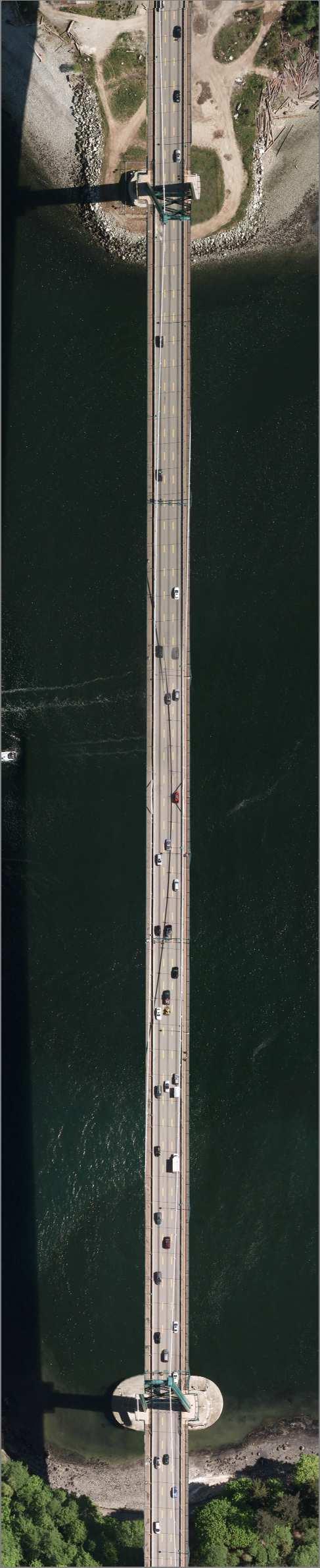
10 Vancouver Fraser Port Authority Centerm Expansion Project Marine Transportation Impact Study 1. Introduction The Centerm Container Terminal (Centerm) on the south shore of Vancouver s inner harbour is one of three primary container terminals in the Vancouver area and handles approximately one-fifth of the container goods shipped through Vancouver. DP World Vancouver (DPWV) operates the terminal on federal lands and waters which is leased from the port authority. Trade of containerized goods shipped through Canada s west coast is increasing; In 2015, container terminals on the west coast of Canada (including Vancouver and Prince Rupert) handled more than 3.8 million Twenty-foot Equivalent Units (TEUs), with nearly 3.1 million TEUs handled by container terminals in the Port of Vancouver. The Port of Vancouver s container terminals (Vanterm, Deltaport, Fraser Surrey Docks, and Centerm) are currently able to handle an estimated 3.9 million TEUs per year. Independent forecasts completed for the Vancouver Fraser Port Authority (port authority) by international experts in transportation and trade indicate that container traffic through the west coast of Canada will increase by approximately 3.5 million TEUs by This growth is driven primarily by the growing demand between Canada and Asian markets for imported products such as clothing, food, electronics and manufacturing inputs, such as car parts, and exports of Canadian products such as pulp, paper, lumber and specialty grains. The proposed Centerm Expansion Project (CEP) is a series of improvements to the Centerm Container Terminal. The proposed infrastructure improvements will increase the number of containers that can be handled at Centerm by approximately two-thirds, from a current maximum annual capacity of 900,000 Twenty-foot Equivalent Units (TEUs) to 1.5 million TEUs. During peak operations, the number of containers that can be handled at the terminal will increase from an annual sustainable capacity of 750,000 TEUs to 1.3 million TEUs. To increase the container capacity of the terminal by 67 per cent, the proposed terminal improvements include an expansion of the terminal footprint by 15 per cent and reconfiguration of the terminal. Refer to Figure 1 for the anticipated expansion of the western end of Centerm. The local marine businesses activities located in the bay between Canada Place and Centerm will be affected by the westward expansion of Centerm as the project will narrow the marine travel path within the corridor. Minor impacts could affect Roger Sugar due to the eastern expansion infill between Centerm and the SRY Property Cep-Rep-Acl-Marine Transportation Impact Study Rev 6 1

11 Vancouver Fraser Port Authority Centerm Expansion Project Marine Transportation Impact Study Figure 1: Centerm Container Terminal Expansion This Marine Transportation Study will discuss the following: Identify marine transportation locations and activities within the vicinity of the project. Identify any marine transportation routes and whether they conflict with any CEP works. Identify constraints to vessels entering the Burrard inlet, and determine the maximum vessel size that could be accommodated by the terminal within the constraints. Consider the changes to the terminal capacity and determine potential changes in the number of vessels calling at the terminal Cep-Rep-Acl-Marine Transportation Impact Study Rev 6 2

12 Vancouver Fraser Port Authority Centerm Expansion Project Marine Transportation Impact Study 2. Marine Transportation Network This section discuss about the existing Marine Transportation Network within the vicinity of the CEP. 2.1 Locations Centerm is located in the Burrard Inlet just north of Dunlevy Ave. There are various marine transportation businesses that are located in the area that has active marine transportation routes in addition to the vessels that are accompanied by Centerm and the cruise ships at Canada Place. The different marine transportation businesses are show in Figure 2 below. Figure 2: Marine Transportation Locations 2.2 Activities There are various types of activities in the Vancouver Harbor within vicinity to CEP. The marine businesses located east of Canada Place (Canada Place Cruise Ship Terminal, SeaBus, Canadian Fishing Company, Main Street Docks, Tymac Launch Services) could be affected by the project, but it is not expected to be a significant impact. All the marine transportation located west of Canada Place (Coal Harbor and Royal Vancouver Yacht Club) is not expected to be effected by the project Cep-Rep-Acl-Marine Transportation Impact Study Rev 6 3
13 Vancouver Fraser Port Authority Centerm Expansion Project Marine Transportation Impact Study Lantic (Rogers Sugar) Lantic s facility located at Stewart Street and Rogers Street is a cane sugar refinery which produces up to tonnes of refined sugar per year from imported raw cane sugar. The site receives large vessels at their dock on a regular basis. The dock is located at the end of Rogers Street and is east of Centerm. During construction there could be some minor impact to vessel movements which may temporarily obstruct vessel paths or require minor course corrections, however these are not considered major interruptions to Lantic s business Southern Railway of BC (SRY) Southern Railway own the Burrard Slip, a property located immediately east of Centerm. The site includes a barge loading ramp with rail tracks however these are current not being used. The proposed CEP project includes infilling the bight between Centerm and the SRY property. There may be some construction disturbance to potential activities on the SRY property, however since SRY is not presently active adjacent to Centerm, this is not considered high impact. If activities on the SRY property change, the impact due to CEP would need to be reviewed with SRY to determine a strategy to limit impacts on operations Canadian Fishing Company (Canfisco) The Canadian Fishing Company (Canfisco) head office is located at the foot of Gore Ave, south of Centerm. Canfisco is a processing and packing business that produces canned seafood. It is expected that small boats and vessels could be traveling to and from the corridor for shipping and receiving purposes on a daily basis Main Street Docks The Main Street Docks is located in the corridor south of Centerm. The Main Street Docks is a Marine port of entry where commercial vessels other than ferry boats or cruise ships report to Canada Border Services Agency (CBSA). It is expected that there will be several boats and small vessels to travel to the Main Street Docks for inspection Tymac Launch Services Tymac Launch Services is also located in the corridor south of Centerm adjacent to the Main Street Docks. The business operates 24 hour, 365 days to service the Vancouver Marine Community. Tymac provides services such as: Pilot boarding and disembarkation Water taxi service Marine towage services Barge services including supply of fresh water Cruise vessel waste removal Transportation of ship s stores Canada Border Services Agency bonded carrier Certified for handling of dangerous goods Barge loading ramp SWL 66 tons Small boats and vessels can be expected to be they types of marine traffic for Tymac Cep-Rep-Acl-Marine Transportation Impact Study Rev 6 4
14 Vancouver Fraser Port Authority Centerm Expansion Project Marine Transportation Impact Study SeaBus The SeaBus is a passenger-only ferry service owned by Translink and operated by Coast Mountain Bus Company. Located east of Canada Place, the SeaBus provides transportation services that cross the Burrard Inlet to connect Vancouver and North Vancouver. The SeaBus departs every 15 minutes during the day and every 30 minutes in the evening. It operates between 6:00 am and 1:00 am from Monday to Saturday, and between 8:00 am and 11:30 pm on Sundays and holidays. More than 50 crossings occur each weekday across the Burrard Inlet Cruise Ship Terminal The Canada Place Cruise Ship Terminal is located at the foot of Howe Street west of Centerm. Tourism is an important business in Vancouver especially during the cruise season between spring and fall. The cruise ships travel through the first narrows into Burrard Inlet, under the Lions Gate Bridge and berth at Canada Place. Canada Place can generally berth up to three cruise ships and has frequent departures and arrivals throughout the season, normally between 7 am and 5 pm. The Canada Place cruise ship terminal is expected to berth the Solstice Class vessels operated by Celebrity Cruise Lines at the eastern berth with increasing frequency. This requires sufficient clearance through the approach channel to navigate to the berth. As a result, whenever a cruise ship is scheduled to arrive/depart Canada Place, all marine vessels operating in the vicinity, in particularly the SeaBus, are delayed passage through the channel of the embayment between Canada Place and Centerm until cruise ships have cleared the channel Coal Harbour Marina The Coal Harbor Marina is located at the foot of Broughton Street, west of Canada Place and used to moor boats and yachts. Small boats and yachts will be expected within the area for leisure purposes. The marine activities in this area will not be affected by CEP Royal Vancouver Yacht Club The Royal Vancouver Yacht Club is located south of Stanley Park, west of Canada Place. The Yacht club is a members only recreational facility for leisure boating. Similar to the Coal Harbor Marina, this area is expected to have frequent small boats and yachts in the area and will not be affected by CEP Cep-Rep-Acl-Marine Transportation Impact Study Rev 6 5

15 Vancouver Fraser Port Authority Centerm Expansion Project Marine Transportation Impact Study 2.3 Marine Transportation Routes There are different marine transportation routes from various marine businesses within the Vancouver Harbor. Most businesses do not have a defined designated route for marine transportation except for the SeaBus. The routes are dynamic with flexibility to change the route to suit the current condition. CEP requires construction at the east and at the west end of the Terminal. The eastern expansion is not anticipated to have a major effect on the marine businesses that are located east of Centerm. However, the western expansion could cause more impact due to the number of marine activities that are located between Canada Place and Centerm Centerm Eastern Expansion The eastern infill expansion is located at the eastside of the Terminal between Centerm and SRY. The SRY property is currently not active therefore construction will not affect SRY. Lantic s marine operations may experience minor impacts to its operations during construction by the eastern infill land expansion. Vessels destined for Lantic are unlikely to require course adjustments on their approach as construction activities will be concentrated in the area immediately adjacent to the Centerm landmass and not within expected approach courses. However, as a result of the construction activities increased vessel traffic will be operating in this area. This will require increased coordination with Port Operations by the contractor, as well as Notices to shipping in regard to the marine construction activities and impacts. Figure 3 shows the proximity of the proposed eastward infill relative to SRY and Rogers Sugar. Figure 3: CEP Eastward Expansion Cep-Rep-Acl-Marine Transportation Impact Study Rev 6 6

16 Vancouver Fraser Port Authority Centerm Expansion Project Marine Transportation Impact Study Centerm Western Expansion The western land expansion is located at the western end of the Terminal between Canada Place and Centerm. The major marine activities within the western corridor are the cruise ship operations for Canada Place and the Seabus passenger ferry. During the cruise season, delays are expected as the corridor is often temporarily blocked due to transiting cruise vessels. Figure 4 shows the western corridor with locations of different businesses than could be affect by the CEP western expansion. Figure 4: CEP Western Expansion With the Centerm expansion, the marine businesses south of the Centerm container terminal will need to make slight adjustments to their courses and would likely have to travel an increased distance due to the westward expansion of CEP. The channel width between Canada Place and Centerm into the embayment will be narrowed from approximately 412m and 317m Furthermore, there may be a slight reduction (less than 5% difference) to the channel into Canfisco. Even with the reduced corridor widths, smaller vessels would still be able to maneuver around the area to reach their destinations as usual. The small boats and vessels at Canfisco will have to travel at a slightly longer travel distance in and out of the Harbour as shown in Figure 5. The other business (Main Street Docks and Tymac) with small vessels traveling to and from the Main Street Docks would also have to travel at a longer travel distance but nothing quite significant enough to cause a major issue. The smaller marine vessels for the local marine operators could be delayed during their travel if the area is saturated with other larger vessels as a result the smaller vessels will have to wait until there is a clear path to pass. See Figure 5 and Figure 6 for more details Cep-Rep-Acl-Marine Transportation Impact Study Rev 6 7

 that could be used if there were no westward expansion.")
17 Vancouver Fraser Port Authority Centerm Expansion Project Marine Transportation Impact Study Figure 5: Marine Transportation Route Adjustment Figure 5 shows a transportation route to access the corridor south of the Centerm is disrupted once the project expansion is complete. If the marine business is trying to access Point A, the marine business must travel at a longer distance (solid red) due to the westward expansion of Centerm as opposed to the shorter route (dashed red) that could be used if there were no westward expansion. Figure 6: Post Construction Corridor Widths Cep-Rep-Acl-Marine Transportation Impact Study Rev 6 8

18 Vancouver Fraser Port Authority Centerm Expansion Project Marine Transportation Impact Study Figure 6 shows the reduced width at the Canfisco entrance and the corridor width between Canada Place and CEP. Canfisco would appear to be the only marine business that might have a minor impact due to the CEP. Before construction, the width of Canfisco s entrance is approximately 60m wide and the width approximate width after construction is approximately 57m. The entrance width to access Canfisco will be reduced, however it is not a significant decrease. The corridor width between Canada Place and CEP could potentially restrict the number of activities that can travel through the corridor. When cruise ships are boarding on the east side of Canada Place, other marine vessels will have to wait till there is a clear path before they can proceed with their destination. The SeaBus is the only marine operation that has a high frequency schedule course that connects Vancouver to North Vancouver. The Centerm expansion appears to introduce a potential conflict with the current SeaBus route (northwest corner of the proposed project). This conflict will require the SeaBus to make a westward course correction by approximately 60m away from the extents of the expansion. The conflict with the current SeaBus route is show in Figure 7. Figure 7: SeaBus route conflict Cep-Rep-Acl-Marine Transportation Impact Study Rev 6 9

19 Vancouver Fraser Port Authority Centerm Expansion Project Marine Transportation Impact Study 3. Burrard Inlet Constraints Burrard Inlet is a natural basin boarded to the north by a mountainous shoreline, and to the south by the peninsula which forms the central downtown core of the city of Vancouver. Access to the open ocean is to the west via an entry channel know as First Narrows, and to the east at Second Narrows the channel extends further and provides navigational access to Indian Arm and Port Moody. Docks, marine facilities and terminals of all types are located within Burrard Inlet. The maximum water depth in some areas exceeds 60m, however the depth in First Narrows limits the navigational draught of transiting vessels to approximately 15m. Due to the geographic constriction of both First and Second Narrows, all of Burrard Inlet experiences strong tidal streams, which reach velocities of up to 6 knots within the confines of the two narrows. In other parts of the inlet, tidal stream velocities of up to 3 knots, which are an important consideration for any manoeuvres, are not uncommon. This includes the approaches to Centerm and neighbouring Canada Place docks. The relative positions of the western extent of Centerm and Canada Place to the west, form a limited width channel through which vessel, particularly SeaBus, Canfisco Fishing vessels and cruise ships pass. This limited width can introduce congestion at the channel. This is a particular problem during cruise season when cruise ships berthed at Canada Place arrive and depart. Other vessels, particularly the Seabus, are impacted (the Seabus occasionally skips departures at these times). Canada Place is anticipating the arrival of Solstice class cruise ships at the eastern berth from 2016 onwards; which are larger than the vessels currently calling at the cruise terminal, increasing the demand on the limited channel width available. The Burrard Inlet constraint is governed by the clearance requirements for a vessel to navigate through the Lions Gate Bridge. Vessels from the Burrard Inlet that is traveling into the Vancouver Harbor must cross the throat of the Burrard Inlet and under the Lions Gate Bridge (see Figure 8). Vessels must meet the requirements based on the parameters that are derived based on current draft, beam and air draft before they can navigate under the Lions Gate Bridge. Figure 8: Burrard Inlet Constraints Cep-Rep-Acl-Marine Transportation Impact Study Rev 6 10
20 Vancouver Fraser Port Authority Centerm Expansion Project Marine Transportation Impact Study 4. Marine Vessels Once CEP is complete, Centerm is expected to receive larger/more vessels to keep the terminal operating efficiently. The type of vessels call at Centerm must also meet the Burrard Inlet constraints. 4.1 Maximum Vessel Size Containership capacity is normally expressed in Twenty-foot Equivalent Units (TEU), which is defined as the number of 20' x 8' x 8'6" containers it can carry; or, similarly, in Forty-foot Equivalent Units. Containerships vary considerably in size and capacity, particularly as the configuration of the hull can significantly impact overall TEU capacity. However, as Figure 9 shows there is a relationship between container vessel TEU capacity and beam, from data in the HIS Fairplay database of container ships Vessel Beam (m) ,000 4,000 6,000 8,000 10,000 12,000 14,000 16,000 18,000 20,000 Vessel TEU Figure 9: Vessel TEU vs Beam Figure 9 shows that a 50m beam limitation equates to a vessel size limitation in the range of 13,000 to 14,000 TEU. This consistent with a Neo-Panamax size vessel which has a nominal LOA of 366m, beam of 49m and draft of 15.2m. Neo-Panamax size vessels are considered to have capacities the range of 10,000 to 14,500 TEU. There are container vessels of up to 18,000 TEU (Ultra Large Container Vessels such as the Triple-E Class) that have a beam dimension only slightly larger than the Neo-Panamax) which may be allowable with some extra coordination, however, as we will see in the next section, air draft will likely limit ships to sizes smaller than this Cep-Rep-Acl-Marine Transportation Impact Study Rev 6 11
21 Vancouver Fraser Port Authority Centerm Expansion Project Marine Transportation Impact Study For reference, the largest container ships currently on order (Triple-E class ships) have a capacity of approximately 21,000 TEU, and the following dimensions: 400m length 59m beam (width) 16m draft when fully laden None of these dimensions are expected to pose significant limitations at the Centerm terminal itself, provided that the wharf can support cranes of sufficient outreach. The most severe constraining element for vessels calling at Centerm is expected to be the air draft of the Lion s Gate Bridge, which ships must pass under to reach the terminal. Currently, the maximum vessel that is permitted to navigate into the Vancouver Harbor without considerable coordination with the Harbour Master and Port Operations is a 50m beam vessel. Based on the worst case scenario, the navigation envelope under the Lions Gate Bridge is 177m (width) by 56m (height) relative to the High Water Datum (See Figure 10 and Appendix A for more details) Cep-Rep-Acl-Marine Transportation Impact Study Rev 6 12
 2016-10-28-Cep-Rep-Acl-Marine Transportation Impact Study Rev 6")
22 Vancouver Fraser Port Authority Centerm Expansion Project Marine Transportation Impact Study Figure 10: Lions Gate Bridge Clearances (drawing provided by Vancouver Fraser Port Authority s Harbour Master) Cep-Rep-Acl-Marine Transportation Impact Study Rev 6 13

23 Vancouver Fraser Port Authority Centerm Expansion Project Marine Transportation Impact Study AECOM analyzed data on ship dimensions from the IHS Fairplay vessel database to determine the maximum size vessels that can pass beneath the bridge under various loading and tidal conditions. AECOM assumed that each vessel is operating at 85% of its maximum laden draft. A ship with a maximum draft of 15m for example would typically call Vancouver at -12.8m. Figure 11 below (Source: shows the tidal range in Vancouver for the week beginning Jan 8, Each day will have two high and two low tides. The highest tides are very close to the +5m listed in the bridge cross section. The highest of the two low tides per day is in the range of 2.0 to 3.5m above datum. Datum in this case refers to the lowest expected tide on an annual basis. Figure 11: Vancouver Tide Chart Cep-Rep-Acl-Marine Transportation Impact Study Rev 6 14
24 Vancouver Fraser Port Authority Centerm Expansion Project Marine Transportation Impact Study The air draft for each vessel was determined by subtracting the operating draft from the keel-to-mast height. Figure 12 shows the analysis of air draft vs vessel capacity. It should be noted that as vessel capacity have increased, the vessel sizes have increasing converged on standardized parameters, reducing the variability of active vessel sizes Lions Datum +2m Lions High Tide (Datum + 5m) ,000 7,000 9,000 11,000 13,000 15,000 17,000 19,000 21,000 Vessel capacity (TEU) Figure 12: Vessel Air Draft vs Bridge Clearance At high tide, vessels of up to 13,000 TEU capacities are expected to be able to pass beneath the bridge. If shipping lines are willing to delay the schedule of their vessels to coincide with low tides at the Lion s Gate, vessels of up to 15,000 TEU could conceivably fit under the bridge. It is worth noting that vessel size is a good, but not perfect, predictor of vessel air draft. Individual ship designs may vary and shipping lines eager to call Vancouver with large ships could potentially use a low profile design to maximize the ship size under the bridge. It seems highly unlikely that vessels much above 16,000 TEU will be able to pass under the Lion s Gate Bridge in order to call at Centerm under any current circumstances, however. For the purposes of this document AECOM has assumed that, due to restrictions of the Lion s Gate Bridge, the largest vessels likely to visit Centerm in the future will be approximately 14,000 TEU in size. As a result of the assessment above, the design vessel anticipated to serve Centerm in the foreseeable future is the Neo-Panamax size (366m LOA, 49m beam, 15.2m draft Cep-Rep-Acl-Marine Transportation Impact Study Rev 6 15
25 Vancouver Fraser Port Authority Centerm Expansion Project Marine Transportation Impact Study 4.2 Future Vessel Calls There is a very strong trend toward larger ships in the container industry. Figure 13 shows the largest ship in the world container fleet from 1970 through the current order book as of late 2015 (which projects vessels that may not begin operations until 2020). Largest Existing Vessel Capacity (TEU) 25,000 20,000 15,000 10,000 5,000 Horizon Navigator (Series) MSC Kyoto SSG Edward A Carter Jr. MSC Sariska (Series) CMA CGM Marco Polo (Explorer Series) Soverign Maersk (S Class) Shanghai Waigaoqiao Maersk McKinney Moller (EEE Class) Emma Maersk (E Class) Figure 13: Size of World s Largest Container Ship over Time Large ships offer considerable economies of scale and it seems logical that shipping lines calling at Centerm will want to use the largest ships that they can regularly fill with cargo. Given that ships of over 18,000 TEU are already in service, it seems a near certainty that over the life of the terminal, ships of maximum practical size (14,000 TEU) will become common place at Centerm. Centerm is expected to have a berth length of 724m after the planned expansion takes place. Vessels of 14,000 TEU have a length of approximately 366m and beam of 49m. A vessel s beam is a good guideline for the desired gap between two vessels at berth. There will also be a constraint at the east end of the Centerm berth, so that in order for two ships to berth and be worked effectively at Centerm, their total length probably can t exceed a length of approximately 650m. If a 14,000 TEU ship is on berth, therefore, a second ship must be at most approximately 270m Cep-Rep-Acl-Marine Transportation Impact Study Rev 6 16
26 Vancouver Fraser Port Authority Centerm Expansion Project Marine Transportation Impact Study 4.3 Number of Vessels The number of vessels that navigate into the Vancouver Harbour is not the governing criteria. Currently, the Vancouver Harbour is not saturated with a high amount of vessels incoming from the Burrard Inlet. The Vancouver Harbour has the capacity to meet an increase in vessel traffic; however the Harbour will be saturated if the rate of one vessel per half hour is expected to navigate from the Burrard Inlet. Centerm is forecasting initial capacity growth at the terminal through an ongoing increase in size of vessels to the fleet calling at the terminal (maximum capacities increasing from 8000 to TEU up to 14,000 TEU).This will be coupled with a gradual increase in the number of vessel calls (from the current average of 5 per week, increasing to an average of 6 per week at full terminal capacity) at the terminal to leverage the enlarged maximum capacity of the terminal. This increase is not expected significantly change the vessel traffic volumes through the Lions Gate. As noted above, the physical dimension of vessels navigating into the Vancouver Harbour is the governing factor, specifically navigating through the Lions Gate Bridge. 4.4 Fendering The existing active berth at the Centerm (berths 5 & 6) was designed to receive vessels with the capacity up to 8,100 TEU. A Berthing System Assessment was commissioned by DPWV in July 2014 to determine if the existing fenders at berth 5 and 6 can accommodate for larger vessels. The assessment concluded that the existing fendering system at Centerm is adequate to receive larger vessels up to 14,000 TEU, however the larger vessels must approach at a slower berthing velocity compared to the original design for 8100 TEU. Table 1 shows the recommended maximum allowable berthing velocity at Centerm (Source: DP World Vancouver Berthing System Assessment, Ausenco, July 2014) Vessel Size (TEU) Original Design ref) 8,100 TEU Design DWT Design Vessel LOA (M) Design Vessel Draught LOA (m) Design Vessel Beam (m) Design Vessel Displacement Berthing Speed (m/sec) 105, , ,000 TEU 125, , ,000 TEU 165, , Table 1: Maximum Allowable Berthing Velocities (with design vessel parameters) As the terminal capacity increases, the berthing velocity restriction may present a limitation to meeting maximum capacity operational needs. Therefore it would be prudent for DPWV to consider long-term berthing operations and undertake additional investigations into the feasibility of upgrading the existing fender system to accommodate 14,000 TEU vessels with no reduction in berthing velocity. These investigations are beyond the scope of the CEP, and would only be needed as terminal capacity approaches its maximum. With larger vessels likely to call at the terminal more frequently, there may be a need in the future to consider upgrading existing bollards between berths 5 & 6. Future investigations should be conducted to assess the feasibility of upgrading four bollards (between berth 5/6) to a 200 ton rating. Similar to potentially upgrading the Cep-Rep-Acl-Marine Transportation Impact Study Rev 6 17

 to 724m.")
27 Vancouver Fraser Port Authority Centerm Expansion Project Marine Transportation Impact Study berth fendering system, this investigation is outside the current scope of CEP, and would only be needed as capacity approaches its maximum and 9,000+ TEU vessels are the prevailing size of calling vessel. 4.5 Mooring Plan Presently, berths 5 & 6 at Centerm form a 646m berth with a mooring dolphin situated 76m west of the berth to provide an effective mooring length of 722m for a 646m berth. The CEP would replace the mooring dolphin with a 78m berth extension, increasing the berth length (and mooring length) to 724m. The increase in berth length does not materially change the effective mooring length available on Centerm s berths 5 & 6. The increase does of course extend the quay crane operating length along the berth significantly. Figure 14 and 16 show the drawings of the existing and proposed berth layout for vessel spacing. Figure 14: Existing Mooring Arrangement Figure 15: Proposed Future Mooring Arrangement 4.6 Cruise Ship Operations The western expansion of the terminal will reduce the width of the channel available between the Centerm and Canada Place. While the marine traffic volumes operating in through this channel expected to remain at similar levels to the existing situation, this reduction in width introduces increased risk of congestion and increases the Cep-Rep-Acl-Marine Transportation Impact Study Rev 6 18
28 Vancouver Fraser Port Authority Centerm Expansion Project Marine Transportation Impact Study possibility of vessels waiting for appropriate space to transit the channel. The manoeuvring of cruise ships into the eastern berth of Canada Place has been identified as the most significant impact to this congestion. Cruise ships navigating into the Vancouver Harbour and being able to berth at Canada Place an important factor to consider. During the summer months, cruise ships will be approaching and departing to/from Canada Place at least 3 times a day typically arriving at 7am and departing at 5pm. Within the cruise season demand, cruise ships will have to navigate and manoeuvre within the Vancouver Harbour at any tidal conditions and wind speeds. A simulation exercise have been developed (using PANAMAX and Ultra Large cruise vessels up to 333 metres in length) for pilots to identify any possible issues when they manoeuvre the cruise ships to berth at Canada Place when CEP have been constructed Current Conditions The current practices for cruise ships berthing at the Canada Place eastern berth, is to navigate through the channel between Canada Place and Centerm rotating the vessel inside the bay and berthing port side. Cruise ships up to 333m have the capability to manoeuvre within the corridor with approximately 90m of clearance from the east. Port side berthing are typically done by the Princess Cruises because they use the east berth tie up on their port side so that they can connect to shore power. The Princess Ships only have a shore power connection on their port side, and cannot connect to shore power when berthed starboard side Post-Centerm Expansion When the Centerm Expansion Project is complete, the channel between Canada Place and the Centerm Terminal will be reduced, as a result larger cruise ships may not be able to safely manoeuvre inside the bay to berth port side at Canada Place s eastern berth. During simulation trials, it was noted that a cruise ship of 333m LOA navigating and manoeuvring inside the bay will have less than 15m of clearance which is not considered as safe practice. It was noted that port side arrivals present a significantly higher degree of risk than all other manoeuvres, and it is recommended that initially these manoeuvres not be attempted when the combined tidal stream velocity exceeds 3.0 knots in First Narrows and the sustained wind exceeds 20 knots, without tug assistance. But it remains at the discretion of the Captain and pilot based on their familiarity of the extension works and the manoeuvrability of their vessel. As a result of the more constrained operating environment after the Centerm project is built, the pilots will have to perform a yaw movement with their cruise vessels north of Canada Place, with the vessel making a stern approach towards the Canada Place berth. Although the cruise ships could experience more wind and tidal stream shear as well as the potential of impeding another vessel s approach to Canada Place as the pilot manoeuver the cruise ship, this stern approach maneuver is believed to be feasible. Theoretically, it will be more advantageous for pilots to rotate the bow of the ship to starboard when the ship is positioned upstream in the flood tidal region where ships rotational direction will work with the tidal stream. This approach may seem easier, however pilots must practice this approach in the simulation before conducting actual vessel manoeuvring. There is an existing shallow between Canada Place and the SeaBus Terminal that will, as a result of the expansion of Centerm, significantly limits vessels from maneuvering in the embayment adjacent to the east berth of Canada Place. The minimum depth of the shallow is 6.2m and larger vessels will not be able to navigate in the area if the height of the tide is less than 2.5m. However, the shallow issue could be mitigated by dredging or a navigation dolphin is constructed at the shallow area. There does not appear to be any major obstacles to the dredging of this area to provide enhanced maneuvering room for cruise ship mooring. Refer to Appendix C for more details of The Manoeuvring Feasibility Study Report, and subsequent Dredging Requirement Analysis Port Side Berthing and Unberthing Simulation Report Cep-Rep-Acl-Marine Transportation Impact Study Rev 6 19
29 Vancouver Fraser Port Authority Centerm Expansion Project Marine Transportation Impact Study 5. Recommendations As larger ships become the norm over the long term, Centerm, even with the planned expansion, will trend toward becoming an one-berth terminal. With a backland and rail capacity of 1.3M TEU/year, the terminal will still be well balanced as ships get larger. For example, assume all ships at Centerm eventually become Neo-Panamax size, (approx. 13,000 TEU), and they load and discharge 50% of their capacity per call. 100% capacity would be approximately 26,000 TEU (100% off and 100% back on) so 50% capacity on a 13,000 TEU vessel is 13,000 TEU of containers moved across the wharf. This equates to 100 vessel calls per year or two per week at terminal capacity. There is not much benefit to further berth expansion at Centerm unless a great deal more backland and rail capacity can also be developed simultaneously. The Centerm expansion project will enable the terminal to handle more of the same sized vessels and enable larger vessels to be accommodated at the same time.. As vessels capacities increase, the number of vessels calls is forecast to rise by an average of one additional vessel per week to reach the projected terminal capacity, therefore, capacity through the Lions Gate Bridge will not be a problem. The harbor still has enough capacity for an increase number of vessels for the future A simulation model of the Centerm Expansion Project was created to allow pilots to practice trial exercises to navigate cruise ships into the Vancouver Harbour and manoeuvre the vessel onto the eastern berth at Canada Place. It was determined that the pilot s preferred approach to manoeuvre within the corridor was considered unsafe due to the clearance distance from the Centerm Expansion Project. As a result of the simulations, the following findings were identified: Due to the reduced width of the camber mouth, it is assessed that starboard side approaches present a much lower degree of risk than port side approaches. Generally starboard side approaches can be conducted without an elevated degree of difficulty. The degree of difficulty associated with port side approaches (typically always done by Princess Cruise vessels to allow shore power connections) will be elevated with the expansion of Centerm. When backing in, the ship is more prone to both wind and tidal stream shear effects due to the lower approach speed that is typically used, and the fact that the ship has to rotate nearly 180 when it is to the NW of the camber entrance, and fully exposed to the tidal stream. With the present amount of space between Centerm and Canada Place, ships can turn inside the camber in the lee of the most severe tidal stream effects (normal practice for Princess Ships) to make a port side landing. It is assessed that this will not be possible for larger ships with the expansion of Centerm as the camber mouth will simply be too narrow to make this a safe operation. On the flood tidal stream, the ship can be more easily controlled if it is turned in a starboard direction to the immediate north of Canada Place. While this manoeuvre is safer and easier than turning to port, it does require the ship to be in a position where it could impede the approach of another cruise vessel that is following close astern with the intention of berthing at Canada Place West or North. The shallow bank (minimum depth 6.2 metres) that lies between the Seabus Terminal and Canada Place greatly complicates all arrivals and departures for larger ships anytime the height of tide is less than 2.5 metres as for all manoeuvres the vessels need to routinely pass within 50 metres of this submerged danger. Subsequent simulations were carried out in July 2016 to develop greater familiarity with stern-board portside berthing approaches. An additional aspect of these simulations was to identify the extent of the shallow that would need to be dredged to maintain an appropriate manoeuvring corridor for approaching cruise ships Cep-Rep-Acl-Marine Transportation Impact Study Rev 6 20
30 Vancouver Fraser Port Authority Centerm Expansion Project Marine Transportation Impact Study As a result of the two sets of simulations, the following recommendations were developed and refined, and are proposed to mitigate potential risks: When vessels berth port side to Canada Place, they should turn outside of the camber and then make a stern-board approach. It is recommended that the outer edge of the 6.2-metre shallow and bank be dredged to a minimum depth of 10 metres, which would create a conical shaped berthing pocket with a uniform boundary of depths greater than 10 metres. This would greatly facilitate rotating the ship both when manoeuvring into and away from the dock. A set of range markers should be installed at the Centerm facility to provide a visual reference that indicates the edge of the controlled depth area. Prior to receiving ships at Canada Place East, post Centerm expansion, it is recommended that manoeuvring familiarisation simulations be run at the BCCP/PPA simulator to allow both pilots and designated cruise ship masters to become familiar with the new space constraints, and specifically to practise making a stern-board approach for port side arrival at the dock. Until real life experience is gathered, and the simulation findings validated against real life manoeuvres, it is recommended that the first twelve port side approaches with vessels greater than PANAMAX size, not be conducted in situations where both: a) the wind is over 20 knots, and also b) the tidal stream at First Narrows is greater than 3 knots. After 12 port side arrivals have been conducted, this restriction can be reassessed Cep-Rep-Acl-Marine Transportation Impact Study Rev 6 21
31 Appendix A Lions Gate Bridge Specified Clearances for Vessels Beam
32
33 Appendix B Manoeuvring Feasibility Study Report
34 Manoeuvring Feasibility Study Berthing and Unberthing Canada Place Centerm Expansion Maritime Simulation and Resource Centre a division of Corporation of Lower St. Lawrence Pilots Inc. Québec (Québec) Canada April 26, 2016
 Canada www.sim-pilot.")
35 Manoeuvring Feasibility Study Berthing and Unberthing Canada Place Centerm Expansion Maritime Simulation and Resource Centre a division of Corporation of Lower St. Lawrence Pilots Inc. Québec (Québec) Canada April 26, 2016
36 April 2016 Maritime Simulation and Resource Centre (MSRC) All translation, reproduction and adaptation rights reserved. Any reproduction of any part whatsoever of this document by any means whatsoever is strictly prohibited, barring the written authorization of the MSRC or AECOM.

37 Manoeuvring Feasibility Study Berthing and Unberthing Canada Place Centerm Expansion REVISION 1 May 19, 2016 This report has been updated to reflect recommendations made by one or more of the parties working on the Canada Place Centerm Expansion project. Responsible Authority Approval The Director of Maritime Simulation and Resource Centre (MSRC) is responsible for this document, including any change, correction or update. Paul Racicot, Director, Maritime Simulation and Resource Centre (MSRC) Date Issued: April 26, 2016 Date Revised: May 19, 2016 Maritime Simulation and Resource Centre April 26, 2016
38 DOCUMENT INFORMATION Title Manoeuvring Feasibility Study Berthing and Unberthing Canada Place Centerm Expansion Originator Maritime Simulation and Resource Centre 271 de l'estuaire Street, Suite 201, Québec, Québec G1K 8S8 Telephone Fax. URL (418) (418) REVISION CHART Revision No Date Affected Pages Authors Brief Description of Changes Executive Summary, last sentence Section 4.2, undersection 4 BCCP s representative and Princess Cruises Representative BCCP s representative It was noted that port side arrivals present a significantly higher degree of risk than all other manoeuvres, and it is recommended that initially these manoeuvres not be attempted when the combined tidal stream velocity exceeds 3.0 knots in First narrows and the sustained wind exceeds 20 knots without tug assistance. But it remains at the discretion of the Captain and the pilot based on their familiarity of the extension works and the manoeuvrability of their vessel. ( ) with winds over 20 knots, or and if the tidal stream at First Narrows is greater than 3 knots. Maritime Simulation and Resource Centre April 26, 2016
39 Executive Summary The planned expansion of Centerm container terminal facilities consists of extending the existing dock structure approximately 75 metres in a direct of 294⁰ true. The WNW corner of Centerm forms the eastern boundary of the entrance camber into the cruise terminal for berthing at Canada Place east dock, and this extension will reduce the available manoeuvring space for larger cruise vessels. As part of the preliminary analysis of this project, a manoeuvring study was commissioned; its purpose, to investigate and assess the impact that the proposed extension of Centerm might have on the manoeuvring safety for cruise vessels of 294 metres and 333 metres length overall (LOA) arriving and departing from Canada Place East. Burrard Inlet is a natural basin boarded to the north by a mountainous shoreline, and to the south by the peninsula which forms the central downtown core of the city of Vancouver. Access to the open ocean is to the west via an entry channel know as First Narrows, and to the east at Second Narrows the channel extends further and provides navigational access to Indian Arm and Port Moody. Docks, marine facilities and terminals of all types are located within Burrard Inlet. The maximum water depth in some areas exceeds 60 metres, however the controlling depth in First Narrows, at zero height of tide is 15 metres, and limits the navigational draught of transiting vessels accordingly. Due to the geographic constriction of both First and Second Narrows, all of Burrard Inlet experiences strong tidal streams, which reach velocities of up to 6 knots within the confines of the two narrows. In other parts of the inlet, tidal stream velocities of up to 3 knots are not uncommon, and this includes the approaches to Centerm and neighbouring Canada Place docks which forms an important consideration for any manoeuvres to and from these terminals. Wind is always a consideration when manoeuvring cruise ships as they have a very large surface area that is affected by wind induced rotation and drift. In Burrard Inlet it is extremely rare for winds to exceed 25 knots, and the wind blows most frequently from either an easterly or westerly direction. During the busy summer cruise ship season, there are normally three vessels visiting Canada Place on the same day, typically arriving at approximately 07:00 and departing at approximately 17:00. Given the demands of the cruise schedules, vessels need to be able to arrive or depart at any state of the tide, tidal stream and with sustained winds up to 20 knots. Prior to conducting the analysis, representatives from the Port of Vancouver and The British Columbia Coast Pilots Ltd. (BCCP) met to discuss the specific tidal stream conditions that should be tested to represent a worse-case analysis. Detailed 3-D current models were then created by Tetra Tech in a format used by the Kongsberg simulator to replicate selected days and conditions from the year Most of the runs were conducted at either the modelled conditions for maximum ebb (31 July 2012 at 06:00) or maximum flood tidal stream (31 July 2012 at 14:00). Maritime Simulation and Resource Centre April 26, 2016
40 The objective of the simulated manoeuvres was to determine safe operating procedures for manoeuvring large vessels to and from the facility, and if any restrictions would need to be imposed based on the following considerations: 1) Confirm that a range of manoeuvring options would still be feasible for both typical PANAMAX-size cruise vessels that are 294 metres LOA (or less) and increasingly common Ultra-Large cruise vessels up to 333 metres LOA; 2) Constraints or restrictions that may need to be imposed due to the effect of tidal stream/back eddies on the safe manoeuvring process; and 3) Any additional constrains that may be created by other environmental factors such as wind speed and direction. A total of seventeen simulated exercises were carried out, nine with the 294-metre ship and eight with the 333-metre long vessel. To conclude, the results of the simulation exercises showed that arrivals and departures for both PANAMAX and Ultra-Large cruise vessels could be conducted under the full range of tidal stream conditions and with winds up to 20 knots. It was noted that port side arrivals present a significantly higher degree of risk than all other manoeuvres, and it is recommended that initially these manoeuvres not be attempted when the combined tidal stream velocity exceeds 3.0 knots in First narrows and the sustained wind exceeds 20 knots without tug assistance. But it remains at the discretion of the Captain and the pilot based on their familiarity of the extension works and the manoeuvrability of their vessel. Maritime Simulation and Resource Centre April 26, 2016
41 i Centerm Extension Canada Place East Berthing TABLE OF CONTENTS 1 Overview 1 Summary of Technical and Human Expertise... 2 Simulation System... 2 Area Model... 3 Ship Models... 4 Test Team... 4 Centerm Terminal Overview Met-ocean Conditions for Centerm 6 Tide and Tidal Stream (Current)... 6 Wind Summary of Real Time Simulation Analysis 9 Existing Operational Rules and Protocol... 9 Testing Methodology... 9 Manoeuvring Results Criteria for Success Summary of Controlled Runs Comments on Physical Layout: Centerm - Canada Place East Observations on Flood Tidal Stream: Centerm - Canada Place Observations on Ebb Tidal Stream: Centerm - Canada Place Observations on Docking Starboard Side with Ebb Tidal Stream Observations on Docking Starboard Side with Flood Tidal Stream General Observations on Docking Port Side Canada Place East Observations on Docking Port Side Ebb Tidal Stream Observations on Docking Port Side Flood Tidal Stream Observations on Undocking Comments on 6.2-metre Shallow and Sub-10-metre Bank General Observations and Recommendations 30 Observations and Findings Recommendations APPENDIX 1 Real Time Simulations Summary 33 APPENDIX 2 Additional Comments from the Pilots 71 Maritime Simulation and Resource Centre April 26, 2016
42 ii Centerm Extension Canada Place East Berthing TABLE OF ILLUSTRATIONS Illustration 1: Simulation test vessels... 1 Illustration 2: Tidal stream flow and surface back eddies during maximum flood tidal stream 14:00 July 31, Illustration 3: Overview of proposed Centerm extension... 5 Illustration 4: Overview of existing Centerm facility... 5 Illustration 5: Modelled tidal stream conditions for 30/31 July Illustration 6: Modelled tidal stream conditions for 24/25 July Illustration 7: Annual wind speed statistics: Vancouver Harbour Illustration 8: Annual wind direction statistics: Vancouver Harbour Illustration 9: Plan view of Canada Place Centerm camber simulator chart Illustration 10: Aerial plan view of Canada Place Centerm camber Illustration 11: Entry into camber on a SSW heading with flood tidal stream Illustration 12: Entry into camber on a near parallel heading with flood tidal stream.. 14 Illustration 13: Typical flood tidal stream flow at surface between Burnaby Shoal and Centerm Illustration 14: Typical flood tidal stream flow at surface inside Canada Place-Centerm camber Illustration 15: Surface Tidal Stream flow at maximum ebb north of Centerm Illustration 16: Surface tidal stream flow at maximum ebb inside Canada Place camber Illustration 17: Starboard side approach PANAMAX vessel with ebb tidal stream Illustration 18: Starboard side approach PANAMAX vessel with ebb tidal stream Illustration 19: Starboard side approach Ultra-Large vessel with ebb tidal stream Illustration 20: Turning late with maximum flood tidal stream and wind 270 at 20 knots Illustration 21: Ultra-Large vessel entering camber on parallel heading - maximum flood tidal stream and wind 270 at 20 knots Illustration 22: Turning early with maximum flood tidal stream and wind 270 at 20 knots Illustration 23: Entering camber on heading parallel to Centerm west face - maximum flood tidal stream and wind 270 at 20 knots Illustration 24: Current practice 333-metre vessel turning inside Canada Place- Centerm camber Illustration 25: Post expansion 333-metre vessel turning inside camber Illustration 26: Turning to the east with ebb tidal stream for port stern-board approach Illustration 27: PANAMAX Stern-board approach to Canada Place Maximum ebb tidal stream Illustration 28: Ultra-Large Vessel turning into flood tidal stream to affect port side arrival Illustration 29: Positioning upstream in flood tide to facilitate rotation to starboard Illustration 30: Departure from Canada Place Ultra-Large vessel Illustration 31: Shallow bank between Canada Place East and Sea-bus Terminal Maritime Simulation and Resource Centre April 26, 2016
43 1 Centerm Extension Canada Place East Berthing 1 Overview Centerm expansion project team have requested the services of the Maritime Simulation and Resource Centre (MSRC) to assess the navigational impact that an extension of the West Northwest corner of Centerm dock might have of both PANAMAX and Ultra-Large cruise vessels berthing and unberthing from the Canada Place East dock. The study took place on 12 and 13 March, 2016 at the MRSC s facilities, and consisted of a series of seventeen manoeuvres ran on the Full Mission Simulator, using a 294-metre long azimuthing podded propulsion (APP) vessel and a conventional powered 333-meter long Ultra Large cruise ship. The following report describes the steps followed, the findings obtained and the resulting recommendations. Illustration 1 below is a representation of the two types of test vessels. Illustration 1: Simulation test vessels Ultra-Large Cruise Vessel: 333 X 38 X 8.5 metres PANAMAX Cruise Vessel: 294 X 32 X 8 metres Maritime Simulation and Resource Centre April 26, 2016
44 2 Centerm Extension Canada Place East Berthing Summary of Technical and Human Expertise The Full Mission Simulator is fully owned by the Corporation of Lower St. Lawrence Pilots (CLSLP) and operated by the MSRC. MSRC s mission is to: Provide training for apprentice pilots; Develop and provide skill improvement techniques for its regular pilots; Develop and provide skill improvement techniques for pilots of other piloted circumscriptions worldwide; Design appropriate ship handling scenarios for pilots as well as for masters and officers; Create comprehensive geographical area databases for any port development project anywhere in the world; Conduct full mission simulation exercises in order to validate ship manoeuvres for new or existing ports; Answer any request from the industry aimed at improving safety at sea. The global experience of the CLSLP s pilots and the highly skilled staff of the MSRC allow its mission to be rewarded with success in all its undertakings. Simulation System The study has been conducted on the Kongsberg s built Full Mission Simulator, Class A and DNV approved 1. It consists of a fully integrated bridge with modern instruments and an uninterrupted field of vision of 330. The PANAMAX ship identified by PMV and The British Columbia Coast Pilots Ltd. (BCCP) for the Centerm analysis was chosen from Kongsberg s library, and the Ultra-Large ship was built by MSRC s in-house team. They all have a very high degree of accuracy, and they were successfully used for the simulations. All manoeuvres were conducted by an experienced BCCP s pilot. Also in attendance was a senior Princess Cruise ship Captain that had experience with docking at Canada Place East. 1 Class A (NAV): A full mission simulator capable of simulating a total shipboard bridge operation situation, including the capability for advanced manoeuvring in restricted waterways. Maritime Simulation and Resource Centre April 26, 2016

45 3 Centerm Extension Canada Place East Berthing Area Model MSRC s own database development tool was used to modify a high-fidelity 3D geographical area model to include the new dock and the proposed bottom dredging work. Electronic Navigation Charts were used for geo-referencing all pertinent aspects of marine navigation: bathymetric contours (including drying areas), spot soundings, terrain elevation, coast line and man-made structures. Additional bathymetric information in 10- and 25-metre grid spacing was provided from Port of Vancouver sources. CAD drawings of the proposed berth were used to position and design the dock structure as well as to reflect post-dredging bathymetric conditions. Satellite imagery and local photography were used to ensure that the visual scenery yielded an accurate area representation including non-charted fixtures commonly used by experienced pilots. Predictions of representative diurnal and semi-diurnal tidal conditions for two different periods (July 16/17, and July 29/30/ ) were modelled by Tetra Tech of Vancouver. These water flow predictions were dynamic covering an entire 24-hour period, and included the vertical height of tide, as well as current direction and velocity values at horizontal levels for depths of 0.3, 1.3, 2.3, 3.3, 5.1, 7.1, 9.6, 12.1 and 14.6 metres. This provided a highly realistic representation of both the dynamic water levels (height of tide) and current/ tidal stream velocities at a 25-metre grid spacing any point in Burrard Inlet for the days previously mentioned, and factored in the effect of the new Centerm dock structure on water flow. Illustration 2: Tidal stream flow and surface back eddies during maximum flood tidal stream 14:00 July 31, Maritime Simulation and Resource Centre April 26, 2016
46 4 Centerm Extension Canada Place East Berthing Ship Models The vessels used for this study were selected by the BCCP and the Port of Vancouver as most representative of the vessel types that currently visit Canada Place cruise terminal and that are expected to call on it into the future. They either come directly from Kongsberg s model library, or were developed by MSRC s ship modelling team. Details are as per below: Table 1: Vessel s characteristics Vessel Type Vessel Name Length LOA (m) Beam (m) PANAMAX Cruise Ultra-Large Cruise Draught Fore/Aft (m) Constellation / 8.0 Dubhe / 8.5 Test Team Table 2: Test team during the full mission simulation Name Role Organisation Cdr Étienne Landry Simulator Operator Maritime Simulation and Resource Centre Captain Christian Ouellet Simulator Operator Maritime Simulation and Resource Centre Captain Garland Hardy Test Director LANTEC Marine Inc. Captain Allan Ranger BCCP Pilot The British Columbia Coast Pilots Ltd. Captain Rod Larden BCCP Pilot The British Columbia Coast Pilots Ltd. Captain Tim Stringer Ship Captain/ Observer Princess Cruise Line Maritime Simulation and Resource Centre April 26, 2016


47 5 Centerm Extension Canada Place East Berthing Centerm Terminal Overview The proposed extension to Centerm will be a solid concrete structure consistent with typical container terminal design. The main berthing and unloading dock along its berthing face will be extended by 75 metres from its existing extremity, however the container storage area to the south of the corner of the berthing face will be extended considerably greater distance towards the shore. To support all of the shore structures, a sloped rock bank will extend approximately 45 metres along the western edge of the new dock. The combination of the dock extension and sloped bank will result in the narrowest portion of the camber mouth being just 380 metres in breadth at an oblique angle to the berthing face at Canada Place East. See illustrations below: Ship s stern is positioned at the extremity of the existing dock structure. Submerged edge of rock slope. Illustration 3: Overview of proposed Centerm extension Existing mooring dolphin. Illustration 4: Overview of existing Centerm facility Maritime Simulation and Resource Centre April 26, 2016
48 6 Centerm Extension Canada Place East Berthing 2 Met-ocean Conditions for Centerm Due to the very sheltered nature of Burrard Inlet, observed wave heights in the vicinity of the terminal rarely exceed 30 centimetres and are fetch-limited. For all practical purposes it can be stated that their effect on the ship is negligible during docking and undocking operations. Wind and Tidal conditions are described below. Tide and Tidal Stream (Current) Vancouver harbour experiences a mean vertical tidal range of 4.75 metres, which is accompanied by strong tidal streams routinely achieving velocities of up to 5 knots in Second Narrows. Due to the nature of the diurnal inequality tides that are experienced in Vancouver, the direction and velocity of the tidal stream varies considerably from day to day and is always an important ship manoeuvring consideration. Tidal stream predictions for both diurnal and semi-diurnal tidal/lunar phases were developed at a 25- metre grids spacing with data layers for 0.3, 1.3, 2.3, 3.3, 5.1, 7.1, 9.6, 12.1 and 14.6 metres and greater. Simulation runs were conducted during the periods where it was assessed that the tidal stream conditions would present the highest degree of manoeuvring difficulty. Illustration 5: Modelled tidal stream conditions for 30/31 July 2012 Maritime Simulation and Resource Centre April 26, 2016
49 7 Centerm Extension Canada Place East Berthing Illustration 6: Modelled tidal stream conditions for 24/25 July 2012 Wind Historical wind data for Burrard Inlet has shown that, for wind speeds above 10 knots, the winds tend to be predominately from either westerly or easterly direction. This is also consistent with the experiential observations of the pilots. The topography provides wind sheltering, and the winds rarely exceed 30 knots, even with some isolated funnelling effects. Winds in excess of 25 knots at Canada Place/Centerm are rare. Based on these parameters, 20-knot wind speed was the maximum velocity tested for berthing and unberthing operations. Maritime Simulation and Resource Centre April 26, 2016
50 8 Centerm Extension Canada Place East Berthing Illustration 7: Annual wind speed statistics: Vancouver Harbour 2015 Illustration 8: Annual wind direction statistics: Vancouver Harbour 2015 Maritime Simulation and Resource Centre April 26, 2016
51 9 Centerm Extension Canada Place East Berthing 3 Summary of Real Time Simulation Analysis This simulation study was divided into two unique components to evaluate how the extension of the Centerm dock would impact on each of the following: The level of difficulty in berthing and unberthing a PANAMAX-size cruise vessel at Canada Place east; and The ability to berth and unberth an Ultra-Large cruise vessel at Canada Place east. Existing Operational Rules and Protocol At present, there are no environmental based restrictions placed on PANAMAX-size vessels calling on Canada Place East. Historically, the BCCP have experienced that berthing and unberthing these large, but highly manoeuvrable vessels can be complicated by the tidal eddy effects, particularly during the periods of maximum ebb and flood tidal stream, and if coupled with strong winds. To minimise the adverse effects of these tidal back eddies, when required to berth port side to the dock, some cruise ship captains will first enter into the camber between Canada Place and Centerm where the effect of the tidal stream is less pronounced and then rotate the ship in order to berth on the dock with a final heading of 062. The Port of Vancouver has an initiative to reduce cruise ship shore side emissions by providing shore power to the ships. Some vessels in order to connect to shore power, must berth port side to at Canada Place East. Testing Methodology For reasons explained in full detail in Sections 3.5 and 3.6 below, berthing port side to Canada Place East is by far the most complex of all of the manoeuvring scenarios. As such, the approach taken in this impact analysis was to conduct manoeuvres with the area model of extended Centerm dock in the following sequence: a) Compare and assess with the PANAMAX ship, both a starboard side arrival with a moderate off-setting wind and tidal condition and a departure with a moderate on-setting wind and tidal condition. This allowed the pilots to benchmark the effects of the new spatial constraints against real-world anecdotal experience for a typical manoeuvre. b) Compare and assess with the PANAMAX ship, starboard side arrivals and departures under the most difficult of wind and tidal stream conditions (winds 20 knots from both the east and west, and tidal stream at maximum ebb and maximum flood). c) Conduct port side arrivals with the PANAMAX ship under the most difficult of wind and tidal stream conditions (winds of 20 knots from both the east and west, and tidal stream at maximum ebb and maximum flood). d) Compare and assess with the Ultra-Large ship, both a starboard side arrival with a moderate off-setting wind and tidal condition, and a departure with a moderate on-setting wind and tidal condition. This allowed the pilots to Maritime Simulation and Resource Centre April 26, 2016
52 10 Centerm Extension Canada Place East Berthing benchmark the effects of the new spatial constraints against real-world anecdotal experience for a typical manoeuvre. e) Compare and assess with the Ultra-Large ship, starboard side arrivals and departures under the most difficult of wind and tidal stream conditions (winds of 20 knots from both the east and west, and tidal stream at maximum ebb and maximum flood). f) Conduct port side arrivals with the Ultra-Large ship under the most difficult of wind and tidal stream conditions (winds of 20 knots from both the east and west, and tidal stream at maximum ebb and maximum flood). All runs were conducted with two pilots and the cruise ship master in the Full Mission Bridge that was used to simulate the cruise vessels. The pilots, cruise ship captain, and the test director each took notes of any events or observations that were pertinent to the outcome of the run, and these were compiled by the data collector into the run logs which are attached to this report. Playback recordings and complete data captures of all runs were collected, and are compiled as a separate annex to this report. Additional comments from the BCCP pilots are also included in Appendix 2. Maritime Simulation and Resource Centre April 26, 2016
53 11 Centerm Extension Canada Place East Berthing Manoeuvring Results Criteria for Success Manoeuvres are marked as "pass," "limit" or "fail", according to the following criteria: Pass (P) The pilot remains in full control of the ship throughout the entire manoeuvre; The ship remains in the channel and/or the turning basin; The ship stays clear of obstructions and quay structures; When lateral thrusters are used, a good power reserve is always available; Docking manoeuvres are achieved as planned while maintaining a safe speed without difficulties; For undocking manoeuvres, the ship leaves the quay smoothly without any risk of inflicting damage to the port installations; The combination of anchor/engine/rudder makes the ship crab towards the berth easily. Limit (L) The pilot considers that the ship is just barely under control during the manoeuvre; The ship leaves the channel or turning basin, while keeping adequate under-keel clearance; The ship gets too close of obstructions and quay structures; When lateral thrusters are used, they are close to their maximum capacities; For docking manoeuvres, the speed of approach is higher than normal. The manoeuvre can be completed, but with risk of minor damage to the facilities; For undocking manoeuvres, the ship has some difficulty leaving the quay. The manoeuvre is completed with some risks of causing damage to the port facilities; The combination of anchor/engine/rudder is barely enough to make the ship crab towards the berth. Fail (F) The pilot loses control of the ship; The ship leaves the channel or turning basin with unacceptable under-keel clearance and/or the ship runs aground; The ship collides with obstacles or harbour facilities; When lateral thrusters are used, they are running at their maximum capacities without succeding in offsetting the external factors; During docking manoeuvres, it is not possible to dock the ship, or the ship bumps into the harbour facilities hard enough to cause major damage; While getting under way, the ship cannot leave the quay at all or encounters significant handling difficulties that might cause major damage to both the ship and the harbour facilities; The combination of anchor/engine/rudder is not enough to make the ship crab towards the berth. Maritime Simulation and Resource Centre April 26, 2016
54 12 Centerm Extension Canada Place East Berthing Summary of Controlled Runs The simulation scenarios commenced with two familiarisation runs, followed by 15 controlled runs. A summary of all runs conducted are listed below: Table 3: Simulation run list. Controlled Runs PANAMAX 294 metre LOA Constellation Model Run Description Wind Manoeuvre Tidal stream 24 July, 19:00 Medium Flood Tidal stream 25 July, 14:00 Light Ebb. Tidal stream 31 July, 06:00 medium to strong Ebb. Tidal stream 31 July, 06:00 medium to strong Ebb. Tidal stream 31 July, 14:00 max flood. Tidal stream 31 July, 14:00 max flood. Tidal stream 31 July, 14:00 max flood. Tidal stream 31 July, 06:00 medium to strong Ebb. 270 at 10 knots Berthing starboard side 090 at 10 knots Unberthing starboard side 090 at 20 knots Berthing starboard side 090 at 20 knots Unberthing starboard side 270 at 20 knots Berthing starboard side 270 at 20 knots Unberthing starboard side 270 at 20 knots Berthing port side 090 at 20 knots Berthing port side Tidal stream 31 July, 14: at 20 knots Berthing port side max flood. Controlled Runs Utra-Large 333 metre LOA Dubhe Model Run Description Wind Manoeuvre Tidal stream 24 July, 19:00 Medium Flood Tidal stream 25 July, 14:00 Light Ebb. Tidal stream 31 July, 06:00 medium to strong Ebb. Tidal stream 31 July, 06:00 medium to strong Ebb. Tidal stream 31 July, 14:00 max flood. Tidal stream 31 July, 14:00 max flood. Tidal stream 31 July, 14:00 max flood. Tidal stream 31 July, 06:00 medium to strong Ebb. 270 at 10 knots Berthing starboard side 090 at 10 knots Unberthing starboard side 090 at 20 knots Berthing starboard side 090 at 20 knots Unberthing port side 270 at 20 knots Berthing starboard side 270 at 20 knots Berthing starboard side 270 at 20 knots Berthing port side 090 at 20 knots Berthing port side Maritime Simulation and Resource Centre April 26, 2016


55 13 Centerm Extension Canada Place East Berthing Comments on Physical Layout: Centerm - Canada Place East The positioning and angle of the dock at Canada Place in relation to Centerm and the adjacent shoreline is less than ideal. This is a product of many factors, not the least of which is that Canada Place, since its original construction in 1984/85, has been extended by 185 metres in a direction of 062, and Centerm has also been extended. Furthermore, the berthing face of Canada Place East is not parallel to what will be the new western end of the Centerm facility. If a line is extended through the plane of the berthing face of Canada Place in a direction of 062 it passes only 85 metres from the position of the proposed rock slope at the WNW corner of Centerm. This makes it practically impossible for a ship to approach the berth on a typical heading that is either slightly inclined into the berth, or at the least parallel to the berthing face. See illustrations below: An extension of the plane of the berthing face of Canada Place passes less than 90 metres from the proposed Centerm rock slope making it impractical to approach the dock on a parallel heading. A PANAMAX ship on a parallel heading to the dock has very little clearance, both at the bow and stern. Illustration 9: Plan view of Canada Place Centerm camber simulator chart Illustration 10: Aerial plan view of Canada Place Centerm camber Maritime Simulation and Resource Centre April 26, 2016

56 14 Centerm Extension Canada Place East Berthing With the extension of Centerm, vessels entering to Canada Place East, particularly on a flood tidal stream, will likely pass between the extreme corners of Canada Place and Centerm on a heading of 200 to 220, and then have to make a carefully calculated turn to a final heading of 242. See illustration below: Entering the camber on a SSW heading provides more clearance on Centerm, and the flood tidal stream can facilitate inducing rotation to starboard onto a heading parallel to the dock. Illustration 11: Entry into camber on a SSW heading with flood tidal stream On the flood tidal stream, a more direct, or near parallel approach into the camber has elevated risk, as the ship must past very close to Centerm, and the tidal stream is constantly setting it towards the WNW corner of the terminal. With a near parallel approach, the ship passes very close to both Centerm and the corner of Canada Place. Illustration 12: Entry into camber on a near parallel heading with flood tidal stream Maritime Simulation and Resource Centre April 26, 2016
57 15 Centerm Extension Canada Place East Berthing Observations on Flood Tidal Stream: Centerm - Canada Place The bathymetry and topography of Burrard Inlet, and in fact all of the Pacific Northwest region create tidal conditions that can vary considerably from day to day dependant on a variety of factors, the most important of which are the phase of the moon, and meteorological conditions. Even within the context of these known daily variations, there is a prevailing pattern of tidal stream (horizontal tidal flow) that exists between Burnaby Shoal and the Centerm-Canada Place camber. Anecdotal experience has shown, and sophisticated tidal flow models clearly illustrate that, during the flood tidal stream, the tidal inflow to the north of the 20-metre contour between Burnaby Shoal and Centerm is quite linear and that the velocities of the tidal stream at the surface of the deep channel range from 2.5 to 4.0 knots at maximum flood. To the south of the 20-metre contour, the flood tidal stream gets deflected in the vicinity of the WNW corner of Centerm, resulting in the formation of a clockwise direction back eddy with surface velocities in the range of 1.0 to 2.5 knots. Inside the Canada Place-Centerm camber, the velocity of the generally clockwise flow tends to be less than 1.0 knots at the surface. See illustrations next page: Maritime Simulation and Resource Centre April 26, 2016


58 16 Centerm Extension Canada Place East Berthing Note that tidal stream flow north of the 20-metre contour is quite linear and strong with velocities up to 4.0 knots at the surface. Near the WNW corner of Centerm, a clockwise back-eddy starts to form. Illustration 13: Typical flood tidal stream flow at surface between Burnaby Shoal and Centerm The deflected flood tidal stream sets to the south on the east side of the camber, then veers to the west and north at velocities less than 1.0 knot. Illustration 14: Typical flood tidal stream flow at surface inside Canada Place-Centerm camber Maritime Simulation and Resource Centre April 26, 2016


59 17 Centerm Extension Canada Place East Berthing Observations on Ebb Tidal Stream: Centerm - Canada Place On an ebb tidal stream, the flow along the north face of Centerm and past the northeast tip of Canada Place is unrestricted, and the greatest volume of water tends to follow along the lines of the 20-metre contour. Surface velocities to the north of the 20-metre contour are typically in the 2.0- to 2.5-knot range, and between the docks and the 20-metre contour in the range of 1.0 to 2.0 knots. There is little back eddy effect on the ebb stream. This is illustrated in the images below. General tidal stream surface flow is parallel to the 20-metre contour. Illustration 15: Surface Tidal Stream flow at maximum ebb north of Centerm Tidal stream direction is only slightly deflected to the south as it passes the WNW tip of Centerm. Illustration 16: Surface tidal stream flow at maximum ebb inside Canada Place camber Maritime Simulation and Resource Centre April 26, 2016


60 18 Centerm Extension Canada Place East Berthing Observations on Docking Starboard Side with Ebb Tidal Stream The starboard side approach to Canada Place East coupled with maximum ebb tidal stream and easterly wind at 20 knots proved to be the docking scenario which at the environmental limits, still afforded the pilots the highest degree of manoeuvring control, both for the PANAMAX and Ultra-Large ship. From a position north of Burnaby Shoal, until affecting the turn to starboard to enter the Canada Place camber, the tidal stream is at a small angle on the bow, and it slows the forward motion of the ship over the ground. This facilitates making corrections, both for heading and for the ship s geographical position in relation to the planned approach track. Once the turn is started, the pilot can plan to pass relatively close to the corner of Centerm as the environmental effects are setting the ship to the west, away from the terminal. As the ship approaches the corner of Centerm, the velocity to the tidal stream diminishes yet continues to provide a controllable set towards the berth at Canada Place East. This allows the pilot to rotate the vessel s heading close to parallel to that of Canada Place (242 ) prior to the bow of the ship passing the northeast corner of Canada Place. See illustrations below: As the ship is turned to a southerly heading, the tidal stream sets the vessel away from Centerm at a rate that can be managed by the pilots with moderate thruster and/or azimuth application. In this area the tidal stream slows the ship s forward motion and does not generate much lateral set. Illustration 17: Starboard side approach PANAMAX vessel with ebb tidal stream Maritime Simulation and Resource Centre April 26, 2016


61 19 Centerm Extension Canada Place East Berthing NW of Centerm, the tidal stream sets the ship to the west, this allows the pilot to use thrust to port while rotating the ship s heading to starboard to position the ship near parallel to Canada Place East prior to entering the camber. With the ship near parallel to Canada Place East from this position the pilot can execute a very controlled final approach, being set on the dock lightly by the tidal stream and wind. Illustration 18: Starboard side approach PANAMAX vessel with ebb tidal stream The effects of the ebb stream allowed the pilot to make a quite slow approach with the Ultra-Large ship and then rotate it parallel to the dock once due west of Centerm where the effect of the tidal stream is reduced. Once the ship is in this position, the tidal stream sets the ship very lightly towards the berth and the heading can be easily controlled. Illustration 19: Starboard side approach Ultra-Large vessel with ebb tidal stream Maritime Simulation and Resource Centre April 26, 2016

62 20 Centerm Extension Canada Place East Berthing Observations on Docking Starboard Side with Flood Tidal Stream Maximum flood tidal stream coupled with a 20-knot westerly wind creates a considerably more complicated approach to Canada Place East for a starboard side docking. In the vicinity of Burnaby Shoal until northwest of Centerm, the flood stream accelerates the vessel s ground speed and elongates its turning diameter. If the ship s water speed is too low, or if the turn to starboard is not initiated early enough, the ship will be set severely to port, well to the east of the desired approach track. If the ship is not well positioned prior to being northwest of Centerm, the tidal stream will set it directly towards the corner of the terminal, and near full thruster/azimuth power will be needed to recover. As such, attempting to enter the Canada Place camber on a heading near parallel to the berth should be avoided on a flood stream. This situation is illustrated below. The flood stream accelerates the ship in a south-easterly direction and elongates its turning diameter. Thrusters are used at full power in order to laterally displace the ship to starboard and to fight the influence of the tidal stream which is setting the ship onto Centerm. Illustration 20: Turning late with maximum flood tidal stream and wind 270 at 20 knots Maritime Simulation and Resource Centre April 26, 2016


63 21 Centerm Extension Canada Place East Berthing Surface tidal stream running at more than 3 knots severely sets the ship towards Centerm. The clockwise back eddy pushes the stern to starboard, inducing starboard rotation that needs to be promptly arrested when the bow is in this vicinity. Illustration 21: Ultra-Large vessel entering camber on parallel heading - maximum flood tidal stream and wind 270 at 20 knots In order to mitigate risk and to reduce the potential adverse effects of the flood tidal stream, it is preferred to position the ship further to the west on the approach track and to enter the camber on a heading that is closer to parallel to the new western face of Centerm. This technique requires less use of the thrusters to control rotation, and the clockwise back eddy in the mouth of the camber can be used to advantage to assist with rotating the ship to starboard towards a heading that is parallel to Canada Place. This manoeuvre is not without complications, as forward speed needs to be carefully managed, the ship s bow must also stay in very close proximity to Canada Place while rotating to starboard and avoiding the shallow patch that lies to the immediate north of the Sea-bus terminal. See illustrations on the next page: Maritime Simulation and Resource Centre April 26, 2016


64 22 Centerm Extension Canada Place East Berthing The overall turn angle while in the strong tidal stream is much smaller, as the ship enters the camber on a heading parallel to Centerm s western face. By turning close to Burnaby shoal, and maintaining a higher water speed, the pilot has more space to the east to manage tidal stream induced drift. Illustration 22: Turning early with maximum flood tidal stream and wind 270 at 20 knots From this position, the clockwise back eddy can be used to advantage to rotate the ship s heading approximately 40⁰ to starboard. Care needs to be taken to not advance too far into the camber, and to avoid the 6.2-metre shallow and its bank. Illustration 23: Entering camber on heading parallel to Centerm west face - maximum flood tidal stream and wind 270 at 20 knots Maritime Simulation and Resource Centre April 26, 2016


65 23 Centerm Extension Canada Place East Berthing General Observations on Docking Port Side Canada Place East Port side approaches to Canada Place East are inherently more difficult as when backing in the ship is more prone to both wind and tidal stream shear effects due to the lower approach speed that is typically used, and the fact that the ship has to rotate nearly 180 when it is to the north of the camber entrance, and fully exposed to the tidal stream. With the present amount of space between Centerm and Canada Place, PANAMAX-size ships can turn inside the camber in the lee of the most severe tidal stream effects (normal practice for Princess Ships) to make a port side landing. It is assessed that this will not be possible for larger ships with the expansion of Centerm as the camber mouth will simply be too narrow to make this a safe operation. See illustrations below: With the existing manoeuvring space, a 333 metres LOA ship can be turned inside the camber and still have approximately 80 metres of clearance to the east. Illustration 24: Current practice 333-metre vessel turning inside Canada Place-Centerm camber Maritime Simulation and Resource Centre April 26, 2016


66 24 Centerm Extension Canada Place East Berthing Once Centerm is extended, the same 333 metres LOA ship would have less than 15 metres ahead and astern when turning. This is considered too restrictive to be safe. Illustration 25: Post expansion 333-metre vessel turning inside camber Maritime Simulation and Resource Centre April 26, 2016
67 25 Centerm Extension Canada Place East Berthing Observations on Docking Port Side Ebb Tidal Stream When docking port side to the berth with maximum ebb tidal stream and an easterly wind of 20 knots, the preferred manoeuvring option is to initiate a turn to port when north of Canada Place. This allows the ship to turn into the flow of the ebb tidal stream which reduces the vessel s forward ground speed and facilitates the early stages of the turn. Additionally, as the vessel designated to berth at the east face of the cruise terminal is normally the lead ship in a group of three morning arrivals, this ensures that the vessel is turned away from the other vessels that maybe following very close astern. Care needs to be taken to ensure that the ship advances sufficiently to the east when turning, otherwise considerable thruster power will be needed to displace the ship laterally against the ebb stream and to align it in a suitable position to make a stern-board approach to the berth. See illustrations that follow: With the ebb tidal stream, the ship can be rotated to port approximately 1.5 to 2 ship lengths to the north of Canada Place and then backed into the camber. The ebb tidal stream that runs parallel to the 20-metre contour slows the vessel s forward speed. Care needs to be taken to ensure that the vessel s advances sufficiently to the east, otherwise a significant amount of thruster power is needed to displace the ship laterally against the ebb tidal flow. Illustration 26: Turning to the east with ebb tidal stream for port stern-board approach Maritime Simulation and Resource Centre April 26, 2016

68 26 Centerm Extension Canada Place East Berthing As the stern enters the camber, the stronger ebb tide on the bow pushes the bow to port towards the dock. Considerable thruster power was needed to keep the bow off of the corner. At the same time the pilot needed to ensure the stern did not pass over the shallow bank. Illustration 27: PANAMAX Stern-board approach to Canada Place Maximum ebb tidal stream Observations on Docking Port Side Flood Tidal Stream When docking port side to the berth with maximum flood tidal stream and a westerly wind of 20 knots, the preferred manoeuvring option is to initiate a turn to starboard when north of Canada Place. This allows the ship to turn into the flow of the flood tidal stream which reduces the vessel s forward ground speed and facilitates the early stages of the turn. One potential complication for this manoeuvre is that the vessel designated to berth at the east face of the cruise terminal is normally the lead ship in a group of three morning arrivals, and this manoeuvre necessitates that the vessel is turned towards the other vessels that maybe following very close astern to berth at Canada Place West and North. As such, the lead vessel needs to notify the ships that are following of its intentions. See illustrations 28 and 29, next page: Maritime Simulation and Resource Centre April 26, 2016


69 27 Centerm Extension Canada Place East Berthing Turning to starboard facilitates rotation onto the approach for a port side landing, but can potentially impede another vessel s approach to Canada Place West/ North, as there is only a few hundred metres between the ship and Burnaby Shoal. Illustration 28: Ultra-Large Vessel turning into flood tidal stream to affect port side arrival This approach uses the tidal stream to advantage to rotate the bow of the ship to starboard as the stern enters the camber. This manoeuvre should be practised by the pilots prior to conducting actual vessel arrivals. Illustration 29: Positioning upstream in flood tide to facilitate rotation to starboard Maritime Simulation and Resource Centre April 26, 2016

70 28 Centerm Extension Canada Place East Berthing Observations on Undocking Departures from Canada Place East from either a port side or starboard side position under all tested environmental conditions, did not present an elevated degree of risk to either the PANAMAX or Ultra-Large cruise vessels. One cautionary note is that the pilot must ensure that the ship (stern or bow depending on port or starboard side to) is well clear of the 6.2-metre shallow bank prior to rotating the ship to the west in order to clear Centerm. The complications associated with this shallow patch are discussed further in Section 3.14, also see illustration below: As the ship approaches the end of Canada Place outbound, (bow or stern first) it needs to be rotated in a counterclockwise direction to ensure that it clears Centerm prior to generating too much northerly momentum. At the same time, care must be taken not to swing the opposite end of the ship over the 6.2-metre shallow. In this specific case as the bow of the ship is rotated to port, the starboard passes along the red line at a distance of about 30 metres from the shallow. Illustration 30: Departure from Canada Place Ultra-Large vessel Maritime Simulation and Resource Centre April 26, 2016
 that lies between the Sea-bus Terminal and Canada Place is an important manoeuvring consideration for vessels berthing and un-berthing from Canada Place east.")

71 29 Centerm Extension Canada Place East Berthing Comments on 6.2-metre Shallow and Sub-10-metre Bank Anytime the height of tide is less than 2.5 metres, the shallow bank (minimum depth of 6.2 metres) that lies between the Sea-bus Terminal and Canada Place is an important manoeuvring consideration for vessels berthing and un-berthing from Canada Place east. With the extension of the Centerm dock, the reduction in space at the camber mouth means that arriving vessels need to wait later before they can turn to align parallel to the dock, and departing vessels need to start to rotate to the north earlier. Post-expansion, the shallow bank greatly complicates all arrivals and departures for any ships longer than 250 metres LOA, as for all manoeuvres the vessels need to routinely pass within 50 metres of this submerged danger. See illustrations below: The position of the 6.2-metre bank requires that the ship be rotated near parallel to the dock while still in the tidal stream, prior to entering the camber. If it was removed, there would be considerably more space to adjust the vessel s alignment once inside the camber. Illustration 31: Shallow bank between Canada Place East and Sea-bus Terminal Maritime Simulation and Resource Centre April 26, 2016
72 30 Centerm Extension Canada Place East Berthing 4 General Observations and Recommendations The duration of this study was only two days, and the primary focus was to determine if the proposed extension of Centerm Terminal would affect safe operating procedures for manoeuvring large cruise ships to and from Canada Place East, and if any restrictions would need to be imposed based on the following considerations: 1) That a range of manoeuvring options would still be feasible for both typical PANAMAX-size cruise vessels that are 294 metres LOA (or less) and increasingly common Ultra-Large cruise vessels up to 333 metres LOA; 2) Constraints or restrictions that may need to be imposed due to the effect of tidal stream/back eddies on the safe manoeuvring process; and 3) Any additional constrains that may be created by other environmental factors such as wind speed and direction. The observations noted below, and recommendations provided were formed as part of a collective analysis of the proposed manoeuvring situation by personnel from the entire test team (MSRC, BCCP, Princess Cruise Lines). Observations and Findings The results of the simulation exercises showed that arrivals and departures for both PANAMAX and Ultra Large cruise vessels up to 333 metres in length could be conducted safely with the following stipulations: 1) Due to the reduced width of the camber mouth, it is assessed that starboard side approaches present a much lower degree of risk than port side approaches. Generally starboard side to approaches can be conducted without an elevated degree of difficulty. 2) The degree of difficulty associated with port side approaches (required procedure for any vessels that can receive power only on their port side) will be elevated with the expansion of Centerm. With the present amount of space between Centerm and Canada Place, ships can turn inside the camber in the lee of the most severe tidal stream effects (normal practice for Princess Ships) to make a port side landing. It is assessed that this will not be possible for larger ships with the expansion of Centerm as the camber mouth will simply be too narrow to make this a safe operation; this is discussed in detail in Section ) On the flood tidal stream, the ship can be more easily controlled if it is turned in a starboard direction to the immediate north of Canada Place. While this manoeuvre is safer and easier than turning to port, it does require the ship to be in a position where it could impede the approach of another cruise vessel that is following close astern with the intention of berthing at Canada Place West or North; see observations in Section ) The shallow bank (minimum depth of 6.2 metres) that lies between the Sea-bus Terminal and Canada Place greatly complicates all arrivals and departures for ships with a LOA greater than 250 metres, anytime the height of tide is less than 2.5 metres as for all manoeuvres the vessels need to routinely pass within 50 metres of this submerged danger. See illustration and discussion in Section Maritime Simulation and Resource Centre April 26, 2016
73 31 Centerm Extension Canada Place East Berthing Recommendations 1) The preferred approach for Canada Place East will be a starboard side to arrival. 2) If vessels must berth port side to Canada Place, they should turn outside of the camber and then make a stern-board approach. 3) Prior to receiving ships at Canada Place East, post Centerm expansion, it is recommended that further familiarisation simulations be run to allow pilots to become familiar with the new space constraints, and specifically to practise making a stern-board approach for port side arrival at the dock. 4) Until real life experience is gathered (12 or more port side arrivals) it is recommended that port side approaches not be conducted with winds over 20 knots, and if the tidal stream at First Narrows is greater than 3 knots. After 12 port side arrivals have been conducted, this restriction can be re-assessed. 5) It is recommended that the 6.2-metre shallow and bank be dredged to a minimum depth of 9 metres, greatly increasing manoeuvring space within the camber. 6) If the dredging mentioned in item 5 above is prohibitive, then as a minimum, a dolphin fitted with a radar reflector, and/or AIS beacon should be constructed to provide a clear visual reference to the exact position of this shallow. Maritime Simulation and Resource Centre April 26, 2016
74 33 Centerm Extension Canada Place East Berthing APPENDIX 1 Real Time Simulations Summary Maritime Simulation and Resource Centre April 26, 2016
75 34 Centerm Extension Canada Place East Berthing Port of Vancouver s Centerm Expansion Project British Columbia March 2016 Scenario: Run-01 Area: Port of Vancouver Berth: Canada Place-East Start: 09h49 Elapsed Time : 00:27:50 Date : 12 March 2016 End: 10h17 Currents file: Cen_ext_scecde.edt (17h00 + 2) Ownship: CRUIS08 Current at Second Narrows: 4.0 kn Flood Ebb Slack Tug: Moderate flood Water level at Second Narrows: 3.8 m Quantity: Bollard pull t Waves: Dir.: 260 Height: 0.2 m Length: 3.2 m Period : 1.4 sec Efficiency coefficient: % Wind: Dir. 260 Speed: 10.0 kn Remarks/Comments: Departure position: N / W Ship s course & speed (SOG): 121 x 6.0 kn Visibility: unrestricted Berthing starboard side to. Approached Canada Place from First Narrows, abeam with Brockton Pointe, and turned the ship to starboard toward the berth. On the Excel spread sheet, the lateral speed FWD/AFT is not always recorded. This is caused by the wash effect of the propeller. CPA on buoy 71 metres. Pilot s comments : In control of the ship all the time. General comments: Manoeuvre was assessed as a Pass in accordance with defined navigational safety/control criteria. SHIP MODELS OWNSHIP TUG Model: CRUIS08 Model: LOA: m LOA: m Breath: 32.2 m Breath: m Displacement: t Displacement: t Draft FWD & AFT: 8.0 / 8.0 m Draft FWD & AFT: m Type of propulsion : APP (2) Bollard pull: t Type of rudder: Type of propulsion: Bow thruster(s): kw Skeg: Stern thruster(s): kw Kongsberg file: Snag file: Diagrams and data: Pilot(s): Instructor(s)/Operator(s): Editor: Princess Cruise Line Representative: RUN-01-Instructor Station LOG RUN-01.avi PRJ_Vancouver_Cent Term_Day-1. Captain Rod Larden, Captain Al Ranger Cdr Étienne Landry, Captain Christian Ouellet Captain Garland Hardy Captain Tim Stringer Maritime Simulation and Resource Centre April 26, 2016
76 35 Centerm Extension Canada Place East Berthing Run 01 Maritime Simulation and Resource Centre April 26, 2016
77 36 Centerm Extension Canada Place East Berthing Port of Vancouver s Centerm Expansion Project British Columbia March 2016 Scenario: Run-02 Area: Port of Vancouver Berth: Canada Place-East Start: 10h38 Elapsed Time : 00:16:43 Date : 12 March 2016 End: 10h55 Currents file: Cen_ext_scecde.edt (17h ) Ownship: CRUIS08 Current at Second Narrows: 1.8 kn Flood Ebb Slack Tug: Moderate ebb Water level at Second Narrows: 2.7 m Quantity: Bollard pull t Waves: Dir.: 090 Height: 0.2 m Length: 3.2 m Period : 1.4 sec Efficiency coefficient: % Wind: Dir. 90 Speed: 10.0 kn Remarks/Comments: Departure position: Canada Place-East Ship s course & speed (SOG): 241 x 0.0 kn Visibility: unrestricted Unberthing. On the Excel spread sheet, the lateral speed FWD/AFT is not always recorded. This is caused by the wash effect of the propeller. From this simulation, parameters logging pan have been set to record 5 thrusters. Closest point of approach of: o buoy off Centerm expansion project = 100 m; o beginning of the slope off Centerm expansion project = 140 m. Pilot s comments : In control of the ship all the time. Recommend to remove the 6.2 m shoal located south of Canada Place-East. General comments: Manoeuvre was assessed as a Pass in accordance with defined navigational safety/control criteria. SHIP MODELS OWNSHIP TUG Model: CRUIS08 Model: LOA: m LOA: m Breath: 32.2 m Breath: m Displacement: t Displacement: t Draft FWD & AFT: 8.0 / 8.0 m Draft FWD & AFT: m Type of propulsion : APP (2) Bollard pull: t Type of rudder: Type of propulsion: Bow thruster(s): kw Skeg: Stern thruster(s): kw Kongsberg file: Snag file: Diagrams and data: Pilot(s): Instructor(s)/Operator(s): Editor: Princess Cruise Line Representative: RUN-02-Instructor Station LOG RUN-02.avi PRJ_Vancouver_Cent Term_Day-1. Captain Rod Larden, Captain Al Ranger Cdr Étienne Landry, Captain Christian Ouellet Captain Garland Hardy Captain Tim Stringer Maritime Simulation and Resource Centre April 26, 2016

78 37 Centerm Extension Canada Place East Berthing Run 02 Maritime Simulation and Resource Centre April 26, 2016
79 38 Centerm Extension Canada Place East Berthing Port Of Vancouver s Centerm Expansion Project British Columbia March 2016 Scenario: Run-03 Area: Port of Vancouver Berth: Canada Place-East Start: 11h06 Elapsed Time : 00:25:51 Date : 12 March 2016 End: 11h32 Currents file: Cen_ext_sceab.edt (20h ) Ownship: CRUIS08 Current at Second Narrows: 3.5 kn Flood Ebb Slack Tug: Medium ebb Water level at Second Narrows: 2.8 m Quantity: Bollard pull t Waves: Dir.: 090 Height: 0.2 m Length: 3.2 m Period : 1.4 sec Efficiency coefficient: % Wind: Dir. 090 Speed: 20.0 kn Remarks/Comments: Departure position: N / W Ship s course & speed (SOG): 121 x 6.0 kn Visibility: unrestricted Berthing starboard side to. Approaching Canada Place from First Narrows, abeam with Brockton Pointe, and turned the ship to starboard toward the berth. On the Excel spread sheet, the lateral speed FWD/AFT Is not always recorded. This is caused by the wash effect of the propeller. Closest point of approach of: o buoy off Centerm expansion project = 80 m; o beginning of the slope off Centerm expansion project = 115 m. Pilot s comments : In control of the ship all time. General comments: Manoeuvre was assessed as a Pass in accordance with defined navigational safety/control criteria. The fact that the ship touched the berth at the end of the approach is related to the fact that the pilot was discussing with the team and not paying attention to the ship anymore thinking that the simulation was stopped. SHIP MODELS OWNSHIP TUG Model: CRUIS08 Model: LOA: m LOA: m Breath: 32.2 m Breath: m Displacement: t Displacement: t Draft FWD & AFT: 8.0 / 8.0 m Draft FWD & AFT: m Type of propulsion : APP (2) Bollard pull: t Type of rudder: Type of propulsion: Bow thruster(s): kw Skeg: Stern thruster(s): kw Kongsberg file: Snag file: Diagrams and data: Pilot(s): Instructor(s)/Operator(s): Editor: Princess Cruise Line Representative: RUN-03-Instructor Station LOG RUN-03.avi PRJ_Vancouver_Cent Term_Day-1. Captain Rod Larden, Captain Al Ranger Cdr Étienne Landry, Captain Christian Ouellet Captain Garland Hardy Captain Tim Stringer Maritime Simulation and Resource Centre April 26, 2016

80 39 Centerm Extension Canada Place East Berthing Run 03 Maritime Simulation and Resource Centre April 26, 2016
81 40 Centerm Extension Canada Place East Berthing Port of Vancouver s Centerm Expansion Project British Columbia March 2016 Scenario: Run-04 Area: Port of Vancouver Berth: Canada Place-East Start: 11h46 Elapsed Time : 00:16:09 Date : 12 March 2016 End: 12h02 Currents file: Cen_ext_sceab.edt (20h ) Ownship: CRUIS08 Current at Second Narrows: 3.5 kn Flood Ebb Slack Tug: Medium ebb Water level at Second Narrows: 2.8 m Quantity: Bollard pull t Waves: Dir.: 090 Height: 0.2 m Length: 3.2 m Period : 1.4 sec Efficiency coefficient: % Wind: Dir. 090 Speed: 20.0 kn Remarks/Comments: Departure position: Canada Place-East Ship s course & speed (SOG): 241 x 0.0 kn Visibility: unrestricted Unberthing. On the Excel spread sheet, the lateral speed FWD/AFT is not always recorded. This is caused by the wash effect of the propeller. Closest point of approach of: o buoy off Centerm expansion project = 70 m; o beginning of the slope off Centerm expansion project = 105 m. Pilot s comments : In control of the ship all time. Thought that the ship would set toward the dock more than it did. General comments: Manoeuvre was assessed as a Pass in accordance with defined navigational safety/control criteria. SHIP MODELS OWNSHIP TUG Model: CRUIS08 Model: LOA: m LOA: m Breath: 32.2 m Breath: m Displacement: t Displacement: t Draft FWD & AFT: 8.0 / 8.0 m Draft FWD & AFT: m Type of propulsion : APP (2) Bollard pull: t Type of rudder: Type of propulsion: Bow thruster(s): kw Skeg: Stern thruster(s): kw Kongsberg file: Snag file: Diagrams and data: Pilot(s): Instructor(s)/Operator(s): Editor: Princess Cruise Line Representative: RUN-04-Instructor Station LOG RUN-04.avi PRJ_Vancouver_Cent Term_Day-1. Captain Rod Larden, Captain Al Ranger Cdr Étienne Landry, Captain Christian Ouellet Captain Garland Hardy Captain Tim Stringer Maritime Simulation and Resource Centre April 26, 2016

82 41 Centerm Extension Canada Place East Berthing Run 04 Maritime Simulation and Resource Centre April 26, 2016
83 42 Centerm Extension Canada Place East Berthing Port of Vancouver s Centerm Expansion Project British Columbia March 2016 Scenario: Run-05 Area: Port of Vancouver Berth: Canada Place-East Start: 12h46 Elapsed Time : 00:19:49 Date : 12 March 2016 End: 13h05 Currents file: Cen_ext_sceab.edt (20h ) Ownship: CRUIS08 Current at Second Narrows: 4.8 kn Flood Ebb Slack Tug: Medium/Big flood Water level at Second Narrows: 2.8 m Quantity: Bollard pull t Waves: Dir.: 270 Height: 0.2 m Length: 3.2 m Period : 1.4 sec Efficiency coefficient: % Wind: Dir. 270 Speed: 20.0 kn Remarks/Comments: Departure position: N/ W Ship s course & speed (SOG): 165 x 4.0 kn Visibility: unrestricted Berthing starboard side to. Approached Canada Place from a position abeam with Burnaby Shoal, directly to the berth. On the Excel spread sheet, the lateral speed FWD/AFT is not always recorded. This is caused by the wash effect of the propeller. Closest point of approach of: o buoy off Centerm expansion project = 85 m; o beginning of the slope off Centerm expansion project = 125 m. Pilot s comments : In control of the ship all time. Had to use a little bit more power than expected, which is normal with the prevailing environmental condition affecting the ship. General comments: Manoeuvre was assessed as a Pass in accordance with defined navigational safety/control criteria. SHIP MODELS OWNSHIP TUG Model: CRUIS08 Model: LOA: m LOA: m Breath: 32.2 m Breath: m Displacement: t Displacement: t Draft FWD & AFT: 8.0 / 8.0 m Draft FWD & AFT: m Type of propulsion : APP (2) Bollard pull: t Type of rudder: Type of propulsion: Bow thruster(s): kw Skeg: Stern thruster(s): kw Kongsberg file: Snag file: Diagrams and data: Pilot(s): Instructor(s)/Operator(s): Editor: Princess Cruise Line Representative: RUN-05-Instructor Station LOG RUN-05.avi PRJ_Vancouver_Cent Term_Day-1. Captain Rod Larden, Captain Al Ranger Cdr Étienne Landry, Captain Christian Ouellet Captain Garland Hardy Captain Tim Stringer Maritime Simulation and Resource Centre April 26, 2016
84 43 Centerm Extension Canada Place East Berthing Run 05 Maritime Simulation and Resource Centre April 26, 2016
85 44 Centerm Extension Canada Place East Berthing Port of Vancouver s Centerm Expansion Project British Columbia March 2016 Scenario: Run-06 Area: Port of Vancouver Berth: Canada Place-East Start: 13h20 Elapsed Time : 00:12:31 Date : 12 March 2016 End: 13h32 Currents file: Cen_ext_sceab.edt (20h ) Ownship: CRUIS08 Current at Second Narrows: 4.9 kn Flood Ebb Slack Tug: Medium/Big flood Water level at Second Narrows: 2.8 m Quantity: Bollard pull t Waves: Dir.: 270 Height: 0.2 m Length: 3.2 m Period : 1.4 sec Efficiency coefficient: % Wind: Dir. 270 Speed: 20.0 kn Remarks/Comments: Departure position: Canada Place-East Ship s course & speed (SOG): 241 x 0.0 kn Visibility: unrestricted Unberthing. On the Excel spread sheet, the lateral speed FWD/AFT is not always recorded. This is caused by the wash effect of the propeller. Closest point of approach of: o buoy off Centerm expansion project = 75 m; o beginning of the slope off Centerm expansion project = 110 m. Pilot s comments : In control of the ship all time. General comments: Manoeuvre was assessed as a Pass in accordance with defined navigational safety/control criteria. SHIP MODELS OWNSHIP TUG Model: CRUIS08 Model: LOA: m LOA: m Breath: 32.2 m Breath: m Displacement: t Displacement: t Draft FWD & AFT: 8.0 / 8.0 m Draft FWD & AFT: m Type of propulsion : APP (2) Bollard pull: t Type of rudder: Type of propulsion: Bow thruster(s): kw Skeg: Stern thruster(s): kw Kongsberg file: Snag file: Diagrams and data: Pilot(s): Instructor(s)/Operator(s): Editor: Princess Cruise Line Representative: RUN-06-Instructor Station LOG RUN-06.avi PRJ_Vancouver_Cent Term_Day-1. Captain Rod Larden, Captain Al Ranger Cdr Étienne Landry, Captain Christian Ouellet Captain Garland Hardy Captain Tim Stringer Maritime Simulation and Resource Centre April 26, 2016

86 45 Centerm Extension Canada Place East Berthing Run 06 Maritime Simulation and Resource Centre April 26, 2016
87 46 Centerm Extension Canada Place East Berthing Port of Vancouver s Centerm Expansion Project British Columbia March 2016 Scenario: Run-07 Area: Port of Vancouver Berth: Canada Place-East Start: 13h48 Elapsed Time : 00:26:52 Date : 12 March 2016 End: 14h15 Currents file: Cen_ext_sceab.edt (20h ) Ownship: CRUIS08 Current at Second Narrows: 4.9 kn Flood Ebb Slack Tug: Maximum flood Water level at Second Narrows: 2.8 m Quantity: Bollard pull t Waves: Dir.: 270 Height: 0.2 m Length: 3.2 m Period : 1.4 sec Efficiency coefficient: % Wind: Dir. 270 Speed: 20.0 kn Remarks/Comments: Departure position: N/ W Ship s course & speed (SOG): 125 x 4.0 kn Visibility: unrestricted Berthing port side to. Approached Canada Place from a position abeam with Burnaby Shoal, pivoted the ship to starboard and backed it up to the berth. On the Excel spread sheet, the lateral speed FWD/AFT is not always recorded. This is caused by the wash effect of the propeller. Closest point of approach of: o buoy off Centerm expansion project = 10 m; o beginning of the slope off Centerm expansion project = 25 m; o vessel at Centerm = 30 m. Pilot s comments : Passed close to the buoy off Centerm expansion project but could have move the ship ahead to pass further north. It is the kind of manoeuvre you want to practice before to do it. With this approach, it is easy to bail out at any moment. The rotation to starboard was too short. o Should have turned the ship earlier, run a little bit further to the west and then bring to ship stern first to the pier. Haven t done this kind of approach many time in the past. Mostly it was done to go to Canada Place-West, starboard side to and by rotating the ship to port. Rarely ships will go to Canada Place-East stern first. Very hard to keep a straight course when backing a ship with pods alongside. General comments: Manoeuvre was assessed as a Limit in accordance with defined navigational safety/control criteria. SHIP MODELS OWNSHIP TUG Model: CRUIS08 Model: LOA: m LOA: m Breath: 32.2 m Breath: m Displacement: t Displacement: t Draft FWD & AFT: 8.0 / 8.0 m Draft FWD & AFT: m Type of propulsion : APP (2) Bollard pull: t Type of rudder: Type of propulsion: Bow thruster(s): kw Skeg: Stern thruster(s): kw Kongsberg file: RUN-07-Instructor Station LOG Snag file: RUN-07.avi Diagrams and data: PRJ_Vancouver_Cent Term_Day-1. Pilot(s): Captain Rod Larden, Captain Al Ranger Instructor(s)/Operator(s): Cdr Étienne Landry, Captain Christian Ouellet Editor: Captain Garland Hardy Princess Cruise Line Representative: Captain Tim Stringer Maritime Simulation and Resource Centre April 26, 2016
88 47 Centerm Extension Canada Place East Berthing Run 07 Maritime Simulation and Resource Centre April 26, 2016
89 48 Centerm Extension Canada Place East Berthing Port of Vancouver s Centerm Expansion Project British Columbia March 2016 Scenario: Run-08 Area: Port of Vancouver Berth: Canada Place-East Start: 14h26 Elapsed Time : 00:42:49 Date : 12 March 2016 End: 15h11 Currents file: Cen_ext_sceab.edt (20h ) Ownship: CRUIS08 Current at Second Narrows: 3.5 kn Flood Ebb Slack Tug: Medium/Big ebb Water level at Second Narrows: 2.8 m Quantity: Bollard pull t Waves: Dir.: 270 Height: 0.2 m Length: 3.2 m Period : 1.4 sec Efficiency coefficient: % Wind: Dir. 270 Speed: 20.0 kn Remarks/Comments: Departure position: N / W Ship s course & speed (SOG): 170 x 3.0 kn Visibility: unrestricted Berthing port side to. Approached Canada Place from a position abeam with Burnaby Shoal, pivoted the ship to port and backed it up to the berth. On the Excel spread sheet, the lateral speed FWD/AFT is not always recorded. This is caused by the wash effect of the propeller. Closest point of approach of: o buoy off Centerm expansion project = 220 m; o 6.2 bathymetry shoal off the berth = 20 m; o passed over the 10 m line near that 6.2 m shoal. Pilot s comments : Still like the feeling to rotate the ship to port because he could see where he is at all the time. Turn too early but could have been able to bail out at any time. General comments: Manoeuvre was assessed as a Limit in accordance with defined navigational safety/control criteria. SHIP MODELS OWNSHIP TUG Model: CRUIS08 Model: LOA: m LOA: m Breath: 32.2 m Breath: m Displacement: t Displacement: t Draft FWD & AFT: 8.0 / 8.0 m Draft FWD & AFT: m Type of propulsion : APP (2) Bollard pull: t Type of rudder: Type of propulsion: Bow thruster(s): kw Skeg: Stern thruster(s): kw Kongsberg file: Snag file: Diagrams and data: Pilot(s): Instructor(s)/Operator(s): Editor: Princess Cruise Line Representative: RUN-08-Instructor Station LOG RUN-08.avi PRJ_Vancouver_Cent Term_Day-1. Captain Rod Larden, Captain Al Ranger Cdr Étienne Landry, Captain Christian Ouellet Captain Garland Hardy Captain Tim Stringer Maritime Simulation and Resource Centre April 26, 2016
90 49 Centerm Extension Canada Place East Berthing Run 08 Maritime Simulation and Resource Centre April 26, 2016
91 50 Centerm Extension Canada Place East Berthing Port of Vancouver s Centerm Expansion Project British Columbia March 2016 Scenario: Run-09 Area: Port of Vancouver Berth: Canada Place-East Start: 15h20 Elapsed Time : 00:29:07 Date : 12 March 2016 End: 15h50 Currents file: Cen_ext_sceab.edt (20h ) Ownship: CRUIS08 Current at Second Narrows: 4.9 kn Flood Ebb Slack Tug: Maximum flood Water level at Second Narrows: 2.8 m Quantity: Bollard pull t Waves: Dir.: 270 Height: 0.2 m Length: 3.2 m Period : 1.4 sec Efficiency coefficient: % Wind: Dir. 270 Speed: 20.0 kn Remarks/Comments: Departure position: N / W Ship s course & speed (SOG): 125 x 4.0 kn Visibility: unrestricted Berthing port side to. Approached Canada Place from a position abeam with Burnaby Shoal, pivoted the ship to starboard and backed it up to the berth. On the Excel spread sheet, the lateral speed FWD/AFT is not always recorded. This is caused by the wash effect of the propeller. Captain Hardy had the con. Closest point of approach of: o buoy off Centerm expansion project = 110m; o beginning of the slope off Centerm expansion project = 140 m. Pilot s comments : Was in control of the ship all the time. Once the rotation was completed, the ship was driven - stern first - using the pods only. The thrusters were only used to check the movement of the bow, pushed by the current and the wind, when aligning the ship with the dock. General comments: Manoeuvre was assessed as a Pass in accordance with defined navigational safety/control criteria. SHIP MODELS OWNSHIP TUG Model: CRUIS08 Model: LOA: m LOA: m Breath: 32.2 m Breath: m Displacement: t Displacement: t Draft FWD & AFT: 8.0 / 8.0 m Draft FWD & AFT: m Type of propulsion : APP (2) Bollard pull: t Type of rudder: Type of propulsion: Bow thruster(s): kw Skeg: Stern thruster(s): kw Kongsberg file: Snag file: Diagrams and data: Pilot(s): Instructor(s)/Operator(s): Editor: Princess Cruise Line Representative: RUN-09-Instructor Station LOG RUN-09.avi PRJ_Vancouver_Cent Term_Day-1. Captain Rod Larden, Captain Al Ranger Cdr Étienne Landry, Captain Christian Ouellet Captain Garland Hardy Captain Tim Stringer Maritime Simulation and Resource Centre April 26, 2016
92 51 Centerm Extension Canada Place East Berthing Run 09 Maritime Simulation and Resource Centre April 26, 2016
93 52 Centerm Extension Canada Place East Berthing Port of Vancouver s Centerm Expansion Project British Columbia March 2016 Scenario: Run-10 Area: Port of Vancouver Berth: Canada Place-East Start: 08h42 Elapsed Time : 00:30:47 Date : 13 March 2016 End: 09h12 Currents file: Cen_ext_scecde.edt (17h00 + 2) Ownship: CRCS01L Current at Second Narrows: 4.0 kn Flood Ebb Slack Tug: Moderate flood Water level at Second Narrows: 3.5 m Quantity: Bollard pull t Waves: Dir.: 260 Height: 0.2 m Length: 3.2 m Period : 1.4 sec Efficiency coefficient: % Wind: Dir. 260 Speed: 10.0 kn Remarks/Comments: Departure position: N/ W Ship s course & speed (SOG): 121 x 6.0 kn Visibility: unrestricted Berthing starboard side to. Approached Canada Place from First Narrows, abeam with Brockton Pointe, and turned the ship to starboard toward the berth. On the Excel spread sheet, the lateral speed FWD/AFT is not always recorded. This is caused by the wash effect of the propeller. Closest point of approach of: o buoy off Centerm expansion project = 130m; o beginning of the slope off Centerm expansion project = 170. Pilot s comments : In control of the ship all the time. That recommendation to remove that 6.2 m shoal south of Canada Place-East takes all its importance for that size of ship. We probably have to change the angle of approach to diminish the change of course we have to do when the ship is close to pier. General comments: Manoeuvre was assessed as a Pass in accordance with defined navigational safety/control criteria. SHIP MODELS OWNSHIP TUG Model: CRCS01L Model: LOA: m LOA: m Breath: 37.9 m Breath: m Displacement: t Displacement: t Draft FWD & AFT: 8.5 / 8.5 m Draft FWD & AFT: m Type of propulsion : Normal (2) Bollard pull: t Type of rudder: Becker Type of propulsion: Bow thruster(s): kw Skeg: Stern thruster(s): kw Kongsberg file: Snag file: Diagrams and data: Pilot(s): Instructor(s)/Operator(s): Editor: Princess Cruise Line Representative: RUN-10-Instructor Station LOG RUN-10.avi PRJ_Vancouver_Cent Term_Day-2. Captain Rod Larden, Captain Al Ranger Cdr Étienne Landry, Captain Christian Ouellet Captain Garland Hardy Captain Tim Stringer Maritime Simulation and Resource Centre April 26, 2016
94 53 Centerm Extension Canada Place East Berthing Run 10 Maritime Simulation and Resource Centre April 26, 2016
95 54 Centerm Extension Canada Place East Berthing Port of Vancouver s Centerm Expansion Project British Columbia March 2016 Scenario: Run-11 Area: Port of Vancouver Berth: Canada Place East Start: 09h34 Elapsed Time : 00:16:30 Date : 13 March 2016 End: 09h56 Currents file: Cen_ext_scecde.edt (17h ) Ownship: CRCS01L Current at Second Narrows: 1.8kn Flood Ebb Slack Tug: Moderate Ebb Water level at Second Narrows: 2.7 m Quantity: Bollard pull t Waves: Dir.: 090 Height: 0.2 m Length: 3.2 m Period : 1.4 sec Efficiency coefficient: % Wind: Dir. 90 Speed: 10.0 kn Remarks/Comments: Departure position: Canada Place-East Ship s course & speed (SOG): 241 x 0.0 kn Visibility: unrestricted Unberthing. On the Excel spread sheet, the lateral speed FWD/AFT is not always recorded. This is caused by the wash effect of the propeller. Closest point of approach of: o buoy off Centerm expansion project = 55 m; o beginning of the slope off Centerm expansion project = 90 m. Video capture was restarted at 00:09:00. Pilot s comments : In control of the ship all the time. Tried to stay closer to Centerm. General comments: Manoeuvre was assessed as a Pass in accordance with defined navigational safety/control criteria. SHIP MODELS OWNSHIP TUG Model: CRCS01L Model: LOA: m LOA: m Breath: 37.9 m Breath: m Displacement: t Displacement: t Draft FWD & AFT: 8.5 / 8.5 m Draft FWD & AFT: m Type of propulsion : Normal (2) Bollard pull: t Type of rudder: Becker Type of propulsion: Bow thruster(s): kw Skeg: Stern thruster(s): kw Kongsberg file: Snag file: Diagrams and data: Pilot(s): Instructor(s)/Operator(s): Editor: Princess Cruise Line Representative: RUN-11-Instructor Station LOG RUN-11.avi PRJ_Vancouver_Cent Term_Day-2. Captain Rod Larden, Captain Al Ranger Cdr Étienne Landry, Captain Christian Ouellet Captain Garland Hardy Captain Tim Stringer Maritime Simulation and Resource Centre April 26, 2016
96 55 Centerm Extension Canada Place East Berthing Run 11 Maritime Simulation and Resource Centre April 26, 2016
97 56 Centerm Extension Canada Place East Berthing Port of Vancouver s Centerm Expansion Project British Columbia March 2016 Scenario: Run-12 Area: Port of Vancouver Berth: Canada Place-East Start: 10h06 Elapsed Time : 00:21:02 Date : 13 March 2016 End: 10h27 Currents file: Cen_ext_sceab.edt (20h ) Ownship: CRCS01L Current at Second Narrows: 3.5 kn Flood Ebb Slack Tug: Medium ebb Water level at Second Narrows: 2.8 m Quantity: Bollard pull t Waves: Dir.: 090 Height: 0.2 m Length: 3.2 m Period : 1.4 sec Efficiency coefficient: % Wind: Dir. 090 Speed: 20.0 kn Remarks/Comments: Departure position: N / W Ship s course & speed (SOG): 121 x 6.0 kn Visibility: unrestricted Berthing starboard side to. Approached Canada Place from First Narrows, abeam with Brockton Pointe, and turned the ship to starboard toward the berth. On the Excel spread sheet, the lateral speed FWD/AFT is not always recorded. This is caused by the wash effect of the propeller. Closest point of approach of: o buoy off Centerm expansion project = 50 m; o beginning of the slope off Centerm expansion project = 80 m. Pilot s comments : In control of the ship all the time. Was not able to get to the 230 heading as he wanted, even if he kept the speed at 2.8 kn for a long period of time. Was more comfortable to approach the berth with that angle but don t think he would do the same approach with westerly winds. General comments: Manoeuvre was assessed as a Pass in accordance with defined navigational safety/control criteria. SHIP MODELS OWNSHIP TUG Model: CRCS01L Model: LOA: m LOA: m Breath: 37.9 m Breath: m Displacement: t Displacement: t Draft FWD & AFT: 8.5 / 8.5 m Draft FWD & AFT: m Type of propulsion : Normal (2) Bollard pull: t Type of rudder: Becker Type of propulsion: Bow thruster(s): kw Skeg: Stern thruster(s): kw Kongsberg file: Snag file: Diagrams and data: Pilot(s): Instructor(s)/Operator(s): Editor: Princess Cruise Line Representative: RUN-12-Instructor Station LOG RUN-12.avi PRJ_Vancouver_Cent Term_Day-2. Captain Rod Larden, Captain Al Ranger Cdr Étienne Landry, Captain Christian Ouellet Captain Garland Hardy Captain Tim Stringer Maritime Simulation and Resource Centre April 26, 2016

98 57 Centerm Extension Canada Place East Berthing Run 12 Maritime Simulation and Resource Centre April 26, 2016
99 58 Centerm Extension Canada Place East Berthing Port of Vancouver s Centerm Expansion Project British Columbia March 2016 Scenario: Run-13 Area: Port of Vancouver Berth: Canada Place-East Start: 10h43 Elapsed Time : 00:09:32 Date : 13 March 2016 End: 10h52 Currents file: Cen_ext_sceab.edt (20h ) Ownship: CRCS01L Current at Second Narrows: 3.5 kn Flood Ebb Slack Tug: Medium ebb Water level at Second Narrows: 2.8 m Quantity: Bollard pull t Waves: Dir.: 090 Height: 0.2 m Length: 3.2 m Period : 1.4 sec Efficiency coefficient: % Wind: Dir. 090 Speed: 20.0 kn Remarks/Comments: Departure position: Canada Place-East Ship s course & speed (SOG): 061 x 0.0 kn Visibility: unrestricted Unberthing. On the Excel spread sheet, the lateral speed FWD/AFT is not always recorded. This is caused by the wash effect of the propeller. Closest point of approach of: o buoy off Centerm expansion project = 117 m; o beginning of the slope off Centerm expansion project = 155 m; o stern vs bathymetry line of 5 m south of Canada Place-East = 8 m. Pilot s comments : In control of the ship all the time. Had to use a lot of thruster for a while to stay clear of the wharf. The ship was most probably positioned too close of the western end of the wharf. General comments: Manoeuvre was assessed as a Pass in accordance with defined navigational safety/control criteria. SHIP MODELS OWNSHIP TUG Model: CRCS01L Model: LOA: m LOA: m Breath: 37.9 m Breath: m Displacement: t Displacement: t Draft FWD & AFT: 8.5 / 8.5 m Draft FWD & AFT: m Type of propulsion : Normal (2) Bollard pull: t Type of rudder: Becker Type of propulsion: Bow thruster(s): kw Skeg: Stern thruster(s): kw Kongsberg file: Snag file: Diagrams and data: Pilot(s): Instructor(s)/Operator(s): Editor: Princess Cruise Line Representative: RUN-13-Instructor Station LOG RUN-13.avi PRJ_Vancouver_Cent Term_Day-2. Captain Rod Larden, Captain Al Ranger Cdr Étienne Landry, Captain Christian Ouellet Captain Garland Hardy Captain Tim Stringer Maritime Simulation and Resource Centre April 26, 2016
100 59 Centerm Extension Canada Place East Berthing Run 13 Maritime Simulation and Resource Centre April 26, 2016
101 60 Centerm Extension Canada Place East Berthing Port of Vancouver s Centerm Expansion Project British Columbia March 2016 Scenario: Run-14 Area: Port of Vancouver Berth: Canada Place East Start: 11h06 Elapsed Time : 00:12:30 Date : 13 March 2016 End: 11h19 Currents file: Cen_ext_sceab.edt (20h ) Ownship: CRCS01L Current at Second Narrows: 4.9 kn Flood Ebb Slack Tug: Medium/Big flood Water level at Second Narrows: 2.8 m Quantity: Bollard pull t Waves: Dir.: 270 Height: 0.2 m Length: 3.2 m Period : 1.4 sec Efficiency coefficient: % Wind: Dir. 270 Speed: 20.0 kn Remarks/Comments: Departure position: N / W Ship s course & speed (SOG): 121 x 6.0 kn Visibility: unrestricted Berthing starboard side to. Approach Canada Place from First Narrows, abeam with Brockton Pointe, and turned the ship to starboard toward the berth. On the Excel spread sheet, the lateral speed FWD/AFT is not always recorded. This is caused by the wash effect of the propeller. 00:12:30: Stop the simulation before reaching Centerm to record the approach. Pilot s comments : Drifted too much to the east. General comments: Manoeuvre was assessed as a Fail in accordance with defined navigational safety/control criteria. SHIP MODELS OWNSHIP TUG Model: CRCS01L Model: LOA: m LOA: m Breath: 37.9 m Breath: m Displacement: t Displacement: t Draft FWD & AFT: 8.5 / 8.5 m Draft FWD & AFT: m Type of propulsion : Normal (2) Bollard pull: t Type of rudder: Becker Type of propulsion: Bow thruster(s): kw Skeg: Stern thruster(s): kw Kongsberg file: Snag file: Diagrams and data: Pilot(s): Instructor(s)/Operator(s): Editor: Princess Cruise Line Representative: RUN-14-Instructor Station LOG RUN-14.avi PRJ_Vancouver_Cent Term_Day-2. Captain Rod Larden, Captain Al Ranger Cdr Étienne Landry, Captain Christian Ouellet Captain Garland Hardy Captain Tim Stringer Maritime Simulation and Resource Centre April 26, 2016
102 61 Centerm Extension Canada Place East Berthing Run 14 Maritime Simulation and Resource Centre April 26, 2016
103 62 Centerm Extension Canada Place East Berthing Port of Vancouver s Centerm Expansion Project British Columbia March 2016 Scenario: Run-14A Area: Port of Vancouver Berth: Canada Place-East Start: 11h41 Elapsed Time : 00:20:35 Date : 13 March 2016 End: 12h10 Currents file: Cen_ext_sceab.edt (20h ) Ownship: CRCS01L Current at Second Narrows: 4.9 kn Flood Ebb Slack Tug: Medium/Big flood Water level at Second Narrows: 4.8 m Quantity: Bollard pull t Waves: Dir.: 270 Height: 0.2 m Length: 3.2 m Period : 1.4 sec Efficiency coefficient: % Wind: Dir. 270 Speed: 20.0 kn Remarks/Comments: Departure position: N / W Ship s course & speed (SOG): 121 x 6.0 kn Visibility: unrestricted Berthing starboard side to. Approach Canada Place from First Narrows, abeam with Brockton Pointe, and turned the ship to starboard toward the berth. On the Excel spread sheet, the lateral speed FWD/AFT is not always recorded. This is caused by the wash effect of the propeller. Closest point of approach of: o buoy off Centerm expansion project = 50 m; o beginning of the slope off Centerm expansion project = 80 m. Pilot s comments : Doable but wouldn t do it in real life. You have to have the perfect position to get in and be comfortable. General comments: Manoeuvre was assessed as a Limit in accordance with defined navigational safety/control criteria. SHIP MODELS OWNSHIP TUG Model: CRCS01L Model: LOA: m LOA: m Breath: 37.9 m Breath: m Displacement: t Displacement: t Draft FWD & AFT: 8.5 / 8.5 m Draft FWD & AFT: m Type of propulsion : Normal (2) Bollard pull: t Type of rudder: Becker Type of propulsion: Bow thruster(s): kw Skeg: Stern thruster(s): kw Kongsberg file: Snag file: Diagrams and data: Pilot(s): Instructor(s)/Operator(s): Editor: Princess Cruise Line Representative: RUN-14A-Instructor Station LOG RUN-14A.avi PRJ_Vancouver_Cent Term_Day-2. Captain Rod Larden, Captain Al Ranger Cdr Étienne Landry, Captain Christian Ouellet Captain Garland Hardy Captain Tim Stringer Maritime Simulation and Resource Centre April 26, 2016
104 63 Centerm Extension Canada Place East Berthing Run 14A Maritime Simulation and Resource Centre April 26, 2016
105 64 Centerm Extension Canada Place East Berthing Port of Vancouver s Centerm Expansion Project British Columbia March 2016 Scenario: Run-15 Area: Port of Vancouver Berth: Canada Place-East Start: 12h38 Elapsed Time : 00:23:21 Date : 13 March 2016 End: 13h00 Currents file: Cen_ext_sceab.edt (20h ) Ownship: CRCS01L Current at Second Narrows: 4.9 kn Flood Ebb Slack Tug: Medium/Big flood Water level at Second Narrows: 2.8 m Quantity: Bollard pull t Waves: Dir.: 270 Height: 0.2 m Length: 3.2 m Period : 1.4 sec Efficiency coefficient: % Wind: Dir. 270 Speed: 20.0 kn Remarks/Comments: Departure position: N/ W Ship s course & speed (SOG): 121 x 6.0 kn Visibility: unrestricted Berthing starboard side to. Approach Canada Place from First Narrows, abeam with Brockton Pointe, and turned the ship to starboard toward the berth. On the Excel spread sheet, the lateral speed FWD/AFT is not always recorded. This is caused by the wash effect of the propeller. Closest point of approach of: o buoy off Centerm expansion project = 120 m; o beginning of the slope off Centerm expansion project = 145 m. Pilot s comments : In control of the ship all the time. Doable. Full thruster had to be used when coming alongside against the wind and the current. Felt comfortable with this approach. General comments: Manoeuvre was assessed as a Pass in accordance with defined navigational safety/control criteria. SHIP MODELS OWNSHIP TUG Model: CRCS01L Model: LOA: m LOA: m Breath: 37.9 m Breath: m Displacement: t Displacement: t Draft FWD & AFT: 8.5 / 8.5 m Draft FWD & AFT: m Type of propulsion : Normal (2) Bollard pull: t Type of rudder: Becker Type of propulsion: Bow thruster(s): kw Skeg: Stern thruster(s): kw Kongsberg file: Snag file: Diagrams and data: Pilot(s): Instructor(s)/Operator(s): Editor: Princess Cruise Line Representative: RUN-15-Instructor Station LOG RUN-15.avi PRJ_Vancouver_Cent Term_Day-2. Captain Rod Larden, Captain Al Ranger Cdr Étienne Landry, Captain Christian Ouellet Captain Garland Hardy Captain Tim Stringer Maritime Simulation and Resource Centre April 26, 2016
106 65 Centerm Extension Canada Place East Berthing Run 15 Maritime Simulation and Resource Centre April 26, 2016
107 66 Centerm Extension Canada Place East Berthing Port of Vancouver s Centerm Expansion Project British Columbia March 2016 Scenario: Run-16 Area: Port of Vancouver Berth: Canada Place-East Start: 13h14 Elapsed Time : 00:24:24 Date : 13 March 2016 End: 13h38 Currents file: Cen_ext_sceab.edt (20h ) Ownship: CRCS01L Current at Second Narrows: 4.9 kn Flood Ebb Slack Tug: Medium/Big flood Water level at Second Narrows: 2.8 m Quantity: Bollard pull t Waves: Dir.: 270 Height: 0.2 m Length: 3.2 m Period : 1.4 sec Efficiency coefficient: % Wind: Dir. 270 Speed: 20.0 kn Remarks/Comments: Departure position: N / W Ship s course & speed (SOG): 121 x 6.0 kn Visibility: unrestricted Berthing port side to. Approach Canada Place from First Narrows, abeam with Brockton Pointe, turned the ship to starboard toward the berth and, when between Canada Place and Centerm, rotated the vessel to port to back it up alongside Canada Place-East. Captain Stringer had the con. On the Excel spread sheet, the lateral speed FWD/AFT is not always recorded. This is caused by the wash effect of the propeller. Closest point of approach of: o buoy off Centerm expansion project = 125 m; o bow vs beginning of the slope off Centerm expansion project (most southern part) = 15 m; o stern vs eastern tip of Canada Place-East = 30 m. Pilot s comments : Was in control of the ship all the time but it was at the safety limit of what could be done. Would be possible to do this manoeuvre with that size of vessel with the actual design of Centerm (no expansion). General comments: Manoeuvre was assessed as a Limit in accordance with defined navigational safety/control criteria. SHIP MODELS OWNSHIP TUG Model: CRCS01L Model: LOA: m LOA: m Breath: 37.9 m Breath: m Displacement: t Displacement: t Draft FWD & AFT: 8.5 / 8.5 m Draft FWD & AFT: m Type of propulsion : Normal (2) Bollard pull: t Type of rudder: Becker Type of propulsion: Bow thruster(s): kw Skeg: Stern thruster(s): kw Kongsberg file: Snag file: Diagrams and data: Pilot(s): Instructor(s)/Operator(s): Editor: Princess Cruise Line Representative: RUN-16-Instructor Station LOG RUN-16.avi PRJ_Vancouver_Cent Term_Day-2. Captain Rod Larden, Captain Al Ranger Cdr Étienne Landry, Captain Christian Ouellet Captain Garland Hardy Captain Tim Stringer Maritime Simulation and Resource Centre April 26, 2016
108 67 Centerm Extension Canada Place East Berthing Run 16 Maritime Simulation and Resource Centre April 26, 2016
109 68 Centerm Extension Canada Place East Berthing Port of Vancouver s Centerm Expansion Project British Columbia March 2016 Scenario: Run-17 Area: Port of Vancouver Berth: Canada Place-East Start: 14h01 Elapsed Time : 00:23:30 Date : 13 March 2016 End: 14h25 Currents file: Cen_ext_sceab.edt (20h ) Ownship: CRCS01L Current at Second Narrows: 4.9 kn Flood Ebb Slack Tug: Medium/Big flood Water level at Second Narrows: 2.8 m Quantity: Bollard pull t Waves: Dir.: 270 Height: 0.2 m Length: 3.2 m Period : 1.4 sec Efficiency coefficient: % Wind: Dir. 270 Speed: 20.0 kn Remarks/Comments: Departure position: N / W Ship s course & speed (SOG): 121 x 6.0 kn Visibility: unrestricted Berthing port side to. Approach Canada Place from First Narrows, abeam with Brockton Pointe, turned the ship to starboard toward the berth and, when north of Canada Place, rotated the vessel to starboard again to back it up alongside Canada Place-East. Captain Stringer had the con. On the Excel spread sheet, the lateral speed FWD/AFT is not always recorded. This is caused by the wash effect of the propeller. Closest point of approach of: o buoy = 60 m; o beginning of the slope = 95 m. Pilot s comments : In real life, not really knowing the real effect of the current and the wind on the ship, it can be dangerous to be pushed too far to the east. Berthing starboard side to is certainly most preferable than to go port side to. Because all passenger vessel want to be at 7 o clock alongside, you may have two ships sitting few hundred meters in front of your ship during this manoeuvre, making this manoeuvre not really comfortable to do. General comments: Manoeuvre was assessed as a Pass in accordance with defined navigational safety/control criteria. SHIP MODELS OWNSHIP TUG Model: CRCS01L Model: LOA: m LOA: m Breath: 37.9 m Breath: m Displacement: t Displacement: t Draft FWD & AFT: 8.5 / 8.5 m Draft FWD & AFT: m Type of propulsion : Normal (2) Bollard pull: t Type of rudder: Becker Type of propulsion: Bow thruster(s): kw Skeg: Stern thruster(s): kw Kongsberg file: Snag file: Diagrams and data: Pilot(s): Instructor(s)/Operator(s): Editor: Princess Cruise Line Representative: RUN-17-Instructor Station LOG RUN-17.avi PRJ_Vancouver_Cent Term_Day-2. Captain Rod Larden, Captain Al Ranger Cdr Étienne Landry, Captain Christian Ouellet Captain Garland Hardy Captain Tim Stringer Maritime Simulation and Resource Centre April 26, 2016

110 69 Centerm Extension Canada Place East Berthing Run 17 Maritime Simulation and Resource Centre April 26, 2016
111 71 Centerm Extension Canada Place East Berthing APPENDIX 2 Additional Comments from the Pilots Maritime Simulation and Resource Centre April 26, 2016
112 72 Centerm Extension Canada Place East Berthing Canada Place Centerm expansion general observations and comments: 1. Parameters - Cruise ships need to arrive or depart at any stage of the tide, current and with sustained winds of 20 knots. 2. It was noted that port side arrivals at Canada Place East presented a significantly higher degree of risk than all other manoeuvres. 3. Recommend that initially these manoeuvres not be attempted when the tidal stream velocity exceeds 3 knots in First Narrows, or if the sustained wind exceeds 20 knots westerly. 4. Captain Tim Stringer a senior Captain with Princess Cruises also attended. He has had experience with docking at Canada Place East. 5. Centerm to be extended 75 metres. To support the shore structure a submerged rock slope will extend approximately 45 metres along the western edge. 6. The combination of the dock extension, sloped bank, and mooring dolphin results in the narrowest portion to Canada Place being just 315 meters. 7. The position and angle of the dock at Canada Place in relation to Centerm and the adjacent shoreline is less than ideal. If Canada Place East dock line is extended past Centerm extension, it passes only 85 metres from the position of the rock slope. This makes it impossible for a ship to approach the berth on a typical heading that is slightly inclined into the berth, and practically impossible to approach parallel to the berthing face. 8. When backing into Canada Place East for a port landing this is made more difficult as the ship is affected more by the wind and tidal stream due to its lower approach speed and due to the fact the ship has to rotate nearly 180 when the ship is just north of the entrance. 9. In reference to the manoeuvre discussed in page 25 of the report: it is assessed that this will not be possible for larger ships with the expansion of Centerm as the entrance will simply be too narrow to make this a safe operation. See illustrations page 25 and Docking port side with maximum flood tidal stream and 20 knot westerly: the preferred manoeuvre is to turn to starboard when north of Canada Place, then back into Canada Place East. The problem is the vessels coming in behind you at 15-minute intervals will most likely be held up. Suggest the lead ship going into Canada Place East be at least 25 minutes ahead of the vessel astern of her. This manoeuvre should be practised by the pilots on a simulator prior to conducting actual vessel arrivals. 11. The position of the 6.2-meter bank requires that the ship be rotated near parallel to the dock while still in the tidal stream, prior to backing into the berth. If it was removed there would be considerably more room to manoeuvre. Currently ships are routinely manoeuvring within 50 metres of the 6.2-meter bank. If the height of tide is less than 2.5 meters, this complicates the arrivals and departure even more. 12. Starboard side landings can generally be done without elevating the difficulty too much. 13. It is assessed that port side landings for larger twin screw ships will not be possible due to the Centerm expansion. Maritime Simulation and Resource Centre April 26, 2016
113 73 Centerm Extension Canada Place East Berthing Recommendations: In reference to page 33 of the main report: British Columbia Coast Pilots are in agreement with all recommendations. Comments on Simulation runs Run #7 294-meter APP ship; 20 knot westerly; current Second Narrows: 4.9 knots: 1. This was considered at the limit due to passing close to Centerm expansion (buoy); 2. Have to turn the ship in the right location; 3. Hard to back the APP ship in and keep a straight course, at the same time and having to control the bow with the thrusters; 4. The pilots would have to practise this on a simulator before doing in real life. Run #8 294-meter APP ship; 20 knot westerly; current Second Narrows: 3.5 knots: 1. Also considered to be at the limit. Run # meter twin screw ship; 20 knot westerly; current Second Narrows: 4.9 knots: 1. This run considered a fail. Going in starboard side to; 2. Tried to get the ship in a position so that the turn into Canada Place East was fairly flat but thrusters could not hold the ship against the wind. Run #14A 333-meter twin screw ship; 20 knot westerly; current Second Narrows: 4.9 knots: 1. This run considered at the limit. Going in starboard side to. Run # meter twin screw ship; 20 knot westerly; current Second Narrows: 4.9 knots: 1. This run considered at the limit. Going in Port side too. But turning inside between Canada place and Centerm. In real life we would not do this manoeuvre. Were 15 meters off of the slope at Centerm and 30 meters off of Canada Place. Run # meter twin screw ship, 20 knot westerly with wind dropping to 10 knots as you get closer to Canada Place: 1. This run was a pass but this was due to wind dropping to 10 knots. Note: Due to Canada Place East ship arrivals going in first, the first ship should arrive at minimum 25 minutes ahead of the vessel astern of her. This is due to port side landing will take longer to do. PMV stated the cruise ships could take a tug. This should be brought up with the cruise ships as soon as possible as BCCP has reservations on forcing the cruise ships to take a tug. Another concern is if a tug would even be able to work on the inside (have enough room). Secondly the 6.2-meter bank would definitely have to go to accommodate the tug. Report by Captain Rod Larden Maritime Simulation and Resource Centre April 26, 2016
114 MARITIME SIMULATION AND RESOURCE CENTRE 271 de l'estuaire Street, Suite 201, Québec (Québec) G1K 8S8 Tel.: (418) Fax: (418)
115 Appendix C Dredging Requirement Analysis Port Side Berthing and Unberthing Simulation Report
116 Dredging Requirement Analysis Port Side Berthing and Unberthing Canada Place Centerm Expansion Maritime Simulation and Resource Centre a division of Corporation of Lower St. Lawrence Pilots Inc. Québec (Québec) Canada August 15, 2016
 Canada www.sim-pilot.")
117 Dredging Requirement Analysis Port Side Berthing and Unberthing Canada Place Centerm Expansion Maritime Simulation and Resource Centre a division of Corporation of Lower St. Lawrence Pilots Inc. Québec (Québec) Canada August 15, 2016
118 August 2016 Maritime Simulation and Resource Centre (MSRC) All translation, reproduction and adaptation rights reserved. Any reproduction of any part whatsoever of this document by any means whatsoever is strictly prohibited, barring the written authorization of the MSRC, AECOM and Vancouver Fraser Port Authority.
119 Executive Summary The planned expansion of Centerm container terminal facilities consists of extending the existing dock structure approximately 75 metres in a direct of 294⁰ true. The WNW corner of Centerm forms the eastern boundary of the entrance camber into the cruise terminal for berthing at Canada Place East dock, and this extension will reduce the available manoeuvring space for larger cruise vessels. In March of 2016, the Centerm expansion project team solicited the services of the Maritime Simulation and Resource Centre (MSRC) to assess the navigational impact that an extension of the West Northwest corner of Centerm dock might have of both PANAMAX and Ultra-Large cruise vessels berthing and unberthing from the Canada Place East dock. A major finding from this study, and its final report dated May 19,, 2016 was that manoeuvring in the camber between the expanded Centerm facility and Canada Place East for both port side arrivals and departures, was complicated by the combination of a more constricted (narrower) camber entrance, and a 6.2 metre shallow bank to the immediate northeast of the Seabus Terminal. As a follow-up to the report s recommendations, an additional manoeuvring study has been conducted to specifically ascertain to what extent the 6.2 metre bank would have to be dredged in order to create a manoeuvring corridor with a minimum depth of 10.5 metres that would allow both PANAMAX and Ultra-Large cruise vessels to safely and routinely berth port side to Canada Place East. A total of 16 simulated exercises were carried out, 5 with the 294-metre ship and 11 with the 333 metre long vessel, including 4 runs where the ships experienced a mechanical fault during the final stages of docking. To conclude, the results of the simulation exercises showed that the most problematic area of the 6.2 metre bank is the segment which lies to the north of a line of position that is tangential to the remainder of the 10-metre contour within the Canada Place/Centerm camber. Dredging to this extent would provide a 10.5 metre controlled depth manoeuvring area, conical in shape with a minimum width of 70 metres at the west end of the dock (where the stern of the ship would be when docked port side) and a width of 215 metres at the eastern extremity of Canada Place. Overall this would increase the effective width of the manoeuvring corridor by approximately 45 metres, and would significantly increase the safety margin for all port side arrivals and departures. With the exception of the first familiarisation run, and run 11 where the departure speed was deliberately kept below two knots until at the corner of Canada Place, and counter thrust was not used, none of the manoeuvres performed during this analysis passed closer than 20 metres from the proposed boundary of the 10.5 metre controlled depth area. Maritime Simulation and Resource Centre August 15, 2016
120 i Centerm Extension Canada Place Dredging Requirement Analysis TABLE OF CONTENTS Pages 1. Overview 1 Summary of Technical and Human Expertise... 2 Simulation System... 2 Area Model... 2 Ship Models... 3 Test Team... 3 Centerm Terminal Overview Met-ocean Conditions for Centerm 4 3. Summary of Real Time Simulation Analysis 5 Existing Operational Rules and Protocol... 5 Testing Methodology... 5 Manoeuvring Results Criteria for Success... 6 Summary of Controlled Runs... 7 General Observations on Docking Port Side Canada Place East... 8 Observations on Docking Port Side Ebb Tidal Stream... 8 Observations on Docking Port Side Flood Tidal Stream... 9 Observations on Unberthing Comments on 6.2 metre Shallow and Sub-10 metre Banks General Observations and Recommendations 13 Observations and Findings Recommendations APPENDIX 1 Real Time Simulations Summary 14 Maritime Simulation and Resource Centre August 15, 2016
121 ii Centerm Extension Canada Place Dredging Requirement Analysis TABLE OF ILLUSTRATIONS Pages Illustration 1: Simulation test vessels... 1 Illustration 2: Limits of controlled depth area set to 10.5 metres for testing Illustration 3: Port side arrival - Ebb tidal stream... 8 Illustration 4: Port side arrival - Flood tidal stream... 9 Illustration 5: Departure from Canada Place Ultra-Large vessel Illustration 6: Safe Manoeuvring Corridor Controlled depth minimum of 10.5 metres11 Illustration 7: Safe Manoeuvring Corridor Dimensions Maritime Simulation and Resource Centre August 15, 2016
122 1 Centerm Extension Canada Place Dredging Requirement Analysis 1. Overview In March of 2016, the Centerm expansion project team solicited the services of the Maritime Simulation and Resource Centre (MSRC) to assess the navigational impact that an extension of the West Northwest corner of Centerm dock might have of both PANAMAX and Ultra-Large cruise vessels berthing and unberthing from the Canada Place East dock. A major finding from this study, and its final report dated May 19, 2016 was that manoeuvring in the camber between the expanded Centerm facility and Canada Place East for both port side arrivals and departures, was complicated by the combination of a more constricted (narrower) camber entrance, and a 6.2 metre-deep bank to the immediate northeast of the Seabus Terminal. As a follow-up to Recommendation Five of the above mentioned report, the Centerm expansion project team requested an additional manoeuvring study to specifically ascertain to what extent the 6.2 metre bank would have to be dredged in order to create a manoeuvring corridor with a minimum depth of 10.5 metres that would allow both PANAMAX and Ultra-Large cruise vessels to safely and routinely berth port side to Canada Place east. Illustration 1 below is a representation of the two types of test vessels. Illustration 1: Simulation test vessels Ultra-Large Cruise Vessel: 333 X 38 X 8.5 metres PANAMAX Cruise Vessel: 294 X 32 X 8 metres Maritime Simulation and Resource Centre August 15, 2016


123 2 Centerm Extension Canada Place Dredging Requirement Analysis Summary of Technical and Human Expertise Please see Canada Place Centerm Manoeuvring Analysis report dated May 19, 2016 for full details. Simulation System Please see Canada Place Centerm Manoeuvring Analysis report dated May 19, 2016 for full details. Area Model Please see Canada Place Centerm Manoeuvring Analysis report dated May 19, 2016 for full details. Note the exception for this analysis was that the entire 6.2 metre bank that lies to the Northeast of the Seabus Terminal was removed and set to a controlled depth of 10.5 metres. The entire area bordered by the dotted red line was set to a controlled depth of 10.5 metres. Illustration 2: Limits of controlled depth area set to 10.5 metres for testing. Maritime Simulation and Resource Centre August 15, 2016
124 3 Centerm Extension Canada Place Dredging Requirement Analysis Ship Models The vessels used for this study were selected by the BCCP and the Port of Vancouver as most representative of the vessel types that currently visit Canada Place cruise terminal and that are expected to call on it into the future. They either come directly from Kongsberg s model library, or were developed by MSRC s ship modelling team. Details are as per below: Table 1: Vessel s characteristics Vessel Type Vessel Name Length LOA (m) Beam (m) PANAMAX Cruise Ultra-Large Cruise Draught Fore/Aft (m) Constellation / 8.0 Dubhe / 8.5 Test Team Table 2: Test team during the full mission simulation Name Role Organisation Cdr Étienne Landry Simulator Operator Maritime Simulation and Resource Centre Captain Christian Ouellet Simulator Operator Maritime Simulation and Resource Centre Captain Garland Hardy Test Director LANTEC Marine Inc. Captain Brad Tailpus BCCP Pilot The British Columbia Coast Pilots Ltd. Captain Steve Strangroom BCCP Pilot The British Columbia Coast Pilots Ltd. Captain Tim Stringer Captain Goran Petersen Ship Captain/ Observer Ship Captain/ Observer Princess Cruise Line Royal Caribbean Cruise Line Centerm Terminal Overview Please see Canada Place Centerm Manoeuvring Analysis report dated May 19, 2016 for full details. Maritime Simulation and Resource Centre August 15, 2016
125 4 Centerm Extension Canada Place Dredging Requirement Analysis 2. Met-ocean Conditions for Centerm Please see Canada Place Centerm Manoeuvring Analysis report dated May 19, 2016 for full details. Maritime Simulation and Resource Centre August 15, 2016
126 5 Centerm Extension Canada Place Dredging Requirement Analysis 3. Summary of Real Time Simulation Analysis As a result of the simulation findings in Canada Place Centerm Manoeuvring Analysis report dated May 19, 2016, this simulation study focused exclusively on port-side manoeuvres at Canada Place East to evaluate how dredging all or a portion of a 6.2 metre bank that lies close to the dock to a depth of 10.5 metres would facilitate manoeuvring inside the Centerm-Canada Place camber post expansion of the Centerm dock. Existing Operational Rules and Protocol The Port of Vancouver has an initiative to reduce cruise ship shore side emissions by providing shore power to the ships. Most vessels, in order to connect to shore power, must berth port side to at Canada Place East; hence port side berthing operations are considered essential. Testing Methodology For reasons explained in full detail in the Canada Place Centerm Manoeuvring Analysis report dated May 19, 2016, including Recommendation Two, on arrival, the ships were always turned outside of the camber, and a stern-board (backing) approach was made port side to the berth. With a flood tide and westerly wind, the ship was generally rotated to starboard to stem the environmentally induced drift. Similarly, with conditions of ebb tidal stream and easterly wind, the ships were generally rotated to port prior to backing into the camber. For the purposes of simulation testing, the entire 6.2 metre bank to the Northeast of the Seabus Terminal was removed and a simulated minimum depth of 10.5 metres was modelled in this area. This allowed the pilots and cruise ship captains to manoeuvre in the optimal possible manner inside the camber. Swept paths of the ship s tracks were then compared to the existing bottom contours to determine to what extent dredging to 10.5 metres would be required in order for these same manoeuvres to be conducted with a reasonable margin of safety. With the exception of the first two familiarisation runs, all runs were conducted with winds of twenty knots, and tidal streams at First Narrows of more than three knots velocity both in the ebb and flood directions. As such, the approach taken in this impact analysis was to conduct manoeuvres with the area model of extended Centerm dock in the following sequence: a) Port side arrivals with the PANAMA ship; b) Port side arrivals with the Ultra-Large ship; c) Port side departures with the Ultra-Large ship; and d) Arrivals with mechanical faults, both PANAMAX and Ultra-Large ship. All runs were conducted with two pilots and two cruise ship masters in the Full Mission Bridge that was used to simulate the cruise vessels. Manoeuvring control of the vessel was alternated between the two pilots, and two cruise ship captains for each run. The pilots, cruise ship captains, and the test director each took notes of any events or observations that were pertinent to the outcome of the run, and these were compiled by the data collector into the run logs which are attached to this report. Playback recordings and complete data captures of all runs were collected, and are compiled as a separate annex to this report. Maritime Simulation and Resource Centre August 15, 2016
127 6 Centerm Extension Canada Place Dredging Requirement Analysis Manoeuvring Results Criteria for Success Manoeuvres are marked as "pass," "limit" or "fail", according to the following criteria: Pass (P) The pilot remains in full control of the ship throughout the entire manoeuvre; The ship remains in the channel and/or the turning basin; The ship stays clear of obstructions and quay structures; When lateral thrusters are used, a good power reserve is always available; Docking manoeuvres are achieved as planned while maintaining a safe speed without difficulties; For undocking manoeuvres, the ship leaves the quay smoothly without any risk of inflicting damage to the port installations; The combination of anchor/engine/rudder makes the ship crab towards the berth easily. Limit (L) The pilot considers that the ship is just barely under control during the manoeuvre; The ship leaves the channel or turning basin, while keeping adequate under-keel clearance; The ship gets too close of obstructions and quay structures; When lateral thrusters are used, they are close to their maximum capacities; For docking manoeuvres, the speed of approach is higher than normal. The manoeuvre can be completed, but with risk of minor damage to the facilities; For undocking manoeuvres, the ship has some difficulty leaving the quay. The manoeuvre is completed with some risks of causing damage to the port facilities; The combination of anchor/engine/rudder is barely enough to make the ship crab towards the berth. Fail (F) The pilot loses control of the ship; The ship leaves the channel or turning basin with unacceptable under-keel clearance and/or the ship runs aground; The ship collides with obstacles or harbour facilities; When lateral thrusters are used, they are running at their maximum capacities without succeding in offsetting the external factors; During docking manoeuvres, it is not possible to dock the ship, or the ship bumps into the harbour facilities hard enough to cause major damage; While getting under way, the ship cannot leave the quay at all or encounters significant handling difficulties that might cause major damage to both the ship and the harbour facilities; The combination of anchor/engine/rudder is not enough to make the ship crab towards the berth. Maritime Simulation and Resource Centre August 15, 2016
128 7 Centerm Extension Canada Place Dredging Requirement Analysis Summary of Controlled Runs The simulation scenarios commenced with two familiarisation runs, followed by 15 controlled runs. A summary of all runs conducted are listed below: Table 3: Simulation run list. Controlled Runs PANAMAX 294 metre LOA Constellation Model Run Description Wind Manoeuvre Tidal stream July 24, 19:00 Medium flood Tidal stream July 24, 19:00 Medium flood Tidal stream July 31, 14:00 max flood. 270 at 10 knots Berthing port side 270 at 10 knots Berthing port side 270 at 20 knots Berthing port side Tidal stream July 31, 07: at 20 knots Berthing port side max ebb. Controlled Runs Ultra-Large 333 metre LOA Dubhe Model Run Description Wind Manoeuvre Tidal stream July 31, 14:00 max flood. Tidal stream July 31, 07:00 max ebb. Tidal stream July 24, 18:00 max flood. Tidal stream July 25, 01:00 max ebb. Tidal stream July 25, 01:00 max ebb. Tidal stream July 24, 18:00 max flood. Tidal stream July 31, 14:00 max flood. 270 at 20 knots Berthing port side 090 at 20 knots Berthing port side 270 at 20 knots Berthing port side 090 at 20 knots Berthing port side 090 at 20 knots Unberthing port side 270 at 20 knots Unberthing port side 270 at 20 knots Unberthing port side Tidal stream July 31, 14: at 20 knots Unberthing port side max flood. Controlled Runs Arrivals With Mechanical Faults Run Description Wind Manoeuvre Tidal stream July 31, 11:00 moderate flood. Tidal stream July 31, 11:00 moderate flood. Tidal stream July 31, 11:00 moderate flood. Tidal stream July 31, 12:00 moderate flood. 270 at 20 knots 270 at 20 knots 270 at 20 knots 270 at 20 knots Berthing port side with mechanical faults Berthing port side with mechanical faults Berthing port side with mechanical faults Berthing port side with mechanical faults Maritime Simulation and Resource Centre August 15, 2016
129 8 Centerm Extension Canada Place Dredging Requirement Analysis General Observations on Docking Port Side Canada Place East Port side approaches to Canada Place East are inherently more difficult as when backing in the ship is more prone to both wind and tidal stream shear effects due to the lower approach speed that is typically used, and the fact that the ship has to rotate nearly 180 when it is to the north of the camber entrance, and fully exposed to the tidal stream. Observations on Docking Port Side Ebb Tidal Stream When docking port side to the berth with maximum ebb tidal stream and an easterly wind of 20 knots, the preferred manoeuvring option is to initiate a turn to port when north of Canada Place. This allows the ship to turn into the flow of the ebb tidal stream which reduces the vessel s forward ground speed and facilitates the early stages of the turn. This manoeuvre is generally assessed as being easier than its flood tidal stream counterpart; however, it has been observed that it is still important to proceed sufficiently far to the east prior to conducting the turning/rotation manoeuvre, otherwise significant thruster power must be used to move the ship laterally against the tidal stream. See illustration below: Care needs to be taken to ensure that the vessel advances sufficiently to the east, otherwise a significant amount of thruster power is needed to displace the ship laterally against the ebb tidal flow Illustration 3: Port side arrival - Ebb tidal stream Maritime Simulation and Resource Centre August 15, 2016

130 9 Centerm Extension Canada Place Dredging Requirement Analysis Observations on Docking Port Side Flood Tidal Stream When docking port side to the berth with maximum flood tidal stream and a westerly wind of 20 knots, the preferred manoeuvring option is to initiate a turn to starboard when north of Canada Place. This allows the ship to turn into the flow of the flood tidal stream which reduces the vessel s forward ground speed and facilitates the early stages of the turn. When conducting this manoeuvre, it is very important the pilot maintains forward speed over the ground to the west in order to reduce the risk of being set down onto the corner of Centerm. See illustration below: Turning to starboard facilitates rotation onto the approach with a flood tidal stream; however, it is important to proceed further to the west than in this manoeuvre as in this situation a large amount of thruster power has to be used to prevent the vessel from being set onto the corner of Centerm. Illustration 4: Port side arrival - Flood tidal stream Maritime Simulation and Resource Centre August 15, 2016

131 10 Centerm Extension Canada Place Dredging Requirement Analysis Observations on Unberthing Departures from Canada Place East from a port side position under all tested environmental conditions, did not present an elevated degree of risk to either the PANAMAX or Ultra-Large cruise vessels. With the northern edge of the 6.2 metre shallow bank removed, the pilot is able to start rotating the ship prior to exiting the camber. See illustration 5 below: Illustration 5: Departure from Canada Place Ultra-Large vessel Maritime Simulation and Resource Centre August 15, 2016


132 11 Centerm Extension Canada Place Dredging Requirement Analysis Comments on 6.2 metre Shallow and Sub 10 metre Banks Within the Canada Place/ Centerm camber, in addition to the 6.2 metre bank that was removed for the purposes of this analysis, there are also two other areas where the depths are less than 10 metres. The edge of one shallow is to the northeast of the Seabus terminal and near the western extremity of the camber, the other lies to the southeast of Centerm. The edge of these two banks delineate addition areas where ships cannot navigate anytime the height of tide is less than 2.5 metres. The position of these banks relative to the approach and departure tracks recorded during the simulation runs, create much less of a manoeuvring concern than the bank that was removed. With the goal of creating a safe manoeuvring corridor for Ultra-Large cruise vessel moves at Canada Place East, the tangential points between these two banks create a logical and natural line of position to define dredging limits for the 6.2 metre bank that is a manoeuvring concern. See illustration 6 and 7 below: The area to the north of this line would form the safe manoeuvring corridor. Additionally, a set of range marker poles could be installed at Centerm to provide a visual reference for the extremity of the controlled 10.5 metre depth area. Illustration 6: Safe Manoeuvring Corridor Controlled depth minimum of 10.5 metres Maritime Simulation and Resource Centre August 15, 2016

133 12 Centerm Extension Canada Place Dredging Requirement Analysis The corridor would be a minimum of 215 metres wide at the east extremity of the dock, and 70 metres wide at the west extremity. Illustration 7: Safe Manoeuvring Corridor Dimensions Maritime Simulation and Resource Centre August 15, 2016
134 13 Centerm Extension Canada Place Dredging Requirement Analysis 4. General Observations and Recommendations In response to recommendations from the Canada Place Centerm Manoeuvring Analysis report dated May 19, 2016, the sole focus of this study was to determine if dredging all or a portion of the 6.2 metre bank to a depth of 10.5 metres would facilitate the conduct of port side manoeuvres at Canada Place East. Recorded swept paths of the simulated vessels during multiple arrivals and departures, have been used to ascertain to what extent the dredging would need to be conducted in order to obtain a manoeuvring corridor with a reasonable margin of clearance. The observations noted below, and recommendations provided were formed as part of a collective analysis of the proposed manoeuvring situation by personnel from the entire test team (MSRC, BCCP, Princess Cruise and Royal Caribbean Cruise Lines). Observations and Findings The results of the simulation exercises showed that the safety and manoeuvring ease of port side arrivals and departures for both PANAMAX and Ultra Large cruise vessels up to 333 metres in length would be enhanced by partial dredging of the 6.2 metre bank. It was noted: 1) The most problematic area of the 6.2 metre bank is the segment which lies to the north of a line of position that is tangential to the remainder of the 10-metre contour within the Canada Place/Centerm camber as described in Section 3.9 and Illustration 6. Dredging to this extent would provide a 10.5 metre controlled depth manoeuvring pocket, conical in shape with a minimum width of 70 metres at the west end of the dock (where the stern of the ship would be when docked and a width (in the perpendicular) of 215 metres at the eastern extremity of Canada Place. 2) All other observations and findings for the portion of the manoeuvres that were conducted outside of the Canada Place/ Centerm camber remain consistent with the Canada Place Centerm Manoeuvring Analysis report dated May 19, Recommendations 1) When vessels berth port side to Canada Place, they should turn outside of the camber and then make a stern-board approach. 2) It is recommended that the outer edge of the 6.2 metre shallow and bank be dredged to a minimum depth of 10 metres, which would create a conical shaped berthing pocket with a uniform boundary of depths greater than 10 metres. This would greatly facilitate rotating the ship both when manoeuvring into and away from the dock. 3) A set of range markers should be installed at the Centerm facility to provide a visual reference that indicates the edge of the controlled depth area. 4) Prior to receiving ships at Canada Place East, post Centerm expansion, it is recommended that manoeuvring familiarisation simulations be run at the BCCP/PPA simulator to allow both pilots and designated cruise ship masters to become familiar with the new space constraints, and specifically to practise making a stern-board approach for port side arrival at the dock. 5) Until real life experience is gathered, and the simulation findings validated against real life manoeuvres, it is recommended that the first twelve port side approaches with vessels greater than PANAMAX size, not be conducted in situations where both: a) the wind is over 20 knots, and also b) the tidal stream at First Narrows is greater than 3 knots. After 12 port side arrivals have been conducted, this restriction can be re-assessed. Maritime Simulation and Resource Centre August 15, 2016
135 14 Centerm Extension Canada Place Dredging Requirement Analysis APPENDIX 1 Real Time Simulations Summary Maritime Simulation and Resource Centre August 15, 2016
136 15 Centerm Extension Canada Place Dredging Requirement Analysis Port side berthing Canada Place Port of Vancouver British Columbia July 2016 Scenario: Run-01 Area: Port Metro Vancouver Berth: Canada Place-East Start: 08:46 Elapsed Time: 00:21:04 Date: July End: 09:07 Currents file: Cen_ext_scecde.etd (17h00 + 2) Current at Second Flood Ebb Slack Ownship: CRUIS08 Narrows: 4.0 kn Water level at Second Tug: Moderate flood Narrows: 3.8 m Quantity: Bollard pull t Waves: Dir.: 270 Height: 0.2 m Length: 3.2 m Period: 1.4 sec Efficiency coefficient: % Wind: Dir. 270 Speed: 10.0 kn Remarks/Comments: Departure position: N/ W Ship s course & speed (SOG): 120 x 6.2 kn Visibility: unrestricted Berthing port side to. Approached Canada Place from First Narrows, abeam with Brockton Pointe, turned the ship to starboard toward the berth, pivoted the ship to port and backed it up to the berth. On the Excel spread sheet, the lateral speed FWD / AFT is not always recorded. This is caused by the wash effect of the propeller. Pilot s comments: For this first run, the pilot said that he was not familiar with the bridge setting and the handles controlling the pods. At one point, he puts one of the pods in the wrong direction & put too much power on both of them. General comments: Manoeuvre was assessed as a Pass in accordance with defined navigational safety/control criteria. SHIP MODELS OWNSHIP TUG Model: CRUIS08 Model: LOA: m LOA: m Breath: 32.2 m Breath: m Displacement: t Displacement: t Draft FWD & AFT: 8.0 / 8.0 m Draft FWD & AFT: m Type of propulsion: Azipod (2) Bollard pull: t Type of rudder: Type of propulsion: Bow thruster(s): kw Skeg: Kongsberg file: Snag file: Diagrams and data: Pilot(s): Instructor(s)/Operator(s): Editor: Carnival Cruise Line Representative Royal Caribbean Cruise Line Representative None RUN-01.avi PRJ_Vancouver_2_Day-01. Captain Steve Stangroom, Captain Brad Taipalus Étienne Landry, Christian Ouellet Captain Garland Hardy Captain Tim Stringer Captain Goran Peterson Maritime Simulation and Resource Centre August 15, 2016

137 16 Centerm Extension Canada Place Dredging Requirement Analysis Swept Path RUN 01 Maritime Simulation and Resource Centre August 15, 2016
138 17 Centerm Extension Canada Place Dredging Requirement Analysis Port side berthing Canada Place Port of Vancouver British Columbia July 2016 Scenario: Run-02 Area: Port Metro Vancouver Berth: Canada Place-East Start: 09:31 Elapsed Time: 00:40:04 Date: July End: 10:11 Currents file: Cen_ext_scecde.etd (17h00 + 2) Current at Second Flood Ebb Slack Ownship: CRUIS08 Narrows: 4.0 kn Water level at Second Tug: Moderate flood Narrows: 3.8 m Quantity: Bollard pull t Waves: Dir.: 270 Height: 0.2 m Length: 3.2 m Period: 1.4 sec Efficiency coefficient: % Wind: Dir. 270 Speed: 10.0 kn Remarks/Comments: Departure position: N/ W Ship s course & speed (SOG): 120 x 6.2 kn Visibility: unrestricted Berthing port side to. Approached Canada Place from First Narrows, abeam with Brockton Pointe, turned the ship to starboard toward the berth, pivoted the ship to starboard and backed it up to the berth. On the Excel spread sheet, the lateral speed FWD / AFT is not always recorded. This is caused by the wash effect of the propeller. Virtual buoy marking the end of the catwalk west of CENTERM has been removed. At 00:20:00: bow of the ship was above the 10 m bathymetry line SE of Burnaby Shoal. Pilot s comments: Was a good familiarisation run According to the Royal Caribbean Cruise Line Representative (RCCL), he never puts more than 40% on the pods during manoeuvring. General comments: Manoeuvre was assessed as a Pass in accordance with defined navigational safety/control criteria. SHIP MODELS OWNSHIP TUG Model: CRUIS08 Model: LOA: m LOA: m Breath: 32.2 m Breath: m Displacement: t Displacement: t Draft FWD & AFT: 8.0 / 8.0 m Draft FWD & AFT: m Type of propulsion: Azipod (2) Bollard pull: t Type of rudder: Type of propulsion: Bow thruster(s): kw Skeg: Kongsberg file: Snag file: Diagrams and data: Pilot(s): Instructor(s)/Operator(s): Editor: Carnival Cruise Line Representative Royal Caribbean Cruise Line Representative RUN-02-Instructor Station LOG RUN-02.avi PRJ_Vancouver_2_Day-01. Captain Steve Stangroom, Captain Brad Taipalus Étienne Landry, Christian Ouellet Captain Garland Hardy Captain Tim Stringer Captain Goran Peterson Maritime Simulation and Resource Centre August 15, 2016

139 18 Centerm Extension Canada Place Dredging Requirement Analysis Swept Path RUN 02 Maritime Simulation and Resource Centre August 15, 2016
140 19 Centerm Extension Canada Place Dredging Requirement Analysis Port side berthing Canada Place Port of Vancouver British Columbia July 2016 Scenario: Run-03 Area: Port Metro Vancouver Berth: Canada Place-East Start: 10:28 Elapsed Time: 00:23:49 Date: July End: 10:52 Currents file: Cen_ext_scecab.etd (20h ) Current at Second Flood Ebb Slack Ownship: CRUIS08 Narrows: 4.9 kn Water level at Second Tug: Max flood Narrows: 2.8 m Quantity: Bollard pull t Waves: Dir.: 270 Height: 0.2 m Length: 3.2 m Period: 1.4 sec Efficiency coefficient: % Wind: Dir. 270 Speed: 20.0 kn Remarks/Comments: Departure position: N/ W Ship s course & speed (SOG): 120 x 6.2 kn Visibility: unrestricted Berthing port side to. Approached Canada Place from First Narrows, abeam with Brockton Pointe, turned the ship to starboard toward the berth, pivoted the ship to starboard and backed it up to the berth. On the Excel spread sheet, the lateral speed FWD / AFT is not always recorded. This is caused by the wash effect of the propeller. Pilot s comments: The tide model was found to be accurate. The pilot said that 90% of the time, he would have a good landing like this one. General comments: Manoeuvre was assessed as a Pass in accordance with defined navigational safety/control criteria. SHIP MODELS OWNSHIP TUG Model: CRUIS08 Model: LOA: m LOA: m Breath: 32.2 m Breath: m Displacement: t Displacement: t Draft FWD & AFT: 8.0 / 8.0 m Draft FWD & AFT: m Type of propulsion: Azipod (2) Bollard pull: t Type of rudder: Type of propulsion: Bow thruster(s): kw Skeg: Kongsberg file: Snag file: Diagrams and data: Pilot(s): Instructor(s)/Operator(s): Editor: Carnival Cruise Line Representative Royal Caribbean Cruise Line Representative RUN-03-Instructor Station LOG RUN-03.avi PRJ_Vancouver_2_Day-01. Captain Steve Stangroom, Captain Brad Taipalus Étienne Landry, Christian Ouellet Captain Garland Hardy Captain Tim Stringer Captain Goran Peterson Maritime Simulation and Resource Centre August 15, 2016

141 20 Centerm Extension Canada Place Dredging Requirement Analysis Swept Path RUN 03 Maritime Simulation and Resource Centre August 15, 2016
142 21 Centerm Extension Canada Place Dredging Requirement Analysis Port side berthing Canada Place Port of Vancouver British Columbia July 2016 Scenario: Run-04 Area: Port Metro Vancouver Berth: Canada Place-East Start: 11:09 Elapsed Time: 00:36:13 Date: July End: 11:45 Currents file: Cen_ext_scecab.etd (20h ) Current at Second Flood Ebb Slack Ownship: CRUIS08 Narrows: 3.5 kn Water level at Second Tug: Max ebb Narrows: 2.8 m Quantity: Bollard pull t Waves: Dir.: 090 Height: 0.2 m Length: 3.2 m Period: 1.4 sec Efficiency coefficient: % Wind: Dir. 090 Speed: 20.0 kn Remarks/Comments: Departure position: N/ W Ship s course & speed (SOG): 120 x 6.2 kn Visibility: unrestricted Berthing port side to. Approached Canada Place from First Narrows, abeam with Brockton Pointe, turned the ship to starboard toward the berth, pivoted the ship to port and backed it up to the berth. On the Excel spread sheet, the lateral speed FWD / AFT is not always recorded. This is caused by the wash effect of the propeller. Closest point of approach of: o stern vs bathymetry line of 10 m south of Canada Place East = 10 m Pilot s comments: When you are inside CENTERM dock, you are protected from the current. That was a realistic manoeuvre the way the ship was pushed by the ebbing current. It showed that this choice of approach can bring the ship very close to the shoal south of Canada Place East. If he would have to do it again, he would have run closer to the dock before pivoting the ship to port. General comments: Manoeuvre was assessed as a Pass in accordance with defined navigational safety/control criteria. SHIP MODELS OWNSHIP TUG Model: CRUIS08 Model: LOA: m LOA: m Breath: 32.2 m Breath: m Displacement: t Displacement: t Draft FWD & AFT: 8.0 / 8.0 m Draft FWD & AFT: m Type of propulsion: Azipod (2) Bollard pull: t Type of rudder: Type of propulsion: Bow thruster(s): kw Skeg: Kongsberg file: Snag file: Diagrams and data: Pilot(s): Instructor(s)/Operator(s): Editor: Carnival Cruise Line Representative Royal Caribbean Cruise Line Representative RUN-04-Instructor Station LOG RUN-04.avi PRJ_Vancouver_2_Day-01. Captain Steve Stangroom, Captain Brad Taipalus Étienne Landry, Christian Ouellet Captain Garland Hardy Captain Tim Stringer Captain Goran Peterson Maritime Simulation and Resource Centre August 15, 2016

143 22 Centerm Extension Canada Place Dredging Requirement Analysis Swept Path RUN 04 Maritime Simulation and Resource Centre August 15, 2016
144 23 Centerm Extension Canada Place Dredging Requirement Analysis Port side berthing Canada Place Port of Vancouver British Columbia July 2016 Scenario: Run-05 Area: Port Metro Vancouver Berth: Canada Place-East Start: 11:43 Elapsed Time: 00:23:11 Date: July End: 13:05 Currents file: Cen_ext_scecab.etd (20h ) Current at Second Flood Ebb Slack Ownship: CRCS01L Narrows: 4.9 kn Water level at Second Tug: Max flood Narrows: 2.8 m Quantity: Bollard pull t Waves: Dir.: 270 Height: 0.2 m Length: 3.2 m Period: 1.4 sec Efficiency coefficient: % Wind: Dir. 270 Speed: 20.0 kn Remarks/Comments: Departure position: N/ W Ship s course & speed (SOG): 120 x 6.2 kn Visibility: unrestricted Berthing port side to. Approached Canada Place from First Narrows, abeam with Brockton Pointe, turned the ship to starboard toward the berth, pivoted the ship to starboard and backed it up to the berth. On the Excel spread sheet, the lateral speed FWD / AFT is not always recorded. This is caused by the wash effect of the propeller. Pilot s comments: Thought that the ship would have kept more headway after pivoting. This is why he had to give a little shot on the engine. But after, it was as expected. Was concerned about the distance he would come down into CENTERM during the approach but basically he didn t. As the ship was aligned with Canada Place East, there was no worries about approaching the shoal south of that dock. General comments: Manoeuvre was assessed as a Pass in accordance with defined navigational safety/control criteria. SHIP MODELS OWNSHIP TUG Model: CRCS01L Model: LOA: m LOA: m Breath: 37.9 m Breath: m Displacement: t Displacement: t Draft FWD & AFT: 8.5 / 8.5 m Draft FWD & AFT: m Type of propulsion: Normal (2) Bollard pull: t Type of rudder: Becker Type of propulsion: Bow thruster(s): kw Skeg: Kongsberg file: Snag file: Diagrams and data: Pilot(s): Instructor(s)/Operator(s): Editor: Carnival Cruise Line Representative Royal Caribbean Cruise Line Representative RUN-05-Instructor Station LOG RUN-05.avi PRJ_Vancouver_2_Day-01. Captain Steve Stangroom, Captain Brad Taipalus Étienne Landry, Christian Ouellet Captain Garland Hardy Captain Tim Stringer Captain Goran Peterson Maritime Simulation and Resource Centre August 15, 2016

145 24 Centerm Extension Canada Place Dredging Requirement Analysis Swept Path RUN 05 Maritime Simulation and Resource Centre August 15, 2016
146 25 Centerm Extension Canada Place Dredging Requirement Analysis Port side berthing Canada Place Port of Vancouver British Columbia July 2016 Scenario: Run-06 Area: Port Metro Vancouver Berth: Canada Place-East Start: 13:19 Elapsed Time: 00:38:20 Date: July End: 13:57 Currents file: Cen_ext_scecab.etd (20h ) Current at Second Flood Ebb Slack Ownship: CRCS01L Narrows: 3.5 kn Water level at Second Tug: Max ebb Narrows: 2.8 m Quantity: Bollard pull t Waves: Dir.: 090 Height: 0.2 m Length: 3.2 m Period: 1.4 sec Efficiency coefficient: % Wind: Dir. 090 Speed: 20.0 kn Remarks/Comments: Departure position: N/ W Ship s course & speed (SOG): 120 x 6.2 kn Visibility: unrestricted Berthing port side to. Approached Canada Place from First Narrows, abeam with Brockton Pointe, turned the ship to starboard toward the berth, pivoted the ship to port and backed it up to the berth. On the Excel spread sheet, the lateral speed FWD / AFT is not always recorded. This is caused by the wash effect of the propeller. Closest point of approach of: o stern vs bathymetry line of 10 m south of Canada Place East = 17 m Pilot s comments: Ship stalled when it was turned up into the wind. With that ebb tide the pilot said that he should have drive the ship a lot further up to the east. It is the reason why he had to fight a long time to pivot the ship to approach the dock. The combined effect of the tide and the wind is very important on the ship. General comments: Manoeuvre was assessed as a Pass in accordance with defined navigational safety/control criteria. SHIP MODELS OWNSHIP TUG Model: CRCS01L Model: LOA: m LOA: m Breath: 37.9 m Breath: m Displacement: t Displacement: t Draft FWD & AFT: 8.5 / 8.5 m Draft FWD & AFT: m Type of propulsion: Normal (2) Bollard pull: t Type of rudder: Becker Type of propulsion: Bow thruster(s): kw Skeg: Kongsberg file: Snag file: Diagrams and data: Pilot(s): Instructor(s)/Operator(s): Editor: Carnival Cruise Line Representative Royal Caribbean Cruise Line Representative RUN-06-Instructor Station LOG RUN-06.avi PRJ_Vancouver_2_Day-01. Captain Steve Stangroom, Captain Brad Taipalus Étienne Landry, Christian Ouellet Captain Garland Hardy Captain Tim Stringer Captain Goran Peterson Maritime Simulation and Resource Centre August 15, 2016
147 26 Centerm Extension Canada Place Dredging Requirement Analysis Swept Path RUN 06 Maritime Simulation and Resource Centre August 15, 2016
148 27 Centerm Extension Canada Place Dredging Requirement Analysis Port side berthing Canada Place Port of Vancouver British Columbia July 2016 Scenario: Run-07 Area: Port Metro Vancouver Berth: Canada Place-East Start: 14:15 Elapsed Time: 00:29:12 Date: July End: 14:45 Currents file: Cen_ext_scecde.etd (17h00 + 1) Current at Second Flood Ebb Slack Ownship: CRCS01L Narrows: 3.6 kn Water level at Second Tug: Max flood Narrows: 3.2 m Quantity: Bollard pull t Waves: Dir.: 270 Height: 0.2 m Length: 3.2 m Period: 1.4 sec Efficiency coefficient: % Wind: Dir. 270 Speed: 20.0 kn Remarks/Comments: Departure position: N/ W Ship s course & speed (SOG): 120 x 6.2 kn Visibility: unrestricted Berthing port side to. Approached Canada Place from First Narrows, abeam with Brockton Pointe, turned the ship to starboard toward the berth, pivoted the ship to starboard and backed it up to the berth. On the Excel spread sheet, the lateral speed FWD / AFT is not always recorded. This is caused by the wash effect of the propeller. The ship did run over the shoal south of Canada Place East. Pilot s comments: Should have kept the ship running ahead during the pivoting motion to port to bring it more to the west. Because of the wind and the current, the bow is then pushed to the east rapidly. It is then difficult to crabbed the ship up against the elements. General comments: Manoeuvre was assessed as a Marginal in accordance with defined navigational safety/control criteria. SHIP MODELS OWNSHIP TUG Model: CRCS01L Model: LOA: m LOA: m Breath: 37.9 m Breath: m Displacement: t Displacement: t Draft FWD & AFT: 8.5 / 8.5 m Draft FWD & AFT: m Type of propulsion: Normal (2) Bollard pull: t Type of rudder: Becker Type of propulsion: Bow thruster(s): kw Skeg: Kongsberg file: Snag file: Diagrams and data: Pilot(s): Instructor(s)/Operator(s): Editor: Carnival Cruise Line Representative Royal Caribbean Cruise Line Representative RUN-07-Instructor Station LOG RUN-07.avi PRJ_Vancouver_2_Day-01. Captain Steve Stangroom, Captain Brad Taipalus Étienne Landry, Christian Ouellet Captain Garland Hardy Captain Tim Stringer Captain Goran Peterson Maritime Simulation and Resource Centre August 15, 2016

149 28 Centerm Extension Canada Place Dredging Requirement Analysis Swept Path RUN 07 Maritime Simulation and Resource Centre August 15, 2016
150 29 Centerm Extension Canada Place Dredging Requirement Analysis Port side berthing Canada Place Port of Vancouver British Columbia July 2016 Scenario: Run-08 Area: Port Metro Vancouver Berth: Canada Place-East Start: 15:07 Elapsed Time: 00:26:51 Date: July End: 15:35 Currents file: Cen_ext_scecde.etd (17h00 + 8) Current at Second Flood Ebb Slack Ownship: CRCS01L Narrows: 4.0 kn Water level at Second Tug: Max ebb Narrows: 3.1 m Quantity: Bollard pull t Waves: Dir.: 090 Height: 0.2 m Length: 3.2 m Period: 1.4 sec Efficiency coefficient: % Wind: Dir. 090 Speed: 20.0 kn Remarks/Comments: Departure position: N/ W Ship s course & speed (SOG): 120 x 6.2 kn Visibility: unrestricted Berthing port side to. Approached Canada Place from First Narrows, abeam with Brockton Pointe, turned the ship to starboard toward the berth, pivoted the ship to port and backed it up to the berth. On the Excel spread sheet, the lateral speed FWD / AFT is not always recorded. This is caused by the wash effect of the propeller. Closest point of approach of: o stern vs bathymetry line of 10 m south of Canada Place East = 26 m Pilot s comments: Had the impression that the thruster was not pushing as expected. The manoeuver was performed according to the plan. Could feel the wind pushing on the ship when backing in. General comments: Manoeuvre was assessed as a Pass in accordance with defined navigational safety/control criteria. SHIP MODELS OWNSHIP TUG Model: CRCS01L Model: LOA: m LOA: m Breath: 37.9 m Breath: m Displacement: t Displacement: t Draft FWD & AFT: 8.5 / 8.5 m Draft FWD & AFT: m Type of propulsion: Normal (2) Bollard pull: t Type of rudder: Becker Type of propulsion: Bow thruster(s): kw Skeg: Kongsberg file: Snag file: Diagrams and data: Pilot(s): Instructor(s)/Operator(s): Editor: Carnival Cruise Line Representative Royal Caribbean Cruise Line Representative RUN-08-Instructor Station LOG RUN-08.avi PRJ_Vancouver_2_Day-01. Captain Steve Stangroom, Captain Brad Taipalus Étienne Landry, Christian Ouellet Captain Garland Hardy Captain Tim Stringer Captain Goran Peterson Maritime Simulation and Resource Centre August 15, 2016
151 30 Centerm Extension Canada Place Dredging Requirement Analysis Swept Path RUN 08 Maritime Simulation and Resource Centre August 15, 2016
152 31 Centerm Extension Canada Place Dredging Requirement Analysis Port side berthing Canada Place Port of Vancouver British Columbia July 2016 Scenario: Run-09 Area: Port Metro Vancouver Berth: Canada Place-East Start: 08:15 Elapsed Time: 00:11:23 Date: July End: 08:26 Currents file: Cen_ext_scecde.edt (17h00 + 8) Current at Second Flood Ebb Slack Ownship: CRCS01L Narrows: 4.0 kn Water level at Second Tug: Max ebb Narrows: 3.1 m Quantity: Bollard pull t Waves: Dir.: 090 Height: 0.2 m Length: 3.2 m Period: 1.4 sec Efficiency coefficient: % Wind: Dir. 090 Speed: 20.0 kn Remarks/Comments: Departure position: Canada Place-East Ship s course & speed (SOG): x 0.0 kn Visibility: unrestricted Unberthing; port side alongside. On the Excel spread sheet, the lateral speed FWD / AFT is not always recorded. This is caused by the wash effect of the propeller. Closest point of approach of: o stern vs bathymetry line of 10 m south of Canada Place East = 33 m N.B.: Snag file*: o On this video, the name indicated on the Top title bar of the Instructor page is Run 08 instead of Run 09. Pilot s comments: In control of the ship all time. General comments: Manoeuvre was assessed as a Pass in accordance with defined navigational safety/control criteria. SHIP MODELS OWNSHIP TUG Model: CRCS01L Model: LOA: m LOA: m Breath: 37.9 m Breath: m Displacement: t Displacement: t Draft FWD & AFT: 8.5 / 8.5 m Draft FWD & AFT: m Type of propulsion: Normal (2) Bollard pull: t Type of rudder: Becker Type of propulsion: Bow thruster(s): kw Skeg: Kongsberg file: *Snag file: Diagrams and data: Pilot(s): Instructor(s)/Operator(s): Editor: Carnival Cruise Line Representative Royal Caribbean Cruise Line Representative RUN-08-Instructor Station LOG RUN-09.avi PRJ_Vancouver_2_Day-02. Captain Steve Stangroom, Captain Brad Taipalus Étienne Landry, Christian Ouellet Captain Garland Hardy Captain Tim Stringer Captain Goran Peterson Maritime Simulation and Resource Centre August 15, 2016

153 32 Centerm Extension Canada Place Dredging Requirement Analysis Swept Path RUN 09 Maritime Simulation and Resource Centre August 15, 2016
154 33 Centerm Extension Canada Place Dredging Requirement Analysis Port side berthing Canada Place Port of Vancouver British Columbia July 2016 Scenario: Run-10 Area: Port Metro Vancouver Berth: Canada Place-East Start: 08:48 Elapsed Time: 00:06:25 Date: July End: 08:54 Currents file: Cen_ext_scecde.etd (17h00 + 1) Current at Second Flood Ebb Slack Ownship: CRCS01L Narrows: 3.6 kn Water level at Second Tug: Max flood Narrows: 3.2 m Quantity: Bollard pull: t Waves: Dir.: 270 Height: 0.2 m Length: 3.2 m Period: 1.4 sec Efficiency coefficient: % Wind: Dir. 270 Speed: 20.0 kn Remarks/Comments: Departure position: Canada Place-East Ship s course & speed (SOG): x 0.0 kn Visibility: unrestricted Unberthing; port side alongside. On the Excel spread sheet, the lateral speed FWD / AFT is not always recorded. This is caused by the wash effect of the propeller. Closest point of approach of: o stern vs bathymetry line of 10 m north Ferry terminal = 14 m o stern vs bathymetry line of 10 m south of Canada Place East = 20 m Pilot s comments: In control of the ship all time. General comments: Manoeuvre was assessed as a Pass in accordance with defined navigational safety/control criteria. SHIP MODELS OWNSHIP TUG Model: CRCS01L Model: LOA: m LOA: m Breath: 37.9 m Breath: m Displacement: t Displacement: t Draft FWD & AFT: 8.5 / 8.5 m Draft FWD & AFT: m Type of propulsion: Normal (2) Bollard pull: t Type of rudder: Becker Type of propulsion: Bow thruster(s): kw Skeg: Kongsberg file: Snag file: Diagrams and data: Pilot(s): Instructor(s)/Operator(s): Editor: Carnival Cruise Line Representative Royal Caribbean Cruise Line Representative RUN-10-Instructor Station LOG RUN-10.avi PRJ_Vancouver_2_Day-02. Captain Steve Stangroom, Captain Brad Taipalus Étienne Landry, Christian Ouellet Captain Garland Hardy Captain Tim Stringer Captain Goran Peterson Maritime Simulation and Resource Centre August 15, 2016
155 34 Centerm Extension Canada Place Dredging Requirement Analysis Swept Path RUN 10 Maritime Simulation and Resource Centre August 15, 2016
156 35 Centerm Extension Canada Place Dredging Requirement Analysis Port side berthing Canada Place Port of Vancouver British Columbia July 2016 Scenario: Run-11 Area: Port Metro Vancouver Berth: Canada Place-East Start: 09:13 Elapsed Time: 00:08:22 Date: July End: 09:21 Currents file: Cen_ext_scecab.etd (20h ) Current at Second Flood Ebb Slack Ownship: CRCS01L Narrows: 4.9 kn Water level at Second Tug: Max flood Narrows: 2.8 m Quantity: Bollard pull: t Waves: Dir.: 270 Height: 0.2 m Length: 3.2 m Period: 1.4 sec Efficiency coefficient: % Wind: Dir. 270 Speed: 20.0 kn Remarks/Comments: Departure position: Canada Place-East Ship s course & speed (SOG): x 0.0 kn Visibility: unrestricted Unberthing; port side alongside. On the Excel spread sheet, the lateral speed FWD / AFT is not always recorded. This is caused by the wash effect of the propeller. Closest point of approach of: o stern vs bathymetry line of 10 m south of Canada Place East = Ran over the shoal. Pilot s comments: Came off the dock too far south; more than expected. Felt that the ship s position was too far back close the end of the dock than usual. General comments: Manoeuvre was assessed as a Pass in accordance with defined navigational safety/control criteria. SHIP MODELS OWNSHIP TUG Model: CRCS01L Model: LOA: m LOA: m Breath: 37.9 m Breath: m Displacement: t Displacement: t Draft FWD & AFT: 8.5 / 8.5 m Draft FWD & AFT: m Type of propulsion : Normal (2) Bollard pull: t Type of rudder: Becker Type of propulsion: Bow thruster(s): kw Skeg: Kongsberg file: Snag file: Diagrams and data: Pilot(s): Instructor(s)/Operator(s): Editor: Carnival Cruise Line Representative Royal Caribbean Cruise Line Representative None RUN-11.avi PRJ_Vancouver_2_Day-02. Captain Steve Stangroom, Captain Brad Taipalus Étienne Landry, Christian Ouellet Captain Garland Hardy Captain Tim Stringer Captain Goran Peterson Maritime Simulation and Resource Centre August 15, 2016
157 36 Centerm Extension Canada Place Dredging Requirement Analysis Swept Path RUN 11 Maritime Simulation and Resource Centre August 15, 2016
158 37 Centerm Extension Canada Place Dredging Requirement Analysis Port side berthing Canada Place Port of Vancouver British Columbia July 2016 Scenario: Run-12 Area: Port Metro Vancouver Berth: Canada Place-East Start: 09:40 Elapsed Time: 00:06:20 Date: July End: 09:47 Currents file: Cen_ext_scecab.etd (20h ) Current at Second Flood Ebb Slack Ownship: CRCS01L Narrows: 4.9 kn Water level at Second Tug: Max flood Narrows: 2.8 m Quantity: Bollard pull: t Waves: Dir.: 270 Height: 0.2 m Length: 3.2 m Period: 1.4 sec Efficiency coefficient: % Wind: Dir. 270 Speed: 20.0 kn Remarks/Comments: Departure position: Canada Place-East Ship was move 40 ahead from Run-11 position. Ship s course & speed (SOG): x 0.0 kn Visibility: unrestricted Unberthing; port side alongside. On the Excel spread sheet, the lateral speed FWD / AFT is not always recorded. This is caused by the wash effect of the propeller. Closest point of approach of: o stern vs bathymetry line of 10 m south of Canada Place East = 38 m. Pilot s comments: No special comments. General comments: Manoeuvre was assessed as a Pass in accordance with defined navigational safety/control criteria. SHIP MODELS OWNSHIP TUG Model: CRCS01L Model: LOA: m LOA: m Breath: 37.9 m Breath: m Displacement: t Displacement: t Draft FWD & AFT: 8.5 / 8.5 m Draft FWD & AFT: m Type of propulsion: Normal (2) Bollard pull: t Type of rudder: Becker Type of propulsion: Bow thruster(s): kw Skeg: Kongsberg file: Snag file: Diagrams and data: Pilot(s): Instructor(s)/Operator(s): Editor: Carnival Cruise Line Representative Royal Caribbean Cruise Line Representative RUN-12-Instructor Station LOG RUN-12.avi PRJ_Vancouver_2_Day-02. Captain Steve Stangroom, Captain Brad Taipalus Étienne Landry, Christian Ouellet Captain Garland Hardy Captain Tim Stringer Captain Goran Peterson Maritime Simulation and Resource Centre August 15, 2016

159 38 Centerm Extension Canada Place Dredging Requirement Analysis Swept Path RUN 12 Maritime Simulation and Resource Centre August 15, 2016
160 39 Centerm Extension Canada Place Dredging Requirement Analysis Port side berthing Canada Place Port of Vancouver British Columbia July 2016 Scenario: Run-13 Area: Port Metro Vancouver Berth: Canada Place-East Start: 10:49 Elapsed Time: 00:43:30 Date: July End: 11:33 Currents file: Cen_ext_scecab.etd (20h ) Current at Second Flood Ebb Slack Ownship: CRCS01L Narrows: 3.0 kn Water level at Second Tug: Max flood Narrows: 1.0 m Quantity: Bollard pull: t Waves: Dir.: 270 Height: 0.2 m Length: 3.2 m Period: 1.4 sec Efficiency coefficient: % Wind: Dir. 270 Speed: 20.0 kn Remarks/Comments: Departure position: N/ W Ship s course & speed (SOG): 121 x 6.0 kn Visibility: unrestricted Berthing port side to. Approached Canada Place from First Narrows, abeam with Brockton Pointe, turned the ship to starboard toward the berth, pivoted the ship to starboard and backed it up to the berth. On the Excel spread sheet, the lateral speed FWD / AFT is not always recorded. This is caused by the wash effect of the propeller. 00:22:52: Defect on stern thruster no 4; no power available. o Because of the stern thruster defect, even if the pilot was using the remaining stern thruster, it is not possible to monitor visually those actions on the Ownship Monitoring Movement menu. Pilot s comments: Was difficult to find the good equilibrium to bring the ship strait to the dock. Had his hands full with this condition and with only one stern thruster. It is important to minimise the backing distance. General comments: Manoeuvre was assessed as a Pass in accordance with defined navigational safety/control criteria. SHIP MODELS OWNSHIP TUG Model: CRCS01L Model: LOA: m LOA: m Breath: 37.9 m Breath: m Displacement: t Displacement: t Draft FWD & AFT: 8.5 / 8.5 m Draft FWD & AFT: m Type of propulsion: Normal (2) Bollard pull: t Type of rudder: Becker Type of propulsion: Bow thruster(s): kw Skeg: Kongsberg file: Snag file: Diagrams and data: Pilot(s): Instructor(s)/Operator(s): Editor: Carnival Cruise Line Representative Royal Caribbean Cruise Line Representative RUN-13-Instructor Station LOG RUN-13.avi PRJ_Vancouver_2_Day-02. Captain Steve Stangroom, Captain Brad Taipalus Étienne Landry, Christian Ouellet Captain Garland Hardy Captain Tim Stringer Captain Goran Peterson Maritime Simulation and Resource Centre August 15, 2016

161 40 Centerm Extension Canada Place Dredging Requirement Analysis Swept Path RUN 13 Maritime Simulation and Resource Centre August 15, 2016
162 41 Centerm Extension Canada Place Dredging Requirement Analysis Port side berthing Canada Place Port of Vancouver British Columbia July 2016 Scenario: Run-14 Area: Port Metro Vancouver Berth: Canada Place-East Start: 12:17 Elapsed Time: 00:25:12 Date: July End: 12:42 Currents file: Cen_ext_scecab.etd (20h ) Current at Second Flood Ebb Slack Ownship: CRCS01L Narrows: 3.0 kn Water level at Second Tug: Max flood Narrows: 1.0 m Quantity: Bollard pull: t Waves: Dir.: 270 Height: 0.2 m Length: 3.2 m Period: 1.4 sec Efficiency coefficient: % Wind: Dir. 270 Speed: 20.0 kn Remarks/Comments: Departure position: N/ W Ship s course & speed (SOG): 121 x 6.0 kn Visibility: unrestricted Berthing port side to. Approached Canada Place from First Narrows, abeam with Brockton Pointe, turned the ship to starboard toward the berth, pivoted the ship to starboard and backed it up to the berth. On the Excel spread sheet, the lateral speed FWD / AFT is not always recorded. This is caused by the wash effect of the propeller. 00:13:21: Port & starboard rudders jammed hard to starboard. Closest point of approach of: o stern vs bathymetry line of 10 m south of Canada Place East = 39 m Pilot s comments: Was a good thing that the ship was going port side too. As both rudders were blocked hard to starboard, it helps the vessel to get to the dock. Using the propeller in the good direction, it was also easy to stop the stern from swinging toward the dock. General comments: Manoeuvre was assessed as a Pass in accordance with defined navigational safety/control criteria. SHIP MODELS OWNSHIP TUG Model: CRCS01L Model: LOA: m LOA: m Breath: 37.9 m Breath: m Displacement: t Displacement: t Draft FWD & AFT: 8.5 / 8.5 m Draft FWD & AFT: m Type of propulsion: Normal (2) Bollard pull: t Type of rudder: Becker Type of propulsion: Bow thruster(s): kw Skeg: Kongsberg file: Snag file: Diagrams and data: Pilot(s): Instructor(s)/Operator(s): Editor: Carnival Cruise Line Representative Royal Caribbean Cruise Line Representative RUN-14-Instructor Station LOG RUN-14.avi PRJ_Vancouver_2_Day-02. Captain Steve Stangroom, Captain Brad Taipalus Étienne Landry, Christian Ouellet Captain Garland Hardy Captain Tim Stringer Captain Goran Peterson Maritime Simulation and Resource Centre August 15, 2016

163 42 Centerm Extension Canada Place Dredging Requirement Analysis Swept Path RUN 14 Maritime Simulation and Resource Centre August 15, 2016
164 43 Centerm Extension Canada Place Dredging Requirement Analysis Port side berthing Canada Place Port of Vancouver British Columbia July 2016 Scenario: Run-15 Area: Port Metro Vancouver Berth: Canada Place-East Start: 13:06 Elapsed Time: 00:22:14 Date: July End: 13:28 Currents file: Cen_ext_scecab.etd (20h00 + 9) Current at Second Flood Ebb Slack Ownship: CRUIS08 Narrows: 4.0 kn Water level at Second Tug: 1 hr before max ebb Narrows: 2.6 m Quantity: Bollard pull: t Waves: Dir.: 090 Height: 0.2 m Length: 3.2 m Period: 1.4 sec Efficiency coefficient: % Wind: Dir. 090 Speed: 20.0 kn Remarks/Comments: Departure position: N/ W Ship s course & speed (SOG): 121 x 6.0 kn Visibility: unrestricted Berthing port side to. Approached Canada Place from First Narrows, abeam with Brockton Pointe, turned the ship to starboard toward the berth, pivoted the ship to port and backed it up to the berth. On the Excel spread sheet, the lateral speed FWD / AFT is not always recorded. This is caused by the wash effect of the propeller. 00:16:52: Port pod jammed at 000. This fault was noticed at 00:19:00 by the pilot. Pilot s comments: The only point is that you have to anticipate the time it takes for the pod to rotate in the position that you want. General comments: Manoeuvre was assessed as a Pass in accordance with defined navigational safety/control criteria. SHIP MODELS OWNSHIP TUG Model: CRUIS08 Model: LOA: m LOA: m Breath: 32.2 m Breath: m Displacement: t Displacement: t Draft FWD & AFT: 8.0 / 8.0 m Draft FWD & AFT: m Type of propulsion: Azipod (2) Bollard pull: t Type of rudder: Type of propulsion: Bow thruster(s): kw Skeg: Kongsberg file: Snag file: Diagrams and data: Pilot(s): Instructor(s)/Operator(s): Editor: Carnival Cruise Line Representative Royal Caribbean Cruise Line Representative RUN-15-Instructor Station LOG None PRJ_Vancouver_2_Day-02. Captain Steve Stangroom, Captain Brad Taipalus Étienne Landry, Christian Ouellet Captain Garland Hardy Captain Tim Stringer Captain Goran Peterson Maritime Simulation and Resource Centre August 15, 2016
165 44 Centerm Extension Canada Place Dredging Requirement Analysis Swept Path RUN 15 Maritime Simulation and Resource Centre August 15, 2016
166 45 Centerm Extension Canada Place Dredging Requirement Analysis Port side berthing Canada Place Port of Vancouver British Columbia July 2016 Scenario: Run-16 Area: Port Metro Vancouver Berth: Canada Place-East Start: 13:52 Elapsed Time: 00:37:34 Date: July End: 14:30 Currents file: Cen_ext_scecab.etd (20h ) Current at Second Flood Ebb Slack Ownship: CRCS01L Narrows: 2.0 kn Water level at Second Tug: Mid ebb Narrows: 3.1 m Quantity: Bollard pull: t Waves: Dir.: 090 Height: 0.2 m Length: 3.2 m Period: 1.4 sec Efficiency coefficient: % Wind: Dir. 090 Speed: 20.0 kn Remarks/Comments: Departure position: N/ W Ship s course & speed (SOG): 121 x 6.0 kn Visibility: unrestricted Berthing port side to. Approached Canada Place from First Narrows, abeam with Brockton Pointe, turned the ship to starboard toward the berth, pivoted the ship to port and backed it up to the berth. On the Excel spread sheet, the lateral speed FWD / AFT is not always recorded. This is caused by the wash effect of the propeller. 00:18:41: Stern thruster no 4 jammed full to port and was shut down at 00:20:18. Closest point of approach of: o stern vs bathymetry line of 10 m north of Helijet pad = 24 m. Pilot s comments: It is all about the set up; bringing the ship closest to CENTERM before pivoting would have put the ship in a better alignment with Canada Place East. When that problem happened to the stern thruster, the stern of was too close to the dock and the pilot decided to bailed out to repositioned the ship to give more space between the ship and the dock for a new approach. General comments: Manoeuvre was assessed as a Pass in accordance with defined navigational safety/control criteria. SHIP MODELS OWNSHIP TUG Model: CRCS01L Model: LOA: m LOA: m Breath: 37.9 m Breath: m Displacement: t Displacement: t Draft FWD & AFT: 8.5 / 8.5 m Draft FWD & AFT: m Type of propulsion: Normal (2) Bollard pull: t Type of rudder: Becker Type of propulsion: Bow thruster(s): kw Skeg: Kongsberg file: Snag file: Diagrams and data: Pilot(s): Instructor(s)/Operator(s): Editor: Carnival Cruise Line Representative Royal Caribbean Cruise Line Representative RUN-16-Instructor Station LOG RUN-16 PRJ_Vancouver_2_Day-02. Captain Steve Stangroom, Captain Brad Taipalus Étienne Landry, Christian Ouellet Captain Garland Hardy Captain Tim Stringer Captain Goran Peterson Maritime Simulation and Resource Centre August 15, 2016
167 46 Centerm Extension Canada Place Dredging Requirement Analysis Swept Path RUN 16 Maritime Simulation and Resource Centre August 15, 2016
 G1K 8S8 Tel: (418) 692-0183 Fax: (418) 692-4262 info@sim-pilot.com www.")
168 MARITIME SIMULATION AND RESOURCE CENTRE 271 de l'estuaire Street, Suite 201, Québec (Québec) G1K 8S8 Tel: (418) Fax: (418)
169 Appendix D Centerm Mooring Plan Drawings
170 m 1:1000 va n cou ve r


171 m 1:1000 va n cou ve r
172 Appendix E DP World Vancouver Berthing System Assessment, (Ausenco, 2014)
, were originally designed to receive containerships ranging from 2,050 TEU to 8,100 TEU")
173 Memorandum Attention CC Joel Werner, DP World Vancouver Chris Bland, Sara Fumagalli-Hui From Arshia Mandegarian, Julian Cajiao Subject DP World Vancouver Berthing System Assessment Date 18/07/2014 Page Page 1 of 7 Background The Centerm Terminal Berth 5 and Berth 6, operated by DP World Vancouver (DPW), were originally designed to receive containerships ranging from 2,050 TEU to 8,100 TEU capacities. DPW is currently considering the viability of receiving larger containerships of approximately 10,000 TEU and 14,000 TEU capacities. Ausenco has been retained to assess whether the existing fenders at Berth 5 and Berth 6 can accommodate these larger vessels. Ausenco utilized their existing ship database to pre-select and recommend the design vessel particulars for DP World Vancouver s review and approval. This memo presents the recommended design vessel particulars, which were approved by DPW on July 16 th, 2014, and the berthing velocity limitations for these vessels when berthing against the existing fender units. The berth structures and fender system currently installed on Berth 5 and Berth 6 were designed for the berthing following parameters: Vessel condition = Fully loaded Berthing angle = 5 degrees Vessel approach = Quarter-point berthing Berthing velocity = 0.15 m/sec (8,100 TEU Vessel) The berthing assessment for the larger vessels will make use of the same assumptions for vessel condition, berthing angle, and vessel approach, but will evaluate the maximum allowable berthing speed to avoid exceeding the fender unit performance (Trellex MV 1600x1200A with Specified Energy Absorption = tm)
APPENDIX 20 EFFECTS ON NAVIGATIONAL SAFETY
 APPENDIX 20 EFFECTS ON NAVIGATIONAL SAFETY Effects of Lyttelton Port Recovery Plan on Navigational Safety November 2014 INTRODUCTION Lyttelton Port of Christchurch (LPC) utilises an integrated health
Ship traffic and the Roberts Bank Terminal 2 Project
 Roberts Bank Terminal Project Ship traffic information sheet The Vancouver Fraser Port Authority is responsible for ensuring that Canada s largest port is ready for growing trade and the ships that trade
Roberts Bank Terminal 2 Project
 SEPTEMBER 2013 Roberts Bank Terminal 2 Project The Roberts Bank Terminal 2 Project is a proposed new three-berth container terminal in Delta, B.C. that would provide 2.4 million TEUs (twenty-foot equivalent
VERSION DATE OF ISSUE DESCRIPTION PREPARED CHECKED APPROVED Technical note HHP DKA OYBE
 DRAMMENREGIONENS VIRKESTERMINALER DEVELOPMENT OF NEW TIMBER TERMINAL NAVIGATION AND BERTH LOCATION STUDY ADDRESS COWI A/S Parallelvej 2 2800 Kongens Lyngby Denmark TEL +45 56 40 00 00 FAX +45 56 40 99
NEGOTIATING FOR SUCCESS IN THE COMPETITIVE PORT AND MARINE TERMINAL INDUSTRY
 NEGOTIATING FOR SUCCESS IN THE COMPETITIVE PORT AND MARINE TERMINAL INDUSTRY AAPA Marine Terminal Management Training Program September 18, 2015 Tom Corsie, PPM Vice-President, Real Estate TODAY S AGENDA
Roberts Bank Terminal 2 Project
 OCTOBER 2012 Roberts Bank Terminal 2 Project The Roberts Bank Terminal 2 Project is a proposed new multi-berth container terminal at Roberts Bank in Delta, B.C. that would provide 2.4 million TEUs (twenty-foot
Chair and Members of Harbour East - Marine Drive Community Council. Brad Anguish, Director, Parks and Recreation
 P.O. Box 1749 Halifax, Nova Scotia B3J 3A5 Canada Item No. 15.1.1 Harbour East-Marine Drive Community Council December 3, 2015 TO: SUBMITTED BY: Chair and Members of Harbour East - Marine Drive Community
American Institute of Marine Underwriters
 American Institute of Marine Underwriters Mr. Scott Bergeron Chief Executive Officer, Liberian Registry Commissioner, Virginia Port Authority May 8, 2013 1 Existing Lock Dimensions vs. Expanded Lock Dimensions
WARRENPOINT HARBOUR AUTHORITY PORT OF WARRENPOINT SCHEDULE OF CHARGES
 WARRENPOINT HARBOUR AUTHORITY PORT OF WARRENPOINT SCHEDULE OF CHARGES OPERATIVE FROM 1 JANUARY 2019 SCHEDULE OF CHARGES INDEX 1. PORT CHARGES ON SHIPS 2. PORT CHARGES ON GOODS 3. QUAY RENTS 4. WEIGHBRIDGE
A. CONCLUSIONS OF THE FGEIS
 Chapter 11: Traffic and Parking A. CONCLUSIONS OF THE FGEIS The FGEIS found that the Approved Plan will generate a substantial volume of vehicular and pedestrian activity, including an estimated 1,300
Potomac River Commuter Ferry Feasibility Study & RPE Results
 1.1 Introduction The Prince William County Department of Transportation conducted a route proving exercise (RPE) and feasibility study of a proposed commuter ferry service on the Potomac River between
4.0 Context for the Crossing Project
 4.0 Context for the Crossing Project This section provides background information about key features of the North Douglas Crossing project area, and opportunities and constraints. This information is important
Marine Exchange of Alaska Port of Juneau Navigation Study
 Safe, Secure, Efficient and Environmentally Responsible Maritime Operations 1000 Harbor Way, Juneau, Alaska 99801 Ph: (907) 463-2607 December 10, 2008 Mr. John Stone Port Director City of Juneau 155 S.
Project Update 3. Carpentaria Rail. Port Carpentaria Railway Project. Carpentaria Rail. 21 Second Ave, Mount Isa, Queensland, Australia, 4825
 Project Update 3 Carpentaria Rail Port Carpentaria Railway Project Carpentaria Rail 21 Second Ave, Mount Isa, Queensland, Australia, 4825 Tel 0413178182 Port Carpentaria community consultation commenced
Sunshine Coast Airport Master Plan September 2007
 Sunshine Coast Airport Master Plan September 2007 Contents CONTENTS... I ACKNOWLEDGEMENT... II DISCLAIMER... III 1 EXECUTIVE SUMMARY...IV 1 INTRODUCTION... 1 2 AVIATION DEMAND FORECAST... 5 3 AIRCRAFT
Appendix B Ultimate Airport Capacity and Delay Simulation Modeling Analysis
 Appendix B ULTIMATE AIRPORT CAPACITY & DELAY SIMULATION MODELING ANALYSIS B TABLE OF CONTENTS EXHIBITS TABLES B.1 Introduction... 1 B.2 Simulation Modeling Assumption and Methodology... 4 B.2.1 Runway
Q3 FY18 Business Highlights
 Q3 FY18 RESULTS Q3 FY18 Business Highlights 1 2 3 4 5 6 7 Record passengers 7.1m, record revenues 423m Investing in growth 24% passenger growth in Q3 Disciplined cost management flat ex-fuel CASK Largest
ADVICE ON MOZAMBIQUE PORTS. P&I ASSOCIATES (PTY) LTD
 LTD") ADVICE ON MOZAMBIQUE PORTS. P&I ASSOCIATES (PTY) LTD All the ports in Mozambique are owned by CFM (Caminhos de Ferro de Mozambique). Many of the ports have been given to private companies to manage the
ADVICE ON MOZAMBIQUE PORTS. P&I ASSOCIATES (PTY) LTD All the ports in Mozambique are owned by CFM (Caminhos de Ferro de Mozambique). Many of the ports have been given to private companies to manage the
DOCKING AND ROUTING PLAN
 DOCKING AND ROUTING PLAN TABLE OF CONTENT Contents Table of content... 2 1 Introduction... 3 1.1 Background... 3 1.2 Document Scope... 3 1.3 Harbour dues... 3 2 ROUTING TO SHIPYARD... 4 2.1 General...
CONTROLLING DEPTHS and GUIDELINES
 updated November 4, 2014 CONTROLLING DEPTHS and GUIDELINES May 05 Alliance East (UGG) 12.6m 212m May 05 Alliance West (UGG) 9.8m 212m 1987 Allied Shipyard 2.7m Dec 09 BC Sugar Refinery 8.5m 130m Oct 02
Alternatives. Introduction. Range of Alternatives
 Alternatives Introduction Federal environmental regulations concerning the environmental review process require that all reasonable alternatives, which might accomplish the objectives of a proposed project,
Notice To Mariner No. 147 PORT OF FUJAIRAH & VHFL TERMINAL BERTH CONSTRUCTION & DESIGN CRITERIA
 To: Attn: From: All Agents / Bunkering Companies / De-Sloping Companies / National Transport Authority / Federal Environment Agency / Hydrographic Office-UK General Manager / Operations Manager Capt. Tamer
COMMONWEALTH OF THE BAHAMAS MINISTRY OF PUBLIC WORKS & TRANSPORT NASSAU HARBOUR PORT IMPROVEMENT PROJECT. Nassau Harbour Port Improvement Project
 COMMONWEALTH OF THE BAHAMAS MINISTRY OF PUBLIC WORKS & TRANSPORT NASSAU HARBOUR PORT IMPROVEMENT PROJECT AUGUST 2009 OVERALL VIEW OF NASSAU HARBOUR AERIAL VIEW OF NASSAU HARBOUR PROJECT HISTORY 1960 s
3 Pilbara ports provide gateways
 COMMUNITY AND STAKEHOLDERS Community Consultation Committees 8 meetings each year across our 3 port locations Dampier, Port Hedland and Ashburton Community Support Initiative >$295,000 a year in financial
TERMINAL DEVELOPMENT PLAN
 5.0 TERMINAL DEVELOPMENT PLAN 5.0 TERMINAL DEVELOPMENT PLAN Key points The development plan in the Master Plan includes the expansion of terminal infrastructure, creating integrated terminals for international,
Forth Ports Limited. Ruling Depths & Under Keel Clearances
 Forth Ports Limited - Forth Vessels are scheduled into / out of ports on the Forth & Tay in accordance with the under keel clearance criteria specified in this section of the Marine Guidelines & Port Information.
PERFORMANCE MEASURE INFORMATION SHEET #16
 PERFORMANCE MEASURE INFORMATION SHEET #16 ARROW LAKES RESERVOIR: RECREATION Objective / Location Recreation/Arrow Lakes Reservoir Performance Measure Access Days Units Description MSIC 1) # Access Days
Navigation and operation 20. port procedures manual 22. communication 22. port security 23. Services
 SERVICES Navigation and operation 20 port procedures manual 22 communication 22 DGTRAC Dangerous Goods Tracking 23 port security 23 Services navigation and operation Harbour Master Under the Transport
Appendix. Gatwick Airport Ltd - Further information on Gatwick s revised phasing strategy (including Programme) Gatwick Airport Limited
 Gatwick Airport Limited") Gatwick Airport Limited Response to Airports Commission Consultation Appendix 37 Gatwick Airport Ltd - Further information on Gatwick s revised phasing strategy (including Programme) Further information
Gatwick Airport Limited Response to Airports Commission Consultation Appendix 37 Gatwick Airport Ltd - Further information on Gatwick s revised phasing strategy (including Programme) Further information
PUBLIC ACCOUNTABILITY PRINCIPLES FOR CANADIAN AIRPORT AUTHORITIES
 PUBLIC ACCOUNTABILITY PRINCIPLES FOR CANADIAN AIRPORT AUTHORITIES The Canadian Airport Authority ( CAA ) shall be incorporated in a manner consistent with the following principles: 1. Not-for-profit Corporation
BACKGROUNDER Office of the Premier Government of Canada
 2009OTP0058-000553 March 27, 2009 BACKGROUNDER Office of the Premier Government of Canada INFRASTRUCTURE INVESTMENTS IN THE NORTH SHORE The North Shore Trade Area provides a critical connection to overseas
TANJONG PAGAR/KEPPEL/BRANI TERMINALS. DEPTH A/S (m)
") TANJONG PAGAR/KEPPEL/BRANI TERMINALS BERTH DEPTH A/S (m) APPROACH DEPTH (m) T01 13.6 14.0 T02 13.6 14.5 T03 13.6 13.8 T04 11.0 9.7 T05 14.8 15.0 T06 13.6 14.2 REMARKS T07 12.4 12.6 Shallower depths exist
TANJONG PAGAR/KEPPEL/BRANI TERMINALS BERTH DEPTH A/S (m) APPROACH DEPTH (m) T01 13.6 14.0 T02 13.6 14.5 T03 13.6 13.8 T04 11.0 9.7 T05 14.8 15.0 T06 13.6 14.2 REMARKS T07 12.4 12.6 Shallower depths exist
5 Rail demand in Western Sydney
 5 Rail demand in Western Sydney About this chapter To better understand where new or enhanced rail services are needed, this chapter presents an overview of the existing and future demand on the rail network
DEPARTMENT OF TRANSPORT
 Page 1 of 10 DEPARTMENT OF TRANSPORT No. R. 431 GG 21136 / RG 6796 5 May 2000 MARINE TRAFFIC ACT, 1981 (ACT No. 2 OF 1981) MARINE TRAFFIC (INSHORE VESSEL TRAFFIC SERVICES) REGULATIONS, 2000 The Minister
 Executive Summary This document contains the Master Plan for T. F. Green Airport. The goal of a master plan is to provide a framework of potential future airport development in a financially feasible manner,
MoorMaster, automated mooring for ports automation
 Click Cavotec to edit MoorMaster Master title style MoorMaster, automated mooring for ports automation AAPA Facilities Engineering Seminar and Expo 2015 Presented by: Mike Howie Group Product Manager,
Aid to Local Ports FY19 Requests
 City Accomack- Greenbackville Harbor Phase III Accomack-Quinby Harbor Bulkhead Cape Charles- Installation of 4 th breakwater Total Project Cost Amount Requested Proposed Allocation Carryover Request $260,000.00
MAPUTO PORT DEVELOPMENT COMPANY
 MAPUTO PORT DEVELOPMENT COMPANY PORT OF MAPUTO MAY 2015 Concession Information MPDC has the concession rights to operate the Port of Maputo and the approved concession period ends in 2033 with an option
port of brisbane Information Guide
 port of brisbane Information Guide A B O U T U S The Port of Brisbane, managed by the Port of Brisbane Pty Ltd, is Queensland s largest general cargo and container port, and a driver of economic growth
Terms and Conditions of the Carrier
 Terms and Conditions of the Carrier Article 1 - Definitions The below Conditions of Carriage has the meaning expressed respectively assigned to them where the Carrier reserves the rights to maintain and
Whangarei Airport. Prepared by Carine Andries 10/20173
 Whangarei Airport Prepared by Carine Andries 10/20173 March 2010 TABLE OF CONTENTS 1 2 3 INTRODUCTION... 3 AIRPORT ROLE AND FUNCTION... 3 AIRPORT FEATURES AND CAPACITY... 3 3.1 3.2 3.3 3.4 3.5 3.5.1 3.5.2
Serving the Tampa Bay Maritime Community Since Celebrating over 125 Years of Service
 Serving the Tampa Bay Maritime Community Since 1886 Celebrating over 125 Years of Service Tampa Bay Pilots Association Piloting is an essential service of such paramount importance that its continued existence
REGION OF WATERLOO INTERNATIONAL AIRPORT AIRPORT MASTER PLAN EXECUTIVE SUMMARY MARCH 2017
 REGION OF WATERLOO INTERNATIONAL AIRPORT AIRPORT MASTER PLAN EXECUTIVE SUMMARY MARCH 2017 Contact: Chris Wood, Airport General Manager cwood@regionofwaterloo.ca (519) 648-2256 ext. 8502 Airport Master
Auckland Port and the Unitary Plan Dr Douglas Fairgray
 Auckland Port and the Unitary Plan Dr Douglas Fairgray Source: Auckland 1886 - Sir George Grey Special Collections, Auckland Libraries, NZ Map 374 Scope The interface between the Unitary Plan and the Port
2. Project Need and Alternatives
 2. Project Need and Alternatives 2.1 This chapter discusses and assesses the need for the proposed Marchwood Widening and identifies the alternatives to the works that have been considered by ABP as part
NSW PRE-BUDGET STATEMENT FUTURE ECONOMY FUTURE JOBS
 2017-18 NSW PRE-BUDGET STATEMENT FUTURE ECONOMY FUTURE JOBS Executive Summary The 2017-18 NSW State Budget presents an opportunity for the NSW Government to future-proof the tourism and transport sectors.
Gold Coast. Rapid Transit. Chapter twelve Social impact. Chapter content
 Gold Coast Rapid Transit Chapter twelve Social impact Chapter content Social impact assessment process...235 Existing community profile...237 Consultation...238 Social impacts and mitigation strategies...239
12, 14 and 16 York Street - Amendments to Section 16 Agreement and Road Closure Authorization
 REPORT FOR ACTION 12, 14 and 16 York Street - Amendments to Section 16 Agreement and Road Closure Authorization Date: April 27, 2018 To: Toronto and East York Community Council From: Senior Strategic Director,
COMMISSION OF THE EUROPEAN COMMUNITIES. Draft. COMMISSION REGULATION (EU) No /2010
 No /2010") COMMISSION OF THE EUROPEAN COMMUNITIES Brussels, XXX Draft COMMISSION REGULATION (EU) No /2010 of [ ] on safety oversight in air traffic management and air navigation services (Text with EEA relevance)
COMMISSION OF THE EUROPEAN COMMUNITIES Brussels, XXX Draft COMMISSION REGULATION (EU) No /2010 of [ ] on safety oversight in air traffic management and air navigation services (Text with EEA relevance)
Ohio Freight Conference Great Lakes Commercial Navigation
 Ohio Freight Conference Great Lakes Commercial Navigation Roger E. Haberly Regional Economist Buffalo New York 13 September 2013 US Army Corps of Engineers Presentation Overview 1. GL Physical System Description
Whangarei District Airport Strategic Review
 Report Whangarei District Airport Strategic Review Phase PN1 Port Nikau Assessment Prepared for Whangarei District Council (Client) By Beca Ltd (Beca) 08 December 2014 Beca 2014 (unless Beca has expressly
Major Scheme Business Case Summary Report for Programme Entry
 Paper A Heart of South West Local Transport Board Major Scheme Business Case Summary Report for Programme Entry M5 Junction 25, Taunton July 2016 1 SCHEME SUMMARY Scheme Name M5 Junction 25, Taunton Date
Conference Philip Adkins (CEO) Cristijn Sarvaas (CFO) September 2008
 Cristijn Sarvaas (CFO) September 2008") Pareto Oil & Offshore Conference 2008 Philip Adkins (CEO) Cristijn Sarvaas (CFO) September 2008 9/21/2008 2 Fairstar in brief Founded in 2005 to become a leading provider of high-end ocean transportation
Pareto Oil & Offshore Conference 2008 Philip Adkins (CEO) Cristijn Sarvaas (CFO) September 2008 9/21/2008 2 Fairstar in brief Founded in 2005 to become a leading provider of high-end ocean transportation
RNP AR APCH Approvals: An Operator s Perspective
 RNP AR APCH Approvals: An Operator s Perspective Presented to: ICAO Introduction to Performance Based Navigation Seminar The statements contained herein are based on good faith assumptions and provided
BUSINESS CASE EXECUTIVE SUMMARY CHANNEL CAPACITY UPGRADE
 www.channelcapacityupgrade.com.au 2 $10 BILLION in trade value Introduction The Port of Townsville is the largest container and automotive port in Northern Australia and last financial year handled around
Engagement Summary Report. Trans-Canada Highway 1 RW Bruhn Bridge Replacement Project. Community Engagement November 15, 2016 to January 15, 2017
 Trans-Canada Highway 1 RW Bruhn Bridge Replacement Project Community Engagement November 15, 2016 to January 15, 2017 Engagement Summary Report February 2017 Prepared by Kirk & Co. Consulting Ltd. Trans-Canada
Toronto 2015 Pan Am/Parapan Am Games Temporary Traffic By-law Amendments for High Occupancy Vehicle Lanes (Supplementary Report)
") STAFF REPORT ACTION REQUIRED Toronto 2015 Pan Am/Parapan Am Games Temporary Traffic By-law Amendments for High Occupancy Vehicle Lanes (Supplementary Report) Date: March 25, 2015 To: From: Wards: Reference
STAFF REPORT ACTION REQUIRED Toronto 2015 Pan Am/Parapan Am Games Temporary Traffic By-law Amendments for High Occupancy Vehicle Lanes (Supplementary Report) Date: March 25, 2015 To: From: Wards: Reference
Interstate 90 and Mercer Island Mobility Study APRIL Commissioned by. Prepared by
 Interstate 90 and Mercer Island Mobility Study APRIL 2017 Commissioned by Prepared by Interstate 90 and Mercer Island Mobility Study Commissioned by: Sound Transit Prepared by: April 2017 Contents Section
STRATEGIC ALLIANCES BETWEEN PORTMIAMI AND ITS CRUISE AND CARGO PARTNERS
 STRATEGIC ALLIANCES BETWEEN PORTMIAMI AND ITS CRUISE AND CARGO PARTNERS Richard de Villiers Assistant to the Deputy Port Director AAPA Conference, February 5-7, 2013 Merida, Mexico MIAMI-DADE COUNTY GOVERNMENT
Hellesylt. GEIRANGERFJORD CRUISE PORT
 NAME OF PORT Region/City/Port : Geirangerfjord cruise port WEB: Official Port Address: 6216 Geiranger Hellesylt www.stranda-hamnevesen.no GEIRANGERFJORD CRUISE PORT IMO registered Port Facilities Hellesylt:
Airline Schedule Development Overview Dr. Peter Belobaba
 Airline Schedule Development Overview Dr. Peter Belobaba Istanbul Technical University Air Transportation Management M.Sc. Program Network, Fleet and Schedule Strategic Planning Module 18 : 1 April 2016
Appendix C AIRPORT LAYOUT PLANS
 Appendix C AIRPORT LAYOUT PLANS Appendix C AIRPORT LAYOUT PLANS Airport Master Plan Santa Barbara Airport As part of this Airport Master Plan, the Federal Aviation Administration (FAA) requires the development
Port Everglades 2014 Master/Vision Plan Update
 1 Port Everglades 2014 Master/Vision Plan Update Public Meeting May 28, 2014 2 Agenda Port Everglades Mission Project Background 2014 Master/Vision Plan Update Process Status of 2009 5-Year Master Plan
Channel and Facility Guidelines
 Channel and 54 Handling Guidelines for Vessel Movement Tampa Bay Main Channel Draft of 38-03 plus tide at any time, to a maximum of 40-03. Drafts of over 38-03 feet must be started in at least 4 hours
HYDRAULIC DESIGN OF THE TOURISTIC BERTHING IN ASWAN CITY
 HYDRAULIC DESIGN OF THE TOURISTIC BERTHING IN ASWAN CITY Dr. Hossam El-Sersawy Researcher, Nile Research Institute (NRI), National Water Research Center (NWRC), Egypt E-mail: h_sersawy@hotmail.com Dr.
Analysis of Operational Impacts of Continuous Descent Arrivals (CDA) using runwaysimulator
 using runwaysimulator") Analysis of Operational Impacts of Continuous Descent Arrivals (CDA) using runwaysimulator Camille Shiotsuki Dr. Gene C. Lin Ed Hahn December 5, 2007 Outline Background Objective and Scope Study Approach
Analysis of Operational Impacts of Continuous Descent Arrivals (CDA) using runwaysimulator Camille Shiotsuki Dr. Gene C. Lin Ed Hahn December 5, 2007 Outline Background Objective and Scope Study Approach
COMMISSION IMPLEMENTING REGULATION (EU)
") 18.10.2011 Official Journal of the European Union L 271/15 COMMISSION IMPLEMENTING REGULATION (EU) No 1034/2011 of 17 October 2011 on safety oversight in air traffic management and air navigation services
18.10.2011 Official Journal of the European Union L 271/15 COMMISSION IMPLEMENTING REGULATION (EU) No 1034/2011 of 17 October 2011 on safety oversight in air traffic management and air navigation services
TfL Planning. 1. Question 1
 TfL Planning TfL response to questions from Zac Goldsmith MP, Chair of the All Party Parliamentary Group on Heathrow and the Wider Economy Heathrow airport expansion proposal - surface access February
TERMINAL TARIFF Extracts
 GRAND PORT MARITIME DE LA MARTINIQUE PORT AUTHORITY OF MARTINIQUE TERMINAL TARIFF Extracts TARIFF N 004 Année 2017 GRAND PORT MARITIME DE LA MARTINIQUE PORT AUTHORITY OF MARTINIQUE HARBOUR DUES Extracts
Terms, conditions and prices
 Terms, conditions and prices 2017 PORT OF ALTA valid from January 1th - Expires Des 31th 2017 page 1 CRUISE QUAYS IN ALTA QUAY LENGTH DRAFT BEAM HEIGHT Terminalquay 169 m 8,4 m Unlimited Marinequay 63
Consideration will be given to other methods of compliance which may be presented to the Authority.
 Advisory Circular AC 139-10 Revision 1 Control of Obstacles 27 April 2007 General Civil Aviation Authority advisory circulars (AC) contain information about standards, practices and procedures that the
N4 Carrick-on-Shannon to Dromod Road Project. 2.1 Introduction
 Chapter 2 Need for the Scheme 2.1 Introduction The National Primary Route N4, Dublin to Sligo is a strategic corridor from Dublin to the northwest and border counties (See RCSR 101 in Volume 2). The National
Summary Report. Contact with Wharf General Villa. 5 March 2006
 Summary Report Contact with Wharf 5 March 2006 NARRATIVE arrived at Napier pilot station at 0442 hours on 5 March 2006, having sailed from Bluff two days earlier The Pilot boarded at 0457 hours The Master
Number 1 Gross Regional Product per capita in Queensland
 Number 1 Gross Regional Product per capita in Queensland Whitsunday Region is the nation building region of Australia providing over $22 billion of economic value to the Australian economy. Our region
Paper 87 - INTERNATIONAL COLLABORATION CONCERNING THE USE OF THE DANUBE RIVER IN ROMANIA
 Paper 87 - INTERNATIONAL COLLABORATION CONCERNING THE USE OF THE DANUBE RIVER IN ROMANIA CIORTAN R.; DUMITRU M.; SUCIU I.; KRKLJUS D. Ph.D, Corresponding Member of the Romanian Academy of Technical Sciences,
WATERBORNE TRANSIT. April 21, 2010
 WATERBORNE TRANSIT CONCEPTS STUDY April 21, 2010 1 Overview: Summary of previous 2004/2005 Ferry Service analysis Results of recent study focusing on ferry service from Newport News Conclusions 2 2004/2005
Coastal vessels The number of insurance accidents and accident rate fluctuation 8.0%
 1 2 3 4 5 6 1 In November 2013, a Loss & Prevention Seminar under the theme of Prevention of damage to harbour facilities was held at the following five areas: Tokyo, Kobe, Imabari, Fukuoka and Saeki.
Port of Los Angeles CIP Shaun Shahrestani Chief Harbor Engineer Director of Construction September 27, 2018
 Port of Los Angeles CIP Shaun Shahrestani Chief Harbor Engineer Director of Construction September 27, 2018 Port of Los Angeles at a Glance Founded in 1907 Non-taxpayer supported Business port model 4,300
NOISE ABATEMENT PROCEDURES
 1. Introduction NOISE ABATEMENT PROCEDURES Many airports today impose restrictions on aircraft movements. These include: Curfew time Maximum permitted noise levels Noise surcharges Engine run up restrictions
GREATER GEELONG PLANNING SCHEME PROPOSED AMENDMENT FOR THE PROTECTION OF EMERGENCY MEDICAL SERVICE HELICOPTER FLIGHTPATHS SERVING GEELONG HOSPITAL
 GREATER GEELONG PLANNING SCHEME PROPOSED AMENDMENT FOR THE PROTECTION OF EMERGENCY MEDICAL SERVICE HELICOPTER FLIGHTPATHS SERVING GEELONG HOSPITAL APRIL 2014 Report Prepared for The Minister for Health
Tanker Market Outlook. 12th Mare Forum Ship Finance 2012 Foteini Kanellopoulou, Senior Analyst Amsterdam, 31 October 2012
 Tanker Market Outlook 12th Mare Forum Ship Finance 212 Foteini Kanellopoulou, Senior Analyst Amsterdam, 31 October 212 Tanker Market Outlook 12th Mare Forum Ship Finance 212 Disclaimer The material and
Alexandria Port, Egypt
 Alexandria Port, Egypt Source: This information has been extracted from the WFP Logistics Capacity Assessment for Egypt. This LCA is a work in progress and not all sections are complete. This material
London Borough of Barnet Traffic & Development Design Team
 London Borough of Barnet Traffic & Development Design Team AERODROME ROAD PEDESTRIAN FACILITY AND BUS STOP INTRODUCTION FEASIBILITY REPORT Job Number: 60668 Doc Ref: S106/12-13/60668 Author: Manoj Kalair
Regulatory Committee
 Page 1 - Proposed Turning Movement Bans at South Gate Junction, Dorchester Regulatory Committee Date of Meeting 16 March 2017 Officer Subject of Report Executive Summary Andrew Martin Service Director
MARITIME DIRECTORATE OF RAVENNA. DECREE no. 21/2016
 MARITIME DIRECTORATE OF RAVENNA DECREE no. 21/2016 The Maritime Director of Emilia Romagna, HAVING REGARD TO his Decree no. 13/2014 dated 30 December 2014, regarding pilotage rates in the Port of Ravenna
Half Year F1 Results. November 4, 2015
 Half Year F1 Results November 4, 2015 F17 Q1 Results 20 JULY 2016 Q1 BUSINESS HIGHLIGHTS Passenger growth of 18% to 5.8m pax on 17% seat growth Record underlying profit of 38.6m (+14%) despite Easter effect
THRESHOLD GUIDELINES FOR AVALANCHE SAFETY MEASURES
 BRITISH COLUMBIA MINISTRY OF TRANSPORTATION & INFRASTRUCTURE AVALANCHE & WEATHER PROGRAMS THRESHOLD GUIDELINES FOR AVALANCHE SAFETY MEASURES British Columbia Ministry of Transportation & Infrastructure
BC FERRIES BOARD APPROVES $325 MILLION IN CONTRACTS Flensburger Shipyard of Germany wins bid to build three Super C vessels
 For Immediate Release 04-071 September 17, 2004 BC FERRIES BOARD APPROVES $325 MILLION IN CONTRACTS Flensburger Shipyard of Germany wins bid to build three Super C vessels VICTORIA Following the completion
Any queries about the content of the attached document should be addressed to: ICAO EUR/NAT Office:
 Serial Number: 2018_005 Subject: Special Procedures For In-Flight Contingencies in Oceanic Airspace Originator: NAT SPG Issued: 17 DEC 2018 Effective:28 MAR 2019 The purpose of this North Atlantic Operations
REVIEW OF PERTH AIRPORT Noise Abatement Procedures
 REVIEW OF PERTH AIRPORT Noise Abatement Procedures Contents SUMMARY... 3 Summary of Review Findings... 3 BACKGROUND... 4 Noise Abatement Procedures... 4 Perth Airport Noise Abatement Procedures... 4 Noise
PORT DEVELOPMENT STRATEGIES & SUCCESS STORIES. PORTMIAMI AN EVOLVING GATEWAY Juan M. Kuryla, PPM PortMiami Director and CEO
 PORT DEVELOPMENT STRATEGIES & SUCCESS STORIES PORTMIAMI AN EVOLVING GATEWAY Juan M. Kuryla, PPM PortMiami Director and CEO PORTMIAMI: AN EVOLVING GLOBAL GATEWAY PORT MISSION PortMiami s goal is to operate
DRAFT. Master Plan RESPONSIBLY GROWING to support our region. Summary
 Master Plan GROWING 2017-2037 RESPONSIBLY to support our region Summary DRAFT 2 1 Introduction Over the next three decades, Southern Ontario is set to experience significant growth its population will
The purpose of this Demand/Capacity. The airfield configuration for SPG. Methods for determining airport AIRPORT DEMAND CAPACITY. Runway Configuration
 Chapter 4 Page 65 AIRPORT DEMAND CAPACITY The purpose of this Demand/Capacity Analysis is to examine the capability of the Albert Whitted Airport (SPG) to meet the needs of its users. In doing so, this
FORT LAUDERDALE-HOLLYWOOD INTERNATIONAL AIRPORT ENVIRONMENTAL IMPACT STATEMENT DRAFT
 D.3 RUNWAY LENGTH ANALYSIS Appendix D Purpose and Need THIS PAGE INTENTIONALLY LEFT BLANK Appendix D Purpose and Need APPENDIX D.3 AIRFIELD GEOMETRIC REQUIREMENTS This information provided in this appendix
FNORTHWEST ARKANSAS WESTERN BELTWAY FEASIBILITY STUDY
 FNORTHWEST ARKANSAS WESTERN BELTWAY FEASIBILITY STUDY EXECUTIVE SUMMARY The 2030 Northwest Arkansas Regional Transportation Plan developed by the Northwest Arkansas Regional Planning Commission (NWARPC)
Application Decision. White Rock South Surrey Taxi Ltd th Avenue, Surrey BC V3S 6C4
 Application Decision Application: Applicant: Trade Names: Address: Principals: Special Authorization: Summary: Related Applications: (for cross reference only) AV2639-05 White Rock South Surrey Taxi Ltd.
London City Airport. 43 years
 ACCIDENT Aircraft Type and Registration: No & Type of Engines: Dassault Falcon 7X, VQ-BSO 3 Pratt & Whitney Canada PW307A engines Year of Manufacture: 2009 (Serial no: 64) Date & Time (UTC): Location:
Developments in berth layout
 Developments in berth layout Recent examples in the Port of Rotterdam Willem Hoebée 9th International Harbour Masters Congress Bruges - Ghent, Belgium 26th - 30th May 2014 1 Agenda Introduction Components
Condor Ferries schedule 2018/19. August 2017
 Condor Ferries schedule 2018/19 August 2017 1 Our goal : To create a comprehensive timetable that balances the needs of both Jersey & Guernsey, the freight & passenger markets, visitors & residents travel
Public Submissions in response to the Bill closed on 2 July 2015 and Council lodged a copy of the submission provided as Attachment 1.
 54 PLANNING AND ECONOMIC COMMITTEE 8 JULY 2015 3 SUSTAINABLE PORTS DEVELOPMENT BILL Neil Quinn 1/58/14 #4771706 RECOMMENDATION: That Council endorses the Submission made to the Infrastructure, Planning