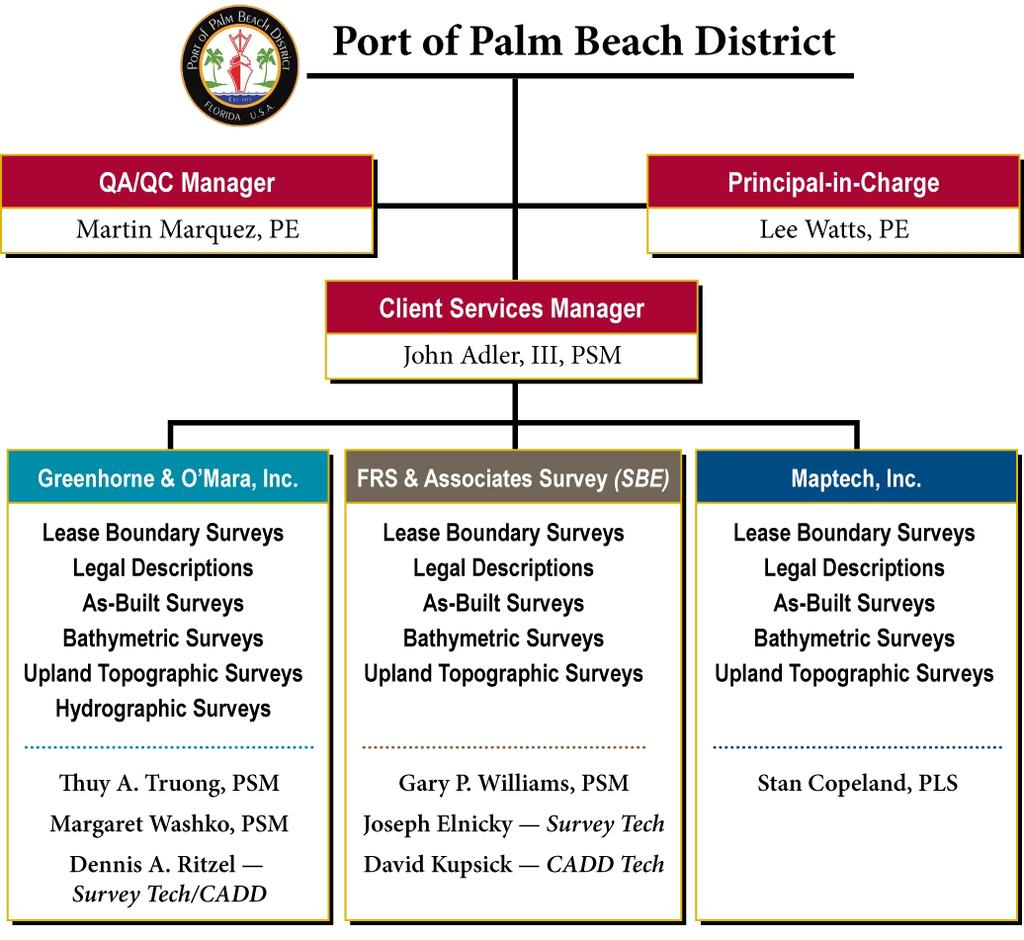
Introduction and Company Overview
|
|
|
- Raymond May
- 6 years ago
- Views:
Transcription

1

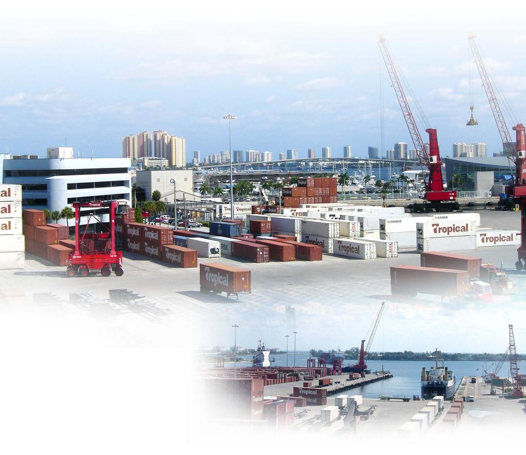
2 Introduction and Company Overview Multi-discipline consulting firm Founded in HQ in Laurel, Maryland Local WPB Office Survey, Utility Coordination, Roadway Design, Environmental and CEI Past Port of Palm Beach Experience Skypass Bridge CEI & Survey Phases 5 & 6 Parking Lot Expansions CEI & Survey Slip No. 1 (Old Slip No. 3) Expansion CEI & Survey
3
 Cadastral Surveys CEI Surveys Condominium Plats Construction Layout Surveys")
4 Greenhorne & O Mara, Inc. Surveying Services Offering the following services: ALTA/ACSM Land Title Surveys Asbuilt Surveys Boundary Surveys (Lease) Cadastral Surveys CEI Surveys Condominium Plats Construction Layout Surveys Elevation Certifications Geodetic Control Global Positioning Surveys (GPS) Hazardous Waste Surveys Hydrographic Surveys Topographic Surveys Transportation Design Surveys Sub-Surface Utility Excavation Laser Scanning Legal Descriptions & Sketch Mean High Water Survey Right of Way Survey Right of Way Mapping Quantity Surveys


5 Specialized Equipment for Topographic Surveys and Underground Utility Location Leica HDS3000 Laser Scanner Surface Utility Locator Ground Penetrating Radar Utility Vacuum

6 Port Lease Boundaries
7 Experience in Hydrographic Surveys Maptech has over twenty-five (25) years experience in conducting hydrographic surveys. A few representative clients are as follows: Federal and State Agencies South Florida Water Management District U.S. Army Corps of Engineers, Jacksonville District U.S. Army Corps of Engineers, Mobile District Florida Department of Transportation Florida Department of Environmental Protection Florida Inland Navigation District University of Florida Local Government Palm Beach County Town of Palm Beach Broward County Collier County Dade County City of Sanibel
8 Experience in Hydrographic Surveys Maptech has conducted numerous hydrographic surveys for a multitude of applications including: Preconstruction engineering and design phase Construction monitoring Operation and maintenance (monitoring phase) Dredging measurement and payment surveys Plans and specifications surveys. Before and after dredging surveys Project Condition Surveys. River stabilization project surveys. Underwater obstruction or condition surveys. Coastal engineering surveys. Reservoir, canal and lake sedimentation surveys Inland navigation charting surveys. Wetland surveys.


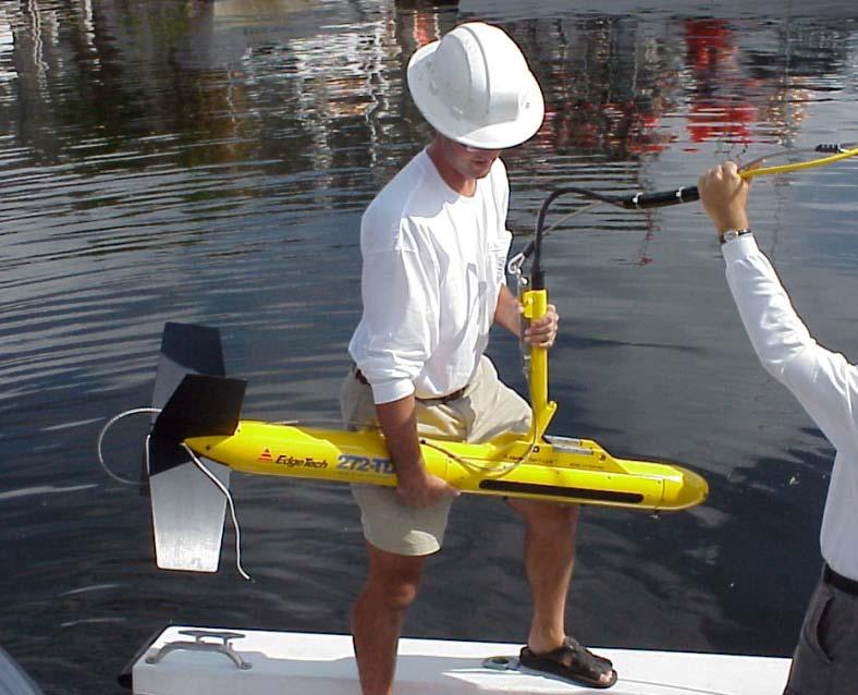
9 Company owned Hydrographic Survey Equipment and Software Maptech maintains a fleet of hydrographic survey vessels to support fully automated hydrographic survey operations. 22 Fully Equipped Survey Vessel 17 Pontoon Boat Several Small Vessels(12 to 18 )


10 Company owned Hydrographic Survey Equipment and Software Maptech maintains a full compliment of state of the art positioning and sounding equipment, including a complete sub-bottom systems. Trimble RTK/OTF Real Time Tides Multi-Beam Systems for 100% Coverage (via agreement) Heave, Pitch and Roll Compensation High Accuracy 200kHz Fathometer Dual Frequency (Sub- Bottom) Fathometer

11 Recent Hydrographic Surveys Completed By Maptech Class I Automated Hydrographic Survey - 2 Inlets, 6 Borrow Areas, 7 Beach Restoration Segments (Program. Pre- and Post Construction Surveys)

12 Recent Hydrographic Surveys Completed By Maptech Class I Automated Hydrographic Survey for 15 Miles of the Miami River Restoration Program. Pre- and Post Construction Surveys.

13 Recent Hydrographic Surveys Completed By Maptech Class I Automated Hydrographic Survey of a portion of the Port for the Corps of Engineers
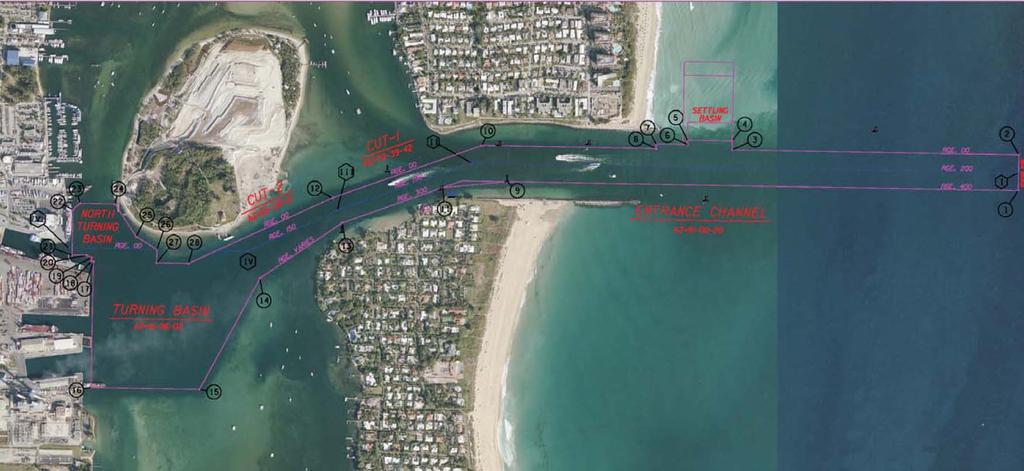
14 Familiar With the Configuration of the Port s Entrance Channel, Turning Basin & Settling Basin
15 Quality Assurance for Hydrographic Surveys. Maptech personnel are professionally trained in the acquisition and processing of Hydrographic Surveys. This includes: Positioning system calibration Fathometer calibration Data acquisition software (HyPack) The following Engineering Manual is utilized by Maptech to provide our clients with the highest accuracy in Hydrographic Surveys: EM January 2001 US Army Corps of Engineers ENGINEERING AND DESIGN Hydrographic Surveying This Technical Manual provides United States Army Corps of Engineers policy and guidance for acquisition, calibration, quality control, and quality assurance of hydrographic survey system.

16 Side Scan Sonar and Magnetometer Surveys

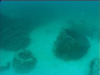
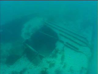
17 Side Scan Sonar and Magnetometer Surveys (Shipwreck Off Broward County)


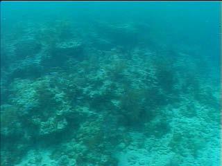
18 Side Scan Sonar and Magnetometer Surveys (Near Shore Reef)
19 10 Reason Why the Port of Palm Beach Should Chose the Greenhorne &O Mara Team Port Experience Location less then 15 Minutes from the Port Proven Leader on Task Order Contracts Experience providing the Scope of Services Specialized Services SUE & Laser Scanning 20 years of Hydrographic Experience in the Lake Worth Inlet Current Hydrographic Data Set of Lake Worth Inlet Immediate Response Pre & Post Storm Event Available Staff Provide Professional Services in Timely and Cost-effective Manner
20 Questions?
EGYPTIAN HYDROGRAPHIC DEPARTMENT ENHD. The ENHD following by the chain of command the Egyptian Naval HQ.
 ENHD gvt 4/7/2015 1 ENHD The ENHD following by the chain of command the Egyptian Naval HQ. Considered one of the oldest and the most experienced hydrographic office in the region (since 1920). ENHD is
Stakeholder Meeting #1. An Introduction to the Blind Pass Inlet Management Study
 Stakeholder Meeting #1 An Introduction to the Blind Pass Inlet Management Study April 21, 2016 5:30 PM, The Sanctuary, Sanibel Island A World of Solutions 0 Agenda Introductions Study Overview Study Status
2017 and Beyond Forecasted Acquisition Strategy- Jacksonville District Updated 17 Mar 2017
 and Beyond Forecasted Acquisition Strategy- Jacksonville District Updated 17 Mar DISCLAIMER: The forecast data is for planning purposes, does not represent a presolicitation synopsis, does not constitute
Proposed Cherry Grove Canals Dredging Project
 Proposed Cherry Grove Canals Dredging Project 1 Development of Cherry Grove C.D. Nixon inherited 9,940 acres of land 1924 Nixon family began planning subdivision of Cherry Grove 1950 Mr. Nixon closed natural
Active Geodetic Network of Serbia
 Active Geodetic Network of Serbia Oleg ODALOVIC and Ivan ALEKSIC, Serbia Key words: GPS, AGROS, RINEX, RTCM SUMMARY In June 2003 the Republic Geodetic Authority (RGZ) has started the realization of the
A Brief History of the Town of Palm Beach Coastal Protection Program. Beach nourishment occurred in Palm Beach as far back as the 1940s.
 A Brief History of the Town of Palm Beach Coastal Protection Program Beach nourishment occurred in Palm Beach as far back as the 1940s. The Lake Worth Inlet Sand Transfer Plant was built in the late 1950s.
March 2, The Honorable Mayor Williams D. Sessoms, Jr. Members of City Council. Subject: Coastal CIP Presentation to City Council - March 6, 2018
 OFFICE OF THE CITY MANAGER (757) 385-4242 (757) 427-5626 FAX MUNICIPAL CENTER BUILDING 1, ROOM 234 2401 COURTHOUSE DRIVE VIRGINIA BEACH, VA 23456-9001 March 2, 2018 The Honorable Mayor Williams D. Sessoms,
BANGLADESH NATIONAL HYDROGRAPHIC REPORT FOR THE 13 TH NIOHC MEETING
 BANGLADESH NATIONAL HYDROGRAPHIC REPORT FOR THE 13 TH NIOHC MEETING YANGON, MYANMAR 19-22 FEBRUARY 2013 1 CONTENTS 1. Hydrographic Office 2. Surveys 3. New Charts & Updates 4. New Publications & Updates
Atlantic Surveying, P.A. Professional Land Surveyors
 A S Atlantic Surveying, P.A. Professional Land Surveyors 111 S. Queen Street Kinston, N.C. 28501 (252) 527-6994 Fax: (252) 522-0139 Email: wcbutler@embarqmail.com fwdavenport@embarqmail.com Established
CORPS OF ENGINEERS ALASKA DISTRICT Dredging Projects. Michael Tencza, PE Operations Project Manager November 4, 2015
 CORPS OF ENGINEERS ALASKA DISTRICT 2016 Dredging Projects Michael Tencza, PE Operations Project Manager November 4, 2015 US Army Corps of Engineers Building and Preserving Alaska s Future AWARDED CONTRACTS
BARBADOS NATIONAL REPORT
 BARBADOS NATIONAL REPORT TO THE 10 TH MEETING OF THE MESO-AMERICA AND CARIBBEAN HYDROGRAPHIC COMMISSION BRIDGETOWN, BARBADOS 3 RD 6 TH NOVEMBER 2009 HYDROGRAPHIC OFFICE: Establishment Barbados is an associate
XVII MESO AMERICAN AND CARIBBEAN SEA HYDROGRAPHIC COMMISSION MEETING, BELEM, BRASIL
 XVII MESO AMERICAN AND CARIBBEAN SEA HYDROGRAPHIC COMMISSION MEETING, BELEM, BRASIL 2016 2. HYDROGRAPHIC SURVEYS NEW HYDROGRAPHIC SURVEYS WITH CARTOGRAPHIC PURPOSES EQUIPMENT Single beam echosounders Single
Water Resources Update after NCGA Long Session
 Water Resources Update after NCGA Long Session North Carolina Beach Inlet & Waterway Association Annual Conference November 16, 2015 Division of Water Resources Overview New Name / Reorganization Jordan
PORT EVERGLADES SAND BYPASS PROJECT
 28 th Annual National Conference on Beach Preservation Technology February 4, 2015 Clearwater Beach, FL PORT EVERGLADES SAND BYPASS PROJECT AN IMPORTANT FUTURE SAND SOURCE FOR SOUTHEAST FLORIDA BEACHES
Datum Issues in the Red River of the North Basin ----
 Datum Issues in the Red River of the North Basin ---- Scoping Document May 1999 Russell E. Harkness, Hydrologist United States Geological Survey Water Resources Division 2 EXECUTIVE SUMMARY Two datum issues
Aerodrome Manual. ICAO/FAA Comprehensive Aerodrome Certification Inspector Workshop. Presented To: Caribbean States By: FAA Office of Airports
 ICAO/FAA Comprehensive Aerodrome Certification Inspector Workshop Presented To: Caribbean States By: FAA Office of Airports OBJECTIVE Development of an Aerodrome Manual (AM). 2 ICAO ANNEX 14 - SECTION
7/21/2014. New Jersey Waterway Debris Removal from Superstorm Sandy: Unprecedented! Superstorm Sandy. Superstorm Sandy.
 New Jersey Waterway Debris Removal from Superstorm Sandy: Unprecedented! Superstorm Sandy Image courtesy of Remik Ziemlinski, Climate Central (www.climatecentral.org) 2 New Jersey Waterway Debris Removal
REPUBLIC OF MOZAMBIQUE
 SAIHC14-5.4F REPUBLIC OF MOZAMBIQUE INSTITUTO NACIONAL DE HIDROGRAFIA E NAVEGAÇÃO NATIONAL REPORT TO THE 14 th SOUTHERN AFRICA AND ISLANDS HYDROGRAPHIC COMMISSION CONFERENCE Saint-Gilles La Réunion 6 th
Port Everglades Master/Vision Plan Update
 Port Everglades Master/Vision Plan Update Environmental Stakeholder Meeting June 15, 2009 Discussion to Focus On: Updating the 2006 Port Everglades Master Plan Issues dealing with the Turning Notch Potential
Background to the Article 83 bis Task Force
 Article 83 bis Background to the Article 83 bis Task Force At the 35th Session the Secretariat reported on difficulties States encounter in implementing Article 83 bis. The Committee established a Working
Austin-Bergstrom International Airport Master Plan Update
 FINAL REPORT Prepared for: City of Austin Department of Aviation 3600 Presidential Boulevard Austin, Texas 78719 Prepared by: P&D Aviation A Division of P&D Consultants, Inc. 999 Town & County Road, 4
Solomon Islands Maritime Safety Administration
 SI M SA Solomon Islands Maritime Safety Administration Solomon Islands Government SOLOMON ISLANDS HYDROGRAPHIC UNIT National Report for the 13 th SOUTH WEST PACIFIC HYDROGRAPHIC COMMISSION MEETING RAROTONGA,
Port Everglades Receives Federal Authorization to Deepen and Widen Channels
 Port Everglades Receives Federal Authorization to Deepen and Widen Channels President Obama Signs Water Infrastructure Improvements for the Nation (WIIN) Act See bottom of release for caption and link
Hazard Identification Questionnaire
 Hazard Identification Questionnaire OVERVIEW This questionnaire is designed to help identify potential risks and help identify areas of risk exposure. It is not an exhaustive list. This questionnaire is
St. Augustine Port, Waterway & Beach District. St. Augustine Inlet 2013 draft Inlet Management Plan. March 19, 2013
 Division of Water Resource Management St. Augustine Port, Waterway & Beach District St. Augustine Inlet 2013 draft Inlet Management Plan March 19, 2013 Discussion Outline Florida Statutes Florida Inlets
RULES OF TENNESSEE DEPARTMENT OF TRANSPORTATION AERONAUTICS DIVISION CHAPTER LICENSING AND REGISTRATION OF AIRPORTS TABLE OF CONTENTS
 RULES OF TENNESSEE DEPARTMENT OF TRANSPORTATION AERONAUTICS DIVISION CHAPTER 1680-1-2 LICENSING AND REGISTRATION OF AIRPORTS TABLE OF CONTENTS 1680-1-2-.01 Purpose 1680-1-2-.06 Repealed 1680-1-2-.02 Definitions
agis a brief overview
 agis a brief overview Steve Welebny Photogrammetrist Keystone Aerial Surveys Villanova University 1 Villanova University 2 Nav Aid Cost VOR Install = $250,000 20 year life cycle cost = $1,100,000 ILS Install
City of Fort Lauderdale. Frequently Asked Questions. Proposed Sea Wall Ordinance
 City of Fort Lauderdale Frequently Asked Questions Proposed Sea Wall Ordinance The City of Fort Lauderdale is considering amending the Unified Land Development Regulations of the City of Fort Lauderdale
SACAL COMPANY PROFILE
 STRATEGIC AVIATION CONSULTANTS & ADVISORS, LTD. (603) 553-8001 POST OFFICE BOX 1873 www.sacal.aero MERRIMACK, NEW HAMPSHIRE 03054-1873 USA info@sacal.aero SACAL COMPANY PROFILE OVERVIEW SACAL is a diversified
AUGUST 2017 GNSS REVIEW. Survey Economics Chances of success. Mobile Mapping Airport scanning. Stag s Leap Winery Pre-construction plan
 AUGUST 2017 GNSS REVIEW Survey Economics Chances of success Stag s Leap Winery Pre-construction plan Mobile Mapping Airport scanning RISING PERFORMANCE» ERIK DAHLBERG Civil aviation is an outlier. It s
RISING PERFORMANCE. Civil aviation is an outlier. It s BY ERIK DAHLBERG
 RISING PERFORMANCE Compact mobile mapping systems can be installed on small passenger cars. Civil aviation is an outlier. It s among the few industries where tight government regulations are widely accepted
XVII MESO AMERICAN AND CARIBBEAN SEA HYDROGRAPHIC COMMISSION MEETING, BELEM, BRASIL
 XVII MESO AMERICAN AND CARIBBEAN SEA HYDROGRAPHIC COMMISSION MEETING, BELEM, BRASIL 2016 2. HYDROGRAPHIC SURVEYS NEW HYDROGRAPHIC SURVEYS WITH CARTOGRAPHIC PURPOSES EQUIPMENT Single beam echosounders
5 Day Operator Course. 1.0 AIRSPACE CLASSROOM ONLINE EXECUTIVE VO Terms X X Classification
 5 Day Operator Course 2 Day Executive Training 2 Day VO Training 0.1 INTRODUCTION CLASSROOM ONLINE EECUTIVE VO About Avion Solutions Purpose of the course Learning objectives Course outline and schedule
CIVIL AVIATION AUTHORITY, PAKISTAN OPERATIONAL CONTROL SYSTEMS CONTENTS
 CIVIL AVIATION AUTHORITY, PAKISTAN Air Navigation Order No. : 91-0004 Date : 7 th April, 2010 Issue : Two OPERATIONAL CONTROL SYSTEMS CONTENTS SECTIONS 1. Authority 2. Purpose 3. Scope 4. Operational Control
NEW TECHNOLOGIES AND THEIR IMPACT ON PORT DEVELOPMENT IN JAMAICA. Christopher Hamilton May
 Organization Of American States Second Hemispheric Conference On Inland Ports, Waterways & Dredging NEW TECHNOLOGIES AND THEIR IMPACT ON PORT DEVELOPMENT IN JAMAICA Christopher Hamilton May 18 2017 2.83
Stakeholders Meeting
 Stakeholders Meeting for the Expansion of Runway 9R-27L, Terminal 4 Gate Relocation and Land Acquisition for Runway 9R-27L September 22, 2011 Stakeholders Meeting AGENDA Introduction FLL Airport Improvements
NC Dredge Studies NCBIWA Spring Conference April 23, 2018
 NC Dredge Studies Study of the Use and Efficiency of the Dredge Manteo Study of Acquisition of Dedicated Dredging Capacity Study of Dredging Services Cost-Benefit Analysis 2018 NCBIWA Spring Conference
NC Dredge Studies. Sterling Baker, P.E. NCDOT James Gregson NCDEQ April 5, 2018
 NC Dredge Studies Study of the Use and Efficiency of the Dredge Manteo Study of Acquisition of Dedicated Dredging Capacity Study of Dredging Services Cost-Benefit Analysis Sterling Baker, P.E. NCDOT James
Waterways Council November 10, 2017
 Waterways Council November 10, 2017 MULTI-PURPOSE LANDLORD PORT The Port of New Orleans generates its own revenues as a multipurpose landlord port. Cargo 69%; cruise 21%; real estate 10% Diversity increases
The History & Management of the Atlantic Intracoastal Waterway in Florida
 The History & Management of the Atlantic Intracoastal Waterway in Florida THE BEGINNING OF THE INTRACOASTAL WATERWAY IN FLORIDA CONSTRUCTED BY A PRIVATE COMPANY, THE FLORIDA EAST COAST CANAL COMPANY BETWEEN
Potential Application of. Shore-Stabilizing Structures along an Open-Coast Shoreline. Christopher G. Creed, P.E. 23 rd Annual National Conference on
 23 rd Annual National Conference on Potential Application of Beach Preservation Technology February 3-5, 2010 Indialantic, FL Shore-Stabilizing Structures along an Open-Coast Shoreline Christopher G. Creed,
1.0 Project Background Mission Statement and Goals Objectives of this Sustainable Master Plan
 TABLE OF CONTENTS CHAPTER 1 INTRODUCTION 10 Project Background 1-1 11 Mission Statement and Goals 1-1 12 Objectives of this Sustainable Master Plan 1-2 CHAPTER 2 INVENTORY 20 Airport Background 2-1 201
Rapid Maritime Response
 Rapid Maritime Response presented to 13 th MACHC Katie Ries Coast Survey is set up for rapid maritime response Navigation managers coordinate activities and assets with Coast Guard, port officials,
THE REAPPEARANCE OF THE DANTON
 THE REAPPEARANCE OF THE DANTON MV Geo Prospector Operations In December 2007, the Fugro survey vessel Geo Prospector was performing part of the Detailed Marine Survey for routing the proposed Galsi gas
Wide Area Augmentation System (WAAS) and Local Area Augmentation System (LAAS) Update
 and Local Area Augmentation System (LAAS) Update") Wide Area Augmentation System (WAAS) and Local Area Augmentation System (LAAS) Update Presented to: By: Date: CGSIC Leo Eldredge, FAA September 24, 2008 Agenda WAAS Architecture WAAS Services Overview
Wide Area Augmentation System (WAAS) and Local Area Augmentation System (LAAS) Update Presented to: By: Date: CGSIC Leo Eldredge, FAA September 24, 2008 Agenda WAAS Architecture WAAS Services Overview
Regional implementation of Electronic Terrain and Obstacle data (e-tod) (Presented by Jeppesen)
 (Presented by Jeppesen)") International Civil Aviation Organization SAM/IG/13-WP/39 South American Regional Office 5/04/14 Thirteenth Workshop/Meeting of the SAM Implementation Group English only (SAM/IG/13) - Regional Project
International Civil Aviation Organization SAM/IG/13-WP/39 South American Regional Office 5/04/14 Thirteenth Workshop/Meeting of the SAM Implementation Group English only (SAM/IG/13) - Regional Project
Taisei MORISHITA, Hiroaki SAITO and Shin TANI Hydrographic and Oceanographic Department (JHOD) Japan Coast Guard
 Japan Coast Guard") Taisei MORISHITA, Hiroaki SAITO and Shin TANI Hydrographic and Oceanographic Department (JHOD) Japan Coast Guard 1. Earthquake and Tsunami (review) 2. JHOD s Response Activities (overview) 3. Hydrographic
Taisei MORISHITA, Hiroaki SAITO and Shin TANI Hydrographic and Oceanographic Department (JHOD) Japan Coast Guard 1. Earthquake and Tsunami (review) 2. JHOD s Response Activities (overview) 3. Hydrographic
Glossary and Acronym List
 AFS Safety Assurance System (SAS) Overview Glossary and Acronym List This document lists and defines many SAS acronyms and terms. This is not intended to be a complete list of terms and definitions. TERM
VISION SURVEYS (QLD) CAPABILITY STATEMENT YOUR VISION OUR GOAL
 CAPABILITY STATEMENT YOUR VISION OUR GOAL") YOUR VISION OUR GOAL Experts in Project Coordination, Land Surveying, Town Planning, 3D Spatial, Civil & Mining Infrastructure VISION SURVEYS (QLD) CAPABILITY STATEMENT VISIONSURVEYSQLD.COM.AU 13000 VISION
YOUR VISION OUR GOAL Experts in Project Coordination, Land Surveying, Town Planning, 3D Spatial, Civil & Mining Infrastructure VISION SURVEYS (QLD) CAPABILITY STATEMENT VISIONSURVEYSQLD.COM.AU 13000 VISION
Leaders in independent airworthiness management services. flyertech.com
 Leaders in independent airworthiness management services / AIRWORTHINESS MANAGEMENT SERVICES. We are an independent Continuing Airworthiness Management Organisation. We are the world leaders in providing
UAS to GIS Utilizing a low-cost Unmanned Aerial System (UAS) for Coastal Erosion Monitoring
 for Coastal Erosion Monitoring") UAS to GIS Utilizing a low-cost Unmanned Aerial System (UAS) for Coastal Erosion Monitoring Agenda Scope of today s presentation Demonstration Objectives Wrightsville Beach Test Area Masonboro Inlet Jetties
UAS to GIS Utilizing a low-cost Unmanned Aerial System (UAS) for Coastal Erosion Monitoring Agenda Scope of today s presentation Demonstration Objectives Wrightsville Beach Test Area Masonboro Inlet Jetties
3D SURVEYING AND VISUALIZATION OF THE BIGGEST ICE CAVE ON EARTH
 CO-015 3D SURVEYING AND VISUALIZATION OF THE BIGGEST ICE CAVE ON EARTH BUCHROITHNER M.F., MILIUS J., PETTERS C. Dresden University of Technology, DRESDEN, GERMANY ABSTRACT The paper deals with the first
MESO-AMERICAN AND CARIBBEAN HYDROGRAPHIC COMMISSION. National Report (October 2006) - Jamaica
 - Jamaica") MESO-AMERICAN AND CARIBBEAN HYDROGRAPHIC COMMISSION National Report (October 2006) - Jamaica 1. HYDROGRAPHIC OFFICE: Reorganization Jamaica is a member State of the IHO and the Meso-America and Caribbean
MESO-AMERICAN AND CARIBBEAN HYDROGRAPHIC COMMISSION National Report (October 2006) - Jamaica 1. HYDROGRAPHIC OFFICE: Reorganization Jamaica is a member State of the IHO and the Meso-America and Caribbean
COMMONWEALTH OF THE BAHAMAS MINISTRY OF PUBLIC WORKS & TRANSPORT NASSAU HARBOUR PORT IMPROVEMENT PROJECT. Nassau Harbour Port Improvement Project
 COMMONWEALTH OF THE BAHAMAS MINISTRY OF PUBLIC WORKS & TRANSPORT NASSAU HARBOUR PORT IMPROVEMENT PROJECT AUGUST 2009 OVERALL VIEW OF NASSAU HARBOUR AERIAL VIEW OF NASSAU HARBOUR PROJECT HISTORY 1960 s
Riverine Sand Mining/Scofield Island Restoration (BA-40)
") Riverine Sand Mining/Scofield Island Restoration (BA-40) Conference on Ecological and Ecosystem Restoration Kenneth Bahlinger, CPRA Project Manager July 31, 2014 committed to our coast committed to our
Riverine Sand Mining/Scofield Island Restoration (BA-40) Conference on Ecological and Ecosystem Restoration Kenneth Bahlinger, CPRA Project Manager July 31, 2014 committed to our coast committed to our
Restoration History Of Anitra Thorhaug, Phd.
 Restoration History Of Anitra Thorhaug, Phd.. 1.) FIRST LARGE SCALE SEAGRASS RESTORATION. Nuclear Power Plant. Turkey Point, Biscayne Bay, Florida after the plant went to an alternate cooling system 2.)
Ports. Water and Environment Solutions
 Ports Water and Environment Solutions BMT WBM in Ports The Company BMT WBM and Ports BMT WBM Pty Ltd is a leading edge water and environmental consultancy with more than 40 years national and international
Staff Report on Brevard County Area Projects (See pages 32-60) Staff will present a report on District Projects in the Brevard County area.
 Staff will present a report on District Projects in the Brevard County area.") Call to Order - Chair Netts will call the meeting to order. Pledge of Allegiance - Commissioner Sansom will lead the Pledge of Allegiance. Roll Call - Secretary Gernert will call the roll. Additions or
Call to Order - Chair Netts will call the meeting to order. Pledge of Allegiance - Commissioner Sansom will lead the Pledge of Allegiance. Roll Call - Secretary Gernert will call the roll. Additions or
Waterway Access and the Atlantic Intracoastal Waterway in Florida
 Waterway Access and the Atlantic Intracoastal Waterway in Florida Issues: Maintenance - Funding (costs), Infrastructure needs, permitting Management Consideration of the M-95 system, Cooperation among
Coastal Management: Treasure Island - Long Key Nourishment
 Coastal Management: Treasure Island - Long Key Nourishment Project Completed - October 20, 2010 The nourishment of Treasure Island and Long Key (TI/LK) beaches began in late July of 2010. The previous
SEATTLE AIR ROUTE TRAFFIC CONTROL CENTER SEATTLE GLIDER COUNCIL LETTER OF AGREEMENT. EFFECTIVE: June 1, 2015
 SEATTLE AIR ROUTE TRAFFIC CONTROL CENTER SEATTLE GLIDER COUNCIL LETTER OF AGREEMENT EFFECTIVE: June 1, 2015 SUBJECT: GLIDER OPERATIONS WITHIN CLASS A AIRSPACE 1. PURPOSE. This Letter of Agreement establishes
Annual Port Review. June 22, 2016
 Annual Port Review June 22, 2016 2 Port Everglades by the Numbers (FY2015 unless indicated) #1 Seaport in Florida by Revenue - $153 million #1 Container Port in Florida - (#10 in U.S.) by volume 1,060,507
The Trusts Dredging Strategy
 NAG Meeting 21st September 2012 Graham Holland Head of Asset Management Current Review Why Now? Previous practices not always well defined Processes required greater clarity The need to apply asset management
FLL Master Plan Update Technical Advisory Committee (TAC) Briefing #1. September 28, 2016
 Briefing #1. September 28, 2016") FLL Master Plan Update Technical Advisory Committee (TAC) Briefing #1 September 28, 2016 TAC Committee Role: Internal Stakeholders To provide input on the master planning analysis from the technical and
FLL Master Plan Update Technical Advisory Committee (TAC) Briefing #1 September 28, 2016 TAC Committee Role: Internal Stakeholders To provide input on the master planning analysis from the technical and
Using LiDAR for Precise Vegetation Management
 Using LiDAR for Precise Vegetation Management Quantum Spatial is a proven partner to airport planners, engineers, facility managers, and contractors whose objective is to build, expand, and make improvements
BELFAST MUNICIPAL AIRPORT OVERVIEW
 BELFAST MUNICIPAL AIRPORT OVERVIEW LOCATION AND HISTORY Belfast Municipal Airport (Federal Aviation Administration (FAA) airport code BST, International Civil Aviation Organization airport code KBST, FAA
Buffalo District Navigation Program Overview
 Buffalo District Navigation Program Overview 16 FEB 2011 US Army Corps of Engineers Buffalo District Area of Operations Our Facilities District Headquarters 2 Area Offices 3 Regulatory Field Offices Lake
 Existing Conditions AIRPORT PROFILE Passenger Terminal Complex 57 air carrier gates 11,500 structured parking stalls Airfield Operations Area 9,000 North Runway 9L-27R 6,905 Crosswind Runway 13-31 5,276
OVERSEAS TERRITORIES AVIATION REQUIREMENTS (OTARs)
") OVERSEAS TERRITORIES AVIATION REQUIREMENTS (OTARs) Part 171 AERONAUTICAL TELECOMMUNICATION SERVICES Published by Air Safety Support International Ltd Air Safety Support International Limited 2005 First
OVERSEAS TERRITORIES AVIATION REQUIREMENTS (OTARs) Part 171 AERONAUTICAL TELECOMMUNICATION SERVICES Published by Air Safety Support International Ltd Air Safety Support International Limited 2005 First
Sava Commission Activities. KICK-OFF MEETING DANTE, February 17, 2017, Budapest
 Sava Commission Activities KICK-OFF MEETING DANTE, February 17, 2017, Budapest 1 Establishment of the ISRBC 2 Decay of SFRY a challenge to WRM in the Sava river basin Sava river used to be the biggest
Pro Line Fusion integrated avionics system. Pro Line Fusion on Embraer Legacy 450 and 500: Business-jet technology designed with tomorrow in mind.
 Pro Line Fusion on Embraer Legacy 450 and 500: Business-jet technology designed with tomorrow in mind. Your Pro Line Fusion flight deck provides a broad range of baseline capabilities that maximize the
Airport Safety Management Systems: Integrating Planning Into the Process
 Airport Safety Management Systems: Integrating Planning Into the Process Kenneth Jacobs Senior Airport Planner FAA Airport Planning and Environmental Division ken.jacobs@faa.gov SMS Defined A process for
Project Data Sheet BASIC PROJECT DATA. Improvement of the systems for navigation and topo-hydrographic measurements on the Danube River
 BASIC PROJECT DATA Full project title: Short project title: (acronym) Improvement of the systems for navigation and topo-hydrographic measurements on the Danube River Project logo: Project website: Project
Tri-Rail Coastal Link and Downtown Miami Link. Miami-Dade County Black Affairs Advisory Board February 3, 2016
 Tri-Rail Coastal Link and Downtown Miami Link Miami-Dade County Black Affairs Advisory Board February 3, 2016 Current Tri-Rail Service Miami Int l Airport 72 mile system Now 18 stations 50 trains per weekday
Cat Island Chain Background & Access Guide
 Cat Chain Background & Access Guide Brown County Port & Resource Recovery Department 2561 S. Broadway, Green Bay, WI 54304 (920) 492-4950 www.portofgreenbay.com January 2018 1 Restoration of the Cat Chain
9/16/ CHG 213 VOLUME 3 GENERAL TECHNICAL ADMINISTRATION CHAPTER 61 AIRCRAFT NETWORK SECURITY PROGRAM
 VOLUME 3 GENERAL TECHNICAL ADMINISTRATION CHAPTER 61 AIRCRAFT NETWORK SECURITY PROGRAM Section 1 Safety Assurance System: Evaluate the Operator s 14 CFR Parts 121, 121/135, 125, and 129 Aircraft Network
Considerations for Facility Consolidation
 Considerations for Facility Consolidation ATC Guild, New Delhi, India October 21, 2010 Mimi Dobbs Overview Why consider consolidation? Co location vs Consolidation Consolidating Methodologies Areas to
2.0 Miami-Dade Transit System Overview
 2.0 Miami-Dade Transit System Overview Miami-Dade Transit operates the 14 th largest transit system in the United States and is the largest transit system in the State of Florida. MDT is one of the largest
ICAO Aerodrome s Manual. AERODROME S INSPECTOR WORKSHOP St. Maarten, MAHO June 2012
 ICAO Aerodrome s Manual AERODROME S INSPECTOR WORKSHOP St. Maarten, MAHO 11-15 June 2012 Objectives - Identify the requirements listed in Annex 14 regarding the development and maintenance of an aerodrome
Airport Master Plan Update June 15, 2017
 Airport Master Plan Update June 15, 2017 www.harveyfield.com The Master Plan is a 20-year plan to understand the needs of current and future users of the Airport. This is important to ensure that safe
Airport Master Plan Update June 15, 2017
 Airport Master Plan Update June 15, 2017 www.harveyfield.com The Master Plan is a 20-year plan to understand the needs of current and future users of the Airport. This is important to ensure that safe
PORT OF SEATTLE MEMORANDUM. COMMISSION AGENDA Item No. 4g ACTION ITEM Date of Meeting February 9, 2016
 PORT OF SEATTLE MEMORANDUM COMMISSION AGENDA Item No. 4g ACTION ITEM Date of Meeting February 9, 2016 DATE: TO: FROM: Michael Ehl, Director, Airport Operations Wayne Grotheer, Director, Aviation Project
The Corps of Engineers Dredges on the West Coast
 The Corps of Engineers Dredges on the West Coast Presented To California Marine Affairs and Navigation Conference Sheryl Carrubba Operations Manager, Channels & Harbors Portland District November 8, 2011
Shipwreck. Monitoring a Cruise. >> By Jack Lucic. Technology addresses the urgent safety needs for rescue and discovering why?
 Capsized off the Italian shore, the tragedy of the cruise ship Costa Concrdia generated global concern for the passengers. Monitoring a Cruise Shipwreck Technology addresses the urgent safety needs for
U.S. Coast Guard - American Waterways Operators Annual Safety Report
 American Waterways Operators U.S. Coast Guard - American Waterways Operators Annual Safety Report National Quality Steering Committee Meeting December 12, 2017 Established Safety Metrics For 17 years,
2012 Texas Water Conservation Association Meeting
 2012 Texas Water Conservation Association Meeting BG Thomas Kula Southwestern Division Commander 15 June 2012 US Army Corps of Engineers AGENDA UNCLASSIFIED Overview of Southwestern Division Missions Texas
Appendix A - Definitions
 Appendix A - Definitions Aeronautical Activity Any activity conducted at airports which involves, makes possible, or is required for the operation of aircraft, or which contributes to or is required for
Port Everglades. Presented to FMPOAC Freight Committee. July 23, 2015
 Port Everglades Presented to FMPOAC Freight Committee July 23, 2015 Port Overview Dania Beach Fort Lauderdale Hollywood Broward County Municipal Services District Port Everglades Overview Enterprise Fund
Drones in Construction: Beyond Pictures Capturing and Exploring Actionable Data
 Drones in Construction: Beyond Pictures Capturing and Exploring Actionable Data Hunter Cole & Jesse Creech Virtual Design + Construction Brasfield & Gorrie General Contractors Join the conversation #AU2016
Chapter 4.0 Alternatives Analysis
 Chapter 4.0 Alternatives Analysis Chapter 1 accumulated the baseline of existing airport data, Chapter 2 presented the outlook for the future in terms of operational activity, Chapter 3 defined the facilities
Table of Contents. Overview Objectives Key Issues Process...1-3
 Table of Contents Chapter One Introduction Overview...1-1 Objectives...1-1 Key Issues...1-2 Process...1-3 Chapter Two Inventory of Existing Conditions Airport Setting...2-1 Locale...2-1 Airport Surroundings...2-5
Abandoned Vessel & Structure Removal Program
 Abandoned Vessel & Structure Removal Program Texas General Land Office Oil Spill Prevention and Response Division Region 1 - Nederland, Texas TGLO Oil Spill Field Offices Austin, TX 1. Nederland, TX 2.
Collier County Airport Authority. Joint Automated Capital Improvement Program
 Collier County Airport Authority Joint Automated Capital Improvement Program Joint Automated Capital Improvement Program (JACIP) What is the JACIP? Financial planning process supported by Web-based computer
ECDIS Electronic Chart Display and Information Systems
 ECDIS Electronic Chart Display and Information Systems Jeff Lock, Master Mariner, Thomas Miller P&I We have come a long way from this.. To this IMO SOLAS V/19 1974 (as amended) Text from January 1 st 2011
City of Doral Flood Warning and Response Plan
 City of Doral Flood Warning and Response Plan Prepared by: City of Doral Public Works Department Stormwater Division City of Doral Flood Warning and Response Plan Flood events tend to pose a variety of
Official Journal of the European Union L 186/27
 7.7.2006 Official Journal of the European Union L 186/27 COMMISSION REGULATION (EC) No 1032/2006 of 6 July 2006 laying down requirements for automatic systems for the exchange of flight data for the purpose
Consideration will be given to other methods of compliance which may be presented to the Authority.
 Advisory Circular AC 139-10 Revision 1 Control of Obstacles 27 April 2007 General Civil Aviation Authority advisory circulars (AC) contain information about standards, practices and procedures that the
USACE GALVESTON DISTRICT PROJECT UPDATE
 USACE GALVESTON DISTRICT PROJECT UPDATE 255 255 255 237 237 237 0 0 0 217 217 217 163 163 163 200 200 200 DREDGE YOUR DOCKS 2018 131 132 122 239 65 53 80 119 27 110 135 120 252 174.59 112 92 56 62 102
INDUSTRIAL / BUSINESS PARK OPPORTUNITY
 INDUSTRIAL / BUSINESS PARK OPPORTUNITY FORT MYERS, FLORIDA WHAT S INSIDE: Development Location Page 1 Opportunity Details Page 2 Development Overview Page 3 Surrounding Area Pages 4-5 Additional Information
Aeronautical Satcom Markets
 Report Briefing Report Description NSR s Aeronautical Satcom Markets report answers the critical questions affecting the in-flight connectivity business. Based on NSR s extensive coverage and strong foundation