CRRT January 26, Christa G. von Hillebrandt-Andrade NOAA NWS Caribbean Tsunami Warning Program- Manager ICG CARIBE EWS Chair
|
|
|
- Rosamund Turner
- 6 years ago
- Views:
Transcription

1 17 CRRT January 26, 2017 Christa G. von Hillebrandt-Andrade NOAA NWS Caribbean Tsunami Warning Program- Manager ICG CARIBE EWS Chair
2 Institutional Reference Frame for the Exercise UNESCO: The United Nations Educational, Scientific, and Cultural Organization IOC: UNESCO Intergovernmental Oceanographic Commission ICG/CARIBE EWS: UNESCO IOC Intergovernmental Coordination Group for Tsunami and Other Coastal Hazards Warning System for the Caribbean and Adjacent Regions CTIC: Caribbean Tsunami Information Centre; A Government of Barbados UNESCO/ IOC Partnership NOAA: National Oceanic and Atmospheric Administration, U.S. Department of Commerce PTWC: NOAA Pacific Tsunami Warning Center (CARIBE EWS Tsunami Service Provider) CTWP: NOAA Caribbean Tsunami Warning Program CEPREDENAC: Coordination for Natural Disaster Prevention Center in Central America. CDEMA: Caribbean Disaster and Emergency Management Agency EMIZ Antilles: French WestIndies Zone Disaster Management Authority
3 CARIBE WAVE nations and 15 territories of the Caribbean and Adjacent Regions participated in this exercise with a total of 332,814 people engaged. This represented a MS participation rate of 100% (same as 2015, up from 98% in 2014, 94% in 2013, 75% in 2011) and an increase of individual participation of 74% (up from 191,420 in 2015).


4 Country Number of Participants, with post exercise updates from Member States Antigua & Barbuda 393 Bahamas 5 Barbados 1,860 Belize 27 Brazil 10 Colombia 137 Costa Rica 200 Cuba 633 Dominica 353 Dominican Republic 380 France 147 Grenada 14,300 Guadeloupe 62,928 Guatemala 10 Guyana 10 Haiti 260 Honduras 6 Martinique 21,731 Mexico 1,810 Netherlands 5 NL- Aruba 3 NL- Curacao 180 NL- Sint Maarten 1,400 Nicaragua 525 Panama 5,958 Saint Kitts and Nevis 3,320 Saint Lucia 560 Saint Martin 4,026 Saint Vincent and the Grenadines 35 Trinidad and Tobago 279 UK- Anguilla 1,160 UK- Bermuda 158 UK- British Virgin Islands 4,762 UK- Cayman Islands 20 UK- Turks and Caicos Islands 30 USA- Puerto Rico 140,875 USA- U.S. Virgin Islands 2,928 Venezuela 61,390 TOTAL 332,814
5 Feedback from CARIBE WAVE % of the Tsunami Warning Focal Points received the dummy message sent by the Pacific Tsunami Warning Center (PTWC). 51% of the survey respondents indicated that the exercise had media coverage. 86% of the TWFP/NDMO indicated that they had an activation and response process (standard operating procedures) in place for the receipt of tsunami warnings. Emergency response plan for tsunamis: 67% of participating countries had a plan for local tsunamis 68% of participating countries had a plan for regional tsunamis 71% of participating countries had a plan for distant tsunamis 17 Member States or their territories indicated that they had tsunami inundation maps. 29% of the TWFP/NDMO indicated that they had tsunami mass coastal evacuation plan.

6 According to the historical tsunami data base, over the past 500 years, at least 75 tsunamis have been observed in the region, and although they do not occur as frequently as in other basins, the vulnerability is very large; upwards of 500,000 people could be killed within hours if the response is not adequate. Map of tsunami run-ups in the Caribbean (National Centers for Environmental Information, Artist: Jessee Varner; originally published in von Hillebrandt-Andrade, 2013.
7 CARIBE WAVE 17

8 CARIBE WAVE 17 Earthquake and Tsunami Scenarios Scenario Origin Time Mw Epicenter Costa Rica ⁰, ⁰ Cuba ⁰, ⁰ 14:00:00 UTC March 21, 2017 Northeastern ⁰, ⁰ Lesser Antilles
9 Exercise Manuals The exercise manuals are available at The manual includes: Tsunami and earthquake scenarios description Timelines PTWC International dummy message and simulated exercise threat messages Travel times and expected wave heights The website link to post-exercise evaluation questionnaire
10 Appendix E. TWC Dummy (Start of Exercise) Messages INTERNATIONAL PTWC Center WECA41 PHEB WMO ID TSUCAX AWIPS ID TEST...TSUNAMI EXERCISE MESSAGE NUMBER 1...TEST NWS PACIFIC TSUNAMI WARNING CENTER/NOAA/NWS ISSUED AT 1400Z 21 MAR CARIBEWAVE 17 TSUNAMI EXERCISE MESSAGE. REFER TO PTWC MESSAGE 1 IN THE EXERCISE HANDBOOK. THIS IS AN EXERCISE ONLY... THIS MESSAGE IS BEING USED TO START THE CARIBEWAVE 17 CARIBBEAN TSUNAMI EXERCISE. THIS WILL BE THE ONLY EXERCISE MESSAGE BROADCAST FROM THE PACIFIC TSUNAMI WARNING CENTER EXCLUDING SPECIAL MESSAGES DISCUSSED IN THE HANDBOOK. THE HANDBOOK IS AVAILABLE AT THE WEB SITE CARIBEWAVE.INFO. THE EXERCISE PURPOSE IS TO PROVIDE EMERGENCY MANAGEMENT A REALISTIC SCENARIO TO TEST TSUNAMI RESPONSE PLANS. For the PTWC Domestic Dummy (very similar text), the header will be: THIS IS ONLY AN EXERCISE. WECA40 PHEB TSUCAR $$ It will be issued via FAX, , EMWIN, AWIPS and all normal Dissemination systems as with a real event.
11 Start of Exercise messages will also be sent out by PTWC twitter accounts Users with US Cellphone providers can receive Tweets as text messages, sending as body message: Follow NWS_PTWC to (this account is for all PTWC products) Follow NWS_CTWP to (this account is only for PTWC products for the Caribbean and Adjacent Regions) This is a test message for the CARIBEWAVE17 tsunami exercise #CaribeWave (will be issued at 14h00 UTC to NWS_PTWC and NWS_CTWP accounts/subcribers ).

12 Energy Forecast for Tsunami Wave Heights Costa Rica RIFT maximum amplitude map for the Southern Caribbean Sea based on the scenario for Costa Rica. During a real event this product will only be made available to officially designated Tsunami Warning Focal Points and National Tsunami Warning Centers.

13 Coastal Forecast for Tsunami Wave Heights Costa Rica RIFT coastal tsunami amplitude map for the Southern Caribbean Sea based on the scenario for Costa Rica. During a real event this product will only be made available to officially designated Tsunami Warning Focal Points and National Tsunami Warning Centers.

14 Energy Forecast for Tsunami Wave Heights Cuba RIFT maximum amplitude map for the Northwestern portion of the Caribbean Sea scenario for Cuba. During a real event this product will only be made available to officially designated Tsunami Warning Focal Points and National Tsunami Warning Centers.

15 Coastal Forecast for Tsunami Wave Heights Cuba RIFT coastal tsunami amplitude map for the Northwestern portion of the Caribbean Sea scenario for Cuba. During a real event this product will only be made available to officially designated Tsunami Warning Focal Points and National Tsunami.
16 Northeastern Lesser Antilles Scenario


17 Earthquake Impact Scenario Northeastern Lesser Antilles --- Earthquake Planning Scenario --- ShakeMap for Northeastern Antilles Scenario Scenario Date: Mar 21, :00:00 UTC M 8.5 N16.96 W60.69 Depth: 20.0km
18 Message Chronology issued by the PTWC Northeastern Lesser Antilles Date Time (UTC) PTWC Type of Product 3/21/ E a r t h q u a k e O c c u r s Transmission Method 3/21/ Dummy NWWS, GTS, EMWIN, AISR, Fax, 3/21/ Tsunami Threat Message #1 3/21/ Tsunami Threat Message # 2 and Graphic Enhanced Product 3/21/ Tsunami Threat Message #3 3/21/ Tsunami Threat Message #4 3/21/ Tsunami Threat Message #5 3/21/ Tsunami Threat Message #6 3/21/ Tsunami Threat Message #7 3/21/ Tsunami Threat Message #8 3/21/ Final Tsunami Threat Message #9
19 PTWC Simulated Domestic Products These will be issued only via to those agencies that are registered to receive the official products thru this mechanism (NWS SJFO, PRSEMA, PRSN) The simulated products will include: 14:05 UTC Advisory a couple of hours later 21:25 The EAS and NOAA Weather Radio will be activated (tested), NO test messages will be disseminated over WEA (Wireless Emergency Alerts), as would be the case for a real event.
20 Appendix F. TWC Exercise Messages Northeastern Antilles Earthquake Scenario The following messages created for the CARIBE WAVE 17 tsunami exercise are representative of the official standard products issued by the PTWC during a large magnitude 8.5 earthquake and tsunami originating in the Northeastern Antilles. During a real event, the TWCs would also issue graphical and html-based products to their web sites and via RSS. The alerts would persist longer during a real event than is depicted in this exercise. PTWC Message #1 ZCZC WECA41 PHEB WMO ID TSUCAX AWIPS ID TSUNAMI MESSAGE NUMBER 1 NWS PACIFIC TSUNAMI WARNING CENTER EWA BEACH HI 1405 UTC TUE MAR TSUNAMI THREAT MESSAGE... **** NOTICE **** NOTICE **** NOTICE **** NOTICE **** NOTICE ***** THIS MESSAGE IS ISSUED FOR INFORMATION ONLY IN SUPPORT OF THE UNESCO/IOC TSUNAMI AND OTHER COASTAL HAZARDS WARNING SYSTEM FOR THE CARIBBEAN AND ADJACENT REGIONS AND IS MEANT FOR NATIONAL AUTHORITIES IN EACH COUNTRY OF THAT SYSTEM. NATIONAL AUTHORITIES WILL DETERMINE THE APPROPRIATE LEVEL OF ALERT FOR EACH COUNTRY AND MAY ISSUE ADDITIONAL OR MORE REFINED INFORMATION. **** NOTICE **** NOTICE **** NOTICE **** NOTICE **** NOTICE ***** EVALUATION * AN EARTHQUAKE WITH A PRELIMINARY MAGNITUDE OF 8.3 OCCURRED IN THE LEEWARD ISLANDS AT 1400 UTC ON TUESDAY MARCH * BASED ON THE PRELIMINARY EARTHQUAKE PARAMETERS... WIDESPREAD HAZARDOUS TSUNAMI WAVES ARE POSSIBLE. TSUNAMI THREAT FORECAST * HAZARDOUS TSUNAMI WAVES FROM THIS EARTHQUAKE ARE POSSIBLE WITHIN THE NEXT THREE HOURS ALONG SOME COASTS OF MONTSERRAT... GUADELOUPE... DOMINICA... SAINT LUCIA... MARTINIQUE... ANTIGUA... BARBUDA... SINT EUSTATIUS... SAINT KITTS... SABA... BARBADOS... ANGUILLA... US VIRGIN IS... SAINT VINCENT... BR VIRGIN IS... SINT MAARTEN... PUERTO RICO... SAINT BARTHELEMY... SAINT MARTIN... GRENADA... DOMINICAN REP... TURKS N CAICOS... TRINIDAD TOBAGO... HAITI... BONAIRE... BAHAMAS... CUBA... ARUBA... VENEZUELA... BERMUDA... CURACAO... CAYMAN ISLANDS... COLOMBIA AND JAMAICA RECOMMENDED ACTIONS * GOVERNMENT AGENCIES RESPONSIBLE FOR THREATENED COASTAL AREAS SHOULD TAKE ACTION TO INFORM AND INSTRUCT ANY COASTAL POPULATIONS AT RISK IN ACCORDANCE WITH THEIR OWN EVALUATION... PROCEDURES AND THE LEVEL OF THREAT. * PERSONS LOCATED IN THREATENED COASTAL AREAS SHOULD STAY ALERT FOR INFORMATION AND FOLLOW INSTRUCTIONS FROM NATIONAL AND LOCAL AUTHORITIES. PRELIMINARY EARTHQUAKE PARAMETERS * MAGNITUDE 8.3 * ORIGIN TIME 1400 UTC MAR * COORDINATES 17.0 NORTH 60.7 WEST * DEPTH 40 KM / 25 MILES * LOCATION LEEWARD ISLANDS ESTIMATED TIMES OF ARRIVAL * ESTIMATED TIMES OF ARRIVAL -ETA- OF THE INITIAL TSUNAMI WAVE FOR PLACES WITHIN THE REGION IDENTIFIED WITH A POTENTIAL TSUNAMI THREAT. ACTUAL ARRIVAL TIMES MAY DIFFER AND THE INITIAL WAVE MAY NOT BE THE LARGEST. A TSUNAMI IS A SERIES OF WAVES AND THE TIME BETWEEN WAVES CAN BE FIVE MINUTES TO ONE HOUR.
21 LOCATION REGION COORDINATES ETA(UTC) PLYMOUTH MONTSERRAT 16.7N 62.2W /21 BASSE TERRE GUADELOUPE 16.0N 61.7W /21 ROSEAU DOMINICA 15.3N 61.4W /21 CASTRIES SAINT LUCIA 14.0N 61.0W /21 FORT DE FRANCE MARTINIQUE 14.6N 61.1W /21 SAINT JOHNS ANTIGUA 17.1N 61.9W /21 PALMETTO POINT BARBUDA 17.6N 61.9W /21 SINT EUSTATIUS SINT EUSTATIUS 17.5N 63.0W /21 BASSETERRE SAINT KITTS 17.3N 62.7W /21 SABA SABA 17.6N 63.2W /21 BRIDGETOWN BARBADOS 13.1N 59.6W /21 THE VALLEY ANGUILLA 18.3N 63.1W /21 CHRISTIANSTED US VIRGIN IS 17.7N 64.7W /21 KINGSTOWN SAINT VINCENT 13.1N 61.2W /21 ANEGADA BR VIRGIN IS 18.8N 64.3W /21 SIMPSON BAAI SINT MAARTEN 18.0N 63.1W /21 SAN JUAN PUERTO RICO 18.5N 66.1W /21 ROADTOWN BR VIRGIN IS 18.4N 64.6W /21 MAYAGUEZ PUERTO RICO 18.2N 67.2W /21 SAINT BARTHELEM SAINT BARTHELEMY 17.9N 62.8W /21 CHARLOTTE AMALI US VIRGIN IS 18.3N 64.9W /21 BAIE LUCAS SAINT MARTIN 18.1N 63.0W /21 BAIE GRAND CASE SAINT MARTIN 18.1N 63.1W /21 SAINT GEORGES GRENADA 12.0N 61.8W /21 CABO ENGANO DOMINICAN REP 18.6N 68.3W /21 PUERTO PLATA DOMINICAN REP 19.8N 70.7W /21 BAIE BLANCHE SAINT MARTIN 18.1N 63.0W /21 GRAND TURK TURKS N CAICOS 21.5N 71.1W /21 PIRATES BAY TRINIDAD TOBAGO 11.3N 60.6W /21 CAP HAITEN HAITI 19.8N 72.2W /21 SANTO DOMINGO DOMINICAN REP 18.5N 69.9W /21 ONIMA BONAIRE 12.3N 68.3W /21 MAYAGUANA BAHAMAS 22.3N 73.0W /21 WEST CAICOS TURKS N CAICOS 21.7N 72.5W /21 BARACOA CUBA 20.4N 74.5W /21 JACAMEL HAITI 18.1N 72.5W /21 GREAT INAGUA BAHAMAS 20.9N 73.7W /21 ORANJESTAD ARUBA 12.5N 70.0W /21 SAN SALVADOR BAHAMAS 24.1N 74.5W /21 MAIQUETIA VENEZUELA 10.6N 67.0W /21 LONG ISLAND BAHAMAS 23.3N 75.1W /21 JEREMIE HAITI 18.6N 74.1W /21 RUTHS BAY BERMUDA 32.4N 64.6W /21 SANTIAGO D CUBA CUBA 19.9N 75.8W /21 GIBARA CUBA 21.1N 76.1W /21 CUMANA VENEZUELA 10.5N 64.2W /21 WILLEMSTAD CURACAO 12.1N 68.9W /21 EXUMA BAHAMAS 23.6N 75.9W /21 CAT ISLAND BAHAMAS 24.4N 75.5W /21 CROOKED ISLAND BAHAMAS 22.7N 74.1W /21 ELEUTHERA ISLAN BAHAMAS 25.2N 76.1W /21 PORT OF SPAIN TRINIDAD TOBAGO 10.6N 61.5W /21 ANDROS ISLAND BAHAMAS 25.0N 77.9W /21 CAYMAN BRAC CAYMAN ISLANDS 19.7N 79.9W /21 NASSAU BAHAMAS 25.1N 77.4W /21 SANTA MARTA COLOMBIA 11.2N 74.2W /21 MONTEGO BAY JAMAICA 18.5N 77.9W /21 FREEPORT BAHAMAS 26.5N 78.8W /21 ABACO ISLAND BAHAMAS 26.6N 77.1W /21 GRAND CAYMAN CAYMAN ISLANDS 19.3N 81.3W /21 CARTAGENA COLOMBIA 10.4N 75.6W /21 PORT AU PRINCE HAITI 18.5N 72.4W /21 POTENTIAL IMPACTS * A TSUNAMI IS A SERIES OF WAVES. THE TIME BETWEEN WAVE CRESTS CAN VARY FROM 5 MINUTES TO AN HOUR. THE HAZARD MAY PERSIST FOR MANY HOURS OR LONGER AFTER THE INITIAL WAVE. * IMPACTS CAN VARY SIGNIFICANTLY FROM ONE SECTION OF COAST TO THE NEXT DUE TO LOCAL BATHYMETRY AND THE SHAPE AND ELEVATION OF THE SHORELINE. * IMPACTS CAN ALSO VARY DEPENDING UPON THE STATE OF THE TIDE AT THE TIME OF THE MAXIMUM TSUNAMI WAVES. * PERSONS CAUGHT IN THE WATER OF A TSUNAMI MAY DROWN... BE CRUSHED BY DEBRIS IN THE WATER... OR BE SWEPT OUT TO SEA. NEXT UPDATE AND ADDITIONAL INFORMATION * THE NEXT MESSAGE WILL BE ISSUED IN ONE HOUR... OR SOONER IF THE SITUATION WARRANTS. * AUTHORITATIVE INFORMATION ABOUT THE EARTHQUAKE FROM THE U.S. GEOLOGICAL SURVEY CAN BE FOUND ON THE INTERNET AT EARTHQUAKE.USGS.GOV/EARTHQUAKES -ALL IN LOWERCASE LETTERS-. * FURTHER INFORMATION ABOUT THIS EVENT MAY BE FOUND AT PTWC.WEATHER.GOV AND AT * COASTAL REGIONS OF PUERTO RICO... THE U.S. VIRGIN ISLANDS... AND THE BRITISH VIRGIN ISLANDS SHOULD REFER TO PACIFIC TSUNAMI WARNING CENTER MESSAGES SPECIFICALLY FOR THOSE PLACES THAT CAN BE FOUND AT PTWC.WEATHER.GOV. * COASTAL REGIONS OF THE US GULF COAST... US EAST COAST... AND THE MARITIME PROVINCES OF CANADA SHOULD REFER TO U.S. NATIONAL TSUNAMI WARNING CENTER MESSAGES THAT CAN BE FOUND AT NTWC.ARH.NOAA.GOV. $$ NNNN
22 PTWC Message #2 ZCZC WECA41 PHEB TSUCAX AWIPS ID WMO ID TSUNAMI MESSAGE NUMBER 2 NWS PACIFIC TSUNAMI WARNING CENTER EWA BEACH HI 1425 UTC TUE MAR TSUNAMI THREAT MESSAGE... **** NOTICE **** NOTICE **** NOTICE **** NOTICE **** NOTICE ***** THIS MESSAGE IS ISSUED FOR INFORMATION ONLY IN SUPPORT OF THE UNESCO/IOC TSUNAMI AND OTHER COASTAL HAZARDS WARNING SYSTEM FOR THE CARIBBEAN AND ADJACENT REGIONS AND IS MEANT FOR NATIONAL AUTHORITIES IN EACH COUNTRY OF THAT SYSTEM. NATIONAL AUTHORITIES WILL DETERMINE THE APPROPRIATE LEVEL OF ALERT FOR EACH COUNTRY AND MAY ISSUE ADDITIONAL OR MORE REFINED INFORMATION. **** NOTICE **** NOTICE **** NOTICE **** NOTICE **** NOTICE ***** PRELIMINARY EARTHQUAKE PARAMETERS * MAGNITUDE 8.5 * ORIGIN TIME 1400 UTC MAR * COORDINATES 17.0 NORTH 60.7 WEST * DEPTH 40 KM / 25 MILES * LOCATION LEEWARD ISLANDS EVALUATION * AN EARTHQUAKE WITH A PRELIMINARY MAGNITUDE OF 8.5 OCCURRED IN THE LEEWARD ISLANDS AT 1400 UTC ON TUESDAY MARCH * TSUNAMI WAVES HAVE BEEN OBSERVED. * BASED ON ALL AVAILABLE DATA... HAZARDOUS TSUNAMI WAVES ARE FORECAST FOR SOME COASTS. TSUNAMI THREAT FORECAST...UPDATED * TSUNAMI WAVES REACHING MORE THAN 3 METERS ABOVE THE TIDE LEVEL ARE POSSIBLE ALONG SOME COASTS OF ANTIGUA AND BARBUDA... BARBADOS... DOMINICA... GUADELOUPE... MARTINIQUE... MONTSERRAT... SABA AND SAINT EUSTATIUS... AND SAINT KITTS AND NEVIS. * TSUNAMI WAVES REACHING 1 TO 3 METERS ABOVE THE TIDE LEVEL ARE POSSIBLE ALONG SOME COASTS OF DOMINICAN REPUBLIC... FRENCH GUYANE... GUYANA... SURINAME... VENEZUELA... ANGUILLA... ARUBA... BERMUDA... BONAIRE... CURACAO... GRENADA... PUERTO RICO AND VIRGIN ISLANDS... SAINT BARTHELEMY... SAINT LUCIA... SINT MAARTEN... SAINT MARTIN... SAINT VINCENT AND THE GRENADINES... AND TRINIDAD AND TOBAGO. * TSUNAMI WAVES REACHING 0.3 TO 1 METERS ABOVE THE TIDE LEVEL ARE POSSIBLE FOR SOME COASTS OF BRAZIL... COLOMBIA... COSTA RICA... CUBA... HAITI... NICARAGUA... PANAMA... BAHAMAS... JAMAICA... SAN ANDRES AND PROVIDENCIA... AND TURKS AND CAICOS ISLANDS. * ACTUAL AMPLITUDES AT THE COAST MAY VARY FROM FORECAST AMPLITUDES DUE TO UNCERTAINTIES IN THE FORECAST AND LOCAL FEATURES. IN PARTICULAR MAXIMUM TSUNAMI AMPLITUDES ON ATOLLS OR SMALL ISLANDS AND AT LOCATIONS WITH FRINGING OR BARRIER REEFS WILL LIKELY BE MUCH SMALLER THAN THE FORECAST INDICATES. * FOR ALL OTHER AREAS COVERED BY THIS MESSAGE... THERE IS NO TSUNAMI THREAT ALTHOUGH SMALL SEA LEVEL CHANGES MAY OCCUR.
23 RECOMMENDED ACTIONS * GOVERNMENT AGENCIES RESPONSIBLE FOR THREATENED COASTAL AREAS SHOULD TAKE ACTION TO INFORM AND INSTRUCT ANY COASTAL POPULATIONS AT RISK IN ACCORDANCE WITH THEIR OWN EVALUATION... PROCEDURES AND THE LEVEL OF THREAT. * PERSONS LOCATED IN THREATENED COASTAL AREAS SHOULD STAY ALERT FOR INFORMATION AND FOLLOW INSTRUCTIONS FROM NATIONAL AND LOCAL AUTHORITIES. ESTIMATED TIMES OF ARRIVAL * ESTIMATED TIMES OF ARRIVAL -ETA- OF THE INITIAL TSUNAMI WAVE FOR PLACES WITHIN THREATENED REGIONS ARE GIVEN BELOW. ACTUAL ARRIVAL TIMES MAY DIFFER AND THE INITIAL WAVE MAY NOT BE THE LARGEST. A TSUNAMI IS A SERIES OF WAVES AND THE TIME BETWEEN WAVES CAN BE FIVE MINUTES TO ONE HOUR. LOCATION REGION COORDINATES ETA(UTC) PLYMOUTH MONTSERRAT 16.7N 62.2W /21 BASSE TERRE GUADELOUPE 16.0N 61.7W /21 ROSEAU DOMINICA 15.3N 61.4W /21 CASTRIES SAINT LUCIA 14.0N 61.0W /21 FORT DE FRANCE MARTINIQUE 14.6N 61.1W /21 SAINT JOHNS ANTIGUA 17.1N 61.9W /21 PALMETTO POINT BARBUDA 17.6N 61.9W /21 SINT EUSTATIUS SINT EUSTATIUS 17.5N 63.0W /21 BASSETERRE SAINT KITTS 17.3N 62.7W /21 SABA SABA 17.6N 63.2W /21 BRIDGETOWN BARBADOS 13.1N 59.6W /21 THE VALLEY ANGUILLA 18.3N 63.1W /21 CHRISTIANSTED US VIRGIN IS 17.7N 64.7W /21 KINGSTOWN SAINT VINCENT 13.1N 61.2W /21 ANEGADA BR VIRGIN IS 18.8N 64.3W /21 SIMPSON BAAI SINT MAARTEN 18.0N 63.1W /21 SAN JUAN PUERTO RICO 18.5N 66.1W /21 ROADTOWN BR VIRGIN IS 18.4N 64.6W /21 MAYAGUEZ PUERTO RICO 18.2N 67.2W /21 SAINT BARTHELEM SAINT BARTHELEMY 17.9N 62.8W /21 CHARLOTTE AMALI US VIRGIN IS 18.3N 64.9W /21 BAIE LUCAS SAINT MARTIN 18.1N 63.0W /21 BAIE GRAND CASE SAINT MARTIN 18.1N 63.1W /21 SAINT GEORGES GRENADA 12.0N 61.8W /21 CABO ENGANO DOMINICAN REP 18.6N 68.3W /21 PUERTO PLATA DOMINICAN REP 19.8N 70.7W /21 BAIE BLANCHE SAINT MARTIN 18.1N 63.0W /21 GRAND TURK TURKS N CAICOS 21.5N 71.1W /21 PIRATES BAY TRINIDAD TOBAGO 11.3N 60.6W /21 CAP HAITEN HAITI 19.8N 72.2W /21 SANTO DOMINGO DOMINICAN REP 18.5N 69.9W /21 ONIMA BONAIRE 12.3N 68.3W /21 MAYAGUANA BAHAMAS 22.3N 73.0W /21 WEST CAICOS TURKS N CAICOS 21.7N 72.5W /21 BARACOA CUBA 20.4N 74.5W /21 JACAMEL HAITI 18.1N 72.5W /21 GREAT INAGUA BAHAMAS 20.9N 73.7W /21 ORANJESTAD ARUBA 12.5N 70.0W /21 SAN SALVADOR BAHAMAS 24.1N 74.5W /21 MAIQUETIA VENEZUELA 10.6N 67.0W /21 LONG ISLAND BAHAMAS 23.3N 75.1W /21 JEREMIE HAITI 18.6N 74.1W /21 RUTHS BAY BERMUDA 32.4N 64.6W /21 GIBARA CUBA 21.1N 76.1W /21 CUMANA VENEZUELA 10.5N 64.2W /21 WILLEMSTAD CURACAO 12.1N 68.9W /21 EXUMA BAHAMAS 23.6N 75.9W /21 CAT ISLAND BAHAMAS 24.4N 75.5W /21 CROOKED ISLAND BAHAMAS 22.7N 74.1W /21 ELEUTHERA ISLAN BAHAMAS 25.2N 76.1W /21 PORT OF SPAIN TRINIDAD TOBAGO 10.6N 61.5W /21 ANDROS ISLAND BAHAMAS 25.0N 77.9W /21 NASSAU BAHAMAS 25.1N 77.4W /21 SANTA MARTA COLOMBIA 11.2N 74.2W /21 MONTEGO BAY JAMAICA 18.5N 77.9W /21 FREEPORT BAHAMAS 26.5N 78.8W /21 ABACO ISLAND BAHAMAS 26.6N 77.1W /21 CARTAGENA COLOMBIA 10.4N 75.6W /21 PORT AU PRINCE HAITI 18.5N 72.4W /21 BIMINI BAHAMAS 25.8N 79.3W /21 BARRANQUILLA COLOMBIA 11.1N 74.9W /21 KINGSTON JAMAICA 17.9N 76.9W /21 RIOHACHA COLOMBIA 11.6N 72.9W /21 ALIGANDI PANAMA 9.2N 78.0W /21 PUERTO CARRETO PANAMA 8.8N 77.6W /21 SAN ANDRES SAN ANDRES PROVI 13.4N 81.4W /21 PROVIDENCIA SAN ANDRES PROVI 12.6N 81.7W /21 PUERTO OBALDIA PANAMA 8.7N 77.4W /21 PUNTA CARIBANA COLOMBIA 8.6N 76.9W /21 CAYENNE FRENCH GUYANE 4.9N 52.3W /21 PUERTO LIMON COSTA RICA 10.0N 83.0W /21 COLON PANAMA 9.4N 79.9W /21 BOCAS DEL TORO PANAMA 9.4N 82.2W /21 PUNTO FIJO VENEZUELA 11.7N 70.2W /21 GEORGETOWN GUYANA 6.8N 58.2W /21 PUNTA GORDA NICARAGUA 11.4N 83.8W /21 PARAMARIBO SURINAME 5.9N 55.2W /21 PORLAMAR VENEZUELA 10.9N 63.8W /21 GOLFO VENEZUELA VENEZUELA 11.4N 71.2W /21 ILHA DE MARACA BRAZIL 2.2N 50.5W /21 PUERTO CABEZAS NICARAGUA 14.0N 83.4W /21
24 POTENTIAL IMPACTS * A TSUNAMI IS A SERIES OF WAVES. THE TIME BETWEEN WAVE CRESTS CAN VARY FROM 5 MINUTES TO AN HOUR. THE HAZARD MAY PERSIST FOR MANY HOURS OR LONGER AFTER THE INITIAL WAVE. * IMPACTS CAN VARY SIGNIFICANTLY FROM ONE SECTION OF COAST TO THE NEXT DUE TO LOCAL BATHYMETRY AND THE SHAPE AND ELEVATION OF THE SHORELINE. * IMPACTS CAN ALSO VARY DEPENDING UPON THE STATE OF THE TIDE AT THE TIME OF THE MAXIMUM TSUNAMI WAVES. * PERSONS CAUGHT IN THE WATER OF A TSUNAMI MAY DROWN... BE CRUSHED BY DEBRIS IN THE WATER... OR BE SWEPT OUT TO SEA. TSUNAMI OBSERVATIONS * THE FOLLOWING ARE TSUNAMI WAVE OBSERVATIONS FROM COASTAL AND/OR DEEP-OCEAN SEA LEVEL GAUGES AT THE INDICATED LOCATIONS. THE MAXIMUM TSUNAMI HEIGHT IS MEASURED WITH RESPECT TO THE NORMAL TIDE LEVEL. NEXT UPDATE AND ADDITIONAL INFORMATION * THE NEXT MESSAGE WILL BE ISSUED IN ONE HOUR... OR SOONER IF THE SITUATION WARRANTS. * AUTHORITATIVE INFORMATION ABOUT THE EARTHQUAKE FROM THE U.S. GEOLOGICAL SURVEY CAN BE FOUND ON THE INTERNET AT EARTHQUAKE.USGS.GOV/EARTHQUAKES -ALL IN LOWERCASE LETTERS-. * FURTHER INFORMATION ABOUT THIS EVENT MAY BE FOUND AT PTWC.WEATHER.GOV AND AT * COASTAL REGIONS OF PUERTO RICO... THE U.S. VIRGIN ISLANDS... AND THE BRITISH VIRGIN ISLANDS SHOULD REFER TO PACIFIC TSUNAMI WARNING CENTER MESSAGES SPECIFICALLY FOR THOSE PLACES THAT CAN BE FOUND AT PTWC.WEATHER.GOV. * COASTAL REGIONS OF THE US GULF COAST... US EAST COAST... AND THE MARITIME PROVINCES OF CANADA SHOULD REFER TO U.S. NATIONAL TSUNAMI WARNING CENTER MESSAGES THAT CAN BE FOUND AT NTWC.ARH.NOAA.GOV. $$ NNNN GAUGE TIME OF MAXIMUM WAVE COORDINATES MEASURE TSUNAMI PERIOD GAUGE LOCATION LAT LON (UTC) HEIGHT (MIN) DESIRADE GUADELOUPE 16.3N 61.1W M/48.3FT 16

25 Energy Forecast for Tsunami Wave Heights Northeastern Lesser Antilles RIFT maximum amplitude map for the Southeastern portion of the Caribbean Sea scenario for Northeastern Lesser Antilles. During a real event this product will only be made available to officially designated Tsunami Warning Focal Points and National Tsunami Warning Centers.

26 Coastal Forecast for Tsunami Wave Heights Northeastern Antilles RIFT coastal tsunami amplitude map for the Southeastern portion of the Caribbean Sea scenario for Northeastern Antilles. During a real event this product will only be made available to officially designated Tsunami Warning Focal Points and National Tsunami.

27 Polygons Forecast for Tsunami Wave Heights Northeastern Lesser Antilles RIFT forecast polygons for the Caribbean region on the Northeastern Antilles scenario. During a real event this product will only be made available to officially designated Tsunami Warning Focal Points and National Tsunami Warning Centers.

28 KMZ Northeastern Lesser Antilles
29 Forecasted Maximum Wave Heights* Northeastern Lesser Antilles PTWC LOCATION MAXIMUM TSUNAMI HEIGHT LOCATION MAXIMUM TSUNAMI HEIGHT POINT FORTIN TT 1.37M/ 4.5FT TORTOLA VI UK 1.68M/ 5.5FT PONTA DELGADA PT 1.70M/ 5.6FT PORT SAN ANDRES DO 1.29M/ 4.2FT HORTA 2.77M/ 9.1FT JACMEL HT 0.83M/ 2.7FT SANTA MARIA 1.96M/ 6.4FT BULLEN BAY CURACAO 1.55M/ 5.1FT MONTAUK NY 0.76M/ 2.5FT BARAHONA DO 0.90M/ 3.0FT FORTALEZA BR 0.65M/ 2.1FT CAP HAITIEN HT 0.41M/ 1.3FT PALMEIRA CAPE VERDE 1.72M/ 5.6FT CHARLOTTEVILLE TT 1.29M/ 4.2FT TELA HN 0.09M/ 0.3FT SCARBOROUGH TT 1.29M/ 4.2FT KEY WEST FL 0.05M/ 0.2FT DART M/ 0.4FT PRAIA CV 0.97M/ 3.2FT MAGUEYES ISLAND PR 1.25M/ 4.1FT MINDELO CV 1.71M/ 5.6FT PUERTO PLATA DO 0.57M/ 1.9FT VACA KEY FL 0.05M/ 0.2FT PUNTA CANA DO 1.11M/ 3.6FT OREGON INLET NC 0.85M/ 2.8FT PRICKLEY BAY GD 1.82M/ 6.0FT DUCK PIER NC 0.76M/ 2.5FT CAJA DE MUERTOS PR 1.50M/ 4.9FT PUERTO MORELOS MX 0.07M/ 0.2FT LAMESHURBAYSTJOHNVI 1.68M/ 5.5FT ISLA MUJERES 0.08M/ 0.3FT MONA ISLAND PR 1.01M/ 3.3FT BOCAS DEL TORO PA 0.39M/ 1.3FT SAINT MARTIN FR 2.10M/ 6.9FT CEIBA CABOTAGE HN 0.08M/ 0.3FT DART M/ 0.3FT LIMON CR 0.35M/ 1.1FT AGUADILLA PR 0.86M/ 2.8FT CARRIE BOW CAY BH 0.09M/ 0.3FT MAYAGUEZ PR 0.86M/ 2.8FT PUERTO CORTES HN 0.09M/ 0.3FT ESPERANZA VIEQUES P 1.47M/ 4.8FT PUERTO MORELOS MX 0.10M/ 0.3FT ARECIBO PR 0.77M/ 2.5FT UTILA ISLAND HN 0.09M/ 0.3FT YABUCOA PR 1.90M/ 6.2FT HATTERAS NC 0.66M/ 2.2FT DART M/ 0.5FT SAPZURRO CO 0.40M/ 1.3FT SAN JUAN PR 0.89M/ 2.9FT VIRGINIA KEY FL 0.07M/ 0.2FT LIMETREE VI 1.19M/ 3.9FT ROATAN ISLAND HN 0.08M/ 0.3FT CALLIAQUA VC 1.56M/ 5.1FT EL PORVENIR PA 0.43M/ 1.4FT ST CROIX VI 1.19M/ 3.9FT SAN ANDRES CO 0.34M/ 1.1FT BARBUDA AG 4.26M/ 14.0FT ILE ROYAL GUIANA FR 0.74M/ 2.4FT BRIDGEPORT BB 2.08M/ 6.8FT COVENAS CO 0.42M/ 1.4FT PORT ST CHARLES BB 2.23M/ 7.3FT DART M/ 0.3FT BASSETERRE KN 2.76M/ 9.1FT PORT ROYAL JM 0.95M/ 3.1FT FORT DE FRANCE MQ 2.84M/ 9.3FT PORT AU PRINCE HT 0.72M/ 2.3FT LE ROBERT MARTINIQU 2.84M/ 9.3FT DART M/ 0.5FT ROSEAU DM 3.23M/ 10.6FT GEORGE TOWN CY 0.13M/ 0.4FT LE PRECHEUR MARTINI 2.62M/ 8.6FT SANTA MARTA CO 0.59M/ 1.9FT POINT A PITRE GP 20.10M/ 65.9FT PORT OF SPAIN TT 1.16M/ 3.8FT DESHAIES GUADELOUPE 6.35M/ 20.8FT DART M/ 0.2FT PARHAM AT 12.98M/ 42.6FT PUERTO ESTRELLA CO 0.85M/ 2.8FT DESIRADE GUADELOUPE 14.72M/ 48.3FT BERMUDA UK 0.75M/ 2.4FT *Maximum tsunami height is measured as water level above tide level at time of measurement, run-up can be double this value
30 PTWC Message #9 ZCZC WECA41 PHEB WMO ID TSUCAX AWIPS ID TSUNAMI MESSAGE NUMBER 9 NWS PACIFIC TSUNAMI WARNING CENTER EWA BEACH HI 2125 UTC TUE MAR FINAL TSUNAMI THREAT MESSAGE... **** NOTICE **** NOTICE **** NOTICE **** NOTICE **** NOTICE ***** THIS MESSAGE IS ISSUED FOR INFORMATION ONLY IN SUPPORT OF THE UNESCO/IOC TSUNAMI AND OTHER COASTAL HAZARDS WARNING SYSTEM FOR THE CARIBBEAN AND ADJACENT REGIONS AND IS MEANT FOR NATIONAL AUTHORITIES IN EACH COUNTRY OF THAT SYSTEM. NATIONAL AUTHORITIES WILL DETERMINE THE APPROPRIATE LEVEL OF ALERT FOR EACH COUNTRY AND MAY ISSUE ADDITIONAL OR MORE REFINED INFORMATION. **** NOTICE **** NOTICE **** NOTICE **** NOTICE **** NOTICE ***** PRELIMINARY EARTHQUAKE PARAMETERS * MAGNITUDE 8.5 * ORIGIN TIME 1400 UTC MAR * COORDINATES 17.0 NORTH 60.7 WEST * DEPTH 40 KM / 25 MILES * LOCATION LEEWARD ISLANDS EVALUATION * AN EARTHQUAKE WITH A PRELIMINARY MAGNITUDE OF 8.5 OCCURRED IN THE LEEWARD ISLANDS AT 1400 UTC ON TUESDAY MARCH * BASED ON ALL AVAILABLE DATA... THE TSUNAMI THREAT FROM THIS EARTHQUAKE HAS PASSED AND THERE IS NO FURTHER THREAT. TSUNAMI THREAT FORECAST...UPDATED * THE TSUNAMI THREAT HAS NOW LARGELY PASSED. RECOMMENDED ACTIONS * GOVERNMENT AGENCIES RESPONSIBLE FOR ANY IMPACTED COASTAL AREAS SHOULD MONITOR CONDITIONS AT THE COAST TO DETERMINE IF AND WHEN IT IS SAFE TO RESUME NORMAL ACTIVITIES. * PERSONS LOCATED NEAR IMPACTED COASTAL AREAS SHOULD STAY ALERT FOR INFORMATION AND FOLLOW INSTRUCTIONS FROM LOCAL AUTHORITIES. * REMAIN OBSERVANT AND EXERCISE NORMAL CAUTION NEAR THE SEA. POTENTIAL IMPACTS * MINOR SEA LEVEL FLUCTUATIONS UP TO 30 CM ABOVE AND BELOW THE NORMAL TIDE MAY OCCUR IN COASTAL AREAS NEAR THE EARTHQUAKE OVER THE NEXT FEW HOURS... AND CONTINUING FOR UP TO SEVERAL HOURS.
31 NEXT UPDATE AND ADDITIONAL INFORMATION * THIS WILL BE THE FINAL STATEMENT ISSUED FOR THIS EVENT UNLESS NEW INFORMATION IS RECEIVED OR THE SITUATION CHANGES. * AUTHORITATIVE INFORMATION ABOUT THE EARTHQUAKE FROM THE U.S. GEOLOGICAL SURVEY CAN BE FOUND ON THE INTERNET AT EARTHQUAKE.USGS.GOV/EARTHQUAKES -ALL IN LOWERCASE LETTERS-. * FURTHER INFORMATION ABOUT THIS EVENT MAY BE FOUND AT PTWC.WEATHER.GOV AND AT * COASTAL REGIONS OF PUERTO RICO... THE U.S. VIRGIN ISLANDS... AND THE BRITISH VIRGIN ISLANDS SHOULD REFER TO PACIFIC TSUNAMI WARNING CENTER MESSAGES SPECIFICALLY FOR THOSE PLACES THAT CAN BE FOUND AT PTWC.WEATHER.GOV. * COASTAL REGIONS OF THE US GULF COAST... US EAST COAST... AND THE MARITIME PROVINCES OF CANADA SHOULD REFER TO U.S. NATIONAL TSUNAMI WARNING CENTER MESSAGES THAT CAN BE FOUND AT NTWC.ARH.NOAA.GOV. $$ NNNN


32 Sea Level Monitoring As good practice, during the exercise corresponding authorities are encouraged to check out sea level readings in real time on the IOC Sea Level Monitoring Facility and Tide Tool which can also be run with the earthquake parameters. IOC Sea Level Monitoring Facility Tide Tool
 to the designated TWFP and NTWC (no need to register to received")

33 Registration at The TsunamiZone Member States establish their own national task teams to determine the scope of their national participation and testing. The PTWC will send via all the simulated enhanced products (text and graphical) to the designated TWFP and NTWC (no need to register to received them but if registered, you will be part of the statistical count of who is participating). To verify the current list of officially designated UNESCO IOC CARIBE EWS TWFP and NTWC check out: view=article&id=6&itemid=22&lang=en Username: tsunami pwd: bigwave

34 Countries can keep track of registration by clicking on «Who is Participating»
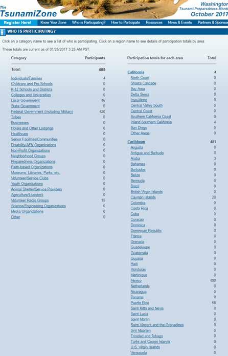
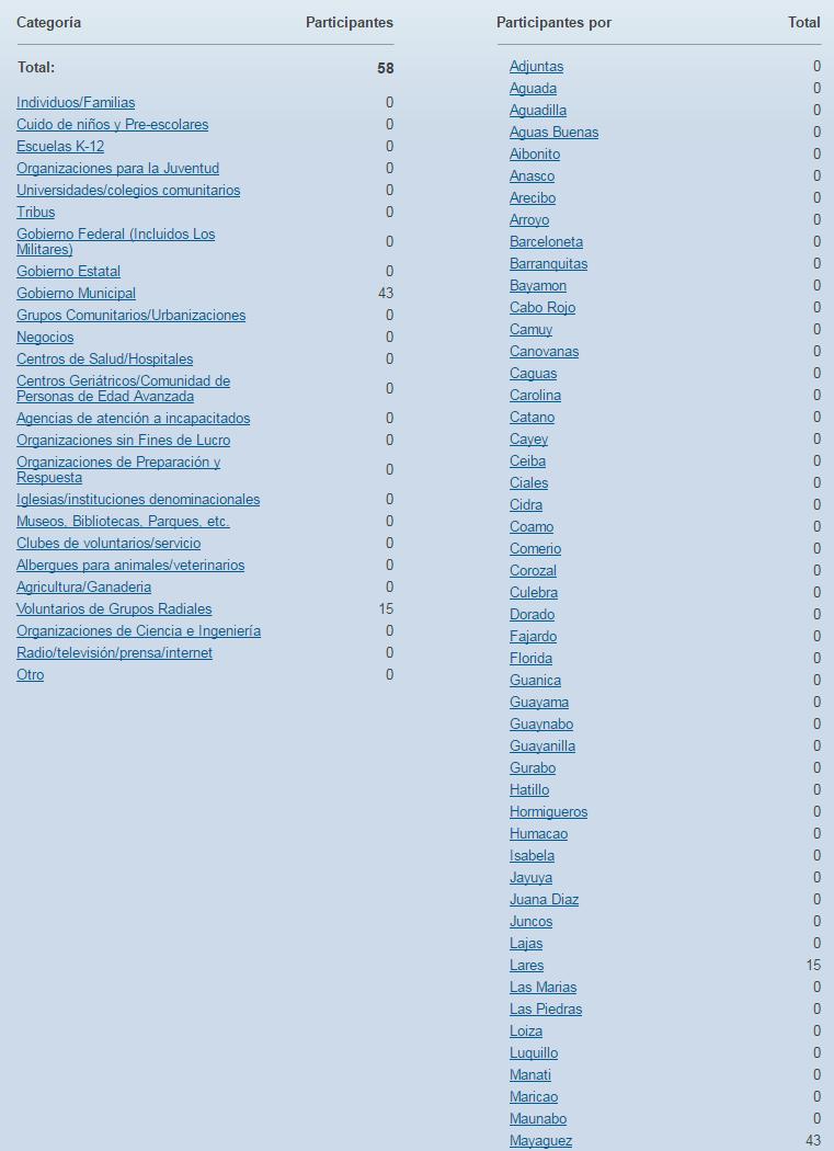
35
36 Media Arrangements PRSN Tsunami Media Guide (English and Spanish) Seismic Research Unit Tsunami and other Coastal Hazards WS Media Information Kit Handbook sample press release, which can be adapted as necessary. Social media; #CaribeWave
37 Actions in Case of a Real Event In the case of a real event occurring during the exercise, the PTWC will issue the corresponding messages for the event. Such messages will be given full priority and a decision will be made by the PTWC whether to issue the Caribe Wave 17 dummy messages and to send messages to corresponding recipients. In the case of smaller earthquakes, PTWC will issue the corresponding Tsunami Information Statement and the exercise will not be disrupted. All documentation and correspondence relating to this exercise is to be clearly identified as CARIBE WAVE 17 and Exercise.
38 Procedure for False Alarm Any time disaster response exercises are conducted; the potential exists for the public or media to interpret the event as real. Procedures should be set up by all participating entities to address public or media concerns involving this exercise in case of misinterpretation by media or the public.
39 Resources IOC Manual How to plan, conduct and evaluate tsunami exercises which will also be a useful resource. CARIBE WAVE 2011, 2013, 2014, 2015, 2016 Handbooks CARIBE WAVE 2013, 2014, 2015, 2016 Final and Media Report PTWC Communications Plan for the Caribbean Available at Questions on the exercise can be addressed to the members of the CARIBE WAVE 17 Task Team
40 Additional Info Additional materials will be added to CTWP ( and PRSN websites (prsn.uprm.edu). Over the next weeks PTWC will make available the simulated DOMESTIC products for the PR, USVI and BVI A similar presentation to this available on CTWP website Can make available this presentation to CRRT
41 CARIBE WAVE 17 Task Team Person Telephone # Patrick Tyburn, CARIBE WAVE 17 Chair, CARIBE EWS Chair WG patrick.tyburn@martinique.pref.gouv.fr Elizabeth Vanacore, PRSN, CARIBE WAVE past Chair elizabeth.vanacore@upr.edu Christa von Hillebrandt-Andrade, CARIBE EWS Chair; NWS CTWP Manager christa.vonh@noaa.gov Milton Puentes, CARIBE EWS Vice Chair milpuentes@gmail.com Gerard Metayer, CARIBE EWS Vice Chair gerard_metayer@yahoo.fr Paul Martens, CARIBE EWS Vice Chair Paul.Martens@sintmaartengov.org Jean Marie Saurel, CARIBE EWS WG1 Chair saurel@ipgp.fr Silvia Chacón, Chair CARIBE EWS WG silviachaconb@gmail.com Natalia Zamora, Scientific Expert - Costa Rica Scenario NA nzsauma@gmail.com Antonio Aguilar, CARIBE EWS WG3 Chair antoniodesastres@gmail.com Charles McCreery, PTWC Director charles.mccreery@noaa.gov Gerard Fryer, PTWC Rep gerard.fryer@noaa.gov Ronald Jackson, Director CDEMA ronald.jackson@cdema.org Roy Barboza Sequeira, Executive Secretary, CEPREDENAC rbarboza@sica.int Bernardo Aliaga, Technical Secretary UNESCO b.aliaga@unesco.org Valerie Clouard, Scientific Expert Northeastern Antilles Scenario clouard@ipgp.fr Bladimir Moreno, Scientific Expert Cuba Scenario bladimir@cenais.cu
42 Timeline ACTION Draft Circulated among ICG CARIBE EWS TNC/TWFP Deadline for Comments Final Exercise Handbook Available Online Circular Letter Issued by IOC to MS 1 st Webinar CW 2 nd Webinar CW Member States and Territories inform which scenario they will be using for the exercise Exercise Exercise Evaluation Due DUE DATE Sep-16 Sep-16 Oct-16 Nov Jan English 18 - Jan Spanish 19 - Jan French 7- Mar English 8- Mar Spanish 9- Mar French 10-Mar Mar-17 3-Apr-17 Draft Final Caribe 17 Report 19- Apr- 17 Discussion of Exercise ICG CARIBE EWS 12 th Session May-17
43 Questions, Comments Thank you
1 st Webinar. Christa G. von Hillebrandt-Andrade NOAA NWS Caribbean Tsunami Warning Program- Manager ICG CARIBE EWS Chair January 17, 2017
 17 1 st Webinar Christa G. von Hillebrandt-Andrade NOAA NWS Caribbean Tsunami Warning Program- Manager ICG CARIBE EWS Chair January 17, 2017 Institutional Reference Frame for the Exercise UNESCO: The United
CARIBE WAVE 16 Webinar English
 CARIBE WAVE 16 Webinar English Christa G. von Hillebrandt-Andrade NOAA NWS Caribbean Tsunami Warning Program- Manager ICG CARIBE EWS Chair January 19, 2016 Institutional Reference Frame for the Exercise
The Tsunami and Other Coastal Hazards Warning System for the Caribbean and Adjacent Regions (CARIBE EWS)
") The Tsunami and Other Coastal Hazards Warning System for the Caribbean and Adjacent Regions (CARIBE EWS) Christa von Hillebrandt-Andrade CARIBE EWS and US CTWP October 20, 2016 1. Objective Provide an
The Tsunami and Other Coastal Hazards Warning System for the Caribbean and Adjacent Regions (CARIBE EWS) Christa von Hillebrandt-Andrade CARIBE EWS and US CTWP October 20, 2016 1. Objective Provide an
FACTSHEET MAY Tsunami Warning and Mitigation Systems to protect Coastal Communities
 FACTSHEET MAY 2015 Tsunami Warning and Mitigation Systems to protect Coastal Communities Tsunami and other Costal Hazards Warning System for the Caribbean and Adjacent Regions (CARIBE-EWS) 2005 2015 BACKGROUND
CARIBBEAN TOURISM ORGANIZATION LATEST STATISTICS December 4, 2014
 CARIBBEAN TOURISM ORGANIZATION LATEST STATISTICS 2014 December 4, 2014 FINAL Destination Table 1: Tourist (Stop-over) Arrivals in 2014 Period Tourist Arrivals % Change Overall Winter# Summer# Anguilla
IOC Intergovernmental Coordination Group for the Tsunami and Other Coastal Hazards Warning System for the Caribbean and Adjacent Regions
 UNESCO IOC CTIC US NOAA ITIC Regional Training Workshop on Strengthening Tsunami Warning and Emergency Response Standard Operating Procedures and the Development of the ICG/CARIBE-EWS PTWC New Enhanced
CARIBBEAN TOURISM ORGANIZATION LATEST STATISTICS 2008
 CARIBBEAN TOURISM ORGANIZATION LATEST STATISTICS 2008 December 9, 2008 Table 1: Tourist (Stop-over) Arrivals in 2008 Period Tourist Arrivals % Change Overall Winter# Summer# Anguilla Jan-Aug 53,077-10.8-13.9-7.0
IMO/IHO World-Wide Navigational Warning Service NAVAREA IV / XII
 UNCLASSIFIED IMO/IHO World-Wide Navigational Warning Service NAVAREA IV / XII 10 December 2015 The World-Wide Navigational Warning Service (WWNWS) is the internationally and nationally coordinated service
Countries of the World
 As of September 2017 Countries of the World Website: Countries of the World. com https://www.countries-ofthe-world.com/countries-of-north-america.html Website: CIA.gov https://www.cia.gov/index.html Tales
Caribbean Tourism Organization
 Caribbean Tourism Organization 2017 year-to-date (Jan-Oct.) & Forward looking for next 6 months --- A focus on Travel Agencies Air reservation WTM - November 2017 SERVING MARKETS COVERED Retailers Financials
Puerto Rico and Virgin Islands Support Document, Timetable and Messages PRSN will issue for LANTEX 09
 Puerto Rico and Virgin Islands Support Document, Timetable and Messages PRSN will issue for LANTEX 09 A northwest-atlantic tsunami warning exercise: April 2, 2009 Puerto Rico Seismic Network Dept. of Geology
Published by the Caribbean Tourism Organization (CTO), All rights reserved.
, All rights reserved.") Copyright 2016, Caribbean Tourism Organization (CTO) Published by the Caribbean Tourism Organization (CTO), 2016. All rights reserved. The designations employed and the presentation of material in this
Copyright 2016, Caribbean Tourism Organization (CTO) Published by the Caribbean Tourism Organization (CTO), 2016. All rights reserved. The designations employed and the presentation of material in this
Carnival Glory (GL) Carnival Glory 7 Day Exotic Western Caribbean from Miami, FL Port Day Arrive Depart Port Notes
 Carnival Glory 7 Day Exotic Western Caribbean from Miami, FL Port Day Arrive Depart Port Notes") Carnival Glory (GL) Itineraries listed by Embarkation Home Port, in order of duration. Embarkation Home Port: Carnival Glory 7 Day Exotic Western Caribbean from Miami, FL Georgetown, Grand Cayman, Cayman
Carnival Glory (GL) Itineraries listed by Embarkation Home Port, in order of duration. Embarkation Home Port: Carnival Glory 7 Day Exotic Western Caribbean from Miami, FL Georgetown, Grand Cayman, Cayman
Researched and compiled by Ms. Elvira Doyle, UNDESA, 27 April 2004
 Status /Overseas THE CARIBBEAN COUNTRIES & REGIONAL ENTITIES United Nations Researched and compiled by Ms. Elvira Doyle, UNDESA, 27 April 2004 CARICOM a/ CARI FORUM b/ ECLAC/ CDCC c/ 1. Anguilla United
4.14 Tsunami Preparedness and Response TsunamiReady, Tsunami Smart, Hotel and Tourism
 UNESCO IOC CTIC US NOAA ITIC Regional Training Workshop on Strengthening Tsunami Warning and Emergency Response Standard Operating Procedures and the Development of the ICG/CARIBE-EWS PTWC New Enhanced
Appendix A. PHYSICAL, SOCIAL, AND ECONOMIC STATISTICS
 Appendix A. PHYSICAL, SOCIAL, AND ECONOMIC STATISTICS FOR THE CARIBBEAN REGION TABLE A1. CORAL REEF AREA IN THE WIDER CARIBBEAN Estimates of Coral Reef Area Reefs at Risk in the World Atlas of Coral Reefs
Eastern and Southern Caribbean Islands Eastern and Southern Caribbean Ports of Call Cruising the Caribbean Islands of New Discovery p.
 List of Maps p. xxxvii Eastern and Southern Caribbean Islands p. xxxvii Eastern and Southern Caribbean Ports of Call p. xxxviii Cruising the Caribbean Islands of New Discovery p. 1 How to Use This Guide
Carnival Breeze (BR)
") Carnival Breeze (BR) Itineraries listed in order of duration. Carnival Breeze 6 Day Exotic Eastern Caribbean from Port Canaveral, FL Nassau, The Bahamas 9:00am 5:00pm Amber Cove, Dominican Republic Wed
Carnival Breeze (BR) Itineraries listed in order of duration. Carnival Breeze 6 Day Exotic Eastern Caribbean from Port Canaveral, FL Nassau, The Bahamas 9:00am 5:00pm Amber Cove, Dominican Republic Wed
Published by the Caribbean Tourism Organization (CTO), All rights reserved.
, All rights reserved.") Copyright 2016, Caribbean Tourism Organization (CTO) Published by the Caribbean Tourism Organization (CTO), 2016. All rights reserved. The designations employed and the presentation of material in this
Copyright 2016, Caribbean Tourism Organization (CTO) Published by the Caribbean Tourism Organization (CTO), 2016. All rights reserved. The designations employed and the presentation of material in this
Puerto Rico Seismic Network Response Guide for Puerto Rico and the Virgin Islands Region LANTEX 12 EXERCISE
 Puerto Rico Seismic Network Response Guide for Puerto Rico and the Virgin Islands Region LANTEX 12 EXERCISE Tsunami Warning Exercise March 28 th, 2012 Puerto Rico Seismic Network Geology Department University
Carnival Pride (PR) Itineraries listed in order of duration. Carnival Pride 7 Day Florida and Bahamas from Baltimore, MD
 Itineraries listed in order of duration. Carnival Pride 7 Day Florida and Bahamas from Baltimore, MD") Carnival Pride (PR) Itineraries listed in order of duration. Carnival Pride 7 Day Florida and Bahamas from Baltimore, MD Staggered Check-In Time Window: 12:30pm 4:00pm Port Canaveral (Orlando), Florida
Carnival Pride (PR) Itineraries listed in order of duration. Carnival Pride 7 Day Florida and Bahamas from Baltimore, MD Staggered Check-In Time Window: 12:30pm 4:00pm Port Canaveral (Orlando), Florida
PBN Implementation CAR/NAM Regions
 Regional Forum Creating More Lift PBN Implementation CAR/NAM Regions Victor Hernandez RO ATM/SAR ICAO North America, Central America and Caribbean Regional Office Project: PBN Implementation Regional Performance
Exercise CARIBE WAVE 11/ LANTEX11 Participant Handbook
 Exercise CARIBE WAVE 11/ LANTEX11 Participant Handbook A Caribbean Tsunami Warning Exercise March 23, 2011 UNESCO IOC Intergovernmental Coordination Group for the Tsunami and other Coastal Hazards Warning
EXERCISE CARIBE WAVE 17 A Caribbean and Adjacent Regions Tsunami Warning Exercise 21 March 2017 (Costa Rica, Cuba and Northeastern Antilles Scenarios)
") Intergovernmental Oceanographic Commission technical series 133 EXERCISE CARIBE WAVE 17 A Caribbean and Adjacent Regions Tsunami Warning Exercise 21 March 2017 (Costa Rica, Cuba and Northeastern Antilles
Intergovernmental Oceanographic Commission technical series 133 EXERCISE CARIBE WAVE 17 A Caribbean and Adjacent Regions Tsunami Warning Exercise 21 March 2017 (Costa Rica, Cuba and Northeastern Antilles
University of Waikato Library: Map Collection
 The Map Collection of the University of Waikato Library contains a comprehensive collection of maps from around the world with detailed coverage of New Zealand and the Pacific. The maps are held in drawer
PRESENTATION ASSET RECOVERY INTER-AGENCY NETWORK FOR THE CARIBBEAN (ARIN-CARIB)
") Secretariat for Multidimensional Security XLIV MEETING OF THE GROUP OF EXPERTS FOR THE CONTROL OF MONEY LAUNDERING September 25-26, 2017 Asuncion, Paraguay OEA/Ser.L/XIV. 4.44 DDOT/LAVEX/doc.16/17 September
Secretariat for Multidimensional Security XLIV MEETING OF THE GROUP OF EXPERTS FOR THE CONTROL OF MONEY LAUNDERING September 25-26, 2017 Asuncion, Paraguay OEA/Ser.L/XIV. 4.44 DDOT/LAVEX/doc.16/17 September
ANI/WG/2 WP/11 22/05/15 Second NAM/CAR Air Navigation Implementation Working Group Meeting (ANI/WG/2) Puntarenas, Costa Rica, 1 to 4 June 2015
 Puntarenas, Costa Rica, 1 to 4 June 2015") ANI/WG/2 WP/11 22/05/15 Second NAM/CAR Air Navigation Implementation Working Group Meeting (ANI/WG/2) Puntarenas, Costa Rica, 1 to 4 June 2015 Agenda Item 4 Follow-up on the NAM/CAR Regional Performance
ANI/WG/2 WP/11 22/05/15 Second NAM/CAR Air Navigation Implementation Working Group Meeting (ANI/WG/2) Puntarenas, Costa Rica, 1 to 4 June 2015 Agenda Item 4 Follow-up on the NAM/CAR Regional Performance
TOURIST ARRIVALS REPORT
 No. of Arrivals TOURIST ARRIVALS REPORT Stay Over Arrivals by Market (June, 217) 18, 16, 14, 12, 1, 8, 6, 4, 2, USA UK Caribbean Canada Rest of Europe Germany France Rest of World 216 15,24 3,941 4,425
TOURIST ARRIVALS REPORT
 No. of Arrivals TOURIST ARRIVALS REPORT Stay Over Arrivals by Market (March, 217) 18, 16, 14, 12, 1, 8, 6, 4, 2, USA UK Caribbean Canada Rest of Europe Germany France Rest of World 216 15,61 6,61 5,57
Regional Governance related to the Marine Environment in the Wider Caribbean
 Regional Governance related to the Marine Environment in the Wider Caribbean Alessandra Vanzella-Khouri Caribbean Environment Programme (CEP) UNEP Kingston, Jamaica Caribbean Environment Programme (CEP)
Paper for the Consideration by CBSC18. MACHC report
 CBSC16-05.1I 16 th MEETING OF THE IHO CAPACITY BUILDING SUB-COMMITTEE IHO-CBSC16 Goa, India, 30 May - 1 June 2018 Submitted by: Executive Summary: Paper for the Consideration by CBSC18 MACHC report MACHC
For authorization of the reproduction of CTO works, please contact the CTO at the address and above.
 Copyright 2018, Caribbean Tourism Organization (CTO) Published by the Caribbean Tourism Organization (CTO), 2018. All rights reserved. The designations employed and the presentation of material in this
Annual Report of Implementation 2017 Citizens summary
 Annual Report of Implementation 2017 Citizens summary What is INTERREG Caraïbes? An European programme to promote cooperation in the Caribbean. INTERREG Caraïbes provides financial support for projects
TOURIST ARRIVALS REPORT
 No. of Arrivals TOURIST ARRIVALS REPORT Stay Over Arrivals by Market (, 217) 16, 14, 12, 1, 8, 6, 4, 2, USA UK Caribbean Canada Rest of Europe Germany France Rest of World 216 13,454 5,969 4,154 5,881
TOURIST ARRIVALS REPORT
 No. of Arrivals TOURIST ARRIVALS REPORT Stay Over Arrivals by Market (May 2016) 16,000 14,000 12,000 10,000 8,000 6,000 4,000 2,000 0 USA UK Caribbean Canada Rest of Europe Germany France Rest of World
World Tourism Organization Leading organization in the field of tourism today. Global forum for tourism policy issues and a practical source of
 World Tourism Organization Leading organization in the field of tourism today. Global forum for tourism policy issues and a practical source of tourism know how Members are 139 countries and 350 affiliate
CARIBBEAN ISLANDS 260,671 km 2
 The Bahamas Havana Cuba Camaguey Santiago de Cuba Dominican Republic Santiago Port-au-Prince San Juan Mexico Jamaica Kingston Haiti Santo Domingo Puerto Rico Venezuela CARIBBEAN ISLANDS 260,671 km 2 BIODIVERSITY
VISITOR ARRIVALS REPORT
 No. of Arrivals VISITOR ARRIVALS REPORT Stay Over Arrivals by Market (September, 217) 9, 8, 7, 6, 5, 4, 3, 2, 1, USA UK Caribbean Canada Rest of Europe Germany France 216 7,91 3,874 4,36 1,134 374 6 114
Climate Change and Tourism A Caribbean Tourism Organization Perspective
 Climate Change and Tourism A Caribbean Tourism Organization Perspective Presented by: Gail N. Henry Sustainable Tourism Product Specialist Caribbean Tourism Organization CARIBSAVE Partners Symposium, The
URBAN!ZATION AND URBAN GROWTH IN THE CARIBBEAN. by Malcolm Cross Cambridge University Press. 1979
 REviEW ARTICLE OF: URBAN!ZATION AND URBAN GROWTH IN THE CARIBBEAN by Malcolm Cross Cambridge University Press. 1979 For any student of Caribbean affairs the title of Malcolm Cross's book is one to whet
TOURIST ARRIVALS REPORT
 No. of Arrivals TOURIST ARRIVALS REPORT Stay Over Arrivals by Market (February 2016) 16,000 14,000 12,000 10,000 8,000 6,000 4,000 2,000 0 USA UK Caribbean Canada Rest of Europe Germany France Rest of
AVIATION SECURITY (AVSEC) AND FACILITATION (FAL) TRAINING AND ASSISTANCE ACTIVITIES IN THE NAM/CAR REGIONS. (Presented by the Secretariat)
 AND FACILITATION (FAL) TRAINING AND ASSISTANCE ACTIVITIES IN THE NAM/CAR REGIONS. (Presented by the Secretariat)") 26/11/14 Second NAM/CAR Civil Aviation Training Centres Working Group Meeting (NAM/CAR/CATC/WG/2) ICAO NACC Regional Office, Mexico City, Mexico, 2 to 5 December 2014 Agenda Item 9: Other Business AVIATION
26/11/14 Second NAM/CAR Civil Aviation Training Centres Working Group Meeting (NAM/CAR/CATC/WG/2) ICAO NACC Regional Office, Mexico City, Mexico, 2 to 5 December 2014 Agenda Item 9: Other Business AVIATION
Cartagena, Colombia August 2013 Dav Ernan Kowlessar
 Cartagena, Colombia August 2013 Dav Ernan Kowlessar Context of this presentation CAIC Overview Reality of the Caribbean Landscape Input from the Caribbean Private Sector on developing a Roadmap Management
DEVELOPMENT AID AT A GLANCE
 DEVELOPMENT AID AT A GLANCE STATISTICS BY REGION 3. AMERICA 2018 edition All the data in this report are available at: http://www.oecd.org/dac/financing-sustainable-development/ 3.1. ODA TO AMERICA - SUMMARY
Alessandra Vanzella-Khouri, SPAW Secretariat Helene Souan, Director, SPAW-RAC
 UNEP s Caribbean Environment Programme (CEP) The Specially Protected Areas and Wildlife Protocol (SPAW) and the Regional Activity Centre for SPAW Protocol (SPAW RAC) Alessandra Vanzella-Khouri, SPAW Protocol
WÄRTSILÄ IN CENTRAL AMERICA AND THE CARIBBEAN
 WÄRTSILÄ IN CENTRAL AMERICA AND THE CARIBBEAN Harri Antikainen Financial Analyst, Project Development Wärtsilä Energy Solutions March 2018 WÄRTSILÄ HAS STRONG PRESENCE IN THE REGION Wärtsilä has a decades
Aviation Security (AVSEC) and Facilitation (FAL) 7.3 Other Aviation Security and Facilitation Matters
 and Facilitation (FAL) 7.3 Other Aviation Security and Facilitation Matters") 09/04/14 Fifth North American, Central American and Caribbean Directors of Civil Aviation Meeting (NACC/DCA/5) Port-of-Spain, Trinidad and Tobago, 28 to 30 April 2014 Agenda Item 7: Aviation Security (AVSEC)
09/04/14 Fifth North American, Central American and Caribbean Directors of Civil Aviation Meeting (NACC/DCA/5) Port-of-Spain, Trinidad and Tobago, 28 to 30 April 2014 Agenda Item 7: Aviation Security (AVSEC)
United Nations Environment Programme
 UNITED NATIONS EP United Nations Environment Programme Distr. RESTRICTED UNEP(DEPI)/CAR IG.28/INF.9 1 July 2008 Original: ENGLISH Thirteenth Intergovernmental Meeting on the Action Plan for the Caribbean
SAILING SCHEDULE SOUTH FLORIDA SERVICE
 ABC VENEZUELA SERVICE Aruba, Curacao, Bonaire, La Guaira, Puerto Cabello. Maracaibo Frequency: Weekly Sailings Departs Everglades every Saturday / Northbound Vessel FS IPANEMA MELBOURNE STRAIT FS IPANEMA
CARIBBEAN TOURISM STATISTICAL REPORT Edition
 CARIBBEAN TOURISM STATISTICAL REPORT 2016 Edition CARIBBEAN TOURISM ORGANIZATION Seventh Floor, Baobab Tower Warrens, St Michael, BB22026 Barbados Tel.: (246) 427-5242 Website: www.onecaribbean.org E-mail:
Caribbean Tourism Review
 Thousands PERCENTAGE Caribbean Tourism Review 1. Global Performance Worldwide international arrivals in the first eight months reached 781 million, 36 million more than in the same period of 2013 according
ASSEMBLY 39TH SESSION
 International Civil Aviation Organization WORKING PAPER 1/9/16 6/9/16 ASSEMBLY 39TH SESSION TECHNICAL COMMISSION Agenda Item 33: Aviation safety and air navigation monitoring and analysis COMPLIANCE WITH
SAILING SCHEDULE SOUTH FLORIDA SERVICE
 ABC VENEZUELA SERVICE Aruba, Curacao, Bonaire, La Guaira, Puerto Cabello. Maracaibo Frequency: Weekly Sailings Departs Everglades every Saturday / Northbound Vessel FS IPANEMA MELBOURNE STRAIT FS IPANEMA
The Association of Caribbean States (ACS).
.") 1. Objectives The Association of Caribbean States (ACS). Coordination and Cooperation towards urban seismic risk reduction in the Greater Caribbean Region. Arturo López- Por.llo Contreras. Director of
1. Objectives The Association of Caribbean States (ACS). Coordination and Cooperation towards urban seismic risk reduction in the Greater Caribbean Region. Arturo López- Por.llo Contreras. Director of
Secondary Education FAIE Annual State Conference Kurt Baumbach, Academic Evaluation Services, Inc. Caribbean Countries
 Secondary Education 2018 FAIE Annual State Conference Kurt Baumbach, Academic Evaluation Services, Inc. Caribbean Countries Secondary Education - Caribbean Countries Secondary Education - Caribbean Countries
Exercise CARIBE WAVE/ LANTEX13 Participant Handbook
 Exercise CARIBE WAVE/ LANTEX13 Participant Handbook A Caribbean Tsunami Warning Exercise March 20, 2013 UNESCO IOC Intergovernmental Coordination Group for the Tsunami and other Coastal Hazards Warning
SAILING SCHEDULE SOUTH FLORIDA SERVICE
 ABC VENEZUELA SERVICE Aruba, Curacao, Bonaire, La Guaira, Puerto Cabello. Maracaibo Frequency: Weekly Sailings Departs Jacksonville every Wednesday and Everglades every Saturday / Northbound Vessel FS
Upcoming Adventures
 www.singlescruise.com 800.393.5000 April 2018 8 Night Panama Canal Apr 14-22, 2018 Carnival Miracle Ports: Tampa, FL Limón, Costa Rica Panama Canal Partial Transit Grand Cayman, Grand Cayman Islands May
Contact Agent: John Doe
 April 2018 8 Night Panama Canal Apr 14-22, 2018 Carnival Miracle Ports: Tampa, FL Limón, Costa Rica Panama Canal Partial Transit Grand Cayman, Grand Cayman Islands May 2018 7 Night Hawaii (LAND Based)
DEVELOPMENT AID AT A GLANCE
 DEVELOPMENT AID AT A GLANCE STATISTICS BY REGION 3. AMERICA 26 edition 3.. ODA TO AMERICA - SUMMARY 3... Top ODA receipts by recipient USD million, net disbursements in 24 3..3. Trends in ODA Colombia
TABLE 1 VISITOR ARRIVALS. Total Visitor Arrivals +/ Month / / /18
 TABLE 1 VISITOR ARRIVALS Stopover Arrivals +/ Cruise Passengers +/ Total Visitor Arrivals +/ Month 2018 2019 2019/18 2018 2019 2019/18 2018 2019 2019/18 January 194,609 216,509 11.3% 249,635 249,239 0.2%
Christa VON HILLEBRANDT-ANDRADE Chair Working Group 1 ICG/CARIBE EWS: Monitoring and Detection Systems, Warning Guidance
 UPDATE ON SEA LEVEL NETWORK DEVELOPMENTS OF THE INTERGOVERNMENTAL COORDINATION GROUP FOR THE TSUNAMI AND OTHER COASTAL HAZARDS FOR THE CARIBBEAN AND ADJACENT REGIONS (ICG/CARIBE EWS) Christa VON HILLEBRANDT-ANDRADE
18th MEETING OF THE MESO AMERICAN AND CARIBBEAN SEA HYDROGRAPHIC COMMISSION (MACHC18) 27 November 2 December 2017, Varadero, Cuba
 27 November 2 December 2017, Varadero, Cuba") 18th MEETING OF THE MESO AMERICAN AND CARIBBEAN SEA HYDROGRAPHIC COMMISSION (MACHC18) 27 vember 2 December 2017, Varadero, Cuba Logistics Information The 18 th Meeting of the Mesoamerican-Caribbean Sea
18th MEETING OF THE MESO AMERICAN AND CARIBBEAN SEA HYDROGRAPHIC COMMISSION (MACHC18) 27 vember 2 December 2017, Varadero, Cuba Logistics Information The 18 th Meeting of the Mesoamerican-Caribbean Sea
LatinAmericaand the Caribbean
 International ComparisonProgram(ICP) LatinAmericaand the Caribbean Giovanni Savio EC Statistics Division losure Authorized Public Disclosure Authorized Public Disclosure Authorized Public Disclosure Authorized
Population, Territory and Sustainable Development The Case of the Caribbean Sub Region
 Population, Territory and Sustainable Development The Case of the Caribbean Sub Region Author: Godfrey St. Bernard Sir Arthur Lewis Institute of Social and Economic Studies The University of the West Indies
UN-GGIM:Americas. UN-GGIM Expanded Bureau Meeting 7-9 December 2016, UN Headquarters New York. Rolando Ocampo President of UN-GGIM:Americas
 UN-GGIM:Americas UN-GGIM Expanded Bureau Meeting 7-9 December 2016, UN Headquarters New York Rolando Ocampo President of UN-GGIM:Americas Antigua and Barbuda 38 Member States Argentina Bahamas Belize Bolivia
Airline Capacity in the Caribbean. Michael Lum Air Service Strategy and Development Consultant Sixel Consulting Group, Inc.
 Airline Capacity in the Caribbean Michael Lum Air Service Strategy and Development Consultant Sixel Consulting Group, Inc. October 2013 2 Today's Discussion How has airline capacity in the Caribbean changed
The Final Act of the Conference of Plenipotentiaries Concerning Specially Protected Areas and Wildlife in the Wider Caribbean Region
 The Final Act of the Conference of Plenipotentiaries Concerning Specially Protected Areas and Wildlife in the Wider Caribbean Region Kingston, Jamaica, 15-18 January 1990 1. The Conference of Plenipotentiaries
REGION B B. 1 MESO-AMERICA AND CARIBBEAN SEA MESO-AMERIQUE ET MER CARAÏBES. Coordonnateur : USA (National Ocean Service)
") Catalogue of International Charts B. 1 PART B PARTIE B REGION B MESO-AMERICA AND CARIBBEAN SEA Coordinator : USA (National Ocean Service) MESO-AMERIQUE ET MER CARAÏBES Coordonnateur : USA (National Ocean
Catalogue of International Charts B. 1 PART B PARTIE B REGION B MESO-AMERICA AND CARIBBEAN SEA Coordinator : USA (National Ocean Service) MESO-AMERIQUE ET MER CARAÏBES Coordonnateur : USA (National Ocean
Preventing disease Promoting and protecting health
 Preventing disease Promoting and protecting health CARPHA A New Caribbean Public Health Agency: Responding to public health emergencies Dr Babatunde Olowokure Director Surveillance, Disease Prevention
1. Introduction. 2. Basic Fundamentals. 4. Results. 5. Initiatives. 6. Final Conclusions.
 1 1. Introduction. 2. Basic Fundamentals. 3. Small member states of the OAS, CARICOM and IAD 4. Results. 5. Initiatives. 6. Final Conclusions. 2 THE IADB IS MANDATED BY STATUTE TO ADDRESS THE NEEDS OF
For authorization of the reproduction of CTO works, please contact the CTO at the address and above.
 Copyright 2018, Caribbean Tourism Organization (CTO) Published by the Caribbean Tourism Organization (CTO), 2018. All rights reserved. The designations employed and the presentation of material in this
CARIBBEAN TOURISM CLIMATIC BULLETIN
 A Joint Bulletin of the CTO, the CHTA and the CIMH CARIBBEAN TOURISM CLIMATIC BULLETIN for Tourism Businesses and Policymakers March-April-May 2019 I Vol 3 I Issue 1 Photo Credit: Anguilla Tourist Board
COMMERCIAL ROUTES BETWEEN DOMINICAN REPUBLIC AND THE CARIBBEAN
 COMMERCIAL ROUTES BETWEEN DOMINICAN REPUBLIC AND THE CARIBBEAN 1 National Council of Competitiveness General Direction Rafael Paz Technical Direction Laura Del Castillo Editorial Coordination Sol Disla
OPERATIONAL MOVEMENTS
 By Sam185 OPERATIONAL MOVEMENTS CONTENTS 1964 Page 2 1965 Page 3 1966 Page 6 1967 Page 7 1968 Page 8 Sam185 2012 Page 1 The information contained in the following pages of Operational Movements of HMS
ICELANDAIR NICE-REYKJAVIK SURVEY. OPPORTUNITIES SURVEY SOUTH & CENTRAL AMERICA / CARRIBEAN FROM/TO NICE AIRPORT Routes Online 2012
 ICELANDAIR NICE-REYKJAVIK SURVEY OPPORTUNITIES SURVEY SOUTH & CENTRAL AMERICA / CARRIBEAN FROM/TO NICE AIRPORT Routes Online 2012 1 NICESOUTH & CENTR.AM / CARRIBEAN 2 - South & Central Amer. / Carribean
2011 LESSER ANTILLES, CENTRAL AMERICA & CUBA Cruise N Date from/to Nights
 LSSR ANTILLS, CNTRAL AMRICA & CUBA CARIBBAN GOLF CUP 2011 SCII-1101 January 3 to 14, 2011 St. John s (Antigua) to Bridgetown (Barbados) 11 SCII-1111 March 28 to April 8, 2011 St. John s (Antigua) to Bridgetown
FUTURE FOR DOMINICAN REPUBLIC AS LNG HUB IN THE CARIBBEAN
 FUTURE FOR DOMINICAN REPUBLIC AS LNG HUB IN THE CARIBBEAN LNG gc AMERICAS June 2 nd 2017 Houston, Texas by Fernando Gonzalez 1 AGENDA 1./ DOMINICAN REPUBLIC A SUITABLE GEOGRAPHICAL POSITION 2./ DRIVERS
ITU is the United Nations specialized agency for information and communications technologies - ICTs
 THE WORLD AMERICAS ITU is the United Nations specialized agency for information and communications technologies - ICTs 192 Member States and over 700 private-sector entities and academic institutions 3
Day 1 - Wednesday, January 10: Miami, Florida? Marsh Harbour, Bahamas (190nm)
") Day 1 - Wednesday, January 10: Miami, Florida? Marsh Harbour, Bahamas (190nm) Fly to Marsh Harbour. Upon arrival, transfer to Hopetown Inn & Marina. Hotel : Hopetown Inn & Marina Day 2 - Thursday, January
Day 1 - Wednesday, January 10: Miami, Florida? Marsh Harbour, Bahamas (190nm) Fly to Marsh Harbour. Upon arrival, transfer to Hopetown Inn & Marina. Hotel : Hopetown Inn & Marina Day 2 - Thursday, January
For authorization of the reproduction of CTO works, please contact the CTO at the address and above.
 Copyright 2018, Caribbean Tourism Organization (CTO) Published by the Caribbean Tourism Organization (CTO), 2018. All rights reserved. The designations employed and the presentation of material in this
GENERAL INFORMATION. (Presented by the Secretariat)
") International Civil Aviation Organization 21/06/05 North American, Central American and Caribbean Office Second Meeting of North American, Central American and Caribbean Directors of Civil Aviation (NACC/DCA/2)
International Civil Aviation Organization 21/06/05 North American, Central American and Caribbean Office Second Meeting of North American, Central American and Caribbean Directors of Civil Aviation (NACC/DCA/2)
Population, Territory and Sustainable Development in the Caribbean
 Population, Territory and Sustainable Development in the Caribbean Author: Godfrey St. Bernard Sir Arthur Lewis Institute of Social and Economic Studies The University of the West Indies St. Augustine,
Fieldwork Dates AmericasBarometer
 Fieldwork Dates AmericasBarometer 2004-2014 This document contains information regarding fieldwork s for the AmericasBarometer project, 2004-2014. Some information may be incomplete and we will up the
COUNTRY & TERRITORY PROFILES A Summary of Oil Spill Response Arrangements & Resources Worldwide
 3. COUNTRY & TERRITORY PROFILES (including date of update) A Albania August 2010 Antigua January 2009 Algeria May 2011 Argentina December 2015 Angola May 2009 Aruba April 2008 Anguilla November 2005 Australia
SAILING SCHEDULE SOUTH FLORIDA SERVICE
 ABC VENEZUELA SERVICE Aruba, Curacao, Bonaire, La Guaira, Puerto Cabello. (Direct Service) Frequency: Weekly Sailings Departs Jacksonville every Wednesday and Everglades every Saturday / Northbound Vessel
CariCOF Drought Outlook. By the end of March 2019
 CariCOF Drought Outlook By the end of March 2019 Shorter term Drought Outlook (October 2018 to March 2019) Areas under immediate drought concern? Current Outlook Current update (December 2018): We are
Climate Change Impacts and Adaptation for Coastal Transport Infrastructure in Caribbean SIDS
 UNCTAD National Workshop Jamaica 30 May 1 June 2017, Kingston, Jamaica Climate Change Impacts and Adaptation for Coastal Transport Infrastructure in Caribbean SIDS The Convention for the Protection and
Logistics in the Caribbean
 Logistics in the Caribbean Current Trends and Future Prospects Caribbean Growth Forum June 19 th, 2012 Kingston, Jamaica Jordan Schwartz Gözde Isik World Bank Productivity losses (%) 30 25 20 15 10 5 OECD
TOURIST CRUISE SHIPS AND THE TRADE IN SERVICES: RECENT TRENDS IN COUNTRIES OF THE CARIBBEAN BASIN
 Issue No. 223, March 2005 TOURIST CRUISE SHIPS AND THE TRADE IN SERVICES: RECENT TRENDS IN COUNTRIES OF THE CARIBBEAN BASIN This issue of the Bulletin reviews the main trends of trade in goods and services
STAR CLIPPERS Tall Ship Cruises That Dreams Are Made Of 2017/18 Winter Preview
 www.starclipperscruises.co.uk STAR CLIPPERS Tall Ship Cruises That Dreams Are Made Of Early Booking Discounts up to 20% available for all bookings before 30th April 2017 * 2017/18 Winter Preview Thailand
REGIONAL APPROACHES TO DISASTER RECOVERY AND HERITAGE PRESERVATION BY RITA TJIEN FOOH
 REGIONAL APPROACHES TO DISASTER RECOVERY AND HERITAGE PRESERVATION BY RITA TJIEN FOOH BRITISH VIRGIN ISLAND SINT MAARTEN (DUTCH) SAINT MARTIN SAINT MARTIN CARBICA OUTREACH TO MEMBERS AFTER THE HURRICANES
Caribbean Youth Policy Review
 Caribbean Youth Policy Review Presentation to the Caribbean Forum on Population, Youth and Development July 24, 2018 Caribbean youth policy review Key findings Context Methodology Participating countries
Latin America and the Caribbean: Fact Sheet on Economic and Social Indicators
 Latin America and the Caribbean: Fact Sheet on Economic and Social Indicators Dindi R. Robinson Barbara Salazar Torreon May 30, 2013 CRS Report for Congress Prepared for Members and Committees of Congress
GROUPINGS / FIXTURES
 GROUP 1 ANTIGUA& BARBUDA ARUBA - ST. KITTS & NEVIS March 23 1 Antigua & Barbuda Aruba Sir Vivian Richards Cricket 7:30PM 2-1 March 26 2 Aruba St. Kitts & Nevis Centro Deportivo Guillermo Trinidad 8:00PM
TOURIST (Stopover Arrivals) Europe. United States. Canada. Latin America. Monthly Statistical Report
 Europe. United States. Canada. Latin America. Monthly Statistical Report") J 2017 V XXV, I 1 Monthly Statistical Report IN 2017 Stopover arrivals up 3.5% US Market up 1.9% Canada up 6.3% Europe up 7.8% Cruise Passenger up by 10.2% TOURIST (Stopover Arrivals) Stopover arrivals
J 2017 V XXV, I 1 Monthly Statistical Report IN 2017 Stopover arrivals up 3.5% US Market up 1.9% Canada up 6.3% Europe up 7.8% Cruise Passenger up by 10.2% TOURIST (Stopover Arrivals) Stopover arrivals
TECHNICAL SEMINAR ON TOURISM INVESTMENTS IN THE AMERICAS Asuncion, Paraguay. May 17-18, 2011
 TECHNICAL SEMINAR ON TOURISM INVESTMENTS IN THE AMERICAS Asuncion, Paraguay May 17-18, 2011 STRUCTURE OF PRESENTATION CONTEXT TOURISM IN THE AMERICAS ROLES OF INSTITUTIONS FOCUS ON OAS AS A MULTILATERAL
1 of 7 10/4/2010 5:16 PM
 1 of 7 10/4/2010 5:16 PM Home About Contact Boat Drinks Island Webcams Islands Greater Antilles Cuba Dominican Republic Jamaica Puerto Rico Key West & Florida Keys Leeward Islands Anguilla Antigua British
Caribbean EVDO & CDMA Roaming Market: Potential Revenue:
 Caribbean EVDO & CDMA Roaming Market: Potential Revenue: 2005 2010 Jose F. Otero Signals Telecom Consulting CDMA Roaming Forum Rio de Janeiro, Brazil April 18, 2005 Prepared for: About Signals Founded
Luis Ajamil President and CEO Bermello Ajamil & Partners, Inc.
 Luis Ajamil President and CEO Bermello Ajamil & Partners, Inc. October 2014 CRUISE SHIPS IN MICRONESIA CHALLENGES AND OPPORTUNITIES LUIS AJAMIL BERMELLO, AJAMIL & PARTNERS OCTOBER 2014 Cruise experience