Toronto and East York Community Council. Director, Community Planning, Toronto and East York District
|
|
|
- Eugenia Lambert
- 6 years ago
- Views:
Transcription

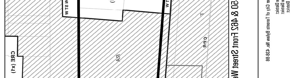
1 STAFF REPORT ACTION REQUIRED 440, 444, 450 and 462 Front Street; 425, 439, 441 and 443 Wellington Street West; 6-18 Spadina Avenue and 1 and 19 Draper Street - Zoning and Official Plan Amendment Application - Preliminary Report Date: May 2, 2014 To: From: Wards: Reference Number: Toronto and East York Community Council Director, Community Planning, Toronto and East York District Ward 20 Trinity-Spadina STE 20 OZ SUMMARY This application proposes to amend the City of Toronto Official Plan (King-Spadina Secondary Plan), the former City of Toronto Zoning By-law and comprehensive Zoning By-law No to permit a comprehensive development that includes seven mixed-use buildings. The tallest building is a 34-storey office tower at the north-west corner of Spadina Avenue and Front Street West. Three buildings on Front Street West step down in height to Draper Street to the west and have heights of 40-storeys, 34-storeys and 19-storeys. The proposed buildings fronting on Wellington Street West also step down in height from Spadina Avenue to Draper Street and are proposed at 17-storeys, 16- storeys and 14-storeys. All seven building will house at least two uses, with some buildings along Front Street West housing all three uses. The proposal also includes 1
2 open space with pedestrian connections and linear parks adjacent Wellington Street and Draper Street. All parking and loading will be provided underground. This report provides preliminary information on the above-noted application and seeks Community Council's directions on further processing of the application and on the community consultation process. Staff will be assessing the appropriate height and massing of the proposed buildings in the context of the objectives of the King-Spadina Secondary Plan and the Official Plan. Staff will also review the need for appropriate open space connections through the site along with community improvements such as a possible on-site parkland dedication and off site parkland improvements. Further processing of the application and public consultation process are recommended in order to give the applicant the opportunity to work with City staff, the community and the Ward Councillor to address the applicable Official Plan objectives and other issues that may arise through further review of the application. RECOMMENDATIONS The City Planning Division recommends that: 1. Staff be directed to schedule a community consultation meeting for the lands at 440, 444, 450 and 462 Front Street; 425, 439, 441 and 443 Wellington Street West; 6-18 Spadina Avenue and 1 and 19 Draper Street, together with the Ward Councillor. 2. Notice for the community consultation meeting be given to landowners and residents within 120 metres of the site. 3. Notice for the public meeting under the Planning Act be given according to the regulations under the Planning Act. Financial Impact The recommendations in this report have no financial impact. DECISION HISTORY On February 8, 2012, an application for a minor variance (A0089/12TEY) was submitted for the property at 6-18 Spadina Avenue for a 19-storey office building at the north-west corner of Front Street and Spadina Avenue. The variance application as approved on May 16, 2012 provided for a variance to the building height from 39 metres for the south part of that property and 61 metres for the north portion of the property to metres (19-storeys including a mechanical penthouse). Variances were also granted to provide relief from By-law requirements for angular plane, side yard setbacks, maximum building 2
3 depth from a street, loading space requirements and minimum parking space dimensions for obstructed parking spaces. The variances were not opposed by City staff. On February 24, 2012 a Site Plan Control application was submitted for a19-storey office building with a total gross floor area of 37,263 sq. metres at 6-18 Spadina Avenue. The application was being processed when the owners of the property sold the lands to the current owners. On November 27, 2012 the applicant requested City Planning staff to place the application on hold until further notice. On November 20, 2013, the application was closed. The use of the now vacant parcel at 6-18 Spadina Ave. as a surface parking lot is in contravention of the requirements of the Zoning By-law , which prohibits the creation of new commercial parking lots in the King-Spadina Secondary Plan area. The City's Municipal Licensing and Standards Division has issued a notice of violation regarding the use of the property. Pre-Application Consultation The owners of the property have been discussing the proposed redevelopment of the former Globe and Mail lands with a number of City staff from various Divisions since late These meetings have been coordinated by Community Planning staff but have included staff from Urban Design, Transportation Planning, Heritage Preservation Services Engineering and Construction Services, Transportation Services, Fire Services and Parks, Forestry and Recreation. These meetings allowed staff to understand the scope of the project and the implications and opportunities presented by the proposed development prior to the submission of the application. These meetings were useful and have established a dialogue between the applicant and City staff. The applicant has also met with the Ward Councillor and the Wellington Place Neighbourhood Association to discuss the proposal and its relationship to the existing mid-rise neighbourhood to the north and west of the site. The applicant has indicated that the true mixed-use nature of the development and the partnership of three major companies with expertise and interests in the project add to the complexity of the redevelopment of the site both conceptually and in terms of how the development is phased and constructed. The means of approving the development and how planning approvals will be granted and phased is still under discussion. ISSUE BACKGROUND Proposal The proposed development consists of seven mixed-use buildings and associated underground parking. The development is being referred to as The Well by the consortium of developers who are collectively involved in the project. All of the 3
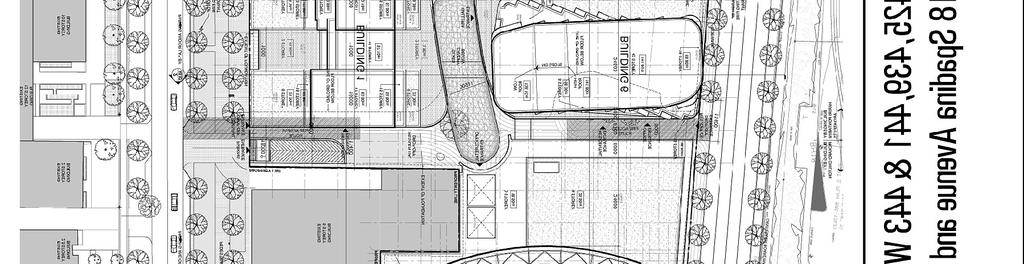
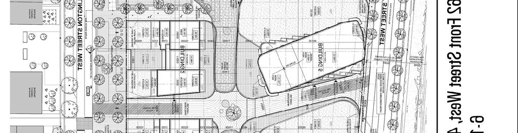
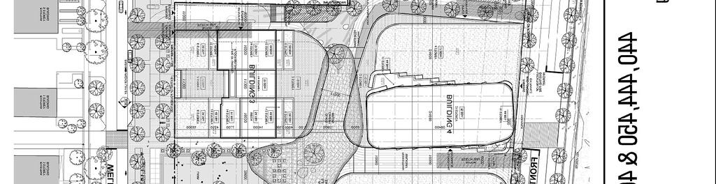
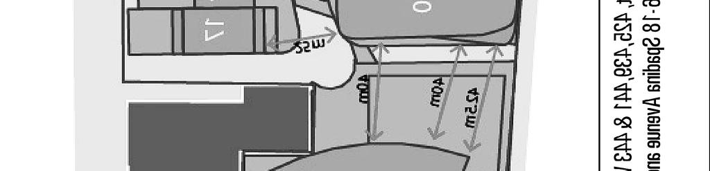
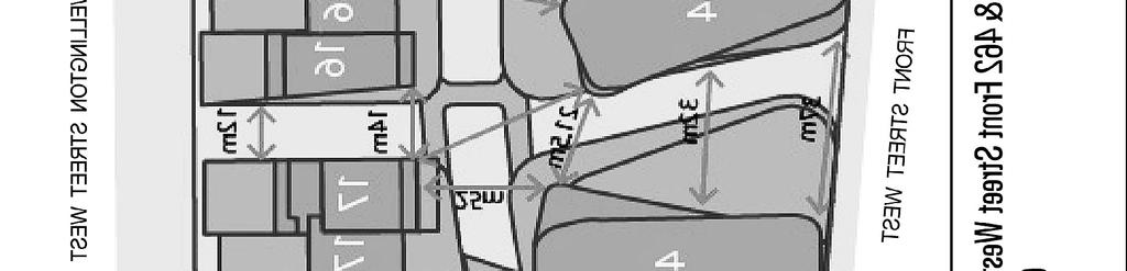
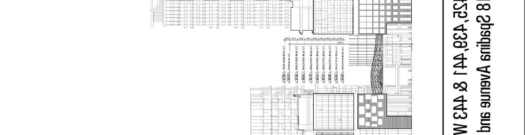
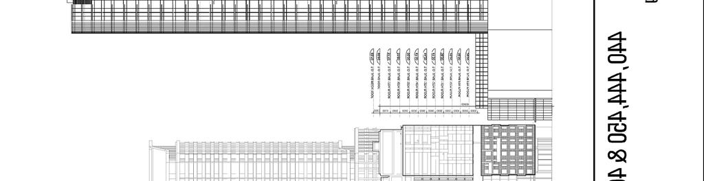
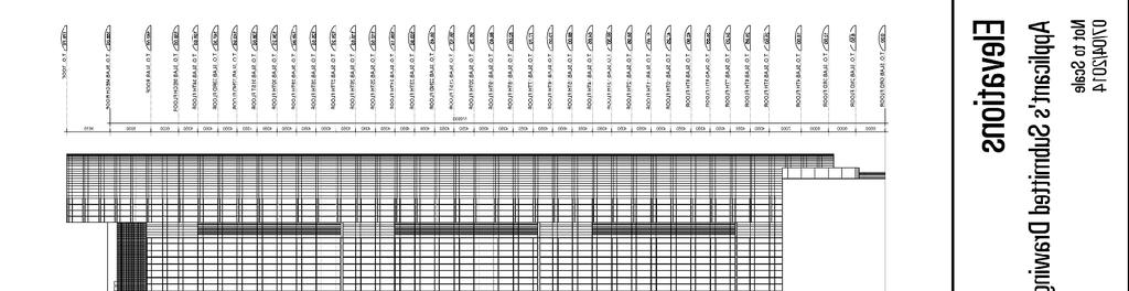
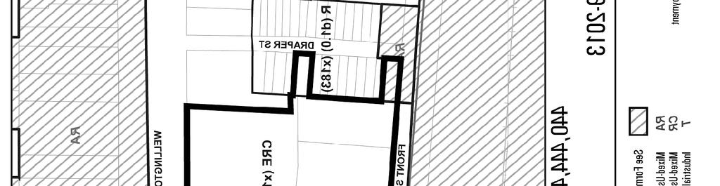
4 buildings on the site are proposed to include at least two of the three proposed uses for the site. All of the building on the site would include a base building and a taller building element. The retail component of the site would be included with the first two floors of all seven buildings proposed for the site. The first underground level would also include a lower concourse level which would include large-format retail uses as well as loading and bicycle parking. All of the buildings fronting on Front Street West would include an office component within the base building. All of the proposed buildings, except for the proposed office tower at the corner of Front Street and Spadina Ave. would include a residential component located in the taller portion of the buildings. Overall, the buildings have a combined gross floor area of 288, 225 square metres. Residential uses account for 137,043 square metres (47.5%), office uses account for 98,261 square metres (34.1%) and retail uses account for 52,922 square metres (18.4%). See Attachment 8 Application Data Sheet. The tallest of the buildings, a proposed 34-storey office tower (176.7 metres in height including mechanical elements) is proposed to be located at the north-west corner of Spadina Ave. and Front Street West. The building would include a three-storey retail base and would be immediately adjacent to the listed heritage building at the south-west corner of Wellington Street West and Spadina Ave., which is not part of this project (49 Spadina Ave and 401 Wellington Street West). The buildings step down in height to Draper Street to the west and Wellington Street to the north. The proposed buildings fronting on Front Street West to the west of the proposed 34-storey (176.7 metre) office building are proposed at heights of: 40-storeys (141.8 metres); 34-storys (122.8 metres); and 19-storeys (75.8 metres). All heights include mechanical elements. These buildings include both multi-storey retail and office uses which would comprise the base buildings. The proposed buildings fronting on Wellington Street West also step down toward Draper Street to the West from the listed heritage building at the corner of Spadina Ave. and Wellington Street West (The Gale Building currently occupied by Stantec Engineering) and are proposed at heights of: 17-storeys (63.1metres); 16-storeys (60.1 metres); and 14-storeys (54.1 metres). The Wellington Street buildings would also include multi-storey retail uses which would occupy the first two floors of the base buildings. A total of 1,587 residential units are proposed for the site. See Attachments 2 Buildings and Separation Distances and Attachments 3, 4, 5 and 6 Elevations. The taller residential building elements of the six buildings proposed for the site (other than the 34-storey office tower) have relatively large floorplates. The floorplate of the 40-storey building immediately to the west of the 34-storey office tower would have a floorplate of approximately 1,225 sq, metres. The 34-storey tower to the west of that building would have a floorplate of approximately 1,265 sq. metres while the 19-storey building immediately adjacent Draper Street at the west end of the site would have a floorplate of approximately 1,225 sq. metres. The residential buildings proposed for Wellington Street West have floorplates of: approximately 985 sq. metres (the 17-storey building west of the Gale Building at Wellington Street West and Spadina Ave.); 4
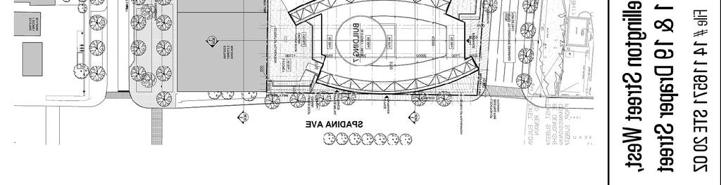
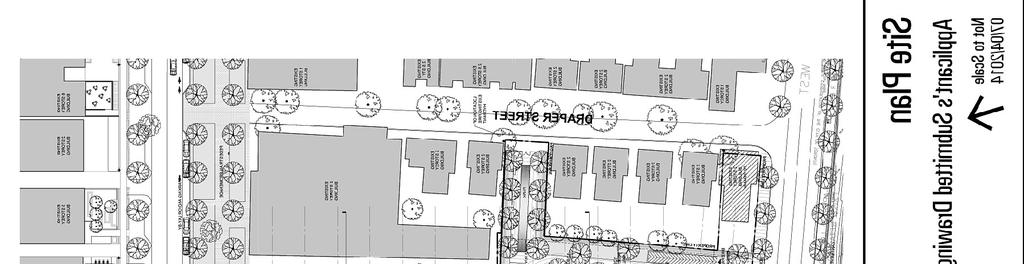
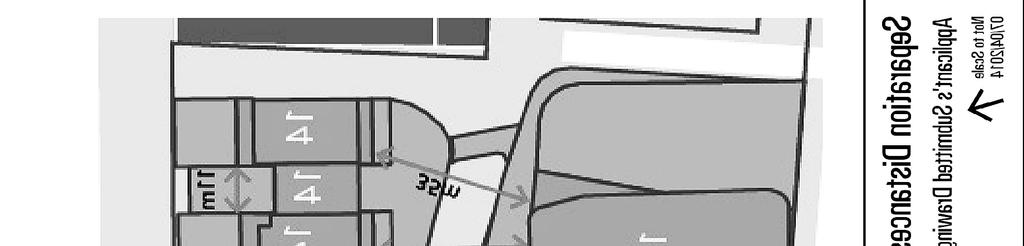
5 approximately 915 sq. metres for the 16-storey building to the west of that building and approximately 985 sq. metres for the 14-storey building at the west end of the site. Approximately 35% of the site is proposed to be developed as publicly accessible private open space, including two garden spaces and four north-south pedestrian pathways between Wellington Street and Front Street West and an east-west pathway which traverses the site from the corner of Spadina Ave. and Front Street West to a proposed garden on Draper Street. A portion of the proposed north-south pedestrian pathways are aligned with existing or potential pedestrian connections across Wellington Street West toward King Street to the north. These pedestrian connections range from 3 metres to 12 metres in width. A glass canopy would cover a part of the pedestrian pathway. The canopy would also be used to provide a pedestrian pathway at the second storey to provide access to the second storey retail uses proposed for all of the buildings on the site. The subject site include two parcels fronting on Draper Street, 1 and 19 Draper Street. The semi-detached house located at 1 Draper Street will be retained while the vacant parcel at 19 Draper Street is proposed to be incorporated into a garden and will provide a connection from Draper Street to the larger development site. The proposed development includes two privately owned, publicly accessible parks. One at the west end of the site adjacent Draper Street (and the park extension proposed for 19 Draper Street) and the other larger park closer to the middle of the site adjacent Wellington Street. The proposal also includes streetscape improvements on Wellington Street West and Front Street West. The Wellington Street frontage would include extensive tree planting and the creation of a pedestrian promenade to fulfill the objectives of plans dating back to the early 20 th century to create a green landscaped pedestrian promenade between Clarence Square and Victoria Memorial Park. Also proposed is a cantilevered pedestrian walkway on the south side of Front Street West and a 1.7 metre treed boulevard. See Attachment 1, Site Plan. All vehicular parking and servicing for the development is proposed to be located in four underground levels shared between the various buildings. A total of 2,136 parking spaces are proposed. Of this total, 158 visitor parking spaces for residential uses will be provided. The main point for vehicular access for the site is off Front Street West at the south-west corner of the site. There are two secondary vehicular access points off Wellington Street West at either end of the site. There are two pick-up/drop-off areas at the north-west and south-east corners of the site. There are 2,190 bicycle parking spaces proposed. Access for cyclists to the underground parking is provided by way of a dedicated bicycle ramp at the south-west corner of the site adjacent Draper Street. 5
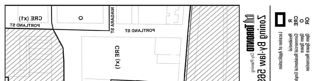
6 Site and Surrounding Area The subject site is 7.7 acres (3.1 hectares) in size and is bound by Spadina Avenue to the east, Draper Street to the west, Front Street West to the south and Wellington Street West to the north. The subject site excludes the property at the south-west corner of Spadina Ave. and Wellington Street West (49 Spadina Ave and 401 Wellington Street West). The building on this site, known as the Gale building and currently occupied by Stantec Engineering, was listed by Council on the Inventory of Heritage Properties on June 16, The subject site also includes two of the properties on the east side of Draper Stree t (1 and 19 Draper Street). 19 Draper Street is vacant and 1 Draper Street is occupied by a two storey semi-detached house. These two properties are included within the Draper Street Heritage Conservation District. The Front Street portion of the property measures metres, while the Spadina Avenue frontage measures 82.7 metres and the Wellington Street frontage measures metres. The property at 1 Draper Street has a frontage of 10.4 metres and the property at 19 Draper Street has a frontage of 12.0 metres. The site is occupied by large industrial and office buildings associated with the Globe and Mail newspaper and associated surface parking. The Toyota Dealership at the corner of Spadina Avenue and Front Street West has been demolished and the site is being used for surface parking. The site is surrounded by the following uses: North: The northern edge of the site is defined by Wellington Street West which has a right-of-way of 45 metres. Wellington Street is one of the oldest planned parts of the City and there have been plans dating back to the early 20 th century which would have seen the street landscaped to serve as a park connection between Clarence Square on the east side of Spadina Avenue and Victoria Memorial Park on the west side of Portland Street. The north side of Wellington Street West features an attractive streetscape treatment which reflects the wide City boulevard. On the north side of Wellington Street West at Spadina Avenue is a gas station. The buildings west of the gas station are predominantly older industrial buildings two to six storeys in height, which have been converted to office uses with some commercial uses at grade. The buildings at 422, 432, 436, 462, 468, 482 and 488 Wellington Street West are designated under Part IV of the Ontario Heritage Act. To the north and west of the properties on the north side of Wellington Street West is a mixed-use neighbourhood which evolved over the past twenty years in the West Precinct of the King-Spadina Secondary Plan area. This neighbourhood has developed with a predominantly mid-rise character with most buildings being 6
7 under 35 metres in height with the taller potions of these buildings being set well back from the street. The area includes many brick and beam former industrial buildings converted to office uses (the area is an important home for the City s cultural industries) as well as newer predominantly residential buildings. South: The southern edge of the site is defined by Front Street West with a right-of-way of 23 metes and the rail corridor to the south which is located in a trench with substantial retaining walls at its north and south boundaries. The rail corridor is approximately 100 to 120 metres wide, and provides a substantial separation between the subject site and the City Place development on the former railways lands south of the rail corridor. Approximately 50 metres west of the site extending across the rail corridor is the newly constructed Puente de Luz Bridge. This pedestrian and cycling bridge provides a link between the City Place development on the former railways lands south of the rail corridor and the neighbourhoods north of the rail corridor. City Place is a high-density tower neighbourhood with predominantly residential uses. West: To the immediate west of the site is Draper Street, which has a right-of-way of 10 metres. The southern half of Draper Street is flanked by a series of one and a half to two and a half storey brick homes which date back to the late 19 th century (the street was built out by 1890). This portion of the street and adjacent homes are a designated Heritage Conservation District under Part V of the Ontario Heritage Act (By-law No , passed by Council on February 4, 1999). To the west of Draper Street are a mix of low-scale commercial industrial buildings on the east side of Portland Street. Further to the west, the site at the corner of Front Street and Bathurst Street was the subject of a development application which resulted in the approval of a mixed-use building with heights up to 18-storeys (63 metres including mechanical elements (file No STE 20 OZ). East: The eastern edge of the site is defined by Spadina Avenue. Opposite the subject site the east side of Spadina Avenue is Clarence Square Park, one of only three significant green spaces within the King-Spadina Secondary Plan area. The lands east of Spadina Avenue are generally developing as a tower neighbourhood with the tallest buildings located closer to the financial district. Provincial Policy Statement and Provincial Plans The Provincial Policy Statement (PPS), 2014 provides policy direction on matters of provincial interest related to land use planning and development. These policies support the goal of enhancing the quality of life for all Ontarians. Key policy objectives include: building strong healthy communities; wise use and management of resources and protecting public health and safety. The PPS recognizes that local context and character is important. Policies are outcome-oriented, and some policies provide flexibility in their implementation provided that provincial interests are upheld. City Council's planning decisions are required to be consistent with the PPS. 7
8 The Growth Plan for the Greater Golden Horseshoe provides a framework for managing growth in the Greater Golden Horseshoe including: directions for where and how to grow; the provision of infrastructure to support growth; and protecting natural systems and cultivating a culture of conservation. City Council's planning decisions are required to conform, or not conflict, with the Growth Plan for the Greater Golden Horseshoe. Staff will review the proposed development for consistency with the PPS and for conformity with the Growth Plan for the Greater Golden Horseshoe. Official Plan The site is identified as being within the Downtown and Central Waterfront on Map 2- Urban Structures Plan. The Downtown and Central Waterfront is an area identified for growth. The site is designated Regeneration Area in the City of Toronto Official Plan which permits the proposed residential and commercial uses. The Regeneration area policies state that development within Regeneration Areas will be managed through a Secondary Plan, which will guide the revitalization of the area through such matters as: urban design guidelines; a greening strategy for improvements to existing parks and acquisition of new parks and open spaces; a community improvement strategy; a community services strategy; a heritage strategy; and environmental and transportation polices. The lands which comprise the Draper Street Heritage Conservation District are designated as Neighbourhoods. Policy states that... Development in Mixed Use Areas, Regeneration Areas and Apartment Neighbourhoods that are adjacent or close to Neighbourhoods will: a) Be compatible with those Neighbourhoods; b) Provide a gradual transition of scale and density, as necessary to achieve the objectives of this plan through the stepping down of buildings toward and setbacks from those Neighbourhoods; c) Maintain adequate light and privacy for residents in those Neighbourhoods; and d) Attenuate resulting traffic and parking impacts on adjacent neighbourhoods streets so as not to significantly diminish the residential amenity of those Neighbourhoods. Section of the City of Toronto Official Plan, states that significant heritage resources will be conserved. The interpretation policies of the Plan provided that use of the term "will" is prescriptive, to be interpreted as equivalent to "shall". The heritage policies of the Official Plan were revised and approved by Council (OPA 199, By-law No ) at its meeting of April 3, 2013, followed by approval from 8
9 the Minister of Municipal Affairs and Housing. These policies give additional direction and clarity. Section of the Official Plan addresses the need for park and open spaces. The Subject site is within an area identified as having the second lowest quantile of current provision of parkland. City staff have confirmed that they will be seeking a parkland dedication on the site. Chapter 3.3 deals with comprehensively planning new Neighbourhoods. These policies call for a comprehensive planning framework to reflect the City s Official Plan goals. This framework should include the pattern of development blocks, open spaces, a fine grain of interconnected pedestrian routes and a full range of housing. Chapter 6.16 of the Official Plan contains the King-Spadina Secondary Plan. The King- Spadina Secondary Plan reflects the polices established under the former Part II Plan approved in 1996 with the advent of the King-Spadina and King-Parliament Secondary Plans. The Secondary Plan was updated in 2003 as part of the development of the City s Official Plan, which was approved by the Ontario Municipal Board in The plan emphasizes the reinforcement of the characteristics and qualities of the area through special attention to built form and the public realm. In particular the policies of Section 3 Built Form specify that new buildings will achieve a compatible relationship with their built form context through consideration of such matters as building height, massing, scale, setbacks, stepbacks, roof line and profile and architectural character and expression. Buildings in the King-Spadina area shall also be sited and massed to provide adequate light, view and privacy for neighbouring properties. The Secondary Plan identifies a number of significant Streets, Open Spaces and Areas of Special Identity. Wellington Street West, Spadina Ave., Draper Street and Front Street West are identified as significant streets and open spaces. These areas are to be enhanced through streetscape improvements based on urban design guidelines. Wellington Street and Draper Street are identified as Areas of Special Identity. Mid-block connections are identified through the subject site to link Front Street West and Wellington Street West. The Plan states that the historical industrial buildings and large setbacks on the portion of Wellington Street West between Clarence Square and Victoria Memorial Park should act as a model for any redevelopment on the south side of the street. The north-west corner of Front Street West and Spadina Ave. is identified as a potential gateway site. The Secondary Plan also includes polices to protect heritage resources. The Secondary Plan states that the City will seek the retention, conservation, rehabilitation, re-use and restoration of heritage buildings. The Plan also provides for heritage density bonuses where the historic conservation, restoration and maintenance of heritage buildings is secured through Section 37 of the Planning Act. 9
10 An updated set of Urban Design Guidelines were approved by Council in 2006 as part of an exercise to update the King-Spadina Secondary Plan to acknowledge taller buildings being developed in the plan area east of Spadina Avenue. Zoning The eastern portion of the site is zoned Reinvestment Area (RA) by Zoning By-law , as amended (see Attachment 6 - Zoning). The RA Zone permits a range of residential uses, as well as commercial, institutional and limited industrial uses. As part of the RA zoning controls, density standards were replaced with built form objectives expressed through height limits and setbacks. The Zoning By-law permits a maximum building height of 61 metres at the corner of Front Street West and Spadina Ave., 39 metres fronting Spadina Ave. north of the corner, 30 metres fronting Front Street West and 23 metres fronting Wellington Street West. An additional 5 metres is permitted for rooftop mechanical elements. The Zoning By-law requires a 7.5m setback from the rear yard and from the side lot lines for areas over 25 metres from the street. Properties fronting on Draper Street are zoned as R3 Z1.0 and are subject to a 12 metre height limit. The subject property is also subject to two site-specific exemptions under By-law These exemptions apply to requirements under Section 12(2) to angular plane requirements (Exemption 260) and setbacks from the street and the location of principal entrances (Exemption 270). The site-specific exemptions were carried over to By-law On May 9, 2013 Council enacted a new comprehensive Zoning By-law, By-law ). The western portion of the site, comprising properties at 450 and 462 Front Street West, and 443 Wellington Street West are subject to the provisions of By-law , which zones these properties as CRE (Office Employment), which established permissions for use and built form generally similar to the RA Zoning under By-law The By-law established height limits of 30 metres adjacent Front Street West, 23 metres for properties fronting on Wellington Street West and 12 metres for properties on Draper Street. By-law is under appeal to the Ontario Municipal Board. Site Plan Control The proposed development is subject to site plan approval. An application for Site Plan Control has not been submitted. Official Plan Amendment and Urban Design Guidelines The proposed scale for the development would represent a departure from the existing King-Spadina Secondary Plan and the King-Spadina Design Guidelines (2006) which apply to the area. Planning staff requested that the applicant file an Official Plan Amendment application, to acknowledge the departure from the existing planning 10
11 framework represented by the proposal and to allow for the development of an updated planning policy framework for the redevelopment of this uniquely large property. A set of project-specific urban design guidelines will also be required to be developed to guide the development of the buildings and open spaces of what is anticipated to be a phased development. City-Wide Tall Building Design Guidelines In May 2013, Toronto City Council adopted the updated city-wide Tall Building Design Guidelines and directed City Planning staff to use these Guidelines in the evaluation of all new and current tall building development applications. The Guidelines establish a unified set of performance measures for the evaluation of tall building proposals to ensure they fit within their context and minimize their local impacts. The city-wide Guidelines are available at Built Heritage Resources The subject site is adjacent to (and includes two properties which are included within) the Draper Street Heritage Conservation District. Draper Street and adjacent homes are a designated heritage Conservation District under part IV of the Ontario Heritage Act (Bylaw No , passed by Council on February 4, 1999). The subject is also adjacent to the property at the south-west corner of Spadina Ave. and Wellington Street West (49 Spadina Ave and 401 Wellington Street West). The building on this site, known as the Gale building and currently occupies by Stantec Engineering, was listed by Council on the Inventory of Heritage Properties on June 16, With regard to the site itself, Heritage Preservation Services staff are currently evaluating the property at 439 Wellington Street West for possible designation under Part IV of the Ontario Heritage Act. Heritage Conservation District Study The King-Spadina Secondary Plan area contains many listed and designated heritage buildings. At its meeting on August 16, 2012 Toronto City Council directed Heritage Preservation Services staff to undertake Heritage Conservation District studies in five priority areas. One of these areas is the King-Spadina Secondary Plan area. The Request for Proposals for the King-Spadina Heritage Conservation District Study was issued and a team lead by Taylor-Hazell Architects has been chosen to undertake the study. The first phase of the study involves the identification of potential heritage conservation districts. The interim recommendations of the Heritage Conservation District Study were released at a public meeting held on March 18, The interim recommendation was to include the north half of the subject site within one of two potential heritage conservation districts identified for the King-Spadina Secondary Plan area. The draft 11
12 study findings will be presented at the May 23, 2014 meeting of the Toronto Preservation Board. The development of a Heritage Conservation District Plan and the designation under Part V of the Ontario Heritage Act of one or more identified Heritage Conservation Districts will follow as the second part of the study. Engineering and Construction Services Engineering and Construction Services staff have raised a number of concerns related to the ability of existing City services (water, sanitary and stormsewer services) to accommodate the proposed development. Addressing these issues will be an important part of the review of the proposed development. The applicant's Traffic Considerations Report was submitted on April 16, A preliminary evaluation is not available as of the writing of this report regarding the traffic and transportation issues associated with the proposed development. Staff will review that study and provide comments to the applicant regarding any issues raised. Tree Preservation There are 15 City-owned trees located on the City boulevard adjacent the subject site. The applicants Arborist Report recommends the removal of all of these trees. Urban Forestry staff are requiring that a detailed landscape plan be provided showing the planting of large growing shade trees within the City boulevard adjacent the subject site and the submission of a composite utility plan showing the location of all existing and proposed above and below-grade utilities. Tree planting within the City boulevard is to be to the satisfaction of the General Manager of Parks, Forestry and Recreation. There are 14 trees on the site which would qualify for protection under the City's Private Tree By-law. The trees are recommended for removal. Urban Forestry staff have requested a detailed landscape plan showing the planting plans for the site and have outlined the requirements for either planting replacement trees at a 1:3 ratio or for the payment of cash-in-lieu fees where planting of large growing shade trees is not possible. Specific instructions for planting above an underground structure have been provided as the entire site is to be excavated for underground parking. Reasons for the Application The applicant has submitted Official Plan and Zoning By-law Amendment applications to permit a mixed-use development with residential, retail and office uses in seven buildings. The proposed buildings range in height from 34-storeys and metres to 14-storeys and 54.1 metres. The proposed buildings substantially exceed the permitted building heights on the site which range from 61 metres to 23 metres. In additiona, the proposed development does not comply with other performance standards that are in effect on the lands. 12
13 COMMENTS Application Submission The following reports/studies were submitted with the application: - Plan of Survey - Site Plan and Statistics - Architectural Plans, Elevations and Sections - Tree Location Plan - 3-D Massing Model - Arborist Report and Tree Inventory - Stage 1 - Archaeological Assessment - Heritage Impact Assessment - Landscape Plan - Sun/Shadow Study - Pedestrian Level Wind Study - Functional Servicing Report - Toronto Green Standards Checklist - Community Services and Facilities Study - Economic Implications Report - High Level Ontario Building Code Design Brief - Urban Design Analysis and Planning Rationale (Submitted April 9, 2014) - Environmental Noise and Vibration Feasibility Study (Submitted April 11, 2014) - Transportation Impact Study (submitted April 16, 2014) A Notification of Complete Application was issued on April 22, Issues to be Resolved Issues to be addressed include, but are not necessarily limited to: - Staff requested that the applicant file an Official Plan Amendment to create a policy framework with which to evaluate the proposed development and provide a rationale for its much greater height and density within a neighbourhood which has been redeveloping very successfully for two decades. The applicants draft OPA captures some of the objectives which staff will want to incorporate into an amendment to the King-Spadina Secondary Plan if the application proceeds to approval. - The size and configuration of appropriate parkland dedication requirements. - The shadows cast by the development, including the proposed 34-storey (176.7 metres) office tower at the corner of Front Street West and Spadina Avenue on Clarence Square Park and the surrounding neighbourhood. 13
14 - Evaluation of the appropriateness of the Tall Building on the site and evaluation of the proposed with Tall Building Guidelines (Design Criteria for the Review of Tall Building Proposals) for floorplate sizes, base building massing and stepbacks for upper levels. - Determination of appropriate transition to the lower density mid-rise King- Spadina neighbourhoods to the north and west of the site and an appropriate transition is size and scale to the grade-related Neighbourhood and Heritage Conservation District on Draper Street. - Traffic, parking, site servicing and loading issues raised by Engineering and Construction Services and Transportation Services staff. Site servicing issues have been identified at an early stage as important issues which need to be addressed. - Impacts on the pedestrian realm, (including appropriate streetscape treatments and sidewalk widths) that may result from the intensity and scale of the proposed development. - The function the proposed internal pedestrian and servicing walkways / laneway needs to be understood both in the context of the existing proposal and the broader neighbourhood. The ownership of these laneways need to be clarified by the applicant and the means of securing public access to the proposed at-grade pedestrian walkways / servicing laneways needs to be determined. - The possibility of providing for vehicular access through the site as opposed to solely pedestrian access at grade. - The development of an appropriate set of urban design guidelines to shape the development of the site and to manage its continuing development through what is anticipated to be a multi-phased build out. - The appropriate conservation and preservation of the building at 439 Wellington Street West in the event staff determine that the building is to be designated under Part IV of the Ontario Heritage Act. If the building is to be designated, this should be done concurrently with the approval of any plans for the redevelopment of the site. - The submitted Heritage Impact Assessment does not provide a full analysis of the heritage issues relating to the site. Further information including the identification and evaluation of currently unidentified heritage resources on the site and the impact the proposal would have on them and on the heritage character of the King-Spadina area in general is required. 14
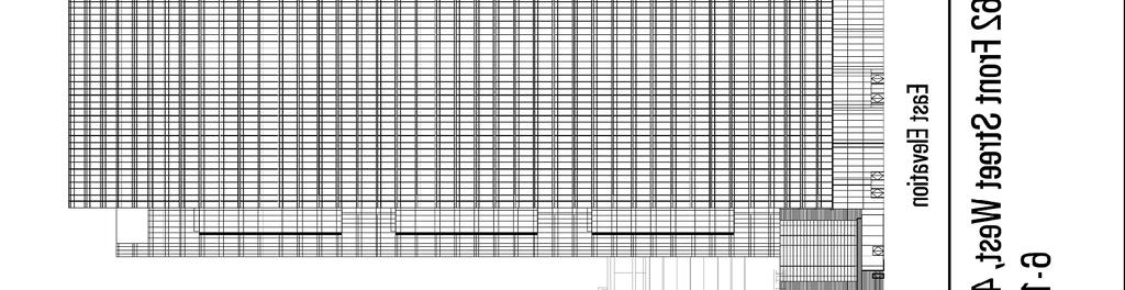
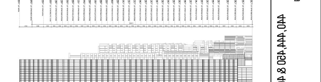
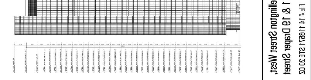
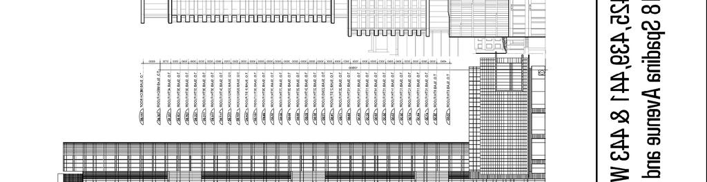
15 The TGS Checklist has been submitted by the applicant and is currently under review by City staff for compliance with the Tier 1 performance measures. Section 37 Should this project proceed to approval, appropriate Section 37 benefits will be assessed in accordance with Sections 5.1 and 7.2 of the King-Spadina Secondary Plan and secured as part of the final report and by-laws. These benefits may include such community services and facilities as daycare space or space for community use, securing a public art contribution and off-site public realm improvement. Additional issues may be identified through the review of the application, agency comments and the community consultation process. CONTACT Dan Nicholson, Senior Planner Tel. No. (416) Fax No. (416) dnichol2@toronto.ca SIGNATURE Gregg Lintern, MCIP, RPP Director, Community Planning Toronto and East York District (P:\2014\Cluster B\pln\TEYCC\ doc) - ca ATTACHMENTS Attachment 1: Site Plan Attachment 2: Buildings and Separation Distances Attachment 3: North Elevation Attachment 4: East Elevation Attachment 5: South Elevation Attachment 6: West Elevation Attachment 7: Zoning Attachment 8: Application Data Sheet 15
16 Attachment 1: Site Plan 16


17 Attachment 2: Buildings and Separation Distances 17

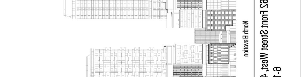
18 Attachment 3: North Elevation 18
19 Attachment 4: East Elevation 19
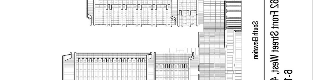

20 Attachment 5: South Elevation 20

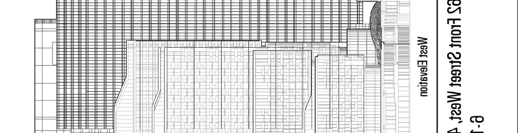
21 Attachment 6: West Elevation 21
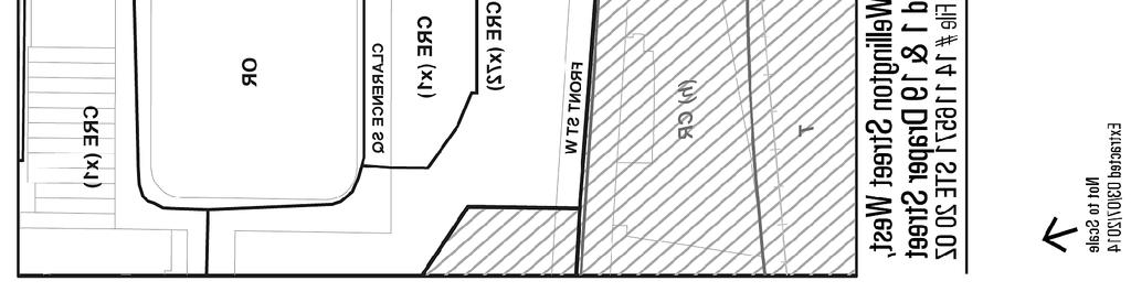
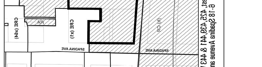
22 Attachment 7: Zoning 22
23 Attachment 8: Application Data Sheet Application Type Official Plan Amendment & Application Number: STE 20 OZ Rezoning Details OPA & Rezoning, Standard Application Date: February 12, 2014 Municipal Address: Location Description: Project Description: 440 FRONT ST W MIL RES SEC A LTS 8-10 PT LTS 7&11 SEC N LTS 2&4PL D196 LTS 1&2 PT LT 3 PL 209 LTS 1&19 PT LT 2 SEE NTE **GRID S2014 Proposed seven mixed use buildings with approximately 288,225 square metres of gross floor area including 98,260 square metres of office space, 52,922 square metres of retail space and 137,042 square metres of residential space. Applicant: Agent: Architect: Owner: Lucy Cameron Hariri Pontarini Architects Rad (Front Wellington) Nominee Inc. PLANNING CONTROLS Official Plan Designation: Regeneration Areas Site Specific Provision: ; King-Spadina Secondary Plan Zoning: RA Historical Status: Part of site within and adjacent to Draper Street HCD Height Limit (m): 30, 23, 12 Site Plan Control Area: Yes PROJECT INFORMATION Site Area (sq. m): Height: Storeys: 34 Frontage (m): 0 Metres: Depth (m): 0 Total Ground Floor Area (sq. m): Total Total Residential GFA (sq. m): Parking Spaces: 2316 Total Non-Residential GFA (sq. m): Loading Docks 20 Total GFA (sq. m): Lot Coverage Ratio (%): 53 Floor Space Index: 9.3 DWELLING UNITS FLOOR AREA BREAKDOWN (upon project completion) Tenure Type: Condo Above Grade Below Grade Rooms: 0 Residential GFA (sq. m): Bachelor: 0 Retail GFA (sq. m): Bedroom: 951 Office GFA (sq. m): Bedroom: 488 Industrial GFA (sq. m): Bedroom: 148 Institutional/Other GFA (sq. m): 0 90 Total Units: 1587 CONTACT: PLANNER NAME: Dan Nicholson, Planner 23
401, and 415 King Street West - Zoning Amendment Application - Preliminary Report
 STAFF REPORT ACTION REQUIRED 401, 407-409 and 415 King Street West - Zoning Amendment Application - Preliminary Report Date: January 27, 2011 To: From: Wards: Reference Number: Toronto and East York Community
377 Spadina Rd & 17 Montclair Ave Zoning Amendment Application Final Report
 STAFF REPORT ACTION REQUIRED 377 Spadina Rd & 17 Montclair Ave Zoning Amendment Application Final Report Date: September 14, 2016 To: From: Wards: Reference Number: Toronto and East York Community Council
440, 444, 450 and 462 Front Street West; 425, 439, 441 and 443 Wellington Street West and 6-18 Spadina Ave. Official Plan Amendment Final Report
 STAFF REPORT ACTION REQUIRED 440, 444, 450 and 462 Front Street West; 425, 439, 441 and 443 Official Plan Amendment Final Report Date: May 28, 2015 To: From: Wards: Reference Number: Toronto and East York
2433 Dufferin Street Zoning By-law Amendment Application - Preliminary Report
 STAFF REPORT ACTION REQUIRED 2433 Dufferin Street Zoning By-law Amendment Application - Preliminary Report Date: July 22, 2014 To: From: Wards: Reference Number: North York Community Council Director,
Toronto and East York Community Council. Acting Director, Community Planning, Toronto and East York District
 STAFF REPORT ACTION REQUIRED 440, 444, 450 and 462 Front Street West; 425, 439, 441 and 443 Wellington Street West; 6-18 Spadina Ave. and 1 and 19 Draper Street Urban Design Guidelines Final Report Date:
Spadina Avenue Built Form Study Preliminary Report
 STAFF REPORT ACTION REQUIRED Spadina Avenue Built Form Study Preliminary Report Date: July 9, 2014 To: From: Wards: Reference Number: Toronto and East York Community Council Director, Community Planning,
Bloor Street West Rezoning Application for a Temporary Use By-law Final Report
 STAFF REPORT ACTION REQUIRED 3741 3751 Bloor Street West Rezoning Application for a Temporary Use By-law Final Report Date: June 12, 2007 To: From: Wards: Reference Number: Etobicoke York Community Council
2175 Lake Shore Boulevard West Official Plan and Zoning Amendment, and Removal of the Holding Provision Applications Final Report
 STAFF REPORT ACTION REQUIRED 2175 Lake Shore Boulevard West Official Plan and Zoning Amendment, and Removal of the Holding Provision Applications Final Report Date: May 22, 2009 To: From: Wards: Reference
Toronto and East York Community Council. Director, Community Planning, Toronto and East York District
 STAFF REPORT ACTION REQUIRED Bloor Corridor/Annex Block Planning Study Official Plan Amendment Final Report Date: November 30, 2016 To: From: Wards: Reference Number: Toronto and East York Community Council
3450 Dufferin Street - Official Plan Amendment, Zoning Amendment and Draft Plan of Subdivision Applications Request for Directions Report
 STAFF REPORT ACTION REQUIRED 3450 Dufferin Street - Official Plan Amendment, Zoning Amendment and Draft Plan of Subdivision Applications Request for Directions Report Date: March 15, 2017 To: From: Wards:
URBAN DESIGN REPORT. Proposed Residential Development, Old Church Road, Caledon East
 Proposed Residential Development, Old Church Road, Caledon East TABLE CONTENTS: 1.0 DEVELOPMENT 1.1 Introduction-Analysis of Guiding Principles and Documents 1.2 Community Design and Architectural Design
Director, Community Planning, Toronto and East York District
 STAFF REPORT October 25, 2005 To: From: : Subject: Toronto and East York Community Council Director, Community Planning, Toronto and East York District Status Report OPA & Rezoning Application 05 117524
Town of Markham Yonge and Steeles Corridor Study and City of Vaughan Yonge Street Area Study
 STAFF REPORT ACTION REQUIRED Town of Markham Yonge and Steeles Corridor Study and City of Vaughan Yonge Street Area Study Date: August 14, 2009 To: From: Wards: Reference Number: North York Community Council
COLLEGE STREET STUDY Community Consultation Meeting. December 2015
 COLLEGE STREET STUDY Community Consultation Meeting December 2015 2 Agenda 6:30 pm Introductions, Agenda Review and Welcome 6:40 pm Presentation Planning Recommendations 7:30 pm Questions and Discussion
Director, Community Planning, North York District
 STAFF REPORT ACTION REQUIRED 3401 Dufferin Street and 1 Yorkdale Road - Yorkdale Shopping Centre Block Master Plan - Official Plan and Zoning By-law Amendment Applications - Preliminary Report Date: September
Director, Community Planning, Toronto and East York District
 STAFF REPORT April 24, 2006 To: From: Subject: Toronto and East York Community Council Director, Community Planning, Toronto and East York District Final Report Application to amend Zoning By-law as amended
Director, Community Planning, Toronto and East York District
 STAFF REPORT October 31, 2005 To: From: Subject: Toronto and East York Community Council Director, Community Planning, Toronto and East York District Final Report OPA and Rezoning Application 05 132450
Changing Lanes. Click to edit Master title style. Community Consultation Meeting #1. Second level Third level. Fourth level.
 Changing Lanes The Click City of to Toronto edit Master Review text of styles Laneway Suites Community Consultation Meeting #1 November 30, 2017 Agenda 6:30 Introductions Councillor Ana Bailão (Ward 18)
Changing Lanes. Click to edit Master title style. Toronto and East York Community Council. Second level Third level. Fourth level.
 Changing Lanes Toronto s Click to Laneway edit Master Suites text Strategy styles Toronto and East York Community Council May 2, 2018 2,433 Total number of Laneways in the City of Toronto 295 km Of Laneways
Inclusion on the City of Toronto's Heritage Register Midtown in Focus Phase 1: Main Street Properties
 PG22.5 REPORT FOR ACTION Inclusion on the City of Toronto's Heritage Register Midtown in Focus Phase 1: Main Street Properties Date: August 10, 2017 To: Toronto Preservation Board Planning and Growth Management
12, 14 and 16 York Street - Amendments to Section 16 Agreement and Road Closure Authorization
 REPORT FOR ACTION 12, 14 and 16 York Street - Amendments to Section 16 Agreement and Road Closure Authorization Date: April 27, 2018 To: Toronto and East York Community Council From: Senior Strategic Director,
Toronto and East York Community Council. Director, Toronto Building, Toronto and East York District
 Sign Variance - 25 Bishop Tutu Blvd STAFF REPORT ACTION REQUIRED Date: February 16, 2009 To: From: Wards: Reference Number: Toronto and East York Community Council Director, Toronto Building, Toronto and
Construction Staging Area Blue Jays Way (357 King Street West)
") REPORT FOR ACTION Construction Staging Area Blue Jays Way (357 King Street West) Date: June 8, 2018. To: Toronto and East York Community Council From: Acting Director, Transportation Services, Toronto
REPORT FOR ACTION Construction Staging Area Blue Jays Way (357 King Street West) Date: June 8, 2018. To: Toronto and East York Community Council From: Acting Director, Transportation Services, Toronto
Click to edit Master text styles 6:30 Walk around / Chat with Staff / View the Display Boards
 Changing Lanes Toronto s Click to Laneway edit Master Housing text Strategy styles Community Consultation Meeting March 29, 2018 Click Tonight s to edit Agenda Master title style 6:30 Walk around / Chat
Changing Lanes. Click to edit Master title style. Residents Associations Forum. Second level Third level. Fourth level.
 Changing Lanes Toronto s Click to Laneway edit Master Housing text Strategy styles Residents Associations Forum February 24, 2018 Agenda 11:00 Introductions / Ice Breaker / Your Expectations City Staff
Construction Staging Adelaide Street West
 REPORT FOR ACTION Construction Staging Adelaide Street West Date: October 6, 2016 To: Toronto and East York Community Council From: Acting Director, Transportation Services, Toronto and East York District
Draft Planning Controls Planning Scheme Amendment GC81
 Draft Planning Controls Planning Scheme Amendment GC81 Peita Tapper Senior Planner, Planning Services What the planning controls do? The draft planning controls translate the objectives and strategies
Parkland County Municipal Development Plan Amendment Acheson Industrial Area Structure Plan
 Parkland County Municipal Development Plan Amendment Acheson Industrial Area Structure Plan New Plan Acheson Industrial Area Structure Plan Amendment Parkland County Municipal Development Plan Board Reference
SUMMER VILLAGE OF SILVER SANDS. Municipal Development Plan
 SUMMER VILLAGE OF SILVER SANDS Municipal Development Plan Bylaw 253-2014 Adopted August 22, 2014 Summer Village of Silver Sands Municipal Development Plan Bylaw No. 253-2014 Page 2 1 INTRODUCTION 1.1 SETTING
REPORT. Bed and Breakfast Review - Land Use Policies and Regulations
 REPORT PLANNING AND DEVELOPMENT COUNCIL MEETING MEETING DATE: JANUARY 25, 2010 FROM: Planning Services DATE: January 4, 2010 PD: 011-10 SUBJECT: Bed and Breakfast Review - Land Use Policies and Regulations
SUBJECT: Downtown Mobility Hub draft New Precinct Plan and Policy Framework
 Page 1 of Report PB-68-17 SUBJECT: Downtown Mobility Hub draft New Precinct Plan and Policy Framework TO: FROM: Committee of the Whole - Workshop Planning and Building Department Report Number: PB-68-17
Re: Planning File #: B.17-W.1 ( )
") Date: March 1, 2013 To: Chair and Members Planning and Housing Standing Committee Re: Planning File #: B.17-W.1 (12-00287) 430-436 WATER STREET (Ward 2) Proposed Site Redevelopment 6-Storey Extension to
Date: March 1, 2013 To: Chair and Members Planning and Housing Standing Committee Re: Planning File #: B.17-W.1 (12-00287) 430-436 WATER STREET (Ward 2) Proposed Site Redevelopment 6-Storey Extension to
Concept Curtin Precinct Map and Code
 Concept Curtin Precinct Map and Code Proposed changes from the revised Curtin Group Centre Draft Master Plan recommendations Disclaimer: This document is intended to show the proposed changes to the existing
STAFF REPORT ACTION REQUIRED
 STAFF REPORT ACTION REQUIRED Proposed Area-Specific Amendment to Chapter 694, Signs, General, with Respect to Ricoh Coliseum and BMO Field and a Portion of Exhibition Place Date: July 23, 2014 To: From:
CONTENTS. 1 Introduction Always Moving Forward while Building on the Past A Dynamic Destination... 5
 2010 STRUCTURE PLAN - 2 - CONTENTS 1 Introduction... 5 1.1 Always Moving Forward while Building on the Past... 5 1.2 A Dynamic Destination... 5 2 Map A... 6 Exhibition Place and its Neighbours... 7 3 Demonstration
LIVE. WORK. PLAY. STATUS OF DEVELOPMENT FALL Produced for information by the Town of Markham
 LIVE. WORK. PLAY. STATUS OF DEVELOPMENT Produced for information by the Town of Markham Community TOWN OF MARKHAM CIVIC CENTRE 101 TOWN CENTRE BOULEVARD Completed in 1989. East of Town Centre Boulevard,
Pre-application submission for Committee: Phase 4 development at West Hendon
 Pre-application submission for Committee: Phase 4 development at West Hendon 1. Development Details Phase 4 of the West Hendon Estate Regeneration. 2. Background The redevelopment of the West Hendon Estate
Casa Loma Heritage Conservation District (HCD) Study. Community Consultation Meeting #1 Summary Report
 Study. Community Consultation Meeting #1 Summary Report") Casa Loma Heritage Conservation District (HCD) Study 1. Introduction Study Purpose In March 2015, Toronto City Council prioritized the Casa Loma neighbourhood for study as a potential Heritage Conservation
Casa Loma Heritage Conservation District (HCD) Study 1. Introduction Study Purpose In March 2015, Toronto City Council prioritized the Casa Loma neighbourhood for study as a potential Heritage Conservation
Lot Lot 25. Lot 24. Lot 23. Lot 22. congregate housing as a site specific permitted use at 633 Winnipeg Street (RD2 Zone).
.") Public Notice October 6, 2016 Subject Property: 633 Winnipeg Street Lot 6, District Lot 202, Similkameen Division Yale District, Plan 804 Application: Rezone PL2016-7738 The applicant is proposing to operate
Public Notice October 6, 2016 Subject Property: 633 Winnipeg Street Lot 6, District Lot 202, Similkameen Division Yale District, Plan 804 Application: Rezone PL2016-7738 The applicant is proposing to operate
ISTRIO MUNICIPALITY OF MUSKOK
 ISTRIO MUNICIPALITY OF MUSKOK.- -..-.. -.-... -- PLANNING AND ECONOMIC DEVELOPMENT DEPARTMENT 70 PINE STREET, BRACEBRIDGE, ONTARIO PI L 1 N3 Telephone (705) 645-2231 OR 1-800-461-4210 (705 area code) Fax
RESORT AREA STRATEGIC ACTION PLAN (RASAP) STEERING COMMITTEE MEETING - APRIL 3, 2019
 STEERING COMMITTEE MEETING - APRIL 3, 2019") RESORT AREA STRATEGIC ACTION PLAN (RASAP) STEERING COMMITTEE MEETING - APRIL 3, 2019 Welcome & Introductions - Deb Zywna AGENDA FY 20 Resort CIP Proposed Projects - Kathy Warren ORDFBC Design Guidelines
RESORT AREA STRATEGIC ACTION PLAN (RASAP) STEERING COMMITTEE MEETING - APRIL 3, 2019 Welcome & Introductions - Deb Zywna AGENDA FY 20 Resort CIP Proposed Projects - Kathy Warren ORDFBC Design Guidelines
Construction Staging Area 197 Redpath Avenue
 REPORT FOR ACTION Construction Staging Area 197 Redpath Avenue Date: January 31, 2017 To: Toronto and East York Community Council From: Acting Director, Transportation Services, Toronto and East York District
Pedestrian Safety Review Spadina Avenue
 STAFF REPORT ACTION REQUIRED Pedestrian Safety Review Spadina Avenue Date: October 13, 2015 To: Toronto and East York Community Council From: Director, Transportation Services, Toronto and East York District
Date: 11 th January, From: Plaistow & Ifold Parish Neighbourhood Plan - Steering Group. Plaistow & Ifold Parish Council
 Date: 11 th January, 2017 From: Plaistow & Ifold Parish Neighbourhood Plan - Steering Group To: Plaistow & Ifold Parish Council Re: Neighbourhood Plan Report to Parish Council Meeting 17 Jan 2017 The Steering
Disposition of Spadina Expressway Properties - Memorandum of Understanding with Infrastructure Ontario
 GM22.32 REPORT FOR ACTION Disposition of Spadina Expressway Properties - Memorandum of Understanding with Infrastructure Ontario Date: September 8, 2017 To: Government Management Committee From: Chief
Establishing a National Urban Park in the Rouge Valley
 STAFF REPORT ACTION REQUIRED Establishing a National Urban Park in the Rouge Valley Date: March 29, 2012 To: From: Wards: Reference Number: Executive Committee Deputy City Manager, Cluster B All p:\2012\cluster
City of Surrey PLANNING & DEVELOPMENT REPORT File:
 City of Surrey PLANNING & DEVELOPMENT REPORT File: 7917-0297-00 Planning Report Date: September 11, 2017 PROPOSAL: Amend CD By-law No. 18795 (based on RH-G). to allow for an increased house size on thirteen
KAP Lot 3. Lot 3. Lot Lot 5. Lot 6. Lot 7. Lot 8. Lot KAP 81153
 Public Notice April 26, 2018 Subject Property: 249 Westminster Ave W Lot A, District Lot 4, Group 7, Similkameen Division Yale (Formerly Yale Lytton) District, KAP92015 Application: Rezone PL2018-8201
LIVE. WORK. PLAY. STATUS OF DEVELOPMENT SPRING Produced for information by the City of Markham
 LIVE. WORK. PLAY. STATUS OF DEVELOPMENT SPRING 2013 Produced for information by the City of Markham Community CITY OF MARKHAM CIVIC CENTRE 101 TOWN CENTRE BOULEVARD East side of Town Centre Boulevard,
REGIONAL BOARD REPORT
 REGIONAL BOARD REPORT Administrator s Office For the Board August 21, 2008 DATE: August 14, 2008 FILE NOS.: A-07-06377/8/9.000 FROM: RE: Chief Administrative Officer OCP and Zoning Amendment Application
Heritage Character Area Zoning - Edmonton s Approach to Preserving(?) Community Character
 Community Character") Heritage Character Area Zoning - Edmonton s Approach to Preserving(?) Community Character Federation of Calgary Communities Community Planning Exchange November 4, 2017 City of Edmonton CITY
Heritage Character Area Zoning - Edmonton s Approach to Preserving(?) Community Character Federation of Calgary Communities Community Planning Exchange November 4, 2017 City of Edmonton CITY
AIRD & BERLIS LLP. Barristers and Solicitors. Kim M. Kovar Direct:
 Kim M. Kovar Direct: 416.865.7769 E-mail: kkovar@airdberlis.com November 18, 2013 BY EMAIL Councillor Peter Milczyn, Chair c/o Nancy Martins Secretarial Contact, Planning and Growth Management Committee
The District of North Vancouver FACT SHEET
 The District of North Vancouver Community Planning Dept. 355 West Queens Road North Vancouver British Columbia, V7N 4N5 COMMUNITY PLANNING FACT SHEET APPLICANT: THE SITE: Musson Cattell Mackey Partnership
2.1 TITLE: VMC PARKS MASTER PLAN AND IMPLEMENTATION STRATEGY PROJECT UPDATE
 2.1 Item: VMC Sub-committee Report DATE: Tuesday, June 12, 2018 WARD: 4 TITLE: VMC PARKS MASTER PLAN AND IMPLEMENTATION STRATEGY PROJECT UPDATE FROM: Jason Schmidt-Shoukri, Deputy City Manager, Planning
Chair and Members, The Etobicoke York Community Council. Mark Sraga, Director and Deputy Chief Building Official
 STAFF REPORT ACTION REQUIRED Sign Variance Report - Revised 29 Algie Avenue Date: January 11, 2010 To: From: Chair and Members, The Etobicoke York Community Council Mark Sraga, Director and Deputy Chief
Metrolinx Projects: Temporary Delegation for Long- Term Road Closures
 PW29.1 REPORT FOR ACTION Metrolinx Projects: Temporary Delegation for Long- Term Road Closures Date: April 24th, 2018 To: Public Works and Infrastructure Committee From: General Manager, Transportation
Airport Planning Area
 PLANNING AREA POLICIES l AIRPORT Airport Planning Area LOCATION AND CONTEXT The Airport Planning Area ( Airport area ) is a key part of Boise s economy and transportation network; it features a multi-purpose
STAFF REPORT FOR ACTION
 Insert TTC logo here STAFF REPORT FOR ACTION Hillcrest Complex Property Study Date: November 30, 2016 To: From: TTC Board Chief Executive Officer Summary This report outlines a plan for staff to proceed
Construction Staging Area 19 Western Battery Road
 REPORT FOR ACTION Construction Staging Area 19 Western Battery Road Date: December 6, 2017 To: Toronto and East York Community Council From: Acting Director, Transportation Services, Toronto and East York
PROCEEDING COMMENCED UNDER subsection 22(7) of the Planning Act, R.S.O. 1990, c. P.13, as amended
 of the Planning Act, R.S.O. 1990, c. P.13, as amended") DATE: January 13, 2018 CASE NO(S).: PL160942 PROCEEDING COMMENCED UNDER subsection 22(7) of the Planning Act, R.S.O. 1990, c. P.13, as amended Applicant and Appellant: Subject: Existing Designation: Proposed
DATE: January 13, 2018 CASE NO(S).: PL160942 PROCEEDING COMMENCED UNDER subsection 22(7) of the Planning Act, R.S.O. 1990, c. P.13, as amended Applicant and Appellant: Subject: Existing Designation: Proposed
places Mooloolaba s heart five
 five places the mooloolaba heart 1 Flexible community event use of school oval 2 Enhanced streetscape District cycle route Future cross-block pedestrian link 5 Existing school buildings New signalised
RECREATIONAL VEHICLE EXAMPLES
 RV Ordinance 21.03.010 (I). Recreational Vehicles. 1. Purpose. The purpose of the recreational vehicle (RV) code is to clearly define what is considered a recreational vehicle and to identify locations
KING STREET PILOT STUDY PUBLIC MEETING
 KING STREET PILOT STUDY PUBLIC MEETING 2017.02.13 PUBLIC WORK with GEHL STUDIO / NEW YORK SWERHUN ASSOCIATES SAM SCHWARTZ CONSULTING LLC STARTING POINTS 17 1 - TRANSIT FIRST! Transit service is beyond
PSP 75 Lancefield Road. Northern Jacksons Creek Crossing Supplementary Information
 PSP 75 Lancefield Road Northern Jacksons Creek Crossing Supplementary Information September 2017 The northern crossing of Jacksons Creek proposed within the Lancefield Road PSP is a key part of the ultimate
Welcome WINSTON GROUP. Welcome to our public exhibition on the Winston Group s proposals to redevelop 110 Walm Lane, Willesden Green.
 Welcome Our proposed scheme (image for illustrative purposes only) Welcome to our public exhibition on the Winston Group s proposals to redevelop 110 Walm Lane, Willesden Green. The purpose of our exhibition
COMMITTEE OF THE WHOLE (WORKING SESSION) APRIL 19, 2011 YORK REGION RAPID TRANSIT HIGHWAY 7 BUS RAPID TRANSIT- VMC STATION WARD 4.
 APRIL 19, 2011 YORK REGION RAPID TRANSIT HIGHWAY 7 BUS RAPID TRANSIT- VMC STATION WARD 4.") COMMITTEE OF THE WHOLE (WORKING SESSION) APRIL 19, 2011 YORK REGION RAPID TRANSIT HIGHWAY 7 BUS RAPID TRANSIT- VMC STATION WARD 4 Recommendation The Commissioner of Engineering and Public Works and the
COMMITTEE OF THE WHOLE (WORKING SESSION) APRIL 19, 2011 YORK REGION RAPID TRANSIT HIGHWAY 7 BUS RAPID TRANSIT- VMC STATION WARD 4 Recommendation The Commissioner of Engineering and Public Works and the
I508. Devonport Peninsula Precinct
 I508. Devonport Peninsula Precinct I508.1. Precinct description The purpose of the Devonport Peninsula precinct is to provide for the comprehensive residential development of the former Navy housing land
Toronto and East York Community Council
 STAFF REPORT ACTION REQUIRED Sign Variance Report 150 King Street West Date: February 21, 2008 To: From: Wards: Reference Number: Toronto and East York Community Council Acting Director, Community Planning,
Toronto and East York Community Council. Acting Director, Toronto Building, Toronto and East York District
 Sign Variance - 1580 Yonge Street STAFF REPORT ACTION REQUIRED Date: September 12, 2008 To: From: Wards: Reference Number: Toronto and East York Community Council Acting Director, Toronto Building, Toronto
As the Toronto Transit Commission (TTC) operates a transit service on Bay Street, City Council approval of this report is required.
 operates a transit service on Bay Street, City Council approval of this report is required.") REPORT FOR ACTION Construction Staging Area - 81 Bay Street Date: December 11, 2017 To: Toronto and East York, Community Council From: Acting Director, Transportation Services Toronto and East York District
REPORT FOR ACTION Construction Staging Area - 81 Bay Street Date: December 11, 2017 To: Toronto and East York, Community Council From: Acting Director, Transportation Services Toronto and East York District
DEVELOPMENT PERMIT STAFF COMMITTEE REPORT JUNE 19, 2013 CITY OF VANCOUVER PLANNING AND DEVELOPMENT SERVICES
 CITY OF VANCOUVER PLANNING AND DEVELOPMENT SERVICES DEVELOPMENT PERMIT STAFF COMMITTEE REPORT JUNE 19, 2013 FOR THE DEVELOPMENT PERMIT BOARD JULY 15, 2013 760 PACIFIC BOULEVARD (COMPLETE APPLICATION) DE408507/408622
STITCH TRANSFORMATIVE IDEA 3. SHORELINE STITCH. Re-connect the city to the waterfront and link the east and west Core Circle landscapes
 SHORE STITCH TRANSFORMATIVE IDEA 3. SHORELINE STITCH Re-connect the city to the waterfront and link the east and west Core Circle landscapes 126 LINE PUBLIC WORK 127 TRANSFORMATIVE IDEA 3. SHORELINE STITCH
Proposed Official Plan Amendment 41 to the Region of York Official Plan
 COMMITTEE OF THE WHOLE NOVEMBER 18, 2002 REGION OF YORK OFFICIAL PLAN AMENDMENT 41 THE OAK RIDGES MORAINE CONSERVATION PLAN Recommendation The Commissioner of Planning recommends: 1. That the City of Vaughan
Section Three, Part 14 Signs
 PART 14 SIGNS SIGNS 14.1 INTRODUCTION This part of the District Plan sets out the requirements in respect of signs. These matters were formerly controlled by bylaws. 14.2 OVERVIEW Signs form an integral
1 SUBWAY EXTENSION TO VAUGHAN CORPORATE CENTRE - OPERATING AGREEMENT UPDATE
 1 Report No. 1 of the Chief Administrative Officer Regional Council Meeting of June 21, 2007 THE REGIONAL MUNICIPALITY OF YORK REPORT NO. 1 OF THE REGIONAL CHIEF ADMINISTRATIVE OFFICER For Consideration
Toronto and East York Community Council. Director, Toronto Building, Toronto and East York District
 STAFF REPORT ACTION REQUIRED Sign Variance - 77 King St W Date: October 16, 2008 To: From: Wards: Reference Number: Toronto and East York Community Council Director, Toronto Building, Toronto and East
Madison Metro Transit System
 Madison Metro Transit System 1101 East Washington Avenue Madison, Wisconsin, 53703 Administrative Office: 608 266 4904 Fax: 608 267 8778 TO: FROM: SUBJECT: Plan Commission Timothy Sobota, Transit Planner,
Northwest Triangle. Redevelopment Proposal. Property Acquisition, Engineering, and Demolition. December, 2005 REDEVELOPMENT AUTHORITY OF THE
 Northwest Triangle Redevelopment Proposal Property Acquisition, Engineering, and Demolition December, 2005 REDEVELOPMENT AUTHORITY OF THE CITY OF YORK York City Redevelopment Authority 14 West Market Street,
Shadow Impact Assessment & 2323 Lake Shore Boulevard West. Etobicoke, Ontario
 Shadow Impact Assessment 2313 & 2323 Lake Shore Boulevard West Etobicoke, Ontario REPORT: GWE12-099-SHADOWS-2014 Prepared For: Peter Swinton, B.Arch., MCIP, RPP PMG Planning Consultants 227 Bridgeland
Economic Development and Tourism
 SECTION 4 SECTION 4 Economic Development and Tourism 4. Economic Development and Tourism Tourism plays a very important role in Niagara s economy, providing employment and generating business for support
Architectural Review Commission
 Architectural Review Commission staff report Item 3: Project Planner: Applicant/Owner: VITALITY BOWLS SIGNAGE APPEAL 100 CRESCENT DRIVE PLN 14-0473 Jeff Olsen, (925) 671-5206, jolsen@ci.pleasant-hill.ca.us
A Master Plan is one of the most important documents that can be prepared by an Airport.
 The Master Plan A Master Plan is one of the most important documents that can be prepared by an Airport. A Master Plan is a visionary and a strategic document detailing planning initiatives for the Airport
FORT YORK PEDESTRIAN & CYCLE BRIDGE
 FORT YORK PEDESTRIAN & CYCLE BRIDGE November 2006 urban design landscape architecture architecture DTAH This is a new concept for the Fort York Pedestrian and Cycle Bridge linking Stanley Park (South)
KING CONDOMINIUM RESIDENCES (REZONING)
") Kohn Partnership Architects Inc. Spadina Avenue, Suite 0, Toronto ON MV K Tel.0.00 www.kohnarchitects.com COPYRIGHT 00 KOHN ARCHITECTS INC. 0/0/0 REZONING KING CONDOMINIUM RESIDENCES (REZONING) ONTARIO
Kohn Partnership Architects Inc. Spadina Avenue, Suite 0, Toronto ON MV K Tel.0.00 www.kohnarchitects.com COPYRIGHT 00 KOHN ARCHITECTS INC. 0/0/0 REZONING KING CONDOMINIUM RESIDENCES (REZONING) ONTARIO
GUIDELINES RAILWAY LANDS WEST AND CENTRAL LOCATION URBAN DESIGN GUIDELINES
 Re-development in the former railway lands will be consistent with the following urban design guidelines. The guidelines correspond to the Railways Lands West and Central in Sections 18 and 19 of Chapter
Lafourche Parish Government REQUEST FOR QUALIFICATIONS. Landscape Architectural Services
 Lafourche Parish Government REQUEST FOR QUALIFICATIONS Landscape Architectural Services Bayou Lafourche Parish Multi-Use Path Feasibility Study Phase 1 And Bayou Lafourche Parish Multi-Use Path Feasibility
DECISION/DIRECTION NOTE
 DECISION/DIRECTION NOTE Title: St. John s Municipal Plan Amendment Number 134, 2017 and St. John s Development Regulations Amendment Number 617, 2017 Proposed Rezoning to the Commercial Neighbourhood (CN)
Bridge School, Longmoor Campus, Coppice View Road, Sutton Coldfield, Birmingham, B73 6UE
 Committee Date: 22/01/2015 Application Number: 2014/05949/PA Accepted: 08/12/2014 Application Type: Full Planning Target Date: 02/02/2015 Ward: Sutton Vesey Bridge School, Longmoor Campus, Coppice View
The optimum gross floor areas for the predominant land uses within Precinct Five are outlined below in Table 8.1.
 8.0 PRECINCT FIVE - CONVENTION CENTRE PRECINCT 8.1 Intent This Precinct is intended to function as an extension to the public purposes uses associated with the existing Performing Arts Complex. The primary
ARLINGTON COUNTY, VIRGINIA
 ARLINGTON COUNTY, VIRGINIA County Board Agenda Item Meeting of April 16, 2005 DATE: March 28, 2005 SUBJECTS: A. Adoption of the Fort Myer Heights North Plan. B. GP-300-04-1 Adoption of the following General
Ontario Municipal Board Commission des affaires municipales de l Ontario
 Ontario Municipal Board Commission des affaires municipales de l Ontario ISSUE DATE: February 27, 2015 CASE NO(S).: PL140972 PROCEEDING COMMENCED UNDER subsection 34(19) of the Planning Act, R.S.O. 1990,
E08. Kaufland Stores in Victoria Advisory Committee Epping. Request to be heard?:
 Kaufland Stores in Victoria Advisory Committee Epping E08 Request to be heard?: Yes Full Name: Organisation: Affected property: Attachment 1: Attachment 2: Attachment 3: Comments: Bernard McNamara BMDA
BAY CLOVERHILL COMMUNITY ASSOCIATION. Minutes of the Annual General Meeting November 14, 2016
 BAY CLOVERHILL COMMUNITY ASSOCIATION Minutes of the Annual General Meeting November 14, 2016 The Annual General Meeting of the Bay Cloverhill Community Association was held on Monday, November 14, 2016
Schedule of Planning Applications Committee Date: 23 May Reference: 06/18/0064/F Great Yarmouth Officer: Mr J Beck Expiry Date:
 Schedule of Planning Applications Committee Date: 23 May 2018 Reference: 06/18/0064/F Great Yarmouth Officer: Mr J Beck Expiry Date: 24-04-2018 Applicant: Proposal: Site: Mr Mavroudis Clear weather hoardings
Table of Contents TABLE OF CONTENTS. HOW THIS BY-LAW WORKS... i PART 1 - ADMINISTRATION, INTERPRETATION, ENFORCEMENT, AND DEFINITIONS
 TABLE OF CONTENTS Page Number HOW THIS BY-LAW WORKS... i PART 1 - ADMINISTRATION, INTERPRETATION, ENFORCEMENT, AND DEFINITIONS 1.1 ADMINISTRATION, INTERPRETATION AND ENFORCEMENT... 1.1 ~ 1 to 6 1.1.1 Within
Section 61 Recreational Vehicle Park / Campground (Bylaw No. 2012/10)
") Part 7 General Regulations Section 61 Recreational Vehicle Park / Campground (Bylaw No. 2012/10) 61.1 A comprehensive site plan shall be provided to the satisfaction of the Development Authority that shows
Part 7 General Regulations Section 61 Recreational Vehicle Park / Campground (Bylaw No. 2012/10) 61.1 A comprehensive site plan shall be provided to the satisfaction of the Development Authority that shows
Committee. Presentation Outline
 CW-33-15 11/9/2015 Community and Corporate Services Committee November 10, 2015 1 Presentation Outline Background Vision and Objectives Study Process and Timeline Public and Stakeholder Engagement Organization
Georgetown-Lewes Rail/Trail Study. Rail/Trail Study: Cool Spring to Cape Henlopen State Park New Road Extension (House Resolution No.
 Georgetown-Lewes Rail/Trail Study Rail/Trail Study: Cool Spring to Cape Henlopen State Park New Road Extension (House Resolution No. 47) August 22, 2011 Presentation Outline Background Benefits Statewide
4 VIVA PHASE 2 YONGE STREET - Y2, AND HIGHWAY 7 - H3 CORRIDORS PRELIMINARY ENGINEERING UPDATE
 4 VIVA PHASE 2 YONGE STREET - Y2, AND HIGHWAY 7 - H3 CORRIDORS PRELIMINARY ENGINEERING UPDATE The Rapid Transit Public/Private Partnership Steering Committee recommends the following: 1. The presentation
Nov. 29, 2007 PL Ontario Municipal Board Commission des affaires municipales de l Ontario. Judith Sellens and Claire Sellens
 ISSUE DATE: Nov. 29, 2007 PL060515 Ontario Municipal Board Commission des affaires municipales de l Ontario Judith & Claire Sellens have appealed to the Ontario Municipal under subsection 42(6) of the