Page 70 Custer & Washita Counties
|
|
|
- Archibald Davis
- 5 years ago
- Views:
Transcription

1 Page 70 Custer & Washita Counties

2 Beckham County Page 71


3 Page 72 Custer & Washita Counties FOSS continued from page 69 different Route 66 pathways brought trade and traffic. The drought and the Dust Bowl of the 1930s prompted many residents to move away. The interstate bypass forced businesses to close and caused the population to decrease. Foss City Hall, open Wednesdays only. (580) Things to do and see Kobel s Place. Foss Lake/State Park, approx. 5 miles north of Foss on Highway 44. (580) Schoolhouse Hill: On the north side of town, the School Alumni Association has created a park and monument on the site of the old school. It is north on Hwy. 44. Watch for signs. In town: 1894 church, west of Highway 44; City Park, north side of post office on Highway 44; pioneer jail in city park on west side of Highway 44; a twisted chimney; small round brick building. CANUTE For such a small community, Canute has a lot to offer the Route 66 traveler: a 1930s WPA Park, a group of historical markers near a median turnoff, and a Catholic cemetery with a 1928 grotto and Calvary Hill. All these sites are on the east side of town, on the old strip of Highway 66. Canute also has a 1918 jail (1/2 block west of Main on Scheidel), the Holy Family Church, the circa 1910 Hattie Walters Home (Main and Scheidel), and the old Cotton Boll and Washita Motels. At the intersection of Main and 66, there are some nice old service station buildings. Just east of Canute on the north side of I-40 is Clinton Lake, which was built in the 1930s by transient workers and the CCC. Canute City Hall, 6th and 66: (580) Things to do and see * KOA Kampground, I-40 at Exit 50, between Canute and Foss. * Route 66 Association member. 4

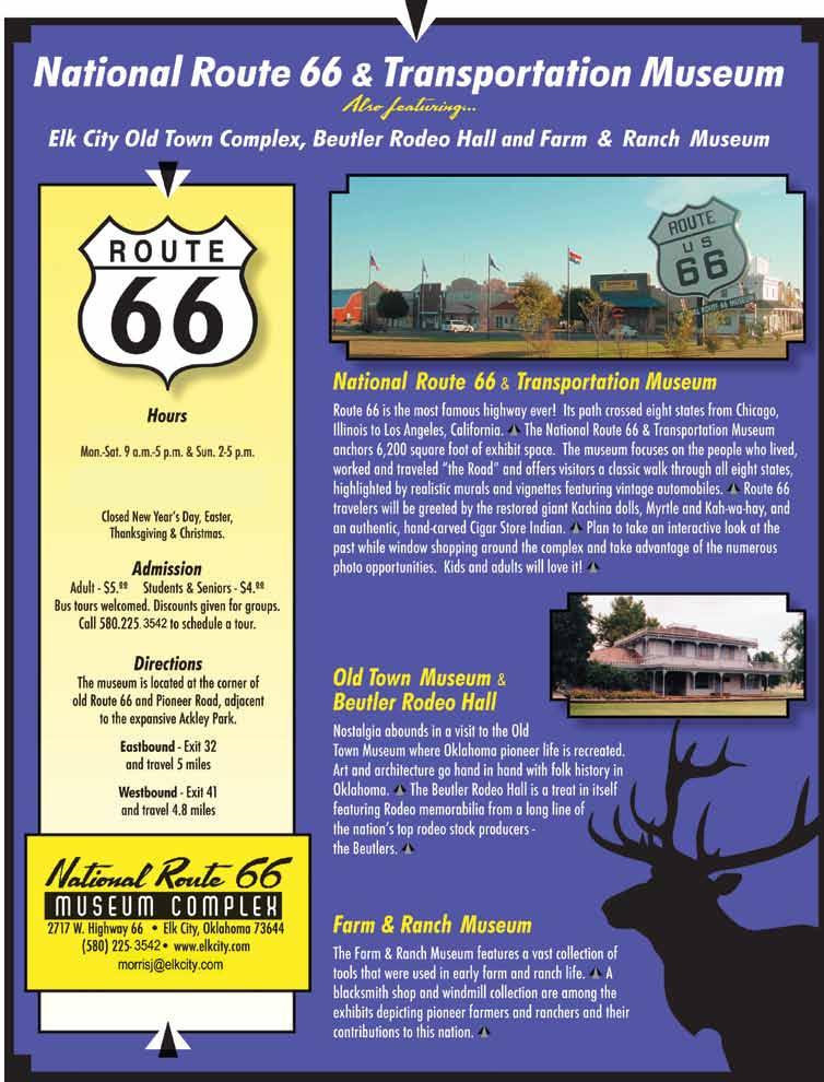
4 Beckham County Page 73 DID YOU KNOW? The giant kachina doll in front of the National Route 66 Museum in Elk City is named Myrtle.


5 Page 74 Beckham County Signage General Information Business 40 will take you through the towns of Erick, Sayre, and Elk City. Bus. 40 is also what part of the open country between Sayre, Erick, and Texola is called. The rest of it may or may not have county numbers. Don t follow Business 40 blindly, however. It will dump into I-40, particularly at either end of Sayre and Elk City. Between Erick and Texola, Bus. 40 turns north off Route 66, so be sure to continue straight. Street names of Route 66 in towns (east to west) Elk City: North frontage road State Highway 34 Airport Blvd. Bus. 40/East 66 Bus. 40/Van Buren Bus. 40/Third Sayre: Bus. 40/Hwy 66 Bus. 40/Fourth Erick: Roger Miller Blvd. Texola: Fifth Street Road Facts Between Elk City and Sayre you have two jogs across I-40 with a pretty yellow through truss bridge in between them. There aren t many locations on Oklahoma Route 66 that still have these erector-set-type bridges with the overhead structure. In Beckham County, much of 66 was originally paved in asphalt over a concrete base. Toward the western end, however, Portland cement was used.

6 Beckham County Page 75 ROADSIDE HIGHLIGHTS See if you can find the following landmarks: Older strip of 66 between Texola and Erick. Site of the Reptile Village. Abandoned north lanes between Erick and Sayre. Timber Creek through truss bridge. Old Queenan Trading Post, 66 and State Highway 6. Look for the building with the bell. Sayre Brine Station/Oklahoma Salt Works. Hint: two miles west of the jog from Business 40 onto the old road south of Sayre, then four-tenths of a mile north. ELK CITY Elk City or is it Busch? Both names have been applied to the town, especially when some enterprising folks tried to lure a brewery here, but after years of bitter debate, the name Elk City finally won out. A large elk sculpture was dedicated in It stands on the corner of Third (66) and Washington. Like Clinton, Elk City has Route 66 roots. In 1931, the U.S. Highway 66 Association held its annual convention here. More than 30,000 people attended. The site of the convention was the Casa Grande Hotel. In its heyday, the hotel was advertised as the only fireproof hotel between Oklahoma City and Amarillo. It is an easy building to spot: Just look for the 179-foot-tall oil derrick in its parking lot. The Old Town Museum on the west side of town keeps growing and growing. The complex includes an authentic turn-of-the-century gingerbread style home, a pioneer church, a one-room school, a railroad depot, a blacksmith shop, a farm and ranch museum, a creamery, a filling station, a funeral home, a Native American tepee, and, of course, the National Route 66 Museum. Further west is the Queenan Trading Post. Its name on the brick see ELK CITY, page 76 DID YOU KNOW? Children can join the Oklahoma Route 66 Association at a special discounted rate of just $10 per year.

7 Page 76 Beckham County RogeR MilleR MuseuM King of the Road Elk City continued from page 75 is faded, and the store is no longer in business, but both of the famous oil drum kachinas that once graced the front have been restored and stand proudly in front of the National Route 66 Museum. Wanda Queenan herself can often be found at the Museum. Along the Van Buren leg is an old cottage-style gas station. During the oil boom of the early 80s, Elk City underwent a flurry of building activity. Many classic Route 66 sites were lost, but the Van Buren stretch was spared. Elk City, like many towns in central and western Oklahoma, also has an older alignment of the Route. This one will lead you down a brick street. For more information, please consult Oklahoma Route 66 by Jim Ross. * Elk City Chamber of Commerce, P.O. Box 972. (580) elkcitychamber@ itlnet.net or visit Elk City Convention and Visitors Bureau. (580) Things to do and see Elk City Park, West 3rd and Pioneer. A WPA park. * National Route 66 Museum/ Old Town Museum, 66 and Pioneer Road. Summer hours 9 a.m. to 7 p.m. Mon.-Sat., 1 to 5 p.m. Sun. After Labor Day, 9 a.m. to 5 p.m. Mon.-Sat. and 2 to 5 p.m. Sun. (580) Old cottage-style service station, west side of North Van Buren. * 66 Association member. DOXEY Doxey is a ghost town. A cemetery is all that remains of the community, which was named after local rancher Sam Doxey. Doxey residents worked to promote the Postal Highway. When the Postal was changed to U.S. 66 in 1926, local boosters were excited to be part of the new highway system. Their excitement was shortlived: A newer alignment bypassed Doxey to the north in I-40 Exit 7 Route 66 Erick, Oklahoma (Located at stop light) Hours: Wed. - Sat. 10:00 to 5:00 Sun. 1:00 to 5:00 (580) Roger Miller memorabilia, music, photographs, videos, instruments, clothing, and more. Browse our gift shop!

8 Beckham County Page 77


9 Page 78 Beckham County SAYRE Sayre is the county seat of Beckham County, and its courthouse is quite impressive. If you have watched the movie The Grapes of Wrath recently, it may look familiar to you. It appeared in the montage of shots depicting the beginning of the Joad family s westward journey along Oklahoma Route 66. It is out of geographic context, however: It shows up before the family reaches the Pony Bridge near Bridgeport. Keep an eye out for the 66 building mural on the east side of town; Sayre Park s rock swimming pool; the WPA pedestrian tunnel; and the Art Deco Post Office with its 1930s mural of the Land Run. Sayre s downtown is on the National Register of Historic Places. * Sayre Chamber of Commerce, 117 N. Fourth. (580) * Sayre Main Street, 117 N. Fourth. (580) www. sayremainstreet.com. Things to do and see Beckham County Courthouse, E. Main. (580) RS & K Railroad Museum, 411 N. 6th. Open daily 9 to 9Groups welcome. Call first, or by appointment. Free. (580) Short Grass Country Museum and Historical Society, 106 E. Poplar. Located in Rock Island Depot. Open 2 to 4:30 p.m. Tues.-Fri. Free admission; donations welcome. (580) * Stardust Restaurant, 611 NE Hwy. 66. (580) * The Odd Shoppe, W. Main St. The Brick Coffee House/Treasures, 109 E. Main. (580) * Western Motel, 315 NE Hwy. 66. (580) Delhi From 1926 to 1928, Route 66 passed through the tiny community of Delhi, which is located southwest of Sayre, west of the municipal airport. The Delhi School Alumni Association and local citizens donated money for a monument to the town and school, showing its connection to 66. Erick As you drive the stretch of fourlane Mother Road between Sayre Photo by Emily Priddy Harley and Annabelle Russell, the Mediocre Music Makers, perform at the Sandhills Curiousity Shop for members of the Oklahoma Route 66 Association. and Erick, you will notice that it has been named the Roger Miller Memorial Highway, and 66 through town is called Roger Miller Boulevard. Miller cited his small-town upbringing in Erick as the inspiration for much of his music. At the stoplight, the cross street is named for Sheb Wooley, another native son, who played Pete Nolan on Rawhide and wrote the novelty song The Purple People Eater. * Erick Chamber of Commerce, 118 Roger Miller Blvd.: (580) oklahomawildlifetrails.com THINGS TO DO AND SEE * C&K Quick Stop, 306 Roger Miller Blvd. (580) * Oleta s Gift Shop, 801 S. Elm. (580) * Roger Miller Museum, SE corner of Roger Miller and Sheb Wooley. 10 a.m. to 5 p.m. Wed.-Sat.; 1 to 5 p.m. Sun. (580) www. rogermillermuseum.com SandHills Curiousity Shop. Downtown on Sheb Wooley. (580) th Meridian Museum, Sheb Wooley and Roger Miller. Tours by appt. (580) West Winds Motel, 619 W. Roger Miller Blvd. Classic tourist court. On the National Register of Historic Places. Oklahoma Visitor s Information Photo by Emily Priddy Myrtle the oil-drum kachina doll stands sentinel outside the National Route 66 Museum in Elk City. and Welcome Center, on I-40 9 miles east of the Texas border. Open 8:30 a.m. to 5 p.m. Box 419, Erick, OK (580) TEXOLA Over the years, the 100th Meridian has been surveyed eight different times. As a result, some people in the Texola area have lived in both Texas and Oklahoma without ever having moved. One block north of 66, on the easternmost street in town just before the road becomes a divided four-lane, you will see the Old Territorial Jail. Rumor has it that crime in Texola diminished during the witner months due to the jail s inhospitable conditions. Near the Texas-Oklahoma border is a Will Rogers Highway marker. Texola has no city hall, but you can call Double D at (580) or contact the Erick Chamber of Commerce for more information.
10
11 4
OKLAHOMA (Route 66 Mother Road s Glory Days)
") OKLAHOMA (Route 66 Mother Road s Glory Days) Little Rock to Fort Smith 159 mi. / 2 hr. 30 min. / I-40 Fort Smith to Oklahoma City - 182 miles / 2 hr. 53 min. / I-40 Oklahoma City to Erick (last city before
OKLAHOMA (Route 66 Mother Road s Glory Days) Little Rock to Fort Smith 159 mi. / 2 hr. 30 min. / I-40 Fort Smith to Oklahoma City - 182 miles / 2 hr. 53 min. / I-40 Oklahoma City to Erick (last city before
Things to do and see
 Page 48 Oklahoma County LUTHER Route 66 clips the north edge of town, but the highway never actually went through its heart. One glance at the old strips and berms on the south side of current 66 and old
OKLAHOMA'S HISTORIC ROUTE 66 AUDIO TOUR
 OKLAHOMA'S HISTORIC ROUTE 66 AUDIO TOUR Oklahoma s Historic Route 66 Audio Tour, created by the Oklahoma Historical Society, is an informative online audio tour that showcases the state's heritage and
Rogers County Page 19
 Rogers County Page 19 Landmarks See if you can find the following landmarks (listed in no particular order): A single arch truss bridge on westbound lanes. Water tower with a town s name and the 66 shield
Tour 12 - Historic Plumas County
 SPECIALTY tour 12 page 1 Tour 12 - Historic Plumas County This tour highlights many of Plumas County s historic attractions and small museums. Local experts may be available for tours or presentations
Inspiration Tower at Shepherd of the Hills Homestead.
 Inspiration Tower at Shepherd of the Hills Homestead. Getting Around Branson s Best 1 Town Where to Go First What to See First The Indispensable Time Saver Routes Welcome to Branson! Chapter 1: Getting
One of the quotes from the books was: Question - How long should I take to drive Route 66? Answer: Take as much time as you can.
 Foreword - Route 66. Hope some of the RSARS members and fellow "Armchair Travelers" will enjoy my adventure along America's Route 66. Many Europeans and other folks actually come and enjoy riding along
Paths, Plank Roads, and Planes
 S 10 Trail Summary HERITAGE TRAILS Paths, Plank Roads, and Planes Ride along the Paths, Plank Roads, and Planes trail and track the story of development and progress as written through the necessity of
Get Your Kicks on Route 66
 Get Your Kicks on Route 66 This week, we go for a ride through the colorful history of Route 66, a road that has been called "The Main Street of America. The idea for Route 66 started in Oklahoma. Citizens
Important Lane Closures March 1 5, 2010
 February 26, 2010 CONTACT: Marcia McAllister 703 572 0506 marcia.mcallister@dullesmetro.com Important Lane Closures March 1 5, 2010 C aisson Load Test Scheduled for Mar. 3 Crews will perform another load
BACKROADS BICYCLE/AUTOMOBILE TOUR OF MIDDLESEX, VERMONT
 BACKROADS BICYCLE/AUTOMOBILE TOUR OF MIDDLESEX, VERMONT (created and published by the Middlesex Historical Society) Welcome to a 25-mile self-guided historical tour of the backroads of Middlesex. You may
Corridor Management Plan for Virginia Coal Heritage Trail WMTH Corporation, 2011, trailsrus.com
 CHAPTER IV: HIGHLIGHTS Along the The St. Paul loop travels over 80 miles through the counties of Russell, Scott, Lee and Wise before ending back at St. Paul. As noted earlier, St. Paul holds the distinction
Welcome to The Town of Winfield SCOTT COUNTY, TN
 SCOTT COUNTY, TN Photo Tour and Recommendations The focus of Scott County tourism is as the Tennessee Gateway to the Big South Fork National Park, which is by far the largest tourism attractor to the region.
Coralville Limestone
 Coralville Limestone Coralville Parks and Recreation Created in 2016 pg. 1 Comprehensive Overview and Pricing Sheet Roundabouts Heartland drive ----------------------------------------------------------------------------------------------
CAE003 N ', W ' Columbia St. US 80 (and Market St.) once continued straight west from here. Continue east on Market St.
 once continued straight west from here. Continue east on Market St.") West to east. San Diego to Viejas Casino. CAE001 N 32 42.68', W 117 10.26' Harbor Dr and Pacific Hwy. Terminus of US 80 from 1943 to 1953. Pacific Hwy was US 101. CAE002 N 32 42.67', W 117 10.10' Harbor
West to east. San Diego to Viejas Casino. CAE001 N 32 42.68', W 117 10.26' Harbor Dr and Pacific Hwy. Terminus of US 80 from 1943 to 1953. Pacific Hwy was US 101. CAE002 N 32 42.67', W 117 10.10' Harbor
PACIFIC FISHERY MANAGEMENT COUNCIL CHAIR S RECEPTION. Saturday, March 5, :00 p.m. Second Floor Foyer Hilton Hotel Vancouver, Washington
 PACIFIC FISHERY MANAGEMENT COUNCIL CHAIR S RECEPTION Saturday, March 5, 2011 6:00 p.m. Second Floor Foyer Hilton Hotel Vancouver, Washington TO BE RETAINED BY OPERATORS OF HOTELS MOTELS, AND SIMILAR ACCOMMODATIONS
THE HIGHWAY 50 SURVIVAL CHALLENGE
 THE HIGHWAY 50 SURVIVAL CHALLENGE In July 1986, Life magazine described Nevada s Highway 50 from Ely to Fernley as the Loneliest Road in America. Life said there were no attractions or points of interest
CM RUSSELL DRIVE 248 miles [400km] 4 hours, 30 minutes
![CM RUSSELL DRIVE 248 miles [400km] 4 hours, 30 minutes](/thumbs/87/97334271.jpg "CM RUSSELL DRIVE 248 miles [400km] 4 hours, 30 minutes") CM RUSSELL DRIVE 248 miles [400km] 4 hours, 30 minutes Take US 87 north of Great Falls to historic Fort Benton. Drive into Fort Benton, once the world s most inland port as steamships carried supplies
CM RUSSELL DRIVE 248 miles [400km] 4 hours, 30 minutes Take US 87 north of Great Falls to historic Fort Benton. Drive into Fort Benton, once the world s most inland port as steamships carried supplies
THE HISTORIC River Street Ellijay, Georgia 30540
 THE HISTORIC 1907 24 River Street Ellijay, Georgia 30540 The 1907 restaurant building is located in the historic district of Ellijay, Georgia, and houses a retail dress shop in the lower left commercial
The Railroad in Alcolu, South Carolina
 Railway & Locomotive Historical Society, Inc. Southeast Chapter Newsletter No. 123 February 2011 Southeast Limited The Railroad in Alcolu, South Carolina On a trip to North Carolina and back to Florida
Below is the section of the Byway discussed in the Tazewell County meeting. Primary coal sites are noted on the map.
 APPENDIX H: PUBLIC PARTICIPATION SERIES OF TOWN MEETINGS Virginia Coal Heritage Trail Corridor Management Plan Meeting in Richlands on the Tazewell County portion of the Pocahontas Trail September 21 st
United States Department of the Interior National Park Service. Boundary Expansion Listed in National Register January 11, 2017
 NPS Form 10900-a (Rev. 8/2002) OMB No. 10240018 United States Department of the Interior National Park Service Boundary Expansion Listed in National Register January 11, 2017 National Register of Historic
Asheville & WNC Hikes
 Asheville & WNC Hikes Amazingly, we have 3,000+ miles of free public hiking trails near Asheville, including 1,600 miles in the Pisgah and Nantahala National Forests, 850 miles in Great Smokey Mountains
Bartlesville, OK July 7-9
 Bartlesville, OK July 7-9 Bartlesville is located 45 miles north of Tulsa, OK putting it within 2 ½ hours of Oklahoma City, OK: Wichita, KS and Fayetteville, AR. Bartlesville is less than three hours from
Of the Virginia Coal Heritage Trail
 CHAPTER III: ROUTE, MAPS & ROAD DESCRIPTIONS On the Virginia Coal Heritage Trail This Chapter addresses the #1 FHWA requirement for a CMP by providing maps identifying the corridor boundaries, location
Adult/Group Museums Visit Old Courthouse & Old Jailhouse Museums St. Agnes Convent & School Site
 Adult/Group Museums Visit Old Courthouse & Old Jailhouse Museums The History Center Washington County 320 S 5 th Ave, West Bend, WI 53095 (262) 335-4678 - www.historyisfun.com Contact: Jessica Sawinski
DRIVING TOUR OF PICKETT COUNTY TN THROUGH PHOTOS Traveling east on Hwy 111 starting at the Overton/Pickett County Line
 DRIVING TOUR OF PICKETT COUNTY TN THROUGH PHOTOS Traveling east on Hwy 111 starting at the Overton/Pickett County Line Welcome Sign as one enters County County Line Flea Market and Auction Historic Church
The Largest Quilt Barn Trail In Texas!
 The Largest Quilt Barn Trail In Texas! Fannin County Quilt Barn Trail Established 2012 - Over 100 squares and counting Join the Fun and Participate in the Quilt Barn Project Contact Patti Wolf for questions
PLACES TO WALK IN PORT COQUITLAM
 Places to Walk in Port Coquitlam Port Coquitlam is a walker s paradise, whether you re looking for a leisurely stroll or a challenging trek. Lace up your sneakers and try out these 18 walks submitted by
Bikes talk to each other like dogs, they wag their wheels and tinkle their bells, the riders let their mounts mingle.
 Bikes talk to each other like dogs, they wag their wheels and tinkle their bells, the riders let their mounts mingle. Daniel Behrman, The Man Who Loved Bicycles W hitmore Lake Loop route: Dexter, the corner
South Dakota RV Parks and Campgrounds. Three Flags RV Park and Camp. Hills RV Park BROKEN ARROW CAMPGROUND. Amenities
 1 South Dakota RV Parks and Campgrounds Three Flags RV Park and Camp Brief Description: Large pull thru RV sites 30' wide by 80' long. Park offers coin laundry, free cable TV with full hookups, free WiFi,
WELCOME 2018 POAC NATIONAL CONGRESS EXHIBITORS
 Clarion Inn & Suites Central I-44 3209 S. 79 th E. Ave. Tulsa OK 74145 (918)663-1000 WELCOME 2018 POAC NATIONAL CONGRESS EXHIBITORS Hotel & Room Amenities Include: Get A Bite in our Extended Continental
M U S E U M S. Bradford County. Experience an unforgettable journey through over two centuries of history.
 A COMPREHENSIVE GUIDE TO Bradford County PENNSYLVANIA Experience an unforgettable journey through over two centuries of history. M U S E U M S This is your official PASSPORT THROUGH HISTORY See contest
Kitimat. Pacific Inland Coast. Hiking Guide Kitimat, British Columbia, Canada
 Kitimat Pacific Inland Coast Hiking Guide Kitimat, British Columbia, Canada 2010-2011 Sites and Trails Emergency Call 911 Police - Fire - Medical 2 Welcome to Kitimat This information was produced to assist
SAMPLE. Branson Airport 53
 Branson Airport 52 SAMPLE Branson Airport 53 Shepherd of the Hills Adventure Park HOMESTEAD ADVENTURE PARK ALL NEW FOR 2018 AERIAL ADVENTURE ROPES COURSE. ROCK CLIMBING WALL OZARK OFF-ROAD ATV ADVENTURES.
2014 NW Regional Conference Registration and Schedule. Getting to Portland State University. Dick Baker: Maryann Brown:
 Welcome to the NW Regional Conference. Here is some information to help plan your time in Portland. We have planned a fun time for you and a chance to walk some very beautiful areas in Oregon and at Mt.
Introduction. Project Overview
 Washington Blvd./Andora Widening Project Community Open House & Public Scoping Meeting Summary Wednesday, September 21, 2016 6:00 7:30 p.m. Vencil Brown Elementary School, Roseville Introduction On Wednesday,
Oklahoma RV Parks and Campgrounds
 1 Oklahoma RV Parks and Campgrounds Rolling Stone Stables and RV Park Brief Description: Rolling Stone Stables and RV park is an 80 acre horse farm and RV park. We are located just 2 miles from I-40 for
1.2 Corridor History and Current Characteristics
 SECTION 1 Description and Background of Study Area 1.1 Introduction This preliminary engineering report was prepared for the Alaska Department of Transportation and Public Facilities (ADOT&PF). It is part
BEACH & DOWNTOWN VisiTOr MAp & GuiDE Revised July 2017
 BEACH & DOWNTOWN Visitor Map & Guide Revised July 2017 How to get here DRIVING DIRECTIONS From North Take Interstate 95 South to Exit 20 Turn left onto Hollywood Boulevard (east) Proceed east 2 miles to
Kiamichi Quilt Guild. December Debbie s Dialogue. Wishing everyone a very Blessed Holiday Season.
 December 2016 P.O. Box 1846 McAlester, OK 74501 Www.orgsites.com/ok/kiamichiquiltguild Email: Old High School Debbie s Dialogue Wishing everyone a very Blessed Holiday Season. Welcome to our guest: Wynoma
A leisurely one mile stroll through the history of Aldershot s Manor park, considered by many as the most attractive and pleasant parts of our town.
 Figure 1 Entrance to Park from the Aldershot Green/Churchill road end A leisurely one mile stroll through the history of Aldershot s Manor park, considered by many as the most attractive and pleasant parts
Overland Stagecoach Service through Tucson If it weren t for stagecoaches, Tucson wouldn t have developed to be the town we see today!
 Ring s Reflections by Bob Ring Overland Stagecoach Service through Tucson 1857-1880 If it weren t for stagecoaches, Tucson wouldn t have developed to be the town we see today! Let s set the stage (sorry).
Town of Limon Comprehensive Plan CHAPTER 6 TOURISM AND THE VISITOR ECONOMY
 CHAPTER 6 TOURISM AND THE VISITOR ECONOMY 65 VISION Limon s location at the intersection of Interstate 70, and Highways 24, 40, 71, and 287, provides steady traveler traffic with an estimated 80,000 overnight
Site Location and Setting
 Memorandum Date: To: From: Subject: Kristy Le, Gary Black Steve Orem Santa Teresa County Park Historic Area Traffic and Parking Study Hexagon Transportation Consultants, Inc. has completed a traffic and
OKLAHOMA DEPARTMENT OF TRANSPORTATION
 PROJECT NO.: STPY-0C()SS CALL ORDER: 00 COUNTY: ALFALFA DESCRIPTION: BID OPENING OF September 8, 0 September 8, 0 GRADE, DRAIN, SURFACE, AND BRIDGE J.P. NUMBER 0 PROPOSAL NUMBER: 0 HIGHWAY NO: US- US-:
Directions to Gathering/other Events:
 Directions to Gathering/other Events: Scroll down the list below (churches are in alphabetical order)!! Andrews Chapel UMC: From Conway: From Conway: Take 501 to Highway 31 North. Take the Highway 9 exit
Berg-en-Dal Rest Camp, Kruger National Park Access for Guests with Mobility challenges
 Berg-en-Dal Rest Camp, Kruger National Park Access for Guests with Mobility challenges Berg-en-Dal is in the scenically attractive south-western hills of the park. It is best accessed through the Malelane
18 th Annual Trail of Tears Commemorative Motorcycle Ride 2011
 For more information contact: Jerry Davis 256 218-0753 or ATTOTCA Website http://al-tntrailoftears.net IMMEDIATE RELEASE: September 2011 18 th Annual Trail of Tears Commemorative Motorcycle Ride 2011 BRIDGEPORT
Welcome to Scarborough, one of Maine s most historic communities and a town on the move! Located just five miles south of Portland, with easy access
 Welcome to Scarborough, one of Maine s most historic communities and a town on the move! Located just five miles south of Portland, with easy access to major turnpike and highway systems, Scarborough is
HISTORICAL MARKERS issued by
 HISTORICAL MARKERS issued by INDIANA HISTORICAL BUREAU in MONTGOMERY COUNTY, INDIANA 2016 Compiled by Dian Moore, Montgomery County historian NUMBER NAME 54.1962.1 Lane Place 54.1963.1 Major General Lew
Premier Office Space For Lease 111 Santa Rosa Avenue, Santa Rosa, CA
 Premier Office Space For Lease 111 Santa Rosa Avenue, Santa Rosa, CA 150 to 12,201 ± Sq. Ft. Available Westamerica Bank Building Downtown Underground and Surface Lot Parking Great Views From Upper Floors
Redesigning The Waterfront
 San Francisco Maritime National Park Service U.S. Department of the Interior National Historical Park California Redesigning The Waterfront A Self-Guided Walking Tour Then & Black Point Cove, ca. 1910.
Premier Office Space For Lease 111 Santa Rosa Avenue, Santa Rosa, CA
 Premier Office Space For Lease 111 Santa Rosa Avenue, Santa Rosa, CA 150 to 13,328 ± Sq. Ft. Available Westamerica Bank Building Downtown Underground and Surface Lot Parking Great Views From Upper Floors
KEYES MOUNTAIN RANCH $2,750,000
 KEYES MOUNTAIN RANCH $2,750,000 PREMIER ELK RANCH MITCHELL, OR 97825 ANDY WILBURN, BROKER 541-421-5300 O 541-421-3290 F 38498 FOX VALLEY RD LONG CREEK, OR 97856 RANCHBROKERAGE@YAHOO.COM WWW.WILBURNRANCHBROKERAGE.NET
Route 66 Dining & Lodging Guide - 15th Edition By Adopt-A-Hundred Program Adopters, National Historic Route 66 Federation READ ONLINE
 Route 66 Dining & Lodging Guide - 15th Edition By Adopt-A-Hundred Program Adopters, National Historic Route 66 Federation READ ONLINE PDF Good Night and God Bless: A Guide to Convent and Monastery Accommodation
FLAGSTAFF SELFIE TRAIL
 SELFIE TRAIL Use this trail map for directions to one-of-a-kind selfies available only in, the Destination for all Seasons. Experience the landscapes of the majestic Coconino National Forest and San Francisco
BRR Leg 1 (3.9 miles, Easy)
") BRR Leg 1 (3.9 miles, Easy) Min 3901 Max 4919 Ascent +21 Descent -1031 0.0 Start (Grayson Highlands State Park Visitor Center) 3.9 Grayson Highlands State Park Office & Gate, on R (EZ 1) Leg Notes: Minimal
BRR Leg 1 (3.9 miles, Easy) Min 3901 Max 4919 Ascent +21 Descent -1031 0.0 Start (Grayson Highlands State Park Visitor Center) 3.9 Grayson Highlands State Park Office & Gate, on R (EZ 1) Leg Notes: Minimal
Gardner: overview. Santa Fe, Oregon, and California National Historic Trails UNINCORPORATED JOHNSON COUNTY OLATHE UNINCORPORATED JOHNSON COUNTY
 Santa Fe, Oregon, and California ational Historic Trails : overview 99: p.134 100: p.135 GARDER JUCTIO 102: p.137 56: p.126 EDGERTO Burlington orthern Intermodal and Logistics 98: p.133 101: p.136 S Waverly
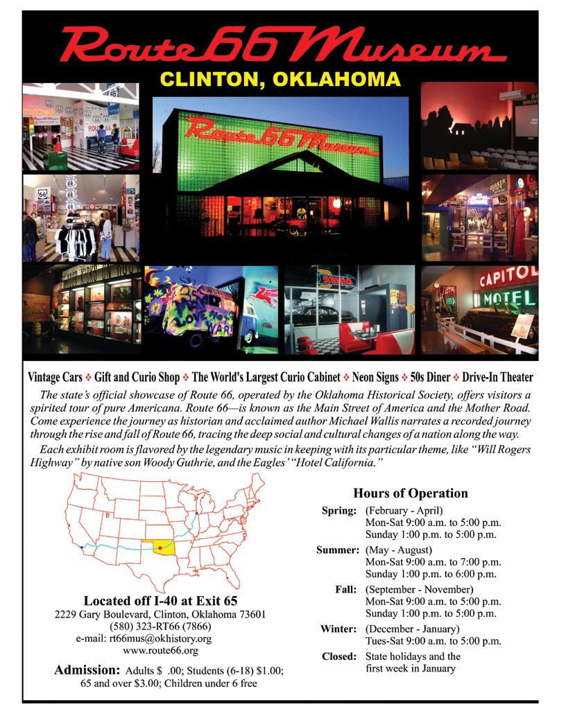
Oklahoma Route 66 Association Trip Guide Gen. Thomas Stafford Museum Weatherford Oklahoma Route 66 Museum Clinton Roger Miller Museum Erick
 Oklahoma Route 66 Association Trip Guide Gen. Thomas Stafford Museum Weatherford Oklahoma Route 66 Museum Clinton Roger Miller Museum Erick Teamwork Makes the Dream Work Stroud Chamber 216 West Main Street
IAT NS CAPE BRETON - NORTH SYDNEY TO PORT HASTINGS (SOUTHBOUND)
") NORTH SYDNEY TO GRAND NARROWS - 61.4 KM WELCOME TO NORTH SYDNEY, CAPE BRETON ISLAND, NOVA SCOTIA! North Sydney is a major city with a CAPs (public internet access) & all amenities. Rollies Wharf Restaurant
NORTH SYDNEY TO GRAND NARROWS - 61.4 KM WELCOME TO NORTH SYDNEY, CAPE BRETON ISLAND, NOVA SCOTIA! North Sydney is a major city with a CAPs (public internet access) & all amenities. Rollies Wharf Restaurant
Village of Harrisville and Town of Diana
 Village of Harrisville and Town of Diana Resources are located between NYS DOT End Mile Point Lewis County Line 00.00-11.43 & St. Lawrence County 00.00-7.90 Joseph Bonaparte (former King of Spain and brother
THE RETINA INSTITUTE Post-Operative Appointment
 Post-Operative Appointment Date: Time: Location: Doctor: On the attached sheets you will find directions to the office where you will see a doctor for your appointment. There is a map for each possible
Information For Planning A Trip To The Tehachapi Loop. Jeff Williams September, 2016
 Information For Planning A Trip To The Tehachapi Loop Jeff Williams September, 2016 Note: This slide show is a scaled down version of the presentation made to the San Jacinto Model Railroad Club September
Trail Etiquette. Hours of Operation. Trail Accessibility
 Trail Guide The Elmhurst Park District, with 28 parks and over 460 acres of land, offers nearly six miles of paved or asphalt park trails and maintains an additional 3.6 miles of trails within Elmhurst.
Community Newsletter
 Community Newsletter Week of March 12-16, 2018 A publication of the City of Dodge City Public Information Office 1. Cavalier Field recently received a new scoreboard measuring 36 wide. The new scoreboard
South Dakota RV Parks and Campgrounds
 1 South Dakota RV Parks and Campgrounds Three Flags RV Park and Camp Brief Description: Large pull thru RV sites 30' wide by 80' long. Park offers coin laundry, free cable TV with full hookups, free WiFi,
Driving Directions from San Jose Airport to Paradise Breezes
 Driving Directions from San Jose Airport to Paradise Breezes From the rental agency head towards San Jose on the airport highway. At approximately 12.5Km (approximately 10 minutes from airport) you will
Blues Highway Blues By Christopher Price, Eyre Price
 Blues Highway Blues By Christopher Price, Eyre Price Road Trip Down the Blues Highway, U.S. Route 61 road trip makes stops at B.B. Kings Blues Club, Union Station Hotel, Memphis Rock n Soul Museum and
Past practice - Fernie Derrick restoration
 Published August 26, 2011 INDUSTRY NEWS Past practice - Fernie Derrick restoration James Waterman Staff Writer About one hundred years ago, aspiring oilmen tried their luck in the environs of Akamina Creek
Merchant Open Houses. Horse-drawn Carriage & Wagon Rides. It s New Once Again 106 West Main Street 5-8 pm Friday 10 am-8 pm Saturday
 Merchant Open Houses A Beautiful Purpose 108 West Main Street 6-8 pm Friday 12-8 p.m. Saturday Brick Arch Winery 116 West Main Street 6-8 pm Friday 12-8 p.m. Saturday Cornerstone Real Estate 109 East Main
SHASTA WEST PLANNING AREA
 2016 SHASTA COUNTY COMMUNITY WILDFIRE PROTECTION PLAN SHASTA WEST PLANNING AREA Covering the communities of: Centerville Redding (west & downtown) Shasta I. PROPOSED PROJECTS A. THE PLANNING AREA SHASTA
The View at Bankhead Lake 12 miles off new Interstate Corridor X
 The View at Bankhead Lake 12 miles off new Interstate Corridor X offers the opportunity to the first to view 6 beautiful waterfront lots on Bankhead Lake to be released Saturday August 25th. Appointment
New Guadernales 64 miles
 Cycling Route 64 miles Region: Fredericksburg, Texas Author: Gregory L. Kagay Catalog: 1022.1 Route Elevation Profile 5,000 Feet 4,000 3,000 2,000 Center Point Slope Bat Cave Summit Piedmont de San Antonio
Trailside Park, Herndon
 Trailside Park, Herndon Herndon is not the little rail stop it used to be. Like many of the smaller towns around Washington, D.C. Herndon has grown and changed. It even installed it s own little beltway,
GTOAA ROUTE 66 STREET LEGENDS CRUISE DAY 1 SEPT 17 MONDAY
 DAY 1 SEPT 17 MONDAY Starting Location: Pontiac, Illinois front of Pontiac Museum 8:00 AM Miles to go today: 160 Stops along the way: Funk s Grove Maple Sirup; Illinois State Capital; Old Brick section;
AUCTION BIDDING You may bid online during the auctions at www. LIVE ONLINE PORTFOLIO OVERVIEW
 PORTFOLIO OVERVIEW STATE COUNTY/ PARISH ACRES CROPLAND (FSA) AUCTION DATE Illinois Mercer 4,869± 4,657± Illinois Fulton 3,769± 3,596± December 12 Texas Hartley 11,240± Texas Moore 920± 11,646± December
Prepared for Travel Oregon by Kathi Jaworski, Write to Know consulting
 1 2 3 4 5 o 6 7 8 9 Coos County Employment by Industry, 2006-2015 Top Categories of Employment (500+ Jobs) 5,000 4,500 4,000 3,500 3,000 2,500 2,000 1,500 1,000 500 2006 2010 2015 Source: Oregon Employment
May - June 2003!" Vol. 25, No. 3. Newsletter of the Cultural Resources Division!" Kansas State Historical Society
 May - June 2003!" Vol. 25, No. 3 Newsletter of the Cultural Resources Division!" Kansas State Historical Society Over the years, Route 66 developed a mythical stature. While just over thirteen miles of
Guide to the Virginia "Teddy" Fenton Photograph Collection on the Hoover Dam and Boulder City, Nevada
 Guide to the Virginia "Teddy" Fenton Photograph Collection on the Hoover Dam and Boulder City, Nevada This finding aid was created by Lindsay Oden on April 27, 2018. Persistent URL for this finding aid:
Springettsbury Township. Road Improvement Projects
 Springettsbury Township Road Improvement Projects 2009 2016 2016 Township Road Improvement Projects Springettsbury Township is divided into the following 4 Sectors: Northwest Sector Sherman Street Route
The Largest Quilt Barn Trail In Texas! Really!!!
 The Largest Quilt Barn Trail In Texas! Really!!! Fannin County Quilt Barn Trail Established 2012 - Over 100 squares and counting Join the Fun and Participate in the Quilt Barn Project Contact Patti Wolf
Coos Bay Then and Now Quest
 Coos Bay Then and Now Quest Oregon Coast Quests is an Oregon Sea Grant program based at Oregon State University's Hatfield Marine Science Center. 160 The Oregon Coast Book, 2017 18 Edition Use this map
Now Leasing for Nov. 1, 2017 Grand Opening
 South Florida s newest and hottest retail, restaurant, and entertainment location in Hallandale Beach; just north of Miami s Aventura area, minutes south of Fort Lauderdale-Hollywood International Airport
Route 29 Business Replacing bridge over river and railroad in Altavista. Signed detour in place.
 EASTER 2019 VDOT will lift most lane closures for holiday travel from noon Friday, April 19 until noon Tuesday, April 23. However, motorists may encounter semi-permanent work zones or travel delays in
FREE Summer Things for Families to Do in Gulfport, MS
 FREE Summer Things for Families to Do in Gulfport, MS GULFPORT BEACH The beach is always free and is a fun place to go. Bring lunch, spend the day and create memories. Fire Pits in designated areas are
DISCOVER THE DIFFERENCE OF A LANDMARK LOCATION.
 DISCOVER THE DIFFERENCE OF A LANDMARK LOCATION. AMENITIES OCATION OVERVI CENTRALIZED The Towers at Williams Square is located in the heart of North Texas, just 15 minutes from downtown Dallas, DFW International
The Newsletter of the Red River Valley Railroad Historical Society, Inc.
 The Newsletter of the Red River Valley Railroad Historical Society, Inc. October, 2009 Shreveport, LA Our 28 th Year Gone But Not Forgotten: Standard Wood Preservers of Shreveport Standard Wood Preservers
Jackson County Historical Society News
 Jackson County Historical Society News volume twenty, number one november 2012 The Jackson County Historical Society will meet at the First Christian Church of Jefferson on Sunday, November 11, 2012, at
Seniors We Are Etc. FOR YOUR SAFETY
 Seniors We Are Etc. Orlando Florida 7 Days/6 Nights Departing from: Start Date: Sunday, September 25, 2011 New Bethleham Baptist Church 12707 Cullen Boulevard (Front Parking Lot) Houston, TX 77048 Bus
BOOGIE WOOGIE AUTO TOUR 1
 BOOGIE WOOGIE AUTO TOUR 1 4 6 3 5 7 1 2 10 9 8 Route # 1 Alternate Return Route 1 Historic Harrison County Courthouse & Museum 2 Texas & Pacific Railway Depot & Museum 3 Antebellum Childhood Home Lady
HISTORIC ROUTE 20. Iowa. A guide for the implementation of Historic Route 20 signs in. The City of Dubuque The County of Dubuque Iowa
 HISTORIC ROUTE 20 Iowa A guide for the implementation of Historic Route 20 signs in The City of Dubuque The County of Dubuque Iowa Prepared by the Historic US Route 20 Association Inc. February 2018 Introduction
MINNESOTA ARCHITECTURE - HISTORY INVENTORY FORM Property Location
 MINNESOTA ARCHITECTURE - HISTORY INVENTORY FORM ------ - Property Location -- ---- Property Name: Washington Park Address: 215 N 4th Street County: Blue Earth City/Twp: Mankato PIN: R01.09.07.461.001 Legal
Northwest Arkansas Heritage Trail Plan
 Northwest Arkansas Heritage Trail Plan A regional network of bicycle and pedestrian facilities that connects Northwest Arkansas citizens and visitors to our rich heritage, our recreational and cultural
Calgary City Tour #2
 Calgary City Tour #2 July 16, 2019 Field Trip Leader: Dave Dearborn Free Number of Participants: 12 ww.ccc2019.ca Canadian Camera Conference 2019 Colourful wall art in downtown Calgary. What s in a Name
Stillwater and USRI Guide Oklahoma State University
 Stillwater and USRI Guide Oklahoma State University POC: Jamey Jacob and Rick Gaeta Oklahoma State University rick.gaeta@okstate.edu 405-744-5900 Unmanned Systems Research Institute Oklahoma State University
Friday Evening, Saturday Afternoon & Evening Soldiers & Sailors Memorial Hall
 PittStop Lindy Hop 2011 Directions to Dances Friday Evening, Saturday Afternoon & Evening Soldiers & Sailors Memorial Hall Street parking: Must pay the meters until 6pm. Parking lot underneath Soldiers
Northeast Corridor Transportation Update
 Northeast Corridor Transportation Update Presented by: Stuart Basham Division 10 Planning Engineer North Carolina Department of Transportation October 2, 2014 Today s presentation includes: I-485 Outer
2015%Ironbound%Spring%Warmup% Directions!
 Riverfront Park 3 Brill St (Corner of Brill St and Raymond Boulevard) GSP Parkway: EXIT 145 to Route 280 East Exit 16 (Harrison Ave), make right at F.E. Rodgers Blvd, go past Wendy's, Path Station, cross
Brisbane to Toowoomba Town Hopper
 jhdfjkhdksfhdhjf Brisbane to Toowoomba Town Hopper Brisbane to Toowoomba via Flagstone Creek Road Head off the beaten track and discover some of the charming towns and great sights to be seen on your journey