Park-and-Ride Study: Inventory, Use, and Need. For the Roanoke and New River Valley regions
|
|
|
- Daisy Armstrong
- 6 years ago
- Views:
Transcription

1 Park-and-Ride Study: Inventory, Use, and Need For the Roanoke and New River Valley regions
2 Contents Background... 1 Study Area... 1 Purpose... 2 Methodology... 3 Existing Facilities... 4 Performance Measures... 9 Connectivity... 9 Capacity... 9 Access General Conditions Education Way finding signs Virginia RIDE Solutions Recommendations New and Expanded Facilities: I-81 Exit New and Expanded Facilities: I-81 Exit New and Expanded Facilities: I-81 Exit New and Expanded Facilities: Route 220 at Boones Mill General Conditions Way finding References Appendix 1: Sample Park-and-Ride Lot Inventory Form Appendix 2: Photograph inventory of Park-and-Ride Lots Appendix 3: Aerial photographs of Park-and-Ride Lots... 27
3 Background Park-and-Ride facilities provide a common location for individuals to transfer from a lowoccupancy vehicle to a higher-occupancy vehicle. This can involve transferring to a carpool, vanpool, or to a transit system. Regional Park-and-Ride lots allow commuters, particularly those who commute out of their community and those who live in rural areas, to park their vehicles at convenient location in order to finish their commute using alternative transportation, such as meeting their carpool partners or using transit. As a result, most Park-and-Ride lots are oriented toward providing sufficient automobile parking to facilitate ride-sharing and transit. Robert Spillar (1997) identifies Park-and-Ride lots as a connection to transit systems and Park-and-Pool lots are principally for ridesharing (carpooling and vanpooling). For the purposes of this study, the term Park-and-Ride is used in reference to both kinds of lots. Park-and-Ride facilities can help maximize the efficiency of the transportation system and provide commuting options for travelers. Park-and-Ride facilities are an important component of travel demand management (TDM) initiatives and help support transit and ridesharing programs. TDM refers to a collection of activities aimed at managing the demand on transportation facilities by shifting commuters into multi-occupant vehicles or into less congested travel periods, or by removing trips from the road altogether. Many Park-and-Ride lots in the region are official Virginia Department of Transportation (VDOT) maintained lots, but there are several unofficial lots and shared parking lots as well. These are generally parking areas in used rights-of-way and underused parking lots belonging to local businesses or churches who allow commuters to use them during the day. Study Area The study area for this report covers the footprints of the New River Valley Planning Commission and the Roanoke Valley-Alleghany Regional Commission, and focuses on the primary travel corridors: 1) the Interstate I-81 corridor from mile marker 89 in Pulaski to mile marker 150 in Troutville, 2) US Route 460 in Giles County, 4) Route 100 in Pulaski and Giles County, and 4) US Route 220 in Rocky Mount. The study area can be seen in Figure 1. 1

4 Figure 1 Purpose The purpose of this study is to evaluate the existing Park-and-Ride facilities throughout the region and develop a plan to identify and address existing and future needs and to ensure a continuous and adequate supply of parking for rideshare commuters. In general this Park-and-Ride study includes: 1. A detailed inventory of existing official and unofficial Park-and-Ride lots in the region. 2. Performance measures of each site to determine its effectiveness and usefulness. 3. Recommendations and strategies to improve the connectivity and inventory of Parkand-Rides in the area. 2
5 Methodology An occupancy and site survey was conducted at each Park-and-Ride facility within the study area. The field survey document designed by the RVARC staff was categorized into six performance measures, in order to rate the effectiveness of the lot. These performance measures are described as follows: 1. Connectivity: in order to determine how the lot serves commuters, it is important to identify the modes available to commuters to connect to their destinations. These modes can include transit, carpooling, greenways, and designated pedestrian and bicycle access. Connectivity may be improved at the lot by providing bicycle access/accommodations to the facilities (e.g. greenways, complete streets, bicycle storage or racks). 2. Occupancy: The occupancy rate is determined based on the existing capacity of the facility (No. of parking spaces) versus the average usage (No. of vehicles parked). It measures the utilization of the lot, and helps to identify potential expansion needs. 3. Access: Access measures the effectiveness of finding or identifying the location of the Park-and-Ride lot while traveling along the corridor served by the facility and the accessibility by cars, bicycles, and pedestrians. It is measure based on wayfinding tools such as signage along the corridor and approaches to the lot. 4. Amenities: Amenities are measured by the quantity and quality provided at the Parkand-Ride lot. At a minimum, a lot is expected to have assistance information such as transit schedules and customer service phone numbers. Lighting, shelters and benches also provide safety and convenience for users. At lots serving only car and vanpoolers, it is common to find the vehicles themselves serve as shelters. 5. Condition: The overall condition of the lot and parking surface are rated. 6. Security: Features like the lighting in the lot, high visibility from approach roads and general activity in the lot contribute to the perception of security at the facility. The analysis and results of this data are presented in the following sections of this report. The data was collected by the Roanoke Valley-Alleghany Regional Commission and New River Valley Planning District Commission staff during the month of November A copy of the survey form is provided in Appendix 1. 3
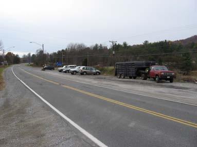
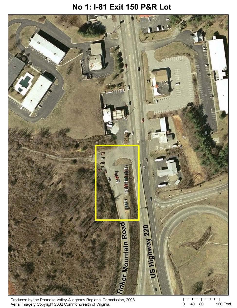
6 Existing Facilities Robert Spillar, (1997) identifies Park-and-Ride lots have a connection to transit and rail systems and Park-and-Pool lots are principally for ridesharing (carpooling and vanpooling). In the study region, only three facilities are Park-and-Ride lots by this definition: the lots at I-81 exits 140 and 118C and the Kmart parking lot in Christiansburg, all of which serve as stops for the Smart Way commuter bus. However, because common usage and existing signage in the area identifies all commuter lots as Park-and-Ride lots and does not distinguish between those with and without transit stops, the term Park-and-Ride is used in reference to both kinds of lots. The Virginia Department of Transportation (VDOT) classifies the Park-and-Ride lots into two categories. Official VDOT Lots are lots owned or leased by VDOT. Unofficial Lots are parking lots that VDOT recognizes as being used for commuter parking, but they are not designed as formal Park-and-Ride lots. A total of 19 lots that exclusively serve car and vanpoolers are located throughout the study area. There are seven (7) facilities along Interstate I-81, four of which are Official VDOT Lots. Along US Highway 460 in Giles County there are five unofficial lots and one official VDOT lot at the intersection with route 808. Also, in Giles County along Route 100 there are two lots, one of them being official. In Floyd County, along Route 8 there is an unofficial lot at the site of a public trash collection area, and in Franklin County off US route 220 there is one Official VDOT Park-and-Ride lot. Figures 2 and 3 identify the location of facilities, and Table 1 summarizes the inventory of the lots. Table 1. Park-and-Ride/Pool lots inventory Map Location 1 2 Name County Location VDOT Category Tinker Creek Mnt Orange Market Botetourt Roanoke 3 Hanging Rock Roanoke 4 I-81 Exit 140 Roanoke I-81 Exit 150 Route 220 & Rte 816 Tinker Mountain Road Route 311 Rte 419, 311, 630 Kessler Mill Road Route 311 Rte 419, 311, 630 Kessler Mill Road I-81 Exit 140 Edge Brook Road 4 Official Unofficial Unofficial Official Classification Park & Pool Park & Pool Park & Pool Park & Ride 5 Rocky Mount Franklin Route 220 & Rte 40 Official Park & Pool 6 I-81 Exit 128 Montgomery I-81 Exit 128 Pedlar Road Official Park & Pool 7 Falling Branch Montgomery I-81 Exit 118C Route 640 Official Park & Ride 8 I-81 Exit 114 Montgomery I-81 Exit 114 Unofficial Park & Pool
7 Map Location Name County Location VDOT Category Classification Route 8 Riner Rd & Flangan Dr 9 Deli Mart Montgomery Route 8 & Moose Dr Unofficial Park & Pool 10 K-Mart Parking lot Montgomery US Highway 460 BUS N Franklin St/Laurel St. Unofficial Park & Ride 11 Newport Giles Spruce Run & US 460 Unofficial Park & Pool 12 US 460 & Rte Mountain Lake Dr & Giles 700 US 460 Unofficial Park & Pool 13 Maybrook Giles Ryan Ln & US 460 Unofficial Park & Pool 14 US 460 & Rte Rose Briar Ln & Giles 808 Camper Rd Official Park & Pool 15 Tallboy Lot Giles US 460 & Rte 61 Not categorized Park & Pool 16 Foodland Giles Route 460 & Rte 219 Not categorized Park & Pool 17 Bane Giles Bane Rd & Route 100 Unofficial Park & Pool 18 Staffordsville Giles Rte 100 & Rte 660 Official Park & Pool 19 Poplar Hill Giles Route 100 & Rte 42 Unoffcial Park & Pool 20 Marathon Rte 177 & Mud Pike Montgomery Mart Rd Unofficial Park & Pool 21 I-81 Exit 94 Pulaski Possum Hollow Rd & Count Pulaski Dr Official Park & Pool 22 I-81 Exit 89 Pulaski Route 100 & Kirby Rd Unofficial Park & Pool 23 Trash Rte 8 & Beaver Creek Floyd Collection Rd. Unofficial Park & Pool 5
8 6
9 Figure 2 7
10 Figure 3 8
11 Performance Measures Connectivity Park-and-Ride facilities provide direct access to transit service. This service is made available to the region through the Smart Way commuter bus. The Smart Way provides service between the Campbell Court transfer station in downtown Roanoke and Squires Student Center on the Virginia Tech campus. A one-way trip ticket is $3.00, and a monthly pass providing unlimited rides is $100. Purchase of a Smart Way ticket or pass provides free transfers onto Valley Metro buses. All the buses are wheelchair lift-equipped. This service offers 12 round trips each weekday between 5:15 am and 6:50 pm, and a special evening service on Fridays and Saturdays at 8:20 pm. The route runs along US highway 460, I-81 corridor and I-581. The Smart Way provides connection to the Roanoke Regional Airport approximately every two hours during its hours of operation. The Smart Way bus serves the regional commuters by proving regular stops at three Park-and-Ride facilities along the corridor, including I-81 Exit 140 official Park-and-Ride, I-81 Exit 118 Falling Branch lot, and K- mart parking lot in Christiansburg. The K-mart parking lot in Christiansburg is also served by Blacksburg Transit s Two-Town Trolley, a bus connecting 18 stops between Christiansburg and the Virginia Tech campus. This route is operated year-round from noon to 6 p.m. seven days a week. Fares are $.50 a ride or $8.00 for a monthly pass; Virginia Tech faculty, staff, and students ride free with ID, and elderly and disabled can ride for half fare. Blacksburg Transit is in the planning stages of expanding service and hours that would affect this Park-and-Ride stop. The remaining lots serve carpoolers. However, higher standards in connectivity can also be achieved when users can access the lot by foot or by bicycle. The Orange Market and Hanging Rock parking lots are accessible by the Hanging Rock Greenway, bicycle racks are available at the Orange Market parking lot, but racks or locking stations should be provided at both ends so users can feel comfortable leaving their bicycles during the day. The Rocky Mount Park-and- Ride on Route 220 South was also observed to have a bicycle parked on premises on several of the surveys. Capacity The occupancy of the parking lots was inventoried four times during the month of November, by the staff of NRVPDC and RVARC. The data was collected during regular working days (Mondays and Fridays) between the hours of 10:00 AM and 2:00 PM. Figures 4 and 5 show the utilization data for the parking lots located in the Roanoke Valley and Alleghany region and the 9

12 New River Valley respectively. Of the lots, two are operating at over capacity (all spaces taken, cars parked on grass areas or shoulders). Five lots are heavily used, between 50% and 80% full, and 12 lots are underused, or at less than 50% occupancy at midday. Usage was determined by averaging the number of vehicles parked in the lot during each of the field surveys. Figure 4: Average Parking Lot Usage RVARC Figure 5: Average Parking Lot Usage NRVPDC 10
13 The existing lots at overflow are located along Interstate I-81 on Exits 150 and 140. These facilities had been analyzed in previous Park-and-Ride studies for the region. By comparing these results with the data from the previous Park-and-Ride studies (2005 and 2003) prepared by the RVARC (Table 2), we found that though the deficit in parking spaces at Exit 150 continues, it has declined by 17 users since 2005, and 10 users since This kind of change in usage requires special attention since it could be a consequence of the inefficiency of the lot, making the users either look for an alternative parking lot or simply changing the carpooling habits. On the other hand, at the Park-and-Ride Exit 140 the usage has increased by 26 in the last 3 years, and by 24 users since These results reflect the popularity of this Park-and- Ride due to the Smart Way service available to the users of the lot. Table 2: Existing Parking Lot Capacity Deficits Location Existing Utilization Utilization 2005 Utilization 2003 Location Existing Existing Existing Average Average Deficit Capacity Use Deficit Usage Usage Deficit I-81 Exit I-81 Exit N/A 50 N/A 11
14 In both cases of capacity deficit, it can be assumed that some opportunity for additional transit ridership or carpool activity is being lost. In the case of Exit 150, it would appear that not only does the lot remain at overcapacity, but user confidence in the availability of the lot had dropped. In either case, the lost opportunity could result in a negative impact on long-term TDM behavior change, since rebuilding the confidence of users will be difficult. The Park-and-Ride location at I-81, Exit 114 was functioning at 37% capacity when surveyed. This represents a moderate use of 12 possible parking spaces. However, all 12 spaces are on the shoulder of Route 8 within 100 yards of the interchange. The site is highly visible and accessible, but the location also poses a safety issue for its users and passing vehicles. Within a quarter mile west of the interchange a vacant lot has turned into an unofficial Park-and-Ride functioning at 58% capacity. This suggests a high motivation to carpool on the part of users at this location. While the remaining Park-and-Ride lots are functioning well within capacity, it should be noted that a number of them are unofficial lots on private property. The Foodland parking lot has been a locally well-known Park-and-Ride lot in Giles County. Signs have recently been posted expressly stating the lots is for customers only. The Tallboy lot, three miles east on Route 460, was not identified in earlier Park-and-Ride studies completed in the New River Valley. The high use of this unofficial Park-and-Ride could be a migration of carpooling commuters using Route 460. The vicinity of each I-81 interchange should be considered for development of official Park-and- Ride facilities. Given the planned I-81 improvements, now is the time to consider/explore these possibilities so that funding for facility development can be programmed into the I-81 projects. Access Way Finding On Interstate I-81 approaching exits 140, 128, 118 and 94, there are Commuter Information signs with the telephone number for the TDM program. Also, signs are found on Route 100 approaching the Staffordsville lot, and on Route 460 approaching Route 808. Park-and-Ride Signs leading to the lots can be found at the following locations only: Lee Highway leading to Tinker Creek Mnt Lot Exit 128 (from Interstate 81 northbound lanes) Exit 94 (from Interstate 81 southbound lanes) Staffordsville (from Route 100 northbound lanes) Bike and Pedestrian Access 12
15 Considering that the majority of Park-and-Ride lots are located along the interstate system, it is unsurprising to find few accessible facilities for pedestrians or bicyclists to the lots. The lot at exit 140 can be accessed by bicycle on Route 311, and other secondary roads. Although bicycle traffic is low, riders on the Smart Way have been observed to bring their bicycles on board the bus particularly on routes coming to Roanoke from Blacksburg and this could indicate an opportunity for more multimodal options. Lots located on route 311, Hanging Rock and Route 419 can be directly accessed from the Hanging Rock Battlefield Greenway trail in Salem. Bicycle racks and other pedestrian and cycling facilities are critical factors in the means of generating new ridership demographics in the area, and should be taken into consideration in the planning of new facilities. Park-and-Ride facilities can be more effective in reducing single-occupant vehicle commuting when designed to accommodate a multimodal share of users. Vehicle Access In general, vehicle access to the parking lots is very good, since they are located along state and national highways. The region of southwest Virginia does not experience many problems with traffic congestion that could turn into travel delays for commuters. However, given the high volume of truck movement along I-81, safety on the road has been a local issue. Carpooling becomes a good alternative to increase security on the roads by reducing congestion and helping drivers to stay more alert when traveling with company. General Conditions The conditions survey covered amenities available, security, lighting, visibility, general activity in the lots and pavement conditions. The observations present information on why the lots may be underused. Most of the lots lack the majority of surveyed amenities such as public phones, benches, shelters, information signs, or even trash receptacles. The unofficial lots associated with convenience stores or retail outlets generally have better accommodations, though the accommodations are associated with the retail building and not the lot itself. Out of the lots, nine (about 40%) are lighted. Since most of the lots are located along the interstate or main highways, their activity rates range between moderate to high in most cases. The pavement condition ranked mostly between poor and bad in all locations; only five (20%) of the parking lots present good pavement conditions. It is important to note that in these cases, the poor rating may be a result of mixed-surface lots; for example, in the cases of I-81 Exit 140, I-81 Exit 150, and Rocky Mount, each of these lots have both paved and graveled surfaces. While the paved surfaces might have been in good condition themselves, the presence and usage of the rutted gravel surfaces brought the entire rating down. Table 3 presents the results for the amenities, condition and security survey of each lot. 13
16 Table 3: General Conditions for Park-and-Ride Lots Name Condition Security Amenities Lot Pavement Lighting Visibility Activity Tinker Creek Mnt 2 information signs Fair Good Bad Fair High Orange Market Lights Fair Bad Poor Good High I-81 Exit Lights - 1 Bus Stop - Information Signs Fair Excellent Good High - Trash Receptacles Rocky Mount 1 Trash Receptacle Good N/A N/A Good Low I-81 Exit light - 1 Information Sign Poor Poor Fair Good Low Falling Branch - 7 lights - 1 Bus Stop with elevated concrete platform Excellent Good Excellent Excellent High - 2 information signs - Bus schedule I-81 Exit 114 None Good Poor Bad Excellent High Deli Mart - Convenience store Good Poor Bad Excellent High K-Mart Pkn lot - 4 lights - 1 Bus stop, sheltered and with benches - Information signs Good Good Excellent Good High (smart way and B/burg Transit) - 1 trash receptacle US 460 & Rte 700 None Fair Poor Bad Excellent Low US 460 & Rte information Sign - 1 trash receptacle Good Poor Bad Excellent Low Tallboy Lot - 1 trash receptacle Fair Poor Bad Excellent High Foodland - 1 Public Phone - 6 Lights Excellent Excellent Excellent Excellent Moderate Bane - 1 Information Sign - 1 trash receptacle - 3 Picnic tables at Excellent Excellent Bad Excellent Low wayside Staffordsville - 1 Information sign Fair Poor Bad Excellent Moderate Marathon Mart - 1 Light - Convenience Store Good Poor Poor Fair High I-81 Exit 94 1 information sign Good Bad Bad Good Moderate I-81 Exit 89 None Fair Bad Bad Excellent Moderate Trash Collection None Good Fair Bad Excellent Moderate 14
17 Education Awareness of existing Park-and-Ride lots can be cultivated through several existing resources. VDOT s internet resources, the local ridesharing program RIDE Solutions, and way finding and commuter information signs along the area s commuting routes can increase use among commuters and residents using Virginia 511 and RIDE Solutions to plan their trips. Way finding signs Way finding signs along the road are an immediate and localized educational tool as much as they are a simple directional sign. Commuters that have found carpooling partners through means outside of RIDE Solutions or that do not know about the internet resources can still find meeting points based on the signs they ve seen on their commutes. The knowledge that a Parkand-Ride exists can be one more barrier removed in a commuter s willingness to try carpooling. The blue Commuter Information signs posted by VDOT throughout the area advertise the RIDE Solutions toll-free number. This is another access point to ridesharing resources and education. Virginia 511 Virginia 511 is a real-time traffic and weather information available to anyone by simply dialing from your phone or via web at Virginia is a service of VDOT. The service gives access to a variety of information by regions throughout the state: Real-time traffic conditions Road conditions and weather Route planning Commuting alternatives Among the commuting options, users can access to an interactive map with all the Park-and- Ride facilities throughout the state, as well as to information about carpooling/vanpooling in your community. RIDE Solutions RIDE Solutions is a regional ridesharing program operated by the Roanoke Valley-Alleghany Regional Commission in cooperation with the New River Valley Planning District Commission. This is a grant-funded program that provides FREE carpool matching services for citizens of the Roanoke and New River Valley regions and surrounding areas within southwestern Virginia. Through Ride Solutions, citizens can find directions to regional Park-and-Ride lots and 15
18 information on alternative modes of transportation. This information is available in printed copies and on the web at 16
19 Recommendations New and Expanded Facilities: I-81 Exit 140 I-81 Exit 140 has been identified as exceeding the capacity of the facility. The growth of usage at Exit 140 would appear to coincide with growing transit use over the course of With that in mind, RIDE Solutions recommends doubling the size of the current Exit 140 lot by paving the existing spillover area. In addition, RIDE Solutions recommends positioning this lot s primary use as a Park-and-Ride for the Smart Way bus through signage and the installation of a solar bus shelter. To meet the needs of carpoolers and limits of the right-of-way at the exiting Exit 140 lot, RIDE Solutions recommends the addition of a second carpool lot, either at Exit 137 in West Salem or Exit 141 at Route 419. A lot at Route 419 would better connect commuters directly to the primary arterial roadway through the Roanoke Valley than the existing connection at Route 311 at Exit 140. In addition, a Park-and-Ride facility at Route 419 could connect to future transit service along the 419 corridor. New and Expanded Facilities: I-81 Exit 150 I-81 Exit 150 has long required expansion, and given the drop in usage numbers over the 2008 survey period compared to both the 2005 and 2003 numbers, there is some concern than the lack of accommodations may have driven potential users away and encouraged them to remain in their SOV mode. Given the state of the existing lot, it appears unlikely that there is sufficient room to expand the lot to the recommended 40 or 50 spaces. VDOT should consider relocating the lot entirely, and perhaps even consider a space-sharing agreement with one of the businesses immediately north of the existing lot. New and Expanded Facilities: I-81 Exit 114 The Park-and-Ride location at I-81, Exit 114 has been identified as a moderately used location, in spite of the apparent safety issues. This, along with the high use of an informal lot on Route 8 just beyond the interchange, indicates a high motivation to carpool on the part of users at this location. The exit 114 interchange area stands out in terms of need for, and potential benefit from, a formal Park-and-Ride facility. If highway construction/improvements are undertaken in the vicinity of exit 114, related to either I-81 or Route 8, efforts should be undertaken to include right-of-way and construction funding for development of a Park-and-Ride facility. 17
20 New and Expanded Facilities: Route 220 at Boones Mill During the gas price spikes of 2008, one of the fastest-growing commuter segments in the RIDE Solutions database were commuters coming from Rocky Mount and the greater Franklin County area into Roanoke. Commuters in Rocky Mount and farther south are well-served by the existing Park and Ride at Routes 220 and 40, but commuters farther north have no such facilities. Further, origin points north of Rocky Mount particularly in the Boones Mill area are much more varied in the rural area, providing no good meeting spot for commuters until commute routes converge in Boones Mill itself. A Park-and-Ride facility in the Boones Mill area would not only service commuters in the immediate vicinity, but would provide a convenient connection to existing carpools coming north from Rocky Mount. RIDE Solutions therefore recommends a new Park-and-Ride facility in the Boones Mill region. There is at least one opportunity for a private-public partnership with the Boones Mill Baptist Church just south of the town proper; the lot, with direct access to Route 220, was seen to be largely unused during the day on each of the field work visits to the Rocky Mount lot, and appears to have more than sufficient space to meet existing demand. Barring that, a 50-space lot should be considered by VDOT. In the latter case, VDOT should also consider building a bus shelter, as there is commuter bus service between Roanoke and Rocky Mount, and Boones Mill would likely be one of a very few stops along the route. General Conditions There are some general improvements that could be made at each of the lots: More frequent emptying of trash receptacles and the addition of recycling bins to each lot. Trash can cause a nuisance when not properly disposed of or permitted to accumulate. Where trash receptacles do exist, better maintenance and frequent trash removal is needed. The addition of trash receptacles and recycling bins at lots currently without them would alleviate the nuisance and improve the appearance of the lot. A lot s appearance can also impact the user s sense of security at a lot. VDOT should also consider working with the localities to add recycling drop-offs at each of its lots, both to provide users who may not have recycling in their localities access to a convenient drop-off location, and to make the lots productive for noncommute-time usage. Bicycle racks and other facilities are recommended in these lots to encourage more ridership. This is a critical factor in the means of generating new ridership demographics in the area, and should be taken into consideration in the planning of new facilities. Future Park-and-Ride facilities should be designed to accommodate a multimodal share of users. Where connectivity to greenways and other alternative accommodations are feasible they should be implemented; the Route 311 Park-and-Ride serves as a sterling example of multimodal connectivity. 18
21 An information kiosk or other accommodation, not unlike those found at rest stops, should be considered. RIDE Solutions could take on the maintenance of such kiosks. It is entirely possible that users of Park-and-Rides are not aware of existing transportation demand management programs and, if encouraged to participate, might reduce demand to the Park-and-Ride by finding carpool partners closer to home. The ratio of official to unofficial lots in the New River Valley is high. Given that so many of those unofficial lots are on private property, future studies should evaluate the need to create formal agreements with existing lot owners to ensure continued availability of the facilities or creating official VDOT facilities where feasible. Way finding Way finding signs serve a dual purpose. They direct users to the Park-and-Ride location and they promote the presence of the facility to commuters. Given the informal nature of most Park-and-Ride lots in the region, installing Park-and-Ride signs at key intersections and along corridors approaching these facilities would educate commuters to the availability of accessible locations from which to switch their commute mode to a higher-occupancy vehicle. Lots with the highest usage, excepting those served by the Smart Way bus, are those with a high degree of visibility from the travel corridor (such as Exit 150, Orange Market on Route 311, Rocky Mount off US Route 220, the Tallboy lot on Route 460, Exit 94, Route 8 s two locations, the Floyd trash collection site, and the Marathon Mart on Route 177). Signage directing commuters to a less visible, but still easily accessible lot could reasonably increase a lot s usage. References - Spillar, Robert J P.E. A comprehensive Planning and Design Manual for Park-and-Ride Facilities William Barclay Parsons Fellowship. Parsons Brinckerboff. Monograph 11. New York. October, Darby, Mary A. Ride Solutions Study. Department of Urban Affairs and Planning- Virginia Tech. Blacksburg Dokken Engineering. Park-and-Ride Facilities Master Plan. El Dorado County Transit Authority. November 14, Cape Cod Commission Transportation Staff. Cape Cod Park-and-Ride Study. County of Barnstable, Massachusetts. November Roanoke Valley-Alleghany Regional Commission. Ride Solutions Park-and-Ride Study. Roanoke, VA. April Roanoke Valley-Alleghany Regional Commission. Present VDOT Park-and-Ride Lot Capacity in RVARC Region Roanoke, VA. July
22 20

23 Appendix 1: Sample Park-and-Ride Lot Inventory Form 21
24 22


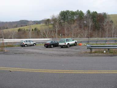
25 Appendix 2: Photograph inventory of Park-and-Ride Lots #1 Tinker Creek Mountain #2 Orange Market # Exit 140 #5 Rocky Mount # 6 I-81 Exit 128 #7 Falling Branch 23


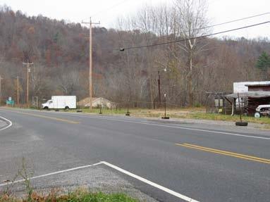
26 #8 I-81 Exit 114 #9 Deli Mart # 10 K-Mart Parking Lot #12 US 460 & Rte 700 #14 US 460 & Rte 808 #15 Tallboy Lot 24


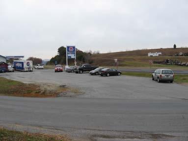
27 #16 Foodland # 17 Bane # 18 Staffordville #19 Poplar Hill #20 Marathon Mart #21 I-81 Exit 94 25

28 #22 I-81 Exit 89 26
29 Appendix 3: Aerial photographs of Park-and-Ride Lots 27
30 28
31 Once this document is convert to a PDF, please remove this page and add the PDF files of the Aerial photos. Thank you 29
EMPLOYMENT MOBILITY. VDOT Multimodal Planning Grant: January prepared for Virginia Department of Transportation
 VDOT Multimodal Planning Grant: EMPLOYMENT MOBILITY January 2009 prepared for Virginia Department of Transportation prepared by New River Valley Planning District Commission in cooperation with the U.S.
Arlington County Board Meeting Project Briefing. October 20, 2015
 Arlington County Board Meeting Project Briefing October 20, 2015 Project Map 2 Project Context Only Interstate in the Country limited to HOV only traffic during rush hours Stoplight at the end of I-66
Public Information Meetings. October 5, 6, 7, and 15, 2015
 Public Information Meetings October 5, 6, 7, and 15, 2015 Project Map 2 Project Context Only Interstate in the Country limited to HOV only traffic during rush hours Stoplight at the end of I-66 eastbound
Multimodal Planning Studies
 Multimodal Planning Studies Commuter Park and Ride Study Steering Committee Meeting June 6, 2013 Agenda 1. Update on Project Schedule 2. Update on Online Interactive Mapping 3. Key Themes from the Open
City of Durango 5.8 FUNDING TRAILS DEVELOPMENT
 5.8 FUNDING TRAILS DEVELOPMENT The City has been successful in establishing dedicated local funding sources as well as applying for grants to develop the City s trail system, having received nearly $2.4
Word Count: 3,565 Number of Tables: 4 Number of Figures: 6 Number of Photographs: 0. Word Limit: 7,500 Tables/Figures Word Count = 2,250
 Katherine F. Turnbull, Ken Buckeye, Nick Thompson 1 Corresponding Author Katherine F. Turnbull Executive Associate Director Texas Transportation Institute Texas A&M University System 3135 TAMU College
McLean Citizens Association Transportation Committee Project Briefing
 McLean Citizens Association Transportation Committee Project Briefing November 10, 2015 Project Map 2 Project Context Only Interstate in the Country limited to HOV only traffic during rush hours Stoplight
DISTRICT EXPRESS LANES ANNUAL REPORT FISCAL YEAR 2017 JULY 1, 2016 JUNE 30, FloridaExpressLanes.com
 DISTRICT EXPRESS LANES ANNUAL REPORT FISCAL YEAR 2017 JULY 1, 2016 JUNE 30, 2017 FloridaExpressLanes.com This page intentionally left blank. TABLE OF CONTENTS List of Figures... ii List of Tables.... ii
TRANSPORTATION ELEMENT
 Transportation TRANSPORTATION ELEMENT Data, Inventory, and Analysis Prepared by Contents 1.0 INTRODUCTION... 1 2.0 EXISTING CONDITIONS... 1 2.1 Roadways... 1 2.1.1 Jurisdiction... 1 2.1.2 Functional Classification...
New River Valley s Regional Transit Coordinating Council December 15, :00 p.m.
 New River Valley s Regional Transit Coordinating Council December 15, 2015 3:00 p.m. Meeting Agenda Welcome and Introductions Local Project Updates/Announcements Roundtable Discussion Adjournment Transit
FOR IMMEDIATE RELEASE February 22, 2019 CONTACT: Jen K. Ward, SALEM 69
 FOR IMMEDIATE RELEASE February 22, 2019 CONTACT: Jen K. Ward, 540-387-5238 SALEM 69 Jen.Ward@vdot.virginia.gov - The following is a list of forecasted highway projects that may impact traffic traveling
Other Principle Arterials Minor Arterial Major Collector Minor Collector Local
 CHAPTER 10 TRANSPORTATION Introduction The system of public roads in East Pikeland Township is decidedly rural in character. Since the 1984, the road network has remained much the same, with the addition
Georgetown-Lewes Rail/Trail Study. Rail/Trail Study: Cool Spring to Cape Henlopen State Park New Road Extension (House Resolution No.
 Georgetown-Lewes Rail/Trail Study Rail/Trail Study: Cool Spring to Cape Henlopen State Park New Road Extension (House Resolution No. 47) August 22, 2011 Presentation Outline Background Benefits Statewide
RELATED SANTA CLARA SANTA CLARA, CALIFORNIA. RELATED SANTA CLARA Santa Clara, CA
 RELATED SANTA CLARA SANTA CLARA, CALIFORNIA RELATED SANTA CLARA Santa Clara, CA JUNE 2016 APPROVAL TIMELINE RELATED SANTA CLARA Santa Clara, CA 1 ACRES PARKS & OPEN SPACE (40% OF TOTAL SITE) PARCEL 3 PARK
Appendix 4.1 J. May 17, 2010 Memorandum from CTPS to the Inter Agency Coordinating Group
 Appendix 4.1 J May 17, 2010 Memorandum from CTPS to the Inter Agency Coordinating Group CTPS CENTRAL TRANSPORTATION PLANNING STAFF Staff to the Boston Region Metropolitan Planning Organization MEMORANDUM
Madison Metro Transit System
 Madison Metro Transit System 1101 East Washington Avenue Madison, Wisconsin, 53703 Administrative Office: 608 266 4904 Fax: 608 267 8778 TO: FROM: SUBJECT: Plan Commission Timothy Sobota, Transit Planner,
Understanding Your I-66 Trip
 Understanding Your I-66 Trip DETERMINING YOUR TRIP Identify the location of your most convenient entrance and then follow the map to your exit. Pricing is tracked by four gantries along the corridor. Traffic
Public Transit Services on NH 120 Claremont - Lebanon
 Public Transit Services on NH 120 Claremont - Lebanon Overview of Preferred Alternative April 12, 2011 Presentation Overview Study Goals Quick Review Methodology and Approach Key Findings Results of Public
AGENDA. September 1, 2016 MEMORANDUM. Members, Transportation Technical Committee. Mark McCaskill, AICP, Director of TPO Programs
 313 Luck Avenue, SW Roanoke, Virginia 24016 P: 540.343.4417 / F: 540.343.4416 rvtpo.org September 1, 2016 MEMORANDUM TO: FROM: SUBJ: Members, Transportation Technical Committee Mark McCaskill, AICP, Director
Construction underway. STATUS: 229 5,190 5,419 5,305 STIP REFERENCE #FR /01/2013
 FREDERICK COUNTY STATE HIGHWAY ADMINISTRATION -- Frederick County -- Line 1 PROJECT: I-7, Baltimore National Pike INTERSTATE CONSTRUCTION PROGRAM DESCRIPTION: Widen I-7 east of MD 355 to east of MD 144
5.1 Traffic and Transportation
 5.1 When it opens in 2009, the Bellevue Nickel Improvement Project will increase the number of vehicles able to travel through the study area, improve travel speeds, and improve safety by reducing the
Trail Use in the N.C. Museum of Art Park:
 Trail Use in the N.C. Museum of Art Park: New Connections, New Visitors Jacqueline MacDonald Gibson, PhD Daniel Rodriguez, PhD Taylor Dennerlein, MSEE, MCRP, EIT Jill Mead, MPH Evan Comen University of
Chapter 6: POLICY AND PROCEDURE RECOMMENDATIONS
 Chapter 6 POLICY AND PROCEDURE RECOMMENDATIONS FOR SRRA Below are seven policy elements that should be considered for adoption by the Southwest Regional Recreation Authority of Virginia: 1. Develop strategies
Blueways: Rivers, lakes, or streams with public access for recreation that includes fishing, nature observation, and opportunities for boating.
 Parks, Open Space and Trails PRINCE WILLIAM COUNTY 2008 COMPREHENSIVE PLAN TRAILS PLAN CONTENTS The components of the trails plan are: Intent Definitions Goals, Policies, and Action Strategies Trails Map
3. Proposed Midwest Regional Rail System
 3. Proposed Midwest Regional Rail System 3.1 Introduction The proposed Midwest Regional Rail System (MWRRS) will operate in nine states, encompass approximately 3,000 route miles and operate on eight corridors.
6 HIGH-OCCUPANCY-VEHICLE (HOV) LANES AND TRAVEL DEMAND MANAGEMENT (TDM) PROGRAMS
 LANES AND TRAVEL DEMAND MANAGEMENT (TDM) PROGRAMS") 6 HIGH-OCCUPANCY-VEHICLE (HOV) LANES AND TRAVEL DEMAND MANAGEMENT (TDM) PROGRAMS Travel demand management (TDM) programs enable roadways, which have a fixed capacity, to accommodate more travelers without
6 HIGH-OCCUPANCY-VEHICLE (HOV) LANES AND TRAVEL DEMAND MANAGEMENT (TDM) PROGRAMS Travel demand management (TDM) programs enable roadways, which have a fixed capacity, to accommodate more travelers without
Ridership Growth Strategy (RGS) Status Update
 Status Update") For Information Ridership Growth Strategy (RGS) Status Update Date: July 10, 2018 To: TTC Board From: Deputy Chief Executive Officer Summary The TTC s Ridership Growth Strategy (RGS), with all its components,
For Information Ridership Growth Strategy (RGS) Status Update Date: July 10, 2018 To: TTC Board From: Deputy Chief Executive Officer Summary The TTC s Ridership Growth Strategy (RGS), with all its components,
Longmont to Boulder Regional Trail Jay Road Connection DRAFT FINAL REPORT
 Longmont to Boulder Regional Trail Jay Road Connection DRAFT FINAL REPORT December 2018 Project Summary Boulder County, Colorado, in partnership with the City of Boulder, is evaluating options for multi-use
SAMTRANS TITLE VI STANDARDS AND POLICIES
 SAMTRANS TITLE VI STANDARDS AND POLICIES Adopted March 13, 2013 Federal Title VI requirements of the Civil Rights Act of 1964 were recently updated by the Federal Transit Administration (FTA) and now require
Nashua Regional Planning Commission
 Nashua Regional Planning Commission Congestion Management Program Corridor Overview NH 111 is a major east-west arterial roadway that passes through 3 municipalities in the Nashua region. It enters the
A. CONCLUSIONS OF THE FGEIS
 Chapter 11: Traffic and Parking A. CONCLUSIONS OF THE FGEIS The FGEIS found that the Approved Plan will generate a substantial volume of vehicular and pedestrian activity, including an estimated 1,300
APPENDIX B COMMUTER BUS FAREBOX POLICY PEER REVIEW
 APPENDIX B COMMUTER BUS FAREBOX POLICY PEER REVIEW APPENDIX B COMMUTER BUS FAREBOX POLICY PEER REVIEW The following pages are excerpts from a DRAFT-version Fare Analysis report conducted by Nelson\Nygaard
Metro ExpressLanes April 5, 2011 Community Meeting re: Adams Blvd Improvements
 Metro ExpressLanes April 5, 2011 Community Meeting re: Adams Blvd Improvements Jan Perry Councilwoman, District 9 Welcome Remarks Arthur T. Leahy Chief Executive Officer, Metro Metro ExpressLanes Overview
WESTERN EL DORADO COUNTY SHORT AND LONG-RANGE TRANSIT PLAN Executive Summary
 WESTERN EL DORADO COUNTY SHORT AND LONG-RANGE TRANSIT PLAN Executive Summary Prepared for the El Dorado County Transportation Commission Prepared by The El Dorado County Transportation Commission (EDCTC)
Transportation Demand Management Plan for the Proposed Hampton Inn & Suites in San Mateo, California
 Memorandum Date: October 3, 207 To: From: Subject: Tricia Schimpp, City of San Mateo Gary Black Ricky Williams Transportation Demand Management Plan for the Proposed Hampton Inn & Suites in San Mateo,
Smart Commute Action Plan for The Middle School
 Smart Commute Action Plan for The Middle School 2014 Smart Commute Plan for the Middle School 1 Staff Survey Summary Smart Commute Action Plan for the Middle School The Middle School gave its first Smart
Interstate 90 and Mercer Island Mobility Study APRIL Commissioned by. Prepared by
 Interstate 90 and Mercer Island Mobility Study APRIL 2017 Commissioned by Prepared by Interstate 90 and Mercer Island Mobility Study Commissioned by: Sound Transit Prepared by: April 2017 Contents Section
MEMORANDUM. for HOV Monitoring on I-93 North and the Southeast Expressway, Boston Region MPO, November, 2011.
 MEMORANDUM Date: January 12, 2012 To: Congestion Management Process Files From: Seth Asante, Ryan Hicks, and Efi Pagitsas MPO Staff Re: Historical Trends: Travel Times and Vehicle Occupancy Levels for
Revolutionary Mobility
 Northern Virginia Real-time Ridesharing i Pilot Jason M. Conley Director of Government Relations Avego Corporation HRTO February 14, 2012 Revolutionary Mobility Road Map Real-time Ridesharing Overview
Pedestrian Safety Review Spadina Avenue
 STAFF REPORT ACTION REQUIRED Pedestrian Safety Review Spadina Avenue Date: October 13, 2015 To: Toronto and East York Community Council From: Director, Transportation Services, Toronto and East York District
EXISTING CONDITIONS A. INTRODUCTION. Route 107 Corridor Study Report
 II. EXISTING CONDITIONS A. INTRODUCTION The Route 107 study area extends from the south at Chestnut Street in Lynn approximately 3.7 miles to the north to Boston Street in Salem. The study area has three
TRAFFIC ALERT FOR DECEMBER 25, 2017 to JANUARY 5, 2018 Highway Work Zones in the Staunton District
 RELEASE: IMMEDIATE December 21, 2017 CONTACT: Sandy Myers 540-332-9201 (office) STA17-204 540-292-2500 (cell) Sandy.Myers@VDOT.virginia.gov Ken Slack 540-332-9264 (office) 540-414-5670 (cell) Ken.Slack@VDOT.virginia.gov
TBARTA: 2015 Master Plan and Tampa Bay Express Project
 TBARTA: 2015 Master Plan and Tampa Bay Express Project The Real Story Who: Tampa Bay Area Regional Transportation Authority What: Develop and implement a Regional Transportation Master Plan for the seven-county
Lake Erie Commerce Center Traffic Analysis
 LOCATION: East of NYS Route 5 at Bayview Road Town of Hamburg Erie County, New York PREPARED BY: Wendel Companies 140 John James Audubon Parkway Suite 200 Amherst, New York 14228 January 2012 i ii Table
TransAction Overview. Introduction. Vision. NVTA Jurisdictions
 Introduction Vision NVTA Jurisdictions In the 21 st century, Northern Virginia will develop and sustain a multimodal transportation system that enhances quality of life and supports economic growth. Investments
Our Panelists SPEAKERS MODERATOR
 SPEAKERS Our Panelists Jennifer Aument, Transurban Gary Garczynski, Commonwealth Transportation Board Russ Gestl, Buchanan Partners, LLC Robert Shue, JLL MODERATOR David Birtwistle, Northern Virginia Transportation
MPRB: Southwest LRT Community Advisory Committee Issues and Outcomes by Location Current to: 12 November 2010
 MPRB: Southwest LRT Community Advisory Committee Issues and Outcomes by Location Current to: 12 November 2010 This is a compilation of issues and outcomes identified by the CAC. It is a work in progress,
Frequently Asked Questions on the Route 29 Solutions Improvements Projects
 Frequently Asked Questions on the Route 29 Solutions Improvements Projects Background What are the Route 29 Solutions improvement projects? These projects include the Route 29/250 Interchange ( Best Buy
Chapter 2 Route window W25 Maidenhead station. Transport for London
 Chapter 2 Route window W25 Maidenhead station MAIDENHEAD STATION 2 Route window W25 Maidenhead station 2.6 The drawings provided at the end of this chapter present the main features of the route window,
EXECUTIVE DIRECTOR. The Potomac Rappahannock Transportation Commission is seeking an ABOUT THE ORGANIZATION
 The Potomac Rappahannock Transportation Commission is seeking an EXECUTIVE DIRECTOR ABOUT THE ORGANIZATION The Potomac Rappahannock Transportation Commission (PRTC) is a multi-jurisdictional agency that
Roanoke County Center for Research and Technology PICTURE YOUR BUSINESS HERE. Roanoke, Virginia USA
 Roanoke County Center for Research and Technology PICTURE YOUR BUSINESS HERE Roanoke, Virginia USA WHERE YOU WANT TO BE As a place to live or make a living, the Roanoke, Virginia USA region is recognized
University Region Non-Motorized Plan 2015
 Non-Motorized Transportation Non-motorized facilities are important components to the transportation system. They provide an environmentally-friendly, low-cost mode of travel. Some of the facilities can
8 CROSS-BOUNDARY AGREEMENT WITH BRAMPTON TRANSIT
 8 CROSS-BOUNDARY AGREEMENT WITH BRAMPTON TRANSIT The Transportation Services Committee recommends the adoption of the recommendations contained in the following report dated May 27, 2010, from the Commissioner
TABLE OF CONTENTS. Coral Springs Charter High School and Middle School Job No Page 2
 Job No. 15-019 Page 2 TABLE OF CONTENTS 1.0 INTRODUCTION... 4 2.0 EXISTING CONDITIONS... 5 3.0 TRAFFIC GENERATION... 7 4.0 TRIP DISTRIBUTION... 8 5.0 FUTURE CONDITIONS... 8 6.0 SITE ACCESS...13 7.0 CONCLUSION...13
Assessment of Travel Trends
 I - 2 0 E A S T T R A N S I T I N I T I A T I V E Assessment of Travel Trends Prepared for: Metropolitan Atlanta Rapid Transit Authority Prepared by: AECOM/JJG Joint Venture Atlanta, GA October 2011 General
STEP ALTERNATIVES RANKING TABLE
 ALTERNATIVES RANKING TABLE Priority Ranking 0 = Lowest Priority 1 2 3 4 5 = Highest Priority Abbreviations TD = Transportation Disadvantaged PWD = People with Disabilities I. Existing Enhancements Increase
Assessing Your Trails, Keeping Them Safe and Enjoyable
 Jon Wood, PLA, ASLA Associate Vice President Stewart Bert Lynn, PLA, ASLA, LEED AP Project Manager Mecklenburg County Asset and Facility Management Assessing Your Trails, Keeping Them Safe and Enjoyable
HOV LANE PERFORMANCE MONITORING: 2000 REPORT EXECUTIVE SUMMARY
 Final Report Research Project Agreement No. T1803, Task 4 HOV Monitoring V HOV LANE PERFORMANCE MONITORING: 2000 REPORT EXECUTIVE SUMMARY by Jennifer Nee TRAC Research Engineer John Ishimaru TRAC Senior
Route 29 Business Replacing bridge over river and railroad in Altavista. Signed detour in place.
 EASTER 2019 VDOT will lift most lane closures for holiday travel from noon Friday, April 19 until noon Tuesday, April 23. However, motorists may encounter semi-permanent work zones or travel delays in
Like many transit service providers, the Port Authority of Allegheny County (Port Authority) uses a set of service level guidelines to determine
 uses a set of service level guidelines to determine") Transit service consists of two fundamental elements: frequency (how often service operates) and service span (how long service runs during the day). Combined, these two factors measure how much service
Transit service consists of two fundamental elements: frequency (how often service operates) and service span (how long service runs during the day). Combined, these two factors measure how much service
Score. Category. Access Aesthetics Community Resources
 NO BUILD ALTERNATIVE The No Build Alternative is the do nothing option that is used for comparison to the build alternatives. The screening assumes no new facilities are constructed as part of the I-93
Elected Officials and Media Briefing I-395 Express Lanes Northern Extension
 Elected Officials and Media Briefing I-395 Express Lanes Northern Extension Updates on: I-95 Express Lanes Southern Extension Transform 66: Inside and Outside the Beltway March 31, 2016 Today s Agenda
FIRST WEEK UPDATE: 66 EXPRESS LANES INSIDE THE BELTWAY Data from first four days shows faster, more reliable trips on I-66
 FOR IMMEDIATE RELEASE Tuesday, December 12, 2017 CONTACT: Michelle T. Holland 703-586-0487 (C) Michelle.Holland@vdot.virginia.gov Jennifer McCord 571-230-2926 Jennifer.McCord@vdot.virginia.gov FIRST WEEK
Estimating Tourism Expenditures for the Burlington Waterfront Path and the Island Line Trail
 A report by the University of Vermont Transportation Research Center Estimating Tourism Expenditures for the Burlington Waterfront Path and the Island Line Trail Report # 10-003 February 2010 Estimating
Table of Contents. List of Tables
 Table of Contents 1. Introduction... 1 2. Service Recommendations... 1 A. Extend Service on Fort Belvoir to New Post Exchange/Commissary Complex... 1 B. Improve Service Frequencies on Sunday from Current
FIRST WEEK UPDATE: 66 EXPRESS LANES INSIDE THE BELTWAY Data from first four days shows faster, more reliable trips on I-66
 Subject: FIRST WEEK UPDATE: 66 EXPRESS LANES INSIDE THE BELTWAY From: VDOT-News To: Time: Tuesday, December 12, 2017 9:05:36 AM -08:00 RELEASE: IMMEDIATE Michelle Holland,
FINCH HYDRO CORRIDOR TRAIL PROJECT
 FINCH HYDRO CORRIDOR TRAIL PROJECT Pharmacy Avenue to Birchmount Road January 29 th, 2018 L Amoreaux Community Centre (2000 McNicoll Avenue) 1 Purpose of Drop In Event The purpose of today s drop-in event
Research Report Agreement T4118, Task 24 HOV Action Plan HOV ACTION PLAN
 Research Report Agreement T4118, Task 24 HOV Action Plan HOV ACTION PLAN by John M. Ishimaru Senior Research Engineer Duane Wright Systems Analyst Programmer Mark E. Hallenbeck Director Jaime Kang Research
FEASIBILITY CRITERIA
 This chapter describes the methodology and criteria used to evaluate the feasibility of developing trails throughout the study areas. Land availability, habitat sensitivity, roadway crossings and on-street
Regional Wayfinding Sign Strategy Thurston County Trails 2017
 Regional Wayfinding Sign Strategy Thurston County Trails 2017 Partners: Members and partnering organizations of the Thurston Thrives Community Design Action Team City of Lacey, City of Olympia, City of
Non-Motorized Transportation
 Non-Motorized Transportation Non-motorized facilities are important components to the transportation system. They provide an environmentally-friendly, low-cost mode of travel. Some of the facilities can
UK Experience with Bus Restructuring
 UK Experience with Bus Restructuring Outline 1. Background 2. Bus Deregulation outside London 3. London strategy 4. Results to date 5. Edinburgh Case Study 1 Background Prior to mid-1980s, UK local bus
Update on the I-680 Transit Corridor Improvement Project HOV on/off Ramps Environmental Impact Report Community Engagement Plan
 Update on the I-680 Transit Corridor Improvement Project HOV on/off Ramps Environmental Impact Report Community Engagement Plan Presentation Overview Introductions Susan Miller, Director of Projects, Contra
4. Proposed Transit Improvements
 4. Proposed Transit Improvements The following proposed transit improvements have been assembled based on input received from the community meetings and from review and coordination with the TAC as well
Transportation Supporting Dulles Airport
 Transportation Supporting Dulles Airport Committee for Dulles Economic Development and Transportation Committee July 12, 2018 Tom Biesiadny, Director Fairfax County Multiple Transportation Improvements
7272 WISCONSIN AVENUE LOCAL AREA TRANSPORTATION REVIEW
 7272 LOCAL AREA TRANSPORTATION REVIEW AND TRANSPORTATION POLICY AREA REVIEW MONTGOMERY COUNTY, MARYLAND Submitted on behalf of Carr Properties Prepared by: Wells + Associates, Inc. Submission: July 1,
Route 29 Solutions Projects
 Your guide to the Route 29 Solutions Projects For full details & continued engagement please visit www.route29solutions.org The Route 29 Solutions Package is a $230 million investment into the improvement
I-66 Inside the Beltway Feasibility Study
 I-66 Inside the Beltway Feasibility Study Feasibility Study Study Process Context Sensitive Dialogues Corridor Assessments / Data Collection Problem Statement Refinement Concept Development Concept Evaluation
Appendix 3. Greenway Design Standards. The Whitemarsh Township Greenway Plan
 Appendix 3 Greenway Design Standards This chapter discusses two design standards for the greenway types discussed above. First, trail design standards are presented together with trailhead facilities and
Appendix 4.1 L. No-Build Project Descriptions
 Appendix 4.1 L No-Build Project Descriptions No-Build Projects New Bedford A new traffic signal system was installed and activated in early 2009 at the intersection of King s Highway and Mount Pleasant
Basic Project Information
 FY 2015-16 PROJECT DESCRIPTION FORM (2C) Submitting Agency: Loudoun County Basic Project Information Project Title: Loudoun County Parkway (VA Route 607) U.S. 50 to Creighton Rd. (2C) Project Type (check
Transit System Performance Update
 Clause 5 in Report No. 4 of Committee of the Whole was adopted, without amendment, by the Council of The Regional Municipality of York at its meeting held on March 29, 2018. 5 2017 Transit System Performance
V. DATA COLLECTION PROGRAM
 V. DATA COLLECTION PROGRAM As discussed in Section IV, an extensive data assembly and data collection program was undertaken to develop the data necessary to calibrate the existing Portway Extensions model
Analysis of Transit Fare Evasion in the Rose Quarter
 Analysis of Transit Fare Evasion in the Rose Quarter Shimon A. Israel James G. Strathman February 2002 Center for Urban Studies College of Urban and Public Affairs Portland State University Portland, OR
Design Public Hearing
 Design Public Hearing Monday, March 7, 2016 Washington-Lee High School Cafeteria 1301 N. Stafford Street, Arlington, VA 22201 Tuesday, March 8, 2016 Eagle Ridge Middle School Cafeteria 42901 Waxpool Road,
City of Murfreesboro. Transit Service and Management Alternatives
 City of Murfreesboro Transit Service and Management Alternatives May, 2005 Table of Contents 1. Introduction... 1 2. Transit Needs... 2 2.1 Demographics...2 2.2 Existing Transit Services...2 2.3 Focus
CONGESTION REPORT 1 st Quarter 2018
 CONGESTION REPORT 1 st Quarter 2018 A quarterly update of the National Capital Region s traffic congestion, travel time reliability, top-10 bottlenecks and featured spotlight Feburary 11, 2019 ABOUT TPB
M E S T I Z O C U R T I S P A R K
 ARAPAHOE CONNECTION TO BUS ROUTE AT ND AND LAWRENCE, FUTURE LIGHT RAIL STATION LEGEND SOCIAL TRAIL FLAGSTONE PAVING TO RESTORE/MAINTAIN CONCRETE PAVING DIAGONAL CURVILINEAR SOCIAL ROUTE IS OUT OF HISTORIC
STA MOVING FORWARD A plan for more and better transit services
 STA MOVING FORWARD A plan for more and better transit services More options. More often. Better transit. Approved by the STA Board of Directors in Resolution 727-14 on December 18, 2014. Revised by the
Waukee Trailhead Public Art and Amenities Project
 Waukee - Trailhead Public Art and Amenities Project Sponsor Waukee Project Title Waukee Trailhead Public Art and Amenities Project Termini Description ( i.e. Park Avenue to 19th Street) NE Intersection
DEMOGRAPHICS AND EXISTING SERVICE
 EXECUTIVE SUMMARY The Central Corridor light-rail transit (LRT) project will open in 2014 and operate between downtown Minneapolis and downtown St. Paul, serving the University of Minnesota and University
2017 TBARTA Future Regional Priority Projects Adopted by TBARTA Board, December 9, 2016
 2017 TBARTA Future Regional Priority Projects Adopted by TBARTA Board, December 9, 2016 Project numbers do not signify ranking they are for mapping identification purposes only. 1. 15th Street East The
Report to the Strategic Development Committee
 Report to the Strategic Development Committee Request of Virginia Department of Transportation for Easements across Washington Dulles International Airport Property at Route 28 May 2016 PURPOSE Staff requests
AGENCY NAME TRANSPORTATION
 TRANSPORTATION TRANSPORTATION AGENCY NAME Prince William County FY 2015 BUDGET CIP-TRANSPORTATION 561 Fuller Road/Fuller Heights Road Improvements Total Project Cost - $4.4 M This project will widen Fuller
AGENDA ITEM 5 D WAKULLA ENVIRONMENTAL INSTITUTE (WEI) TRAIL FEASIBILITY STUDY
 TRAIL FEASIBILITY STUDY") March 19, 2018 AGENDA ITEM 5 D WAKULLA ENVIRONMENTAL INSTITUTE (WEI) TRAIL FEASIBILITY STUDY TYPE OF ITEM: Action STATEMENT OF ISSUE The Wakulla Environmental Institute (WEI) Trail is one of several trails
March 19, 2018 AGENDA ITEM 5 D WAKULLA ENVIRONMENTAL INSTITUTE (WEI) TRAIL FEASIBILITY STUDY TYPE OF ITEM: Action STATEMENT OF ISSUE The Wakulla Environmental Institute (WEI) Trail is one of several trails
The implementation of this Master Plan will be undertaken in logical stages to meet passenger and workforce demands.
 The implementation of this Master Plan will be undertaken in logical stages to meet passenger and workforce demands. Connecting People Building Opportunities 198 Brisbane Airport Corporation CHAPTER 10
IL 390 Station. Wood Dale Open House Summary 5/18/17
 Wood Dale Open House Summary 5/18/17 The first public open house for the Wood Dale Comprehensive Plan took place on May 18 th, 2017. The program was conducted as a fun community event and there were 216
Camping (Primitive) Camping (RV) Electrical Potable Water Grill Established Fire Pit Picnic Table
 Camping (RV) Electrical Potable Water Grill Established Fire Pit Picnic Table") Alden - 9th Road River Mile 777 Map: 38.20833, -98.32031 Managing Agency: Kansas Department of Wildlife, Parks & Tourism Nearest Community: Alden, Rice County Kansas Developed Amenities Provided Parking
Alden - 9th Road River Mile 777 Map: 38.20833, -98.32031 Managing Agency: Kansas Department of Wildlife, Parks & Tourism Nearest Community: Alden, Rice County Kansas Developed Amenities Provided Parking
2008 DEKALB COUNTY TRANSPORTATION PLAN (UPDATE)
") 2008 DEKALB COUNTY TRANSPORTATION PLAN (UPDATE) TABLE OF CONTENTS Introduction 1 Transportation Planning Activities 2 Identification of Problem Areas and Recommended Solutions 7 DeKalb County Projects
2008 DEKALB COUNTY TRANSPORTATION PLAN (UPDATE) TABLE OF CONTENTS Introduction 1 Transportation Planning Activities 2 Identification of Problem Areas and Recommended Solutions 7 DeKalb County Projects
I-95/395 HOV/Bus/HOT Lanes Project Overview
 I-95/395 HOV/Bus/HOT Lanes Project Overview 2 I-95/395 HOV/Bus/HOT Lanes Meetings Agenda 7 p.m. to 9 p.m. Open House Information Stations and Q&A With Project Staff 7:30 p.m. and 8:30 p.m. Project Overview