SECTION 3: PROJECT DESCRIPTION
|
|
|
- Wilfrid Heath
- 6 years ago
- Views:
Transcription
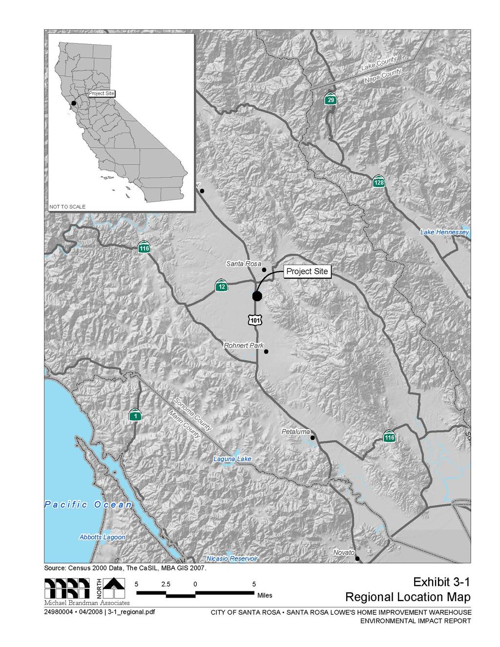
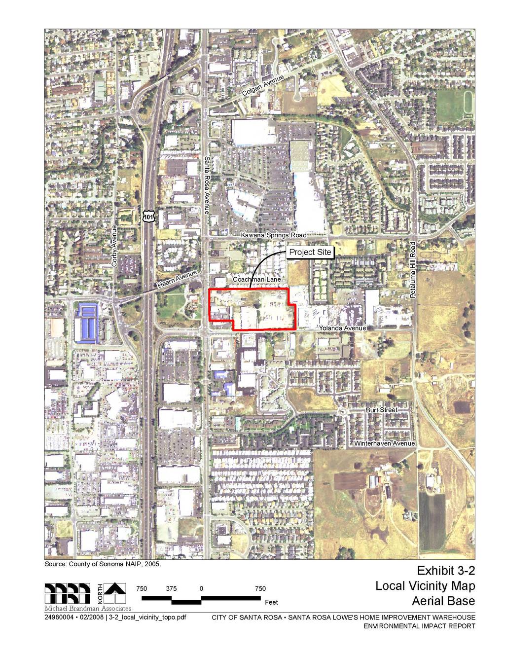
1 Santa Rosa Lowe s Home Improvement Warehouse Project Draft EIR Project Description SECTION 3: PROJECT DESCRIPTION This Environmental Impact Report (EIR) analyzes the potential environmental effects of the proposed Santa Rosa Lowe s Home Improvement Warehouse Project in Santa Rosa, California Project Location and Setting Location The project site is located in the City of Santa Rosa, Sonoma County, California (Exhibit 3-1). The semi-rectangular project site consists of four parcels totaling acres, located at the northeastern quadrant of the intersection of Santa Rosa Avenue and Yolanda Avenue (Exhibit 3-2). The project site is bounded by Santa Rosa Avenue and an existing McDonald s restaurant (west), a small commercial retail center and the Carriage Court Mobile Home Park (north), Redwood Coast Petroleum (east), and Yolanda Avenue (south). The Assessor s Parcel Numbers (APNs) for the project site are , -002, -004, and The project site is located on the Santa Rosa, California, United States Geological Survey 7.5-minute topographic quadrangle map, Township 7 North, Range 8 West, Unsectioned (Latitude North; Longitude West) Existing Conditions The project site consists of four adjoining parcels occupied owned by two separate ownership entities (Hulsman and Natoli). The four parcels are summarized in Table 3-1. A parcel map is provided in Exhibit 3-3. Site photographs are provided in Exhibit 3-4a through 3-4d. Table 3-1: Parcel Summary Assessor s Parcel No. Situs Address Acreage Ownership Existing Land Use Santa Rosa Avenue 0.79 Natoli Automotive uses Yolanda Avenue 5.46 Hulsman Trucking uses Santa Rosa Avenue 0.52 Natoli Automotive uses Santa Rosa Avenue 5.00 Hulsman Undeveloped, vehicle storage Source: Michael Brandman Associates, Total The characteristics of the Hulsman and Natoli parcels are described below. Hulsman Parcels The Hulsman-owned portion of the project site totals acres and is occupied by trucking uses and undeveloped land. Michael Brandman Associates 3-1 H:\Client (PN-JN)\2498\ \DEIR\ _Sec03-00 Project Description.doc
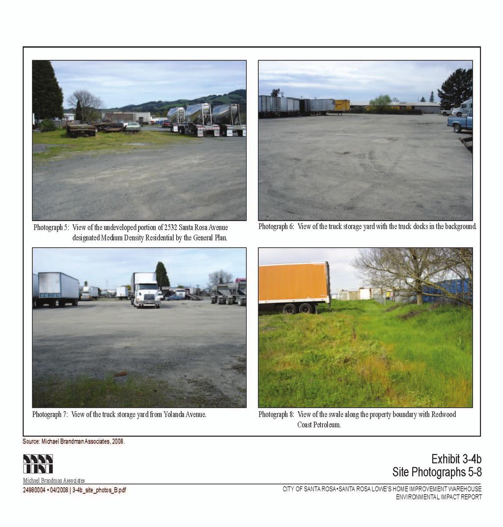
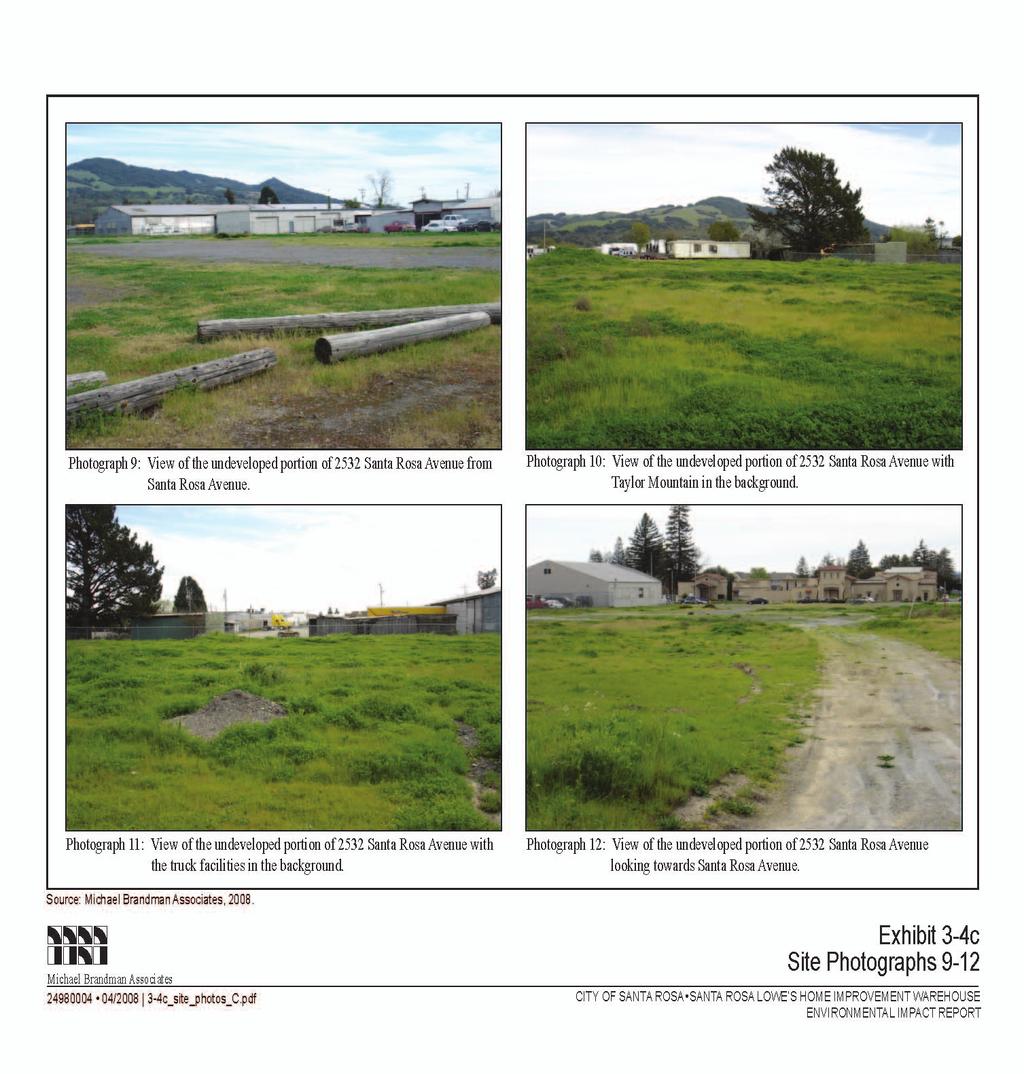
2 Project Description Santa Rosa Lowe s Home Improvement Warehouse Project Draft EIR APN (325 Yolanda Avenue) is a rectangular-shaped, 5.46-acre parcel fronting Yolanda Avenue occupied by Hulsman Transportation Co., which has continually occupied the site since the 1930s. The site has historically been used for trucking-related operations, and Hulsman Transportation Co. leases storage facilities on the site to trucking firms and owner-operators. Seven buildings are located on this parcel and are summarized below: A large, open-air, wood-frame dock terminal is located in the western portion of the parcel and is currently used by Matheson Fast Freight. This is the largest structure onsite and dates to the 1930s. A small, wood-frame building is located west of the dock terminal and used as offices. This building dates to the 1930 or 1940s. A metal Quonset hut is located east of the dock and is used for storage. This building dates to Three storage buildings (two wood-frame and one cinder-block) are located in the center of the property. The wooden buildings date to the 1940s and the cinder block building to the 1950s. A mobile home used as an office is located north of the storage buildings. The mobile home was moved onsite in the 1960s. A large, gravel-covered vehicle storage area occupied the eastern portion of the parcel. A swale is present along the eastern portion of the parcel, adjacent to the fence line with Redwood Coast Petroleum. Mature ornamental landscaping is present in various portions of the parcel, including a stand of redwood trees located along the Yolanda Avenue frontage. A groundwater well is present near the Quonset hut that is used for non-potable purposes. This parcel is the source of a groundwater gasoline plume that originated from leaking underground storage tanks (USTs) on the property. The leak was discovered in 1988 when two USTs were removed. The plume is believed to be commingled with another plume that originated on the south side of Yolanda Avenue. Five monitoring wells are in place to observe the plume. In addition, three monitoring wells are in place on the eastern portion of the parcel to monitor a plume associated with Redwood Coast Petroleum. APN (2532 Santa Rosa Avenue) is a rectangular-shaped, undeveloped parcel that abuts Santa Rosa Avenue. The western portion of this parcel contains ruderal (weedy) vegetation, and the eastern portion is used for vehicle storage. The western portion of the site was formerly used for mobile home sales, which ceased in Natoli Parcels The Natoli-owned portion of the project site totals 1.31 acres and is occupied by automotive service businesses. 3-2 Michael Brandman Associates H:\Client (PN-JN)\2498\ \DEIR\ _Sec03-00 Project Description.doc
3
4
5
6


7 Source: City of Santa Rosa, NORTH NOT TO SCALE Michael Brandman Associates / _parcel_map.pdf Exhibit 3-3 Parcel Map CITY OF SANTA ROSA SANTA ROSA LOWE S HOME IMPROVEMENT WAREHOUSE ENVIRONMENTAL IMPACT REPORT
8
9
10
11
12
13
14
15
16
17 Santa Rosa Lowe s Home Improvement Warehouse Project Draft EIR Project Description APN (2612 Santa Rosa Avenue) contains one building occupied by Cartronics, an automotive accessory business (e.g., security, stereo, tinting, etc.) and metal shed in the rear. An inactive potable water well is present onsite. This parcel has historically been used for automotiverelated uses dating back to the 1960s. This parcel is entirely hardscaped. APN (2620 Santa Rosa Avenue) contains Quality Motors, a used car dealership that sells and services vehicles. Three buildings are present onsite: a showroom near the Santa Rosa Avenue frontage, an office in the rear, and a metal shed in the rear that is used for vehicle servicing. The shed contains three floor surface lifts, and vehicle fluids are stored onsite. An active potable water well is present onsite. This parcel has historically been used for automotive-related uses dating back to the 1960s. This parcel is entirely hardscaped Surrounding Land Uses West Santa Rosa Avenue and an existing McDonald s restaurant are located adjacent to the western boundary of the project site. Along the west side of Santa Rosa Avenue are a partial interchange with U.S. 101 (i.e., northbound off- and on-ramps) and the Chapel of the Chimes Crematorium. North A small commercial retail center and the Carriage Court Mobile Home Park form the northern boundary of the project site. The commercial retail center abuts Santa Rosa Avenue and is tenanted by Barbeques Galore, Mattress Discounters, and Verizon. The mobile home park is located behind the commercial center and forms the longest portion of the northern border. A dilapidated wooden fence demarcates the property line with the mobile home park. East Redwood Coast Petroleum, a local gas retailer and distributor, forms the eastern boundary of the project site. This facility includes indoor and outdoor storage facilities of petroleum vessels. A chain-link fence topped with razor wire delineates the property line. Redwood Coast Petroleum operates 24 hours a day. South Yolanda Avenue forms the southern boundary of the project site. Along the south side of Yolanda Avenue are mix of land uses, including light industry (machining and metalwork), heavy commercial (automotive repair and equipment rental), detached single-family residences, and commercial retail (fireplace and recreational vehicle sales) General Plan and Zoning Designations The General Plan and Zoning Code designations for the four parcels constituting the project site are shown in Table 3-2. Michael Brandman Associates 3-17 H:\Client (PN-JN)\2498\ \DEIR\ _Sec03-00 Project Description.doc
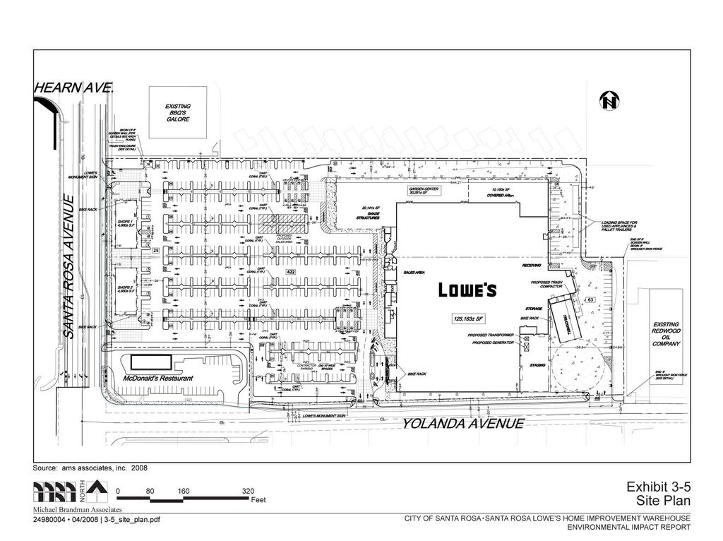
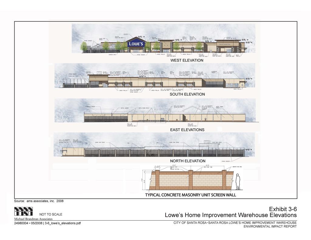
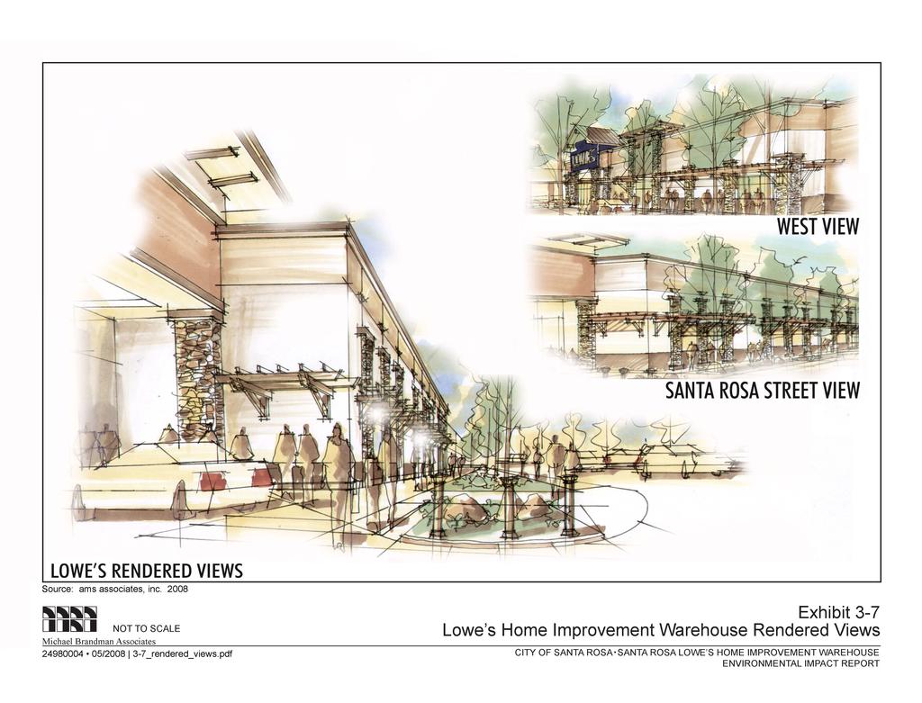
18 Project Description Santa Rosa Lowe s Home Improvement Warehouse Project Draft EIR Assessor s Parcel No. Table 3-2: General Plan and Zoning Designations Situs Address Santa Rosa Avenue Yolanda Avenue Santa Rosa Avenue Santa Rosa Avenue Acreage Existing Land Use Land Use Designation General Plan 0.79 Automotive uses Retail and Business Services Zoning General Commercial 5.46 Trucking uses Light Industry General Commercial 0.52 Automotive uses Retail and Business Services 5.00 Undeveloped (2.30 acres) Vehicle storage (2.70 acres) Source: City of Santa Rosa, 2008; Michael Brandman Associates, Retail and Business Services Medium Density Residential General Commercial General Commercial General Commercial Project Characteristics Proposed Project The proposed project consists of the development of approximately 165,000 square feet of commercial retail uses, including a Lowe s Home Improvement Warehouse, smaller retail uses, and associated parking and infrastructure, on the project site. The project site plan is shown in Exhibit 3-5. Each component is described below Lowe s Home Improvement Warehouse The proposed Lowe s Home Improvement Warehouse would total 155,454 square feet, with 125,163 square feet of interior uses and 30,291 square feet of garden center uses. The store would be located on the eastern portion of the project site and oriented to face Santa Rosa Avenue. Loading facilities would be located in the rear of the store and would include a truckwell and staging area. The store would operate during the following hours: Monday through Saturday, 6 a.m. to 10 p.m. and Sunday, 7 a.m. to 10 p.m. Design and Appearance The Lowe s store would employ a unique design that incorporates elements representative of the Santa Rosa area. Design elements include a gabled main entrance, stone veneer, wood trellises, and a stucco finish. The garden center would be enclosed with a decorative fence interspersed with stone veneer columns and partially covered with an aluminum canopy. All rooftop-mounted equipment would be concealed from public view by parapets. The roofline of the Lowe s Home Improvement Warehouse would range from 28 feet, 8 inches to 36 feet above grade, except at the store entrance, 3-18 Michael Brandman Associates H:\Client (PN-JN)\2498\ \DEIR\ _Sec03-00 Project Description.doc
19
20
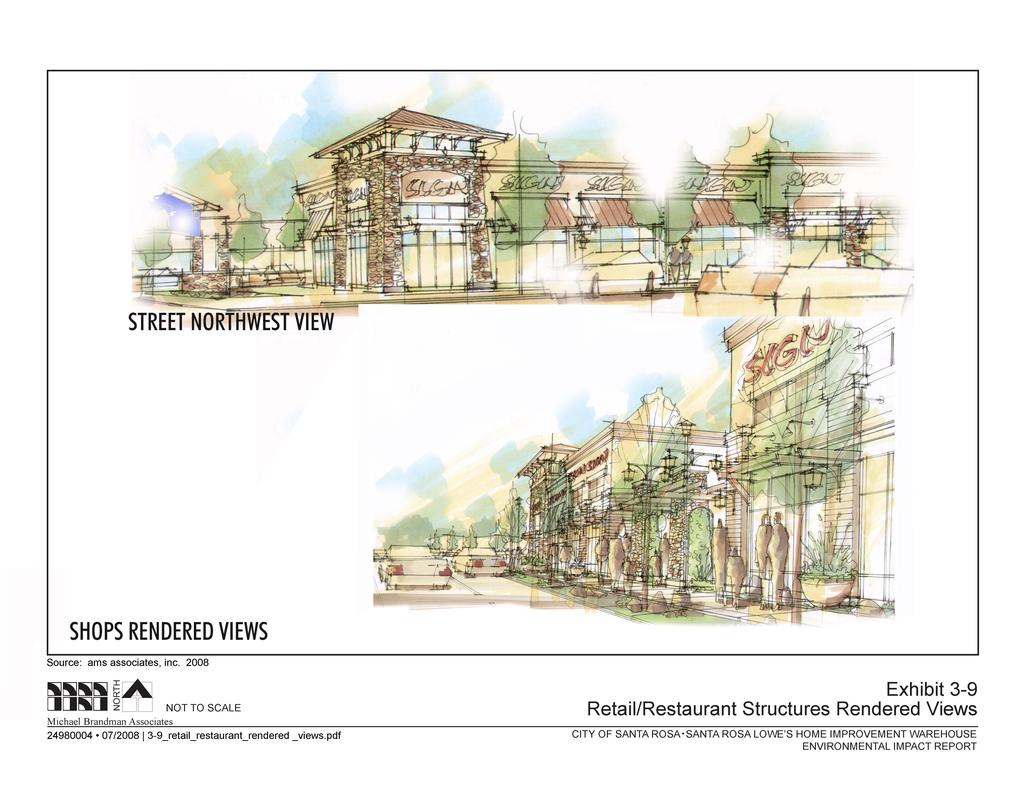
21 Santa Rosa Lowe s Home Improvement Warehouse Project Draft EIR Project Description where a gable would extend to 45 feet above grade. Elevations of the Lowe s Home Improvement Warehouse are provided in Exhibit 3-6. Rendered views of the Lowe s Home Improvement Warehouse are provided in Exhibit 3-7. Note that the elevations and rendered views are intended to provide a conceptual representation of store aesthetics, and minor revisions may occur during final design. Truck Deliveries The proposed project would receive 15 to 20 semi truck deliveries per day (Monday through Friday) and 10 to 18 flatbed truck and panel van deliveries per week. Truck deliveries are anticipated to occur between the hours of 6:30 a.m. and 6:00 p.m. The semi trucks would back up to the docks, with all loading and unloading occurring inside the store. The driveway at this point provides a turnaround with sufficient radius for this purpose and for the trucks to exit the site at the secondary access. Flatbed trucks would deliver to the lumber area, with materials offloaded with forklifts and transported inside the store. Flatbed trucks and panel vans would also deliver to the garden center. Emergency Generator A 350-kilowatt emergency diesel generator would be located in the rear of the Lowe s Home Improvement Warehouse. The generator would be used to provide electricity to the store during power outages Retail/Restaurant Uses The proposed project would locate two 4,500-square-foot retail/restaurant buildings (9,000 square feet total) adjacent to the Santa Rosa Avenue frontage. No end users have been identified; however, the project applicant anticipates the square footage would be tenanted by several small retailers or restaurants. These tenants are anticipated to have the same hours of operation as the Lowe s Home Improvement Warehouse. Design and Appearance The retail/restaurant structures would incorporate many of the same design elements as the Lowe s Home Improvement Warehouse to achieve a consistent design between the two structures. The focal point of the structure would be a hipped-roof entrance adjacent to the driveway at Santa Rosa Avenue. The façade of the building would employ cultured stone, wood trellises, stucco finishes, and metal awnings and roofing. The roofline of the retail structure would range from 23 feet, 10 inches to 35 feet above grade at the peak of the hipped roof. Elevations of the retail structure are provided in Exhibit 3-8. Rendered views of the retail/restaurant structures are provided in Exhibit 3-9. Note that the elevations are intended to provide a conceptual representation of aesthetics and minor revisions may occur during final design. Michael Brandman Associates 3-21 H:\Client (PN-JN)\2498\ \DEIR\ _Sec03-00 Project Description.doc
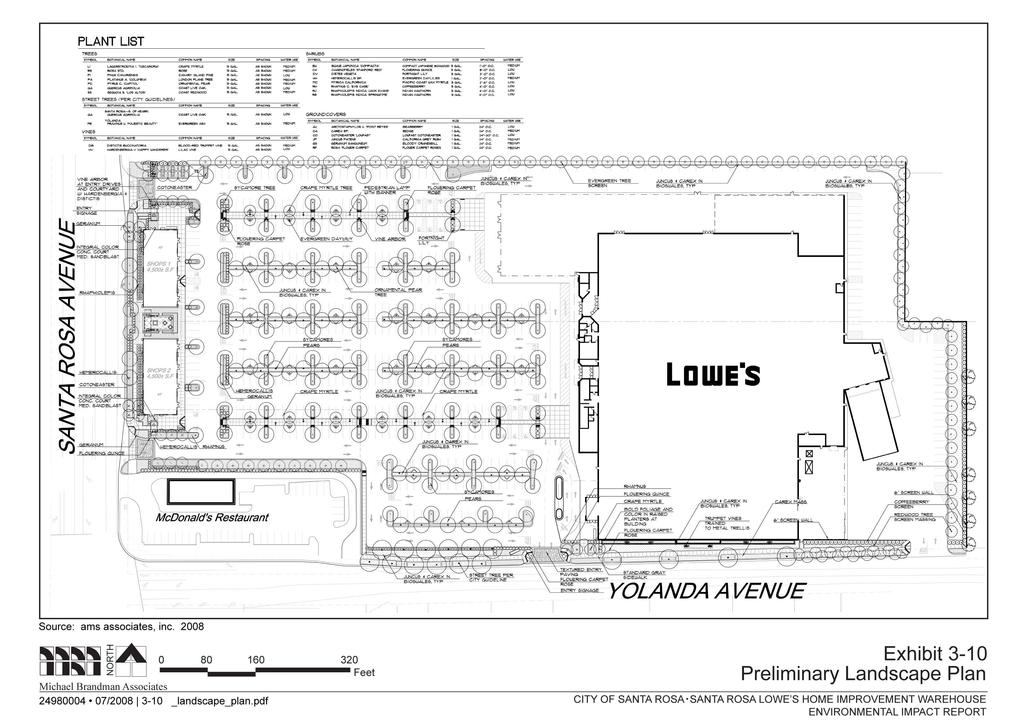
22 Project Description Santa Rosa Lowe s Home Improvement Warehouse Project Draft EIR Site Access and Parking Vehicular Access Vehicular access to the proposed project would be taken at four access points: Two access points on Santa Rosa Avenue, serving the main parking lot for the Lowe s and retail/restaurant uses Two access points on Yolanda Avenue, with one serving the Lowe s portion of the main parking lot and the other providing truck access to the Lowe s loading docks Pedestrian Access Sidewalks would be installed along the project frontages with Santa Rosa Avenue and Yolanda Avenue. Pedestrian walkways would be provided within the parking area to link the Lowe s with the retail/restaurant structure. The walkways would also connect with the sidewalks along Santa Rosa Avenue and Yolanda Avenue and may connect with the adjacent McDonald s restaurant. Parking Table 3-3 summarizes the proposed project s off-street parking. As shown in the table, the proposed project would provide 510 off-street parking spaces, with 494 standard spaces and 16 disabled spaces. Table 3-3: Parking Schedule Stall Type Count Standard 494 Disabled 16 Total Parking 510 Source: AMS Associates, Landscaping Landscaping would be provided in the parking lot and along the frontages with Santa Rosa Avenue and Yolanda Avenue. Anticipated landscaping elements include shade trees in the parking lot, and accent trees, shade trees, groundcover, and shrubs along project frontages with Santa Rosa Avenue, Yolanda Avenue, and the property boundaries to the north and east. The landscape plan is provided in Exhibit Utility Infrastructure The City of Santa Rosa would provide potable water and wastewater services to the proposed project. The proposed project would provide onsite drainage infrastructure to collect and detain runoff in a manner that would prevent it from leaving the project site at a rate no greater than the predevelopment condition of the site. Pacific Gas and Electric Company would provide electricity and natural gas services to the project Michael Brandman Associates H:\Client (PN-JN)\2498\ \DEIR\ _Sec03-00 Project Description.doc
23
24
25
26

27
28
29
30
31
32
33 Santa Rosa Lowe s Home Improvement Warehouse Project Draft EIR Project Description Frontage Improvements The City of Santa Rosa General Plan designates Yolanda Avenue as a Regional/Arterial and contemplates extending the roadway from its current terminus at Petaluma Hill Road to Farmers Lane. The General Plan anticipates widening the roadway in the project vicinity to four through travel lanes. Accordingly, the proposed project s frontage improvements along Yolanda Avenue would provide sufficient right-of-way dedication to the City for the planned widening of the roadway. Frontage improvements would include curb, gutter, and sidewalk. The proposed project would also provide frontage improvements and right-of-way dedication along Santa Rosa Avenue. New curbs, gutters, and sidewalks would be installed Employment The proposed project would create an estimated 218 employment opportunities. Of this figure, 200 jobs would be associated with the Lowe s Home Improvement Warehouse and the remaining 18 opportunities would be associated with the 9,000 square feet of smaller retail and restaurant uses. The Lowe s employment estimate was provided by the company, while smaller retail estimate was derived by applying a standard rate of one job per 500 square feet of retail and restaurant space. Approximately 75 percent of the employment opportunities would be full-time, while the remaining 25 percent would be part-time. Most of the employment opportunities would be entry-level Project Implementation Construction activities may begin as early as 2009 and take 12 months to complete, with the project being operational by For the purposes of this EIR, it will be assumed that construction occurs in 2009 and operations begin Project Objectives The objectives of the proposed project are to: Enhance the commercial retail opportunities in Santa Rosa and surrounding unincorporated areas of Sonoma County. Create new employment opportunities for local residents. Contribute to the long-term fiscal health of Santa Rosa by increasing the local tax base. Provide a retail establishment that serves local residents and businesses with essential goods and services in a safe, secure, and convenient shopping environment. Develop a home improvement retail store of sufficient size to serve existing and future demand in the Santa Rosa market area. Redevelop an underutilized commercial site in an existing urbanized area of Santa Rosa. Michael Brandman Associates 3-33 H:\Client (PN-JN)\2498\ \DEIR\ _Sec03-00 Project Description.doc
34 Project Description Santa Rosa Lowe s Home Improvement Warehouse Project Draft EIR Enhance the visual quality of the Santa Rosa Avenue and Yolanda Avenue corridors. Promote economic growth and development that is consistent with the policies of the City of Santa Rosa General Plan. Generate sales tax and property tax revenues to accrue to the various agencies within the project area. Require new development to pay for its fair share of impacts. Minimize travel lengths and utilize existing infrastructure to the maximum extent possible through infill redevelopment. Maximize efficient traffic circulation by locating a big box retail project adjacent to an interchange with U.S Facilitate the General Plan s objective of widening and upgrading Yolanda Avenue by dedicating the necessary right-of-way and providing fee payments to the City for this project. Develop an architectural design that softens the scale and mass of the buildings with features designed to blend with the surrounding area Intended Uses of This Draft EIR This Draft EIR is being prepared by the City of Santa Rosa to assess the potential environmental impacts that may arise in connection with actions related to implementation of the proposed project. Pursuant to CEQA Guidelines Section 15367, the City of Santa Rosa is the lead agency for the proposed project and has discretionary authority over the proposed project and project approvals. The Draft EIR is intended to address all public infrastructure improvements and all future development that are within the parameters of the proposed project Discretionary and Ministerial Actions As identified previously, discretionary approvals and permits are required by the City of Santa Rosa for implementation of the proposed project. The project application will require the following discretionary approvals and actions, including: General Plan Amendment - City Council Zoning Clearance - City Staff Major Conditional Use Permit - Planning Commission Design Review - Design Review Board The proposed project would include a General Plan Amendment to re-designate 8.16 acres of the Hulsman parcels to Retail and Business Services, consistent with the existing designations for the balance of the project site. The General Plan Amendment is only necessary for the 2.7 acres 3-34 Michael Brandman Associates H:\Client (PN-JN)\2498\ \DEIR\ _Sec03-00 Project Description.doc
35 Santa Rosa Lowe s Home Improvement Warehouse Project Draft EIR Project Description designated Medium Density Residential (2532 Santa Rosa Avenue); the proposed Lowe s Home Improvement Warehouse could be developed on the 5.46-acre parcel designated Light Industry (325 Yolanda Avenue). However, to achieve a uniform General Plan designation of Retail and Business Services for the entire project site, the project applicant has included the 325 Yolanda Avenue parcel in the General Plan Amendment request. The proposed project would require a zoning clearance to verify that its uses are allowed within the General Commercial (CG) zoning district. The proposed project would be required to obtain a major conditional use permit, because it would contain three or more uses sharing a common vehicular and pedestrian area and, therefore, would constitute a shopping center under the Santa Rosa City Code. Shopping centers are conditional uses in the General Commercial (CG) zoning district. Design review is required for the entire project. Subsequent ministerial actions will be required for the implementation of the proposed project including: Encroachment Permit - City of Santa Rosa Demolition Permit - City of Santa Rosa Grading Permit - City of Santa Rosa Building Permit - City of Santa Rosa Mechanical Permit - City of Santa Rosa Plumbing Permit - City of Santa Rosa Electrical Permit - City of Santa Rosa Fire Systems Permit - City of Santa Rosa Fencing Permit - City of Santa Rosa Responsible and Trustee Agencies A number of other agencies in addition to the City of Santa Rosa will serve as Responsible and Trustee Agencies, pursuant to CEQA Guidelines Section and Section 15386, respectively. This Draft EIR will provide environmental information to these agencies and other public agencies, which may be required to grant approvals or coordinate with other agencies, as part of project implementation. These agencies may include, but are not limited to, the following: Bay Area Air Quality Management District (BAAQMD) California Department of Fish and Game (CDFG) North Coast Regional Water Quality Control Board (RWQCB) Michael Brandman Associates 3-35 H:\Client (PN-JN)\2498\ \DEIR\ _Sec03-00 Project Description.doc
36 Project Description Santa Rosa Lowe s Home Improvement Warehouse Project Draft EIR Required actions that must be taken by other agencies to implement the project are: Obtain coverage under the General Construction Permit. Project construction would require coverage under the General Construction Permit issued to the State Water Quality Control Board. A Storm Water Pollution Prevention Plan must be submitted in order to obtain coverage Michael Brandman Associates H:\Client (PN-JN)\2498\ \DEIR\ _Sec03-00 Project Description.doc
Memorandum / Letter of Intent
 VERONA WAUKESHA KENOSHA APPLETON WESTON Memorandum / Letter of Intent To: Adam Sayre, Director of Planning & Development, City of Verona From: Kevin Yeska, JSD Professional Services, Inc. www.jsdinc.com
Bloor Street West Rezoning Application for a Temporary Use By-law Final Report
 STAFF REPORT ACTION REQUIRED 3741 3751 Bloor Street West Rezoning Application for a Temporary Use By-law Final Report Date: June 12, 2007 To: From: Wards: Reference Number: Etobicoke York Community Council
Section 61 Recreational Vehicle Park / Campground (Bylaw No. 2012/10)
") Part 7 General Regulations Section 61 Recreational Vehicle Park / Campground (Bylaw No. 2012/10) 61.1 A comprehensive site plan shall be provided to the satisfaction of the Development Authority that shows
Part 7 General Regulations Section 61 Recreational Vehicle Park / Campground (Bylaw No. 2012/10) 61.1 A comprehensive site plan shall be provided to the satisfaction of the Development Authority that shows
URBAN DESIGN REPORT. Proposed Residential Development, Old Church Road, Caledon East
 Proposed Residential Development, Old Church Road, Caledon East TABLE CONTENTS: 1.0 DEVELOPMENT 1.1 Introduction-Analysis of Guiding Principles and Documents 1.2 Community Design and Architectural Design
Development Agreement No. DA16-002
 STAFF REPORT Planning Commission AGENDA ITEM NUMBER 5 MEETING DATE April 13, 2016 CASE NUMBER PROPERTY OWNER PROJECT PROPONENTS City of Buena Park as Successor Agency to the former Community Redevelopment
b. Minimum Site Area. Recreational vehicle parks shall be located on a parcel of land not less than 3 acres in area.
 6450 RECREATIONAL VEHICLE PARK REGULATIONS 6450 TITLE AND PURPOSE. The provisions of Section 6450 through 6499, inclusive, shall be known as the Recreational Vehicle Park Regulations. The purpose of these
Architectural Review Commission
 Architectural Review Commission staff report Item 3: Project Planner: Applicant/Owner: VITALITY BOWLS SIGNAGE APPEAL 100 CRESCENT DRIVE PLN 14-0473 Jeff Olsen, (925) 671-5206, jolsen@ci.pleasant-hill.ca.us
Staff Report. Re: National Park Service Ferry Landing Facilities at Piers 31, 31½ and 33 Joint Meeting with BCDC Design Review Board
 Port of San Francisco Waterfront Design Advisory Committee Agenda Item No. 1 Meeting Date: Staff Report To: From: Waterfront Design Advisory Committee: Laura Crescimano Jeff Joslin Marsha Maytum Kathrin
VI. ALTERNATIVES TO THE MASTER PLAN C. RENOVATED EAST BUILDING ALTERNATIVE
 VI. ALTERNATIVES TO THE MASTER PLAN C. RENOVATED EAST BUILDING ALTERNATIVE INTRODUCTION The Renovated East Building Alternative would include the continued use of the renovated West Building and the renovation
City of Redding Airports
 City of Redding Airports Benton Airpark Redding Municipal Airport DEVELOPMENT AND USE GUIDELINES FOR GENERAL AVIATION HANGARS April 7, 2009 PREFACE The City of Redding, as owner of federally obligated
Airport Planning Area
 PLANNING AREA POLICIES l AIRPORT Airport Planning Area LOCATION AND CONTEXT The Airport Planning Area ( Airport area ) is a key part of Boise s economy and transportation network; it features a multi-purpose
Construction Staging Area Blue Jays Way (357 King Street West)
") REPORT FOR ACTION Construction Staging Area Blue Jays Way (357 King Street West) Date: June 8, 2018. To: Toronto and East York Community Council From: Acting Director, Transportation Services, Toronto
REPORT FOR ACTION Construction Staging Area Blue Jays Way (357 King Street West) Date: June 8, 2018. To: Toronto and East York Community Council From: Acting Director, Transportation Services, Toronto
This section evaluates the projected traffic operations and circulation impacts associated with the proposed upgrade and expansion of the LWRP.
 4.5 TRAFFIC AND CIRCULATION This section evaluates the projected traffic operations and circulation impacts associated with the proposed upgrade and expansion of the LWRP. 4.5.1 Environmental Setting Existing
CITY OF PALMDALE. REPORT to the Mayor and Members of the City Council from the City Manager
 CITY OF PALMDALE REPORT to the Mayor and Members of the City Council from the City Manager DATE: June 4, 2014 SUBJECT: Specific Plan Amendment 14-01; Amending the Use Designation of 23.97 Acres within
RECREATIONAL VEHICLE EXAMPLES
 RV Ordinance 21.03.010 (I). Recreational Vehicles. 1. Purpose. The purpose of the recreational vehicle (RV) code is to clearly define what is considered a recreational vehicle and to identify locations
CHAPTER 4 -- THE LAND USE PLAN: DESCRIPTIONS AND POLICIES FOR THIRTEEN PLANNING AREAS
 CHAPTER 4 -- THE LAND USE PLAN: DESCRIPTIONS AND POLICIES FOR THIRTEEN PLANNING AREAS NORTH CENTRAL CAC AREA LITTLE VALLEY ROAD TO JUG HANDLE CREEK PLANNING AREA This planning area includes Cleone, Noyo,
A. CONCLUSIONS OF THE FGEIS
 Chapter 11: Traffic and Parking A. CONCLUSIONS OF THE FGEIS The FGEIS found that the Approved Plan will generate a substantial volume of vehicular and pedestrian activity, including an estimated 1,300
2433 Dufferin Street Zoning By-law Amendment Application - Preliminary Report
 STAFF REPORT ACTION REQUIRED 2433 Dufferin Street Zoning By-law Amendment Application - Preliminary Report Date: July 22, 2014 To: From: Wards: Reference Number: North York Community Council Director,
OFFERING MEMORANDUM. Applebee s - Ground Lease Walmart Supercenter Outparcel Warren, MI
 Applebee s - Ground Lease Walmart Supercenter Outparcel Warren, MI Florida Investment Sales Exclusively Retail. Extensive Solutions. JOHN ARTOPE Executive Vice President, Market Leader D 407.902.2621 john.artope@srsre.com
RECREATIONAL VEHICLE RESORT DISTRICT R-RVR. Lacombe County Land Use Bylaw No: 1237/17 Date Adopted: July 6, Page 111
 RECREATIONAL VEHICLE RESORT DISTRICT Page 111 7.10 RECREATIONAL VEHICLE RESORT DISTRICT () 1 PURPOSE 2 USES The purpose of the Recreational Vehicle Resort District is to provide an area that will facilitate
Department of Planning & Development Services
 Department of Planning & Development Services S T A F F R E P O R T May 31, 2016 CASE NO: PROJECT: EXECUTIVE SUMMARY: DETAILS: ZA16-032 Site Plan for Manny s Tex Mex Wyndham Properties II Ltd. is requesting
Southwind Marina Sinton Drive Pensacola, Florida Unique Opportunity to Acquire a 90 Slip Marina With Excellent Investment Potential
 Urban Realty Southeast is pleased to present Southwind Marina 10121 Sinton Drive Pensacola, Florida 32507 Unique Opportunity to Acquire a 90 Slip Marina With Excellent Investment Potential Closest marina
MONTGOMERY COUNTY PLANNING DEPARTMENT THE MARYLAND-NATIONAL CAPITAL PARK AND PLANNING COMMISSION
 MONTGOMERY COUNTY PLANNING DEPARTMENT THE MARYLAND-NATIONAL CAPITAL PARK AND PLANNING COMMISSION MCPB Item No. Date: 6/23/2016 Lucy V. Barnsley Elementary School Addition, Mandatory Referral MR2016027
As the Toronto Transit Commission (TTC) operates a transit service on Bay Street, City Council approval of this report is required.
 operates a transit service on Bay Street, City Council approval of this report is required.") REPORT FOR ACTION Construction Staging Area - 81 Bay Street Date: December 11, 2017 To: Toronto and East York, Community Council From: Acting Director, Transportation Services Toronto and East York District
REPORT FOR ACTION Construction Staging Area - 81 Bay Street Date: December 11, 2017 To: Toronto and East York, Community Council From: Acting Director, Transportation Services Toronto and East York District
APPLICATION FOR SITE DEVELOPMENT PLAN LETTER OF INTENT Amended
 Est. 1982 Est. 1982 Urban Planning Community Design Landscape Architecture 731 North Weber Street, Suite 10, Colorado Springs, CO 80903, 719 633-9700 http://www.gumanltd.com/ Members American society of
Section 106 Update Memo #1 Attachment D. Traffic Diversion & APE Expansion Methodology & Maps
 Section 106 Update Memo #1 Attachment D Traffic Diversion & APE Expansion Methodology & Maps I-65/I-70 North Split Interchange Reconstruction Project (Des. Nos. 1592385 & 1600808) Traffic Diversion and
Concept Curtin Precinct Map and Code
 Concept Curtin Precinct Map and Code Proposed changes from the revised Curtin Group Centre Draft Master Plan recommendations Disclaimer: This document is intended to show the proposed changes to the existing
WHITEHALL PLANNING COMMISSION MINUTES MARCH 3, 2016
 WHITEHALL PLANNING COMMISSION MINUTES MARCH 3, 2016 The Whitehall Planning Commission meeting of March 3, 2016 was called to order by Chairman Terry Anderson 6:30 PM. Chairman Anderson asked for a roll
The implementation of this Master Plan will be undertaken in logical stages to meet passenger and workforce demands.
 The implementation of this Master Plan will be undertaken in logical stages to meet passenger and workforce demands. Connecting People Building Opportunities 198 Brisbane Airport Corporation CHAPTER 10
Alternative Highest & Best Use Analysis Boutique Hotel
 Alternative Highest & Best Use Analysis In response to numerous comments received from the public, as well as issues raised by the CCC in the Appeal Staff Report Substantial Issue Determination, the following
SK 1.0 SITE STATISTICS PRELIMINARY DOCUMENTS. PROPOSED APARTMENT BUILDING 115 & 117 ERB STREET EAST Waterloo, Ontario PROJECT: DATE: REFERENCE: -
 SITE STATISTICS SCALE: N.T.S. SK 1.0 2442 PROPOSED APARTMENT BUILDING ERB STREET EAST R6000 R3000 BEFORE ROAD WIDENING AFTER ROAD WIDENING LANDSCAPED AREA T 4216 5000 5.0m MIN. FRONT YARD SETBACK (BY-LAW
Site Location and Setting
 Memorandum Date: To: From: Subject: Kristy Le, Gary Black Steve Orem Santa Teresa County Park Historic Area Traffic and Parking Study Hexagon Transportation Consultants, Inc. has completed a traffic and
DRAFT GENERAL IMPLEMENTATION PLAN AND SPECIFIC IMPLEMENTATION PLAN MIDDLETON MUNICIPAL AIRPORT MOREY FIELD. Revised 12/12/03
 DRAFT GENERAL IMPLEMENTATION PLAN AND SPECIFIC IMPLEMENTATION PLAN MIDDLETON MUNICIPAL AIRPORT MOREY FIELD Revised 12/12/03 As recommended for approval by the Plan Commission General Project Description
RAY YENKANA Willowbrook Cr, Dawson Creek BC Canada $2,847,000
 1716 Willowbrook Cr, Dawson Creek BC Canada For SALE $2,847,000 This is a rare find, 32 townhomes in Dawson Creek, BC. Excellent investment in a single title multi family complex. Vendor has upgraded this
David Magney Environmental Consulting
 David Magney Environmental Consulting DELINEATION OF JURISDICTIONAL WATERS AND RIPARIAN HABITATS FOR LYONS CANYON RANCH, NEWHALL, CALIFORNIA Prepared for: UNITED STATES ARMY CORPS OF ENGINEERS and CALIFORNIA
Spadina Avenue Built Form Study Preliminary Report
 STAFF REPORT ACTION REQUIRED Spadina Avenue Built Form Study Preliminary Report Date: July 9, 2014 To: From: Wards: Reference Number: Toronto and East York Community Council Director, Community Planning,
Date: 11 th January, From: Plaistow & Ifold Parish Neighbourhood Plan - Steering Group. Plaistow & Ifold Parish Council
 Date: 11 th January, 2017 From: Plaistow & Ifold Parish Neighbourhood Plan - Steering Group To: Plaistow & Ifold Parish Council Re: Neighbourhood Plan Report to Parish Council Meeting 17 Jan 2017 The Steering
Town of Markham Yonge and Steeles Corridor Study and City of Vaughan Yonge Street Area Study
 STAFF REPORT ACTION REQUIRED Town of Markham Yonge and Steeles Corridor Study and City of Vaughan Yonge Street Area Study Date: August 14, 2009 To: From: Wards: Reference Number: North York Community Council
3. COLTA / HUGA CONNECTIONS - PRELIMINARY
 9 3. COLTA / HUGA CONNECTIONS - PRELIMINARY 3.1 COLTA The Chain of Lakes Trail Association (COLTA) trail, formerly identified as the Chester Spur Line, was completed and opened for use in June 2011. The
CHAPTER 16 STREETS, SIDEWALKS AND OTHER PUBLIC PLACES*
 CHAPTER 16 STREETS, SIDEWALKS AND OTHER PUBLIC PLACES* *Cross reference(s)--drainage commission, 2-111 et seq.; drainage districts created, 2-114; planning commission shall select and recommend to the
Community Development Department Council Chambers, 7:30 PM, December 20, 2012
 STAFF REPORT 2012-56P: Alley Vacation Community Development Department Council Chambers, 7:30 PM, December 20, 2012 To: From: Re: Paul Luke, Chairman, Skokie Plan Commission Mike Voitik, Planning Technician
RESORT AREA STRATEGIC ACTION PLAN (RASAP) STEERING COMMITTEE MEETING - APRIL 3, 2019
 STEERING COMMITTEE MEETING - APRIL 3, 2019") RESORT AREA STRATEGIC ACTION PLAN (RASAP) STEERING COMMITTEE MEETING - APRIL 3, 2019 Welcome & Introductions - Deb Zywna AGENDA FY 20 Resort CIP Proposed Projects - Kathy Warren ORDFBC Design Guidelines
RESORT AREA STRATEGIC ACTION PLAN (RASAP) STEERING COMMITTEE MEETING - APRIL 3, 2019 Welcome & Introductions - Deb Zywna AGENDA FY 20 Resort CIP Proposed Projects - Kathy Warren ORDFBC Design Guidelines
Figure San Dimas Bonita at San Dimas Avenue (view looking west)
") The adjoining neighborhood has an eclectic assortment of building types and uses, including: the historically significant but not architecturally or visually noteworthy San Dimas Lemon Association Packing
The adjoining neighborhood has an eclectic assortment of building types and uses, including: the historically significant but not architecturally or visually noteworthy San Dimas Lemon Association Packing
ORDINANCE NO. JACKSON TOWNSHIP, CAMBRIA COUNTY
 ORDINANCE NO. JACKSON TOWNSHIP, CAMBRIA COUNTY AN ORDINANCE OF THE TOWNSHIP OF JACKSON AMENDING SECTIONS OF THE JACKSON TOWNSHIP ZONING ORDINANCE AS FOLLOWS: PROVIDING NEW DEFINITIONS OF CAMPGROUNDS, CAMPSITE,
Project Deliverable 4.1.3d Individual City Report - City of La Verne
 Pomona Valley ITS Project Project Deliverable 4.1.3d Individual City Report - City of La Verne Prepared by: April 19, 2002 099017000.1 Copyright 2002, Kimley-Horn and Associates, Inc TABLE OF CONTENTS
VILLAGE OF ALGONQUIN PLANNING AND ZONING COMMISSION Meeting Minutes William J. Ganek Municipal Center-Board Room February 13, :30 p.m.
 VILLAGE OF ALGONQUIN PLANNING AND ZONING COMMISSION Meeting Minutes William J. Ganek Municipal Center-Board Room February 13, 2017 7:30 p.m. AGENDA ITEM 1: Present: Absent: Staff Members Present: Roll
Grade Crossings in High Speed Rail Corridors
 Grade Crossings in High Speed Rail Corridors 59 th ANNUAL ILLINOIS TRAFFIC ENGINEERING & SAFETY CONFERENCE October 21, 2010 Champaign, IL Michael E. Stead Rail Safety Section Illinois Commerce Commission
A. From I-68 in Monongalia County, West Virginia to SR 6119 in Fayette County, Pennsylvania 1
 Mon-Fayette Transportation Project A. From I-68 in Monongalia County, West Virginia to SR 6119 in Fayette County, Pennsylvania 1 The Mon/Fayette Transportation Project (MFTP) from I-68 in West Virginia
Village of Skokie Downtown Area Sign Guidelines. for CX Core Mixed Use Zoning District
 Village of Skokie Downtown Area Sign Guidelines for CX Core Mixed Use Zoning District January 2011 (c) 2011 Published by the Village of Skokie, 5127 W. Oakton Street, Skokie, Illinois 60077 Signs are important
401, and 415 King Street West - Zoning Amendment Application - Preliminary Report
 STAFF REPORT ACTION REQUIRED 401, 407-409 and 415 King Street West - Zoning Amendment Application - Preliminary Report Date: January 27, 2011 To: From: Wards: Reference Number: Toronto and East York Community
Great Wolf Lodge Fact Sheet & Frequently Asked Questions Potential Location in Gilroy, California 8/30/17
 WHAT? Great Wolf Resorts has identified Gilroy, California as a potential location for a new Great Wolf Lodge family resort and has entered into a 60-day period of exclusivity with the City and community
3. Proposed Midwest Regional Rail System
 3. Proposed Midwest Regional Rail System 3.1 Introduction The proposed Midwest Regional Rail System (MWRRS) will operate in nine states, encompass approximately 3,000 route miles and operate on eight corridors.
HEARST GARDENS BERKELEY, CA 94702
 APPLICANT: RHOADES PLANNING GROUP 1611 TELEGRAPH AVE. SUITE 200 OAKLAND, CA 94612 [510] 545-4341 PROJECT: BERKELEY, CA 94702 ARCHITECT: DEVI DUTTA-CHOUDHURY, AIA DEVI DUTTA ARCHITECTURE INC. 1958A UNIVERSITY
Boston Redevelopment Authority 2/26/ Chestnut Hill Avenue Boston/Brookline, MA
 Boston Redevelopment Authority 2/26/2014 Cassidy Playground Waterworks Design revisions made since the DPIR submission March 2013 Massing - Reduced project 16,030 SF, for a total project area of 218,520
The Baker/Carver Regional Trail is intended to
 Section V Design Guidance The Baker/Carver Regional Trail is intended to safely accommodate 183,000 annual visits, an array of non-motorized uses, a variety of skill levels, and persons with special needs.
Appendix L Technical Memorandum Aesthetics
 Technical Memorandum Aesthetics 1.0 AESTHETICS This section provides a discussion of the aesthetic resources in the vicinity of ARTIC. Aesthetics pertain to the elements that make a certain view pleasing
SANTA CRUZ PROPERTY FOR SALE
 SANTA CRUZ PROPERTY FOR SALE 1911-1919 Soquel Avenue and 108 Eastgate Avenue Santa Cruz, CA 95062 Price: $5,387,000 Building Size: 15,447sf Land Size: 50,962sf 100% Leased to Longtime Tenants The information
Construction Staging Adelaide Street West
 REPORT FOR ACTION Construction Staging Adelaide Street West Date: October 6, 2016 To: Toronto and East York Community Council From: Acting Director, Transportation Services, Toronto and East York District
VRE Manassas Park Station Parking Expansion Alternatives Analysis
 VRE Manassas Park Station Parking Expansion Alternatives Analysis Summary Report September 18, 2017 THIS PAGE INTENTIONALLY LEFT BLANK Table of Contents 1.0 Introduction... 1 2.0 Summary of Existing Conditions...3
INVESTMENT SUMMARY. RESIDENTIAL COMMERCIAL ** *
 2017 Annual Report Belton Gateway Phase 2 Rendering INVESTMENT SUMMARY RESIDENTIAL 2015 2016 2017* NUMBER OF PERMITS ISSUED 18 106 101 INVESTMENT VALUE $2 Million $18 Million $20 Million COMMERCIAL 2015
Napa County Planning Commission Board Agenda Letter
 Agenda Date: 7/20/2011 Agenda Placement: 10A Napa County Planning Commission Board Agenda Letter TO: FROM: Napa County Planning Commission Hillary Gitelman - Director Conservation, Development & Planning
Downtown Cotati Residential/ Retail Site acres FOR SALE $3,950,000
 Downtown Cotati Residential/ Retail Site - 6.6 acres FOR SALE $3,950,000 Cotati, CA Situated only 40 miles north of San Francisco, Cotati is known as the Hub of Sonoma County since it is at the geographic
MEMORANDUM. Lynn Hayes LSA Associates, Inc.
 MEMORANDUM To: Lynn Hayes LSA Associates, Inc. Date: May 5, 217 From: Zawwar Saiyed, P.E., Senior Transportation Engineer Justin Tucker, Transportation Engineer I Linscott, Law & Greenspan, Engineers LLG
3450 Dufferin Street - Official Plan Amendment, Zoning Amendment and Draft Plan of Subdivision Applications Request for Directions Report
 STAFF REPORT ACTION REQUIRED 3450 Dufferin Street - Official Plan Amendment, Zoning Amendment and Draft Plan of Subdivision Applications Request for Directions Report Date: March 15, 2017 To: From: Wards:
1 PROJECT STATUS UPDATE 2 ND CONCESSION FROM BRISTOL ROAD TO DOANE ROAD TOWNS OF EAST GWILLIMBURY AND NEWMARKET
 Report No. 3 of the Regional Council Meeting of March 28, 2013 1 PROJECT STATUS UPDATE 2 ND CONCESSION FROM BRISTOL ROAD TO DOANE ROAD TOWNS OF EAST GWILLIMBURY AND NEWMARKET The recommends: 1. Receipt
1.2 Corridor History and Current Characteristics
 SECTION 1 Description and Background of Study Area 1.1 Introduction This preliminary engineering report was prepared for the Alaska Department of Transportation and Public Facilities (ADOT&PF). It is part
NEWBORO AND PORTLAND HARBOUR REDVELOPMENT PLANS
 INTRODUCTION The Municipal docks in both Newboro and Portland were transferred to the Township of Rideau Lakes by Parks Canada in 2002. Little has been done to improve the docks physical condition or role
City of Rolling Hills INCORPORATED JANUARY 24, 1957
 City of Rolling Hills INCORPORATED JANUARY 24, 1957 NO. 2 PORTUGUESE BEND ROAD ROLLING HILLS, CA 90274 (310) 377-1521 FAX (310) 377-7288 INSTRUCTIONS FOR COMPLETION OF THE LOT COVERAGE FORMS TOTAL STRUCTURES
TORONTO TRANSIT COMMISSION REPORT NO.
 Form Revised: February 2005 TORONTO TRANSIT COMMISSION REPORT NO. MEETING DATE: October 29, 2009 SUBJECT: TORONTO-YORK SPADINA SUBWAY EXTENSION PROJECT STEELES WEST STATION APPROVAL OF CONCEPTUAL DESIGN
Area Surrounding Maplewood Manor
 BAY CITY, MICHIGAN HOUSING COMMISSION Neighborhood Revitalization Plan Area Surrounding Maplewood Manor January 13, 2014 CITY COMMISSION DRAFT PLAN PRESENTATION BAY CITY, MICHIGAN 1 Planners Phil McKenna,
Access to the site is obtainable from the paved driveway leading to the MWD facility.
 County of Riverside Public Safety Enterprise Communication Project Appendix A: Candidate Site Descriptions Overview The site is located adjacent to a Metropolitan Water District (MWD) facility on El Sobrante
CA CA CA CA CA CA CA CA CA CA Educational facilities - public elementary and high schools and private schools with a curriculum similar to public
 (Y = Permitted) TABLE A (CA = Contract Agreement) PERMITTED USES BY DISTRICT Agricultural Uses (Light) Farming & Livestock related activities Y Y Y Y Y Y Agricultural Uses (Heavy) Commercial Type Animal
MONTGOMERY COUNTY PLANNING DEPARTMENT THE MARYLAND-NATIONAL CAPITAL PARK AND PLANNING COMMISSION
 MONTGOMERY COUNTY PLANNING DEPARTMENT THE MARYLAND-NATIONAL CAPITAL PARK AND PLANNING COMMISSION Three Sisters Road: Abandonment No. AB740 MCPB Item No. 11 Date: 5-1-14 Katherine Holt, Senior Planner,
PORT OF SEATTLE MEMORANDUM. COMMISSION AGENDA Item No. 6a ACTION ITEM Date of Meeting August 23, 2016
 PORT OF SEATTLE MEMORANDUM COMMISSION AGENDA Item No. 6a ACTION ITEM Date of Meeting August 23, 2016 DATE: TO: FROM: Michael Ehl, Director, Airport Operations Wayne Grotheer, Director, Aviation Project
Palm Beach County Redevelopment Sites State Road 7, Delray Beach, FL 33446
 14095 State Road 7, Delray Beach, FL 33446 Business Development Board of Palm Beach County, Inc. BDB.org 561.835.1008 1 2400 Metro Center Blvd - West Palm Beach - Lincoln College Business Development Board
Route 29 Solutions Projects
 Your guide to the Route 29 Solutions Projects For full details & continued engagement please visit www.route29solutions.org The Route 29 Solutions Package is a $230 million investment into the improvement
Georgetown-Lewes Rail/Trail Study. Rail/Trail Study: Cool Spring to Cape Henlopen State Park New Road Extension (House Resolution No.
 Georgetown-Lewes Rail/Trail Study Rail/Trail Study: Cool Spring to Cape Henlopen State Park New Road Extension (House Resolution No. 47) August 22, 2011 Presentation Outline Background Benefits Statewide
Other Principle Arterials Minor Arterial Major Collector Minor Collector Local
 CHAPTER 10 TRANSPORTATION Introduction The system of public roads in East Pikeland Township is decidedly rural in character. Since the 1984, the road network has remained much the same, with the addition
Alternatives Analysis City of Newport Beach Sunset Ridge Park Project December 14, 2011
 Alternatives Analysis City of Newport Beach Sunset Ridge Park Project December 14, 2011 Alternatives Analysis for Vehicular Access: This report supplements the project s certified EIR s Alternatives Analysis.
SOUTH INTERCHANGE AREA
 Santaquin City General Plan 1 Location and Characteristics The South Interchange Area of Santaquin is located west of Interstate 15 and south of 500 South (Figure 1). It includes properties already annexed
St. Patrick s Street Development Brief
 St. Patrick s Street Development Brief Bardas Chorcai Cork Corporation August 2001 Contents Introduction and background The Development Brief Area Protected and valuable buildings Urban context Objectives
Construction Staging Area 19 Western Battery Road
 REPORT FOR ACTION Construction Staging Area 19 Western Battery Road Date: December 6, 2017 To: Toronto and East York Community Council From: Acting Director, Transportation Services, Toronto and East York
Attachment B Ordinance Campus Master Plan Marshfield Municipal Airport
 Attachment B Ordinance 1256 2013-2018 Campus Master Plan Marshfield Municipal Airport Adopted: August 13, 2013 TABLE OF CONTENTS Section 1: Introduction... 2 1-1 What is a Campus Master Plan?... 2 1-2
The optimum gross floor areas for the predominant land uses within Precinct Five are outlined below in Table 8.1.
 8.0 PRECINCT FIVE - CONVENTION CENTRE PRECINCT 8.1 Intent This Precinct is intended to function as an extension to the public purposes uses associated with the existing Performing Arts Complex. The primary
6A. Twin City Twisters- Case# Conditional Use Permit for a gymnastics facility At Xylon Avenue North/NorthPark Business Center
 APPROVED MINUTES MINUTES OF THE BROOKLYN PARK PLANNING COMMISSION REGULAR MEETING November 09, 2016 Approved Minutes 1. CALL TO ORDER The meeting was called to order at 7:01 p.m. 2. ROLL CALL/ PLEDGE OF
Auto Repair Business, Real Estate & Equipment
 For Sale OWNER WILL CARRY FINANCING FOR QUALIFIED BUYER!!! Auto Repair Business, Real Estate & Equipment Features: Sales Price: $650,000.00 Building Size: 7,675+/- SF Lot Size: 15,000+/- SF Highlights:
377 Spadina Rd & 17 Montclair Ave Zoning Amendment Application Final Report
 STAFF REPORT ACTION REQUIRED 377 Spadina Rd & 17 Montclair Ave Zoning Amendment Application Final Report Date: September 14, 2016 To: From: Wards: Reference Number: Toronto and East York Community Council
Traffic Management Plan 2018
 Traffic Management Plan 2018 Jesuit College Preparatory School of Dallas Amendment to Planned Development No. 353 Dallas, Texas June 6, 2018 Prepared for Jesuit College Preparatory School of Dallas Prepared
7272 WISCONSIN AVENUE LOCAL AREA TRANSPORTATION REVIEW
 7272 LOCAL AREA TRANSPORTATION REVIEW AND TRANSPORTATION POLICY AREA REVIEW MONTGOMERY COUNTY, MARYLAND Submitted on behalf of Carr Properties Prepared by: Wells + Associates, Inc. Submission: July 1,
North Forty Area ( area bounded by Lark Avenue, Los Gatos Boulevard, Highway 85 and
 RESOLUTION 2015-056 RESOLUTION OF THE TOWN COUNCIL OF THE TOWN OF LOS GATOS ADOPTING GENERAL PLAN AMENDMENTS NECESSARY FOR THE NORTH FORTY SPECIFIC PLAN. THE PLAN AREA COMPRISES APPROXIMATELY 44 ACRES
Vista Field Airport. Master Plan Update. February, Prepared for: Port of Kennewick One Clover Island Kennewick, Washington
 Vista Field Airport February, 2006 Prepared for: Port of Kennewick One Clover Island Kennewick, Washington 99336 Prepared by: J-U-B ENGINEERS, Inc. 2810 W. Clearwater Avenue, Suite 201 Kennewick, Washington
MINUTES OF THE REGULAR MEETING ZONING BOARD OF APPEALS MAY 19, 2008
 MINUTES OF THE REGULAR MEETING ZONING BOARD OF APPEALS MAY 19, 2008 The Regular Meeting was called to order by Chairman Randy Bogar at 6:30 P.M. Board Members present were Steve Welty, John Montrose, Fred
Chapter Six ALP Drawings. Tacoma Narrows Airport. Master Plan Update
 Chapter Six ALP Drawings Master Plan Update The master planning process for the (Airport) has evolved through efforts in the previous chapters to analyze future aviation demand, establish airside and landside
12, 14 and 16 York Street - Amendments to Section 16 Agreement and Road Closure Authorization
 REPORT FOR ACTION 12, 14 and 16 York Street - Amendments to Section 16 Agreement and Road Closure Authorization Date: April 27, 2018 To: Toronto and East York Community Council From: Senior Strategic Director,
Development Update. UPDATED: September 10, Projects in Italics Denote Newly Added Projects INDUSTRIAL. Recently Finished/Nearly Complete
 UPDATED: September 10, 2015 Projects in Italics Denote Newly Added Projects Development Update INDUSTRIAL Recently Finished/Nearly Complete Duke Realty has finished construction on its 324,000 square foot
F6. Coastal Ferry Terminal Zone
 F6. Coastal Ferry Terminal Zone F6.1. Zone description The purpose of the Coastal Ferry Terminal Zone is to provide for the integrated and efficient operation and development of ferry terminal facilities.
CHAPTER FIVE PROSPECTS FOR FUTURE ECONOMIC DEVELOPMENT
 CHAPTER FIVE PROSPECTS FOR FUTURE ECONOMIC DEVELOPMENT 5.1 GENERAL The recommended type and location of future land uses in Alpine should, in part, consider potential opportunities for future economic
CITY PLANNING COMMISSION AGENDA ITEM NOS: 5.A, 5.B STAFF: MICHAEL SCHULTZ
 CPC Agenda Page 83 CITY PLANNING COMMISSION AGENDA ITEM NOS: 5.A, 5.B STAFF: MICHAEL SCHULTZ FILE NO(S): CPC DP 03-00259-A5MN11 QUASI-JUDICIAL AR NV 11-00538 QUASI-JUDICIAL PROJECT: BROADMOOR TEMPORARY
Warehouse case study. Cargo Facility, Stansted. 35 million, transit warehouse cargo facility pre-let to Federal Express at Stansted Airport
 Warehouse case study Cargo Facility, Stansted 35 million, transit warehouse cargo facility pre-let to Federal Express at Stansted Airport This new facility shows how BAA Lynton can deliver large complex
IL 390 Station. Wood Dale Open House Summary 5/18/17
 Wood Dale Open House Summary 5/18/17 The first public open house for the Wood Dale Comprehensive Plan took place on May 18 th, 2017. The program was conducted as a fun community event and there were 216