An old road to Knott Head from Thornthwaite BY DEREK DENMAN
|
|
|
- Shannon Dorsey
- 6 years ago
- Views:
Transcription
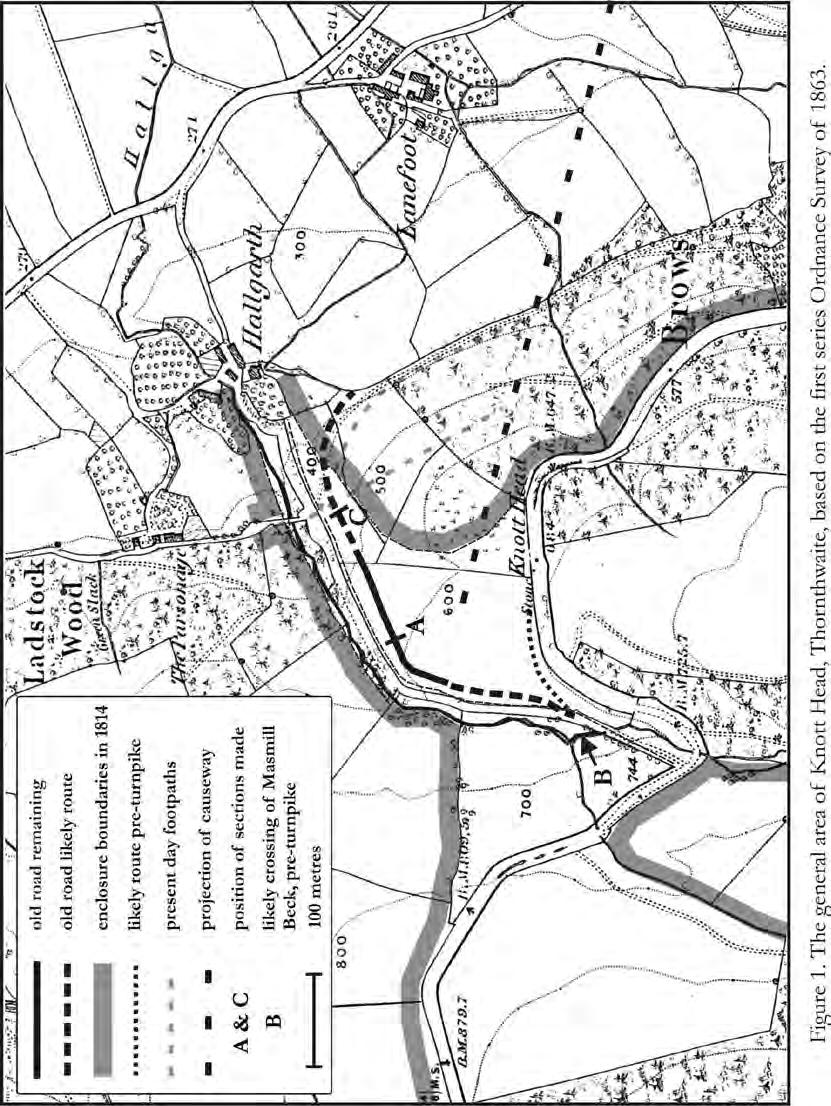
1 An old road to Knott Head from Thornthwaite BY DEREK DENMAN In 1998 a group of members of the Lorton & Derwent Fells Local History Society made excavations, with the consent of the landowner, on an old disused road which ascends the fell-side between Thornthwaite and Knott Head. 1,2 The group had been established to study and seek Roman roads in Lorton Vale, based on the common understanding that the Whinlatter Pass was once on the route of a Roman road; for example as proposed and surveyed by Allan in The Roman route across the northern Lake District; Brougham to Moresby. 3 Having been unable to find clear physical evidence of such a road at the western end of the pass, the group turned its attention to the eastern end, and the relationship of the ascent with the closest piece of proven Roman road; the old causeway by Braithwaite railway station reported by Bellhouse in these Transactions in 1954 and ,5 The group found a long disused, unreported old road to Knott Head, consistent with the conjectural route proposed by Bellhouse. This paper reports and discusses the findings. Location and context of the road. Figure 1 provides a composite map of the area based on the first edition six inches to one mile ordnance survey of This map has been annotated with features and boundaries relevant to the road and the excavations made. Where it is shown as a full line, from GR to GR , the road is a clear and distinct terrace-way, climbing the fell side to the south of the valley cut by Masmill Beck. The map shows the current route of the Whinlatter Road, turnpiked under an act of 1761, which runs between Braithwaite and Lorton, plus the Hallgarth Road, running alongside and mostly to the south of Masmill Beck from the turnpike to Hallgarth, as it was specified to be built in the enclosure act of ,7 Immediately to the south of the Hallgarth road is a wall enclosing the commons allotments, which contain the old road. The map is annotated with the extent of the ancient enclosures at 1814, where ancient in enclosure terms means at least 30 years before the Act, or 1784 in this case. To the North is the old Ladstocks Enclosure. The more recent enclosure on the fell-side to the South East appears to be later, the older fence being at the break of slope. The old road is shown in no known maps or descriptions except possibly one. In James Clarke s survey of the Lakes of 1787, the map of this area, not drawn to a measured survey, shows a road from the turnpike to Lonin-foot, or Lanefoot, between ancient enclosures. 8 Though there was a road from this station to Thornthwaite in at Lonin-foot, yet it is so steep you cannot ride down it. 9 Therefore it appears that a lane from the Whinlatter road went to Lanefoot before the commons enclosure but was replaced by the Hallgarth road, though no mention of the old road is made in the award. 1
2 2
3 Description of the road and excavations. The land containing the road was used as common grazing before enclosure, and remains unimproved grazing today; with bracken, gorse and a scattered planting of larch adorning its higher parts. The cover of the road, from silting and vegetation, suggests that it has been out of use for many decades, but not many centuries. In most of the part shown by a full line, the road surface has a consistent width of 4m and is constructed as a curving terrace. The route of the road appears to have been chosen to avoid the steeper slope of the fell further to the south; keeping its slope within 25%. The terrace-way was sectioned at point A, GR , and evidence of a properly constructed road was found, as illustrated in figure 2. The slate bedrock had been cut away as necessary to maintain the steady line and slope of the road. The terrace had been built out, retained by a curb of large stones, and finished at a width of 4m. The part of the road shown as dashed and becoming gradually more conjectural above the terrace is less steeply graded and on transversely level ground, with little material covering the bedrock. On the southern side of Masmill Beck at point B, GR , a number of large flat glacial boulders were found, placed to form a dry, solid approach to the beck. This crossing was consistent with both an extrapolation of the line of the old road, and also of a second old fell road, shown dotted, that merged with the current turnpike at Knott Head. This suggested that, before the turnpike was built, both the Whinlatter road and the Thornthwaite branch to Lanefoot might have crossed the beck at point B. The land across the beck at point B, an enclosure allotment, has been extensively disturbed by forestry. A section made at point C, GR , where the surface suggested a possible agger, showed no sign of purposeful construction. No hard base, indications of metalling or lateral ditches could be found. However, this general area contains numerous uninvestigated linear features in the ground, consistent with its earlier use as the access point to Thornthwaite common for many centuries. Interpretation It is likely that the most recent use of the old road was to connect Thornthwaite with the Whinlatter road both before and after that road was turnpiked in the 1760s. As evidenced by Clarke in 1787, the road then started at Lonin-foot or Lanefoot, rather than Hallgarth. It was replaced by the Hallgarth road after Prior to the construction of the turnpike, the Whinlatter road, which is attested in seventeenth century manorial records as a highway, may well have met the Thornthwaite road at a crossing point B on Masmill Beck. 10 The major interest in the old road is as a possible part of a Roman road from Keswick to Papcastle over the Whinlatter Pass. Although that road is 3
4 commonly accepted to have existed, as part of a route from Maryport to Brougham and the Stanegate, examination of the literature shows the physical evidence to be lacking or unproven. The necessary Roman fort at Keswick has neither been found nor located, and the only proven piece of Roman road between Keswick and the fort Derventio at Papcastle is the causeway passing between Derwentwater and Bassenthwaite Lake, found near Braithwaite station, west of the Derwent and Newlands Beck crossings. 11 The existence of this road, 4
5 of another from Caermote, near Bothel, passing along the east side of Bassenthwaite Lake, and their conjunction near Keswick, is rooted in the conjecture of Horsley, 1732, and developed in the other works cited in this paper. 12 The importance of a Roman attribution to the origin of the old road, would lie in its confirmation that a Roman road did cross the fells via the Whinlatter Pass. The road does not have a design and construction that is diagnostically Roman, but it is consistent with Roman practice for a minor road in that type of terrain. The route is also fully consistent with the conjectural line of ascent proposed by Bellhouse, based on the alignment of the causeway with the viewpoint at Knott Head. 13 Furthermore, it has been shown to be an old road, neither a turnpike nor an enclosure road nor associated with any known serious mining or quarrying. It appears too well surveyed, designed and made for a medieval or early modern purpose. While it is of course impossible to eliminated the effect of a thousand years of history on this piece of land, it is credible that this section of road could have Roman origins. It provides, taken with the causeway, the best evidence so far that a Roman road crossed the Whinlatter Pass. 1 The members of the group were: the late Ken Deas, Ruth Deas, Derek Denman, Anne Flower, Robert Flower, Michael Grieve, Adrian Head, Joan Head, Daphne Holbrook, Alan Norris. The group had the advice and involvement of Alan Richardson in this area. 2 The land containing the road remains is privately owned and not accessible under the right to roam legislation 3 Allan, Martin. The Roman route across the northern Lake District: Brougham to Moresby. CNWRS, Lancaster Bellhouse, Richard. The Roman road from Old Penrith to Keswick and beyond. Transactions CWAAS 1954 pp Bellhouse Richard. Roman roads in Cumberland. A note on some discoveries in 1959 Transactions CWAAS 1960 p.25 6 Williams, L A. Road Transport in Cumbria in the nineteenth century. Allen & Unwin, London 1975, Appendix A. 7 CRO/C/QRE/1/10 8 Clarke, James. A survey of the lakes of Cumberland, Westmorland and Lancashire. Clarke, London 1787, plate 7. 9 Clarke, James 1787, p CRO/W/D/Lec.85 Derwentfells court leet, 31 st March Turmen of Braythwait & Cowdle complaineth of the Township of Lorton for a peece of high way not sufficient. 11 Bellhouse 1960 p Horsley, John. Britannia Romana: or the Roman antiquities of Britain. Osborn& Longman. London 1732, pp Bellhouse 1954, figure facing page 20. This paper was printed in Transactions CWAAS Vol.VII 2007 pps
A brief history of Embleton and Wythop. by Walter Head and Derek Denman Embleton Community Hall, 15 April
 A brief history of Embleton and Wythop by Walter Head and Derek Denman Embleton Community Hall, 15 April 2015 1 Structure of presentations Derek Denman: An outline of the history of Embleton and Wythop
ISOM & ISSOM forbidden symbol comparison
 & forbidden symbol comparison Forbidden symbols and their relatives Symbol 2000 (Long, Middle) 2007 (Sprint) 201 Impassable cliff An impassable cliff, quarry or earth bank (see 106) is shown with a 0.35
4. Bronze Age Ballybrowney, County Cork Eamonn Cotter
 4. Bronze Age Ballybrowney, County Cork Eamonn Cotter Illus. 1 Location map of the excavated features at Ballybrowney Lower (Archaeological Consultancy Services Ltd, based on the Ordnance Survey Ireland
5 MAP SPECIFICATION FOR SKI-ORIENTEERING
 5 MAP SPECIFICATION FOR SKI-ORIENTEERING 5.1 General Maps for ski orienteering are based on the specifications for foot-orienteering maps. However in order to meet the specific requirements put on the
FOUNDATIONS OF ARCHAEOLOGY A WALK IN VERNDITCH CHASE
 FOUNDATIONS OF ARCHAEOLOGY A WALK IN VERNDITCH CHASE 1. A Tale of two Long Barrows Long barrows were constructed as earthen or drystone mounds with flanking ditches and acted as funerary monuments during
Gorse Stacks, Bus Interchange Excavations Interim Note-01
 Gorse Stacks, Bus Interchange Excavations 2015 Prepared for: Cheshire West & Chester Council Interim Note-01 1 Introduction & Summary Background Since c. 2000 investigations associated with redevelopment
Looking north from the SW shieling site with Lub na Luachrach in the foreground
 Looking north from the SW shieling site with Lub na Luachrach in the foreground Upper Gleann Goibhre - Shieling sites Two shieling sites in the upper reaches of the Allt Goibhre were visited and recorded
Afon Adda Refurbishment Bangor
 Afon Adda Refurbishment Bangor Archaeological Assessment Revised Report GAT Project No. 1876 Report No. 628 April 2006 Ymddiriedolaeth Archaeolegol Gwynedd Gwynedd Archaeological Trust Craig Beuno, Ffordd
Walk around Bassenthwaite
 Walk around Bassenthwaite This is a fabulous walk, not least because it takes in a good pub halfway round! We park near St Bega s church which is a lovely little church, built on the shores of Bassenthwaite
Visual and Sensory Aspect
 Updated All Wales LANDMAP Statistics 2017 Visual and Sensory Aspect Final Report for Natural Resources Wales February 2018 Tel: 029 2043 7841 Email: sw@whiteconsultants.co.uk Web: www.whiteconsultants.co.uk
Chiselbury Camp hillfort
 Chiselbury Camp hillfort Reasons for Designation Large univallate hillforts are defined as fortified enclosures of varying shape, ranging in size between 1ha and 10ha, located on hilltops and surrounded
Baggy Point, Croyde, North Devon
 Baggy Point, Croyde, North Devon A walk using the South West Coast Path that is likely to be suitable for people with impaired mobility or with a pushchair, wheelchair, or mobility scooter. The Coast Path
General Summer and Winter Views
 ENVIRONMENTAL INFORMATION REPORT VOLUME 4 APPENDIX 11. 2 General Summer and Winter Views Table of Contents Section APPENDIX 11.2 Page 1 General Views... 1-1 Tansy Lane, Portishead... 1-2 Galingale Way,
United States Department of the Interior National Park Service. Boundary Expansion Listed in National Register January 11, 2017
 NPS Form 10900-a (Rev. 8/2002) OMB No. 10240018 United States Department of the Interior National Park Service Boundary Expansion Listed in National Register January 11, 2017 National Register of Historic
CWMGIEDD FROM ABERCRAVE
 Abercrave to Cwmgiedd Walk Page 1 Starting from The Abercrave Inn. Grid Ref: SN 824128 From the Abercrave Inn, an 11.3km (7 miles) walk to the foothills of the Cribarth Mountain, then through forest to
Survey of Deadwater Fell and Peel Fell
 4 December 2014 Survey of Deadwater Fell and Peel Fell Team: John Barnard, Chris Crocker, Richard Cooper and Graham Jackson 1) Introduction Deadwater Fell (Hill 3542, Section 33, OS 1:50000 Map 80, OS
A Possible Roman Road Discovered in Lanarkshire
 A Possible Roman Road Discovered in Lanarkshire In the eighteenth century, William Roy documented the Roman road network that provided communication between the Castledykes fort (near Carstairs, Lanarkshire)
Lake Wissota Access Locations within the LaFayette Township. By Chad Martin
 Lake Wissota Access Locations within the LaFayette Township By Chad Martin Anson/ Wissota Access Point # 1 Road: 195 th St. Associated Fire Numbers: 13294 Defining Characteristics: Forested from road
Following the initial soil strip archaeology is sprayed up prior to planning and excavation
 Barton Quarry & Archaeology Over the past half century quarries have been increasingly highlighted as important sources of information for geologists, palaeontologists and archaeologists, both through
HARDMOORS ROUTE DESCRIPTION
 HARDMOORS 60 2016 ROUTE DESCRIPTION RACE START (GUISBOROUGH) - CHECKPOINT 2 (SALTBURN) DISTANCE 9 MILES CUT OFF TIME 1030 GRID REF OS 666 208 1. Leaving the Sea Cadets Hall, turn left onto the road and
APPENDIX D: SUSTAINABLE TRAIL DESIGN. APPENDICES Town of Chili Parks and Recreation Master Plan Update
 APPENDIX D: SUSTAINABLE TRAIL DESIGN APPENDICES Town of Chili Parks and Recreation Master Plan Update Sustainable Trail Construction Sustainable trails are defined by the US Forest Service as trails having
HILL-FORTS OF THE INNER TAY ESTUARY PERTH. Phase One PERTH AND KINROSS. Archaeological Survey Report. Oxford Archaeology North.
 HILL-FORTS OF THE INNER TAY ESTUARY PERTH PERTH AND KINROSS Phase One Archaeological Survey Report Oxford Archaeology North September 2012 Issue No: 2012-13/11322 OAN Job No: L10492a NGR: NO 182 153, NO
Eglwyseg Mountain a landscape of prehistoric cairns and later industry
 Eglwyseg Mountain a landscape of prehistoric cairns and later industry Walk Information: Maps: OS Explorer 256 Distance: 5.3 miles / 8.5 kilometres (linear) or up to 9.6 miles / 15.5 kilometres (circular)
Appendices A (Our ambition for nature (A3 plan) and further information)
 and further information)") Appendices A (Our ambition for nature (A3 plan) and further information) Penny Hill Farm Nature Conservation vision Key: Tenancy boundary Meadow restoration & Mowing/meadow F33 Mowing/meadow Progress towards
Appendices A (Our ambition for nature (A3 plan) and further information) Penny Hill Farm Nature Conservation vision Key: Tenancy boundary Meadow restoration & Mowing/meadow F33 Mowing/meadow Progress towards
Ammonite Falls Descent
 Trail Benson Creek Falls ABOUT THE SITE Today, people descend a steep ravine to reach the base of Ammonite Falls, which is one of the most soughtafter views in the park. Over the past several years, awareness
Open water swimming near Derwentwater Independent Hostel
 Open water swimming near Derwentwater Independent Hostel I recommend that you use Ordnance Survey Explorer maps (1:25 000) to find the swimming locations and plan your walks. OL4, OL5, and a tiny section
Land off Birdie Way, Rush Green, Hertford, Hertfordshire
 Land off Birdie Way, Rush Green, Hertford, Hertfordshire An Archaeological Evaluation for Bride Hall Development Limited by Sarah Coles Thames Valley Archaeological Services Site Code RGH00/ 01 January
Sainsburys Store, Mere Green Road, Sutton Coldfield, Birmingham, B75 5BT
 Committee Date: 7/0/013 Application Number: 013/04/PA Accepted: 1/04/013 Application Type: Variation of Condition Target Date: 1/07/013 Ward: Sutton Four Oaks Sainsburys Store, Mere Green Road, Sutton
Just under a mile from Cawfields car park where the walk begins is Great Chesters Roman Fort. It is behind the tree, looking from the west.
 Tynedale U3A Hadrian s Wall Group Cawfields to Birdoswald Just under a mile from Cawfields car park where the walk begins is Great Chesters Roman Fort. It is behind the tree, looking from the west. Great
Limestone terraces (in the distance) and woodland on hills in the Upper Wharfedale valley
 and woodland on hills in the Upper Wharfedale valley") GRASSINGTON North Yorkshire from www.discoverbutterflies.com the website for the book Discover Butterflies in Britain D E Newland 2009 Limestone terraces (in the distance) and woodland on hills in the
GRASSINGTON North Yorkshire from www.discoverbutterflies.com the website for the book Discover Butterflies in Britain D E Newland 2009 Limestone terraces (in the distance) and woodland on hills in the
Foreword. Loch Ness from the summit of the High Route
 Foreword 4 The Great Glen Way runs for just over 77 miles (125 km) from Fort William to Inverness. It starts beside Britain s highest mountain, Ben Nevis; follows its greatest geological fault along the
INTRODUCTION. Mailing address: Burke County Community Development Attn: Tim Johnson P. O. Box 219 Morganton, NC
 REQUEST FOR QUALIFICATIONS: PROFESSIONAL, EXPERIENCED TRAIL BUILDERS FOR THE CONSTRUCTION OF THE FONTA FLORA STATE TRAIL LAKE JAMES SECTION BURKE COUNTY COMMUNITY DEVELOPMENT INTRODUCTION Burke County
Non-motorized Trail Plan & Proposal. August 8, 2014
 Town of Star Valley Ranch, Wyoming and the Star Valley Ranch Association in partnership with the USDA Forest Service, Bridger-Teton National Forest, Greys River Ranger District Non-motorized Trail Plan
 TOURS The Lake District 2018-2019 Get off the beaten track 015394 45161 www.mountain-goat.com +44 (0)15394 45161 1 Welcome to the Lake District Established 1972, Mountain Goat tour the Lake District, Yorkshire
PSP 75 Lancefield Road. Northern Jacksons Creek Crossing Supplementary Information
 PSP 75 Lancefield Road Northern Jacksons Creek Crossing Supplementary Information September 2017 The northern crossing of Jacksons Creek proposed within the Lancefield Road PSP is a key part of the ultimate
Ferryhill a short history
 Ferryhill a short history by Jane Hatcher General Background History The place name has nothing to do with ferries! It comes from the Old English word fergen or hill, and means a settlement on a hill (1).
TREK THE ROCKIES ABOUT THE CHALLENGE TREK THE ROCKIES FOR HIGHLAND HOSPICE CANADA TREK DEMANDING
 TREK THE ROCKIES CANADA TREK DEMANDING ABOUT THE CHALLENGE The Canadian Rockies are justifiably world-famous for their magnificent scenery: the combination of impressive, jagged mountains, bright turquoise
Walking Holidays in Britain s most Beautiful Landscapes
 Walking Holidays in Britain s most Beautiful Landscapes Cumbria Way The Cumbria Way bisects Cumbria from the market town of Ulverston, near the coast of Morecambe Bay in the south, to the historic city
Have we got views for you...
 From tob tosee Your Scenic Guide to Services 77 & 77 Keswick. Whinlatter. Buttermere. Grange. Keswick The Honister ambler ride to heart of the fells Have we got views for you... Lakeland see and explore...
KP Lasnaya 1 River
 KP 370.2 Lasnaya 1 River The Lasnaya 1 River crossing is protected by Reno mattings and a gabion wall on the north bank (Photo 1). The south bank consists of natural river gravel deposits on top of Reno
Henderson Mess, RAF Halton, Buckinghamshire
 Henderson Mess, RAF Halton, Buckinghamshire An archaeological watching brief for Stepnell Ltd by Stephen Hammond Thames Valley Archaeological Services Ltd Site Code RHA03/85 October 2003 Summary Site name:
The Atlas of Hillforts of Britain and Ireland. Hillfort survey notes for guidance
 The Atlas of Hillforts of Britain and Ireland Hillfort survey notes for guidance The collection of surveys for the Atlas is now finished but you can use this form and the accompanying Notes for Guidance
SIGNATURE ELEMENTS BICYCLE RACKS & FENCING NSSD HWY. 61 CAIRN & TRAIL SIGNS INTERPRETIVE KIOSK
 SIGNATURE ELEMENTS BICYCLE RACKS & FENCING NSSD HWY. 61 CAIRN & TRAIL SIGNS INTERPRETIVE KIOSK 77 SIGNATURE ELEMENTS BICYCLE RACKS & FENCING: A kiosk, signs, fencing, and bike racks were designed as a
2. Presentation from Rob Kitchen- Waste & Recycling Officer, Allerdale Borough Council
 Notes of the Derwent 7 meeting held on 15 th December 2014 in the Keswick Quaker Meeting House at 19:00. Present: Geoff Davies (In the Chair) Carter- Derwent 7 Administrator Richard Keeley- Above Derwent
Beamers Trail. Walk No.1. 6 miles. (easy with some moderate ascents and descents)
") Beamers Trail Walk No.1 6 miles (easy with some moderate ascents and descents) 1 BEAMERS TRAIL 6 miles (easy with som WALK The Warpers Trail forms part of the long distance Witton Weavers Way. This is
Beamers Trail Walk No.1 6 miles (easy with some moderate ascents and descents) 1 BEAMERS TRAIL 6 miles (easy with som WALK The Warpers Trail forms part of the long distance Witton Weavers Way. This is
ROUKEN GLEN: BANDSTAND 2015 DATA STRUCTURE REPORT
 ROUKEN GLEN: BANDSTAND 2015 DATA STRUCTURE REPORT Author (s) Ian Hill Editors Report Date June 2015 Working Partners Funders Phil Richardson East Renfrewshire Council East Renfrewshire Council, Heritage
4.1 Landforms. Note: dimensions are specified in mm at the scale of 1: All drawings are at 1:7 500 for clarity only.
 4.1 Landforms Note: dimensions are specified in mm at the scale of 1:15 000. All drawings are at 1:7 500 for clarity only. OM = Outside measure IM = Inside measure CC = Centre to centre 0.2 0.4 OM 0.4
2. STAKEHOLDER FEEDBACK // What We Heard
 1. QUARRY ROAD TRAIL // Welcome to the Information Session PROJECT DESCRIPTION WHY WE ARE HERE Quarry Road Trail is a popular commuter trail and recreational area for Calgarians. 1. To report citizen feedback
VISUAL Impact Assessment
 5.0 Existing Landscape Character TO GOULBURN FEDERAL HIGHWAY 5.1 Landscape Character Units Generally one of the first steps in carrying out a landscape and visual assessment is to identify and map the
Will Huckerby Forest Enterprise Recreation & Communities Manager Julie McMorran Forest Enterprise Recreation Civil Engineer Fiona
 UPAG Site Visit 2017: Ben A an 15 September 2017 Attendees: Will Huckerby Forest Enterprise Recreation & Communities Manager Julie McMorran Forest Enterprise Recreation Civil Engineer Fiona Scottish Natural
ABOVE DERWENT PARISH COUNCIL
 ABOVE DERWENT PARISH COUNCIL Minute s of the Parish Council Meeting held on Wednesday 15 th July 2015 at 7.15.p.m. in the Stair Institute. PRESENT: Councillor Richard Kealey () Chairman Councillors: Don
Railway-Highway Crossing at Grade Regulations: Guidelines for British Columbia s Provincial Heritage Railways
 Railway-Highway Crossing at Grade Regulations: Guidelines for British Columbia s Provincial Heritage Railways SHORT TITLE 1. These Guidelines may be cited as the Railway-Highway Crossing at Grade Guidelines.
Schedule of Planning Applications Committee Date: 23 May Reference: 06/18/0064/F Great Yarmouth Officer: Mr J Beck Expiry Date:
 Schedule of Planning Applications Committee Date: 23 May 2018 Reference: 06/18/0064/F Great Yarmouth Officer: Mr J Beck Expiry Date: 24-04-2018 Applicant: Proposal: Site: Mr Mavroudis Clear weather hoardings
Friends Meeting House, Tottenham. 594 Tottenham High Road, London, N17 9TA. National Grid Reference: TQ Statement of Significance
 Friends Meeting House, Tottenham 594 Tottenham High Road, London, N17 9TA National Grid Reference: TQ 33918 90370 Statement of Significance The meeting house is an unremarkable structure of the 1960s,
1 INFORMATION REQUIREMENTS
 1 INFORMATION REQUIREMENTS 1.1 BACKGROUND 2 1.2 WHAT IS THE DISTRICT PLAN 3 1.3 DISTRICT PLAN STRUCTURE 4 1.4 HOW TO USE THE DISTRICT PLAN 5 1.5 STRATEGIC FRAMEWORK 6 Whanganui District Plan (15 January
Arrangements for the delivery of minor highway maintenance services by Town and Parish Councils
 Arrangements for the delivery of minor highway maintenance services by Town and Parish Councils Cabinet Date of Meeting 8 March 2017 Officer Cllr Peter Finney, Cabinet Member for Environment, Infrastructure
The Hallams Blackheath Surrey
 The Hallams Blackheath Surrey The Hallams Littleford Lane Blackheath Surrey An exceptional opportunity in a stunning rural position Land: In all about 5 hectares (12.4 acres) Buildings: In all about 1,385
HARDMOORS 55 RACE ROUTE 2018 HELMSLEY - GUISBOROUGH
 HARDMOORS 55 RACE ROUTE 2018 HELMSLEY - GUISBOROUGH HELMSLEY - CHECKPOINT 1 (WHITE HORSE) 1. Leave RACE START, continue ahead on road (Baxtons Sprunt) At crossroads turn right down Canons Garth eventualy
North & West Melbourne Precinct HO3. March 2015
 North & West Melbourne Precinct HO3 March 2015 Local Heritage Planning Policy Review Statements of Significance Melbourne s Local Heritage Planning Policy Review project includes the preparation of statements
An Assessment of Lower Boddington
 W An Assessment of Lower Boddington Design and Conservation Team Reviewed Winter 2017 Contents Introduction... 2 Origins and Archaeology... 3 Historic Development... 3 Plan Form... 3 Space and relationship
Archaeological Watching Brief on land at Alpha, Gore Road, Eastry, Kent July 2010
 Archaeological Watching Brief on land at Alpha, Gore Road, Eastry, Kent July 2010 SWAT. Archaeology Swale and Thames Archaeological Survey Company School Farm Oast, Graveney Road Faversham, Kent ME13 8UP
Middle Row: Part of a Georgian Industrial Settlement in Cark in Cartmel, Cumbria Les Gilpin
 Middle Row: Part of a Georgian Industrial Settlement in Cark in Cartmel, Cumbria Les Gilpin The Georgian rows of of High Row and Low Row which sit alongside ' Cark Beck' (river Eea) in the hamlet of Cark
UNIVERSITY OF LANCASTER ARCHAEOLOGY FORUM. 3 March 2007
 UNIVERSITY OF LANCASTER CENTRE FOR NORTH-WEST REGIONAL STUDIES ARCHAEOLOGY FORUM 3 March 2007 The Carlisle Millennium Excavations - John Zant From 1998 to 2001 a major programme of archaeological excavation
Holyport Manor Special School, Highfield Lane, Cox Green, Maidenhead, Berkshire
 Holyport Manor Special School, Highfield Lane, Cox Green, Maidenhead, Berkshire An Archaeological recording action For CgMs Consulting by Jennifer Lowe Thames Valley Archaeological Services Ltd Site Code
BHS ADVICE ON Dimensions of Width, Area and Height
 BHS ADVICE ON Dimensions of Width, Area and Height 2 In providing specifications for equestrian ways and facilities, The British Horse Society considers all equestrian users, which may result in a high
ANTONINE WALL - BARHILL
 Property in Care (PIC)no: PIC168 Designations: Scheduled Monument (SM90008) Taken into State care: 1960 (Guardianship) Last reviewed: 2005 HISTORIC ENVIRONMENT SCOTLAND STATEMENT OF SIGNIFICANCE ANTONINE
Breeze Hill Portinscale, Keswick, Cumbria, CA12 5RW. The Lake District National Park
 Breeze Hill Portinscale, Keswick, Cumbria, CA12 5RW The Lake District National Park The River Derwent Breeze Hill, Por tinscale THE LAKE DISTRICT Page 4 of 12 Overview A five bedroom detached property
Scenic Railway to Ruined Castle
 Scenic Railway to Ruined Castle 7 hrs 30 mins 12.4 km Return Hard track 4 963m This is a very popular, full day walk, in the Katoomba Area, offering great views of the valley. The walk follows the edge
The Old Shire Horse Centre, Bath Road, Woolley Green, Maidenhead, Berkshire
 The Old Shire Horse Centre, Bath Road, Woolley Green, Maidenhead, Berkshire An Archaeological Watching Brief For Mr Derek Chesterman by Andrew Mundin Thames Valley Archaeological Services Ltd Site Code
Section 3-04 Cross Sectional Elements TABLE OF CONTENTS. INTRODUCTION...3 General...3 Exhibit 1-Cross-Sectional Elements...3
 Section 3-04 Cross Sectional Elements TABLE OF CONTENTS INTRODUCTION...3 General...3 Exhibit 1-Cross-Sectional Elements...3 CROSS-SECTIONAL ELEMENTS...3 Traveled Way...3 Shoulder...3 Surfacing Taper...3
7 Knowsley. 7.1 Location and administration
 7 Knowsley 7.1 Location and administration The Metropolitan Borough of Knowsley is a metropolitan borough of Merseyside, covering some 86.17km 2. Knowsley comprises a belt of small towns, suburbs and countryside,
THE PROPOSED NETWORK RAIL (ESSEX AND OTHERS LEVEL CROSSING REDUCTION) ORDER DEPARTMENT FOR TRANSPORT REFERENCE: TWA/17/APP/05
 ORDER DEPARTMENT FOR TRANSPORT REFERENCE: TWA/17/APP/05") OBJ/148/ W 031 E20 SNIVELLERS THE PROPOSED NETWORK RAIL (ESSEX AND OTHERS LEVEL CROSSING REDUCTION) ORDER PUBLIC INQUIRY, 18 OCTOBER 2017 DEPARTMENT FOR TRANSPORT REFERENCE: TWA/17/APP/05 OBJECTION BY
OBJ/148/ W 031 E20 SNIVELLERS THE PROPOSED NETWORK RAIL (ESSEX AND OTHERS LEVEL CROSSING REDUCTION) ORDER PUBLIC INQUIRY, 18 OCTOBER 2017 DEPARTMENT FOR TRANSPORT REFERENCE: TWA/17/APP/05 OBJECTION BY
GCSE Geography A. Mark Scheme for June Unit A732/02: Geographical skills (Higher Tier) General Certificate of Secondary Education
 General Certificate of Secondary Education") GCSE Geography A Unit A732/02: Geographical skills (Higher Tier) General Certificate of Secondary Education Mark Scheme for June 2016 Oxford Cambridge and RSA Examinations OCR (Oxford Cambridge and RSA)
GCSE Geography A Unit A732/02: Geographical skills (Higher Tier) General Certificate of Secondary Education Mark Scheme for June 2016 Oxford Cambridge and RSA Examinations OCR (Oxford Cambridge and RSA)
Tiger Mountain State Forest:
 98 60 hikes within 60 miles: SEATTLE 20 Tiger Mountain State Forest: West Tiger Mountain Three Loop i KEY AT-A-GLANCE INFORMATION Length: 5.1 miles round-trip Configuration: Loop Difficulty: Moderate difficult
In September, 1966, an
 ANNE S. ROBERTSON, D LITT THE ROMAN CAMP(S) ON HILLSIDE FARM, DUNBLANE, PERTHSHIRE This paper is published with the aid of a grantfrom H.M.Treasury In September, 1966, an emergency excavation was begun,
FORT YORK PEDESTRIAN & CYCLE BRIDGE
 FORT YORK PEDESTRIAN & CYCLE BRIDGE November 2006 urban design landscape architecture architecture DTAH This is a new concept for the Fort York Pedestrian and Cycle Bridge linking Stanley Park (South)
LOW BORROWBRIDGE: Continuing investigations at the Roman site in the Lune Gorge
 LOW BORROWBRIDGE: Continuing investigations at the Roman site in the Lune Gorge By Graham Hooley, Jan Hicks and Jackie Hooley 1 Summary Following two seasons of excavations on a building to the south of
Trail Phasing Plan. Note: Trails in the Clear Creek Canyon area (Segments will be finalized in the future to minimize wildlife impacts
 Note: Trails in the Clear Creek Canyon area (Segments 2 5 and a future JCOS connection) will be finalized in the future to minimize wildlife impacts Trail Phasing Plan P Parking 3 Easy Trail Intermediate
PLEASE JOIN US & TELL YOUR FRIENDS
 INVITATION TO WALK OR RUN ONE OF THE PATTERDALE PARISH BOUNDARY WALKS SATURDAY 1 July 2017 IN AID OF AND CHURCH 1. The Full Monty - The whole Patterdale Parish Boundary is about 30 miles long and has about
Mountain Valley Pipeline, LLC Mountain Valley Pipeline Project Docket No. CP
 16. Prior to construction, Mountain Valley shall file with the Secretary, for review and approval by the Director of OEP, a segment-specific construction and operation access plan for the area between
CHESHIRE HISTORIC TOWNS SURVEY
 CHESHIRE HISTORIC TOWNS SURVEY Eddisbury Archaeological Assessment 2003 CHESHIRE HISTORIC TOWNS SURVEY Eddisbury Archaeological Assessment 2003 Environmental Planning Cheshire County Council Backford Hall
Public Notice ISSUED: December 10, 2018 EXPIRES: January 9, 2019
 APPLICANT: REFER TO: St. Louis and Lake Counties Regional Rail Authority 2018-01942-ARC Public Notice ISSUED: December 10, 2018 EXPIRES: January 9, 2019 SECTION:404 - Clean Water Act 1. APPLICATION FOR
Lancaster Castle THE CASTLE STUDIES GROUP JOURNAL NO 26:
 Lancaster Castle. The Henry IV gatehouse from the south-east. The C15 gatehouse subsumes a C12/13 stone gateway, observable inside the gate passage beyond the portcullis. The lower level loops originally
MiSP Topographic Maps Worksheet #1a SLOPE AND TOPOGRAPHIC CONTOURS
 MiSP Topographic Maps Worksheet #1a Name Date Introduction: SLOPE AND TOPOGRAPHIC CONTOURS Topographic contours are shown by lines of different widths. Each contour is a line of equal elevation; therefore,
Gors Lydan barrows and medieval huts
 Walk Information: Maps: OS Explorer 214 Distance: 5.5 miles / 9 kilometres Duration: 4.5 to 5 hours Difficulty: Easy. Good paths and no steep gradients Start and finish: SO 11977545 Walk summary The walk
INTERNATIONAL ORIENTEERING FEDERATION 2010
 INTERNATIONAL ORIENTEERING FEDERATION 2010 Valid from 15 May 2010 1 INTRODUCTION Orienteering is a world-wide sport. A common approach to the interpretation and drawing of orienteering maps is essential
Wessex Archaeology. Little Stubbings, West Amesbury, Salisbury, Wiltshire. Archaeological Watching Brief. Ref:
 Wessex Archaeology Little Stubbings, West Amesbury, Salisbury, Wiltshire Ref: 63280.02 March 2007 LITTLE STUBBINGS, WEST AMESBURY, NR SALISBURY, WILTSHIRE ARCHAEOLOGICAL WATCHING BRIEF Prepared for: P
ANTONINE WALL - DULLATUR
 Property in Care (PIC) ID: PIC172 Designations: Scheduled Monument (SM90017); Taken into State care: 1960 (Guardianship) Last reviewed: 2018 HISTORIC ENVIRONMENT SCOTLAND STATEMENT OF SIGNIFICANCE ANTONINE
Beaver Creek Provincial Park. Management Plan
 Beaver Creek Provincial Park Management Plan 2 Beaver Creek Provincial Park Table of Contents 1. Introduction... 3 2. Park History... 3 3. Park Attributes... 4 3.1 Natural... 4 3.2 Recreational... 4 4.
Exemplar for Internal Achievement Standard Geography Level 1. Conduct geographic research, with direction
 Exemplar for internal assessment resource Geography for Achievement Standard 91011 Exemplar for Internal Achievement Standard Geography Level 1 This exemplar supports assessment against: Achievement Standard
Trail Assessment Report
 Trail Assessment Report Trail Options for the Bear Creek Canyon located in Pikes Peak Ranger District, Pike National Forest and on Colorado Springs Utility Lands Due to the presence of a unique species
Mt Kuring-gai Track to Berowra station
 Mt Kuring-gai Track to Berowra station 4 hrs 15 mins 9.7 km One way Hard track 4 553m This walk explores three valleys, with great displays of wild flowers in spring, and some nice sandstone overhangs.
BISHOPSTONE CIRCULAR WALK
 BISHOPSTONE CIRCULAR WALK 4½ miles (7¼ km) - allow 2 hours (see maps on final pages) Introduction This walk is within the North Wessex Downs Area of Outstanding Natural Beauty and starts from the small,
Excavations in a Medieval Market Town: Mountsorrel, Leicestershire,
 Excavations in a Medieval Market Town: Mountsorrel, Leicestershire, by John Lucas Mountsorrel is situated 12 kms north of Leicester and forms a linear settlement straddling the A6, Leicester to Derby road.
Request for Proposal National Tropical Botanical Garden Lower Limahuli Preserve Emergency Stream Debris Removal
 Request for Proposal National Tropical Botanical Garden Lower Limahuli Preserve Emergency Stream Debris Removal I. Summary of Work Bids are solicited for the emergency removal of debris deposited in the
360 Education + Adventure Reports
 360 Education + Adventure Reports Oughterside Foundation School Dates: 17-19 th September 2014 (2 nights) Group: Oughterside School, Cumbria. 12 pupils from Years 3 to 6. Theme: Team-work and orientation
APPENDIX D2 NOTICE OF INTENT TO DEVELOP IN RELATION TO HERITAGE RESOURCES
 APPENDIX D2 NOTICE OF INTENT TO DEVELOP IN RELATION TO HERITAGE RESOURCES Figure 1: The proposed road shown in broad geographical context of Saldanha Bay. Figure 2: Proposed and existing development
TOWPATH MOWING GUIDELINES
 TOWPATH MOWING GUIDELINES 24 September 2007 CONTENTS Introduction Scope and Status of Guidelines Influences on the Guidelines Health and Safety Biodiversity INTRODUCTION Towpath management is a key issue
Supplemental No. 8 AGENDA ITEM #6.B Distributed 9/19/17
 Supplemental No. 8 AGENDA ITEM #6.B Distributed 9/19/17 18 Sept, 2017 To: Los Altos Hills Mayor Waldeck and Members of the Los Altos Hills City Council Re: 27333 Ursula Lane request for pathway removal
The Lake District Challenge
 The Lake District Challenge Friday 19 - Sunday 21 July 2019 This two day challenge explores the beautiful scenery of the Lake District, and with two different challenge levels, there s something for everyone!