Hampton Township. Community Description
|
|
|
- Margery Sarah Short
- 5 years ago
- Views:
Transcription

1 Hampton Township Community Description Hampton Township is located in southern Bay County, east of Bay City and Essexville. It contains approximately 9 miles of Saginaw Bay shoreline and 1.5 miles of Saginaw River frontage. The eastern portion of the Township is known for its rich agricultural lands. The western portion of the township is more densely populated resembling a suburban setting. M-25 is the major roadway in the Township. It runs east to west across the southern portion of the Township and it carries the majority of the traffic in and through the community. According to the 2000 Census, Hampton Township has a population of 9,902. The 2006 popula- tion estimate for Hampton Township is 9,834, which shows a slight population decrease. Similar population decreases are estimated for most of the other communities in Bay County. 74
2 Administrative Structure The Harnpton Township Recreation Committee is responsible for the parks and recreation function in Hampton Township. They are a committee created by the Hampton Township Board. The committee is comprised of Hampton Township Board members. Currently, the entire Hampton Township Board makes up the Committee. The ten member Department of Public Works Staff is responsible for operating and maintaining the parks in Hampton Township. Additionally, a full time manager is hired for the Finn Road Park during the summer months. Hampton Township Parks and Recreation Organizational Chart Hampton Charter Township Board of Trustees Hampton Township Parks Committee I 1 Hampton Township DPW Staff Finn Road Park Manager Relationships with other agencies Hampton Township has a good working relationship with the Essexville-Hampton School District in terms of parks and recreation facilities. The Hampton Township DPW staff grooms the four ball diamonds at Verellen School for the Little League program. They also maintain the fields at Pondside Park for practice fields. The school district has used Pondside Park for High School Cross-Country meets. Hampton Township has representation on the Bay County RiverwaWRailtrail Committee. This committee is an initiative of the Bay Area Community Foundation and it deals with issues relating to operating, maintaining, and improvinglextending the existing RivenvalklRailtrail. The group focuses on visioning and fundraising as well. Membership includes representatives from various governmental units, governmental agencies (i.e. Road Commission, Bay County Transportation Planning Department), the community at-large and the Bay Area Community Foundation. 75
3 Budgets The sources of funding for parks and recreation in Hampton Township are the Township General Fund, campground fees, Finn Road Boat Launch fees, and pavilion rentals. The current and next year parks and recreation budgets are shown below ,. -. HAMPTON TOWNSHIP PARKS AND RECREATION BUDGETS,.? A -,. " ,. "C-. - Operation & Maintenance '>*, - - *- " - - ('?*--, -.."%r* * I, - -, - A -- $1 04,686 76,925 '. Programming (leagues, special events, etc.) #.,<, Recreation Inventory Hampton Township currently owns six recreational facilities. A seventh parcel at the end of Callahan Road has been acquired by the Township but has not yet been developed. The planning consultant visited each park facility in Hampton Township to complete the inventory below. AcreageIDistance 1 mile 6 acres 30 acres Local Neighborhoods Service Area Entire County Entire Township within 2 miles,. - '-3 Ball Diamond 1 1, 2 Multi-use Path Yes, 10' wide *..,. -., i Pavilion! 2 * I Tennis Courts 4 (lighted) Basketball Court 1 I2 1 Picnic Area Yes Playfield (open space) Yes Other ' ~enchks- ~rills, '~orseshoes Yes ' pond 76
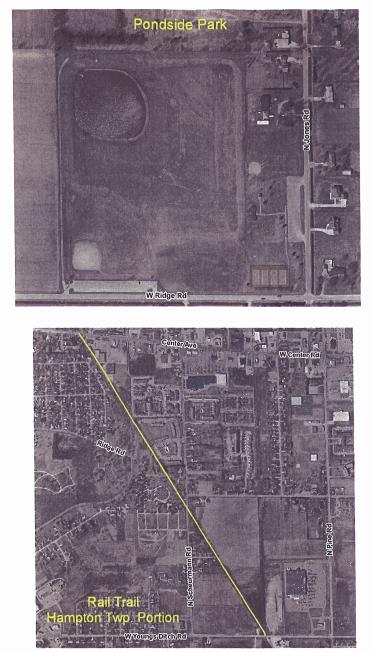
4 HAMPTON TOWNSHIP RECREATION INVENTORY (cont.).,......,.<--,+.'.n.. "- ;;..* ,/., <, :.:!:.?., fi,i"& Riioad'; i; c.?j-g"&:&;kg&a-,, ;., ( : '.:y;,;:-,:y?77.y p> y>&tf*.v6fizk-&d-,., :! ~afure Trail i '" ;. 1 Campground..::...,.Park:..,.A,..... r i... Property.. : Park Type* -. Special Use Special Use Park-Trail undevelo~ed ,-,% "',,3.*?r!2-- w.,as-l. x+>., Rmw..'...<y,'. : Ac6agelbistance. ' i - 12 acres -! 3 a h :.. 2 rn~les - ;. Accessibility* tar.?yV7,wmr7i,,..;&~ir," 7z*.,.? I ,.2. 2,.. N.A ; & >:,.'". '.,%....,?' ~,.Y *3<:2%,1 >.>.,,.,<.--.,,,,.<., -aw+q?sq r.,.,..$.&. &%;isi,; \.;..,-,:,:,..,,.,.,.;,.~!,: &,, 4 :..,,,, 7.'...,, - :,.:-..,?. '.,.i&.:.;<.:... :.,;,:;:L.,;..::.,\... =... : m!f~p.pm? Multi-use Path Yes - 5' wide Yes -. -, '..: -".lf. \. "r$7(.'mt;1 : pavilioh ', -'. :. 2 yes.. '.. FV3p".; :*-'.F4417:%.-pp"l!E??m$??.c.c-,rr?mq f ~ v. 6? C a ~?....,..., ' :(i..... ';? <, -,. I... :..'.,., Campground spaces,..,,: , W.->.?FT 8 iyw: 7;-.,-C:.* '.-? frn,:,pb+-. \... "pp" Playground. A.. yes. ; ; ;,F. v. \ :.FTrm'-% e:*i:,:..k).p?zztw~ppq.,.,hm.,,,, P y s 'l.1..t : L Boat Launch Yes Yes Overlook Platform Yes Yes Playfield (open Yes space).... :' saginaw'8ay Access -.. j. yes... :.,.Yes. ::.. Grills, Benches Other Overlook deck "....,... --, % :,.... ry......, Yes. ' ' *See County inventory section for definitions of park type and accessibility. Hampton Township received an acquisition grant in 1997 (TF97-167) for $130,000 for the expansion of Finn Road Park. Aerial views of Ridge Road Park, Pondside Park, Finn Road Park, Jones Road Park and the Rail Trail are included on the following pages. A location map for the parks is included at the end of the Hampton Township section. Comparison to Standards General park guidelines suggest that a community should have five to ten acres of community parkland per 1,000 residents. This suggests that Hampton Township should have between 50 and 99 acres of parkland for its 9,900 residents. Currently, the Township has approximately 54.5 acres of parkland. This indicates that Hampton Township is within acceptable guidelines for parkland. However, there are several reasons whereby this may not be sufficient: Existing land is not sufficient to add new amenities that the citizens desire Certain geographic areas of the township are underserved in terms of park land. There are unique natural resources that the township wishes to preserve and protect. 77

5 s Ros Park Bay County Recreation Plan:
6 79

7 Goals and Objectives Developing goals and ob.jectives is an important part of the recreation planning process. The overall goal of a parks and recreation department is, obviously, to provide recreation opporhlnities for the community and/or region it serves. More specific goals must be based on the demographic characteristics of the population served, the physical and environmental characteristics of the area, and the input of the community. Goals are the broadest level. They are overreaching and general. Objectives carry out the purpose of the goal. The Action Program is the last level and it identifies specific projects and programs. The Action Program can include organizational, staffing, programming, public information, and operation and maintenance actions. The Hampton Township Parks Committee formulated the following goals and objectives based upon the characteristics of the overall community and the input received at the Bay County community input sessions. 80

8 GOAL 1 Provide safe broad community-based recreation opportunities that improve the overall quality of life for all residents of Hampton Township. GOAL 2 Provide recreational opportunities for people with disabilities. Objective: Develop programs for special needs population. Objeciive: Ensure that improvements and upgrades to parks are handicap accessible. GOAL 3 Develop a non-motorized trail network in Hampton Township. Hampton Township currently has two separate trails - the unpaved Nature Trail and a portion of the paved Bay County Railtrail/Riverwalk. Based on community input, the Township would like to expand its trail system and develop a network of trails for residents and visitors. GOAL 4 Acquire more park land as needed and as it becomes available. GOAL S Improve communication with residents regarding parks and recreation facilities and programming. Objective: Improve Township's Parks and Recreation web site to communicate with residents regarding park and recreation. Objective: Develop a brochure that describes the parks in Hampton Township. GOAL 6 Provide recreational facilities that take advantage of the water based natural resources in Hampton Township. Objective: Add shore fishing facilities in Hampton Township. Objective: Develop swimming access points in Hampton Township. 8 1

9 GOAL 7 Provide quality leisure time activities with special consideration given to activities improving health and fitness. Action Plan With goals and objectives in place, Hampton Township was able to develop a 5-year Action w Tennis Courts at Pondside Park Plan to work toward accomplishing the goals and objectives. The Action Plan details the direction the community wishes to take over the next five years in order to maintain and improve the quality and diversity of area park and recreation opportunities. Projects were assigned a priority of one through five with one being most important and 5 being least important. Each action items relates to one or more of the numbered goals fiom the previous section. Potential capital improvements described in this Plan have been established to provide a framework for decision makers and to enable the Township to apply for grant hnding for the proposed projects. 2. Improve tennis courts at Pondside Park. 3. Develop dog walks at Parks. 4. Complete segment of Nature Trail between Jones Road & Wagner Road. 5. Add interpretive signs on Nature Trail. 6. Add a boardwalk through the mud flats for nature observation. 7. Add educational nature programs such as hunting safety and fishing. 8. Improve parking at parks. 9. Begin to develop improvements at Callahan Road end property ,2,3,7 1,2,5 1,2,6, ,2,6 Bay County Recreation Plan:


10 Feb Hampton Twp Park & Trail Locations Map Prod~rced By Bay COUII:~ DeDafln~enr of Envnonmenial Atfalrs & Conimurl~tv Developmnnr. (;IS Ptvgrarn Oala So~rce Bay County GIs Slale of M~chgan CGI DISCLAIMER Jirrs map IS mfe,rted for geee!alaa~armg pu~poses mly TRe in:orrnelron has no1 Ouerl venil&. and was corn~~led from very general~zed lnlormennri arrd therelore SHOULD NOT BE USED FOR ANY SITE SPECIFIC PURPOSES Bay Coilnlv Shab not he responsrble lor any r!!red or consenquenii,?i damage resollir~g horn any use of ihls mfcmrallon Boat Ramps + Railroad - Existing Trails - Streams 8 Drains Local Roads ~ownshii City Boundaries 4 Gdf - Sate Trunklines Schools - Major Roads Sagin,
Portsmouth Township Census the population of Portsmouth Township is 3,619. Bay County Recreation Plan:
 Portsmouth Township Community Description Portsmouth Township is located in the southern Bay County, east of Bay City and south of Hampton Township. The land within the Township is largely agricultural
Chapter eight. Parks and Recreation. Introduction. Crystal Lake Park District
 Chapter eight Parks and Recreation Introduction One of the indicators of quality of life in a city is the parks and recreation system. The City of Crystal Lake is fortunate to have an excellent parks and
City of Haslett. City of East Lansing. City of East Lansing
 Central Park North (Nancy L. Moore Park) Lake Park North Expansion White Park Expansion #2 White Park Expansion #1 County East East Haslett East East TF87-212 Acquisition $90,000.00 Park. TF08-138 Acquisition
Yuba Creek Natural Area Acquisition. Acme Township. Acme Township. TF Acquisition $1,576, Grand Traverse
 Yuba Creek Natural Area TF00-162 $1,576,021.00 in fee simple of 403 acres of critical wetls upl habitat with over 5,000 feet of frontage on Yuba Creek, a tributary to the east arm of Bay. 2000 Petobago
Acquisition in fee simple of approximately one-half acre of property on the shore of Spring Lake to expand the Lakeside Beach Park.
 Lakeside Beach TF00-136 $122,550.00 in fee simple of approximately one-half acre of property on the shore of Spring Lake to exp the Lakeside Beach. 2000 River Ravines TF00-150 $910,000.00 in fee simple
Silver Lake Park An Environmental Jewel for the Citizens of Prince William County
 Silver Lake Park An Environmental Jewel for the Citizens of Prince William County The Prince William Park Authority Mission Statement states: The Prince William County Park Authority will create quality
MASTER PLAN EXECUTIVE SUMMARY
 Biscuit Run State Park Scottsville Road (State Route 20) Charlottesville, VA 22902 Biscuit Run State Park MASTER PLAN EXECUTIVE SUMMARY Department of Conservation and Recreation Division of Planning and
J. Recreation Plan of Conservation and Development. The Town of Hebron. Section 2. Preservation of Unique Assets. 1 P a g e
 The Town of Hebron Section 2 2014 Plan of Conservation and Development Preservation of Unique Assets J. Recreation Open spaces, parks, sports fields, and recreational programs are considered essential
Northeast Quadrant Distinctive Features
 NORTHEAST QUADRANT Northeast Quadrant Distinctive Features LAND USE The Northeast Quadrant includes all the area within the planning area that is east of Interstate 5 and to the north of State Route 44.
Chapter 6. Action Program. Heart of the Lakes Area Recreation Plan
 Heart of the Lakes Area Recreation Plan 1. Design and construct the following trails (please see the following map): a. the Speedway Trail 1) primary pathway the main trail 2) secondary pathway the proposed
Schoolcraft Township is located in northeast Houghton County. A portion of the township borders Keweenaw County and Lake Superior.
 COMMUNITY DESCRIPTION Schoolcraft Township is located in northeast Houghton County. A portion of the township borders Keweenaw County and Lake Superior. The township is largely rural but has one main population
Community Recreation Plan City of Rockford
 Community Recreation Plan City of Rockford 2019-2022 Plan Adopted January, 2019 2019 Draft 12-3-18 Community Recreation Plan 2019-2022 City of Rockford ii Community Recreation Plan 2019-2023 City of Rockford
2. Goals and Policies. The following are the adopted Parks and Trails Goals for Stillwater Township:
 D. PARKS AND TRAILS 1. Introduction Stillwater Township s population is relatively low, with most residents living on rural residences on large lots. The need for active park space has been minimal in
Tahoe Donner Association Public Scoping Meeting DUDEK
 Tahoe Donner Association Public Scoping Meeting DUDEK Introduction Purpose of this Meeting: Solicit feedback and ideas from members, and staff as we begin the Association Master Plan. Association Master
TRUCKEE TAHOE AIRPORT DISTRICT BOARD OF DIRECTOR STAFF REPORT
 AGENDA ITEM: 11 TRUCKEE TAHOE AIRPORT DISTRICT BOARD OF DIRECTOR STAFF REPORT AGENDA TITLE: MEETING DATE: January 24, 2018 PREPARED BY: NTPUD Agency Partnership Opportunity, Multi-Use Trailhead Access
Rating: 5.0 (scale of 1-10)
") 95 Community Trail System Groundcover: 2-metre paved path, 1- metre grass buffer on either side. Location: Fort St. John Ownership: City of Fort St. John Rating: 5.0 (scale of 1-10) Strategic value: Linear
95 Community Trail System Groundcover: 2-metre paved path, 1- metre grass buffer on either side. Location: Fort St. John Ownership: City of Fort St. John Rating: 5.0 (scale of 1-10) Strategic value: Linear
Town of Castle Rock Parks and Recreation 1
 Town of Castle Rock Parks and Recreation 1 The 2018-2020 Strategic Plan will focus on the following items: Neighborhood park planning is the focus of this presentation. Other strategic plan priorities
CHAPTER 5. Chapter 5 Recreation Element
 CHAPTER 5 Recreation Element Chapter 5 Recreation Element The Recreation Element of the Meyers Area Plan is a supplement to the Recreation Element of the TRPA Regional Plan and the El Dorado County General
Public Park System. Township of Derry. Providing natural open space for the recreational use of our residents and guests.
 Township of Derry Public Park System Providing natural open space for the recreational use of our residents and guests. Directory of Recreational Amenities Hershey s Commitment to Recreation Famous candy
1. Overview of Aberdeen Township and Its Waterfront
 Aberdeen 1. Overview of Aberdeen Township and Its Waterfront 1.1 Geographic Overview Aberdeen Township is a suburban township with a land area of 5.45 square miles, with about 2 miles of shoreline along
OAKLAND TOWNSHIP PARKS AND RECREATION MILLAGE RENEWAL AUGUST 2, 2016 BALLOT PROPOSAL QUESTIONS & ANSWERS PULL-OUT SECTION (APRIL 21, 2016)
") OAKLAND TOWNSHIP PARKS AND RECREATION MILLAGE RENEWAL AUGUST 2, 2016 BALLOT PROPOSAL QUESTIONS & ANSWERS PULL-OUT SECTION (APRIL 21, 2016) 2007 2016 Millage Accomplishments Timeline in Pull-out The Mission
OAKLAND TOWNSHIP PARKS AND RECREATION MILLAGE RENEWAL AUGUST 2, 2016 BALLOT PROPOSAL QUESTIONS & ANSWERS PULL-OUT SECTION (APRIL 21, 2016) 2007 2016 Millage Accomplishments Timeline in Pull-out The Mission
Midland County Parks and Recreation Master Plan
 Midland County Parks and Recreation Master Plan 2009-2013 Midland County Parks and Recreation Master Plan: 2009-2013 Midland County Parks and Recreation Commission Resolution recommending adoption by County
Township Superintendent
 EMPLOYMENT OPPORTUNITY Township Superintendent Buena Vista Charter Township Township Superintendent BUENA VISTA CHARTER TOWNSHIP Buena Vista Charter Township, located in Saginaw County, Michigan, strives
Lake Myra County Park. Wake County, North Carolina Community Forum #2 June 12, 2008
 Lake Myra County Park Wake County, North Carolina Community Forum #2 June 12, 2008 Welcome and Introduction Meeting Agenda Welcome Introductions of Project Team Master Plan Process Community Forum #1 Updates
Chapter 2: Summary of Existing Open Space System
 Chapter 2: Summary of Existing Open Space System In 1976, the Wake County Board of Commissioners established the Wake County Parks and Recreation Department in order to provide park facilities and programs
Parks and Recreation Master Plan
 Emerging Themes Parks and Recreation Master Plan City of Mount Dora, Florida September 17, 2018- Revised October 1, 2018 Agenda Welcome & duction Master Plan The Inventory & Existing Community Overview
PAVILION RESERVATIONS
 Reservations may be requested beginning: PAVILION RESERVATIONS The first Monday the PRCS Office is open following January 1st - Residents of the City of Racine The third Monday in March - Non-City of Racine
F. Forest Recreation Management
 F. Forest Recreation Management F.1) Park and Recreation Management F.1.A. Program Overview. The park and recreation program has been in existence since 1980. With ever increasing outdoor recreation demands
Montrose Charter Township Parks & Recreation Master Plan
 Montrose Charter Township Parks & Recreation Master Plan 2014-2018 Adopted February 25, 2014 Montrose Charter Township Parks & Recreation Master Plan 2014-2018 Montrose Charter Township 139 S. Saginaw
NORTH HEMPSTEAD BEACH PARK MASTER PLAN
 NORTH HEMPSTEAD BEACH PARK MASTER PLAN COMMUNITY DESIGN CHARRETTE Supervisor Judi Bosworth Viviana L. Russell Peter J. Zuckerman Angelo P. Ferrara Anna M. Kaplan Lee R. Seeman Dina M. De Giorgio VISIONING
City of Keller Parks and Facilities Inventory
 City of Keller Parks and Facilities Inventory April 2013 1. BEAR CREEK PARK 44 ACRES 1 Basketball Court with 2 goals 4 Drinking Fountains 1 Large Pavilion with 4 picnic tables, electricity and fireplace
Special Council Agenda
 Special Council Agenda The agenda for the Special Meeting of Council of the District of Mission to be held in the Gymnasium of the Leisure Centre, 7650 Grand Street, Mission, British Columbia on March
APPENDIX OFFICIAL MAP ORDINANCE OF HAMILTONBAN TOWNSHIP OFFICIAL MAP NARRATIVE
 APPENDIX A OFFICIAL MAP ORDINANCE OF HAMILTONBAN TOWNSHIP OFFICIAL MAP NARRATIVE INTRODUCTION: The Official Map of Hamiltonban Township has been prepared to identify those lands and features that Hamiltonban
4MRV Parks Master Plan: Site Analysis
 4MRV Parks Master Plan: Site Analysis Lardner/Klein Landscape Architects in association with: RK&K Grimm + Parker Kittelson & Associates Partners for Economic Solutions RIB U.S.Cost Civil Engineering Architecture
M E S T I Z O C U R T I S P A R K
 ARAPAHOE CONNECTION TO BUS ROUTE AT ND AND LAWRENCE, FUTURE LIGHT RAIL STATION LEGEND SOCIAL TRAIL FLAGSTONE PAVING TO RESTORE/MAINTAIN CONCRETE PAVING DIAGONAL CURVILINEAR SOCIAL ROUTE IS OUT OF HISTORIC
Committee. Presentation Outline
 CW-33-15 11/9/2015 Community and Corporate Services Committee November 10, 2015 1 Presentation Outline Background Vision and Objectives Study Process and Timeline Public and Stakeholder Engagement Organization
SAXON HARBOR REDEVELOPMENT SURVEY
 SAXON HARBOR REDEVELOPMENT SURVEY SEPTEMBER, 2016 1,173 RESPONSES 1 BACKGROUND 1. WHAT TYPES OF ACTIVITIES DO YOU ENGAGE IN AT SAXON HARBOR Sightseeing Swimming Picnicing Fishing Camping Photography Motorized
Dakota County Planning Commission Advisory Committee Meeting Minutes Date: May 23, 2017 Time: 6:00 p.m. to 8:30 p.m.
 Dakota County Planning Commission Advisory Committee Meeting Minutes Date: May 23, 2017 Time: 6:00 p.m. to 8:30 p.m. Members Present Staff Present Mike Greco Trinity Augesen Vacant Lori Hansen Jill Smith
Branch County Recreation Plan
 Branch County Recreation Plan 2018-2022 Branch County Recreation Plan ACKNOWLEDGEMENTS A public hearing on the plan was held on at. On, the Branch County Park Trustees recommended that the Branch County
Corabelle Park. Inventory. Future Development
 Corabelle Park Size: Approximately 4 acres Site Description: Corabelle Park is a relatively new park within the Murray County Park System. It is located on the south side of Corabelle Lake just off gravel
Parks, Recreation and Cultural Needs Assessment and Facilities Plan. November 21, 2016 City Council Worksession
 Parks, Recreation and Cultural Needs Assessment and Facilities Plan November 21, 2016 City Council Worksession History and Process FY16/17 Budget Appropriation for Needs Assessment, Dean and Stonewall
F.O.K.O.S. Friends of Kingston Open Space A GUIDE TO KINGSTON OPEN SPACE
 F.O.K.O.S. Friends of Kingston Open Space A GUIDE TO KINGSTON OPEN SPACE Friends of Kingston Open Space (FOKOS) was formed when a handful of concerned citizens joined together to learn what could be done
Procedure for the Use of Power-Driven Mobility Devices on Mass Audubon Sanctuaries 1 September 17, 2012
 Procedure for the Use of Power-Driven Mobility Devices on Mass Audubon Sanctuaries 1 September 17, 2012 Background As part of Mass Audubon s mission to preserve the nature of Massachusetts for people and
Making a River Segment Family and People Friendly: A Case Study of the Pemi River in the Plymouth Region
 Making a River Segment Family and People Friendly: A Case Study of the Pemi River in the Plymouth Region Kenneth Evans, Plymouth Rotary Club Patrick Hummel, DIvision of Parks & Recreation; Larry Spencer,
New Haven-Adams Twp Parks & Recreation Dept Citizen Survey
 New Haven-Adams Twp Parks & Recreation Dept Citizen Survey Monday, October 02, 2017 281 Total Responses Date Created: Thursday, July 13, 2017 Complete Responses: 243 Q1: Do you live in New Haven-Adams
NORTHWEST SECTION CONTENTS: CLEVELAND PARK FOLWELL PARK RYAN LAKE PARK VICTORY PRAIRIE DOG PARK VICTORY PARK
 NORTHWEST SECTION CONTENTS: CLEVELAND PARK FOLWELL PARK RYAN LAKE PARK VICTORY PRAIRIE DOG PARK VICTORY PARK LUCY LANEY COMMUNITY SCHOOL N 33RD AVE N 33RD AVE SINGLE-FAMILY RESIDENTIAL MULTI-USE DIAMOND
China Creek North Park Upgrades and Glen Pump Station. Park Board Committee Meeting Monday, July 10, 2017
 China Creek North Park Upgrades and Glen Pump Station Park Board Committee Meeting Monday, July 10, 2017 Purpose The purpose of this presentation is to: Share the results of the public engagement processes;
Frederickson LUAC. Community Plan Update. Parks & Recreation. September 25, 2017
 Frederickson LUAC Community Plan Update Parks & Recreation September 25, 2017 Kimberly Freeman Resource Stewardship Superintendent kimberly.freeman@co.pierce.wa.us 253-798-4261 Joseph Coppo Senior Parks
ADVENTURE PLAN EXPLORE PARK
 ADVENTURE PLAN ROANOKE COUNTY S EXPLORE PARK ROANOKE COUNTY PARKS, RECREATION AND TOURISM 1206 KESSLER MILL RD SALEM, VA 24153 (540) 387-6078 WHAT S INCLUDED? Explore Park Adventure Plan - Guided by extensive
MUNICIPALITY OF ANCHORAGE
 MUNICIPALITY OF ANCHORAGE ANCHORAGE PARKS & RECREATION Memorandum PRC 08-56 DATE: 5 August 2008 TO: FROM: SUBJECT: Parks & Recreation Commission Holly Spoth-Torres, Park Planner PRC 08-56 Far North Bicentennial
Saginaw Charter Township Master Plan
 Saginaw Charter Township Master Plan Overview of Draft & Public Hearing August 20, 2014 230 South Washington Avenue Saginaw Michigan 48607 (989) 754-4717 www.spicergroup.com Saginaw Charter Township Master
AGENDA ITEM 5 D WAKULLA ENVIRONMENTAL INSTITUTE (WEI) TRAIL FEASIBILITY STUDY
 TRAIL FEASIBILITY STUDY") March 19, 2018 AGENDA ITEM 5 D WAKULLA ENVIRONMENTAL INSTITUTE (WEI) TRAIL FEASIBILITY STUDY TYPE OF ITEM: Action STATEMENT OF ISSUE The Wakulla Environmental Institute (WEI) Trail is one of several trails
March 19, 2018 AGENDA ITEM 5 D WAKULLA ENVIRONMENTAL INSTITUTE (WEI) TRAIL FEASIBILITY STUDY TYPE OF ITEM: Action STATEMENT OF ISSUE The Wakulla Environmental Institute (WEI) Trail is one of several trails
Georgetown-Lewes Rail/Trail Study. Rail/Trail Study: Cool Spring to Cape Henlopen State Park New Road Extension (House Resolution No.
 Georgetown-Lewes Rail/Trail Study Rail/Trail Study: Cool Spring to Cape Henlopen State Park New Road Extension (House Resolution No. 47) August 22, 2011 Presentation Outline Background Benefits Statewide
Village of Bellaire. Recreation Plan
 Village of Bellaire Recreation Plan 2013 2017 TABLE OF CONTENTS Page # Community Description... 2 Administrative Structure... 3-4 Recreation Inventory... 5 Craven Park... 6 Holiday Acres... 7 Ohio Street
4.0 FACILITIES INVENTORY
 4.0 FACILITIES INVENTORY 4.1 PARK LEVEL OF SERVICE STANDARDS (LOS) Based on current City of Longview Parks and Recreation Level of Service (LOS) Standards (Figure G), the City currently has a deficiency
Southwest Quadrant Distinctive Features
 SOUTHWEST QUADRANT Southwest Quadrant Distinctive Features LAND USE The 31.17 square mile Southwest Quadrant includes all the area within the planning area west of I-5 and south of the Sacramento River.
The Narrows Waterfront Park A Crown Jewel for Southern Brooklyn
 The Narrows Waterfront Park A Crown Jewel for Southern Brooklyn In New York, the unquestioned popularity of urban spaces such as Riverside Park, the High Line, Brooklyn Bridge Park and others has demonstrated
Other Principle Arterials Minor Arterial Major Collector Minor Collector Local
 CHAPTER 10 TRANSPORTATION Introduction The system of public roads in East Pikeland Township is decidedly rural in character. Since the 1984, the road network has remained much the same, with the addition
The Master Plan, Walkability, and Trails in the City of Solon. April 23, 2018
 The Master Plan, Walkability, and Trails in the City of Solon April 23, 2018 Tonight s topics 1. Existing trail options in the City of Solon 2. Potential trail options 3. How trails and walkability converge
1. Overview of Atlantic Highlands and Its Waterfront
 Atlantic Highlands 1. Overview of Atlantic Highlands and Its Waterfront Atlantic Highlands: Satellite Photo by USGS 1.1. Geographical Overview The Borough of Atlantic Highlands is on Sandy Hook Bay. It
Dover Park Master Plan. Community Design Event Tuesday, May 22, 5 7 pm
 Dover Park Master Plan Community Design Event Tuesday, May 22, 5 7 pm Agenda I. Introduction / Overview 20 minutes II. Small Group Design Activity 60 minutes III. Small Group Report Out IV. Conclusion
Stambaugh Township 5-Year Recreation Plan - DRAFT
 Stambaugh Township 5-Year Recreation Plan - DRAFT Stambaugh Township GEI Project No. 1702677 January 5, 2018 Table of Contents 1. Community Description 1 2. Administrative Structure 2 3. Recreation Inventory
WEST CENTRAL SECTION CONTENTS: FARWELL PARK NORTH COMMONS PARK OLIVER TRIANGLE RUSSELL PARK THEODORE WIRTH REGIONAL PARK VALLEY VIEW PARK WILLARD PARK
 WEST CENTRAL SECTION CONTENTS: FARWELL PARK NORTH COMMONS PARK OLIVER TRIANGLE RUSSELL PARK THEODORE WIRTH REGIONAL PARK VALLEY VIEW PARK WILLARD PARK FARWELL PLACE THOMAS AVE N SWING BENCH PICNIC AREA
Dungeness Recreation Area County Park Master Plan
 Dungeness Recreation Area County Park Public Outreach Meeting October 10, 2007 Project Overview USFWS Site Dungeness Recreation Area County Park Meeting Objectives: Re-Introduce project; provide status
TOWN OF LAKESHORE PARKS
 TOWN OF LAKESHORE PARKS Welcome! This document shows the display boards that were used for the Parks Masterplan Open Houses held on July 26, 27, and August 2, 2016 for the Town of Lakeshore. The displays
MINUTES FILED WITH TOWN CLERK
 Page 1 of 7 Town of Farmington Parks Master Plan Advisory Committee FILED WITH TOWN CLERK January 28, 2015 TOWN OF FARMINGTON PARKS MASTER PLAN ADVISORY COMMITTEE MINUTES OF THE MEETING OF JANUARY 28,
Blueways: Rivers, lakes, or streams with public access for recreation that includes fishing, nature observation, and opportunities for boating.
 Parks, Open Space and Trails PRINCE WILLIAM COUNTY 2008 COMPREHENSIVE PLAN TRAILS PLAN CONTENTS The components of the trails plan are: Intent Definitions Goals, Policies, and Action Strategies Trails Map
YOU CAN MAKE A DIFFERENCE! VISIONING SESSION FOR THREAD LAKE OCTOBER 8, 2013
 YOU CAN MAKE A DIFFERENCE! VISIONING SESSION FOR THREAD LAKE OCTOBER 8, 2013 PEOPLE IN NEIGHBORHOODS & INSTITUTIONS ARE BUILDING A BETTER FLINT RIGHT NOW! DIPLOMAT PHARMACY GENESSEE COUNTY LAND BANK FLINT
Chapter 9 Recreation
 Chapter 9 Chapter 9 1.0 INTRODUCTION The Town of Littleton is within one of New England s most important recreation areas. More than three million people live within 100 miles of the area. Local residents
Environment and Natural Resources Trust Fund 2019 Request for Proposals (RFP)
") Environment and Natural Resources Trust Fund 2019 Request for Proposals (RFP) Project Title: Glacial Edge Trail and Downtown Pedestrian Bridge Category: G. Land Acquisition for Habitat and Recreation ENRTF
Environment and Natural Resources Trust Fund 2019 Request for Proposals (RFP) Project Title: Glacial Edge Trail and Downtown Pedestrian Bridge Category: G. Land Acquisition for Habitat and Recreation ENRTF
Welcome! INTRODUCTION. Tell us what you think! Comment forms are provided for your feedback
 Welcome! Comment forms are provided for your feedback Tell us what you think! INTRODUCTION The City of Salmon Arm s O cial Community Plan (OCP) and its Parks and Recrea on Master Plan (2012) both iden
LANDING S PARK CONCEPTUAL PLAN HAMILTON ANDERSON JANUARY City of Novi, Michigan. The Park at 13 Mile and Old Novi Road
 HAMILTON ANDERSON JANUARY 2012 LANDING S PARK CONCEPTUAL PLAN January 2012 Page 1 of 15 January 2012 PROJECT GOALS Activate the park by introducing new elements Provide clear access to the water and enhance
Hazlet. 1. Overview of Hazlet and Its Waterfront. Hazlet Township. 1.1 Geographic Overview
 Hazlet 1. Overview of Hazlet and Its Waterfront 1.1 Geographic Overview Hazlet Township is located in Monmouth County. The Township has a land area of 5.6 square miles. Situated in the Bayshore region
ROYAL GORGE PARK and RECREATION AREA. A Feat of Natural and Man-Made Engineering
 ROYAL GORGE PARK and RECREATION AREA A Feat of Natural and Man-Made Engineering As Growth Resumed in the 1870 s Town Leaders Began to Envision a Tourist Industry. The Arkansas River Canyon was advertised
CRANE LAKE TRAILS NETWORK AND SPACES
 CRANE LAKE TRAILS NETWORK AND SPACES AREA TRAILS COMMUNITY TRAILS GOLD COAST TRAIL LAKE PARK OPTION ONE LAKE PARK OPTION TWO OVERFLOW TRAILHEAD PARKING THE GATE AREA TRAILS Trails are a major resource
Understanding the caring capacity of the visitor experience Provide facilities to support a high level user experience Address visual quality through
 Understanding the caring capacity of the visitor experience Provide facilities to support a high level user experience Address visual quality through recreation ecological restoration opportunities Collaboration
Village of Taos Ski Valley 2015 Master Plan. Recreation Element
 Village of Taos Ski Valley 2015 Master Plan Taos Ski Valley is known across the world for skiing and winter sports, but the Village has more to offer than advanced skiing terrain and short lift lines.
SOUTH INTERCHANGE AREA
 Santaquin City General Plan 1 Location and Characteristics The South Interchange Area of Santaquin is located west of Interstate 15 and south of 500 South (Figure 1). It includes properties already annexed
APPENDIX E: SUMMARY OF PUBLIC MEETING QUESTIONNAIRE RESULTS
 Appendices Gwinnett County 2004 Comprehensive Parks and Recreation Master Plan APPENDIX E: SUMMARY OF PUBLIC MEETING QUESTIONNAIRE RESULTS March 2004 Monteith Brown Planning Consultants & The Jaeger Company
O REGON TRAILS SUMMIT. Oregon Trails Summit. Rogue River National Forest
 O REGON TRAILS SUMMIT Oregon Trails Summit 2014 Rogue River National Forest OREGON TRAILS 2015: A VISION FOR THE FUTURE The 2015-2024 Oregon Statewide Trails Plan Why do a trails plan? 2005-2014 Oregon
LINCOLN CHARTER TOWNSHIP RECREATION PLAN
 LINCOLN CHARTER TOWNSHIP 2011 2015 RECREATION PLAN Adopted February 8, 2011 Appendix A. DEVELOPMENT FORMS AND CHECKLISTS FOR COMMUNITY RECREATION &NATURAL RESOURCE CONSERVATION PLANS AND AMENDMENTS Michigan
Public Hearing: May 11, 2016 Adopted on May 18, 2016
 Plainfield Township Recreation Master Plan 2016-2020 Plainfield Township Recreation Plan 2016-2020 Public Hearing: May 11, 2016 Adopted on May 18, 2016 Board of Trustees Fred Lewis, Supervisor Roma J.
10/25/2013. What is the SCORP?! 2013 Local Government Survey 2013 Statewide Public Survey Advisory Group Priority Areas Your Suggestions!
 COLORADO OUTDOOR RECREATION TRENDS RESULTS FROM THE SCORP AND STATEWIDE Colorado Outdoor Recreation Resource Partnership September 2013 PRESENTATION What is the SCORP?! 2013 Local Government Survey 2013
BRYAN REGIONAL PARK. Presented by: Burditt Consultants November 13, 2018
 BRYAN REGIONAL PARK Presented by: Burditt Consultants November 13, 2018 AGENDA 1. Project Purpose & Mission 2. Project Vision & Goals 3. Stakeholder Feedback 4. Program Overview 5. Phase A Plan Overview
Classifications, Inventory and Level of Service
 Classifications, Inventory and Level of Service Section 3 Kenmore Park, Recreation and Open Space Plan 1 P a g e Classifications and Inventory Park Classifications Kenmore classifies its parks based upon
Everett Riverwalk Life style explore
 Life style explore Project Overview The 217-acre Everett Riverfront redevelopment is visible from I-5 with traffic counts charted at 170,000+ vehicles per day with direct freeway access from 4-way interchange.
The City of Durango Community Interest and Opinion Survey Executive Summary
 The City of Durango Community Interest and Opinion Survey Executive Summary Overview ETC Institute administered a community interest and opinion survey for the City of Durango between January and March
WEST JORDAN PARKS, RECREATION AND TRAILS MASTER PLAN Advisory Committee Meeting #2
 WEST JORDAN PARKS, RECREATION AND TRAILS MASTER PLAN Advisory Committee Meeting #2 MONDAY, NOVEMBER 5, 2018, 6:00 P.M.; PARKS DEPT. CONFERENCE ROOM ATTENDEES: Lisa Dean Larry Gardner Duane Harding David
Trails. Lois Jensen Nature Preserve is a 30 acre parcel on the north end of the city. It provides unspoiled wooded paths.
 Trails Lois Jensen Nature Preserve is a 30 acre parcel on the north end of the city. It provides unspoiled wooded paths. TRAIL S, PATHS, ROUTES AND CONNECTORS Citizen input pointed to trails, paths, bike
THOMAS A. SWIFT METROPARK Introductions History Present Conditions Future Development Plans Implementation Strategies Statistics
 THOMAS A. SWIFT METROPARK Introductions History Present Conditions Future Development Plans Implementation Strategies Statistics Introduction As an open meadow park positioned along the Mahoning River,
City of Chelan Shoreline Public Access Plan
 City of Shoreline Public Access Plan This City of Shoreline Public Access Plan documents how the City has planned for parks and recreation in the community, particularly along Lake and the River. This
CHAPTER 4 EXISTING PARKS AND RECREATION FACILITIES INVENTORY
 CHAPTER 4 EXISTING PARKS AND RECREATION FACILITIES INVENTORY Existing park and recreation sites and facilities provide the basis upon which to build a park and recreation plan for the city. This inventory
A CASE FOR COMPLETING THE JORDAN RIVER PARKWAY: A
 A CASE FOR COMPLETING THE JORDAN RIVER PARKWAY: A safe crossing at 9000 South and 850 West Proposed 9000 South Underpass Parkway Timeline Parkway, Trail, and Tourism Facts Blueprint Jordan River 1971 1973
BRACEVILLE NATURE PRESERVE Introductions History Present Conditions Future Development Plans Implementation Strategies Statistics
 BRACEVILLE NATURE PRESERVE Introductions History Present Conditions Future Development Plans Implementation Strategies Statistics Introduction Braceville Nature Preserve is one of MetroParks largest preserves.
BASSETTS CREEK SECTION CONTENTS: BASSETTS CREEK BRYN MAWR LUCE LINE
 BASSETTS CREEK SECTION CONTENTS: BASSETTS CREEK BRYN MAWR LUCE LINE GLENWOOD AVE MULTI-USE DIAMONDS VINCENT AVE N MORGAN AVE N PENN AVE N DOG PARK MULTI-USE FIELDS PLAYGROUND AK E RD S CHESTNUT AVE DA
Meeting of the BOYNE CITY PARKS AND RECREATION COMMISSION Thursday, November 9, :00 p.m. City Hall (Commission Chambers - upstairs)
") Meeting of the BOYNE CITY PARKS AND RECREATION COMMISSION Thursday, November 9, 2017 6:00 p.m. City Hall (Commission Chambers - upstairs) 1. CALL TO ORDER A. Welcome new board members (Diane Sterling and
Meeting of the BOYNE CITY PARKS AND RECREATION COMMISSION Thursday, November 9, 2017 6:00 p.m. City Hall (Commission Chambers - upstairs) 1. CALL TO ORDER A. Welcome new board members (Diane Sterling and
Non-Motorized Transportation
 Non-Motorized Transportation Non-motorized facilities are important components to the transportation system. They provide an environmentally-friendly, low-cost mode of travel. Some of the facilities can
ATKINSON PARK POOL / SPLASH PAD PUBLIC
 WELCOME TO ATKINSON PARK POOL / SPLASH PAD PUBLIC OPEN HOUSE PURPOSE OF MEETING TO GAIN INPUT AND COMMENTS FROM THE COMMUNITY REGARDING CHANGING ATKINSON POOL TO A SPLASH PAD AND RENOVATING THE CURRENT
EMPLOYMENT OPPORTUNITY. Police Chief. Buena Vista Charter Township
 EMPLOYMENT OPPORTUNITY Police Chief Buena Vista Charter Township Police Chief BUENA VISTA CHARTER TOWNSHIP Buena Vista Charter Township is located in Saginaw County, Michigan. The township strives to be
4.19 Parks, Recreation, and Conservation Lands
 interchange would have on the Reed Paige Clark Homestead located on the north side of Stonehenge Road. Alternative D would also affect Palmer Homestead, E.F. Adams House, and Knapp Brothers Shoe Manufacturing