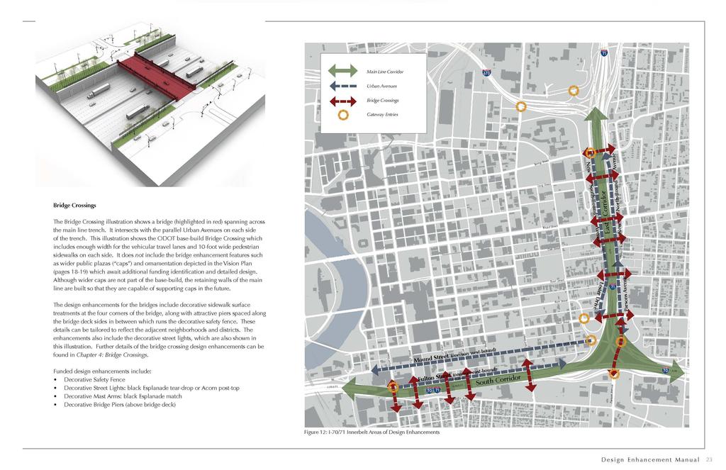
I-70/I-71 Project Public Meeting Presented By
|
|
|
- Myron Burns
- 5 years ago
- Views:
Transcription


1 I-70/I-71 Project Public Meeting Presented By Ohio Department of Transportation ms consultants, inc. engineers, architects, planners MSI Design June 9, 2010
2 W e l c o m e Thom Slack Planning Administrator, ODOT District 6

3 P r o j e c t P h a s i n g
4 P r o j e c t P h a s i n g Design-Build Contract Advertising for RFPs in late 2010 Phase 1 (North Interchange) Phase 1 - North Interchange Construction 2011
5 P r o j e c t P h a s i n g Final Design is underway Phase 1 (North Interchange) Phase 2 (East Interchange) Phase 1 - North Interchange Construction 2011 Phase 2 East Interchange Construction 2013
6 P r o j e c t P h a s i n g Final Design is Underway Phase 1 (North Interchange) Phase 3 (East Innerbelt) Phase 2 (East Interchange) Phase 1 - North Interchange Construction 2011 Phase 2 East Interchange Construction 2013 Phase 3 East Innerbelt Construction 2015

7 P u b l i c O u t r e a c h Complete Streets Initiative March - July 2010 Spring & Long Crossings June - July 2010 Main, Parsons, Grant & 18 th Crossings Starting July 2010 Broad, Oak, Town, Lester Crossings Starting August 2010
8 Standard Highway Bridge Long Street - today

9 Enhanced Bridge Project Starting Point Currently Proposed Design Features: Expanded Sidewalks Decorative Parapet Wall & Fence Upgraded Street Lights: black Esplanade tear-drop or Acorn post-top Upgraded Mast Arms: black Esplanade match Bridge Crossing Urban Urban Avenue Avenue

10 Standard Highway Bridge Pedestrian View Oak Street - today NORTH

11 Enhanced Bridge Pedestrian View NORTH
12 Bridge Crossing Enhancement Funding New Funding in 2010: ODOT, MORPC, and the City of Columbus now pledge $26 million for expanded bridge designs on East Corridor. Allows further improvement of bridges crossings. Includes Spring and Long Street Bridges in Phase 1.

13 Crossing Design Goals What we heard: Hide the Freeway Make the Bridge Crossings Inviting Use Complete Street Principles Reflect Neighborhood Character

14 Bridge Design Example Fort Washington Way Bridge Crossing NORTH

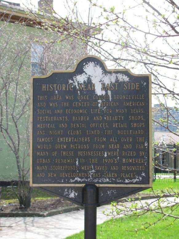
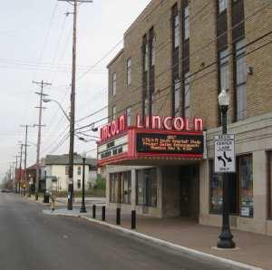
15 Spring & Long Street Area Today Columbus State King Art Complex CCAD Washington Ave Spring St. Long St. MLK Blvd. Blvd. Lincoln Theater Art Museum Jefferson Center Hamilton Park Broad St. NORTH

16 Spring & Long Street Area with Project Columbus State King Art Complex CCAD Washington Ave Spring St. Long St. MLK Blvd. Blvd. Lincoln Theater Art Museum Jefferson Center Hamilton Park Broad St. NORTH


17 Spring Street Existing Character


18 Long Street Existing Character
19 Gateway & Neighborhood Bridges

20 Spring & Long Street Bridge Area Existing and Urban Avenue Greenspace NORTH LESTER AVENUE LONG STREET SPRING STREET ELIJAH PIERCE AVENUE

21 Spring & Long Street Bridge Area Project Crossing Greenspace NORTH LESTER AVENUE LONG STREET SPRING STREET ELIJAH PIERCE AVENUE

22 Spring & Long Street Bridge Area New Bicycle Lanes & Circulation NORTH LESTER AVENUE LONG STREET SPRING STREET ELIJAH PIERCE AVENUE

23 Spring & Long Street Bridge Area Existing & Proposed Sidewalk Circulation NORTH LESTER AVENUE LONG STREET SPRING STREET ELIJAH PIERCE AVENUE

24 Spring & Long Street Bridge Area Complete Sidewalks & Bike Lane Circulation NORTH LESTER AVENUE LONG STREET SPRING STREET ELIJAH PIERCE AVENUE

25 Spring Street Bridge Today Looking West toward Downtown NORTH

26 Spring Street Bridge Concept Looking West toward Downtown NORTH

27 Spring Street Bridge Today Looking West on North Side of Bridge NORTH

28 Spring Street Bridge Concept Looking West on North Side of Bridge NORTH

29 Spring Street Bridge Today South Side Looking West NORTH

30 Spring Street Bridge Rendering South Side Looking West During the Day NORTH Elijah Elijah Pierce Pierce Avenue Avenue

31 Spring Street Bridge Rendering South Side Looking West at Night NORTH Elijah Elijah Pierce Pierce Avenue Avenue

32 Long Street Bridge Today Looking West toward Downtown NORTH

33 Long Street Bridge Concept Looking West toward Downtown NORTH

34 Long Street Bridge Today Aerial View NORTH

35 Long Street Bridge Concept Aerial View NORTH

36 Long Street Bridge Today Looking West on South Side of Bridge NORTH

37 Long Street Bridge Concept Looking West on South Side of Bridge NORTH

38 Long Street Bridge Today North Side View Looking West NORTH

39 Long Street Bridge Rendering North Side View Looking West During the Day Elijah Elijah Pierce Pierce Avenue Avenue NORTH

40 Long Street Bridge Rendering North Side View Looking West at Night NORTH Elijah Elijah Pierce Pierce Avenue Avenue

41 E a s t b o u n d I N I-71 I-670 Cleveland Ave. Mt. Vernon Ave. Long St. Columbus State Broad St.

42 E a s t b o u n d I N St. Clair Ave. I-670 Leonard Ave. I-71 Skyview Towers

43 E a s t b o u n d I Leonard Ave. N St. Clair Ave. I-670 Relocation of eastbound Leonard Avenue Relocation of bike/pedestrian path
44 W h y d o a N o i s e S t u d y? Required by Federal Regulations (23 CFR 772) Federally funded project Project adds lanes to existing highway Project changes the location or elevation of the highway 44
45 H o w w a s t h e N o i s e S t u d y D o n e? ODOT Standard Procedure FHWA Policy and Guidance Existing Noise Readings 45 Sites -- June 2009 Verify Computer Models Confirm Noise Sources
46 H o w w a s t h e N o i s e S t u d y D o n e? Computer Modeling (FHWA s TNM V2.5) Existing Sensitive Locations Outdoor Activity Areas Interiors of churches, hospitals, etc. New Highway Design Freeway Lanes Urban Avenues City Streets Bridges Year 2035 Predicted Traffic
47 N o i s e S t u d y R e s u l t s Existing Noise Levels currently exceed FHWA/ODOT Noise Abatement Criteria 67 db for residential areas (outdoor) Future Noise Levels will exceed FHWA/ODOT Noise Abatement Criteria Noise Impacts throughout project area
48 N o i s e S t u d y R e s u l t s Will this project increase current noise levels? About the same as the existing levels at most locations Already high enough to be an Impact and will continue to be an impact
49 N o i s e S t u d y R e s u l t s What mitigation did we consider? Impose vehicle and speed restrictions Move the alignment Create buffer zones Not appropriate for an urban interstate project
50 N o i s e S t u d y R e s u l t s Noise walls as mitigation Not effective in these locations East Corridor (I-71) South Corridor (I-70/71 overlap) Could be effective in these locations Near Shiloh Baptist Church not accepted East Split and I-70 east of 18 th Street pending public input
51 N o i s e S t u d y R e s u l t s Will the retaining walls reflect the noise? Just perceptible in South Corridor Not perceptible in East Corridor What about sound absorbing material on the retaining walls? Not effective at reducing perceptible noise

52 N e x t S t e p s Tonight - Open House Provide comments by June 25, 2010 Complete Environmental Documentation Follow-up for Spring & Long Details
53 O p e n H o u s e Spring & Long Crossings MORPC Shaping our Future Engineering & Traffic (I-670 Refinements) Complete Streets Noise Study Results

54 Hotline: Leslie Montgomery, P.E. Project Manager ODOT District E. William Street Delaware, OH Phone: Fax: Leslie.Montgomery@dot.state.oh.us
Macleod Trail Corridor Study. Welcome. Macleod Trail Corridor Study Open House. Presentation of Proposed Design Concepts
 Macleod Trail Corridor Study Welcome Macleod Trail Corridor Study Open House Presentation of Proposed Design Concepts Study Purpose Develop a corridor plan for Macleod Trail that aligns with The City s:
Welcome to the Cross County Trail Public Input Session!
 Welcome to the Cross County Trail Public Input Session! Please sign in on the table below! What are we doing here? Camden County has proposed a bicycle and pedestrian trail spanning across the entire county.
NFTA Access Enhancement Study for Canalside and Cobblestone Alternatives Discussion. Alternative A South Park Avenue
 Alternative A South Park Avenue Alternative A Summary Alternative A extends Metro Rail service around the foot of Main Street east along South Park Avenue to serve a new station platform located along
Expo E-News. Santa Monica s Getting Ready for Expo! Phase 2 Update Page 2. Keeping Our Community Informed
 Expo E-News Keeping Our Community Informed Winter 2014 Santa Monica s Getting Ready for Expo! Phase 2 Update Page 2 In this Issue : Page 4: Construction Update Page 6: Artist Profiles For more information
BONITA BEACH ROAD. May 18, Ian Lockwood, PE Cindy Zerger, AICP, ASLA Ken Ray, RLA. Greg Diserio, RLA. Tara Salmieri, AICP
 BONITA BEACH ROAD May 18, 2016 Ian Lockwood, PE Cindy Zerger, AICP, ASLA Ken Ray, RLA Greg Diserio, RLA Tara Salmieri, AICP Toole Design Group Engineers Planners Landscape Architects Authors BONITA BEACH
Crystal City Station Improvements. Project Overview. Table 2: North Entrance. Table 1: South Entrance. 20th St. S 18th St. S.
 Table 1: South Entrance Table 2: North Entrance 20th St. S 18th St. S Proposed Second Entrance Crystal Drive Existing Station Location Platform Future 4 th Track Future New Airport Connection (by others)
Construction underway. STATUS: 229 5,190 5,419 5,305 STIP REFERENCE #FR /01/2013
 FREDERICK COUNTY STATE HIGHWAY ADMINISTRATION -- Frederick County -- Line 1 PROJECT: I-7, Baltimore National Pike INTERSTATE CONSTRUCTION PROGRAM DESCRIPTION: Widen I-7 east of MD 355 to east of MD 144
Innerbelt Bridge Contract Group 2 Tremont / Towpath Trail and Gateway January 8, 2013
 Innerbelt Bridge Contract Group 2 Tremont / Towpath Trail and Gateway January 8, 2013 Cleveland Innerbelt Construction Schedule former schedule 2011 Winter Begin Construction Innerbelt CCG1 (WB Bridge)
LANCASTER CORRIDOR REDEVELOPMENT ROSEDALE STREET REDESIGN PEACH STREET RAILROAD CROSSINGS
 LANCASTER CORRIDOR REDEVELOPMENT ROSEDALE STREET REDESIGN PEACH STREET RAILROAD CROSSINGS Presented at the SEE Development Excellence Workshop By Councilmember Wendy Davis, City of Fort Worth March 24,
ONONDAGA CREEKWALK PHASE II. Public Information Meeting Series 1
 ONONDAGA CREEKWALK PHASE II Public Information Meeting Series 1 Andrew Maxwell Director, Syracuse-Onondaga County Planning Agency Owen Kerney Assistant Director for City Planning Russell Houck, PE City
COTA Implements Service Changes for January 2010
 NEWS RELEASE Tuesday, Dec. 22, 2009 COTA CONTACT Beth Berkemer Public Relations and Media Relations Manager 614-275-5938 Phone 614-275-5933 Fax COTA Implements Service Changes for January 2010 COLUMBUS
Trails, steps, & P-Patch to be south of I- 5 Colonnade
 UW Campus Trails, steps, & P-Patch to be south of I- 5 Colonnade Blaine and Howe Street steps REI N new lighting existing features connector trail new features or improvements overhead freeway and support
DULLES AREA HIGHLIGHTS. Gary Garczynski Commonwealth Transportation Board Northern Virginia District. Committee for Dulles August 4, 2016
 DULLES AREA HIGHLIGHTS Gary Garczynski Commonwealth Transportation Board Northern Virginia District Committee for Dulles August 4, 2016 Smart Scale (formerly HB2) Overview Round 1 completed with the adoption
CONSTRUCTION PROJECTS IN CUYAHOGA COUNTY CLEVELAND EUCLID 3/9/18 RICHMOND MAYFIELD HIGHLAND HEIGHTS HEIGHTS SOUTH EAST MAYFIELD EUCLID CLEVELAND
 BAY VILLAGE WESTLAKE OLMSTED NORTH TOWNSHIP OLMSTED FALLS OLMSTED BEREA STRONGSVILLE ROYALTON NORTH BROOK PARK PARMA PARMA BROADVIEW BRECKSVILLE HILLS SEVEN INDEPENDENCE BROOKLYN RIVER ROCKY LAKEWOOD PARK
Section 106 Update Memo #1 Attachment D. Traffic Diversion & APE Expansion Methodology & Maps
 Section 106 Update Memo #1 Attachment D Traffic Diversion & APE Expansion Methodology & Maps I-65/I-70 North Split Interchange Reconstruction Project (Des. Nos. 1592385 & 1600808) Traffic Diversion and
Alliant Energy Center Visioning Workshop Input Madison, WI July 20, 2017
 Alliant Energy Center Visioning Workshop Input Madison, WI July 2, 217 A neighborhood meeting was held on July 18 and 19 th, 217 to gather community feedback on the topics of connections, destination district,
Introduction. Project Overview
 Washington Blvd./Andora Widening Project Community Open House & Public Scoping Meeting Summary Wednesday, September 21, 2016 6:00 7:30 p.m. Vencil Brown Elementary School, Roseville Introduction On Wednesday,
District Construction Progr am. John R. Kasich, Ohio Governor Jerry Wray, ODOT Director Steve Mary, P.E., District Deputy Director
 District 8 2014 Construction Progr am Preble Greene Butler Warren Clinton Lebanon Hamilton Clermont Serving Butler, Clermont, Clinton, Greene, Hamilton, Preble and Warren Counties. John R. Kasich, Ohio
Stage 2 ION: Light Rail Transit (LRT) from Kitchener to Cambridge
 from Kitchener to Cambridge") Stage 2 ION: Light Rail Transit (LRT) from Kitchener to Cambridge Public Consultation Centre (PCC) No. 3 Please Sign-in Cambridge City Hall November 21, 2017 2:00 to 8:00pm Preston Memorial Auditorium
Stage 2 ION: Light Rail Transit (LRT) from Kitchener to Cambridge Public Consultation Centre (PCC) No. 3 Please Sign-in Cambridge City Hall November 21, 2017 2:00 to 8:00pm Preston Memorial Auditorium
SR 934 Project Development And Environment (PD&E) Study
 Study") SR 934 Project Development And Environment (PD&E) Study Project Advisory Group Meeting March 1, 2018 State Road 934/NE/NW 79th Street from west of I-95 (NW 13th CT) to N. Bayshore Drive PD&E STUDY SR 934/NE/NW
SR 934 Project Development And Environment (PD&E) Study Project Advisory Group Meeting March 1, 2018 State Road 934/NE/NW 79th Street from west of I-95 (NW 13th CT) to N. Bayshore Drive PD&E STUDY SR 934/NE/NW
Ossington Station Easier Access Project - Construction & Public Art Concept Update
 Ossington Station Easier Access Project Construction & Public Art Concept Update Open House College/Shaw Library 1 Easier Access Program Wide Committed to making all stations accessible by 2025 34 stations
East Palomar Street Transit Station and Park & Ride Public Meeting Thursday, June 23, :00 to 8:00 p.m.
 East Palomar Street Transit Station and Park & Ride Public Meeting Thursday, June 23, 2011 6:00 to 8:00 p.m. 1 2050 Draft RTP San Diego s Regional Transportation Plan (RTP) $196 billion infrastructure
I-75 in Hamilton County Project Termini
 I-75 in Hamilton County Project Termini Introduction As part of the North South Transportation Initiative (NSTI), capacity improvements were recommended for the I-75 corridor through Hamilton County from
SR 429/WEKIVA PARKWAY FTBA CONFERENCE March 20-21, Presented By Suzanne Phillips, P.E., FDOT District 5
 SR 429/WEKIVA PARKWAY FTBA CONFERENCE March 20-21, 2012 Presented By Suzanne Phillips, P.E., FDOT District 5 Project Description The Wekiva Parkway project constructs 25 centerline miles of new toll expressway.
Northern Virginia District State of the District. Helen L. Cuervo, P.E. District Engineer October 18, 2017
 Northern Virginia District State of the District Helen L. Cuervo, P.E. District Engineer October 18, 2017 Susan Shaw, P.E., Megaprojects Director Virginia Department of Transportation American Society
Citrus Heights Creek Corridor Trail Project Trail Advisory Group Field Trip #2 September 11, :00 11:00 am Trellis Hall, Citrus Heights
 September 11, 2013 9:00 11:00 am Trellis Hall, Citrus Heights Project Overview The City of Citrus Heights is studying the feasibility of establishing a multi use trail system within the City s 26 miles
Update on Route 1 Efforts
 County of Fairfax, Virginia Update on Route 1 Efforts Transportation Advisory Committee October 20, 2015 Leonard Wolfenstein, FCDOT Jane Rosenbaum, FCDOT Doug Miller, FCDOT Route 1 Corridor 16- mile section
#1. Why is the City doing this project?
 Community Workshop #2 January 2016 #1. Why is the City doing this project? Broadway and Lincoln are in constant change Broadway and Lincoln are in constant change Broadway and Lincoln are in constant change
2017 TBARTA Future Regional Priority Projects Adopted by TBARTA Board, December 9, 2016
 2017 TBARTA Future Regional Priority Projects Adopted by TBARTA Board, December 9, 2016 Project numbers do not signify ranking they are for mapping identification purposes only. 1. 15th Street East The
AVAILABLE FOR SALE ENTITLED 53,228 SF BUILDING FOR SALE Washington Dr., Fontana. Property Features:
 Property Features: Free - Standing; Entitled 53,8 SF;,311 SF Office (3) Dock High Loading Rare, New Planned Wholesale Warehouse Corner Location (Live Oak Ave. & Washington Dr.) 1 Block South Of Valley
Longmont to Boulder Regional Trail Jay Road Connection DRAFT FINAL REPORT
 Longmont to Boulder Regional Trail Jay Road Connection DRAFT FINAL REPORT December 2018 Project Summary Boulder County, Colorado, in partnership with the City of Boulder, is evaluating options for multi-use
Noise Abatement Decision Report
 Mid County Parkway NADR Noise Abatement Decision Report Noise Study Report, January 212 Riverside County, California 8-RIV-MCP PM./16.3; 8-RIV-2 PM 28./34.3 EA 8-F32 (PN 8125) April 212 This page intentionally
TBARTA: 2015 Master Plan and Tampa Bay Express Project
 TBARTA: 2015 Master Plan and Tampa Bay Express Project The Real Story Who: Tampa Bay Area Regional Transportation Authority What: Develop and implement a Regional Transportation Master Plan for the seven-county
user s guide to Transportation Improvements in Astoria Planning Efforts outside Astoria for more information, contact:
 The Miles Crossing/ Jeffers Garden transportation plan (underway), will identify needed improvements to the Warrenton Astoria Highway and local street improvements to serve expected growth in the Miles
Public Open House. Chief Peguis Trail Project
 Public Open House Chief Peguis Trail Project CHIEF PEGUIS TRAIL OPEN HOUSE Welcome! Please browse the display boards Project Engineers and City of Winnipeg representatives are available to address your
Dufferin Jog Elimination Project
 Project Project Status Update November 14 2007 Project History Planning Alternatives Criteria Measured Project Benefits Structural Configurations Considered Structural Design Considerations The Preferred
ORANGE COUNTY TRANSPORTATION AUTHORITY. Go Local Fixed-Guideway Program History and Project Update. PowerPoint 3
 ORANGE COUNTY TRANSPORTATION AUTHORITY Go Local Fixed-Guideway Program History and Project Update PowerPoint 3 Santa Ana-Garden Grove Fixed Guideway Project OCTA Board of Directors September 26, 2011 Project
Strategic Signal Timing Changes = BIG Results. Barbara Jones, PE, PTOE DGL Consulting Engineers, LLC Senior Traffic Engineer
 Strategic Signal Timing Changes = BIG Results Barbara Jones, PE, PTOE DGL Consulting Engineers, LLC Senior Traffic Engineer Pre Signal Timing Updates Signal Timing Updates Average Retiming Interval Percent
I-579 Urban Open Space CAP Project. Final Land Development Plan (FLDP) Pittsburgh Department of City Planning
 Pittsburgh Department of City Planning") Final Land Development Plan (FLDP) I-579 Urban Open Space CAP Project Sports & Exhibition Authority (SEA) of the City of Pittsburgh and Allegheny County Project bounded by Chatham St. / Centre Ave. / Washington
Final Land Development Plan (FLDP) I-579 Urban Open Space CAP Project Sports & Exhibition Authority (SEA) of the City of Pittsburgh and Allegheny County Project bounded by Chatham St. / Centre Ave. / Washington
Route 29 Solutions Projects
 Your guide to the Route 29 Solutions Projects For full details & continued engagement please visit www.route29solutions.org The Route 29 Solutions Package is a $230 million investment into the improvement
Welcome! This open house provides an early look at: Garage layout and access Potential pedestrian, bicycle and transit improvements
 Welcome! Sound Transit is improving access to Station for drivers, pedestrians, bicyclists and bus riders, including construction of a new garage. This open house provides an early look at: Garage layout
Update: Manhattan Community Board 1 Land Use, Economic Development & Zoning committee February 12, 2018
 Update: Manhattan Community Board 1 Land Use, Economic Development & Zoning committee February 12, 2018 1 GOVERNORS ISLAND IS FOR NEW YORKERS 2 WE RE MOVING TOWARDS A YEAR-ROUND, 24 HOUR COMMUNITY 3 Governors
Gulf Coast MPO Obligated Projects
 Gulf Projects */ 104866/801000 STPD-9370-00(004) Dedeaux Rd. From Three Rivers Rd. to SR 605. MS $3,259,353 106448/701000 STP-8971-00(005) City of City of - widen to include three lanes on Hospital Road
CLAREMONT CLUB, SPA & RESIDENCES
 LANDMARKS SUBMITTAL LOCATION MAP PROJECT DIRECTORY SHEET INDEX VICINITY MAP Ashby Ave PROJECT SITE Tunnel Rd PROJECT SITE Claremont Ave OWNER Claremont Hotel Properties, LP 41 Tunnel Road Oakland, CA 94705
Town of Markham Yonge and Steeles Corridor Study and City of Vaughan Yonge Street Area Study
 STAFF REPORT ACTION REQUIRED Town of Markham Yonge and Steeles Corridor Study and City of Vaughan Yonge Street Area Study Date: August 14, 2009 To: From: Wards: Reference Number: North York Community Council
CHAPTER FOUR RECOMMENDED NOISE COMPATIBILITY PROGRAM MEASURES
 CHAPTER FOUR RECOMMENDED NOISE COMPATIBILITY PROGRAM MEASURES This chapter provides the detailed descriptions of the recommended Part 150 noise abatement, land use management, and program management measures
Madison Metro Transit System
 Madison Metro Transit System 1101 East Washington Avenue Madison, Wisconsin, 53703 Administrative Office: 608 266 4904 Fax: 608 267 8778 TO: FROM: SUBJECT: Plan Commission Timothy Sobota, Transit Planner,
Public Informational Meeting
 Public Informational Meeting April 17, 2007 Bow-Concord I-93 I Transportation Planning Study Bow-Concord Interstate 93 Transportation Planning Study Context Sensitive Solutions Planning Steps Screen Alternatives
25 th Avenue Grade Separation. September 13, 2017
 25 th Avenue Grade Separation September 13, 2017 Agenda I. Overview II. III. IV. Project Description Project Benefits Project Construction V. Next Steps VI. Questions 2 Overview Project Location 4 E. 25
State Route 8 Corridor. Northern Summit County s Path to Success
 State Route 8 Corridor Northern Summit County s Path to Success Construction Guide: 2008-2009 State Route 8 corridor work description State Route 8 Corridor 10 projects $262 million With its close proximity
MPRB: Southwest LRT Community Advisory Committee Issues and Outcomes by Location Current to: 12 November 2010
 MPRB: Southwest LRT Community Advisory Committee Issues and Outcomes by Location Current to: 12 November 2010 This is a compilation of issues and outcomes identified by the CAC. It is a work in progress,
1.2 Corridor History and Current Characteristics
 SECTION 1 Description and Background of Study Area 1.1 Introduction This preliminary engineering report was prepared for the Alaska Department of Transportation and Public Facilities (ADOT&PF). It is part
Vasona Light Rail Signal Design Challenges. Hugh D. MacGillivray, Hatch Mott MacDonald Dennis Mellon, Santa Clara County Transportation Authority
 Vasona Light Rail Signal Design Challenges Hugh D. MacGillivray, Hatch Mott MacDonald Dennis Mellon, Santa Clara County Transportation Authority Abstract The Vasona line is the most recent extension of
Overview of Boston Logan Operations and Noise from Overflights. Presentation to Massport Board March 19, 2015
 Overview of Boston Logan Operations and Noise from Overflights Presentation to Massport Board March 19, 2015 Contents How the Airport Operates Massport s Noise Abatement Program for Logan Recent Trends
25 th Avenue Grade Separation. December 13, 2017
 25 th Avenue Grade Separation December 13, 2017 Agenda I. Overview II. III. IV. Project Description Project Benefits Project Construction V. Next Steps VI. Questions 2 Overview Project Location 4 E. 25
TRAFFIC COMMISSION, VILLAGE OF LINCOLNWOOD 6900 N. Lincoln Avenue, Lincolnwood, IL 60712
 TRAFFIC COMMISSION, VILLAGE OF LINCOLNWOOD 6900 N. Lincoln Avenue, Lincolnwood, IL 60712 Meeting Agenda Thursday, May 25, 2017 7:00 p.m. Village Hall Council Chambers 6900 N. Lincoln Ave. Lincolnwood,
Transportation Supporting Dulles Airport
 Transportation Supporting Dulles Airport Committee for Dulles Economic Development and Transportation Committee July 12, 2018 Tom Biesiadny, Director Fairfax County Multiple Transportation Improvements
Analysis and Feasibility Broward County Convention Center Master Plan Study Fort Lauderdale, FL HKS I Urban Design Studio
 Analysis and Feasibility Broward County Convention Center Master Plan Study Fort Lauderdale, FL 04.01.14 HKS I Urban Design Studio Summary of Outreach Purpose of Stakeholder Outreach Identify and engage
More than just express lanes
 A N E W C H O I C E F O R A B E T T E R C O M M U T E Tampa Bay Regional Planning Council August 8, 2016 Florida Department of Transportation, District Seven More than just express lanes ALT 19 41 581
Gold Coast. Rapid Transit. Chapter twelve Social impact. Chapter content
 Gold Coast Rapid Transit Chapter twelve Social impact Chapter content Social impact assessment process...235 Existing community profile...237 Consultation...238 Social impacts and mitigation strategies...239
Fairfax County Parkway Widening Fairfax County
 Get Involved VDOT representatives will review and evaluate information received as a result of this meeting. Please fill out the comment sheet provided in this brochure if you have any comments or questions.
Downtown Mobility Hub: Draft New Precinct Plan. Art Gallery of Burlington September 7, 2017
 Downtown Mobility Hub: Draft New Precinct Plan Art Gallery of Burlington September 7, 2017 Meeting Purpose To present the draft new precinct plan for the Downtown Mobility Hub To get community input on
PURPOSE AND NEED (CONCURRENCE POINT 1) NEW CANADA ROAD PROJECT FROM STATE ROUTE 1 (U.S. HIGHWAY 70) TO U.S. INTERSTATE 40
 NEW CANADA ROAD PROJECT FROM STATE ROUTE 1 (U.S. HIGHWAY 70) TO U.S. INTERSTATE 40") PURPOSE AND NEED (CONCURRENCE POINT 1) NEW CANADA ROAD PROJECT FROM STATE ROUTE 1 (U.S. HIGHWAY 70) TO U.S. INTERSTATE 40 Project Description The primary purpose of this project is to improve the major
PURPOSE AND NEED (CONCURRENCE POINT 1) NEW CANADA ROAD PROJECT FROM STATE ROUTE 1 (U.S. HIGHWAY 70) TO U.S. INTERSTATE 40 Project Description The primary purpose of this project is to improve the major
DIRECTOR S REPORT TRANSPORTATION BOARD AUGUST 14, 2017
 DIRECTOR S REPORT TRANSPORTATION BOARD AUGUST 14, 2017 1 EMERGENCY OPERATIONS NDOT ISSUED A $360,000 EMERGENCY CONTRACT FOR REPAIR OF FLOOD DAMAGE ON SR 375 LINCOLN COUNTY 3 FT. SINK HOLE TO BE REPAIRED
2016 Regional Transportation Alternatives Program (TAP) Grant Application
 Grant Application") 2016 Regional Transportation Alternatives Program (TAP) Grant Application PROJECT TITLE: Yelm-Tenino Trail Extension Feasibility Study TRPC use only GENERAL PROJECT INFORMATION Agency or Organization City
2016 Regional Transportation Alternatives Program (TAP) Grant Application PROJECT TITLE: Yelm-Tenino Trail Extension Feasibility Study TRPC use only GENERAL PROJECT INFORMATION Agency or Organization City
SOUTHEAST BOULEVARD Planning Study Washington, DC. Progress Drawings October 6, 2014
 Existing Conditions Site Plan CONGRESSIONAL CEMETERY SOUTHEAST BOULEVARD Planning Study Concept A (formerly A-1) Site Plan Concept A (formerly A-1) Concept A proposes an expansion of the Capitol Hill neighborhood
Abbott Rd Rehabilitation Phase II - Elmore Rd to Birch Rd
 Abbott Rd Rehabilitation Phase II - Elmore Rd to Birch Rd Project ID SOA07003 Department State of Alaska Project Type Improvement Start Date December 2017 Location Assembly: Section 4, Seats F & G, Assembly:
US 19 Sunset Point Rd to Countryside Blvd.
 Frontage Lanes Alternative Six-Lane Roadway Two-Lane, One-Way Frontage Lanes Close All Median Openings w/ Concrete Median Barrier Construct Within Existing Right-of-Way Status Update Construction started
TRAIL ANNUAL REPORT
 TRAIL ANNUAL REPORT 2016-17 Identify Undeveloped projects identified in the City s Greenprint or trail database 15.90 miles Study Projects that have been or are currently being studied to determine a feasible
DOWNTOWN BRT ALTERNATIVE - 19th AVE
 DOWNTOWN BRT ALTERNATIVE - 9th AVE New Route and Increased Service in Mixed Traffic Existing Route and Service in Mixed Traffic Light Rail Line / New Route and Increased in Exclusive Guideway Existing
DEMOGRAPHICS AND EXISTING SERVICE
 EXECUTIVE SUMMARY The Central Corridor light-rail transit (LRT) project will open in 2014 and operate between downtown Minneapolis and downtown St. Paul, serving the University of Minnesota and University
S i t e A n a ly s i s
 S i t e A n a ly s i s 11 SECTION B SITE ANALYSIS Existing Conditions TRANSPORTATION CONTEXT: The Ohlone Greenway site, paralleling San Pablo Avenue to the west, is centrally located within the City of
Engagement Summary Report. Trans-Canada Highway 1 RW Bruhn Bridge Replacement Project. Community Engagement November 15, 2016 to January 15, 2017
 Trans-Canada Highway 1 RW Bruhn Bridge Replacement Project Community Engagement November 15, 2016 to January 15, 2017 Engagement Summary Report February 2017 Prepared by Kirk & Co. Consulting Ltd. Trans-Canada
Downtown to Defiance Trolley Key Messages Jan. 2017
 Downtown to Defiance Trolley Key Messages Jan. 2017 Overarching Messages This is a demonstration (pilot) project for one summer. We will evaluate how it went to see if we can offer it again in the future.
Airport Planning Area
 PLANNING AREA POLICIES l AIRPORT Airport Planning Area LOCATION AND CONTEXT The Airport Planning Area ( Airport area ) is a key part of Boise s economy and transportation network; it features a multi-purpose
U.S. 33 Ravenswood Connector
 U.S. 33 Ravenswood Connector Project History When I-77 was planned to pass less than five miles east of Ravenswood, West Virginia in Jackson County, officials began taking steps to acquire an Ohio River
Mohawk Hudson Bike Hike Trail Crossroad Connection Study
 Summary Report - April 21, 2003 Mohawk Hudson Bike Hike Trail Crossroad Connection Study Summary Report Introduction The Capital District Transportation Committee (CDTC), in partnership with Albany County,
TRANSPORTATION ELEMENT
 Transportation TRANSPORTATION ELEMENT Data, Inventory, and Analysis Prepared by Contents 1.0 INTRODUCTION... 1 2.0 EXISTING CONDITIONS... 1 2.1 Roadways... 1 2.1.1 Jurisdiction... 1 2.1.2 Functional Classification...
Gardner: overview. Santa Fe, Oregon, and California National Historic Trails UNINCORPORATED JOHNSON COUNTY OLATHE UNINCORPORATED JOHNSON COUNTY
 Santa Fe, Oregon, and California ational Historic Trails : overview 99: p.134 100: p.135 GARDER JUCTIO 102: p.137 56: p.126 EDGERTO Burlington orthern Intermodal and Logistics 98: p.133 101: p.136 S Waverly
Independence: overview
 : overview Kentucky Ave 8: p.30 SUGAR CREEK SATA FE. OREGO, CALIFORIA 7: p.29 6: p.28 9: p.31 10: p.32 Square, Jackson County Courthouse. Photo: Vireo Trail swale area, Santa Fe Trail. Photo: Vireo HISTORIC
The Ohio State University Airport Master Plan Update Public Meeting 2
 The Ohio State University Airport Master Plan Update Public Meeting 2 Date: Tuesday, March 12, 2019 Time: 6:00-8:00 p.m. Location: Ohio State Airport, 2160 West Case Road, Columbus, OH 43235 Meeting Summary
CHAPTER 6 NOISE EXPOSURE
 CHAPTER 6 NOISE EXPOSURE FAA requires that the NEM submitted for review represent the aircraft noise exposure for the year of submittal (in this case 2008) and for a future year (2013 for OSUA). However,
October 18, Terry Hartwick Director, North Little Rock Parks and Recreation 2700 Willow Street North Little Rock, AR 72114
 October 18, 017 Terry Hartwick Director, North Little Rock Parks and Recreation 700 Willow Street North Little Rock, AR 7114 Dear Mr. Hartwick: Re: ARDOT Job Number CA060 30 Crossing Pulaski County The
Item # 28. Chief Capital Management Officer Report. November 20, 2008
 Item # 28 Chief Capital Management Officer Report November 20, 2008 1 Metro Gold Line Eastside Extension Project Update November 2008 6 Mile Alignment 1.7 Miles of Tunnel 8 Stations (6 At-grade & 2 Underground)
CITY OF COACHELLA CAPITAL IMPROVEMENT PROGRAM TOTAL PROJECTS REVENUE SUMMARY TABLE ES-1
 Funding Prior Years Expenditures to 6-30-10 Total Project Cost Estimated Expenditures for FY 2006 Non- Taxable Non- Housing RDA Bonds Bond Proceeds 2005 Prop. 1B USDA Loans/ Grants Dev Impact Fees TUMF
For Lease Retail Space LUXURY
 1127 LUXURY Euclid Avenue,Cleveland, Ohio 44115 RYAN FISHER Vice President Retail Services DIRECT 216 239 5069 ryan.fisher@colliers.com > PROPERTY HIGHLIGHTS Excellent opportunity to locate at the center
Engagement Summary Report. Trans-Canada Highway 1 RW Bruhn Bridge and Approaches Project Community Engagement February 1 18, 2018.
 Trans-Canada Highway 1 RW Bruhn Bridge and Approaches Project Community Engagement February 1 18, 2018 Engagement Summary Report April 2018 Prepared by Kirk & Co. Consulting Ltd. Trans-Canada Highway 1
Update on Trinity Trails. Presented by: Richard Zavala, Director Park and Recreation Department February 7, 2017
 Update on Trinity Trails Presented by: Richard Zavala, Director Park and Recreation Department February 7, 2017 Overview Provide review of trail planning and development along the main stem Trinity River
Pattullo Bridge Replacement Project
 JULY 2018 PROJECT OVERVIEW Pattullo Bridge Replacement Project engage.gov.bc.ca/pattullobridge Artist s rendering of the proposed new Pattullo Bridge Pattullo Bridge Replacement Project 1 Priority Need
Area Surrounding Maplewood Manor
 BAY CITY, MICHIGAN HOUSING COMMISSION Neighborhood Revitalization Plan Area Surrounding Maplewood Manor January 13, 2014 CITY COMMISSION DRAFT PLAN PRESENTATION BAY CITY, MICHIGAN 1 Planners Phil McKenna,
RECENT SCENARIO PLANNING FOR THE REGIONAL FREEWAY AND HIGHWAY PROGRAM MARICOPA ASSOCIATION OF GOVERNMENTS
 RECENT SCENARIO PLANNING FOR THE REGIONAL FREEWAY AND HIGHWAY PROGRAM MARICOPA ASSOCIATION OF GOVERNMENTS National Scenario Planning Peer Exchange July 10, 2012 2012, All Rights Reserved. 1 MAG Transportation
RUSHMORE CONNECTOR TRAIL PROPOSAL
 PURPOSE AND NEED Background The U.S. Forest Service, Black Hills National Forest (Forest Service) has received a special use permit application from the State of South Dakota Department of Game, Fish and
Lafourche Parish Government REQUEST FOR QUALIFICATIONS. Landscape Architectural Services
 Lafourche Parish Government REQUEST FOR QUALIFICATIONS Landscape Architectural Services Bayou Lafourche Parish Multi-Use Path Feasibility Study Phase 1 And Bayou Lafourche Parish Multi-Use Path Feasibility
Building the transportation network we need for the future in Niagara Region
 Building the transportation network we need for the future in Niagara Region Niagara@metrolinx.com Metrolinx.com/Niagara Metrolinxengage.com INSERT FOOTER 1 WHO IS METROLINX? Metrolinx was created in 2006
msp macnoise.com MSP Noise Oversight Committee (NOC) November 17, 2010
 November 17, 2010") MSP Noise Oversight Committee (NOC) November 17, 2010 Operations Update Technical Advisor s Report Summary MSP Complaints September October 2010 3,025 3,567 2009 6,350 6,001 Total Operations September
MSP Noise Oversight Committee (NOC) November 17, 2010 Operations Update Technical Advisor s Report Summary MSP Complaints September October 2010 3,025 3,567 2009 6,350 6,001 Total Operations September
Ohio Department of Transportation Traffic Advisory. District 4 Allen C. Biehl, P.E., Deputy Director S. Arlington Road.
 Ohio Department of Transportation Traffic Advisory District 4 Allen C. Biehl, P.E., Deputy Director 2088 S. Arlington Road. Akron, Ohio 44306 www.transportation.ohio.gov/dist4 Friday, September 18, 2015
Key Center. Enjoy a close proximity to Downtown Bellevue s lively entertainment and shopping center, surrounded by a wide variety of dining options.
 Key Center The attractive design of Key Center, coupled with vibrant onsite and nearby amenities, creates endless opportunities for exploration and collaboration Enjoy a close proximity to Downtown Bellevue
STITCH TRANSFORMATIVE IDEA 3. SHORELINE STITCH. Re-connect the city to the waterfront and link the east and west Core Circle landscapes
 SHORE STITCH TRANSFORMATIVE IDEA 3. SHORELINE STITCH Re-connect the city to the waterfront and link the east and west Core Circle landscapes 126 LINE PUBLIC WORK 127 TRANSFORMATIVE IDEA 3. SHORELINE STITCH
First rail. August 2011
 August 2011 First rail A downtown resident showed his son in early August the first completed section of embedded track on Fourth Street in front of the Farmer s Market. During July, the Central Corridor
2 Construction Program
 2018 C P 2018 Districtonstruction 2 Construction Program rogram district 2 Governor John Kasich ODOT Director Jerry Wray District Deputy Director Pat McColley, PE, SI 2018 Construction Program Thank you