Osceola County Comprehensive Plan. Capital Improvements Element Data & Analysis
|
|
|
- Felicia Collins
- 6 years ago
- Views:
Transcription
1 Osceola County Comprehensive Plan Capital Improvements Element Data & Analysis
2
3
4
5
6
7
8
9

10
11
12
13
14
15
16
17
18
19
20
21
22
23
24
25
26
27
28
29
30
31
32
33
34
35
36
37

38
39
40
41
42
43

44
45 APPENDIX Osceola County Comprehensive Plan Capital Improvements Element Annual Update Data and Analysis Supports the Goals, Objectives and Policies adopted on June 22, 29
46 TABLE OF CONTENTS Introduction 3 Changes to Attachment Fiver-Year Schedule of Capital Improvements as found in the Goals, Objectives and Policies of the Capital Improvements Element of the Osceola County Comprehensive Plan. 6 Changes to the Financial Tables of the Capital Improvements Element 2 Roadway Segment Analysis Fiscal Year 28/29 through Fiscal Year 22/23 48 Table -23 Projected Roadway Capacity Analysis Map Roadway Segments Projected to Operate Below Adopted Level of Service in Year 23
47 INTRODUCTION This document is the first annual update to the Capital Improvements Element of the Osceola County Comprehensive Plan as adopted by the Board of County Commissioners in December, 27. Osceola County is required to update the adopted Capital Improvements Element (CIE) of the Osceola County Comprehensive Plan, including Attachment, Five Year Schedule of Improvements, every year (Section (3) (b) a., Florida Statutes, and Rule 9J-5.6(5), Florida Administrative Code). The purpose of the CIE and the Five-Year Schedule of Improvements is to identify capital improvements needed to implement the Comprehensive Plan and to ensure adopted level of service (LOS) standards are achieved and maintained for concurrency related facilities. If the LOS standards are not met, concurrency management requires a local government to deny applications for development orders and permits until the deficiency is addressed. To assure that facilities will be in place to maintain LOS standards in a timely manner and prevent a concurrency moratorium, the Five-Year Schedule of Improvements must address deficiencies and be financially feasible. In 25, several changes regarding the Capital Improvements Element have been made to the State s Growth Management Laws. Listed below are some of the significant changes to the CIE requirements: The annual CIE update is adopted under an expedited process with a single public hearing and compliance review by the State Department of Community Affairs (DCA) (Section (3)(b)2., F.S.); Planned revenue sources can only be utilized in the last two years of the Five-Year (Schedule of Improvements Section (32), F.S); The Schedule of Improvements must include the Metropolitan Planning Organization s (MPO) Transportation Improvement Plan (TIP) if the improvements in the TIP are used to ensure concurrency and financial feasibility (Section (3)(a)6., F.S.); A plan amendment is required to change the scheduled project construction date (Section (3) (b)., F.S.); If a planned revenue source is used, the plan must include existing revenue sources that will be used if the referendum or other action does not secure the planned funding source (Section (3) (a) 5., F.S.); The Schedule of Improvements must reflect proportionate fair-share transportation projects ; 3
48 The Schedule must incorporate water supply projects 8 months after the water management districts update their regional water supply plans; and The CIE must include school projects consistent with the school district s work plan, a public school facilities LOS standard, school concurrency areas, and proportionate fairshare school projects. To comply with the requirements of Chapter 63, F.S., Osceola County has prepared proposed changes to its adopted CIE. The following items make up this document. Changes to the Goals, Objectives and Policies (GOPs) of the Capital Improvements Element (CIE) as adopted by the Board of County Commissioners on December 2, 27. Those changes include the updating of Attachment Five-Year Schedule of Capital Improvements as referenced in Policy.2.. of the CIE GOPs. When the Comprehensive Plan Update was approved in December, 27, the County incorporated the entire adopted FY27/28 Capital Improvements Plan (CIP), as adopted on September 25, 27, into the Comprehensive Plan as its Five-Year Schedule of Improvements. The CIP, as it is referenced in the adopted Comprehensive Plan, includes all projects adopted in the CIP; projects necessary to implementing the Comprehensive Plan were identified in the CIP in italics. The proposed CIE amendments updates Attachment to include, as required by Chapter 63 F.S. and Rule 9J-5, F.A.C., those projects identified as necessary to implementing the Osceola County Comprehensive Plan. The proposed update begins in FY28/29 and rolls in FY 22/23. Attachment also includes the Toho Water Authorities Capital Improvements Program, the FY28/29 City of St. Cloud s Capital Improvements Program for Water, Sewer and Non-Potable Water, and the portion of the 28 Metroplan Orlando Transportation Improvement Plan pertaining to Osceola County. The adopted FY28/29 Osceola County CIP is submitted with the amendments as Attachment 2. The Osceola County School District 28/29 5-Year District Facilities Work Plan and School District of Osceola County Five Year Capital Outlay Plan School Year 28-29, as referenced in Policy.4.. of the CIE GOPs, appear as Attachment 3; Changes to the Financial Tables in the Capital Improvement Element. The financial tables, as required by Rule 9J-5.6)(2)(f), F.A.C., are updated from the 25 CIE data and analysis section and are utilized to assess the County s ability to finance the capital improvements required to implement the Comprehensive Plan. To implement the Comprehensive Plan, Osceola County anticipates spending nearly $699 million for transportation projects, $3.2 million for stormwater projects, and $29 million for park projects between FY 28/29 and FY 22/23. The assessment of the revised financial tables indicates that Osceola County will have the financial resources committed through Fiscal Year 2/2 to implement the capital improvement needs identified in the Comprehensive Plan that became effective in July 28. It appears that 4
49 $5,3, of additional funding will be needed in Fiscal Years 2/22 and 22/23. Osceola County staff has discussed the potential issuance of a general obligation bond as an additional funding source. General obligation bonds are backed by the taxing authority or full faith and credit of the issuing institution. General Obligation Bonds typically offer lower interest rates than other bonds. Since ad valorem tax revenues are used as pledges for these bonds, however, approval of such bonds is required by voter referendum. The benefit received from purposes financed through General Obligation Bonds must support the County as a whole. Osceola County currently has no general Obligation debt. If a referendum for a general obligation bond is not approved by either the Board of County Commissioners or the voters, Osceola County will need to look at either other revenue sources (i.e., Federal and state grants), or the County may need to either defer or eliminate proposed projects. Another alternative available to the County would be to identify less expensive capital projects to implement the Comprehensive Plan; and Roadway Segment Analysis. Section (32), F.S. states that a comprehensive plan shall be deemed financially feasible for transportation and school facilities throughout the planning period addressed by the capital improvements schedule if it can be demonstrated that the level-of-service standards will be achieved and maintained by the end of the planning period even if in a particular year such improvements are not concurrent as required by Section 63.38, F.S. Osceola County s Traffic Engineering Department performed a roadway segment analysis and determined that 24 roadway segments are projected to operate below their adopted level of service in 23. The analysis also identifies roadway projects currently with the County s FY 28/29 CIP that will allow the County to develop an alternative traffic circulation system and divert traffic from the roadway segments projected to operate below the adopted LOS in 23. Completion of the roadway projects and development of the alternative traffic circulation system will allow the 24 roadway segments to operate at acceptable level-ofservice standards in 23. Following this introduction is a discussion of changes in the status of projects between Fiscal Year 27-28, when the Comprehensive Plan was adopted, and Fiscal Year Updated financial tables in the next section provide the basis for determining financial feasibility of the updated Five Year Schedule of Improvements, and the roadway analysis section discusses how the roadway projects in the Five-Year Schedule of Improvements will improve the level-of-service standards of 24 road segments. 5
50 CHANGES TO ATTACHMENT -FIVE YEAR SCHEDULE OF CAPITAL IMPROVEMENTS AS FOUND IN THE CAPITAL IMPROVEMENTS ELEMENT GOALS, OBJECTIVES AND POLICES OF THE OSCEOLA COUNTY COMPREHENSIVE PLAN Chapter 63, Florida Statutes, and Rule 9J-5, Florida Administrative Code (F.A.C.), require that a local government comprehensive plan include a five-year schedule of capital improvements within the adopted Capital Improvements Element. The five-year schedule shall include projects necessary to ensure that adopted level-of-service standards are achieved and maintained. The five-year schedule is a subset of the local government s annual budget, includes projects needed to achieve concurrency and financial feasibility, and is coordinated with the adopted Future Land Use Map. The capital improvements element must be reviewed on an annual basis. An amendment to the comprehensive plan is required to update the schedule on an annual basis or to eliminate, defer, or delay the construction for any facility listed in the five-year schedule. All public facilities must be consistent with the Capital Improvements Element. Attachment Five Year Schedule of Capital Improvements of the Osceola County Comprehensive Plan, as adopted in December, 27, was represented by the Osceola County (CIP) for Fiscal Years through 2-22, as approved by the Osceola County Board of County Commissioners on September 25, 27. Projects within the CIP determined to be necessary to implement the Comprehensive Plan were shown in italics. As part of the required annual update of the Capital Improvements Element, the County has revised Attachment to meet the requirements in Chapter 63, F.S. and Rule 9J-5, F.A.C., that the local government comprehensive plan include a five-year schedule of capital improvement to reflect capital projects found in the County s CIP for Fiscal Years through as adopted by the BOCC on September 24, 28. The revised Attachment only identifies projects related to Comprehensive Plan implementation. Attachment 2 includes the Osceola County School District s financially feasible 5-Year District Facilities Work Plan for School Year as submitted to the State Department of Education on October, 28 as incorporated by reference by Policy.4. of the Goals, Objectives and Policies of the CIE. The Fiscal Year 28/29 Osceola County Capital Improvements Program is included in this annual update as Attachment 3. Staff determined that several projects within the Fiscal Year CIP designated as necessary to implement the Comprehensive Plan did not appear in the Fiscal Year CIP. Projects not included in the Fiscal Year CIP were either completed, deferred to a later date, combined with another project, or removed for other reasons. The following projects were completed prior to Fiscal Year
51 Parks Kenansville Community Park (723) Partin Triangle Park (724) Stormwater Bass Slough Basin Study (38 Alamo Estates Drainage Phase (3326) Bass Slough at Osceola Parkway (382) Bass Slough Regional Pond (383) BVL Ponds (38) Transportation Boggy Creek/Turnpike Bridge (3835) Canoe Creek Road (47) Canoe Creek Bridge Replacement (77) Fire Signal at Fire Station #42 (494)-does not implement Comprehensive Plan Fire Signal at Fire Station #44 (493)-does not implement Comprehensive Plan Kissimmee Park Road (82) Michigan Avenue-Kissimmee (72) Narcoossee Road Extension S (3294) Partin Settlement Road Widening from Lakeshore Boulevard to Simmons Road (42); Traffic Signal at Boggy Creek Road and Shakerag Road (496) Update and Install New Traffic Signal Equipment (378) Old Vineland Road Intersection (393) Poinciana Boulevard Phase (75) Will Barber Road Widening (465) Neptune Road Corridor Design (3467) The following Park and Recreation projects were deferred to a later date: Mac Overstreet Regional Park (723)-after FY22-23 Ralph V. Chisholm Park (7245)-after FY22-23 Due to financial constraints, the Parks and Recreation Department asked to defer the projects. According to the County Parks and Recreation Department, the County s parks inventory in acres and park classification is as listed below: Regional Parks (2 parks)-3,263 acres; Community Parks (47 parks)-779 acres; and Recreational Trails-36 miles. Based upon that inventory, Parks and Recreation has determined a capacity surplus of 2,87 acres for regional parks, 39 acres for community parks, and 49 miles of recreational trails. As 7
52 a result, Osceola County is meeting its adopted parks and recreation level of service standard was found in Objective.. of the Park and Recreation Element and Policy..6. of the Capital Improvement Element of the Comprehensive Plan. Therefore, the Mac Overstreet Regional Park and the Ralph V. Chisholm have been deferred to a period after Fiscal Year The following Transportation projects were deferred to a later date: Buenaventura Boulevard Lane Widening (TD) six-lane improvement of Buenaventura Boulevard from Buttonwood Drive to the Orange County Line. Construction of this roadway has been deferred to 22. The adopted LOS of Buenaventura Boulevard will be maintained until that time. Central 92 southbound lane construction (49) and Central Avenue@92 westbound lane construction (463) intersection improvement construction of these intersection improvements has been deferred to 26. The adopted LOS of Central Avenue will be maintained until that time; Osceola Parkway Roadway Improvements (43)-Interchange at Orange Blossom Trailconstruction of this interchange has been deferred to 22. the adopted LOS of both Osceola Parkway and Orange Blossom Trail will be maintained until that time; Osceola Parkway Phase IV (43)-a 4-lane to 6-lane widening of Osceola Parkway from Dyer Boulevard to John Young Parkway. Construction of this roadway has been deferred to 22. The adopted LOS of Osceola Parkway will be maintained until that time; and U.S. Highway 92-44(46)-4-lane to 6-lane widening of U.S. 92 from Aeronautical Drive to Budinger Avenue. Construction of this roadway has been deferred until 24. The adopted LOS of U.S will be maintained until that time. The following were combined with other projects: Transportation Narcoossee Road Turn Lanes (43)-combined with Narcoossee Road/U.S. 92 capacity improvements (453) Old Vineland Road Intersection Improvements (393))-combined with Old Vineland Road Princess Way Road Widening (4333) Princess Way Roadway Improvement (438)-combined with Old Vineland Road Princess Way Road Widening (4333) 8
53 The following projects did not appear in the Fiscal Year CIP for the following reasons: Transportation Bass Road lane widening from U.S. Highway 92 to the Bass Road Disposal Facilities (74) to 3- lanes. This improvement was inadvertently removed from the CIP and it will be reinstated at the next CIP update. The project is under design with construction commencing in 29; Canoe Creek Road improvements from Nolte Road to U.S. Highway 92 (42)-widen to four lanes. The adopted level of service standard (LOS) for this link will be maintained without this improvement. This roadway will be closely monitored to determine if the improvement is needed in the future; Eden Drive Road Improvements Jones Road Connection (48). This project was a network improvement and the roadways within the immediate area surrounding Eden Drive will continue to operate at a sufficient level-of-service without the construction of this roadway; Fire Signal at Fire Station #77 (495)-this project was delayed due to permitting issues; Neptune Road/Broadway Intersection Improvement (422). This intersection improvement is within the City of Kissimmee and is not needed to maintain the LOS of those roadways; Osceola Parkway Preliminary Engineering Study (4355). A preliminary study for the Osceola Parkway/Turnpike Interchange Improvements. Osceola Parkway/Turnpike Interchange Improvements have been deferred to 22. As a result, the preliminary engineering study was never initiated and was removed from the CIP; Pleasant Hill Road-Hoagland Boulevard (4)-this project has been divided into two separate projects: Pleasant Hill Road Hoagland (47) and Pleasant Hill Road-Hoagland Boulevard (7). The general location of these improvements was changed to U.S. Highway 92 to U.S. Highway 7/92.In addition to increasing road capacity, the scope of these improvements was changed to improving safety along this portion of Pleasant Hill Road-Hoagland Boulevard, improving service to and from the Kissimmee Gateway Airport, and completing the existing bicycle and pedestrian network in the area. This extended road segment is consistent with the Osceola County 2 Year Roadway Program Map adopted as part of the Transportation Element in December 27. Sherbeth Road and Black Lake Road Intersection Improvements (435). The adopted LOS for this roadway will be maintained with this project; 9
54 Tempus Resort Road (4382). This roadway is not part of the Osceola County Concurrency Management System and was not included as part of the impact fee ordinance; U.S. Highway 7-92 (45). This improvement was dropped in favor of increasing the percentage of funding for a 4-lane widening of U.S from Ham Brown Road to Avenue A. U.S. Highway 92 (46) The revised Table Attachment will reflect the status of all of these projects. Florida Statutes require that all projects needed to implement the Comprehensive Plan must be listed in the Five-Year Schedule of Improvements, even if the County is not financially responsible for their construction, maintenance, replacement or operation. While the County is not fiscal responsibility for potable water and sanitary sewer projects, public schools, and federal and state highway projects within Osceola County, the Five Year Schedule of Improvements has been revised to include the following five-year capital improvement schedules. Potable water and sanitary sewer services in the unincorporated County are provided primarily by the Toho Water Authority (TWA) and the City of St. Cloud. Attachment contains those portions of the TWA Fiscal Years through Capital Improvements Program that address provision of services to future development as well as development of alternative water sources. The City of St. Cloud s five year capital improvement schedules for water, sewer and non-potable water are found in the City of St. Cloud s Final 28 Master Plan Update, and those schedules have been included in the revised Attachment. Federal and State funded highway projects in Osceola County are identified in the Fiscal Year METROPLAN ORLANDO TRANSPORTATION IMPROVEMENT PLAN (TIP). The revised Attachment contains information from the TIP indicating the timing and financing of Federal and State funded road projects in Osceola County. Public schools in Osceola County are operated and maintained by the Osceola County School Board. The construction of new schools and the renovation of existing schools to meet student classroom capacity needs due to either existing deficiencies or future needs is the responsibility of the Osceola County School Board. Attachment 2 contains the Osceola County School Board s adopted Five-Year District Facilities Work Program for School Year through School Year as well as the School Board s adopted Five Year Capital Outlay Plan for School Year through School Year
55 Osceola County is no longer financially responsible for solid waste capital improvements. Private vendors manage the County s landfill and provide residential collection services to unincorporated residents. No solid waste capital improvement needs have been identified in the CIP, the Solid Waste Element, or the CIE. Therefore, no discussion of financial feasibility of these provides is provided.
56 CHANGES TO THE FINANCIAL TABLES IN THE CAPITAL IMPROVEMENTS ELEMENT Tables 2- through 2-7 were originally included in the data and analysis section of the Osceola County Capital Improvements Element transmitted to the State Department of Community Affairs (DCA) in December, 25 as part of the County s EAR-based amendments. When the Board of County Commissioners adopted the Osceola County Comprehensive Plan in December, 27, the data and analysis of the Capital Improvements Element (CIE) had not been updated since December, 25. Osceola Planning and Zoning staff has worked with staff of the County s Office and Management and Budget (OMB) to update the financial tables with information for Fiscal Years through Table 2- has been replaced by Attachment in the Goals, Objectives and Policies of the Capital Improvement Element. Tables 2-2 through 2-6 have been deleted and replaced with Tables 2- through 2-5. Expenditures listed in the replacement Table 2-2 include all parks, stormwater and transportation projects, including projects not identified as necessary to implement the Comprehensive plan. Tables 2-7 and 2-8 have been deleted, and they are replaced by the following tables: Table 2-6-Funding Sources for Comprehensive Plan Parks Projects; Table 2-7-Funding Sources for Comprehensive Plan Stormwater Projects; Table 2-8-Funding Sources for Comprehensive Plan Transportation Projects; Table 2-9-Comparison of Local Option Infrastructure Sales Tax Fund and Capital Project Expenditures; Table 2--Comparison of Transportation Impact Fee Fund and Capital Project Expenditures; and Table 2--Comparison of Park Impact Fee Fund and Capital Project Expenditures. An updated inventory of public schools can be found in the Osceola County School Board 5- Year Facilities Work Program for School Year as found in Attachment 2 of the Goals, Objectives and Policies of the Capital Improvements Element. The additional tables were created due to the fact that local option infrastructure sales tax (LOST) funds is used to finance parks, stormwater and transportation projects. Typically, LOST funds are used to finance projects that address existing deficiencies, while impact fee funds are used to finance projects addressing future needs. As some road improvement are meant to alleviate existing deficiencies as well as address future needs, a number of transportation projects are financed by both LOST and transportation impact fee funds. Tables 2-6 through 2- were created to clarify how much revenue is projected from each fund to finance comprehensive plan projects. The assessment of the revised financial tables indicates that Osceola County will have committed revenue resources through Fiscal Year Fiscal Year 2-2 to implement the capital improvement needs identified in the Comprehensive Plan. Surpluses are shown for the LOST fund, the transportation impact fee fund and the park impact fee fund through Fiscal Year 2-2. The surplus funds will be used to finance projects in the County s Capital Improvements 2
57 Element that do not implement the Comprehensive Plan; as well as to cover debt service, create reserve funds, and cover transfers to other funds. No bond proceeds for the LOST fund and the transportation impact fee fund are scheduled after Fiscal Year 2-2. Bond proceeds account for a significant revenue source for both the LOST fund and the Transportation Impact Fee Fund. Overall, Osceola County has projected that $5.3 million of additional funding will be needed in Fiscal Years 2-22 and To this end, Osceola County has discussed the issuance of a general obligation bond as an additional funding source. General obligation bonds are backed by the taxing authority or full faith and credit of the issuing institution. General Obligation Bonds typically offer lower interest rates than other bonds. As ad valorem tax revenues are used as pledges for these bonds, however, approval of such bonds is required by voter referendum. Projects financed through General Obligation Bonds must support the County as a whole. Presently, Osceola County has no general obligation debt. If a referendum for a general obligation bond is not approved by the Board of County Commissioners or the voters, Osceola County will need to look at either other revenue sources (i.e., Federal and state grants), or the County may need to either defer or eliminate proposed projects. Another alternative is for Osceola County to reevaluate its capital improvements program and to identify less expensive projects that will help implement the Comprehensive Plan. 3
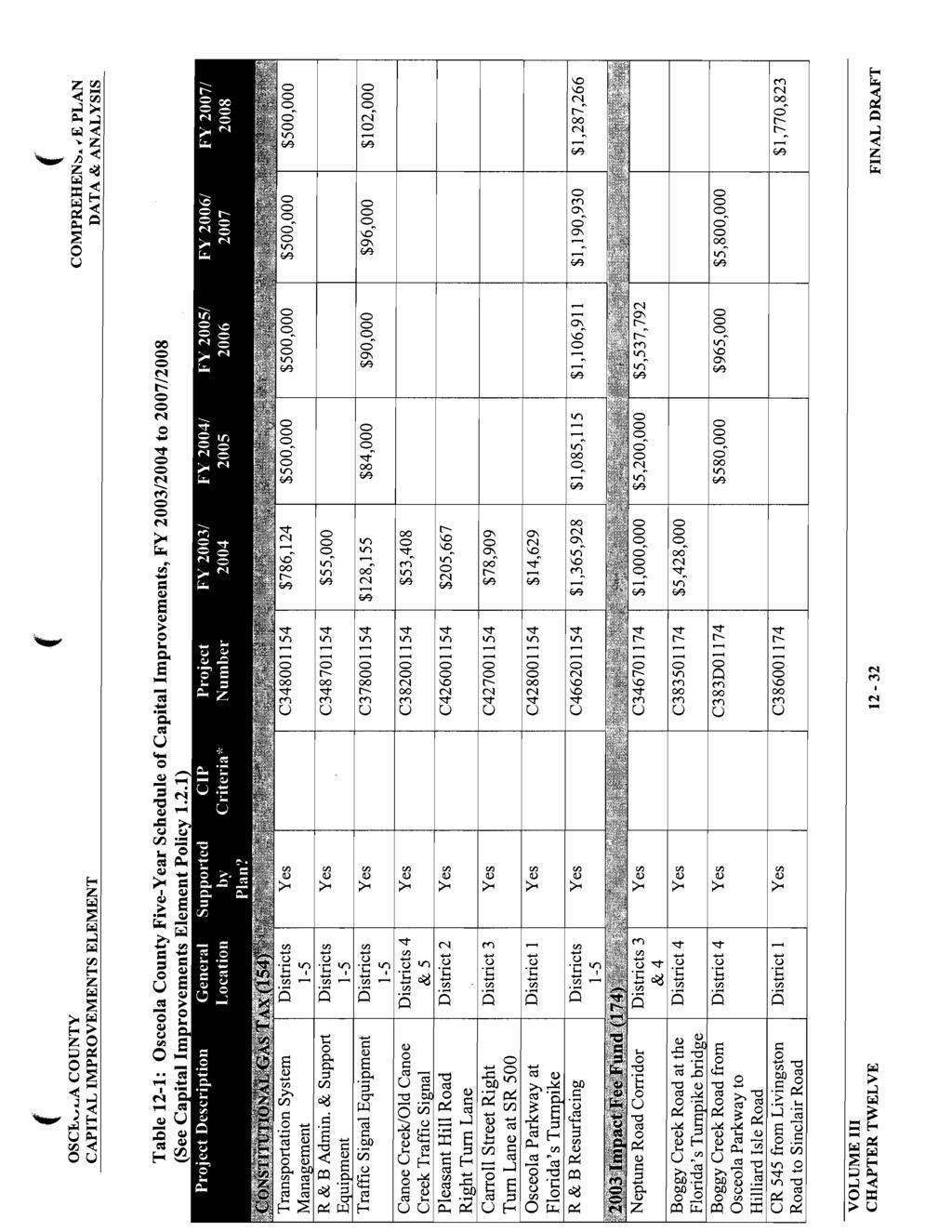
58 Table 2-: Osceola County Five-Year Schedule of Capital Improvements, FY 23/24 to 27/28 (See Capital Improvements Element Policy.2.) Project Description General Location CONSTITUTIONAL GAS TAX (54) Transportation System Management Districts 5 Supported by Plan? CIP Criteria* Project Number FY 23/ 24 FY 24/ 25 FY 25/ 26 FY 26/ 27 FY 27/ 28 Yes C34854 $786,24 $5, $5, $5, $5, R & B Admin. & Support Equipment Traffic Signal Equipment Canoe Creek/Old Canoe Creek Traffic Signal Districts 5 Districts 5 Districts 4 & 5 Yes C $55, Yes C37854 $28,55 $84, $9, $96, $2, Yes C38254 $53,48 Pleasant Hill Road Right Turn Lane Carroll Street Right Turn Lane at SR 5 Osceola Parkway at Florida s Turnpike District 2 Yes C42654 $25,667 District 3 Yes C42754 $78,99 District Yes C42854 $4,629 R & B Resurfacing Districts 5 Yes C $,365,928 $,85,5 $,6,9 $,9,93 $,287,266 4
59 Table 2-: Osceola County Five-Year Schedule of Capital Improvements, FY 23/24 to 27/28 (See Capital Improvements Element Policy.2.) Project Description 23 Impact Fee Fund (74) General Location Supported by Plan? CIP Criteria* Project Number FY 23/ 24 FY 24/ 25 FY 25/ 26 FY 26/ 27 FY 27/ 28 Neptune Road Corridor Districts 3 & 4 Yes C $,, $5,2, $5,537,792 Boggy Creek Road at the Florida s Turnpike bridge Boggy Creek Road from Osceola Parkway to Hilliard Isle Road CR 545 from Livingston Road to Sinclair Road District 4 Yes C $5,428, District 4 Yes C383D74 $58, $965, $5,8, District Yes C38674 $,77,823 5
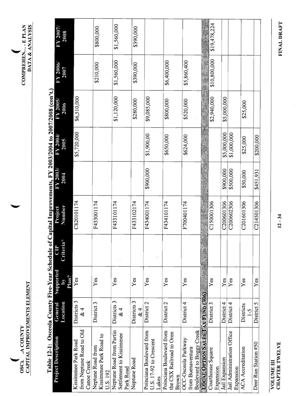
60 Table 2-: Osceola County Five-Year Schedule of Capital Improvements, FY 23/24 to 27/28 (con t.) Project Description GeneralLo Supported CIP Project FY FY 25/ cation by Plan? Criteria* FY 23/ 24/25 Number FY 26/ 27 FY 27/ 28 Osceola Parkway from Florida s Turnpike to Buenaventura Boulevard District 4 Yes C4374 $725, $4,56, OCC Osceola Parkway from John Young Parkway to U.S Districts & 3 Yes C4574 $322,38 $,7,45 Poinciana Boulevard from Crescent Lakes to P.H. Road Canoe Creek Road from Harvey Road to East of School Neptune Road at the Broadway Intersection Pleasant Hill Road from Stewart Boulevard to U.S District 2 Yes C4674 $2,493,72 District 5 Yes C4774 $2, District 3 Yes C42274 $92,25 District 2 Yes C42874 $5, $85, 6
61 Project Description GeneralLo cation Supported by Plan? CIP Criteria* Project Number FY 23/ 24 FY 24/25 FY 25/ 26 FY 26/ 27 FY 27/ 28 Sherberth Road and Black Lake Road Intersection Improvements Bill Beck Boulevard from Osceola Parkway to Woodcrest Boggy Creek Road from Osceola Parkway to Boggy Creek Road District Yes C43574 $,5, District 4 Yes C46774 $75, $,725, District 4 Yes C774 $2,, $3,983, John Young Parkway from Carroll Street to Orange County Line Districts & 3 Yes C7274 $2,75, $2,, 7
62 Table 2-: Osceola County Five-Year Schedule of Capital Improvements, FY 23/24 to 27/28 (con t.) General Supported CIP Project FY 24/ FY 25/ Project Description by Criteria* FY 23/ Location Number 24 Plan? FY 26/ 27 FY 27/ 28 Kissimmee Park Road from Neptune Road to Old Canoe Creek Districts 3 & 4 Yes C8274 $5,72, $6,5, Neptune Road from Kissimmee Park Road to U.S. 92 District 3 Yes F43374 $2, $8, Neptune Road from Partin Settlement to Kissimmee Park Road Districts 3 & 4 Yes F43374 $,2, $,56, $,56, Neptune Road Districts 3 & 4 Yes F $28, $39, $39, Poinciana Boulevard from U.S to Crescent Lakes Poinciana Boulevard from the CSX Railroad to Oren Brown District 2 Yes F43474 $9, $,9, $9,85, District 2 Yes F43474 $65, $8, $6,4, 8
63 Project Description GeneralLo cation Supported by Plan? CIP Criteria* Project Number FY 23/ 24 FY 24/25 FY 25/ 26 FY 26/ 27 FY 27/ 28 OCC Osceola Parkway from Buenaventura Boulevard to Boggy Creek District 4 Yes F7474 $624, $52, $5,86,4 LOCAL OPTION SALES TAX FUND (36) Courthouse Square Expansion District 3 Yes C536 $2,94, $,8, $9,478,224 Jail Expansion District 4 Yes C2636 $9, $5,, $5,, Jail Administration Office Expansion District 4 Yes C26236 $5, $,, ACA Accreditation Districts 5 Yes C2636 $5, $25, $25, Deer Run Station #5 District 5 Yes C24536 $45,93 $2, 9
64 Table 2-: Osceola County Five-Year Schedule of Capital Improvements, FY 23/24 to 27/28 (con t.) Project Description General Supported CIP Project FY 24/ FY 25/ Location by Criteria* FY 23/ Number 24 Plan? FY 26/ 27 FY 27/ 28 Fire Station Engineering and Architecture Districts 5 Yes C29536 $66,3 Renovate Lyndfields Fire Station District Yes C22436 $5, West 92 Fire Station District Yes C22636 $7, ChampionsGate Fire Station District Yes C22736 $75, $525, Harmony Fire Station District Yes C22836 $7, Joint School Board/County Commission Fire and EMS Equipment Districts 5 Districts 5 Yes C $,563,365 Yes C2736 $2,65,885 $,95, $,52, $,335, $7, Carroll Street and John Young Parkway Intersection District 3 Yes C2TBD36 $,26, 2
65 Table 2-: Osceola County Five-Year Schedule of Capital Improvements, FY 23/24 to 27/28 (con t.) Project Description GeneralLo Supported CIP Project FY FY 25/ cation by Plan? Criteria* FY 23/ 24/25 Number FY 26/ 27 FY 27/ 28 Boggy Creek Basin Districts, 4 & 5 Yes C3636 $29, $8, $3, Countywide Stormwater Plan Culverts, Ditches, and Easement Sheriff s Vehicles Districts 5 Districts 5 Districts 5 Yes C3836 $25, Yes C33236 $388,465 $95, $95, $95, $95, Yes C $,5, $,, $,7, $,22, $,27, Neptune Road Corridor Districts 3 & 4 Yes C $,899,854 New Library Site District Yes C $55, $3,45, Bass Slough Basin Districts, 3 & 4 Yes C3836 $36,287 $3, $35, Poinciana APV Sidewalks District Yes C38736 $45, $6, $5, $7, $4, 2
66 Table 2-: Osceola County Five-Year Schedule of Capital Improvements, FY 23/24 to 27/28 (con t.) Project Description General Supported CIP Project FY 24/ FY 25/ Location by Criteria* FY 23/ Number 24 Plan? FY 26/ 27 FY 27/ 28 West New Nolte Road from Pine Chase to Michigan Avenue District 5 Yes C42336 $ Countywide Streetlights Districts 5 Yes C43236 $25, $25, $25, $25, $25, Sherberth Road and Black Lake Road Intersection Improvements Road and Bridge Equipment Repair Shop Warehouse District Yes C43536 $587,68 District 4 Yes C $56,483 County Sidewalks Road & Bridge Equipment Districts 5 Districts 5 Yes C $84,66 $5, $5, $5, $5, Yes C $,95,375 $7, $7, $7, $7, 22
67 Table 2-: Osceola County Five-Year Schedule of Capital Improvements, FY 23/24 to 27/28 (con t.) Project Description General Supported CIP Project FY 24/ FY 25/ Location by Criteria* FY 23/ Number 24 Plan? FY 26/ 27 FY 27/ 28 Concurrency Management Agreement (Celebration and RCID) Station #9 Refurbishment (Kenansville) New Poinciana Station #4 District Yes C52736 $82, $82, $82, $82, $82, District 5 Yes C6636 $435,47 $2, District 2 Yes C69536 $4, Children s Home District 3 Yes C6536 $25, $2,95, Dirt Road Stabilization Districts 5 Yes C7236 $682,83 $5, $5, $5, $5, Boggy Creek Road from Osceola Parkway to Boggy Creek Road District 4 Yes C736 $,4,39 23
68 Table 2-: Osceola County Five-Year Schedule of Capital Improvements, FY 23/24 to 27/28 (con t.) Project Description General Supported CIP Project FY 24/ FY 25/ Location by Criteria* FY 23/ Number 24 Plan? FY 26/ 27 FY 27/ 28 Bass Road from U.S. 92 to Bass Road Disposal Facility District Yes C7436 $,657,657 Four Corners Park Library District Yes C72536 $,, Book Mobile Districts 5 Yes C73536 $2, Valencia Library District 4 Yes C74536 $,25, $,25, $,25, $,25, Greenways and Trails Districts 5 Yes C72936 $8, $8, $8, $8, Four Corners Park District Yes C76336 $, $6, $65, $5, Park Expansion District Yes C76436 $,5, South St. Cloud Community Park West U.S. 92 Community Park District 5 Yes C76636 $5, $5, $2, District Yes C76736 $,, $,, 24
69 Table 2-: Osceola County Five-Year Schedule of Capital Improvements, FY 23/24 to 27/28 (con t.) Project Description General Supported CIP Project FY 24/ FY 25/ Location by Criteria* FY 23/ Number 24 Plan? FY 26/ 27 FY 27/ 28 Road and Bridge & Parks Office Building Canoe Creek Road Neighborhood Park District 4 Yes C76836 $3, $8, $96, District 5 Yes C76936 $, $6, $65, Kissimmee Park Road from Neptune Road to Old Canoe Creek Road Districts 3 & 4 Yes C8236 $,55,982 Tax Collector Beaumont Improvements Interjurisdicational Communication Center District 3 Yes C9236 $445,572 District Yes C95236 $4, $2,6, Animal Control Kennel District 4 Yes CTB236 $24, Vehicle Maintenance Facility District Yes CTBD36 $3,, 25
70 Table 2-: Osceola County Five-Year Schedule of Capital Improvements, FY 23/24 to 27/28 (con t.) General Supported CIP Project FY 24/ FY 25/ Project Description by Criteria* FY 23/ Location Number 24 Plan? FY 26/ 27 FY 27/ 28 Relocate Kissimmee Depot Community Center in Holopaw District 3 Yes CTBD336 $4, District 5 Yes CTBD436 $ Tool Rooms District Yes CTBD536 $2, Court Admin Buildout District 3 Yes CTBD636 $87,5 Michigan Avenue from St. Cloud to 7 th Street District 5 Yes F $3,5 $,6, Hoagland Boulevard/Pleasant Hill Road Corridor Study Districts & 2 Yes F736 $5, Shingle Creek Recreational Preserve District 5 Yes F72836 $63,7 BOATING IMPROVEMENT FUND (32) New Boat Ramp Facilities Districts 5 Yes C25332 $63,675 $47,876 $35, 26
71 Table 2-2: Projections of Ad Valorem Tax Revenues Year Projected Taxable Value Millage Rate Projected Revenue (in thousands) 2 $972, $3,444,353 2 $983, $3,77, $,25, $3,867, $,67, $4,26,77 24 $,, $4,86,5 25 $,52, $4,345, $,94, $4,54,873 Notes: Includes Centrally Assessed and Real Property and Tangible Personal Property. Does not include special assessments. Source: Osceola County 27
72 Table 2-3: Projections of Non-Ad Valorem Tax Revenues FUND FY 2 22 FY FY FY FY Local Option Gas Tax (Transportation Improvement Fund) Transportation Impact Fee Fund (T.I.F.F.) Water & Sewer Utility Enterprise Fund (U.E.F.) Stormwater Utility Fund (S.U.F.) Solid Waste / Recycling $226, $233,342 $24,347 $249,352 $257,358 $468,5 $399,488 $392,335 $385,82 $378,29 $6,353,556 $6,962,874 $7,422,74 $7,65,675 $7,88,275 $35, $36,542 $37,943 $38,345 $389,747 $,54, $,5,35 $,5,348 $.52,38 $,53,42 Local Sales Tax $2,28,885 $2,9,752 $2,335,748 $2,48,744 $2,625,739 Total Revenues $,956,94 $,649,33 $2,273,795 $2,668,678 $3,63,56 Source: Osceola County 28
73 Table 2-4: Projections of Debt Services Obligation for Outstanding Bond Issues FUND FY 2 22 FY FY FY FY General Fund $,23, $,34,868 $,42,56 $,46,73 $,54,45 Water & Sewer Debt Service Total Debt Service (All City Bonded Debt) $,976,52 $,977,5 $,976,4 $,976,859 $,979,7 $2,999,53 $3,2,369 $3,8,674 $3,23,562 $3,33,36 Source: Osceola County Table 2-5: Projection of Debt Capacity Year Projected Taxable Value Debt Capacity () 2 $983,332, $47,499,8 22 $,25,6, $53,84, 23 $,67,868, $6,8,2 24 $,,37, $66,52,55 25 $,52,45, $72,86,75 26 $,94,673, $79,2,95 Source: Osceola County and Land Design Innovations, Inc., Oct. 2. Includes Centrally Assessed and Real Property and Tangible Personal Property. Does not include special assessments. Note: () Maximum debt will not exceed 5% of the City s property tax base valuation. 29
74 Table 2-6: Projection of Operating Costs FUND FY 2 2 FY 22 3 FY 23 4 FY 24 5 FY 25 6 Drainage $342, $359, $377, $395,9 $45,7 Water & Sewer $5,962, $6,26, $6,573, $6,9,6 $7,246,7 Transportation $5,3 $53,9 $56,6 $59,4 $62,4 Solid Waste $,28, $,278,9 $,324,8 $,4, $,48,5 Parks $,334,7 $,4,4 $,47,5 $,545, $,622,3 Totals $8,98, $9,353,3 $9,82, $,32, $,827,6 Source: Osceola County, 2. 3
75 Table 2-7: Projected Total Expenditures by Fund FUND FY 2 22 FY FY Transportation Improvement Fund Local Option Gas Tax FY FY Projects $45, 4222, $8, $222, $8, Operating Expenses $5,3 $53,9 $56,6 $59,4 $62,4 Total Fund Expenditures $96,3 $275,9 $236,6 $28,4 $242,4 Transportation Impact Fee Projects $73, $85, $. $25, $. Operating Expenses $. $. $. $. $. Total Fund Expenditures $73, $85, $. $25, $. Water & Sewer Utility Enterprise Fund Projects $66, $95, $,5, $35, $625, Operating Expenses $5,962, $6,26, $6,573, $6,9,6 $7,246,7 Total Fund Expenditures $6,568, $7,65, $7,588, $7,25,6 $7,87,7 Stormwater Utility Fund Projects $4, $9, $62, $93, $32, Operating Expenses $342, $359, $377, $395,9 $45,7 Total Fund Expenditures $382, $55, $539, $588,9 $547,7 Water & Sewer Utility R&R Projects $2, $6, $6, $6, $6, Operating Expenses $. $. $. $. $. Total Fund Expenditures $2, $6, $6, $6, $6, Total All Expenditures $7,996,3 $8,957, $8,479,7 $8,487,9 $8,777,8 Source: Osceola County 3
76 Table 2-8 Inventory of Public Schools ID # (Map 2 Public Schools School Acres Enrollment Capacity Portable Student Stations Student Capacity (%) Boggy Creek Elementary Central Avenue Elementary Cypress Elementary Deerwood Elementary Hickory Tree Elementary Highlands Elementary Kissimmee Elementary Lakeview Elementary Michigan Avenue Elementary Mill Creek Elementary Pleasant Hill Elementary Reedy Creek Elementary Ross E. Jeffries Elementary Thacker Avenue Elementary Ventura Elementary Celebration School (K 2) Discovery Intermediate (4 8) Narcoossee Community (K 8)
77 ID # (Map 2 School Acres Enrollment Capacity Portable Student Stations Student Capacity (%) 9 Denn John Middle Horizon Middle Kissimmee Middle Neptune Middle Parkway Middle Saint Cloud Middle Gateway High Osceola High TECO Poinciana High Saint Cloud High
78 Table 2-: Projections of Ad Valorem Tax Revenues (in dollars) Year Projected Taxable Value Millage Rate Projected Revenue (in thousands $) 29 26,399, ,23, ,42, ,594,8 2 26,48, ,87, ,93, ,25, ,28, ,9, ,42, ,776, ,883, ,887,787 Notes: Includes Countywide ad valorem taxes. Does not include special assessments. Source: Osceola County Office of Management and Budget, 28 34
79 Table 2-2: Projections of Non-Ad Valorem Tax Revenues and Fund Expenditures (in dollars) FUND FY FY 29 2 FY 2 2 FY 2 22 FY Total Transportation Impact Fee Fund (T.I.F.) Transportation Impact Fee Balance Brought Forward 9,5, 2,85, 2,687,55 2,38,77 2,947,422 3,528,49 9,, 3,38,36 585,74 2,965,38 Interest 2,246,495 35, ,32 372, ,8 3,76,988 Less Five Percent (,87,325) (,2,824) (,52,479) (,84,53) (,6,575) (5,362,256) Contributions from Private Sources 75, 75, 75, 75, 75, 3,75, Bond Proceeds 82,, 3,, 5,, 37,, Other Funding Sources 65,, 55,, 2,, Grants 8,, 8,, 35
80 Table 2-2: Projections of Non-Ad Valorem Tax Revenues and Fund Expenditures (in dollars) FUND FY FY 29 2 FY 2 2 FY 2 22 FY Total Transfer In from LOST TOTAL T.I.F. REVENUES Transfer Out General Fund Transfer Out Transportation Trust Fund 2,4, 2,4, 2,4, 2,4, 2,4, 2,, 22,89,7 55,944,97 28,732,77 88,747,7 79,364, ,598,26 29,863 29,863 3,356 32, ,57 58,576,67,25,67,25,746,58,886,37 2,37,22 8,94,5 36
81 Table 2-2: Projections of Non-Ad Valorem Tax Revenues and Fund Expenditures (in dollars) FUND FY FY 29 2 FY 2 2 FY 2 22 FY Total Transfer Out Growth Management Transfer Out Debt Service Total All Project Requests Reserve for Future Debt Service 292,5 43, , ,92 4,568,89,9 5,432,439 5,7,9 5,7,22 5,64,962 5,64,46 26,3,8 5,95,52 3,388,346 93,397,668 53,329,82 4,775,77 423,86,738 6,86,75 7,74,8 26,526,348 26,526,348 26,5256,348 4,8,767 Designated Reserves 3,38,36 585,74,47,455,4,754 4,425,53,273,642 TOTAL T.I.F. EXPENDITURES 22,89,7 55,944,97 28,732,77 88,747,7 79,364, ,598,26 Local Option Infrastructure Sales Tax Fund (L.O.S.T.) Local Option Infrastructure Sales Tax 2,476,9 2,9,392 2,723,4 22,374,797 23,46,4 8,7,443 37
82 Table 2-2: Projections of Non-Ad Valorem Tax Revenues and Fund Expenditures (in dollars) FUND FY FY 29 2 FY 2 2 FY 2 22 FY Total Balance Brought Forward 3,85, 2,459,67 34,588,63,357 74,285 7,78,9 Interest 649,943 65, 65, 65, 65, 3,249,943 Misc. Revenue Reimbursements 3, 3, 3, 3, 3, 5, Less Five Percent (,57,83) (,88,52) (,2,55) (,52,74) (,86,32) (5,65,59) Bond Proceeds 95,, 45,, 4,, 8,, Other Funding Sources Transfer In from General Fund TOTAL L.O.S.T. REVENUES 7,,,7, 27,7, 2,293,867,,,,,,,, 52,293,867 3,242,6 78,4,542 7,47,537 5,65,44 43,44,24 374,28,634 Principal & Interest 89,345 89,345 89,743 88,886 88,535 4,95,854 Transfer Out General Fund 4,365 4,365 4,583 4,82 5,53 23,78 38
83 FUND FY FY 29 2 FY 2 2 FY 2 22 FY Total Balance Brought Forward,47,6 2,985,644 3,95,46 735,39 6,326 7,879,9 Interest 58,44 98,334,689 55,68 42, ,672 Less Five Percent (96,664) (,47) (4,535) (5,28) (7,633) (55,52) Other Funding Sources Transfer In from LOST TOTAL P.I.F. REVENUES Transfer Out Growth Management Total All Project Requests 3,6, 3,6, 2, 2, 2, 2, 2,,5, 3,93,766 5,23,583 5,29,622 6,544,448 2,27,36 22,324,779 28,22 28,22 28,22 28,22 28,22 4,6 8, 2,, 4,528,9 6,5, 2,, 5,8,9 Designated Reserves 2,985,644 3,95,46 735,39 6, ,238 7,75,978 TOTAL P.I.F. EXPENDITURES 3,93,766 5,23,583 5,29,622 6,544,448 2,27,36 22,324,779 39
84 Table 2-2: Projections of Non-Ad Valorem Tax Revenues and Fund Expenditures (in dollars) FUND FY FY 29 2 FY 2 2 FY 2 22 FY Total Transfer Out to New Impact Fees 2,4, 2,4, 2,4, 2,4, 2,4, 2,, Transfer Out Parks 2, 2, 2, 2, 2,,5 Transfer Out Debt Service Total All Project Requests Reserve for Future Debt Service 8,96,259 4,863,393 5,25,273 4,7, 4,7, 24,88,666,25,427 55,222,485 47,894,368 27,53,945 2,26,22 26,935,427,459,96 4,225,486 4,225,486 4,225,486 4,225,486 67,36,86 Designated Reserves 2,459,67 34,588,63,357 74, ,748 4,725,648 TOTAL L.O.S.T. EXPENDITURES 3,242,6 78,4,542 7,47,537 5,65,44 43,44,24 374,28,634 Park Impact Fee Fund (P.I.F.) Park Impact Fees,874,83,93,75,989,77 2,48,677 2,,38 9,953,727 Source: Osceola County Office of Management and Budget, 28 4
85 Table 2-3: Projections of Debt Services Obligation for Outstanding Bond Issues (in dollars) FUND FY FY 29 2 FY 2 2 FY 2 22 FY ½ Local Government Sales Tax 4,77,655 4,75,45 4,79,955 4,78,25 4,77,625 Gas Taxes 2,93,896 2,94,72 2,663,6 2,654,675 2,66,2 Infrastructure Sales Tax Limited Ad Valorem (Save Osceola) Tourist Development Tax,259,757,248,76,244,53,234,79,23,249,85,66,83,229,85,447,8,23,79,923 4,89,783 4,888,656 4,886,22 4,884,66 4,882,439 Total Debt Service 23,445,257 23,4,78 23,59,85 23,32,598 23,3,436 Source: Osceola County Office of Management and Budget, 28 4
86 Table 2-4: Projection of Debt Capacity (in dollars) Year Projected Available Revenues () Debt Capacity (2) 29 35,47,69 498,3, 2 36,22,2 53,249, 2 37,288,85 528,646, ,46,83 544,55, ,559,35 56,84,4 Source: Osceola County Office of Management and Budget, 28 Note: () This analysis should not be used in the aggregate. The capacity for each year is based on a 3% increase in pledged revenue streams and must be adjusted on a yearly basis as actual bonds are issued. Each year shows maximum capacity assuming that no bonds were issued in the previous period. (2) All Board approved revenue sources and the voter approved Infrastructure Sales Tax, (Tourist development tax and limited ad valorem excluded) net of existing debt service and coverage restrictions. Some revenues (gas taxes and ½ cent sales tax) are currently being used to pay for operating expenses. 42
87 Table 2-5: Projection of Operating Costs (in dollars) FUND FY 28 9 FY 29 FY 2 FY 2 2 FY 22 3 Stormwater 4,4 4,729 3, 6,5 3, Transportation,692,7,45,7 787,247 49,57 8,537 Parks And Recreation 4, 95,5 764,98 35, 35, Totals 2,6,47 2,325,299,555,55 848,7 534,537 Source: Osceola County Office of Management and Budget, 28 43
88 Table 2 6: Funding Sources for Parks Projects (in dollars) FUND SOURCE FY FY 29 2 FY 2 2 FY 2 22 FY TOTAL Local Option Infrastructure Sales Tax 4,, 7,55, 2,49,77,5, 4,84,77 Park Impact Fees 2,, 4,528,9 5,5, 2,, 4,28,9 Total 4,, 9,55, 4,528,9 6,649,77 3,5, 28,832,268 Source: Osceola County Office of Management and Budget, 28 Table 2 7: Funding Sources for Stormwater Projects (in dollars) FUND FY FY 29 2 FY 2 2 FY 2 22 FY TOTAL Local Option Infrastructure Sales Tax 44,,472, 3, 65, 3, 3,62, Source: Osceola County Office of Management and Budget, 28 44
89 Table 2 8: Funding Sources for Transportation Projects (in dollars) FUND SOURCE FY FY 29 2 FY 2 2 FY 2 22 FY TOTAL Local Option Infrastructure Sales Tax Transportation Impact Fee Fund 68,462,49 9,432,42,299,55 24,985,578 23,79,84 22,89,7 55,944,97 28,732,77 88,747,7 79,364, ,598,26 Total 9,27,579 75,377,2 39,3,332 3,732,595 79,364, ,777,445 Source: Osceola County Office of Management and Budget, 28 45
90 Table 2 9: Comparison of Local Option Infrastructure Sales Tax Fund and Proposed Capital Project Expenditures (in dollars) YEAR FY FY 29 2 FY 2 2 FY 2 22 FY TOTAL Local Option Infrastructure Sales Tax Fund Park LOST Funded Projects Stormwater LOST Funded Projects Transportation LOST Funded Projects 3,242,6 78,4,542 7,47,537 5,65,44 43,44,24 374,28,634 4,, 7,55, 2,49,77,5, 4,84,77 44,,472, 3, 65, 3, 3,62, 68,462,49 9,432,42,299,55 24,985,578 23,79,84 Surplus (Deficit) 58,239,77 5,82,5 6,88,382 22,28,759 4,64,24 233,35,373 Source: Osceola County Office of Management and Budget, 28 46
91 Table 2 : Comparison of Transportation Impact Fee Fund and Proposed Capital Project Expenditures (in dollars) YEAR FY FY 29 2 FY 2 2 FY 2 22 FY TOTAL Transportation Impact Fee Fund 22,89,7 55,944,97 28,732,77 88,747,7 79,364, ,598,26 Transportation Impact Fee Funded Projects 99,556,93 9,338,59 83,,6 54,969,324 8,38, ,3,72 Surplus (Deficit) 23,253,77 36,66,46 45,63,7 33,777,693 6,226,239 2,494,54 Source: Osceola County Office of Management and Budget, 28 Table 2 : Comparison of Park Impact Fee Fund and Proposed Capital Project Expenditures (in dollars) YEAR FY FY 29 2 FY 2 2 FY 2 22 FY TOTAL Park Impact Fee Fund Park Impact Fee Funded Projects 3,93,766 5,23,583 5,29,622 6,544,448 2,27,36 22,324,779 2,, 4,528,9 5,5, 2,, 4,28,9 Surplus (Deficit) 3,93,766 3,23, ,43,44,448 27,36 8,296,588 Source: Osceola County Office of Management and Budget, 28 47
92 ROADWAY SEGMENT ANALYSIS As part of the CIE update, Osceola County Traffic Engineering performed an analysis of the roadway segments within the County that are currently monitored within the Concurrency Management System (Table 23 Projected Roadway Capacity Analysis). The analysis applied five year growth factors to each of the roadway segments to project the background traffic for the year 23. Based upon that analysis, it was determined that 24 roadway segments are projected to operate below their adopted Level-of-Service (LOS) in the Year 23. Listed below is a description of the 24 roadway segments projected to operate below their adopted LOS and a description of how those roadways will be relieved. Map, Roadway Segments Projected to operate Below Adopted Level of Service in Year 23, illustrates the location of the 24 roadway segments. Construction of roadway projects currently within the Five-Year Capital Improvements Plan (CIP) will allow the County to develop an alternative traffic circulation network and to divert traffic away from the roadway segments projected to operate below the adopted LOS in the year 23. Completion of the roadway projects and development of an alternative traffic circulation network is result in the 24 roadways operating at acceptable level-of service standards by 23.. Boggy Creek Road from Buenaventura Boulevard to Simpson Road The construction of the Bill Beck Boulevard extension from Boggy Creek Road to Osceola Parkway will divert traffic off of the roadway segment of Boggy Creek Road from Buenaventura Boulevard to Simpson Road. This roadway construction project is listed within the County s Five-Year Schedule of Capital Improvements. Construction of this roadway will provide an alternative north-south route in the roadway network and will reduce traffic volumes on Boggy Creek Road. Additionally, the construction of Narcoossee Road from U.S. Highway 92 to the Orange County Line as a four-lane section will divert traffic off of Boggy Creek Road also, and it will provide an improved additional north-south route. 2. Carroll Street from Hoagland (at Columbia) to Dyer Boulevard The construction of John Young Parkway from Carroll Street to the Orange County Line as a four-lane section, as well as the construction of a grade separated interchange at the intersection of John Young Parkway and Osceola Parkway, will divert traffic off of Carroll Street. This roadway construction project is listed within the County s Five-Year Schedule of Capital Improvements. Additionally, the developer of the Tapestry Development of Regional Impact (DRI), which includes property directly adjacent to Carroll Street, is required, as a part of the development order, to construct the fourlane improvement of Carroll Street from Columbia Avenue to Thacker Avenue. 48
93 3. Clay Street from Thacker Avenue to Pleasant Hill Road The construction of Hoagland Boulevard from U.S. Highway 92 to U.S. Highway 7-92 as a four-lane section, as well as the realignment of existing curves, will divert traffic off of Clay Street and provide an additional improved north-south route to U.S. Highway 92. Additionally, improvements to the intersection of Pleasant Hill Road and U.S. Highway 7-92 will divert traffic off of Clay Street and onto U.S. Highway 7-92, thus creating an additional route north to U.S. Highway 92. Both of these roadway construction projects are listed within the Five-Year Schedule of Capital Improvements. Clay Street is currently scheduled for a four-lane improvement in the Year Cypress Parkway from Marigold Avenue to Pleasant Hill Road The developer-funded construction of the Poinciana Parkway from Marigold Avenue to U.S. Highway 7-92 in Polk County is projected to significantly reduce the traffic volumes on Cypress Parkway and Pleasant Hill Road. Additionally, improvements of the intersection of Pleasant Hill Road and U.S. Highway 7-92 will improve traffic flows and volumes along this roadway segment, which feeds into Cypress Parkway to the south. Cypress Parkway is currently scheduled for a six-lane improvement in the Year Florida Turnpike from Orange County Line to U.S. Highway Exit This limited access roadway is maintained and operated by the Florida Turnpike Enterprise and they are responsible for the assignment and scheduling of all major improvements for these roadways. Improvements to the Florida Turnpike would appear in the Metroplan Transportation Improvement Plan. 6. Hoagland Boulevard/Pleasant Hill Road from U.S. Highway 7-92 to U.S. Highway 92 There is a joint-project agreement between the City of Kissimmee, Osceola County and the Florida Department of Transportation (FDOT) for the construction of this roadway as a four-lane section and the realignment of the existing roadway. This roadway construction project is within the Five-Year Schedule of Capital Improvements. 7. Interstate-4 from U.S. Highway 92 to the Orange County Line This limited access roadway is maintained and operated by the FDOT. The FDOT is responsible for the assignment and scheduling of all major improvements for this roadway segment. The proposed commuter rail for the Orlando metropolitan area will help to reduce the traffic on this major thoroughfare, which is the primary commuting route to and from the downtown Orlando Central Business District. 49
94 8. Lakeshore Boulevard from Partin Settlement Road to Brown Chapel Road This roadway segment is constrained to a two-lane section due to residential development and a park facility. The construction of Simpson Road from U.S. 92 to Fortune Road as a four-lane section will divert traffic off of Lakeshore Boulevard and provide an additional route to Boggy Creek Road. This roadway construction project is within the Five-Year Schedule of Capital Improvements. 9. Marigold Avenue from Cypress Parkway to Koa Street This roadway is within the Poinciana Overlay District and will be widened to a four-lane section as part of the Poinciana Parkway Agreement. This northsouth directional roadway will connect to Poinciana Parkway to the north. Poinciana Parkway will operate as a private toll road facility.. Mill Slough Boulevard from Michigan Avenue to Bill Beck Boulevard The construction of the Bill Beck Boulevard extension from Boggy Creek Road to Osceola Parkway will divert traffic off of the roadway segment of Mill Slough Boulevard from Michigan Avenue to Bill Beck Boulevard. This roadway construction project is within the Five-Year Schedule of Capital Improvements. Mill Slough Boulevard is presently being used to access Michigan Avenue to head north to Osceola Parkway or south to U.S. Highway 92. The construction of the Bill Beck Extension will provide an alternative north-south route in the roadway network and will reduce traffic volumes on Mill Slough Road.. Oak Street from Main Street to U.S. Highway (Vine Street) This roadway segment is currently within the City of Kissimmee Five-Year CIP for construction as a four-lane section from Main Street to U.S. Highway Osceola Parkway from U.S. Highway (Orange Blossom Trail) to The Florida Turnpike The roadway segment of Osceola Parkway from U.S. Highway to the Florida Turnpike is currently a six-lane facility and is geometrically constrained. The intersection of Osceola Parkway and U.S. Highway (Orange Blossom Trail) is currently scheduled for an interchange improvement in the Year Osceola-Polk Line Road from U.S. Highway 7-92 to Old Lake Wilson Road The developer-funded construction of the Poinciana Parkway from Marigold Avenue to U.S. Highway 7-92 in Polk County is projected to reduce the traffic volumes on Osceola-Polk Line Road. Additionally, the widening of State Road 54 in Polk County will divert traffic off of Osceola-Polk Line Road and assist in the reduction of traffic volumes on this roadway. Osceola- 5
95 Polk Line Road is currently scheduled for a four-lane improvement in the Year Partin Settlement Road from Neptune Road to U.S. Highway (Bronson Highway) The construction of Neptune Road from Westchester Drive to Old Canoe Creek Road as a four-lane section will divert traffic off of Partin Settlement Road and will provide an improved northwest to southeast route from Saint Cloud to Kissimmee. Additionally, the five-lane improvement of Shady Lane from U.S. Highway 92 to Partin Settlement Road, as well as the new Shady Lane Extension, from Neptune Road to Partin Settlement Road, will provide additional roadway network improvements in this area and will reduce traffic volumes on the segment of Partin Settlement Road from Neptune Road to U.S. Highway 92. All of these roadway construction projects, including the Shady Lane Extension, are included within the Five-Year Schedule of Capital Improvements. 5. Sherberth Road from U.S. Highway 92 to the Orange County Line The roadway segment of Sherberth Road from U.S. Highway 92 to the Orange County Line is currently a two-lane facility, and the intersection of U.S. Highway 92/Black Lake Road and Sherberth Road is geometrically constrained. Future multi-modal transportation improvements in the West U.S. Highway 92/Four Corners Area will assist with the reduction of traffic volumes in this area. 6. SR 535 (Vineland Road) from U.S. Highway 92 to the Orange County Line A coordinated effort between Osceola County, Orange County and FDOT is currently developing a -year Concurrency Monitoring System for this roadway segment of State Road (S.R.) 535 from U.S. Highway 92 to the Orange County Line. This roadway is scheduled for a six-lane future improvement that could potentially be funded by mitigation funds from future developments along the corridor. This roadway is maintained and operated by the FDOT and FDOT is responsible for the assignment and scheduling of all major improvements along this roadway segment. 7. Thacker Avenue from Clay Street to Martin Luther King Boulevard The construction of Hoagland Boulevard from U.S. Highway 92 to U.S. Highway 7-92 as a four-lane section, as well as realignment of the curves, will divert traffic off of Thacker Avenue and provide an additional improved north-south route to U.S. Highway 92 to the north. Additionally, improvements of the intersection of Pleasant Hill Road and U.S. Highway 7-92 will divert traffic off of Thacker Avenue and onto U.S. Highway Both of these roadway construction projects are within the Five-Year Schedule of Capital Improvements. 5
96 8. U.S. Highway 92 from Lake County Line to SR 429 Western Beltway This roadway is maintained and operated by the FDOT and FDOT is responsible for the assignment and scheduling of all major improvements for this roadway segment. Future developer improvements to Funie Steed Boulevard will provide an additional east-west roadway network improvement and will divert traffic from the roadway segment of U.S. Highway 92 from Lake County Line to SR 429 Western Beltway, to Funie Steed Road. 9. U.S. Highway 92 from SR 429 Western Beltway to I-4 The roadway segment of U.S. Highway 92 from the State Road 429 Western Beltway to Interstate-4 is currently a six-lane facility and is geometrically constrained. Future ITS and Multi-Modal improvements are currently being planned, in conjunction with FDOT, for this corridor. 2. U.S. Highway from Michigan Avenue to Boggy Creek Road The roadway segment of U.S. Highway from Michigan Avenue to Boggy Creek Road is currently a six-lane facility and is geometrically constrained. Future Multi-Modal improvements are currently being planned, in conjunction with FDOT, for this corridor. 2. U.S. Highway from Shady Lane to Partin Settlement Road This roadway is maintained and operated by the FDOT. The FDOT is responsible for the assignment and scheduling of all major improvements for this roadway segment. A planned four-lane improvement to Neptune Road from Partin Settlement Road to U.S. Highway 92 will provide an additional northwest-southeast roadway network improvement and will divert traffic from the roadway segment of U.S. Highway 92 from Shady Lane to Partin Settlement Road, to Neptune Road. This roadway construction project is within the Five-Year Schedule of Capital Improvements. 22. U.S. Highway 7-92 from Osceola-Polk Line Road to Poinciana Boulevard This roadway is maintained and operated by the FDOT. The FDOT is responsible for the assignment and scheduling of all major improvements for this roadway segment. The developer-funded construction of the Poinciana Parkway from Marigold Avenue to U.S. Highway 7-92 in Polk County is projected to reduce the traffic volumes on U.S. Highway Additionally, the four-lane improvement of Poinciana Boulevard from U.S. Highway 7-92 to U.S. Highway 92 will divert traffic off of the U.S. Highway 7-92 corridor from Osceola-Polk Line Road to Poinciana Boulevard. Traffic that would normally use U.S. Highway 7-92 as a route to I-4 or Old Lake Wilson Road will be able to utilize Poinciana Boulevard as an alternate route to the West U.S. Highway 92 area. 52
97 23. U.S. Highway 7-92 from Poinciana Boulevard to Ham Brown Road This roadway is maintained and operated by the FDOT. FDOT is responsible for the assignment and scheduling of all major improvements for this roadway segment. The developer-funded construction of the Poinciana Parkway from Marigold Avenue to U.S. Highway 7-92 in Polk County is projected to reduce the traffic volumes on U.S. Highway U.S. Highway 7-92 from Poinciana Boulevard to Ham Brown Road is currently projected for a fourlane improvement in the Year US 7-92 (John Young Parkway) from Pleasant Hill Road to Penfield Street This roadway is maintained and operated by the FDOT. The FDOT is responsible for the assignment and scheduling of all major improvements for this roadway segment. The construction of Hoagland Boulevard from U.S. Highway 92 to U.S. Highway 7-92 as a four-lane section, and realignment of the curves, will divert traffic off of U.S and provide an additional improved route to U.S. 92. The roadway segment of U.S from Pleasant Hill Road to U.S. 92 is planned for a six-lane improvement in the future. The Planning, Development and Engineering Study and Preliminary Engineering are currently underway for this roadway improvement. 53
98 ROAD SEGMENT FROM TO AVERAGE DAILY TRAFFIC (ADT) Peak Hour Directional Generalized Service Volumes FACTORS 23 PK 23 VOL STA. NO. COUNT SOURCE ROAD_NAME LIMITS LIMITS LENGTH (Miles) FUNC CLASS NO. LANE 2,4 2,5 2,6 2,7 2,8 23 Projected A B C D E K D HR DIR VOL EXCEEDS CAP? Improvements 2 OC ABSHER ROAD JACK BRACK ROAD CYRILS DRIVE.79 URBAN COL 2 N/A N/A N/A N/A N/A OC BASS HIGHWAY PINE GROVE RD END.2 URBAN COL 2,9 2,3 2,3 2,3 2, No 4 77 OC BASS ROAD YOWELL ROAD U.S. 92 URBAN COL 2,4 6, 6, 6,4 6,4 7, No OC BILL BECK BLVD US (BRONSON HWY) BOGGY CREEK RD.64 URBAN COL 4 DIV 5, 5, 4,6 4,6 3, ,4, No OC BOGGY CREEK ROAD BOGGY CREEK ROAD E OSCEOLA PKWY.29 PRIN ART. 2 LT 9, 9, 2,4 22,9 22, ,4, ,3 No 473 OC BOGGY CREEK ROAD OSCEOLA PKWY BUENAVENTURA BLVD.75 MINOR ART 2 LT 5,6 2,7 7, 8, 8, ,4, No OC BOGGY CREEK ROAD BUENAVENTURA BLVD SIMPSON ROAD.28 MINOR ART 5 UND 36, 4, 4, 4, 4, ,4, ,4 Yes Widen to 6 L OC BOGGY CREEK ROAD SIMPSON ROAD U.S URBAN COL 4 LT 22,5 22,5 23, 23, 25, ,53,8,86, ,27 No OC BOGGY CREEK ROAD E NARCOOSSEE RD (CR 5) AUSTIN TYNDELL PARK 3.55 MINOR ART 2 LT 6,5 7,4 7, ,3, No OC BOGGY CREEK ROAD E AUSTIN TYNDELL PARK BOGGY CREEK ROAD W 2.42 MINOR ART 2 LT 9,5,,8 3,5 2, ,3, No 6 2 Kiss BROADWAY EMMETT STREET DRURY AVENUE.36 MINOR ART 4D NO LT 3,73 3, 34,6 33,5 33, ,36,7, ,46 No 7 5 OC BROWN CHAPEL ROAD 3TH ST (U.S ) LAKESHORE BLVD.3 URBAN COL 2 LT 4, 4,5 4,3 4,5 4, No OC BUENAVENTURA BLVD OSCEOLA PKWY ORANGE COUNTY LINE.2 MINOR ART 4 DIV 28,2 28,2 28, ,53,8,86, ,227 No OC BUENAVENTURA BLVD BOGGY CREEK ROAD FLORIDA PKWY.95 MINOR ART 4 DIV 24,2 22,9 22, ,53,8,86, ,96 No OC BUENAVENTURA BLVD FLORIDA PKWY OSCEOLA PKWY.32 MINOR ART 4 DIV 28, 3, 3, 3,6 3, ,53,8,86, ,457 No 2 65 OC CANOE CREEK ROAD KEENANSVILLE SULLIVAN ROAD 26 MAJOR COL 2,4,4,3,3, , No OC CANOE CREEK ROAD SULLIVAN ROAD DEER RUN ROAD 3.56 MINOR ART 2 LT 4,4 5,2 4,8 5, 4, ,2, No OC CANOE CREEK ROAD DEER RUN ROAD OLD CANOE ROAD.8 MINOR ART 2 LT 2,2,4 9,8 2,8 2, No OC CANOE CREEK ROAD OLD CANOE ROAD NOLTE ROAD 2.2 MINOR ART 2 LT 9,2,,2 3,, No OC CANOE CREEK ROAD NOLTE ROAD U.S MINOR ART 3 2,5 3, 3,4 5,8 3, No 26 3 OC CARROLL STREET HOAGLAND (@ COLUMBIA) DYER BLVD.48 MINOR ART 2 LT 8, 8, 8, Yes Widen to 4 L OC CARROLL STREET DYER BLVD THACKER AVENUE.64 MINOR ART 2 LT 3, 2, 2, 2, 3, No OC CARROLL STREET THACKER AVENUE JOHN YOUNG PKY.58 MINOR ART 5 UND 8,8 6,6 6, 5,3 5, No 3 33 OC CARROLL STREET JOHN YOUNG PKY MAIN STREET (U.S. 44).93 MINOR ART 3 7, 5,6 5, 5, 4, No OC CARROLL STREET MAIN STREET (U.S. 44) OLD DIXIE HWY.29 MINOR ART 3 5, 5, 4,7 4,7 2, No OC CARROLL STREET OLD DIXIE HWY MICHIGAN AVENUE.49 MINOR ART 4 NO LT 3,2 3,2 3, 3, 2, ,53,8,86, No OC CELEBRATION AVENUE US 92 (BRONSON HWY) CELEBRATION BLVD..65 URBAN COL 4 DIV 3,2 6,8 5,6 6,8 5,93 839,2,62, No OC CELEBRATION BLVD. CELEBRATION PLACE WORLD DRIVE.85 URBAN COL 4 DIV 5,6 5,6 8,8 8,8 8, ,2,62, No 38 2 Kiss CENTRAL - DRURY BROADWAY (U.S. 7-92) US 92 (VINE STREET).7 URBAN COL 5 UND 9,2 9,9 3,,7,56 338,2,62, No 39 3 Kiss CENTRAL AVENUE US 92 (VINE STREET) DONEGAN AVENUE.49 URBAN COL 2,3 3, 3, 9,7 9,9 9, No 4 22 OC CHAMPIONSGATE BLVD POLK CO. I-4.6 URBAN COL 4 DIV 3,6 7, 9,5 2,6 22, ,2,62, ,588 No 4 4 Kiss CHURCH STREET MABBETTE STREET DRURY AVENUE.26 URBAN COL 2 5,3 4, 4, No 42 CLAY ST.- PENFIELD CLYDE STREET THACKER AVENUE.83 URBAN COL 2 N/A N/A N/A N/A N/A N/A OC CLAY STREET THACKER AVENUE PLEASANT HILL ROAD.89 URBAN COL 2 LT,3 2,5 3,3 3,3 2, No 44 9 Kiss COLUMBIA AVENUE THACKER AVENUE JOHN YOUNG PKY.54 URBAN COL 4 NO LT 8,8 8,6 8, 7,7 6, No 45 6 Kiss COLUMBIA AVENUE JOHN YOUNG PKY CENTRAL AVENUE.5 URBAN COL 3 4,4 3, 2,5 7,6 7, No 46 7 Kiss COLUMBIA AVENUE HOAGLAND BLVD THACKER AVENUE.2 URBAN COL 4 UND 8,8 9,7 7,7 2,3 2, No
99 ROAD SEGMENT FROM TO AVERAGE DAILY TRAFFIC (ADT) Peak Hour Directional Generalized Service Volumes FACTORS 23 PK 23 VOL STA. NO. COUNT SOURCE ROAD_NAME LIMITS LIMITS LENGTH (Miles) FUNC CLASS NO. LANE 2,4 2,5 2,6 2,7 2,8 23 Projected A B C D E K D HR DIR VOL EXCEEDS CAP? Improvements 47 Kiss COLUMBIA AVENUE CENTRAL AVENUE MAIN STREET (U.S. 44).3 URBAN COL 2 7, 7, 6,2 6,3 6, No OC CREEK WOODS DRIVE CANOE CREEK RD MICHIGAN AVE.77 URBAN COL 2 LT 3,9 4,4 4,4 4,4 4, No OC CYPRESS PARKWAY MARIGOLD AVE PLEASANT HILL ROAD.56 PRIN ART. 4 DIV 25,5 3,5 3,5 5,6 5, ,53,8,86, ,475 Yes Widen to 6 L OC CYRILS DRIVE NARCOOSSEE ROAD (CR 5)ABSHER ROAD.79 URBAN COL 2,5,3, No OC DEER PARK ROAD U.S. 92 NOVA ROAD (CR 532) 6 MINOR COL , No OC DEER RUN ROAD CANOE CREEK RD. HICKORY TREE ROAD 2.4 MINOR ART 2 7, 4, 3,8 3,8 4, No 54 2 Kiss DENN JOHN LANE US 92 (VINE ST) MILL SLOUGH ROAD.5 URBAN COL 3, 4 9, 9,8,4 9,7 9, No 55 3 Kiss DONEGAN AVENUE THACKER AVENUE JOHN YOUNG PKY.62 URBAN COL 2 LT 3,9 3,8 3,7 3,5 3, No OC DONEGAN AVENUE JOHN YOUNG PKY US (O.B.T.).73 URBAN COL 2 9, 9, 9,3,, No OC DONEGAN AVENUE US (O.B.T.) MICHIGAN AVENUE.75 URBAN COL 3 2,4 2,4 3,5 2,8 2, No OC DOVERPLUM AVENUE CYPRESS PKWY KOA STREET.7 URBAN COL 2 LT 4, 7,4 8,2 8,6 3, No OC DOVERPLUM AVENUE Old PLEASANT HILL RD CYPRESS PKWY.55 URBAN COL 2 LT 4,5 4,7 3,6 8, Yes Widen to 4 L 6 6 Kiss DYER BLVD US 92 (VINE STREET) MIDDLE SCHOOL.85 URBAN COL 3 8, 7,9 7,3 7,4 5, No 6 7 Kiss DYER BLVD AIRPORT US 92 (VINE STREET).65 URBAN COL 3 6,6 6,6 6,4 6, 7, No 62 8 Kiss DYER BLVD CARROLL ST OSCEOLA PKWY.26 URBAN COL 4 DIV 2,5 5, 5,3 5,2 9766,2,62, ,8 No OC EDEN DRIVE NOVA ROAD END. MAJOR COL 2,,3,3,3, No 64 9 Kiss EMMETT ST JOHN YOUNG PKY BROADWAY.47 MINOR ART 5 UND 26,6 28,3 3, 29,4 28, ,36,7, ,47 No OC ENTERPRISE-MERCANTILE POINCIANA BLVD HAM BROWN RD..58 URBAN COL No OC FIFTH ST., ST CLOUD VERMONT AVENUE US URBAN COL 2 4,4 4,9 4,4 4,4 4, No 67 FLORENCE VILLA GROVE RDPOLK CO. LINE WESTSIDE BLVD.5 URBAN COL UC N/A N/A N/A N/A N/A N/A OC FLORIDA PARKWAY OSCEOLA PKWY BUENAVENTURA BLVD 2.3 URBAN COL 2 LT 8, 8,3 8,5 8, No 69 2 FDOT FLORIDAS TURNPIKE OSCEOLA PKWY ORANGE COUNTY LINE.68 PRIN ART. 4 DIV 44,6 44,6 5,2 5994,22 2,2 2,74 3,24 3, ,79 Yes Widen to 6 L FDOT FLORIDAS TURNPIKE INDIAN RIVER COUNTY KISSIMMEE PARK RD 45.9 PRIN ART. 4 DIV 25,82 26,596 26,886 32, ,27 2, 2,94 3,58 3, ,744 No 7 2 FDOT FLORIDAS TURNPIKE KISSIMMEE PARK RD US EXIT 5.7 PRIN ART. 4 DIV 25,2 3,8 3797,27 2, 2,94 3,58 3, ,647 No 72 2 FDOT FLORIDAS TURNPIKE US EXIT OSCEOLA PKWY 4.2 PRIN ART. 4 DIV 56,4 62, ,27 2, 2,94 3,58 3, ,86 Yes Widen to 6 L 73 9 OC FORMOSA GARDENS BLVD. SINCLAIR ROAD FUNIE STEED ROAD 2.64 URBAN COL 4 DIV 9, 9,7 7,6 6,77 76,2,62, No 74 7 OC FORMOSA GARDENS BLVD. FUNIE STEED ROAD US 92 (BRONSON HWY).9 URBAN COL 4 DIV 9, 9,7 9,7 9,6 9,545 22,2,62, No OC FORTUNE ROAD BOGGY CREEK RD (CR 53) LAKESHORE BLVD.8 URBAN COL 2 LT 4, 4,2 4,8 4,8 6, No 76 OC FRIARS COVE ROAD FLORIDAS TURNPIKE CANOE CREEK ROAD.52 URBAN COL 2,5,5,5 N/A No 77 8 OC FUNIE STEED ROAD WESTSIDE BLVD FORMOSA GARDENS BLVD 2.6 URBAN COL 2 LT 3, 4,4 5,5 5,2 5, No 78 2 OC FUNIE STEED ROAD FORMOSA GARDENS BLVD OLD LAKE WILSON RD.8 URBAN COL 2 LT,,, No 79 2 OC GOODMAN ROAD TRI-COUNTY ROAD WESTSIDE BLVD 3.78 URBAN COL 2 8 8, ,3, No 8 Cel. GRIFFIN ROAD U.S. 92 WORLD DRIVE.95 URBAN COL 2,2 2, 2, N/A N/A N/A N/A N/A OC HAM BROWN ROAD REAVES ROAD CATTLE DRIVE N. URBAN COL 2 LT 2,5 6,9 2,5 2,5 4, ,3, No OC HAM BROWN ROAD CATTLE DRIVE N US 7-92 (O.B.T.) 3.32 URBAN COL 2 LT 9,,2, ,3, No OC HENRY PARTIN ROAD KINGS HWY. NEPTUNE RD. URBAN COL 2,2,2, No 84 OC HICKORY TREE ROAD DEER RUN ROAD NOLTE ROAD 2.97 MINOR ART 2 LT N/A N/A N/A N/A N/A N/A
100 ROAD SEGMENT FROM TO AVERAGE DAILY TRAFFIC (ADT) Peak Hour Directional Generalized Service Volumes FACTORS 23 PK 23 VOL STA. NO. COUNT SOURCE ROAD_NAME LIMITS LIMITS LENGTH (Miles) FUNC CLASS NO. LANE 2,4 2,5 2,6 2,7 2,8 23 Projected A B C D E K D HR DIR VOL EXCEEDS CAP? Improvements OC HICKORY TREE ROAD NOLTE ROAD US MINOR ART 2 LT 4,4 4,8 5,3 5,6 4, No OC HICKORY TREE ROAD U.S. 92 (E) DEER RUN ROAD.59 MAJOR COL 2,6 2, 2,2 2,2 2, ,2, No OC HOAGLAND BLVD. CSX / CLAY ST SUHL'S LANE.68 MINOR ART 2 LT 8,5,,2,2, Yes Widen to 4 L OC HOAGLAND BLVD. CSX / CLAY ST SUHL'S LANE.68 MINOR ART 5 UND N/A N/A,2,62,72 N/A N/A N/A N/A 9 23 Kiss HOAGLAND BLVD. SUHLS LANE US 92 (VINE ST).2 MINOR ART 2 LT,2,2,8 3,3 3, Yes Widen to 4 L Kiss HOAGLAND BLVD. US 92 (VINE STREET) COLUMBIA AVENUE.25 MINOR ART 4 UND 9,8 2,4 2,6 2, 2, ,2,62, No 9 23 Kiss HOAGLAND BLVD. SUHLS LANE US 92 (VINE ST).2 MINOR ART 4 DIV N/A N/A N/A N/A N/A OC INTERNATIONAL DRIVE S. US 92 (BRONSON HWY) ORANGE COUNTY LINE. URBAN COL 6 DIV 2,6 2, 8, 8,6 5, ,74 2,45 2, ,5 No FDOT INTERSTATE 4 CR 532 (OSC-POLK LN RD) SR 429 WESTERN BELTWAY.93 PRIN ART. 6 DIV 69,5 68,5 78,5 78, ,78 2,89 4,8 5,4 6, ,37 No FDOT INTERSTATE 4 SR 429 WESTERN BELTWAY WORLD DRIVE 2.5 PRIN ART. 6 DIV 78,5 95,5 432,97 3,26 4,55 5,53 6, ,252 No FDOT INTERSTATE 4 WORLD DRIVE US 92 (BRONSON HWY).93 PRIN ART. 6 DIV 85, 88, 93, 95,5 432,78 2,89 4,8 5,4 6, ,252 No FDOT INTERSTATE 4 US 92 BRONSON HWY ORANGE CO. LINE.3 PRIN ART. 6 DIV 6, 22, 27, 3, 5642,78 2,89 4,8 5,4 6, ,24 Yes Widen to 8 L OC JACK BRACK ROAD NARCOOSSEE ROAD (CR 5)ABSHER ROAD 2.64 URBAN COL 2,,5,5,, No OC JOHN YOUNG PKY U.S. 92 COLUMBIA AVENUE.2 PRIN ART. 6 DIV 32,8 34,6 35,2 38,6 4, , 2,57 2, ,855 No OC JOHN YOUNG PKY COLUMBIA AVENUE CARROLL STREET.27 PRIN ART. 6 DIV 34,5 36,6 36,6 36,3 37, , 2,57 2, ,428 No 36 OC JOHN YOUNG PKY CARROLL STREET ORANGE COUNTY LINE.56 PRIN ART. 6 DIV 39, 37,8 4,6 38,3 39, , 2,57 2, ,58 No 554 OC JONES ROAD NARCOOSSEE ROAD GERRY COURT 4.45 URBAN COL 2,6,6,3,3, No 2 45 OC KINGS HIGHWAY PINE ISLAND ROAD NEPTUNE ROAD.86 URBAN COL 2 LT 6,5 6,2 6, 6, 5, No 4 55 OC KISSIMMEE PARK ROAD OLD CANOE CREEK RD LAKE TOHOPEKALIGA 4.8 URBAN COL 2 2,2 2,5 2,4 2,4 2, ,2, No OC KOA STREET MARIGOLD AVE DOVERPLUM AVENUE.6 URBAN COL 2 8,2 8,2 9, 2,9 2, ,3 Yes Widen to 4 L OC KOA STREET RHODODENDRUM MARIGOLD AVENUE.97 URBAN COL 2 2,, 8, No 8 46 OC LAKESHORE BLVD FORTUNE ROAD PARTIN SETTLEMENT RD.85 URBAN COL 2 7,5 7,8 8, 8, 8, No 9 47 OC LAKESHORE BLVD PARTIN SETTLEMENT RD BROWN CHAPEL ROAD.8 URBAN COL 2 9,9,,8,8, ,9 Yes Widen to 4 L 56 OC LAKESHORE BLVD BROWN CHAPEL ROAD MISSISSIPPI AVENUE.59 URBAN COL 2 6,8 8, 7,6 7,6 7, No 26 Kiss LAKESHORE BLVD Kiss. CLYDE STREET NEPTUNE ROAD.5 URBAN COL 2 7, 7,7 8, 8, 7, Yes Widen to 4 L 2 4 Kiss LAKESIDE DRIVE BOGGY CREEK RD BOGGY CREEK ROAD.3 URBAN COL 3,4,8,8,5, Yes Widen to 5 L 3 Kiss LAURENCE SILAS BLVD NEPTUNE ROAD OAK STREET.42 URBAN COL 4 UC UC N/A N/A 58,4,32 N/A N/A N/A N/A 4 Kiss M.L. KING BLVD JOHN YOUNG PKWY CENTRAL AVENUE.5 URBAN COL 4 UC N/A N/A N/A N/A N/A N/A 5 28 Kiss MABBETTE ST. THACKER AVENUE CHURCH ST.. URBAN COL 2 3,8 3,7 3,8 3, 3, No 6 6 Kiss MAIN ST. DRURY AVENUE US 92 (VINE STREET).62 MINOR ART 4 DIV 32,5 32, 33,8 34,8 34, ,36,7, ,59 No OC MARIGOLD AVENUE CYPRESS PARKWAY KOA STREET.98 URBAN COL 2 LT 7, 8,5 6,6 5, 7, Yes Widen to 4 L 8 23 OC MARIGOLD AVENUE KOA STREET EASTBOURNE 2.9 URBAN COL 2 LT 6,5 6,5 6, ,3, No 9 OC MASTERS BLVD - GOODMAN CHAMPIONSGATE BLVD TRI-COUNTY ROAD.98 URBAN COL 2 DIV N/A N/A 4 79,3,44 N/A N/A N/A N/A 2 MICHIGAN AVE ST CLOUD LAKESHORE BLVD US (3TH ST).84 URBAN COL 2 N/A N/A N/A N/A N/A N/A 2 58 OC MICHIGAN AVE ST CLOUD US 92 (3TH ST) NEW NOLTE ROAD.42 URBAN COL 2 7, 6,3 6,3 6,7 6, No OC MICHIGAN AVE ST CLOUD NEW NOLTE ROAD CREEK WOODS DRIVE.2 URBAN COL 2,, 3, 3, 6, No OC MICHIGAN AVENUE OSCEOLA PKWY CARROLL STREET.5 MINOR ART 5 UND 32, 37,8 38,6 37, 37, ,53,8,86, ,827 No
101 ROAD SEGMENT FROM TO AVERAGE DAILY TRAFFIC (ADT) Peak Hour Directional Generalized Service Volumes FACTORS 23 PK 23 VOL STA. NO. COUNT SOURCE ROAD_NAME LIMITS LIMITS LENGTH (Miles) FUNC CLASS NO. LANE 2,4 2,5 2,6 2,7 2,8 23 Projected A B C D E K D HR DIR VOL EXCEEDS CAP? Improvements OC MICHIGAN AVENUE CARROLL STREET DONEGAN AVENUE.47 MINOR ART 5 UND 28,2 34, 34,3 33, 32, ,53,8,86, ,546 No OC MICHIGAN AVENUE DONEGAN AVENUE US (VINE STREET). MINOR ART 5 UND 27, 3,6 3,7 29,7 27, ,53,8,86, ,26 No Kiss MILL SLOUGH BLVD MICHIGAN AVENUE BILL BECK BLVD.22 URBAN COL 2 LT,4,5 2,7 2, 2, Yes Widen to 4 L OC NARCOOSSEE ROAD U.S TH STREET.22 PRIN ART. 2 LT 3, 5, 5, 6, 6, Yes Widen to 4 L OC NARCOOSSEE ROAD TH STREET RUMMEL ROAD 2.66 PRIN ART. 2 LT 4,8 4,8 6, 6,5 6, Yes Widen to 4 L OC NARCOOSSEE ROAD RUMMEL ROAD JONES ROAD 2.9 PRIN ART. 2 LT 6,5 6,8 8,3 9,6 9, ,3, ,75 Yes Widen to 4 L OC NARCOOSSEE ROAD JONES ROAD ORANGE COUNTY LINE 2.26 PRIN ART. 2 LT 7,5 9, 8, ,233 Yes Widen to 4 L OC NEPTUNE ROAD BROADWAY - MAIN LAKESHORE BLVD.46 MINOR ART 5 UND 4, 4, 5,2 5,2 5, ,2,62, No OC NEPTUNE ROAD LAKESHORE BLVD KINGS HIGHWAY.52 MINOR ART 4 DIV 22, 23,2 23, 23, 2, ,2,62, ,427 No 37 4 OC NEPTUNE ROAD KINGS HWY PARTIN SETTLEMENT RD.9 MINOR ART 4 DIV 2, 22,3 22,7 22,7 22, ,53,8,86, ,42 No 38 5 OC NEPTUNE ROAD PARTIN SETTLEMENT RD KISSIMMEE PARK RD 3.38 MINOR ART 2 LT 6,3 8,5 7,4 7,4 8, ,53,8,86, ,42 No 4 52 OC NEPTUNE ROAD OLD CANOE CREEK RD U.S MINOR ART 2 LT 9,3,5 9,7 9,7 8, No OC NOLTE ROAD OLD CANOE CREEK RD CANOE CREEK RD (CR 523).6 URBAN COL 4 DIV 6,7 6,7 8,23 743,2,62, No 43 OC NOLTE ROAD CANOE CREEK RD (CR 523) HICKORY TREE ROAD 2.78 URBAN COL 4 DIV N/A N/A,2,62,72 N/A N/A N/A N/A OC NOVA ROAD (CR 532) U.S EDEN DRIVE 3.35 MINOR ART 2 5,2 5, 5,5 5, 5, ,3, No OC NOVA ROAD (CR 532) EDEN DRIVE ORANGE COUNTY LINE 2.28 MINOR ART 2,, , No 46 4 Kiss OAK STREET DYER BLVD THACKER AVE.76 URBAN COL 2 5,5 5,5 4,5 4,4 4, No Kiss OAK STREET JOHN YOUNG PKY US 7-92 (MAIN ST).76 URBAN COL 4 UND 2, 2,6 9,3 6,9, ,2,62, No 48 4 Kiss OAK STREET THACKER AVE JOHN YOUNG PKY.52 URBAN COL 4 NO LT 9,5 9,3 2,4 5 6, ,2,62, No Kiss OAK STREET MAIN STREET US (VINE ST).95 URBAN COL 3 2,3 22,4 23,3 7 23, ,68 Yes Widen to 4 L 5 47 OC OLD BOGGY CREEK RD DENN JOHN LN BOGGY CREEK RD.48 URBAN COL 2 LT 8,5 6,6 6,2 6,2 8, No 5 53 OC OLD CANOE CREEK ROAD US 92 (BRONSON HWY) NEPTUNE ROAD.28 URBAN COL 4 DIV,6 3, 6,8 6, ,53,8,86, ,5 No OC OLD CANOE CREEK ROAD NEPTUNE ROAD KISSIMMEE PARK RD.87 URBAN COL 4 DIV 23,6 24, ,53,8,86, ,83 No OC OLD CANOE CREEK ROAD KISSIMMEE PARK RD CANOE CREEK RD (CR 523) 2.3 URBAN COL 2 LT,, 7, ,277 Yes Widen to 4 L OC OLD DIXIE HWY DONEGAN AVENUE OSCEOLA PKWY.3 URBAN COL 2 4,5 5,4 5, 5, 4, No OC OLD HICKORY TREE RD NOLTE ROAD US URBAN COL 2 LT 3,3 3,3 3, 3,7 3, No 56 OC OLD LAKE WILSON RD U.S. 92 WESTGATE.34 MINOR ART 6 DIV 8, 7,8 8,2 7,4 7, ,33 2,72 2,79 2, No 57 5 OC OLD LAKE WILSON RD WESTGATE SINCLAIR 2.28 MINOR ART 2 LT 4,5 4,5 9,8 8,2 7, ,3, No 58 3 OC OLD LAKE WILSON RD SINCLAIR CR 532 (OSC.POLK LINE RD) 3.2 MINOR ART 2 LT 8, 8,8,8 9,5 8, ,3, No 59 6 OC OLD MELBOURNE HWY US 92 (BRONSON HWY) BRONCO DRIVE 2.35 URBAN COL 2 4, 3,2 3,4 3,2 3, No OC OLD TAMPA HWY POINCIANA BLVD BROAD STREET.45 URBAN COL 2 2,4 3, 5, 4,3 3, ,3, No 6 28 OC OLD TAMPA HWY US 7-92 (S.O.B.T.) POINCIANA BLVD 2.62 URBAN COL 2 3,3 5,3 3,7 3, 4, ,3, No OC OLD TAMPA HWY BROAD STREET PLEASANT HILL ROAD.86 URBAN COL 2 5,4 4,6 5, ,3, No OC OLD VINELAND ROAD US 92 (BRONSON HWY) PRINCESS WAY.89 URBAN COL 2 LT 2,2 2,,5,5, No OC ORANGE AVE. OSCEOLA PKWY ORANGE COUNTY LINE.52 MINOR ART 2 LT 2, 9, 7, Yes Widen to 4 L OC ORANGE AVENUE RUMMEL ROAD US (3TH ST).87 URBAN COL 2,,,2, No OC OREN BROWN ROAD POINCIANA BLVD US 92 (BRONSON HWY) URBAN COL 2 LT 6,2 4,6 4,3 6, 5, No
102 ROAD SEGMENT FROM TO AVERAGE DAILY TRAFFIC (ADT) Peak Hour Directional Generalized Service Volumes FACTORS 23 PK 23 VOL STA. NO. COUNT SOURCE ROAD_NAME LIMITS LIMITS LENGTH (Miles) FUNC CLASS NO. LANE 2,4 2,5 2,6 2,7 2,8 23 Projected A B C D E K D HR DIR VOL EXCEEDS CAP? Improvements 67 RCID OSCEOLA PARKWAY WORLD DRIVE INTERSTATE 4 2 PRIN ART. 6 DIV N/A N/A 38 2,33 2,72 2,79 2,79 N/A N/A N/A N/A 68 8 OC OSCEOLA PARKWAY INTERSTATE 4 SR 47 GREENEWAY.28 PRIN ART. 4 DIV 9,5 8,4 9,8 2,8 2, ,53,8,86, ,573 No 69 8 OC OSCEOLA PARKWAY SR 47 GREENEWAY VINELAND ROAD (SR 535).96 PRIN ART. 4 DIV 9,5 8,4 8,4 2,8 2, ,53,8,86, ,555 No 7 82 OC OSCEOLA PARKWAY VINELAND ROAD (SR 535) DYER BLVD 3.7 PRIN ART. 4 DIV 23, 23, 28,7 28,7 23, ,53,8,86, ,53 No OC OSCEOLA PARKWAY DYER BLVD JOHN YOUNG PKY.67 PRIN ART. 4 DIV 29,5 29,5 29, ,53,8,86, ,26 No OC OSCEOLA PARKWAY JOHN YOUNG PKY US (O.B.T.).86 PRIN ART. 4 DIV 28, 26,2 27,2 28,7 3, ,53,8,86, ,42 No OC OSCEOLA PARKWAY US (O.B.T.) FLORIDAS TURNPIKE.2 PRIN ART. 6-7 DIV 48, 5,4 5,8 54,6 57, , 2,57 2, ,75 Yes Widen to 8 L OC OSCEOLA PARKWAY FLORIDAS TURNPIKE BUENAVENTURA BLVD.57 PRIN ART. 4 DIV 4,6 42,6 45, 45,3 45, ,36,7, ,6 Yes Widen to 6 L OC OSCEOLA PARKWAY BUENAVENTURA BLVD BOGGY CREEK ROAD.75 PRIN ART. 2 LT 8,7 2,3 22,4 2,9 23, ,345 Yes Widen to 4 L 78 2 OC OSCEOLA-POLK LINE RD U.S OLD LAKE WILSON RD 2.95 MIN. ART. 2 LT,9 3,2 6,2 7, 8, ,262 Yes Widen to 4 L 79 OC OSCEOLA-POLK LINE RD OLD LAKE WILSON RD INTERSTATE 4.54 MIN. ART. 4 DIV 5, 6,7 9, 2, 2, ,53,8,86, ,239 No 8 48 OC PARTIN SETTLEMENT RD U.S LAKESHORE BLVD.5 URBAN COL 2 LT 8,7,5,,3 7, No 8 43 OC PARTIN SETTLEMENT RD NEPTUNE RD US (BRONSON HWY).2 URBAN COL 2 LT 7,9 8,4 8,8 8,8, Yes Widen to 4 L OC PINE GROVE ROAD U.S NOVA ROAD (CR 532).96 URBAN COL 2 2,2 2,7 3,2 3,2 2, No OC PINE TREE ROAD CANOE CREEK RD HICKORY TREE ROAD 2 URBAN COL 2 2,4 5,6 6,2 7,6 7, No OC PLEASANT HILL ROAD POINCIANA BLVD GRASMERE VIEW PKWY 3.6 MIN. ART. 4 DIV 3, 34,5 36,2 37,6 37, ,33 2,72 2,79 2, ,67 No OC PLEASANT HILL ROAD CYPRESS PARKWAY POINCIANA BLVD.56 PRIN ART. 4-6 DIV 39, 47,3 5,7 5,6 37, ,6,72 2,5 3,23 3, ,8 No OC PLEASANT HILL ROAD GRASMERE VIEW PKWY US 7-92 (JOHN YOUNG PKY 3.87 MIN. ART. 4 DIV 4, 45,2 46,7 48,4 46, ,6,72 2,5 3,23 3, ,74 No OC PLEASANT HILL ROAD US 7-92 (JOHN YOUNG PKY CLAY STREET.95 MIN. ART. 2 LT 4, 5,5 5,5 7,4 8, , Yes Widen to 4 L OC POINCIANA BOULEVARD PLEASANT HILL RD CRESCENT LAKES 5.76 PRIN ART. 2 LT 4,6 4,6 9, 8,4 7, ,3, ,485 Yes Widen to 4 L 9 22 OC POINCIANA BOULEVARD CRESCENT LAKES U.S PRIN ART. 2-4 LT 9,2 9,2 22,3 22,3 22, ,553 Yes Widen to 4 L 9 2 OC POINCIANA BOULEVARD U.S ONE MILE N OF CSX RR.4 PRIN ART. 4 DIV 9,8 22,2 23, 23, 23, ,6,72 2,5 3,23 3, ,254 No 94 6 OC POINCIANA BOULEVARD ONE MILE N OF CSX RR OREN BROWN ROAD 2.7 PRIN ART. 2 LT 24,5 3, 3, 3, 29, ,3, ,826 Yes Widen to 4 L 95 6 OC POINCIANA BOULEVARD OREN BROWN ROAD US 92 (BRONSON HWY) 2.27 PRIN ART. 4 DIV 27, 33, 3,7 3,7 3, ,53,8,86, ,74 No OC POINCIANA BOULEVARD US 92 (BRONSON HWY) VINELAND ROAD (SR 535).8 MINOR ART 4 DIV 5, 9, 9,6 9,6 9, ,53,8,86, ,36 No OC POLYNESIAN ISLE BLVD U.S. 92 VINELAND ROAD (SR 535).2 URBAN COL 4 UND 7,8 7,8 9,2 9,9 9, ,4, No 98 7 OC PRINCESS WAY - 7 DWARFS US 92 (BRONSON HWY) OLD VINELAND ROAD.8 URBAN COL 2 LT 4, 3,7 4,7,7, No 99 2 OC REAVES ROAD POINCIANA BLVD PLEASANT HILL ROAD.8 URBAN COL 2,5,5 2,9 2,9 3, No OC ROYAL PALM DR. BUENAVENTURA BLVD BOGGY CREEK ROAD.8 URBAN COL 2 3,3 3,3 3,3 2, No 2 57 OC RUMMEL ROAD MISSISSIPPI AVENUE NARCOOSSEE RD (CR 5) 2.94 URBAN COL 2 LT 4, 4,3 4, 4,5 4, No 22 7 OC SAND HILL ROAD OLD LAKE WILSON RD SAND HILL ROAD.5 URBAN COL 2 LT 2,6 7 3,6 2,8 2, No OC SHADY LANE PARTIN SETTLEMENT ROAD US (BRONSON HWY).55 URBAN COL 3 8,6 9,9,8 9,5 8, No 24 3 OC SHERBERTH ROAD US 92 (BRONSON HWY) ORANGE COUNTY LINE.9 URBAN COL 2 LT 5, 4, 5, 4,6 4, Yes Widen to 4 L OC SIESTA LAGO DR. US 92 (BRONSON HWY) POINCIANA BLVD.2 URBAN COL 2 LT 6,7 6,7 6, 6, 4, No OC SIMPSON ROAD BOGGY CREEK RD U.S MIN. ART. 2-4 LT 7, 8,2 9,3 9, 9, Yes Widen to 4 L 27 6 OC SINCLAIR ROAD SR 429 WESTERN BELTWAY OLD LAKE WILSON RD.84 URBAN COL 4 DIV 8 8,7 823,2,62, No OC SOUTHPORT ROAD PLEASANT HILL RD SOUTHPORT 5.6 MINOR COL 2 8 8,6 2,6 2, No
103 ROAD SEGMENT FROM TO AVERAGE DAILY TRAFFIC (ADT) Peak Hour Directional Generalized Service Volumes FACTORS 23 PK 23 VOL STA. NO. COUNT SOURCE ROAD_NAME LIMITS LIMITS LENGTH (Miles) FUNC CLASS NO. LANE 2,4 2,5 2,6 2,7 2,8 23 Projected A B C D E K D HR DIR VOL EXCEEDS CAP? Improvements FDOT SR 47 SOUTHERN CONN. OSCEOLA PKWY CELEBRATION AVENUE.33 PRIN ART. 4 DIV 8,9 8,9 7, 7, 23, ,27 2, 2,94 3,58 3, ,92 No FDOT SR 47 SOUTHERN CONN. COUNTY LINE OSCEOLA PKWY.66 PRIN ART. 4 DIV 9,7 9,7 8,9 8,9 2, ,3,84 2,66 3,44 3, ,74 No 2 26 FDOT SR 47 SOUTHERN CONN. CELEBRATION AVENUE INTERSTATE 4.23 PRIN ART. 4 DIV 7,3 7,3,9,9 6, ,3,84 2,66 3,44 3,9.8.59,848 No 22 SR 429 WESTERN BELTWAY SINCLAIR ROAD US 92 (BRONSON HWY) 3.74 PRIN ART. 4 DIV UC N/A N/A,3,84 2,66 3,44 3,9 N/A N/A N/A N/A 23 SR 429 WESTERN BELTWAY I-4 SINCLAIR ROAD.7 PRIN ART. 4 DIV UC N/A N/A,27 2, 2,94 3,58 3,98 N/A N/A N/A N/A FDOT SR 535 (VINELAND RD) US 92 (BRONSON HWY) POINCIANA BLVD.7 MINOR ART 4 DIV 27,5 27,5 3,5 29, ,36,7, ,766 Yes Widen to 6 L OC SR 535 (VINELAND RD) POINCIANA BLVD ORANGE COUNTY LINE.4 MINOR ART 4 DIV 46,2 46,2 5,5 55,2 54, ,36,7, ,792 Yes Widen to 6 L FDOT SR 6 YEEHAW JCT POLK CO MIN. ART. 2 6,2 6,3 7,3 6,7 9, , No OC TENTH STREET NARCOOSSEE ROAD (CR 5)MICHIGAN AVENUE 2.47 URBAN COL 2 2,5 2,3 2,3 2,3 N/A No OC TENTH STREET MICHIGAN AVENUE US (3TH STREET).55 URBAN COL 2 3,4 2,2 2, 2, 2, No 29 OC THACKER AVENUE OSCEOLA PKWY JOHN YOUNG PKWY.56 URBAN COL N/A N/A N/A N/A N/A N/A OC THACKER AVENUE CLAY STREET M.L. KING BLVD.8 URBAN COL 3 5, 4,8 6, 5,7 5, Yes Widen to 4 L Kiss THACKER AVENUE US 92 (VINE STREET) COLUMBIA STREET.25 URBAN COL 2 LT 5,3 4,2 2,2 2, 4, No 22 5 Kiss THACKER AVENUE M.L. KING BLVD US 92 (VINE STREET).5 URBAN COL 3+ 2,5 2,5 4,8 4,6,79 36,2,62, No Kiss THACKER AVENUE COLUMBIA STREET CARROLL STREET. URBAN COL 2 LT 2,6 4, 3,4 3,4 2, ,2,62, No 223 TRI-COUNTY ROAD POLK COUNTY LINE GOODMAN ROAD 2.6 URBAN COL UC N/A N/A 4 79,3,44 N/A N/A N/A N/A FDOT U.S. 92 LAKE COUNTY LINE SR 429 WESTERN BELTWAY 2.48 PRIN ART. 4 DIV 5, 52,5 55,5 53, 57, ,53,8,86, ,783 Yes Widen to 6 L OC U.S. 92 SR 429 WESTERN BELTWAY WORLD DRIVE 3.3 PRIN ART. 6 DIV 68,5 7, 69, 69, 68, , 2,57 2, ,928 Yes Widen to 8 L FDOT U.S. 92 WORLD DRIVE I-4.4 PRIN ART. 6 DIV 59, 67,5 85,5 73,5 77, ,33 2,72 2,79 2, ,426 Yes Widen to 8 L FDOT U.S. 92 I-4 PARKWAY BLVD.55 PRIN ART. 6 DIV 55,5 53,5 54,5 55, 6, ,33 2,72 2,79 2, ,54 No OC U.S. 92 PARKWAY BLVD POLYNESIAN ISLE BLVD 2.4 PRIN ART. 6 DIV 63, 52, 52, 52, 5, , 2,57 2, ,275 No FDOT U.S. 92 POLYNESIAN ISLE BLVD VINELAND ROAD (SR 535).2 PRIN ART. 6 DIV 52,5 43,5 45, 43,5 43, , 2,57 2, ,99 No OC U.S. 92 VINELAND RD (SR 535) SIESTA LAGO DRIVE.3 PRIN ART. 6 DIV 6,7 62, 48,4 52, 53, ,33 2,72 2,79 2, ,678 No OC U.S. 92 SIESTA LAGO DRIVE HOAGLAND BLVD 2.2 PRIN ART. 6 DIV 49, 57, 56, ,33 2,72 2,79 2, ,68 No OC U.S. 92 HOAGLAND BLVD THACKER AVENUE.2 PRIN ART. 6 DIV 55,5 43,5 43,5 43,5 46, , 2,57 2,7.7.53,887 No FDOT U.S. 92 THACKER AVENUE MAIN STREET (U.S. 44).28 PRIN ART. 6 DIV 49,5 48,5 49,5 49, 52, , 2,57 2, ,27 No FDOT U.S MAIN STREET (U.S. 44) MICHIGAN AVE.74 PRIN ART. 6 DIV 5, 44, 43, 43, 48, ,33 2,72 2,79 2, ,67 No OC U.S MICHIGAN AVE BOGGY CREEK ROAD.9 PRIN ART. 6 DIV 55, 55, 55, 6,9 6, ,33 2,72 2,79 2, ,955 Yes Widen to 8 L OC U.S BOGGY CREEK RD SHADY LANE.76 PRIN ART. 6 DIV 43, 38,5 52,3 52,3 52, ,33 2,72 2,79 2, ,652 No OC U.S SHADY LANE PARTIN SETTLEMENT RD.77 PRIN ART. 4 DIV 44, 44, 44, 53,2 53, ,53,8,86, ,64 Yes Widen to 6 L OC U.S PARTIN SETTLEMENT RD COMMERCE CENTER DR 2.28 PRIN ART. 4 DIV 43, 42, 42, 45,2 45, ,53,8,86, ,82 No FDOT U.S COMMERCE CENTER DR COLUMBIA / BUDINGER.23 PRIN ART. 4 DIV 45, 49, 5, 48,5 48, ,53,8,86, No FDOT U.S COLUMBIA / BUDINGER MISSISSIPPI AVENUE.97 PRIN ART. 6 DIV 4,5 43, 43, 43,5 42, ,33 2,72 2,79 2, ,953 No OC U.S MISSISSIPPI AVENUE NARCOOSSEE ROAD (CR 5) 2.37 PRIN ART. 4 DIV 22,6 26,5 26,5 28, 29, ,33 2,72 2,79 2, ,445 No FDOT U.S NARCOOSSEE ROAD (CR 5)NOVA ROAD (CR 532).26 PRIN ART. 4 DIV 8,9 2, 22, 24, 24, ,6,72 2,5 3,23 3, ,4 No OC U.S NOVA RD (CR 532) OLD MELBOURNE HWY 2.57 PRIN ART. 4 DIV 3,9 3,9 8,7 8,7 9, ,6,72 2,5 3,23 3, ,28 No FDOT U.S OLD MELBOURNE HWY SR 5 HOLOPAW 9. PRIN ART. 4 DIV 7,8 8, 8,2 8,464 N/A 97,6,72 2,5 3,23 3, No
104 ROAD SEGMENT FROM TO AVERAGE DAILY TRAFFIC (ADT) Peak Hour Directional Generalized Service Volumes FACTORS 23 PK 23 VOL STA. NO. COUNT SOURCE ROAD_NAME LIMITS LIMITS LENGTH (Miles) FUNC CLASS NO. LANE 2,4 2,5 2,6 2,7 2,8 23 Projected A B C D E K D HR DIR VOL EXCEEDS CAP? Improvements 26 8 FDOT U.S. 92 SR 5 HOLOPAW BREVARD CO. LINE PRIN ART. 4 DIV 5,5 5,9 5,8 6,5 6,4 766,6,72 2,5 3,23 3, No FDOT U.S. 44 (SR 5) YEEHAW JCT KENANSVILLE PRIN ART. 2,5,5,5,5, , No FDOT U.S. 44 (SR 5) KENANSVILLE HOLOPAW PRIN ART. 2 2,4 2,7 2,6 2,8 3, , No FDOT US 7-92 (S.O.B.T.) POLK COUNTY LINE OSC.POLK LINE RD (CR 532).39 PRIN ART. 2 LT 9,3 9,3 9,7, 9, No 24 9 OC US 7-92 (S.O.B.T.) OSC.POLK LN RD (CR 532) OLD TAMPA HWY.84 PRIN ART. 2 LT 6, 8, 2,5 38 2, ,49 Yes Widen to 4 L 24 9 OC US 7-92 (S.O.B.T.) OLD TAMPA HWY POINCIANA BLVD 2.65 PRIN ART. 2 LT - 3 8,5 2, 2,5 38 2, Yes Widen to 4 L OC US 7-92 (S.O.B.T.) POINCIANA BLVD HAM BROWN RD..5 PRIN ART. 2 LT 2, 22,7 22,5 22,5 22, Yes Widen to 4 L OC US 7-92 (S.O.B.T.) HAM BROWN ROAD PLEASANT HILL ROAD.65 PRIN ART. 4 DIV 24,8 27,8 27,8 28,5 28, ,53,8,86, ,238 No OC US 7-92 (JOHN YOUNG) PLEASANT HILL RD PENFIELD STREET 2.4 PRIN ART. 4 DIV 48,5 52,8 52,8 5,6 56, ,53,8,86, ,476 Yes Widen to 6 L FDOT US 7-92 (JOHN YOUNG) PENFIELD STREET EMMETT STREET.26 PRIN ART. 4 DIV 46, 53,5 53,5 5,5 6, ,36,7, ,272 Yes Widen to 6 L OC US 7-92 (JOHN YOUNG) M.L. KING BLVD U.S PRIN ART. 4 DIV 3, 32,6 37,5 32, 34, ,36,7, ,344 No 247 FDOT US (O.B.T.) DONEGAN AVENUE CARROLL ST.64 PRIN ART. 5 UND 3,5 36,5 36,5 26, 26, ,53,8,86, No OC US (O.B.T.) CARROLL ST OSCEOLA PKWY.75 PRIN ART. 5 UND 35,4 35,4 35,4 35,4 25, ,53,8,86,86.8.5, No OC US (O.B.T.) OSCEOLA PKWY ORANGE COUNTY LINE.76 PRIN ART. 6 DIV 33,8 33,8 33,8 33,8 33, ,33 2,72 2,79 2, ,597 No 248 OC VERMONT AVENUE LAKESHORE BLVD. US (3TH ST).9 URBAN COL 2 LT N/A N/A N/A N/A N/A N/A 264 OC WESTSIDE BLVD FUNIE STEED ROAD US 92 (BRONSON HWY).99 MINOR ART 4 DIV UC N/A N/A 25,53,8,86,86 N/A N/A N/A N/A 265 OC WESTSIDE BLVD GOODMAN ROAD FUNIE STEED ROAD MINOR ART 4 DIV N/A N/A 25,53,8,86,86 N/A N/A N/A N/A OC WOODCREST BLVD. MICHIGAN AVENUE BILL BECK BLVD.68 URBAN COL 2 8, 8, 8, 8, 8, No OC WORLD DRIVE INTERSTATE 4 US 92 (BRONSON HWY).84 MINOR ART 4 DIV 2,6 2,7 4,8 4,8 4, ,53,8,86, No OC WORLD DRIVE US 92 (BRONSON HWY) OSCEOLA PKWY. MINOR ART 6 DIV 45, 45, 46, 46, 33, ,78 2,89 4,8 5,4 6, ,823 No Notes: Classification: as defined by Chapter 335, Florida Statutes. Arterial Group: from FDOT 22 LOS Manual. No. Lanes: DIV - Physical median, UND - no median or continuous left turn lane, LT - left turn lane at major intersections. LOS D / E Peak Hour: from Table 5- or 5-3, FDOT 22 LOS Manual, or from Art-Plan / HighPlan 22 as indicated in Arterial Group. 28 / DIR: PM Peak hour peak direction counts from existing information, used for LOS. 28 AM, if greater, used for "K". Updated FDOT counts are for 27.

105 Map Roadway Segments Projected to Operate Below Adopted Level of Service in Year 23 W CARROLL ST E AT ST IN TE RS TA T E 4 W VINE ST RD 6 42 PLEASANT HILL RD N RD HAM BRO W E SO UTH POR T RD RD 24 Lake Cypress K 6 DEER RUN RD EE CR 8 4 KISSIMMEE PARK RD E 7 3 Lake Tohopekaliga NO CA 6 3TH ST N E 4 24 IK RNP S TU 2 A RID FLO Urban Growth Boundary Roadway Segments 2 5 Miles 9 Legend 4 East Lake Tohopekaliga VD BL 2 FORTUNE RD NA REAVES RD A CI IN PO S µ This Map Was Produced By Osceola County Customer Resources GIS Section 9 May NE PT UN ER D S NARCOOSSEE RD 2 HICKORY TREE RD W IRLO BRONSON MEM HWY STATE RD BOGGY CREEK RD 2 6 CANOE CREEK RD 9 7 KINGS HWY 5 RD AN DM OO NG WESTSIDE BLVD 8 JONES RD NOVA RD

 Regional parks 2 (in acres) Recreational trails 3 (in miles)")
106 2 Osceola County Parks & Trails Concurrency Analysis Mandates of 99 & 25 Comprehensive Plans Community Parks 99 Comp Plan Level of Service acre per, pop. acre per, pop. 25 Comp Plan Level of Service 2 acres per, pop. 5 acres per, pop. mile per,5 pop Level of Service 4 acres per, pop. 6 acres per, pop. mile per,5 pop. Regional Parks Recreational Trails no mandate Includes updates from the 2 EAR Amendments Park & Trail Inventory Community parks (in acres) Regional parks 2 (in acres) Recreational trails 3 (in miles) Park & Trail Inventory Community park examples: Neighborhood park, community park, joint school/park facility, sports facility, community center 2 Regional park examples: Regional park, conservation area, nature preserve, boat ramp 3 Recreational trail examples: Multi-purpose, equestrian, hiking, paddling, (off-road) BMX bike trails, (on-street) bike lanes, & trails identified on the Florida Trails Network **We currently meet park concurrency requirements of the Osceola County Comprehensive Plan** County Population 25 BEBR data 4 Population Projections ,95 225,86 235,56 255,93 269,44 34,4 38, 33,8 345,5 359,2 372,9 387,68 446,8 462,46 525, 4 Bureau of Economic and Business Research (BEBR) report of 25. Adopted by BCC via the County's Comprehensive Plan. Comp Plan Mandates Community parks (in acres) Regional parks (in acres) Recreational trails (in miles) Surplus / (Deficiencies) Community parks (in acres) Regional parks (in acres) Recreational trails (in miles) Level of Service (LOS) using the BCC-adopted 25 BEBR Projections (687) (923) (986) (236) (4) U:\PLNSHARE\Planning\Parks\Parks Inventory & Priorities\Spreadsheets\Osceola County Parks Community Center Inventory - Apr_2/ Osceola County Parks Community Center Inventory - Apr_2 [Concurrency 2] of APRIL 2 Update (TD, LW, BR, Parks and Env. Lands)
CITY OF BROOKFIELD Capital Improvement Fund Budget
 CITY OF BROOKFIELD Capital Improvement Fund Budget The City adopts an annual capital improvement budget, based on a five-year capital improvement program (CIP). The annual budget and CIP are prepared by
Update of MDX Open Road Tolling
 Update of MDX Open Road Tolling Citizens Transportation Advisory Committee September 11, 2013 About MDX MDX is an agency of the state created by the State Legislature and the County Commission to assure
PURPOSE AND NEED (CONCURRENCE POINT 1) NEW CANADA ROAD PROJECT FROM STATE ROUTE 1 (U.S. HIGHWAY 70) TO U.S. INTERSTATE 40
 NEW CANADA ROAD PROJECT FROM STATE ROUTE 1 (U.S. HIGHWAY 70) TO U.S. INTERSTATE 40") PURPOSE AND NEED (CONCURRENCE POINT 1) NEW CANADA ROAD PROJECT FROM STATE ROUTE 1 (U.S. HIGHWAY 70) TO U.S. INTERSTATE 40 Project Description The primary purpose of this project is to improve the major
PURPOSE AND NEED (CONCURRENCE POINT 1) NEW CANADA ROAD PROJECT FROM STATE ROUTE 1 (U.S. HIGHWAY 70) TO U.S. INTERSTATE 40 Project Description The primary purpose of this project is to improve the major
Fuller/Fuller Heights Road Improvements
 Fuller/Fuller Heights Road Improvements Total Project Cost - $4.4M Project Description This project will construct a mini-roundabout at the intersection of Fuller Heights Road and Old Triangle Road to
Sumter County Capital Improvement Program Summary
 Sumter County Capital Improvement Program Source and Uses of Funds Sources of Funds 1 General Fund/Stormwater 1,890,591 991,621 921,350 1,863,233 952,301 1,018,201 2 County Transportation Trust 10,357,558
Transportation TRANSPORTATION PROJECTS
 Transportation TRANSPORTATION PROJECTS Balls Ford Road Interchange Total Project Cost $142.9M This project includes the construction of a new diverging diamond interchange at Route 234 Bypass (Prince William
For Immediate Release Christine Girardin January 19, 2018 SUMTER COUNTY FLORIDA S TURNPIKE AND I-75 INTERCHANGE IMPROVEMENTS
 TRAFFIC ADVISORY For Immediate Release Christine Girardin 407-264-3069 January 19, 2018 Central and West Central Florida Weekly Lane Closures and Work Zone Advisory OCOEE Florida s Turnpike announces lane
THREE MILE PLAN TOWN OF SUPERIOR COLORADO
 THREE MILE PLAN TOWN OF SUPERIOR COLORADO February 23, 2015 INTRODUCTION This document has been prepared by the Town of Superior, Colorado, to address the existing and proposed land uses within an approximate
Report to the Dulles Corridor Advisory Committee
 Report to the Dulles Corridor Advisory Committee Information Report on Dulles Toll Road Toll Rate Adjustment Process and Tentative Schedule and Overview of Traffic and Revenue Study Update May 2018 Purpose
Dulles Corridor Metrorail Project Update Dulles Area Transportation Association August 25, 2009
 Dulles Corridor Metrorail Project Update Dulles Area Transportation Association August 25, 2009 Patty Nicoson President Dulles Corridor Rail Association Proposed Toll Rate Increase on Dulles Toll Road
Delaware County Engineer
 2018 Project Presentation Delaware County Engineer 2018 ASHE LUNCHEON JANUARY 30, 2018 What s New at DCEO? New County Logos and Website Redesign GIS Upgrades Drone Program Planning for the Future ROADS,
12, 14 and 16 York Street - Amendments to Section 16 Agreement and Road Closure Authorization
 REPORT FOR ACTION 12, 14 and 16 York Street - Amendments to Section 16 Agreement and Road Closure Authorization Date: April 27, 2018 To: Toronto and East York Community Council From: Senior Strategic Director,
5.1 Traffic and Transportation
 5.1 When it opens in 2009, the Bellevue Nickel Improvement Project will increase the number of vehicles able to travel through the study area, improve travel speeds, and improve safety by reducing the
April 4, 2014 Chuck McGinness, FDOT TREASURE COAST TRAFFIC REPORT April 4 through April 11, 2014
 April 4, 2014 Chuck McGinness, 954-777-4090 Chuck.McGinness@dot.state.fl.us FDOT TREASURE COAST TRAFFIC REPORT April 4 through April 11, 2014 TREASURE COAST Construction and maintenance-related lane closures
FDOT Treasure Coast Traffic Impact Report October 9 through October 16, 2015
 From: Kathleen Dempsey To: Kathleen Dempsey Subject: FDOT Treasure Coast Traffic Report 10 09 15 through 10 16 15 Date: Friday, October 09, 2015 2:10:36 PM Attachments: image003.png CR 714_Median Construction
ATTACHMENT B. Reference No.
 ATTACHMENT B Projects in the Five-Year Capital Improvement Program for Fiscal Years Ending 2014-2018 GOVERNMENT CODE SECTION 65402 GENERAL PLAN CONFORMITY ANALYSIS 1 4 Orcutt GS Station 21 (Orcutt) Rebuild
Financial Feasibility Analysis Terminal Programming Study Des Moines Airport Authority
 Financial Feasibility Analysis Terminal Programming Study Des Moines Airport Authority September 12, 2017 Contents 1. Funding Sources for Airport Projects 2. Financial Metrics 3. CIP Summary and Funding
Mainline Description
 Mainline Description The Mainline component of Florida s Turnpike extends for 320 miles and consists of five distinct sections as shown in the figure above. These sections are the SR 821 (HEFT), Southern
DATE: April 19, 2016 REPORT NO. PW Chair and Members Committee of the Whole Operations and Administration
 PUBLIC WORKS COMMISSION DATE: April 19, 2016 REPORT NO. PW2016-034 TO: FROM: Chair and Members Committee of the Whole Operations and Administration E. (Beth) Goodger General Manager, Public Works Commission
TRANSPORTATION ELEMENT
 Transportation TRANSPORTATION ELEMENT Data, Inventory, and Analysis Prepared by Contents 1.0 INTRODUCTION... 1 2.0 EXISTING CONDITIONS... 1 2.1 Roadways... 1 2.1.1 Jurisdiction... 1 2.1.2 Functional Classification...
BOND PROGRAMS PROJECTS SCHEDULE AND DELIVERY
 BOND PROGRAMS PROJECTS SCHEDULE AND DELIVERY Presented to the City Council By the City Manager s Office May 10, 2016 1 Topics Update on Projects From Previous Bond Programs Prior to 2014 2014 Bond Program
OPERATING PURPOSES AND FOR VOTED DEBT SERVICE FOR THE FISCAL YEAR BEGINNING OCTOBER 1, 2015 AND ENDING SEPTEMBER 30, SOLID WASTE ASSESSMENT
 Town of Davie Davie Town Hall: 6591 Orange Drive, Davie, Florida 33314 - Phone: 954-797-1000 REGULAR MEETING July 29, 2015 6:30 PM I. PLEDGE OF ALLEGIANCE II. III. IV. ROLL CALL OPEN PUBLIC MEETING PRESENTATIONS
Clackamas County Development Agency
 Clackamas County Development Agency Development Services Building, 150 Beavercreek Rd., Oregon City, OR 97045 www.clackamas.us/transportation/renewal 503-742-4323 The Clackamas County Board of Commissioners
EXHIBIT K TERMINAL PROJECT PROCEDURES PHASE I - DEVELOPMENT OF TERMINAL PROGRAM & ALTERNATIVES
 EXHIBIT K TERMINAL PROJECT PROCEDURES PHASE I - DEVELOPMENT OF TERMINAL PROGRAM & ALTERNATIVES Over the term of the Master Amendment to the Airline Use and Lease Agreement, the Kansas City Aviation Department
Fiscal Year
 Fiscal Year 2017-2018 Workshop May 2, 2017 CIP Overview Based on Board Priorities Based on Board Priorities Balanced, Generally on a Pay-as-You-Go Basis FY17-18 Closely Mirrors this Year s Approved Plan
Basic Project Information
 FY 2015-16 PROJECT DESCRIPTION FORM (2C) Submitting Agency: Loudoun County Basic Project Information Project Title: Loudoun County Parkway (VA Route 607) U.S. 50 to Creighton Rd. (2C) Project Type (check
AGENCY NAME TRANSPORTATION
 TRANSPORTATION TRANSPORTATION AGENCY NAME Prince William County FY 2015 BUDGET CIP-TRANSPORTATION 561 Fuller Road/Fuller Heights Road Improvements Total Project Cost - $4.4 M This project will widen Fuller
Brentsville Courthouse
 46 Prince William County Proposed FY 2014-2019 Capital Improvement Program Brentsville Courthouse Existing budget will complete the jail restoration. There is no additional funding allocated to projects
Community Development
 Community Development Prince William County PROPOSED FY 2015 BUDGET CIP-COMMUNITY DEVELOPMENT 463 Brentsville Courthouse Total Project Cost - $3.1 M Constructed in the early 1820s, the Brentsville Courthouse
Business Item No XXX. Proposed Action That the Metropolitan Council approve the Coon Creek Regional Trail Master Plan.
 Business Item No. 2015-XXX Metropolitan Parks and Open Space Commission Meeting date: July 7, 2015 For the Community Development Committee meeting of July 20, 2015 For the Metropolitan Council meeting
9 CONSTRUCTION OF BATHURST STREET FROM GREEN LANE WEST TO SOUTH OF HIGHWAY 11, TOWN OF EAST GWILLIMBURY AND TOWNSHIP OF KING
 Clause No. 9 in Report No. 9 of Committee of the Whole was adopted, without amendment, by the Council of The Regional Municipality of York at its meeting held on May 15, 2014. 9 CONSTRUCTION OF BATHURST
Construction underway. STATUS: 229 5,190 5,419 5,305 STIP REFERENCE #FR /01/2013
 FREDERICK COUNTY STATE HIGHWAY ADMINISTRATION -- Frederick County -- Line 1 PROJECT: I-7, Baltimore National Pike INTERSTATE CONSTRUCTION PROGRAM DESCRIPTION: Widen I-7 east of MD 355 to east of MD 144
City of Durango 5.8 FUNDING TRAILS DEVELOPMENT
 5.8 FUNDING TRAILS DEVELOPMENT The City has been successful in establishing dedicated local funding sources as well as applying for grants to develop the City s trail system, having received nearly $2.4
Transportation Supporting Dulles Airport
 Transportation Supporting Dulles Airport Committee for Dulles Economic Development and Transportation Committee July 12, 2018 Tom Biesiadny, Director Fairfax County Multiple Transportation Improvements
Georgetown-Lewes Rail/Trail Study. Rail/Trail Study: Cool Spring to Cape Henlopen State Park New Road Extension (House Resolution No.
 Georgetown-Lewes Rail/Trail Study Rail/Trail Study: Cool Spring to Cape Henlopen State Park New Road Extension (House Resolution No. 47) August 22, 2011 Presentation Outline Background Benefits Statewide
Chapter 9: Financial Plan Draft
 Chapter 9: Draft TABLE OF CONTENTS 9... 5 9.2.1 ABIA Accounting... 6 9.2.2 Legal Environment... 6 9.2.3 Governing Documents... 8 9.3.1 FAA AIP Grants... 13 9.3.2 Local ABIA Funds... 14 9.4.1 Defer or Delay
1 PROJECT STATUS UPDATE 2 ND CONCESSION FROM BRISTOL ROAD TO DOANE ROAD TOWNS OF EAST GWILLIMBURY AND NEWMARKET
 Report No. 3 of the Regional Council Meeting of March 28, 2013 1 PROJECT STATUS UPDATE 2 ND CONCESSION FROM BRISTOL ROAD TO DOANE ROAD TOWNS OF EAST GWILLIMBURY AND NEWMARKET The recommends: 1. Receipt
FDOT Treasure Coast Traffic Report through
 FDOT Treasure Coast Traffic Report 02 26 16 through 03 04 16 Kathleen Dempsey Fri 2/26/2016 2:56 PM To:Kathleen Dempsey ; 1 attachment 355 KB CR 714_Median Access Modifications.pdf;
CAPITAL IMPROVEMENT PLAN FOR THE FIVE YEAR PERIOD ENDING JUNE 30, 2023 ALLOCATION OF RESOURCES. Cash - General Fund Transfer Total
 Cash - General Fund Transfer Cash - General Fund Transfer Total - - - - - - Cash - Greenbrier TIF Intersection Improvements: Battlefield Blvd. at Volvo Pkwy. 40-230 125,000 550,000 - - - 675,000 Right
I. Call to Order. A. Invocation. B. Pledge of Allegiance. Employee Awards. Public Information Update. 1. PIO Update- Page: 6
 Agenda Okaloosa County Board of Commissioners Tuesday, April 16, 2019 8:30 AM Okaloosa County Administration Building In accordance with Section 286.011, Florida Statutes, this meeting was publicly noticed
FDOT Treasure Coast Traffic Impact Report June 19 through June 26, 2015
 June 19, 2015 Chuck McGinness, 954-777-4302 chuck.mcginness@dot.state.fl.us FDOT Treasure Coast Traffic Impact Report June 19 through June 26, 2015 TREASURE COAST Construction and maintenance-related lane
FDOT Treasure Coast Traffic Impact Report March 25 through April 1, 2016
 March 25, 2016 Chuck McGinness, 954-777-4302 chuck.mcginness@dot.state.fl.us FDOT Treasure Coast Traffic Impact Report March 25 through April 1, 2016 TREASURE COAST Construction and maintenance-related
Community Development Committee
 C Community Development Committee For the Metropolitan Council meeting of October 31, 2012 Committee Report Item:2012-316 ADVISORY INFORMATION October 16, 2012 Date Prepared: Subject: Intercity Regional
Blueways: Rivers, lakes, or streams with public access for recreation that includes fishing, nature observation, and opportunities for boating.
 Parks, Open Space and Trails PRINCE WILLIAM COUNTY 2008 COMPREHENSIVE PLAN TRAILS PLAN CONTENTS The components of the trails plan are: Intent Definitions Goals, Policies, and Action Strategies Trails Map
Agenda Item No. 3.4 AGENDA ITEM BRIEFING
 Agenda Item No. 3.4 AGENDA ITEM BRIEFING Submitted by: Billy Hamilton, Executive Vice Chancellor and Chief Financial Officer The Texas A&M University System Subject: Approval to Amend the FY 2016-FY 2020
Fuller Road/Fuller Heights Road Improvements
 Transportation Fuller Road/Fuller Heights Road Improvements Total Project Cost - $4.4M This project will widen Fuller Road, which is the entrance road serving the Quantico Marine Corps Base, the Town of
Proposed Bicycle Lanes on Yonge Street from Queens Quay to Front Street
 STAFF REPORT ACTION REQUIRED Proposed Bicycle Lanes on Yonge Street from Queens Quay to Front Street Date: March 12, 2007 To: From: Toronto and East York Community Council Director, Transportation Infrastructure
Brevard County Utility Services Department
 Brevard County Utility Services Department April 3, 2018 Jim Helmer, Department Director Brian Sorensen, W/WW Manager 1 Utility Services Department 9 TREATMENT PLANTS 6 WASTEWATER, 3 WATER 163 EMPLOYEES
Penny for Pasco Renewal. FY2014/15 thru FY2024/25
 Penny for Pasco Renewal FY2014/15 thru FY2024/25 1 Background Pasco Citizens Committee (PAC) Citizens Survey Results Coordination Activities Project Schedule Category Allocations Revenue Estimates Distribution
Our Mission. For recent updates on department news and projects, please check our website at
 photo by Skip Stowers Osceola Heritage Our staff is dedicated to bringing you quality parks and recreation experiences in addition to helping make a great place to live, vacation and especially to get
MEMORANDUM. Lynn Hayes LSA Associates, Inc.
 MEMORANDUM To: Lynn Hayes LSA Associates, Inc. Date: May 5, 217 From: Zawwar Saiyed, P.E., Senior Transportation Engineer Justin Tucker, Transportation Engineer I Linscott, Law & Greenspan, Engineers LLG
SR 429/WEKIVA PARKWAY FTBA CONFERENCE March 20-21, Presented By Suzanne Phillips, P.E., FDOT District 5
 SR 429/WEKIVA PARKWAY FTBA CONFERENCE March 20-21, 2012 Presented By Suzanne Phillips, P.E., FDOT District 5 Project Description The Wekiva Parkway project constructs 25 centerline miles of new toll expressway.
2017 TBARTA Future Regional Priority Projects Adopted by TBARTA Board, December 9, 2016
 2017 TBARTA Future Regional Priority Projects Adopted by TBARTA Board, December 9, 2016 Project numbers do not signify ranking they are for mapping identification purposes only. 1. 15th Street East The
EXHIBIT E to Signatory Airline Agreement for Palm Beach International Airport RATE AND FEE SCHEDULE
 EXHIBIT E to Signatory Airline Agreement for Palm Beach International Airport RATE AND FEE SCHEDULE SECTION I - DEFINITIONS The following words, terms and phrases used in this Exhibit E shall have the
Site Location and Setting
 Memorandum Date: To: From: Subject: Kristy Le, Gary Black Steve Orem Santa Teresa County Park Historic Area Traffic and Parking Study Hexagon Transportation Consultants, Inc. has completed a traffic and
2008 DEKALB COUNTY TRANSPORTATION PLAN (UPDATE)
") 2008 DEKALB COUNTY TRANSPORTATION PLAN (UPDATE) TABLE OF CONTENTS Introduction 1 Transportation Planning Activities 2 Identification of Problem Areas and Recommended Solutions 7 DeKalb County Projects
2008 DEKALB COUNTY TRANSPORTATION PLAN (UPDATE) TABLE OF CONTENTS Introduction 1 Transportation Planning Activities 2 Identification of Problem Areas and Recommended Solutions 7 DeKalb County Projects
Parkland County Municipal Development Plan Amendment Acheson Industrial Area Structure Plan
 Parkland County Municipal Development Plan Amendment Acheson Industrial Area Structure Plan New Plan Acheson Industrial Area Structure Plan Amendment Parkland County Municipal Development Plan Board Reference
City of Madison, Buckeye Road Monona Drive to Stoughton Road County AB Dane County Public Involvement Meeting
 City of Madison, Buckeye Road Monona Drive to Stoughton Road County AB Dane County Public Involvement Meeting Wednesday, May 31, 2017 6:30 to 8 P.M. Frank Allis Elementary School 4201 Buckeye Road Madison,
DISTRICT EXPRESS LANES ANNUAL REPORT FISCAL YEAR 2017 JULY 1, 2016 JUNE 30, FloridaExpressLanes.com
 DISTRICT EXPRESS LANES ANNUAL REPORT FISCAL YEAR 2017 JULY 1, 2016 JUNE 30, 2017 FloridaExpressLanes.com This page intentionally left blank. TABLE OF CONTENTS List of Figures... ii List of Tables.... ii
Ontario Municipal Board Commission des affaires municipales de l Ontario
 Commission des affaires municipales de l Ontario ISSUE DATE: July 25, 2014 CASE NO: PL130788 PROCEEDING COMMENCED UNDER subsection 17(36) of the Planning Act, R.S.O. 1990, c. P.13, as amended Subject:
Committee Report. Community Development Committee For the Metropolitan Council meeting of April 13, Business Item No.
 Committee Report Business Item No. 2016-48 Community Development Committee For the Metropolitan Council meeting of April 13, 2016 Subject: Harriet Island-South St. Paul Regional Trail Master Plan, Saint
FY Transit Needs Assessment. Ventura County Transportation Commission
 FY 18-19 Transit Needs Assessment Ventura County Transportation Commission Contents List of Figures and Appendices.. 2 Appendices... 1 Chapter 1: Introduction What is the Ventura County Transportation
Section II. Planning & Public Process Planning for the Baker/Carver Regional Trail began in 2010 as a City of Minnetrista initiative.
 Section II Planning & Public Process Planning for the began in 2010 as a City of initiative. city staff began discussions with the Park District on the possibility of a north/south regional trail connection
A. CONCLUSIONS OF THE FGEIS
 Chapter 11: Traffic and Parking A. CONCLUSIONS OF THE FGEIS The FGEIS found that the Approved Plan will generate a substantial volume of vehicular and pedestrian activity, including an estimated 1,300
BOARD OF SUPERVISORS AND VIRGINIA DEPARTMENT OF TRANSPORTATION JOINT PUBLIC HEARING
 BOARD OF SUPERVISORS AND VIRGINIA DEPARTMENT OF TRANSPORTATION JOINT PUBLIC HEARING Date of Hearing: September 14, 2016 #1 SUBJECT: ELECTION DISTRICT: Proposed FY2017-FY2022 Secondary Road Six-Year Plan
Table of Contents. Overview Objectives Key Issues Process...1-3
 Table of Contents Chapter One Introduction Overview...1-1 Objectives...1-1 Key Issues...1-2 Process...1-3 Chapter Two Inventory of Existing Conditions Airport Setting...2-1 Locale...2-1 Airport Surroundings...2-5
IC Chapter 7.7. Railroad Grade Crossings Fund
 IC 8-6-7.7 Chapter 7.7. Railroad Grade Crossings Fund IC 8-6-7.7-1 "Grade crossing" Sec. 1. The term "grade crossing" as used in this chapter means a crossing of any railroad and any public highway, street
COMMUNITY DEVELOPMENT
 COMMUNITY DEVELOPMENT COMMUNITY DEVELOPMENT 506 COMMUNITY DEVELOPMENT Brentsville Courthouse Total Project Cost - $3.1 M Constructed in the early 1820s, the Brentsville Courthouse was Prince William County
Williamsburg Town Hall Meeting
 Williamsburg Town Hall Meeting DEVELOPMENT UPDATE ORANGE COUNTY PLANNING DIVISION November 30, 2017 1 AREA CONTEXT FUTURE LAND USE MAP MEADOW WOODS MEADOW WOODS GINN PROPERTY ZONING MEADOW WOODS MEADOW
8 CROSS-BOUNDARY AGREEMENT WITH BRAMPTON TRANSIT
 8 CROSS-BOUNDARY AGREEMENT WITH BRAMPTON TRANSIT The Transportation Services Committee recommends the adoption of the recommendations contained in the following report dated May 27, 2010, from the Commissioner
PROGRESS PARK CONNECTOR
 PROGRESS PARK CONNECTOR Project No. 9999 098 R65, P102 ALTERNATIVES ANALYSIS 6 April 2015 Revised for updated dates PROGRESS PARK CONNECTOR ROAD ALTERNATIVES ALTERNATIVE # 1 West from the intersection
Auburn Trail / Ontario Pathways Trail Connector Feasibility Study Public Information Meeting Wednesday, August 22, 2012
 Auburn Trail / Ontario Pathways Trail Connector Feasibility Study Public Information Meeting Wednesday, August 22, 2012 Purpose of Feasibility Study Purpose Evaluate the feasibility of constructing a multiuse
FORECASTING FUTURE ACTIVITY
 EXECUTIVE SUMMARY The Eagle County Regional Airport (EGE) is known as a gateway into the heart of the Colorado Rocky Mountains, providing access to some of the nation s top ski resort towns (Vail, Beaver
D1 January 8, 2014 Public Hearing APPLICANT: HUNT CLUB FARM
 D1 January 8, 2014 Public Hearing APPLICANT: HUNT CLUB FARM PROPERTY OWNER: HUNT CLUB A-1- A, LLC. STAFF PLANNER: Kevin Kemp REQUEST: Modification of a Conditional Use Permit approved by the City Council
Sales Associate Course
 Sales Associate Course Chapter Nineteen Planning, Zoning and Environmental Hazards Copyright Gold Coast Schools 1 Government Planning Planning in U.S. dates back to the colonial period Government did not
Charlotte Regional Express Lane Facilities: I-485 and US 74. North Carolina Turnpike Authority March 21, 2018
 Charlotte Regional Express Lane Facilities: I-485 and US 74 North Carolina Turnpike Authority March 21, 2018 NC Turnpike Authority Overview Created in 2002 by the General Assembly Authorized to design,
COMPARATIVE INDICATORS TO OTHER HAMPTON ROADS CITIES. David Bradley
 COMPARATIVE INDICATORS TO OTHER HAMPTON ROADS CITIES David Bradley July 14, 2017 EXPENDITURES BY CATEGORY - FY 2015-16 ALL FUNDS 100.0% 8.1% 4.1% 7.2% 9.2% 5.8% 8.6% 6.9% 80.0% 60.0% 45.0% 49.1% 36.1%
Northaven Trail Phase 2 Initial Project Overview
 Northaven Trail Phase 2 Initial Project Overview Partnership Project to extend existing Northaven Trail Improve Bike/Ped Connectivity On Dallas Trail Network Plan City and County Funding Oncor Texas Trails
Dulles Toll Road Rate Setting Process
 Dulles Toll Road Rate Setting Process Public Hearings Slides FOR HNTB June 22, 2018 Dulles Toll Road Operations The Dulles Toll Road is a critical transportation link to the region s infrastructure. On
CAPITAL IMPROVEMENT PLAN
 CITY OF SOLDOTNA CITY HALL 77 N BIRCH ST. SOLDOTNA, AK 99669 STEPHANIE QUEEN, AICP SOLDOTNA CITY MANAGER SQUEEN@SOLDOTNA.ORG 907.714.1240 866.593.6994 KYLE KORNELIS, P. E., PUBLIC WORKS DIRECTOR KKORNELIS@SOLDOTNA.ORG
HLUET TRANSMITTAL RECOMMENDED ACTION
 HLUET TRANSMITTAL TO: Housing, Land Use, Environment & Transportation Committee Prepared by: Elish Ryan, Park Planner FROM: Lisa Killough, Director DATE: November 1, 2002 Reviewed by: Mark Frederick, Planning
Committee Report. Community Development Committee For the Metropolitan Council meeting of August 12, Business Item No.
 Committee Report Business Item No. 2015-168 Community Development Committee For the Metropolitan Council meeting of August 12, 2015 Subject: Coon Creek Regional Trail Master Plan, Anoka County Proposed
Lee County Board of County Commissioners January 24, 2017 Workshop Meeting
 Lee County Board of County Commissioners January 4, 017 Workshop Meeting 1 Review Current Transportation Priorities (Tiers 1,, 3) Discuss Status of Projects 3 Discuss Ranking Recommendations 1 State of
LUDLAM TRAIL CORRIDOR DISTRICT
 1 APPLICATION NO. 9 MAY 2015 CDMP CYCLE LUDLAM TRAIL CORRIDOR DISTRICT PLANNING ADVISORY BOARD November 2, 2015 BACKGROUND 2 Staff Application Former Florida East Coast railroad corridor (privately owned)
Capital Five-Year Fiscal Forecast
 Capital Five-Year Fiscal Forecast Budget Forecast Forecast Forecast Forecast REVENUES 2016-2017 2017-2018 2018-2019 2019-2020 2020-2021 State sources: CO&DS distributed to district $ 310,000 $ 310,000
METROPOLITAN COUNCIL 390 North Robert Street, St. Paul, MN Phone (651) TDD (651)
 TDD (651)") DATE: March 27, 2012 METROPOLITAN COUNCIL 390 North Robert Street, St. Paul, MN 55101 Phone (651) 602-1000 TDD (651) 291-0904 TO: Metropolitan Parks and Open Space Commission FROM: Arne Stefferud, Planning
DATE: March 27, 2012 METROPOLITAN COUNCIL 390 North Robert Street, St. Paul, MN 55101 Phone (651) 602-1000 TDD (651) 291-0904 TO: Metropolitan Parks and Open Space Commission FROM: Arne Stefferud, Planning
Bloor Street West Rezoning Application for a Temporary Use By-law Final Report
 STAFF REPORT ACTION REQUIRED 3741 3751 Bloor Street West Rezoning Application for a Temporary Use By-law Final Report Date: June 12, 2007 To: From: Wards: Reference Number: Etobicoke York Community Council
Highways: Interstate. Highways: State Highways. Highways: Local Roads. Highways: Off State Hwy Sys/Off Fed Sys. Fixed Capital Outlay: Facilities
 FLORIDA DEPARTMENT OF TRANSPORTATION 5 - YEAR TRANSPORTATION PLAN ($ IN THOUSANDS) TENTATIVE FY 2019-2023 (10/01/2017 20:15:01) COLUMBIA COUNTY Highways: Interstate 4424121 I-10 COLUMBIA COUNTY REST AREA
CITY OF PALMDALE. REPORT to the Mayor and Members of the City Council from the City Manager
 .. CITY OF PALMDALE REPORT to the Mayor and Members of the City Council from the City Manager DATE: SUBJECT: June 1, 2016 Approval of City of Palmdale's 2016 Ten-Year Capital Improvement Plan ISSUING DEPARTMENT:
Silver Line Operating Plan
 Customer Service and Operations Committee Information Item IV-A December 6, 2012 Silver Line Operating Plan Washington Metropolitan Area Transit Authority Board Action/Information Summary Action Information
TABLE OF CONTENTS. Coral Springs Charter High School and Middle School Job No Page 2
 Job No. 15-019 Page 2 TABLE OF CONTENTS 1.0 INTRODUCTION... 4 2.0 EXISTING CONDITIONS... 5 3.0 TRAFFIC GENERATION... 7 4.0 TRIP DISTRIBUTION... 8 5.0 FUTURE CONDITIONS... 8 6.0 SITE ACCESS...13 7.0 CONCLUSION...13
Longmont to Boulder Regional Trail Jay Road Connection DRAFT FINAL REPORT
 Longmont to Boulder Regional Trail Jay Road Connection DRAFT FINAL REPORT December 2018 Project Summary Boulder County, Colorado, in partnership with the City of Boulder, is evaluating options for multi-use
Toronto 2015 Pan Am/Parapan Am Games Temporary Traffic By-law Amendments for High Occupancy Vehicle Lanes (Supplementary Report)
") STAFF REPORT ACTION REQUIRED Toronto 2015 Pan Am/Parapan Am Games Temporary Traffic By-law Amendments for High Occupancy Vehicle Lanes (Supplementary Report) Date: March 25, 2015 To: From: Wards: Reference
STAFF REPORT ACTION REQUIRED Toronto 2015 Pan Am/Parapan Am Games Temporary Traffic By-law Amendments for High Occupancy Vehicle Lanes (Supplementary Report) Date: March 25, 2015 To: From: Wards: Reference
FIRST AMENDMENT AIRLINE OPERATING AGREEMENT AND TERMINAL BUILDING LEASE. between. City Of Manchester, New Hampshire Department Of Aviation.
 FIRST AMENDMENT AIRLINE OPERATING AGREEMENT AND TERMINAL BUILDING LEASE between City Of Manchester, New Hampshire Department Of Aviation and Airline December 2009 THIS FIRST AMENDMENT TO THE AIRLINE OPERATING
Appendix 4.1 L. No-Build Project Descriptions
 Appendix 4.1 L No-Build Project Descriptions No-Build Projects New Bedford A new traffic signal system was installed and activated in early 2009 at the intersection of King s Highway and Mount Pleasant
Martinez General Plan 2035 White Paper TRAILS
 Martinez General Plan 2035 White Paper TRAILS November 2016 The Issue The draft Martinez General Plan 2035 and Draft Program Environmental Impact Report were released for public review on September 15,
 Existing Conditions AIRPORT PROFILE Passenger Terminal Complex 57 air carrier gates 11,500 structured parking stalls Airfield Operations Area 9,000 North Runway 9L-27R 6,905 Crosswind Runway 13-31 5,276
Yonge Street / Highway 401 Improvements Update. Public Works and Infrastructure Committee. General Manager, Transportation Services
 PW9.7 STAFF REPORT ACTION REQUIRED Yonge Street / Highway 401 Improvements Update Date: October 26, 2015 To: From: Wards: Reference Number: Public Works and Infrastructure Committee General Manager, Transportation
Route 29 Solutions Projects
 Your guide to the Route 29 Solutions Projects For full details & continued engagement please visit www.route29solutions.org The Route 29 Solutions Package is a $230 million investment into the improvement
FNORTHWEST ARKANSAS WESTERN BELTWAY FEASIBILITY STUDY
 FNORTHWEST ARKANSAS WESTERN BELTWAY FEASIBILITY STUDY EXECUTIVE SUMMARY The 2030 Northwest Arkansas Regional Transportation Plan developed by the Northwest Arkansas Regional Planning Commission (NWARPC)