MASTER PLAN 2010 ADDENDUM REPORT
|
|
|
- Wendy Willis
- 6 years ago
- Views:
Transcription


1 December 2013
2 ACKNOWLEDGEMENT This Master Plan Addendum Report has been prepared with the assistance of technical input and planning advice provided by Airport Master Planning Consultants Pty Ltd. COPYRIGHT Copyright in all aspects of the Port Macquarie Airport Master Plan Addendum Report (Report) and other documents prepared by or on behalf of Port Macquarie Hastings Council in relation to this Report remain the property of the Port Macquarie Hastings Council or the original author of that work. The Report, nor any part of it, may not be used, copied, reproduced or otherwise dealt with in any manner which may infringe the rights of the holders of that copyright by any party without the prior express and written authorisation of Port Macquarie Hastings Council. DISCLAIMER Whilst Port Macquarie Hastings Council has attempted to make the information within the Report as accurate as possible, the Report is provided in good faith and for general information purposes only. Port Macquarie Hastings Council makes no representation or warranties of any kind with regard to the completeness, accuracy, reliability or suitability of the Report for any purpose whatsoever. Any third party who relies on the Report or the information contained within it does so entirely at their own risk. Port Macquarie Hastings Council accepts no liability for any claim, loss, action, demand, cause of action, suit, proceeding, judgement, debt, cost, expense or liability howsoever arising and whether present or future, fixed or unascertained, actual or contingent whether at law, in equity, under statute or otherwise from the use of, or any error, misdescription or defect in, the Report. Master Plan 2010 Addendum Report December 2013
3 TABLE OF CONTENTS EXECUTIVE SUMMARY... i 1.0 INTRODUCTION Introduction Background Location Regional Planning Context Economic Significance Consultation STRATEGIC DIRECTION EXISTING AIRPORT INFRASTRUCTURE AND FACILITIES AVIATION DEMAND FORECASTS RPT Passenger Movement Forecast RPT Aircraft Movement Forecast GA Aircraft Movement Forecast DEVELOPMENT CONSTRAINTS AIRCRAFT MOVEMENT AREAS Runway 03/ Runway 10/ Taxiways RPT Apron GA Facilities Helicopter Facilities AVIATION SUPPORT FACILITIES Refuelling Facilities Ground Support Equipment Storage Areas Navigation and Approach Aids Weather Information Service Aerodrome Rescue and Fire-Fighting Services Air Traffic Control PASSENGER FACILITIES Passenger Terminal Car Parking Facilities GROUND TRANSPORT SYSTEM Access Roads DEVELOPMENT PRECINCTS UTILITIES ENVIRONMENTAL AND LAND USE PLANNING IMPACTS Master Plan 2010 Addendum Report December 2013
4 12.1 Aircraft Noise Obstacle Limitation Surfaces Flooding and Stormwater Drainage Other Development Control Considerations MASTER PLAN Option Option STAGING CONSIDERATIONS AND FUNDING OPTIONS APPENDIX A LIST OF FIGURES Figure 3 1 Figure 10 1 Figure 12 1 Figure 12 4 Figure Figure Figure Figure Figure 13 1 Figure 13 2 Existing Airport Layout Appendix A Development Precincts Appendix A 2009 ANEI (Australian Noise Exposure Index)... Appendix A 2030 ANEF (Australian Noise Exposure Forecast)... Appendix A Obstacle Limitation Surfaces (OLS) Appendix A Inner OLS - North Appendix A Inner OLS - South Appendix A Bird Hazard Areas Appendix A Master Plan Option Appendix A Master Plan Option Appendix A Master Plan 2010 Addendum Report December 2013
5 EXECUTIVE SUMMARY This Addendum Report has been prepared as an update to the Master Plan 2010 taking into account: the Stage 1A airside infrastructure upgrade currently being undertaken; and changes to aerodrome standards and emerging planning considerations proposed by the Civil Aviation Safety Authority (CASA) and the Australian Government Department of Infrastructure and Transport. The current Stage 1A airside infrastructure upgrade, will cater for the potential introduction of up to Code 4C (B / A320) aircraft as operated by the main domestic airlines, removing the current constraint to the operation of these aircraft at Port Macquarie Airport. The upgrade will provide significant capacity for growth in air services over the coming years. During the planning and design phase of the Stage 1A upgrade, CASA advised Council of proposed changes to the aerodrome standards as set out in the Manual of Standards (MOS) Part 139 which had the potential to impact on the proposed upgrade and future operation of Code 4C aircraft at Port Macquarie Airport. In particular, these proposed changes related to the requirement to comply with the full Code 4C aerodrome standards, including: widening the runway to 45 metres, from the existing Code 3C 30 metre width; widening the runway strip and associated 1:7 transitional (obstacle limitation) surface to 300 metres, from the existing Code 3C 150 metre width; and widening the approach surface length of inner edge at each end of runway 03/21 to 300 metres, from the existing Code 3C 150 metre width. In March 2011, Council resolved to incorporate widening of the existing runway to 45 metres as part of the scope of works for the proposed Stage 1A upgrade, but identified that compliance with the other requirements was not possible due to: the location of existing vegetation along both sides of the runway strip and infringing the associated 1:7 transitional surface and 2% approach surfaces at each end of runway 03/21; and the location of existing infrastructure including the RPT apron, terminal building and car park. CASA has confirmed that it will provide Port Macquarie Airport with an exemption against these requirements prior to the introduction of Code 4C aircraft, enabling the airport to be declared as a Code 4C aerodrome on completion of the Stage 1A upgrade. This exemption will be in place for a period of up to three years allowing Council to proceed with further detailed investigations to determine the feasibility of widening the runway strip and approach surfaces to comply with the full Code 4C aerodrome standard in the future. CASA has also confirmed that, either through future compliance with the full Code 4C aerodrome standards or under the provisions of proposed changes to Civil Aviation Regulation CAR235A, Code 4C aircraft will be permitted to operate at Port Macquarie Airport following the current upgrade. Council has however Master Plan 2010 Addendum Report i December 2013
6 determined that in order to future proof the ongoing operation and development of Port Macquarie Airport for Code 4C aircraft, the long-term planning and development of the Airport should ultimately seek to comply with the full Code 4C aerodrome standards wherever possible, including the requirement for the 300 metre wide runway strip and approach surface length of inner edge. Accordingly, this Addendum Report has been prepared to identify the various issues, constraints, and potential future development options available to comply with the full Code 4C aerodrome standards. Figure 13-1 (Option 1) and Figure 13-2 (Option 2) included in Appendix A identify options for the future development of the Airport to meet the forecast growth in RPT air services and passengers numbers to Both options also identify potential areas for general aviation related business activities to meet demand. Option 1 has the potential to support incremental staged development of the existing infrastructure to meet demand in air services commensurate with the availability of funding, and as such is considered suitable for development in the short to medium term. Whilst Option 2 offers some operational benefits through the reduced impact on existing airport infrastructure / facilities and locating the RPT apron / terminal building in a more ideal location from a master planning perspective, this development option is likely to require a significant one-off capital investment to provide the new infrastructure required (incl. RPT apron, terminal building, car parking, access roads, services etc). As such, Option 2 is considered a potential long-term development scenario subject to the availability of funding. Figure 13-1 (Option 1) and Figure 13-2 (Option 2) also identify areas of the Airport site available for nonaviation uses, including commercial property development as part of the proposed Airport Precinct business park. The Addendum Report identifies the aviation / non-aviation boundary as being located approximately 600 metres to the east of runway 03/21, with approximately 28 hectares of land to the east of this line being available for business park development, subject to further environmental investigation and rezoning. The Addendum Report also provides updated guidance to Council on a range of issues for consideration in Council s land use planning and development control functions. This guidance should be read in conjunction with the Australian Government s National Airports Safeguarding Framework and Safeguarding Airports and the Communities Around Them Discussion Paper. The Addendum Report sets out a number of priority actions to be addressed over the next 5 years, including further investigation to determine the feasibility of widening the runway strip and approach surfaces to 300 metres to comply with the full Code 4C aerodrome standard in the future and further consideration of the landside (terminal, car park) improvements required to meet demand, along with a recommendation to continue to liaise closely with CASA and airline operators to identify any potential operating constraints and commercial risks to Council, as the aerodrome operator, through continuing to operate the Airport, in the short to medium term, as a Code 3C aerodrome. The Addendum Report should be read in conjunction with the original Master Plan together these documents form the principal planning documents for Port Macquarie Airport, and provide the framework and strategic direction to guide the future operation and development of the Airport to underpin the region s economic development and tourism potential. Master Plan 2010 Addendum Report ii December 2013
7 1.0 INTRODUCTION 1.1 Introduction This Addendum Report has been prepared as an update to the Master Plan 2010 taking into account: the Stage 1A airside infrastructure upgrade currently being undertaken; and changes to aerodrome standards and emerging planning considerations proposed by the Civil Aviation Safety Authority (CASA) and the Australian Government Department of Infrastructure and Transport. In preparing the Addendum Report, consideration has also been given to the current status of the requirements for: future airline (RPT) operations; future general aviation (GA) activities; commercial property development opportunities; and flood-free road access. The Addendum Report should be read in conjunction with the original Master Plan together these documents form the principal planning documents for Port Macquarie Airport, and provide the framework and strategic direction to guide the future operation and development of the Airport to underpin the region s economic development and tourism potential. 1.2 Background Stage 1A airside infrastructure upgrade In March 2011, Council resolved to proceed with a staged upgrade of Port Macquarie Airport to cater for operations of up to Code 4C (B / A320) aircraft as set out in the Master Plan Following detailed design, the scope of works for the upgrade incorporated: strengthening, extending (by 110m to the south) and widening the existing main runway 03/21 to cater for up to Code 4C B / A320 type aircraft - 1,800 metres long x 45 metres wide; expansion of the existing regular public transport (RPT) apron (located in front of the terminal building) to provide additional parking positions for larger aircraft, including a new taxiway connection to the main runway; retaining the existing 150 metre wide runway strip and approach surface; provision of a new runway end safety area at the northern end of the runway, requiring the permanent closure of a section of Tuffins Lane to the north of the runway and expanded RPT apron; Master Plan 2010 Addendum Report 1 December 2013
8 provision of new turning areas for vehicles at the truncated ends of Tuffins Lane; relocation of the helicopter landing and parking area, and grassed general aviation (GA) aircraft parking area, requiring the permanent closure of the east - west grass runway 10/28; and provision of associated infrastructure / facilities (eg runway, taxiway and apron lighting, other visual aids, drainage, line marking etc). Proposed changes to aerodrome standards - Civil Aviation Safety Authority (CASA) During the planning and design phase of the Stage 1A upgrade, Council was advised that despite the aerodrome standards in place at that time and previous advice provided by CASA during the preparation of the Master Plan 2010, CASA was planning to make a number of changes to the regulatory environment that would potentially impact on the proposed upgrade and future operation of Code 4C aircraft at Port Macquarie Airport. These changes included a proposed realignment of the Manual of Standards (MOS) Part 139 with the full International Civil Aviation Organisation (ICAO) standards, and in particular related to the requirements for the width of the runway, runway strip and approach (obstacle limitation) surface length of inner edge for a Code 4C aerodrome. The potential impact of these changes to comply with the full Code 4C standards included: widening the runway to 45 metres, from the existing 30 metre width; widening the runway strip to 300 metres, from the existing 150 metre width; and widening the approach surface length of inner edge to 300 metres, from the existing 150 metre width. In March 2011, Council resolved to incorporate widening of the existing runway to 45 metres as part of the scope of works for the proposed Stage 1A upgrade. This decision was taken as a prudent and cost effective approach to future proof the upgraded runway infrastructure in accordance with the Code 4C runway standard. However, due to a range of environmental constraints and the location of existing infrastructure (including the RPT apron, terminal building and car park) it was identified that it was not possible to widen the associated runway strip and approach surface to 300 metres as part of the proposed upgrade to comply with the full Code 4C aerodrome standards. Further consultation with CASA subsequently confirmed that CASA will provide Port Macquarie Airport with an exemption against these requirements prior to the introduction of Code 4C aircraft, enabling the airport to be declared as a Code 4C aerodrome on completion of the Stage 1A upgrade. This exemption will be in place for a period of up to three years allowing Council to proceed with further detailed investigations to determine the feasibility of widening the runway strip and approach surface to comply with the full Code 4C aerodrome standard in the future. If at the end of the three year exemption period the runway strip and approach surface are unable to be widened from the current Code 3C 150 metre width, Council will be required to declare the widened 45 metre runway to be a Code 3C runway (regardless of the runway width). Master Plan 2010 Addendum Report 2 December 2013
9 It is important to note that this will not necessarily constrain the future operation of Code 4C aircraft at Port Macquarie Airport, as CASA has recently clarified that the Manual of Standards (MOS) Part 139 is not intended to be applied to limit or regulate the operations of aircraft at aerodromes. Under proposed changes to Civil Aviation Regulation CAR 235A, CASA will permit conditional approval for airlines to operate aircraft at aerodromes that do not comply with the full ICAO / MOS standard for that aircraft subject to the airline meeting the requirements of CASA s performance-based assessment for that aircraft. These changes are consistent with existing operations at many Australian airports (where a 300 metre runway strip and approach surface cannot be provided and in some cases, where Code 4 aircraft operate on 30 metre wide runways). Whilst CASA has confirmed to Council that, either through future compliance with the full Code 4C aerodrome standards or under the provisions of CAR235A, Code 4C aircraft will be permitted to operate at Port Macquarie Airport following the current upgrade, Council has determined that in order to future proof the ongoing operation and development of Port Macquarie Airport for Code 4C aircraft, the long-term planning and development of the Airport should ultimately seek to comply with the full Code 4C aerodrome standards wherever possible, including the requirement for the 300 metre wide runway strip and approach surface length of inner edge. This Master Plan Addendum Report has therefore been prepared to identify the various issues, constraints, and potential future development options available to comply with the proposed changes to the CASA aerodrome standards. Emerging planning considerations - Department of Infrastructure and Transport Since the Master Plan 2010 was adopted, the Australian Government Department of Infrastructure and Transport has identified a number of emerging planning considerations in its National Airports Safeguarding Framework and Safeguarding Airports and the Communities Around Them Discussion Paper. These issues are discussed in Section 8 and Section 12 of this Report, and it is recommended that Council give further consideration to these emerging issues in considering future development options for the passenger terminal building and in Council s development control and land use planning functions in the vicinity of the Airport. 1.3 Location see Master Plan Regional Planning Context see Master Plan 2010 Master Plan 2010 Addendum Report 3 December 2013
10 1.5 Economic Significance An Economic Impact Assessment Study conducted by consultants Aurecon in 2011 estimated that the upgrade of the Airport to cater for further growth in air services including the potential introduction of up to Code 4C medium jet aircraft such as the Boeing B and Airbus A320 series aircraft would result in: an additional $86.1 million in gross output per annum*; an additional $38.2 million in value added or GRP per annum*; an additional $21.8 million in wages and salaries paid per annum*; and an additional 408 jobs created per annum*. * based on 400,000 passenger movements per annum (currently 230,000 passengers pa) These figures demonstrate the importance of ensuring that the Airport is positioned to handle the forecast growth in air services and passengers numbers to realise these regional economic benefits. 1.6 Consultation This Addendum Report has been prepared in consultation with CASA and in consideration of the proposed changes to the civil aviation regulations and corresponding aerodrome standards. The development options presented in this report have been prepared on the basis of technical input and planning advice provided by Airport Master Planning Consultants Pty Ltd and in consultation with Council s Airport Project Advisory Group (APAG). The Addendum Report was also made available for public and stakeholder comment prior to final consideration by Council. Master Plan 2010 Addendum Report 4 December 2013
11 2.0 STRATEGIC DIRECTION see Master Plan 2010 Council s Vision for the Airport remains: to be the premier gateway to the NSW Mid North Coast Council s Mission for the Airport is: to continue to grow the Airport's contribution to the regional economy by promoting a range of competitive airline services that underpin the region's business and tourism industries; and by establishing an airport precinct business park to attract new employment and inward investment opportunities to the region Council s priority objectives for the Airport therefore remain: to provide adequate infrastructure and facilities to meet the forecast demand for future regular public transport (RPT) airline operations (this objective is being progressed through the current Stage 1A airside infrastructure upgrade) to provide opportunity for commercial property development to promote employment opportunities, facilitate economic development, and support the long-term financial viability and sustainability of the Airport business (this objective is being progressed through ongoing planning for the development of an Airport Precinct business park) Recent studies, including the Australian Government s Joint Study on aviation capacity in the Sydney region dated March 2012, the NSW Government Trade & Investment s Visitor Economy Industry Action Plan dated December 2012 and Sydney Airport s Preliminary Draft Master Plan 2033 dated June 2013, point towards the progressive up-scaling in the size of aircraft operated by the domestic airlines in Australia, including aircraft operated on regional routes. As such, Council s strategy to ensure that Port Macquarie Airport is positioned to cater for continued growth in air services including the potential introduction of larger aircraft up to 180-seat Code 4C (B / A320) aircraft, is critical to promoting a range of competitive airline services and ensuring continued access to Sydney (Kingsford-Smith) Airport for services from Port Macquarie. Master Plan 2010 Addendum Report 5 December 2013
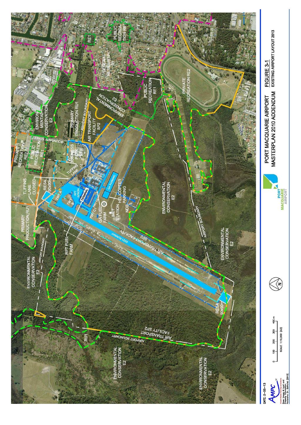
12 3.0 EXISTING AIRPORT INFRASTRUCTURE AND FACILITIES Figure 3-1 included in Appendix A shows the airport infrastructure and facilities that will be in place following completion of the Stage 1A airside infrastructure upgrade. The following table lists the key characteristics of runway 03/21 that will be published in the En Route Supplement Australia (ERSA) published by Airservices: Runway Ref. Code Dimensions (m) Strip Width (m) Surface Strength Runway 03/21 4C 1,800 x graded Asphalt (Flexible) - Grooved PCN30/F/C/1400 (203PSI)/T On completion of the upgrade, runway 03/21 will be suitable for regular daily operations of aircraft up to approximately 72.5 tonne maximum take-off weight (MTOW). The grass runway 10/28 was permanently decommissioned in December 2012 as part of the Stage 1A upgrade project. Figure 3-2 RPT Apron Layout (2013) Master Plan 2010 Addendum Report 6 December 2013
13 On completion of the upgrade, the RPT apron will provide four (4) free moving parking positions for RPT aircraft as shown in Figure 3-2 above. Bays 1 and 2 located immediately in front of the terminal building will be suitable for up to Code 4 aircraft (max. Embraer E190). Bays 3 and 4 will be suitable for up to Code 4 aircraft (max. B / A320). Bays 3 and 4 will be connected to runway 03/21 via a new taxiway connection (Taxiway Alpha). The Stage 1A apron will provide significant capacity for growth in air services and operational flexibility over the coming years. Figure 3-1 also shows the location of the relocated helicopter landing and parking area, and grassed general aviation (GA) aircraft parking area to the south of Taxiway Charlie. The relocated helicopter landing and parking area was commissioned at the end of April Master Plan 2010 Addendum Report 7 December 2013
 as shown in Figure 4-1 below, Port Macquarie Airport")
14 4.0 AVIATION DEMAND FORECASTS 4.1 RPT Passenger Movement Forecast Based on annual statistics prepared by the Bureau of Infrastructure, Transport and Regional Economics (BITRE) as shown in Figure 4-1 below, Port Macquarie Airport was the fifth largest regional airport in NSW in 2012 with 232,314 passenger movements. Figure 4-1 Annual Passenger Movements 2012 Source: BITRE BITRE has predicted that passenger movements through Australian airports will increase by four per cent per annum over the next 20 years, resulting in a doubling of passenger movements over this period. As shown in Figure 4-2 below, adopting this growth rate, passenger movements at Port Macquarie Airport are forecast to reach around 450,000 passengers per annum by The proposed Stage 1A upgrade will provide the next major impetus to promote growth in passenger numbers, with the potential for 300,000 to 350,000 passengers per annum by Master Plan 2010 Addendum Report 8 December 2013
15 Figure 4-2 RPT Passenger Movement Forecast 4.2 RPT Aircraft Movement Forecast see Master Plan GA Aircraft Movement Forecast see Master Plan 2010 Master Plan 2010 Addendum Report 9 December 2013
16 5.0 DEVELOPMENT CONSTRAINTS The Master Plan 2010 identified various environmental constraints on or adjacent to the Airport site that require careful consideration as part of the planning for the future operation and development of the Airport. With regard to the requirement for a 300 metre wide runway strip and approach surface length of inner edge, preliminary investigations have identified the following key constraints: the location of existing vegetation along both sides of the runway strip and infringing the associated 1:7 transitional surface and 2% approach surfaces at each end of runway 03/21; and the location of existing infrastructure including the RPT apron, terminal building and car park. As the existing vegetation surrounding the Airport includes areas identified as coastal wetlands protected under State Environmental Planning Policy (SEPP) 14, and potentially containing endangered ecological communities and / or threatened fauna species including core koala habitat, the requirement to clear and crop this vegetation to comply with the full Code 4C aerodrome standard will be subject to detailed environmental assessment in accordance with the Environmental Planning and Assessment Act 1979 and the Environmental Planning and Assessment Regulations With regard to the location of the existing RPT apron, terminal building and car park infrastructure, which were originally established based on the Code 3C aerodrome standard and a 150 metre wide runway strip, CASA has advised that future development in this area should not encroach into the 300 metre runway strip or infringe the associated transitional surface. While the existing infrastructure remains in its current location, Port Macquarie Airport will only be able to achieve a 150 metre runway strip in this area - this infrastructure would need to be relocated to comply fully with the 300 metre Code 4C standard. As identified in the Master Plan 2010, one of the priority objectives for Council is to promote further employment and economic development opportunities through the development of an Airport Precinct business park (see Section 10). The area identified for this development is also subject to potential environmental constraints, and it is proposed to develop an overall Environmental Strategy for the Airport encompassing all aspects of future development to ensure that appropriate consideration, including mitigation and offsetting strategies, is given to the various environmental issues. Master Plan 2010 Addendum Report 10 December 2013
17 6.0 AIRCRAFT MOVEMENT AREAS 6.1 Runway 03/21 As previously discussed, on completion of the current Stage 1A airside infrastructure upgrade, runway 03/21 will be declared as a Code 4C runway 1,800 metres long x 45 metres wide (currently Code 3C 1,600 metres x 30 metres). The upgraded runway will be suitable for operations up to Code 4C (B / A320) aircraft as operated by the main domestic airlines, and will provide significant capacity for growth in air services over the coming years. There are no further upgrades proposed to runway 03/21 as part of this Addendum Report, other than investigation into the feasibility of widening the runway strip and approach surface from the existing Code 3C 150 metre width to the full Code 4C 300 metre standard. 6.2 Runway 10/28 The east-west grass runway 10/28 used by light GA aircraft was permanently decommissioned in December 2012 in conjunction with the Stage 1A upgrade to make way for other airport facilities, including the relocated helicopter landing and parking area, GA aircraft parking area, and the potential for future airport development as outlined in the Master Plan 2010 and this Addendum Report. 6.3 Taxiways A new taxiway connection, Taxiway Alpha, will be provided between the Runway 21 threshold and the expanded RPT apron (Bays 3 and 4) as part of the current Stage 1A upgrade. This will necessitate renaming of parts of the existing taxiway system. The Master Plan 2010 provided for a future full length Code C taxiway parallel to (and to the east of) runway 03/21. Based on ICAO guidelines, this taxiway (Taxiway Foxtrot) may not be required until aircraft movements reach around 50,000 to 60,000 movements per annum (currently 30,000). The timing for provision of this infrastructure will be subject to demand (runway occupancy and circuit / airspace capacity) and the availability of funding, with further consideration to be given to the potential for a staged provision of this infrastructure. The location of the parallel taxiway is impacted by the potential future requirement for a 300 metre wide runway strip, with the corresponding minimum separation distance between the Code 4C runway and parallel taxiway centrelines being 168 metres for a 300 metre wide runway strip (previously identified as being 101 metres). This alignment conflicts with the location of: the existing terminal building and car park towards the northern end of the Airport site; the existing Bureau of Meteorology weather station; and the existing Airport property boundary at the southern end of the Airport site. Consultation will be required with the Bureau of Meteorology to determine the feasibility of relocating the existing weather station facility. Subject to further planning consideration, the constraints at each Master Plan 2010 Addendum Report 11 December 2013
18 end of the Airport site may limit the length of the parallel taxiway ultimately able to be provided in the future. A 36 metre clearance has been allowed for, from the centreline of the parallel taxiway to the east to the new fence (boundary) line to allow for the required taxiway strip width, perimeter access road and security clearances. The location of the parallel taxiway and taxiway strip extends into land zoned as E2 Environmental Conservation under the Port Macquarie-Hastings Local Environmental Plan Clearing of existing vegetation in this area will be subject to further detailed environmental assessment and planning approval. The existing Taxiway Charlie leading to the general aviation precinct is currently operated as a Code B taxiway with a 20 metre wingspan limit and corresponding 39 metre wide taxiway strip. This Addendum Report has made provision to reserve a 52 metre wide taxiway strip from the boundary of the existing general aviation hangar sites (GA1 and GA2), to allow for future upgrading of this taxiway to Code C standard should this be required to support further aviation related development in the future. 6.4 RPT Apron As previously discussed, on completion of the current Stage 1A airside infrastructure upgrade, the RPT apron will provide four (4) free moving parking positions for RPT aircraft, with Bays 1 and 2 located immediately in front of the terminal building being suitable for up to Code 4 aircraft (max. Embraer E190), and Bays 3 and 4 being suitable for up to Code 4 aircraft (max. B / A320). The Stage 1A apron will provide significant capacity for growth in air services and operational flexibility over the coming years. As identified in the Master Plan 2010, further consideration may need to be given to the provision of a covered passenger walkway to Bays 3 and 4 to protect passengers during periods of inclement weather. Tuffins Lane, to the north of the RPT apron, is due to be closed as part of the Stage 1A upgrade to comply with CASA and Office of Transport Security safety and security requirements associated with the operation of aircraft on the expanded apron. The apron layout, including flood lighting arrangement, is consistent with the existing Code 3C 150 metre wide runway strip and its associated 1:7 transitional (obstacle limitation) surface. To comply with the full Code 4C 300 metre wide runway strip standard (and associated transitional surface) in the future, this Addendum Report has identified two potential options to either expand the existing apron further to the east of its current location (Figure 13-1 Option 1), or to relocate the apron to a new greenfield site south of Taxiway Charlie (Figure 13-2 Option 2). The expansion of the apron at Option 1 potentially impacts on Oliver Drive and the existing GA1 apron and hangar area. Option 2, whilst providing a more ideal location from a master planning perspective, being located approximately midway along the runway minimising taxiing time for arriving and departing aircraft, also requires the provision of a new terminal building and associated facilities (including car parking, access roads, services etc) and as such is likely to be subject to funding constraints. Master Plan 2010 Addendum Report 12 December 2013
19 Recognising the significant cost implication of relocating the RPT apron (and potentially also the terminal building and associated facilities), an alternative or interim option to relocating this infrastructure may be available, whereby the existing 150 metre wide runway strip is retained on the eastern side of runway 03/21 north of Taxiway Charlie (approximately 300 metres from the RWY 21 threshold) - this option would be subject to further consultation with CASA and airlines consistent with the provisions of Civil Aviation Regulation CAR 235A. 6.5 GA Facilities Council s strategy remains, as set out in the Master Plan 2010, to cater for increasing demand for general aviation facilities in partnership with Taree and Kempsey Airports as part of the Mid North Coast Regional Aviation Plan. Council acknowledges the importance of retaining a vibrant and sustainable general aviation presence at Port Macquarie Airport and will continue to support aviation related business activities that have the potential to provide significant employment and economic benefits to the Port Macquarie Hastings region. This Addendum Report identifies an area south of Taxiway Charlie (opposite the existing GA2 apron area) as a possible site for general aviation related business activities subject to further consultation. It should be noted that the development option identified in the Master Plan 2010 (west of runway 03/21) has since been determined to be not feasible due to a range of environmental and infrastructure constraints. Figure 13-1 (Option 1) presented in this Report identifies that the area currently occupied by the GA1 apron and hangar sites may need to be reserved for future expansion of the RPT facilities (terminal building and car parking) subject to growth in air services and passenger numbers. As such, Council s current policy of limiting lease renewals in this area to short terms (max. 5 years) will continue, to provide Council with flexibility for redevelopment of this area should that be required in the future. Figure 13-2 (Option 2) shows no such impact on the GA1 apron area. On completion of the current Stage 1A airside infrastructure upgrade, an area south of Taxiway Charlie as shown in Figure 3-1 included in Appendix A will be made available as a grassed parking area for local and itinerant GA aircraft. 6.6 Helicopter Facilities As part of the current Stage 1A upgrade, the helicopter landing and parking area, previously located north of the RPT apron, has been relocated to an area south of Taxiway Charlie as shown in Figure 3-1 included in Appendix A. This new facility was commissioned at the end of April Should the master plan Option 2 be adopted as the future development scenario, an alternative location for the helicopter landing and parking area will need to be determined as part of the detailed planning and design for that development scenario. Master Plan 2010 Addendum Report 13 December 2013
20 7.0 AVIATION SUPPORT FACILITIES 7.1 Refuelling Facilities The existing RPT fuel farm (operated by Air BP) located adjacent to Taxiway Foxtrot 2 (previously Bravo) and the western end of the terminal building is due to be relocated to Air BP s general aviation refuelling site as part of Air BP s current development plans. This will relocate the RPT fuel facility outside of the potential future 300 metre wide runway strip. The existing general aviation fuel farms (Air BP and Aero Refuellers) are located north of Taxiway Charlie adjacent to the GA1 apron area. As previously discussed, Figure 13-1 (Option 1) has identified the need to reserve this area for potential future expansion of the RPT facilities associated with this option, and as such, and in consideration of Air BP s current development plans, consideration needs to be given to identifying the most appropriate long-term location for these aircraft refuelling facilities. Figure 13-1 (Option 1) and Figure 13-2 (Option 2) included in Appendix A show a potential site south of Taxiway Charlie for the relocation of the refuelling facilities subject to further consultation. 7.2 Ground Support Equipment Storage Areas An additional storage area for airline ground support equipment (GSE) is being provided adjacent to Bay 3 as part of the current Stage 1A airside upgrade. Growth in air services and the introduction of potential new aircraft will continue to require operational assessment and identification of areas suitable for the storage of airline ground support equipment. 7.3 Navigation and Approach Aids This Addendum Report identifies the potential requirement for the relocation of the existing nondirectional beacon (NDB) to make way for future aviation related development east of runway 03/21. Figure 13-1 (Option 1) and Figure 13-2 (Option 2) included in Appendix A identify an area west of runway 03/21 as a possible future location for the NDB subject to consultation with Airservices. 7.4 Weather Information Service As previously discussed, this Addendum Report identifies the potential requirement for the relocation of the existing Bureau of Meteorology weather station (AWIS) to make way for future aviation related development east of runway 03/21 including the future parallel taxiway. Figure 13-1 (Option 1) and Figure 13-2 (Option 2) included in Appendix A identify an area west of runway 03/21 as a possible future location for the weather station subject to consultation with the Bureau of Meteorology. 7.5 Aerodrome Rescue and Fire-Fighting Services As set out in the Master Plan 2010, Aerodrome Rescue and Fire-Fighting Services (ARFFS) are required to be established (by Airservices) when annual passenger numbers exceed 350,000 passengers per annum. Based on the forecast passenger growth outlined in Section 4.1, ARFFS facilities may be required within the next 10 years. Figure 13-1 (Option 1) and Figure 13-2 (Option 2) Master Plan 2010 Addendum Report 14 December 2013
21 included in Appendix A identify an area east of runway 03/21 as a possible location for a future ARFFS facility. 7.6 Air Traffic Control As identified in the Master Plan 2010, there are currently no air traffic control (ATC) facilities located at Port Macquarie Airport (a non-towered aerodrome). The Australian Government Department of Infrastructure and Transport published new guidelines for the provision of ATC facilities in June 2012 in its Australian Airspace Policy Statement. This document identified the following airspace criteria thresholds (for ATC and Class D airspace) to assist in determining when changes to airspace classification may be required: 80,000 total annual aircraft movements; 15,000 total annual RPT aircraft movements; or 350,000 total annual RPT passengers. Whilst the forecasts for aircraft movements at Port Macquarie Airport fall well short of the corresponding thresholds shown above, the passenger threshold is consistent with that set for ARFFS facilities, and as such, subject to an airspace review by CASA (Office of Airspace Regulation) at that time, ATC facilities may be required within a similar timeframe (ie next 10 years) as identified for ARFFS services. Figure 13-1 (Option 1) and Figure 13-2 (Option 2) included in Appendix A identify an area east of runway 03/21 as a possible location for a future ATC facility (co-located with a future ARFFS facility). Master Plan 2010 Addendum Report 15 December 2013
22 8.0 PASSENGER FACILITIES 8.1 Passenger Terminal The existing passenger terminal building was originally established based on the Code 3C aerodrome standard for a 150 metre wide runway strip and associated transitional surface. Whilst the terminal building is located outside the area of the potential future Code 4C 300 metre wide runway strip, part of the existing building infringes the associated 1:7 transitional (obstacle limitation) surface. CASA does not require that part of the existing terminal building to be removed, but has advised that future development in this area should not encroach into the 300 metre runway strip or infringe the associated transitional surface. New guidelines have also being published since the Master Plan 2010 was adopted, with regard to the location of buildings adjacent to runways. The National Airports Safeguarding Framework published by the Australian Government Department of Infrastructure and Transport in May 2012, sets out factors for consideration with regard to the possible effects on aircraft operations of building generated windshear and turbulence in strong cross wind conditions. In considering future development options, further assessment of the existing terminal building may be required due to its proximity to runway 03/21. Figure 13-1 (Option 1) and Figure 13-2 (Option 2) included in Appendix A identify various options for the future development of the passenger terminal facilities to achieve compliance with the Code 4C aerodrome standards and advice provided by CASA. These options include: staged development / redevelopment of the existing terminal building generally to the east of the existing building and / or clear of the transitional surface associated with the 300 metre runway strip (Option 1 - short to medium term); new terminal development to the east of the existing / expanded RPT apron (Option 1 - long term); or new terminal development in new greenfield site south of Taxiway Charlie (Option 2 - long term). The new terminal options ultimately allow for compliance to be achieved with the full Code 4C aerodrome standards. The location of the terminal building in these options (that is, the set back from the runway centreline) has been determined on the basis of the associated RPT apron and critical planning height allowed for the required apron flood lighting poles (25 metres) - to avoid the 1:7 transitional (obstacle limitation) surface, the apron / terminal interface has been set at a distance of 325 metres from the runway centreline. The final location will be subject to detailed design. Due to funding constraints and the requirement for associated infrastructure, the new terminal options are considered potential long-term future development scenarios. Master Plan 2010 Addendum Report 16 December 2013
23 Given that the Master Plan 2010 identified that the existing terminal building operates at near capacity during current busy hour peak periods, further growth in air services and passengers numbers in the short term will dictate the need for further consideration to be given to options for the incremental, staged development of the existing terminal building to cater for demand. On completion of the current Stage 1A airside upgrade, it is recommended that further consideration be given to the options and funding available for a cost effective upgrade of the existing passenger terminal facilities as part of the previously proposed Stage 1B landside upgrade which was deferred by Council in July 2012 pending further consultation with CASA and a review of the Master Plan Car Parking Facilities As with the terminal building, the existing car parking area was originally established based on the Code 3C aerodrome requirement for a 150 metre wide runway strip and associated transitional surface. The western edge of the existing car park encroaches into the area required for the potential future Code 4C 300 metre runway strip. On the basis of the advice provided by CASA, that future development in this area should not encroach into the 300 metre runway strip or infringe the associated transitional surface, further consideration will need to be given to plans to upgrade the existing car park. The Master Plan 2010 identified that the existing car park is operating at capacity during current peak periods. In lieu of the previously proposed Stage 1B car park upgrade, Council is progressing with plans to provide a new 110 space standalone rental and staff car park to the east of the RPT apron off Tuffins Lane, to free up capacity in the main public car park located in front of the existing terminal building. Development approval has been granted for this facility, with detailed design currently underway. The new car park is expected to be completed by the end of 2013, increasing car park capacity at the Airport from the existing 175 spaces to 285 spaces. With the relocation of the existing GA aircraft parking area adjacent to Taxiway Charlie as part of the current Stage 1A airside upgrade, the area south of the existing car park will become available for a possible future expansion of the existing car park, with space for at least 100 additional parking spaces subject to detailed design. This expansion, together with the planned rental and staff car park, has the potential to provide significant capacity in the short term (up to approximately 400 car parking spaces) to cater for forecast growth in air services and passenger numbers. Figure 13-1 (Option 1) and Figure 13-2 (Option 2) included in Appendix A identify options for future development of the car parking facilities to meet demand and achieve compliance with the Code 4C aerodrome standards. Subject to growth in air services and passenger numbers, Option 1 identifies the possible future expansion of car parking into the area currently occupied by the GA1 apron and hangar sites. Option 2 shows no such impact on the GA1 apron area. Master Plan 2010 Addendum Report 17 December 2013
24 9.0 GROUND TRANSPORT SYSTEM 9.1 Access Roads The Master Plan 2010 identified the following key points in relation to the road network adjacent to the Airport: closure of Tuffins Lane as part of the upgrade of runway 03/21 and provision of the northern runway end safety area (RESA); improvements to the Hastings River Drive - Boundary Street intersection; flooding of Boundary Street and the requirement for flood-free access to the Airport; and the future Outer Link Road proposed as part of the strategic regional road network. A section of Tuffins Lane to the north of the runway and expanded RPT apron was closed at the end of August as part of the current Stage 1A airside upgrade. The closure is required to meet the safety and security requirements of CASA and the Office of Transport Security. Following closure, access to the Airport will not be available from Tuffins Lane, with access only being available from Boundary Street. Council is currently working on the planning and design for a proposed upgrade of the Hastings River Drive - Boundary Street intersection (to traffic signals) to improve the operation of this key intersection. These improvement works are planned to be undertaken in Flooding of Boundary Street in February 2013 highlights the need for improved flood-free road access to the Airport and surrounding area. Planning for improvements to Boundary Street is to be considered in conjunction with planning for an Outer Link Road (North - South link) linking the Oxley Highway and Hastings River Drive as part of Council s strategic regional road network. It is recommended that as part of the planning for a future Outer Link Road, Council give consideration to the future road access requirements to the Airport noting Figure 13-1 (Option 1) and Figure 13-2 (Option 2) included in Appendix A showing the potential future development scenarios for the Airport. Master Plan 2010 Addendum Report 18 December 2013
25 10.0 DEVELOPMENT PRECINCTS The Master Plan 2010 identified various precincts for future development at the Airport. This Addendum Report has rationalised those areas consistent with Council s priority objectives identified in Section 2, to define: areas required for future aviation uses, that being areas required for the future operation and development of the Airport consistent with the aviation demand forecasts provided in Section 4 and the requirement to comply with the full Code 4C aerodrome standards including the 300 metre wide runway strip and associated transitional surface; and areas available for non-aviation uses, including commercial property development as part of the proposed Airport Precinct business park. Figure 10-1 included in Appendix A identifies the above areas, with the aviation / non-aviation boundary being located approximately 600 metres to the east of the centreline of runway 03/21, east of the existing general aviation precinct. Approximately 28 hectares of land to the east of this line has been identified as being available for the proposed Airport Precinct business park subject to further environmental investigation and rezoning. Figure 10-1 also identifies an area of Council-owned land within the Airport site, adjacent to The Binnacle residential area, which is zoned as R1 General Residential under the Port Macquarie- Hastings Local Environmental Plan Subject to further environmental assessment, this area has been identified as a potential site for a future Airport related accommodation / hotel development UTILITIES see Master Plan 2010 Master Plan 2010 Addendum Report 19 December 2013
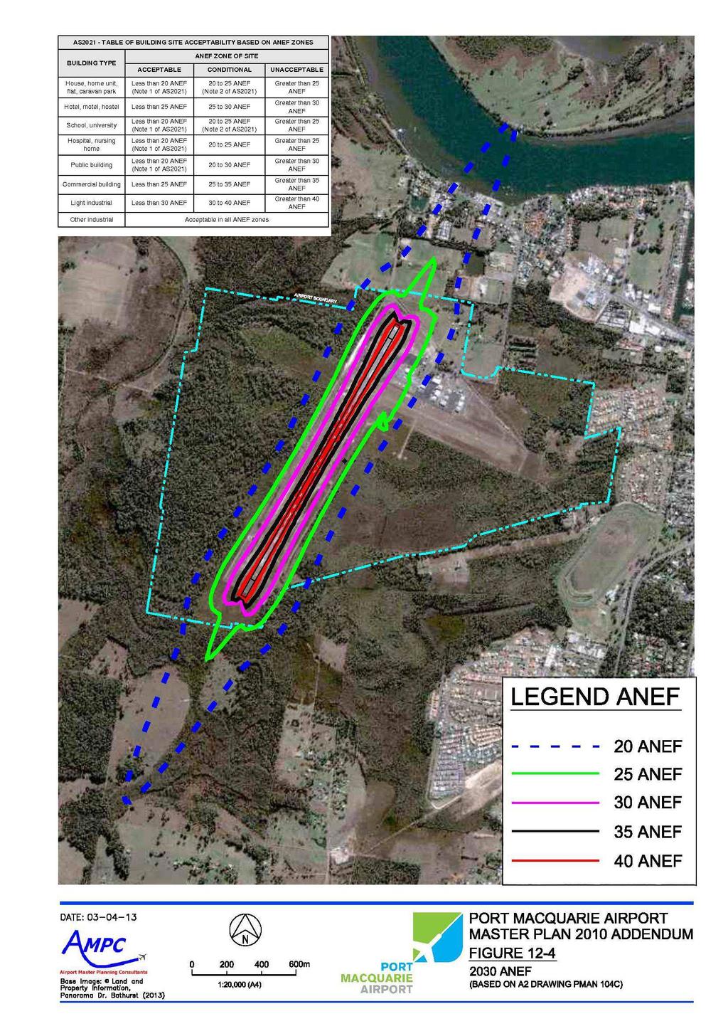
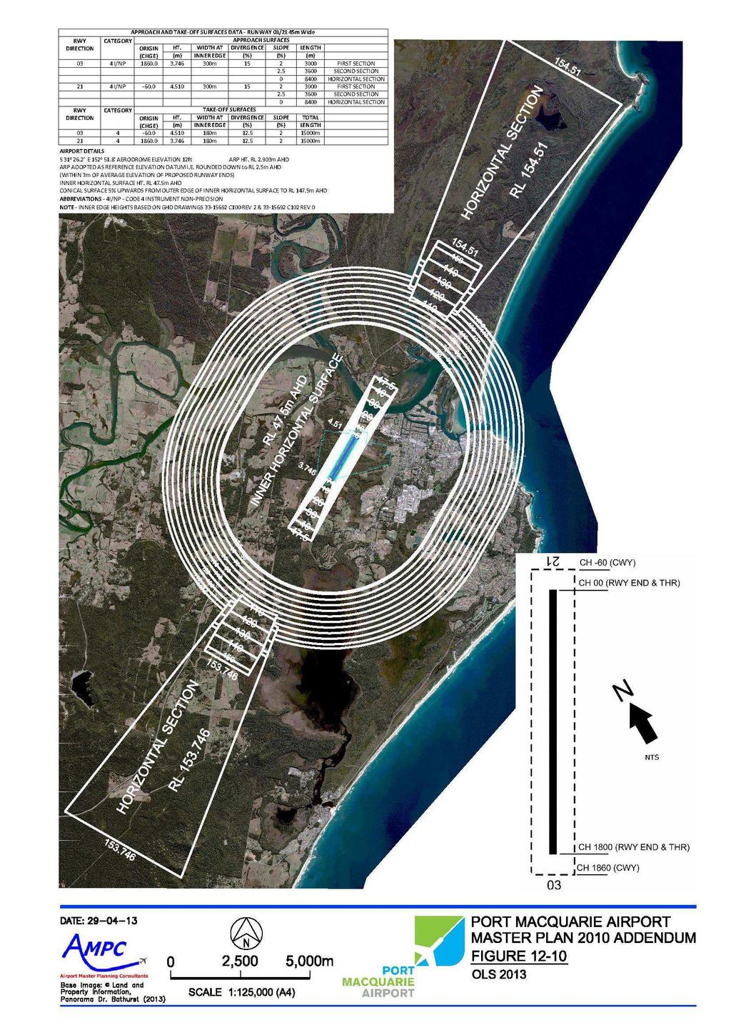
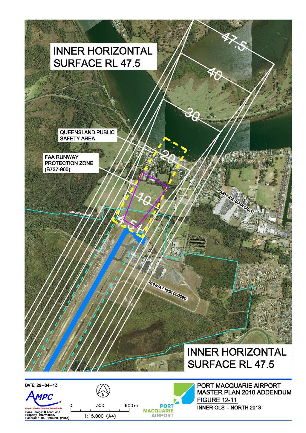
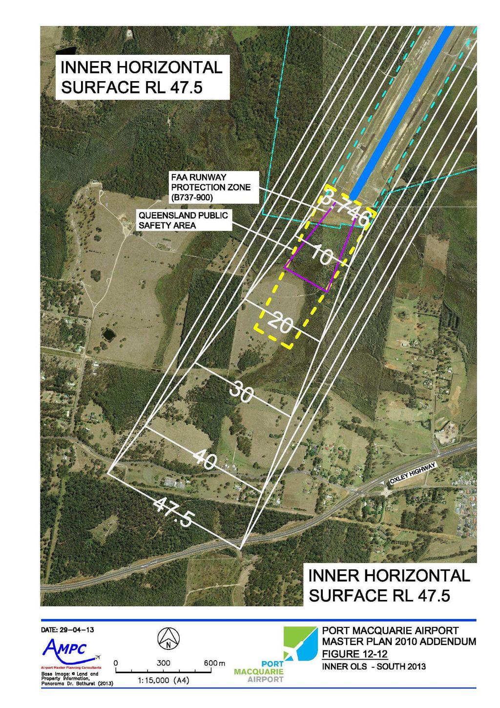
26 12.0 ENVIRONMENTAL AND LAND USE PLANNING IMPACTS 12.1 Aircraft Noise Figure 12-1 and Figure 12-4 included in Appendix A show the 2009 Australian Noise Exposure Index (2009 ANEI) and 2030 Australian Noise Exposure Forecasts (2030 ANEF) charts for Port Macquarie Airport as formally endorsed by Airservices in These charts, as described in Australian Standard AS provide a measure of the aircraft noise exposure levels in the vicinity of the Airport and are provided for information purposes for the local community and for use by Council in its land use planning and development control functions. The charts provided in Appendix A indicate: Figure 12-1: 2009 ANEI the estimated current level of aircraft noise exposure based on actual aircraft movements recorded in the 2009 calendar year; and Figure 12-4: 2030 ANEF the estimated future level of aircraft noise exposure based on forecast aircraft movements in 2030 (as described in Section 4) 12.2 Obstacle Limitation Surfaces Figure 12-10, Figure and Figure included in Appendix A show the updated obstacle limitation surfaces (OLS) around the Airport consistent with the current Stage 1A airside upgrade and advice provided by CASA with regard to the future Code 4C aerodrome requirement for a 300 metre wide runway strip and approach surface length of inner edge. These charts should be adopted by Council for future land use planning and development control purposes so as to safeguard the future operation of the Airport and prevent inappropriate development in the vicinity of the Airport which could result in unnecessary constraints on airport operations. As discussed previously in this Addendum Report, due to a range of environmental constraints and the location of existing infrastructure (including the RPT apron, terminal building and car park) widening of the runway strip and approach surface to 300 metres will be subject to further detailed environmental investigations and the development of future infrastructure clear of the associated transitional surface Flooding and Stormwater Drainage see Master Plan Other Development Control Considerations As identified in Section 1, since the Master Plan 2010 was adopted, the Australian Government Department of Infrastructure and Transport has identified a number of emerging planning considerations in its National Airports Safeguarding Framework and Safeguarding Airports and the Communities Around Them Discussion Paper. These documents identify a potential future requirement for the provision of public safety zones (PSZs) at each end of runway 03/21. Whilst there Master Plan 2010 Addendum Report 20 December 2013
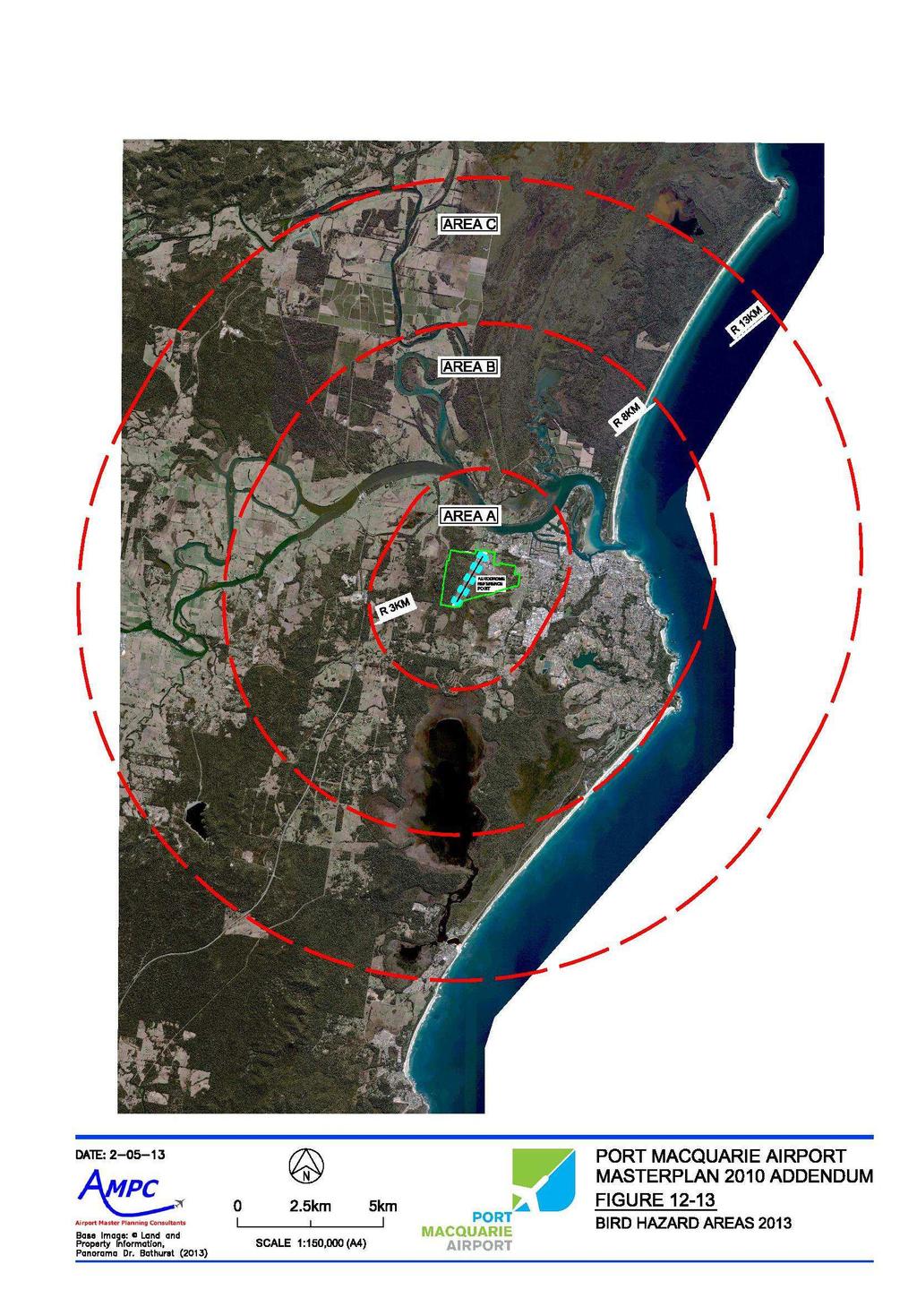
27 is currently no national standard in place for these areas, Figure and Figure included in Appendix A show indicative PSZ areas based on United States and Queensland standards for information purposes only. It is recommended that Council give further consideration to this emerging issue in conjunction with its land use planning and development control functions. Figure included in Appendix A also provides updated guidance to Council as to appropriate land uses in the vicinity of the Airport so as to minimise the risk of bird hazards to aircraft operations. Figure should be read in conjunction with the guidelines published in the National Airports Safeguarding Framework. Master Plan 2010 Addendum Report 21 December 2013
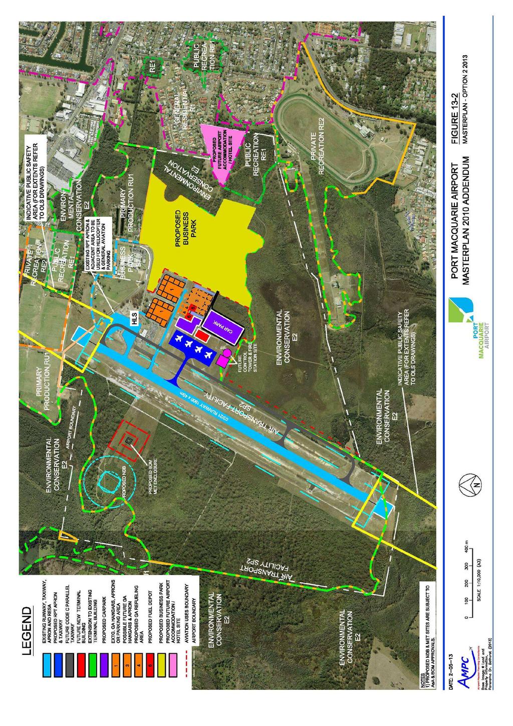
28 13.0 MASTER PLAN 2013 Figure 13-1 (Option 1) and Figure 13-2 (Option 2) included in Appendix A identify options for the future development of the Airport to meet the forecast growth in RPT air services and passengers numbers to 2030, and comply with CASA s full Code 4C aerodrome standards. Both options also identify potential areas for general aviation related business activities to meet demand, and areas for future commercial property development as part of the proposed Airport Precinct business park. The key features of the two options include: 13.1 Option 1 the Stage 1A airside upgrade of runway 03/21 to Code 4C standard, 1,800 metres long x 45 metres wide, including closure of Tuffins Lane - initial operations of Code 4C aircraft in accordance with CASA exemption with respect to the existing Code 3C 150 metre wide runway strip and approach surface; future widening of the existing Code 3C 150 metre wide runway strip and approach surface to 300 metres in accordance with the full Code 4C aerodrome standard - subject to detailed environmental investigation and planning approval; staged construction of a new Code C taxiway (Taxiway Foxtrot) parallel to and 168 metres to the east of runway 03/21 - subject to detailed environmental investigation and planning approval; timing / staging also subject to demand (runway occupancy and circuit / airspace capacity) and the availability of funding; reserving of a 52 metre wide Code C taxiway strip at Taxiway Charlie to allow for future upgrading of the taxiway to Code C standard should this be required to support further aviation related development in the future; future expansion of the existing RPT apron to the east to comply with the full Code 4C aerodrome standards, with four (4) free moving parking positions for up to Code 4C aircraft; either, staged development / redevelopment of the existing terminal building generally to the east of the existing building and / or clear of the transitional surface associated with the 300 metre runway strip, or provision of a new terminal building to the east of the expanded RPT apron, in accordance with the full Code 4C aerodrome standard; expansion of the existing car parking facilities to meet demand - noting the potential impact on the existing GA1 apron and hangar area; possible future relocation of the general aviation facilities to an area south of Taxiway Charlie to support aviation related business activities; Master Plan 2010 Addendum Report 22 December 2013
29 possible future relocation of aircraft refuelling facilities to an area south of Taxiway Charlie subject to further consultation; relocation of the existing non-directional beacon (NDB) to an area west of runway 03/21, to make way for future aviation related development - subject to consultation with Airservices; relocation of the existing Bureau of Meteorology weather station (AWIS) to an area west of runway 03/21, to make way for future aviation related development including the future parallel taxiway - subject to consultation with the Bureau of Meteorology; possible future provision of Aerodrome Rescue and Fire-Fighting Services (ARFFS), and Air Traffic Control (ATC) facilities subject to growth in air services / passenger numbers; identification of land not required for future aviation uses, to be made available for commercial property development as part of the proposed Airport Precinct business park; identification of land zoned R1 General Residential adjacent to The Binnacle residential area for possible future Airport related accommodation / hotel development; and principal road access subject to further planning for an Outer Link Road (North - South link) linking the Oxley Highway and Hastings River Drive. Option 1 has the potential to support incremental staged development of the existing infrastructure to meet demand in air services commensurate with the availability of funding, and as such is considered suitable for development in the short to medium term Option 2 the Stage 1A airside upgrade of runway 03/21 to Code 4C standard, 1,800 metres long x 45 metres wide, including closure of Tuffins Lane - initial operations of Code 4C aircraft in accordance with CASA exemption with respect to the existing Code 3C 150 metre wide runway strip and approach surface; future widening of the existing Code 3C 150 metre wide runway strip and approach surface to 300 metres in accordance with the full Code 4C aerodrome standard - subject to detailed environmental investigation and planning approval; staged construction of a new Code C taxiway (Taxiway Foxtrot) parallel to and 168 metres to the east of runway 03/21 - subject to detailed environmental investigation and planning approval; timing / staging also subject to demand (runway occupancy and circuit / airspace capacity) and the availability of funding; reserving of a 52 metre wide Code C taxiway strip at Taxiway Charlie to allow for future upgrading of the taxiway to Code C standard should this be required to support further aviation related development in the future; Master Plan 2010 Addendum Report 23 December 2013
30 provision of a new RPT apron south of Taxiway Charlie in accordance with the full Code 4C aerodrome standards, with four (4) free moving parking positions for up to Code 4C aircraft; provision of a new terminal building south of Taxiway Charlie in accordance with the full Code 4C aerodrome standard; provision of new car parking facilities south of Taxiway Charlie; relocation of existing helicopter landing and parking area, and general aviation aircraft parking areas subject to further detailed planning; possible future general aviation facilities in an area south of Taxiway Charlie to support aviation related business activities; possible future relocation of aircraft refuelling facilities to an area south of Taxiway Charlie subject to further consultation; relocation of the existing non-directional beacon (NDB) to an area west of runway 03/21, to make way for future aviation related development - subject to consultation with Airservices; relocation of the existing Bureau of Meteorology weather station (AWIS) to an area west of runway 03/21, to make way for future aviation related development including the future parallel taxiway - subject to consultation with the Bureau of Meteorology; possible future provision of Aerodrome Rescue and Fire-Fighting Services (ARFFS), and Air Traffic Control (ATC) facilities subject to growth in air services / passenger numbers; identification of land not required for future aviation uses, to be made available for commercial property development as part of the proposed Airport Precinct business park; identification of land zoned R1 General Residential adjacent to The Binnacle residential area for possible future Airport related accommodation / hotel development; and principal road access subject to further planning for an Outer Link Road (North - South link) linking the Oxley Highway and Hastings River Drive. Whilst Option 2 offers some operational benefits through the reduced impact on existing airport infrastructure / facilities and locating the RPT apron / terminal building in a more ideal location from a master planning perspective, this development option is likely to require a significant one-off capital investment to provide the new infrastructure required (incl. RPT apron, terminal building, car parking, access roads, services etc). As such Option 2 is considered a potential long-term development scenario subject to the availability of funding. Master Plan 2010 Addendum Report 24 December 2013
31 14.0 STAGING CONSIDERATIONS AND FUNDING OPTIONS As highlighted in this Addendum Report, significant works will be required to upgrade the airport infrastructure and facilities to ultimately comply with the full Code 4C aerodrome standards. Much of this work will also be subject to detailed environmental investigation and planning approval. It is recommended that Council continue to liaise closely with CASA and airline operators through this period of significant regulatory reform to identify any potential operating constraints and commercial risks to Council, as the aerodrome operator, through continuing to operate the Airport in the short to medium term, as a Code 3C aerodrome (irrespective of the upgraded 45 metre wide Code 4C runway) - noting that CASA has confirmed that Code 4C aircraft will be permitted to operate at Port Macquarie Airport following the current Stage 1A airside upgrade either through achieving compliance with the full Code 4C aerodrome standards or under the provisions of Civil Aviation Regulation CAR235A. Notwithstanding the above, Council has stated its long term planning objective as set out in this Addendum Report to seek to comply with the full Code 4C aerodrome standards wherever possible to future proof the ongoing operation and development of Port Macquarie Airport for Code 4C aircraft. This program of work will be staged as necessary to suit: compliance with mandatory CASA standards (and other relevant legislation) commensurate with the level and type of aircraft operations at the time; demand brought about through forecast growth in RPT air services and passenger numbers; demand brought about through growth in general aviation (GA) related business activities; demand for commercial property development as part of the proposed Airport Precinct business park; and the availability of funding for major capital projects (noting that the investment decision for major projects will continue to be subject to the approval of a detailed and robust business case, consistent with the requirements of the Division of Local Government Capital Expenditure Review guidelines). It should be noted that following completion of the current Stage 1A airside infrastructure upgrade, the Airport s borrowing capacity will be constrained in the short to medium term. This Addendum Report recommends the following short-term (0 to 5 years) priority actions: completion of the current Stage 1A airside upgrade including runway 03/21, taxiways and RPT apron to cater for initial operations of Code 4C (B / A320 aircraft); completion of environmental investigations to determine the feasibility of widening the runway strip and approach surface to comply with the full Code 4C aerodrome standard - this work to include detailed environmental assessment of the clearing and cropping of existing vegetation required, and submission of a development application to obtain planning approval from relevant Master Plan 2010 Addendum Report 25 December 2013
32 Consent Authorities (including the NSW Department of Planning, NSW Office of Environment and Heritage, and Council) Note: progressing these investigations is a condition of the initial 3-year exemption to be issued by CASA on completion of the current Stage 1A upgrade; completion of the proposed 110 space rental and staff car park to relieve current capacity constraints in the main public car park - due to be completed by the end of 2013; further consideration to be given to the options and funding available for a cost effective upgrade of the existing passenger terminal and car parking facilities as part of the deferred Stage 1B landside upgrade, to cater for demand brought about through forecast growth in RPT air services and passenger numbers - subject to the availability of funding and ongoing consultation with CASA; further consideration to be given to the opportunities / demand for other aviation related business activities and the identification of corresponding infrastructure requirements - subject to the availability of funding and approval of a detailed business case; consultation with Airservices and Bureau of Meteorology regarding the potential future relocation of the existing NDB and weather station respectively; ongoing consultation with CASA and airlines as to the future operating standards / requirements for Code 4C aircraft at Port Macquarie Airport; and completion of environmental and land use planning investigations to determine the feasibility of the proposed Airport Precinct business park (Airport lands) and submission of a development application to obtain planning approval from relevant Consent Authorities (including the NSW Department of Planning, NSW Office of Environment and Heritage, and Council). Master Plan 2010 Addendum Report 26 December 2013
33 APPENDIX A Master Plan 2010 Addendum Report 27 December 2013
34
35
36
37
38
39
40
41
42
43
Sunshine Coast Airport Master Plan September 2007
 Sunshine Coast Airport Master Plan September 2007 Contents CONTENTS... I ACKNOWLEDGEMENT... II DISCLAIMER... III 1 EXECUTIVE SUMMARY...IV 1 INTRODUCTION... 1 2 AVIATION DEMAND FORECAST... 5 3 AIRCRAFT
CHAPTER 9 RUNWAYS AND AIRFIELD DEVELOPMENTS
 CHAPTER 9 RUNWAYS AND AIRFIELD DEVELOPMENTS CANBERRA AIRPORT IS THE ONLY 24 HOUR BOEING 747, B777-300 AND A340 CAPABLE AIRPORT...BETWEEN BRISBANE AND MELBOURNE. 9 Runway and airfield developments Airports
AERODROME LICENCE APPLICATION PROCESS
 0000180111 Page 2 Why is a Licence Required? An aerodrome licence is required for a site if it is intended to facilitate operations by commercial transport aircraft, other aerial work other than rotorcraft,
A Master Plan is one of the most important documents that can be prepared by an Airport.
 The Master Plan A Master Plan is one of the most important documents that can be prepared by an Airport. A Master Plan is a visionary and a strategic document detailing planning initiatives for the Airport
Aviation Development
 Aviation Development Gold Coast Airport has efficient and cost effective passenger processing and aircraft turn-around times that is underpinned by a strong focus on safety. 6.1 INTRODUCTION This focus
The implementation of this Master Plan will be undertaken in logical stages to meet passenger and workforce demands.
 The implementation of this Master Plan will be undertaken in logical stages to meet passenger and workforce demands. Connecting People Building Opportunities 198 Brisbane Airport Corporation CHAPTER 10
8 Aviation Support. 8.1 Aerodrome Rescue and Fire Fighting Services. 8.2 Aircraft Refuelling. 8.3 Air Cargo
 8 Aviation Support 8.1 Aerodrome Rescue and Fire Fighting Services CASA mandates that a permanent Aerodrome Rescue and Fire Fighting Service (ARFFS) is established for domestic aerodromes when more than
REVIEW OF PERTH AIRPORT Noise Abatement Procedures
 REVIEW OF PERTH AIRPORT Noise Abatement Procedures Contents SUMMARY... 3 Summary of Review Findings... 3 BACKGROUND... 4 Noise Abatement Procedures... 4 Perth Airport Noise Abatement Procedures... 4 Noise
Whangarei Airport. Prepared by Carine Andries 10/20173
 Whangarei Airport Prepared by Carine Andries 10/20173 March 2010 TABLE OF CONTENTS 1 2 3 INTRODUCTION... 3 AIRPORT ROLE AND FUNCTION... 3 AIRPORT FEATURES AND CAPACITY... 3 3.1 3.2 3.3 3.4 3.5 3.5.1 3.5.2
1.0 Project Background Mission Statement and Goals Objectives of this Sustainable Master Plan
 TABLE OF CONTENTS CHAPTER 1 INTRODUCTION 10 Project Background 1-1 11 Mission Statement and Goals 1-1 12 Objectives of this Sustainable Master Plan 1-2 CHAPTER 2 INVENTORY 20 Airport Background 2-1 201
ENVIRONMENT ACTION PLAN
 ENVIRONMENT ACTION PLAN 2015 16 Airservices Australia 2015 This work is copyright. Apart from any use as permitted under the Copyright Act 1968, no part may be reproduced by any process without prior written
Addendum - Airport Development Alternatives (Chapter 6)
") Bowers Field Addendum - Airport Development Alternatives (Chapter 6) This addendum to the Airport Development Alternatives chapter includes the preferred airside development alternative and the preliminary
Bowers Field Addendum - Airport Development Alternatives (Chapter 6) This addendum to the Airport Development Alternatives chapter includes the preferred airside development alternative and the preliminary
MANAGING THE RISK TO AVIATION SAFETY OF WIND TURBINE INSTALLATIONS (WIND FARMS)/WIND MONITORING TOWERS.
/WIND MONITORING TOWERS.") NATIONAL AIRPORTS SAFEGUARDING FRAMEWORK GUIDELINE D MANAGING THE RISK TO AVIATION SAFETY OF WIND TURBINE INSTALLATIONS (WIND FARMS)/WIND MONITORING TOWERS. REVISION DATE VERSION NUMBER CHANGES MADE APPROVED
NATIONAL AIRPORTS SAFEGUARDING FRAMEWORK GUIDELINE D MANAGING THE RISK TO AVIATION SAFETY OF WIND TURBINE INSTALLATIONS (WIND FARMS)/WIND MONITORING TOWERS. REVISION DATE VERSION NUMBER CHANGES MADE APPROVED
Billy Bishop Toronto City Airport; Porter Airlines Proposal Review; Interim Results/Findings, Airbiz, 26 June 2013
 Billy Bishop Toronto City Airport - Outstanding Questions for Transport Canada EXECUTIVE SUMMARY Transport Action has reviewed the reports published by Airbiz and LPS Avia Consulting and found that they
East Midlands Airport 2018 Aerodrome Manual
 East Midlands Airport 2018 Aerodrome Manual Version 1.0 Not Valid after 31 st December 2018 Department Operations Document Owner Operations Director (Accountable Manager) Document Administrator Ops Development
ERIE INTERNATIONAL AIRPORT MASTER PLAN TABLE OF CONTENTS
 EXECUTIVE SUMMARY ERIE INTERNATIONAL AIRPORT MASTER PLAN TABLE OF CONTENTS PAGE NO. CHAPTER 1-INTRODUCTION... 1-1 1.01 General...1-1 1.02 Purpose and Scope of Study...1-1 1.03 The Planning Process...1-2
Procedures for Air Navigation Services Aerodromes (PANS-AGA) ICAO Doc. 9981
 ICAO Doc. 9981") Procedures for Air Navigation Services Aerodromes (PANS-AGA) ICAO Doc. 9981 Introduction The First Edition of Doc. 9981 was approved by the President of the Council on 20 October 2014 The document becomes
Procedures for Air Navigation Services Aerodromes (PANS-AGA) ICAO Doc. 9981 Introduction The First Edition of Doc. 9981 was approved by the President of the Council on 20 October 2014 The document becomes
It is essential that planning take full account of air safety and efficiency of operations.
 Airspace Protection Airspace Protection It is essential that planning take full account of air safety and efficiency of operations. 7.1 INTRODUCTION Obstacles near an airport, whether they are natural
Connecting People Building Opportunities BRISBANE AIRPORT 2014 MASTER PLAN
 Connecting People Building Opportunities BRISBANE AIRPORT 2014 MASTER PLAN MASTER PLAN 2014 PROPOSED AIRPORT DEVELOPMENT STRATEGY 2034 Important Notice This Master Plan has been prepared by Brisbane Airport
Appendix D Project Newsletters. Tacoma Narrows Airport. Master Plan Update
 Appendix D Project Newsletters Tacoma Narrows Airport Master Plan Update This appendix contains the newsletters distributed throughout the project. These newsletters provided updates and information on
Table of Contents. Overview Objectives Key Issues Process...1-3
 Table of Contents Chapter One Introduction Overview...1-1 Objectives...1-1 Key Issues...1-2 Process...1-3 Chapter Two Inventory of Existing Conditions Airport Setting...2-1 Locale...2-1 Airport Surroundings...2-5
Executive Summary. MASTER PLAN UPDATE Fort Collins-Loveland Municipal Airport
 Executive Summary MASTER PLAN UPDATE Fort Collins-Loveland Municipal Airport As a general aviation and commercial service airport, Fort Collins- Loveland Municipal Airport serves as an important niche
Sydney Airport Master Plan
 Sydney Airport Master Plan This document is printed on ecostar and is manufactured from 100% post consumer recycled paper in a process chlorine free environment under the ISO 14001 environmental management
Appendix. Gatwick Airport Ltd - Further information on Gatwick s revised phasing strategy (including Programme) Gatwick Airport Limited
 Gatwick Airport Limited") Gatwick Airport Limited Response to Airports Commission Consultation Appendix 37 Gatwick Airport Ltd - Further information on Gatwick s revised phasing strategy (including Programme) Further information
Gatwick Airport Limited Response to Airports Commission Consultation Appendix 37 Gatwick Airport Ltd - Further information on Gatwick s revised phasing strategy (including Programme) Further information
STUDY OVERVIEW MASTER PLAN GOALS AND OBJECTIVES
 INTRODUCTION An Airport Master Plan provides an evalua on of the airport s avia on demand and an overview of the systema c airport development that will best meet those demands. The Master Plan establishes
NATIONAL AIRSPACE POLICY OF NEW ZEALAND
 NATIONAL AIRSPACE POLICY OF NEW ZEALAND APRIL 2012 FOREWORD TO NATIONAL AIRSPACE POLICY STATEMENT When the government issued Connecting New Zealand, its policy direction for transport in August 2011, one
Lake Tahoe Airport Master Plan Public Meeting March 16, 2015
 Lake Tahoe Airport Master Plan Public Meeting March 16, 2015 What is an Airport Master Plan? a comprehensive study of an airport [that] usually describes the short, medium, and long term development plans
Merritt Island Airport
 TABLE OF CONTENTS CHAPTER 1 INTRODUCTION... 1-1 INTRODUCTION AND PROJECT OVERVIEW... 1-1 General Guidelines... 1-1 Prior Planning Documentation... 1-2 Key Issues... 1-2 Goals and Objectives... 1-2 Regulatory
TERMINAL DEVELOPMENT PLAN
 5.0 TERMINAL DEVELOPMENT PLAN 5.0 TERMINAL DEVELOPMENT PLAN Key points The development plan in the Master Plan includes the expansion of terminal infrastructure, creating integrated terminals for international,
Appendix C AIRPORT LAYOUT PLANS
 Appendix C AIRPORT LAYOUT PLANS Appendix C AIRPORT LAYOUT PLANS Airport Master Plan Santa Barbara Airport As part of this Airport Master Plan, the Federal Aviation Administration (FAA) requires the development
CHAPTER 1: INTRODUCTION
 CHAPTER 1: INTRODUCTION Purpose and Scope The information presented in this report represents the study findings for the 2016 Ronan Airport Master Plan prepared for the City of Ronan and Lake County, the
PLUME RISE ASSESSMENTS
 Advisory Circular AC 139-5(1) NOVEMBER 2012 PLUME RISE ASSESSMENTS CONTENTS Page 1. References 1 2. Purpose 2 3. Status of this advisory circular 2 4. Acronyms 2 5. Definitions 3 6. Background 3 7. Key
Introduction. Appendix D: Airspace Protection
 Preliminary PreliminaryDraft DraftMaster MasterPlan Plan Bankstown Airport Introduction : Airspace Protection D Preliminary Master Plan Draft Master Plan Airspace protection D1 OVERVIEW The protection
2 THE MASTER PLAN 23
 2 THE MASTER PLAN 23 THE MASTER PLAN 2.1 Purpose of the Master Plan A Master Plan provides the airport operator, the Commonwealth, State and Local Governments, the local community, aviation industries
> Aircraft Noise. Bankstown Airport Master Plan 2004/05 > 96
 Bankstown Airport Master Plan 2004/05 > 96 24.1 Why Is Aircraft Noise Modelled? Modelling of the noise impact of aircraft operations has been undertaken as part of this MP. Such modelling is undertaken
JOSLIN FIELD, MAGIC VALLEY REGIONAL AIRPORT DECEMBER 2012
 1. Introduction The Federal Aviation Administration (FAA) recommends that airport master plans be updated every 5 years or as necessary to keep them current. The Master Plan for Joslin Field, Magic Valley
FORECASTING FUTURE ACTIVITY
 EXECUTIVE SUMMARY The Eagle County Regional Airport (EGE) is known as a gateway into the heart of the Colorado Rocky Mountains, providing access to some of the nation s top ski resort towns (Vail, Beaver
Westover Metropolitan Airport Master Plan Update
 Westover Metropolitan Airport Master Plan Update June 2008 INTRODUCTION Westover Metropolitan Airport (CEF) comprises the civilian portion of a joint-use facility located in Chicopee, Massachusetts. The
Airport Master Plan Update
 Duttchessss Countty Airrporrtt Masstterr Plan Updatte Airport Master Plan Update Final Report Dutchess County Airport Town of Wappingers, New York C&S Engineers, Inc. 499 Col. Eileen Collins Blvd. Syracuse,
GREATER GEELONG PLANNING SCHEME PROPOSED AMENDMENT FOR THE PROTECTION OF EMERGENCY MEDICAL SERVICE HELICOPTER FLIGHTPATHS SERVING GEELONG HOSPITAL
 GREATER GEELONG PLANNING SCHEME PROPOSED AMENDMENT FOR THE PROTECTION OF EMERGENCY MEDICAL SERVICE HELICOPTER FLIGHTPATHS SERVING GEELONG HOSPITAL APRIL 2014 Report Prepared for The Minister for Health
Lake Tahoe Airport Master Plan
 Lake Tahoe Airport Master Plan City Council Briefing October 20, 2015 What is an Airport Master Plan? a comprehensive study of an airport [that] usually describes the short, medium, and long term development
 Executive Summary This document contains the Master Plan for T. F. Green Airport. The goal of a master plan is to provide a framework of potential future airport development in a financially feasible manner,
 Existing Conditions AIRPORT PROFILE Passenger Terminal Complex 57 air carrier gates 11,500 structured parking stalls Airfield Operations Area 9,000 North Runway 9L-27R 6,905 Crosswind Runway 13-31 5,276
New Runway Project. Connecting people and places. Supporting business. Engaging with community
 New Runway Project Perth is investing in an important piece of infrastructure for Western Australia. The new runway will see Perth continue to connect lives, businesses and communities to a world full
UK Implementation of PBN
 UK Implementation of PBN Geoff Burtenshaw Directorate of Airspace Policy UK Civil Aviation Authority 1 UK airspace context Presentation Overview Future Airspace Strategy (FAS) (FAS) Industry Implementation
Services Charter. 2014/15 to 2015/16
 Services Charter 2014/15 to 2015/16 Services Charter Overview Objective Airservices Australia is a governmentowned organisation providing safe and environmentally sound air traffic management, aviation
Sunshine Coast and Caloundra Airports Aircraft Noise Information Report
 Sunshine Coast and Caloundra Airports Aircraft Noise Information Report Quarter 3 2015 (July to September) 1 Version Control Version Number Detail Prepared by Date 1 - Environment December 2015 Airservices
Birmingham Airport 2033
 Over the next 15 years, we will expand and improve the Airport to maximise our potential as a single runway airport by investing 500 million in new development. Our plans take account of our forecasted
Memorandum of Understanding with ACT Government
 MEDIA RELEASE 8 April 2015 Memorandum of Understanding with ACT Government The ACT Government and Canberra Airport today entered into a new Memorandum of Understanding (MoU) on key areas of common interest
ICAO Standards. Airfield Information Signs. ICAO Annex 14, 4th Edition Aerodrome Design and Operations
 ICAO Standards Airfield Information Signs ICAO Annex 14, 4th Edition Aerodrome Design and Operations Federal Aviation Administration U.S. Department of Transportation February 2004 ICAO Standards This
Alternatives. Introduction. Range of Alternatives
 Alternatives Introduction Federal environmental regulations concerning the environmental review process require that all reasonable alternatives, which might accomplish the objectives of a proposed project,
What options were considered
 What options were considered As part of the initial planning for the new runway, several options were identified and assessed before determining that the new runway is the most appropriate development
Chapter Six ALP Drawings. Tacoma Narrows Airport. Master Plan Update
 Chapter Six ALP Drawings Master Plan Update The master planning process for the (Airport) has evolved through efforts in the previous chapters to analyze future aviation demand, establish airside and landside
Sunshine Coast and Caloundra Airports Aircraft Noise Information Report
 Sunshine Coast and Caloundra Airports Aircraft Noise Information Report Quarter 1 2015 (January to March) 1 Version Control Version Number Detail Prepared by Date 1 - Environment June 2015 Airservices
Proposed amendments to the Air Navigation (Essendon Airport) Regulations 2001
 Regulations 2001") Proposed amendments to the Air Navigation (Essendon Airport) Regulations 2001 Public Consultation Paper September 2017 Summary Purpose The purpose of this paper is to seek comments through public consultation
Proposed amendments to the Air Navigation (Essendon Airport) Regulations 2001 Public Consultation Paper September 2017 Summary Purpose The purpose of this paper is to seek comments through public consultation
Communication and consultation protocol
 Communication and consultation protocol Airservices Australia 2011 This work is copyright. Apart from any use as permitted under the Copyright Act 1968, no part may be reproduced by any process without
SECTOR ASSESSMENT (SUMMARY): Transport, and Information and Communication Technology - Air Transport 1
: Transport, and Information and Communication Technology - Air Transport 1") Air Transport Connectivity Enhancement Project (RRP BHU 44239-013) SECTOR ASSESSMENT (SUMMARY): Transport, and Information and Communication Technology - Air Transport 1 Sector Road Map 1. Sector Performance,
Air Transport Connectivity Enhancement Project (RRP BHU 44239-013) SECTOR ASSESSMENT (SUMMARY): Transport, and Information and Communication Technology - Air Transport 1 Sector Road Map 1. Sector Performance,
Terms of Reference. Canberra Airport Community Aviation Consultation Group
 Canberra Airport Community Aviation Consultation Group February 2014 1. Name The name of the Group is Canberra Airport Community Aviation Consultation Group. 2. Background Canberra Airport was established
Table of Contents. List of Tables. Cincinnati/Northern Kentucky International Airport 2035 Master Plan Update
 Table of Contents 7.1. Airport Layout Plan (Existing Conditions)... 2 7.2. Airport Layout Plan (Future Conditions)... 3 7.3. Technical Data Sheet... 5 7.4. Commercial Terminal Area Drawing... 5 7.5. East
Air Traffic Management Services Plan
 Air Traffic Management Services Plan 2013 18 Airservices Australia 2013 This work is copyright. Apart from any use as permitted under the Copyright Act 1968, no part may be reproduced by any process without
Prepared By: Mead & Hunt, Inc Port Lansing Road Lansing, MI 48906
 Master Plan The preparation of this document was financed in part through a planning grant from the Federal Aviation Administration (FAA) as provided under Section 505 of the Airport and Airway Improvement
Airport Master Planning Process & Update
 Airport Master Planning Process & Update David Stewart ICAO Airport Master Planning Task Force Subgroup Leader ICAO Airport Planning Seminar for the SAM Region Lima, Peru 10-14 Sep. 2018 1 Speaker: David
Rodrigues Regional Assembly Chief Commissioner s Office
 Ref: CCO/CAV/1/2013 Rodrigues Regional Assembly Invitation for Expressions of Interest Consultancy Services for the Design of Runway Extension & Ancillary Works at Sir Gaetan Duval Airport Plaine Corail,Rodrigues
AIRPORT MASTER PLAN FOR. charles B. WHEELER DOWNTOWN AIRPORT KANSAS CITY, MISSOURI
 AIRPORT MASTER PLAN FOR charles B. WHEELER DOWNTOWN AIRPORT KANSAS CITY, MISSOURI Prepared For The City of Kansas City, Missouri By Coffman Associates, Inc. January 2004 "The contents of these documents
Sample Regulations for Water Aerodromes
 Sample Regulations for Water Aerodromes First Edition (unedited version) March 2015 Notice to users: This document is an unedited version which is made available to the public for convenience. Its content
CHAPTER 1 EXECUTIVE SUMMARY
 CHAPTER 1 EXECUTIVE SUMMARY 1 1 EXECUTIVE SUMMARY INTRODUCTION William R. Fairchild International Airport (CLM) is located approximately three miles west of the city of Port Angeles, Washington. The airport
Proposed Changes to Inverness Airport s Airspace The Introduction of Controlled Airspace and Optimisation of Instrument Flight Procedures
 Proposed Changes to Inverness Airport s Airspace The Introduction of Controlled Airspace and Optimisation of Instrument Flight Procedures What is an Airspace Change Proposal? It is a formal UK Civil Aviation
BNA Master Plan Update Public Meeting No. 2
 A Six Sigma Organization BNA Master Plan Update Public Meeting No. 2 September 18, 2012 Agenda BNA Master Plan Update Consultants Status of the BNA Master Plan Update Workstation Boards Forecasts of Aviation
Submission to NSW Koala Strategy Consultation Process. March 2017
 Submission to NSW Koala Strategy Consultation Process March 2017 Table of contents Opening 3 Response 3 Whole-of-government NSW koala strategy 3 State Environment Planning Policy (SEPP) 44 3 The draft
TABLE OF CONTENTS. General Study Objectives Public Involvement Issues to Be Resolved
 TABLE OF CONTENTS Description Page Number LIST OF ACRONYMS... a CHAPTER ONE INTRODUCTION General... 1-1 Study Objectives... 1-1 Public Involvement... 1-2 Issues to Be Resolved... 1-2 CHAPTER TWO EXISTING
During Construction. Full Resident and Non-Resident Services. Contract Administration and Construction Supervision of Groundside and Airside Projects
 Page 1 of 5 May 21, 2007 HOME PROFILE SECTORS & SERVICES CAREERS SEMINARS & PAPERS LINK airport development Description of Service transportatio services link Airport Developm Pre-Construction Area Development
Response to the London Heathrow Airport Expansion Public Consultation
 Response to the London Heathrow Airport Expansion Public Consultation Summary This report sets out the response to the Heathrow Airport s consultation on airport expansion and airspace change. The consultation
Bankstown Airport. Master Plan 2004/05
 Bankstown Airport Master Plan 2004/05 Bankstown Airport Master Plan 2004/05 > Foreword In December 2003, the BaCH Consortium purchased the long term leases over Bankstown Airport, together with Camden
PROPOSED INVERCARGILL CITY DISTRICT PLAN. Decision No. 28G. Invercargill Airport Ltd Designations
 PROPOSED INVERCARGILL CITY DISTRICT PLAN Decision No. 28G Invercargill Airport Ltd Designations Hearings Committee Councillor Darren Ludlow (Chair) Councillor Neil Boniface Councillor Graham Sycamore Keith
Kilometres. Blacktown. Penrith. Parramatta. Liverpool Bankstown. Campbelltown
 0 5 10 15 20 Kilometres Penrith Blacktown Parramatta Liverpool Bankstown Campbelltown accessibility outcomes Legend Outcomes targeted in Western Sydney are: public transport that is accessible throughout
Draft Western District Plan
 Powered by TCPDF (www.tcpdf.org) Draft Western District Plan Submission_id: 31732 Date of Lodgment: 15 Dec 2017 Origin of Submission: Online Organisation name: APP Corporation Pty Ltd Organisation type:
The offers operators increased capacity while taking advantage of existing airport infrastructure. aero quarterly qtr_03 10
 The 747 8 offers operators increased capacity while taking advantage of existing airport infrastructure. 14 aero quarterly qtr_03 10 Operating the 747 8 at Existing Airports Today s major airports are
The Corporation of the City of Kawartha Lakes Council Report
 The Corporation of the City of Kawartha Lakes Council Report Report Number ENG2017-008 Date: September 12, 2017 Time: 2:00 p.m. Place: Council Chambers Ward Community Identifier: All Subject: Author Name
SAFETY NOTICE OPERATIONAL AND SAFETY PLAN FOR THE CONSTRUCTION OF NEW GENERAL AVIATION HANGAR FACILITY BRIEFING NOTES DURATION 6 MONTHS
 SAFETY NOTICE OPERATIONAL AND SAFETY PLAN FOR THE CONSTRUCTION OF NEW GENERAL AVIATION HANGAR FACILITY BRIEFING NOTES START DATE 20 th April 2015 END DATE 11 TH September 2015 DURATION 6 MONTHS Issue 1
Preferred Alternative Summary
 Tacoma Narrows Airport Master Plan Update Preferred Alternative Summary The Preferred Alternative represents Pierce County s vision for the long-term development of the Tacoma Narrows Airport. This Alternative
DRAFT FINAL REPORT AIRPORT MASTER PLAN. Rifle Garfield County Airport Revised May 15, 2014
 DRAFT FINAL REPORT AIRPORT MASTER PLAN Rifle Garfield County Airport Revised May 15, 2014 As required by Paragraph 425.B(4) of FAA Order 5100.38C, Airport Improvement Program (AIP) Handbook: The preparation
Safety and Airspace Regulation Group. 31 May Policy Statement STANDARD INSTRUMENT DEPARTURE TRUNCATION POLICY.
 Safety and Airspace Regulation Group 31 May 2018 Policy Statement STANDARD INSTRUMENT DEPARTURE TRUNCATION POLICY 1 Introduction 1.1 This Policy Statement (PS) presents CAA policy and guidance to Air Navigation
Parkland County Municipal Development Plan Amendment Acheson Industrial Area Structure Plan
 Parkland County Municipal Development Plan Amendment Acheson Industrial Area Structure Plan New Plan Acheson Industrial Area Structure Plan Amendment Parkland County Municipal Development Plan Board Reference
Guidance material for land use at or near aerodromes
 Guidance material for land use at or near aerodromes Table of Contents Overview... 1 Glossary... 1 Types of Aerodromes... 1 Obstacle Limitation Surfaces... 2 Wildlife Hazard Management... 2 Notice of Intention
CLASS SPECIFICATION 5/12/11 SENIOR AIRPORT ENGINEER, CODE 7257
 Form PDES 8 THE CITY OF LOS ANGELES CIVIL SERVICE COMMISSION CLASS SPECIFICATION 5/12/11 SENIOR AIRPORT ENGINEER, CODE 7257 Summary of Duties: A Senior Airport Engineer performs the more difficult and
Runway Safety Checklist For:
 Runway Safety Checklist For: Airport Operations Staff (or Airport) Runway Safety considers three main areas: Runway incursions Runway excursions Runway confusion Aim There are many organisations who are
12, 14 and 16 York Street - Amendments to Section 16 Agreement and Road Closure Authorization
 REPORT FOR ACTION 12, 14 and 16 York Street - Amendments to Section 16 Agreement and Road Closure Authorization Date: April 27, 2018 To: Toronto and East York Community Council From: Senior Strategic Director,
PSP 75 Lancefield Road. Northern Jacksons Creek Crossing Supplementary Information
 PSP 75 Lancefield Road Northern Jacksons Creek Crossing Supplementary Information September 2017 The northern crossing of Jacksons Creek proposed within the Lancefield Road PSP is a key part of the ultimate
Draft Concept Alternatives Analysis for the Inaugural Airport Program September 2005
 Draft Concept Alternatives Analysis for the Inaugural Airport Program September 2005 Section 1 - Introduction This report describes the development and analysis of concept alternatives that would accommodate
COMMISSION OF THE EUROPEAN COMMUNITIES. Draft. COMMISSION REGULATION (EU) No /2010
 No /2010") COMMISSION OF THE EUROPEAN COMMUNITIES Brussels, XXX Draft COMMISSION REGULATION (EU) No /2010 of [ ] on safety oversight in air traffic management and air navigation services (Text with EEA relevance)
COMMISSION OF THE EUROPEAN COMMUNITIES Brussels, XXX Draft COMMISSION REGULATION (EU) No /2010 of [ ] on safety oversight in air traffic management and air navigation services (Text with EEA relevance)
TWELFTH AIR NAVIGATION CONFERENCE
 International Civil Aviation Organization 17/5/12 WORKING PAPER TWELFTH AIR NAVIGATION CONFERENCE Montréal, 19 to 30 November 2012 Agenda Item 4: Optimum Capacity and Efficiency through global collaborative
Public Submissions in response to the Bill closed on 2 July 2015 and Council lodged a copy of the submission provided as Attachment 1.
 54 PLANNING AND ECONOMIC COMMITTEE 8 JULY 2015 3 SUSTAINABLE PORTS DEVELOPMENT BILL Neil Quinn 1/58/14 #4771706 RECOMMENDATION: That Council endorses the Submission made to the Infrastructure, Planning
Number 1 Gross Regional Product per capita in Queensland
 Number 1 Gross Regional Product per capita in Queensland Whitsunday Region is the nation building region of Australia providing over $22 billion of economic value to the Australian economy. Our region
Chapter 4.0 Alternatives Analysis
 Chapter 4.0 Alternatives Analysis Chapter 1 accumulated the baseline of existing airport data, Chapter 2 presented the outlook for the future in terms of operational activity, Chapter 3 defined the facilities
Tallahassee International Airport Master Plan. Technical Advisory Committee Meeting #2 October 19, 2016
 Tallahassee International Airport Master Plan Technical Advisory Committee Meeting #2 October 19, 2016 Agenda Welcome / Introductions Master Plan Process and Project Status Forecast of Aviation Demand
Preparatory Course in Business (RMIT) SIM Global Education. Bachelor of Applied Science (Aviation) (Top-Up) RMIT University, Australia
 SIM Global Education. Bachelor of Applied Science (Aviation) (Top-Up) RMIT University, Australia") Preparatory Course in Business (RMIT) SIM Global Education Bachelor of Applied Science (Aviation) (Top-Up) RMIT University, Australia Brief Outline of Modules (Updated 18 September 2018) BUS005 MANAGING
Preparatory Course in Business (RMIT) SIM Global Education Bachelor of Applied Science (Aviation) (Top-Up) RMIT University, Australia Brief Outline of Modules (Updated 18 September 2018) BUS005 MANAGING
Airport Master Plan Open House Front Range Airport February 23, 2017
 Airport Master Plan Open House Front Range Airport February 23, 2017 MASTER PLAN PROCESS AND OVERVIEW MASTER PLAN ELEMENTS The Master Plan is a 20-year plan to understand the needs of current and future
Introduction DRAFT March 9, 2017
 Chapter Overview The City of Redmond (City) initiated an update to the Airport Master Plan ( Plan ) to assess the facility and service needs of the Redmond Municipal Airport ( the Airport ) throughout
KINGSTON HARBOUR IN THE YEAR SEMINAR SPONSORED BY NEPA 2003 November 06
 KINGSTON HARBOUR IN THE YEAR 2025 SEMINAR SPONSORED BY NEPA 2003 November 06 NORMAN MANLEY INTERNATIONAL AIRPORT (NMIA) RUNWAY EXPANSION URGENTLY REQUIRED AT NMIA NMIA Brief History Previously named Palisadoes
PLANNING AROUND AIRPORTS SAFEGUARDING FOR THE FUTURE AIRPORT PRACTICE NOTE 5
 PLANNING AROUND AIRPORTS SAFEGUARDING FOR THE FUTURE AIRPORT PRACTICE NOTE 5 CONTENTS ABOUT THE AUSTRALIAN AIRPORTS ASSOCIATION 1 PURPOSE OF THIS PRACTICE NOTE 2 WHAT IS AIRPORT SAFEGUARDING? 2 WHY IS