Strategic Directions Report Leopold Sub-Regional Activity Centre Master Plan
|
|
|
- Simon Warren
- 6 years ago
- Views:
Transcription
1 Strategic Directions Report Leopold Sub-Regional Activity Centre Master Plan Prepared for City of Greater Geelong By Beca Pty Ltd (Beca) in partnership with Sykes Consulting and Tim Nott Economics December 2010
2 Revision History Revision Nº Prepared By Description Date A B C D E Ian Gibb, Julia Guthrie, Carl Lucca, Lynne Hancock and Sharon Sykes Julia Guthrie, Carl Lucca, Lynne Hancock, Tonia Williams and Sharon Sykes Carl Lucca, Lynne Hancock, Tonia Williams, Astrid Ruban and Sharon Sykes Carl Lucca, Lynne Hancock, Tonia Williams, Astrid Ruban, Nick Fuller and Sharon Sykes Julia Guthrie, Carl Lucca, Lynne Hancock, Tonia Williams, Nick Fuller and Sharon Sykes Preliminary Draft for Technical Reference Group review. 10/02/2010 Revised Draft for Council review 10/02/2010 Amended draft 10/09/2010 Amended draft to include traffic input Amended draft for public exhibition 20/09/ /12/2010 Document Acceptance Action Name Signed Date Prepared by Julia Guthrie, Carl Lucca, Lynne Hancock, Tonia Williams and Sharon Sykes 01/12/2010 Reviewed by Craig Hind 01/12/2010 Approved by Craig Hind 01/12/2010 on behalf of Beca Pty Ltd Beca // 6 December // AU
3 Table of Contents 1 Introduction Background Context Project Objectives Study Area What is a Sub-Regional Activity Centre? Purpose of this Report Leopold in Context Existing Features and Local Character Population Growth and Change Conclusion Approach Overview of Project Approach Consultation Outcomes Vision for the Leopold Sub-Regional Activity Centre Guiding Strategic Principles for the Leopold Sub-Regional Activity Centre Development Character and Identity Land Use and Built Form Movement and Accessibility Recreation and Open Space Environmental Sustainability Retail and Commercial Assessment Gateway Plaza Currently Demand Analysis Floor Space Requirements Land Requirements Staging of Floor Space Provision Conclusion Directions of Centre Growth Concept A Northern Growth Concept B Western Growth Leopold Recreation Reserve Background Masterplan Principles Options and Staging Masterplan Recommendations Infrastructure Requirements Community Infrastructure Drainage and Water Beca // 6 December 2010 // Page ii // AU
4 9.3 Traffic Conclusion Appendices Appendix A Retail and Commercial Assessment Report Appendix B Transport and Strategy Objectives Beca // 6 December 2010 // Page iii // AU
5 1 Introduction Leopold is a largely residential community located approximately 12 kilometres south east of Geelong. This township is the gateway to one of the fastest growing regions in the City of Greater Geelong, the Bellarine Peninsula. Leopold itself is forecast to experience modest population growth, increasing from 8,450 residents in 2006 to 9,280 people in While the Bellarine Peninsula in anticipated to grow by 15,260 people to 65,600 people between 2006 and As such, pressures are increasing for additional commercial services, community and recreation facilities and open space. 1.1 Background Context The 2006 Leopold Structure Plan project nominated a 2.43ha parcel of land on the north-west corner of Melaluka Road and Bellarine Highway for rezoning to Business 1 Zone to facilitate the development of a shopping centre of up to 5000m 2. The site was subsequently rezoned via Amendment C65 to the Greater Geelong Planning Scheme and a shopping centre, Gateway Plaza, was constructed in by the Lascorp Development Group. The 2006 Leopold Structure Plan also nominates a future activity centre comprising the shopping centre site, Leopold Memorial Recreation Reserve, the Gateway Sanctuary Reserve and land on the south side of Bellarine Highway for long term potential community/retail uses, with the rezoning process subject to a further strategic investigation. Furthermore, the Geelong Retail Strategy 2006 identifies that population growth in the Bellarine Peninsula is likely to be sufficient to support a subregional activity centre. Leopold is nominated as the most logical location for such a centre. This is largely attributed to its accessibility, both via the Bellarine Highway, serving Queenscliff and Ocean Grove, as well as the Geelong-Portarlington Road, serving Drysdale, Portarlington, Indented Heads and St Leonards. 1.2 Project Objectives This project provides the strategic analysis to support the further development of a sub-regional activity centre at Leopold; to prepare an Urban Design Framework to guide future development, as well facilitating the further development of the Leopold Recreation Reserve through preparation of a Master Plan. 1.3 Study Area The project study area is located on the western edge of the Leopold township. The study area is intersected by the Bellarine Highway which runs from Geelong through to Queenscliff and Point Lonsdale as well as a local road, Melaluka Road. The study area is 39ha in total land size and is generally bounded by Kylemore Court and Hoares Lane to the east and west respectively, Stringers Avenue to the north and Warrawee Road to the south. The major land uses accommodated within the study area include the existing shopping centre, Gateway Plaza, the Leopold Memorial Recreation Reserve, Gateway Sanctuary and residential properties. The map below shown in Figure 1 provides an overview of the study area. Beca // 6 December 2010 // Page // AU
6 Leopold Memorial Recreation Reserve Leopold Shopping Centre Gateway Sanctuary Leopold Study Area Plan Sub-Regional Activity Centre Study Area Urban Growth Boundary Bellarine Highway Traffic Lights Pedestrian Crossing Sporting Facility NORTH
7 1.4 What is a Sub-Regional Activity Centre? State and local government planning policy advocate the concentration of new development at activity centres. For reference, activity centres provide a focus for services, employment and social interaction in urban areas. The key objectives for the development of activity centres are to: Reduce the number of private motorised vehicle trips by concentrating activities that generate high numbers of (non-freight) trips in highly accessible locations; Encourage economic activity and business synergies; Broaden the mix of uses appropriate to the type of centre and the needs of the population served; Provide focal points for the community at different geographic scales; and Improve access by walking, cycling and public transport to services and facilities for local and regional populations. In accordance with the Geelong Retail Strategy 2006, a sub-regional activity centre contains shopping facilities which serve a sub-regional market and possess the following characteristics; Typical catchment population 40,000 80,000 people; Indicative retail floorspace range between 15,000sqm and 35,000sqm; Usually supported by a discount department store and supermarket facilities; and Can have some non-retail functions such as a limited range of office, medical, community activities, cinema and business services. 1.5 Purpose of this Report This Strategic Planning Report seeks to provide an overall planning framework for the development of the Leopold Sub-Regional Activity Centre. It is intended to provide strategic support for the Leopold Sub-Regional Activity Centre Urban Design Framework and Leopold Recreation Reserve Master Plan and has been informed by the Leopold Sub-Regional Activity Centre Background Report. More specifically, in accordance with the requirements of the project brief, this Strategic Directions Report provides: A retail and commercial assessment which considers factors including: Retail, commercial floor space needs based on current and future population needs and relevant policies; and Staging of floor space needs based on population growth and retail floor space assessment; Strategic directions for the Leopold Sub-Regional Activity Centre including: Directions of centre growth; Location requirements for specific land use activities; Key infrastructure requirements; and Principles for centre development including integration with the adjoining movement network, community and recreation facilities. Finally, this Strategic Directions Report identifies and provides justification of key statutory implementation steps/tools to facilitate the recommendations of the project. Beca // 6 December 2010 // Page // AU
8 2 Leopold in Context This chapter describes the existing urban context and qualities of the Leopold, and summarises the current and forecast population and demographic trends for the township and wider region. It seeks to provide an introduction to the study area, its surrounds and strategic context by describing those features which contribute to Leopold s local identity and character. 2.1 Existing Features and Local Character Figure 2 illustrates the existing features within Leopold which contribute to the township s unique local character Land Uses and Built Form Residential Consistent with the township s role as a commuter settlement, the most prominent land use and building type throughout Leopold is residential. According to the City of Greater Geelong s Residential Character Study 2001 there are three primary residential typologies which occur within the township, described at Table 1 below. Residential Style Traditional Dwelling Newer Housing Rural Lifestyle Table 1 - Residential Character Types Description This residential style is distinctive due to its township character created by the low scale architectural styles and mixed building materials. The buildings frequently have low pitched or flat roofs which emphasises their low scale nature, and the general lack of front fencing adds to an open streetscape. The buildings are set within established gardens. This residential style is distinctive due to its newer, frequently period reproduction, building styles, which are predominantly brick and often of a grand scale. There is little space on the sites for planting, and no retained trees, which when coupled with the lack of street tree planting, give the area a sparse appearance. The building style is quite different from that found elsewhere in Leopold. This style is typically found on Leopold s fringe. It is distinctive due to its spacious quality created by large lot sizes that enable buildings to be setback substantial distances from each other. In most cases native vegetation has been retained and the one and two storey buildings are set in a, sometimes establishing, open bush garden environment. Retail Gateway Plaza was developed by the Lascorp Development Group in Gateway Plaza is anchored by a Coles supermarket and contains numerous specialty stores and a doctor s surgery. The centre is a more or less traditional single-owner shopping centre with car-parking provided (286 spaces) along the site s frontage to the Bellarine Highway and Melaluka Road. Gateway Plaza has good visibility to traffic passing on the Bellarine Highway. The Gateway Plaza shopping centre currently serves Leopold and the surrounding area as well as some people travelling further into the Bellarine Peninsula who find this a convenient place to stop. Beca // 6 December 2010 // Page // AU
9 Neighbourhood activity centres are located within Leopold at Ash Road and Dorothy Street. The Ash Road centre is situated on the southern side of the Bellarine Highway and comprises 12 shops including a bakery, news agency, milk bar, butcher and chemist. The Dorothy Street centre is located north of the Bellarine Highway and includes 13 shops including a supermarket, opportunity shop, café and real estate agent. Commercial Commercial development within Leopold is largely concentrated at the Gateway Plaza shopping centre and the existing strip neighbourhood activity centres located at Ash Road and Dorothy Street. The commercial uses and development provided within Leopold generally include: Commercial shop-front services real estate agents, travel agents, banks, laundries etc Health services general practitioners, therapists, allied health services Other professional services legal and accounting, finance etc The Godfathers on Leopold Pizza and Pasta located on the Bellarine Highway and the Sportsmans Club situated on Kensington Road are the only night-time dining venues located within the township. It is noted that Council has recently issued a planning permit for the development of a food and drink premises and convenience store towards the south-eastern corner of the Bellarine Highway and Melaluka Road. Community Facilities Leopold contains a broad range of community facilities and activities. There are numerous churches, aged care and child care facilities provided throughout the township s residential core. Kensington Road supports a cluster of community facilities, including the Leopold Primary School and Leopold Indoor Neighbourhood Centre (LINC). LINC is a shared-use facility which provides sporting and recreational opportunities for both the school and local community. It is comprised of a large hall/court area, multi-purpose room and a number of meeting rooms available for public use. The future Leopold Community Hub will also ultimately be located on Kensington Road, adjacent to the Leopold Primary School. The site will provide a focus for community facilities and services within the township and contain a Lifelong Learning and Social Recreation Hub, Family and Health Hub, Enterprise Hub, community gardens and housing Recreation, Sporting Facilities and Open Space Leopold is well provided for in terms of open space. The township contains numerous active and passive recreation spaces. The Leopold Memorial Recreation Reserve facilitates a range of recreation activities to the local community. It provides opportunities for active and passive recreation as it contains two ovals, tennis courts, cricket nets, pavilion, hall, skate park and playground. Leopold s Cricket Club, Football Club, Netball Club, Tennis Club, Girl Guides and Scouts are based at this location. The Gateway Sanctuary is a Crown land reserve, managed by the City of Greater Geelong located south of the Bellarine Highway. The reserve contains walking trails, parkland areas, wildlife and wetland retreats, a playground, public toilets, BBQ and picnic areas and a rotunda. Many of the open spaces located throughout the township, and in particular the Gateway Sanctuary and Leopold Memorial Recreation Reserve, remain somewhat disconnected from the surrounding Beca // 6 December 2010 // Page // AU
10 communities by barriers such as busy arterial roads, residential areas with little permeability, and lack of appropriate infrastructure and openness Natural and Cultural Environment The proximity to surrounding beaches, the settlement s rural surrounds and the township s topography are important natural features characterising Leopold. Leopold is located approximately 1.5 kilometres north of Lake Connewarre, a shallow estuarine lake located on the Barwon River, and 1.5 kilometres south of Corio Bay Outer Harbour. Leopold is situated on elevated land, with views of Corio Bay and the settlement itself available from much of the township. Accordingly, the prominent views and vistas that are present throughout the town are an important facet of the area s local character. The rural belt surrounding the township is another significant feature of Leopold s unique identity, and creates a gateway treatment and a sense of place. The study area itself does not contain any sites which possess post-settlement or Aboriginal cultural heritage values. It is highlighted that the following sites located in proximity of the study area are protected by the Heritage Overlay: Geelong-Queenscliff Railway Line between south Geelong and Point Lonsdale (Bellarine Rail Trail); St Marks on the Hill Church located on the Bellarine Highway; Kalimnar Residence located on Kensington Road; and Leopold Cemetery located on Kensington Road Movement and Accessibility Leopold is serviced by a clearly defined strategic road network. The township has direct access to Geelong and the Bellarine Peninsula region via two major arterial routes, the Bellarine Highway and Portarlington Road. This arterial road network is supported by a secondary network, comprising of local roads and secondary arterial roads. Melaluka Road provides important connectivity within the project study area as key sites including the Gateway Plaza, the Leopold Memorial Recreation Reserve and Gateway Sanctuary are accessed via this road. The Bellarine Rail Trail is located north of the study area. This off-road bicycle route extends from Queenscliff to the Geelong Showgrounds and is chiefly used for recreational and commuting purposes by pedestrian and cyclists. Pedestrian movement is generally facilitated in Leopold via footpaths on the majority of older roads and newer cul-de-sac streets; however there is generally poor connectivity between pedestrian infrastructure. Leopold is relatively well connected with central Geelong and the nearby communities on the Bellarine Peninsula via public transport. Four different bus routes service the Leopold township. There are no rail services or infrastructure within Leopold with the former Geelong Queenscliff railway line now being used as an off road bicycle trail Infrastructure and Servicing There are significant drainage issues to manage in Leopold based on the township s natural features and topography. The project study area is located in a predominantly flat and low lying Beca // 6 December 2010 // Page // AU
11 area. In particular, it is highlighted that the land located north of the Bellarine Highway, along Melaluka Road is generally poorly drained and consequently prone to extensive sheet water coverage at times of significant rainfall. The township of Leopold is serviced by two subcatchments areas, namely Leopold and Reedy Lake. These areas are described in further detail below. The Leopold subcatchment extends east from Point Henry towards the Clifton Springs subcatchment, and drains into the very highly valued Port Philip Bay. The value of the marine and foreshore habitat in this area is owing to the presence of seagrass beds in the intertidal and immediate subtidal areas, and, to a lesser degree the habitat provided by the saltworks. Reedy Lake is predominantly a rural subcatchment which extends between the urban areas of Geelong and Leopold. It drains entirely into the Ramsar listed Reedy Lake and continues into the highly valued receiving environments of the Barwon River, Hospital Swamp, Lake Connewarre and the Barwon River Estuary. Beca // 6 December 2010 // Page // AU
12 BIR Leopold Sportsmans Club MELISSA CT Cemetery Church Aged Care Leopold Shopping Centre Leopold Memorial Recreation Reserve MADDISON CT Community Hub Primary School Neighbourhood Child Acitivity Centre Care Gateway Sanctuary Church Linc Aged Care Child Care Neighbourhood Acitivity Centre Aged Care Church Leopold Context Plan A NORTH Sub-Regional Centre Study Area Urban Growth Boundary Bellarine Highway Neighbourhood Activity Centres Community Facilities School Cemetery Public Open Space Residential Zone 1 Low Density Residential Zone
13 2.2 Population Growth and Change It is important to understand the demographic context at a local, regional and municipal level in order to appropriately guide the development of the Leopold Sub-Regional Activity Centre and the Leopold Memorial Recreation Reserve. This section details the current and projected population and demographic structure for Leopold, the neighbouring townships along the Bellarine Peninsula and by way of comparison, the City of Greater Geelong. It is noted that the population and demographic trends described throughout this report are based on the forecasts prepared by i.d. consulting, accessed via Council s website, and Tim Nott, Development Economist. A more comprehensive analysis of population and demography is provided at the Leopold Sub-Regional Activity Centre Master Plan Background Report. The key population and demographic trends include: The population of this Bellarine Peninsula region is forecast to increase by 15,260 to 65,600 residents between 2006 and The townships along the Bellarine Peninsula generally have an average household size higher than the municipal average. This suggests that the region is an attractive and popular location for families. Ocean Grove and Rural Bellarine are the most populous communities in the Bellarine Peninsula region. These areas are forecast to experience the greatest population increase between 2006 and Leopold is forecast to increase by 830 residents by the year 2021 to 9,280 people. The town s current and future population contains a high proportion residents aged under 18 and between 35 and 59 years. The majority of households within Leopold will continue to consist of couple families with dependents and couples without dependents. The proportion of residents aged over 60 years and amount of lone person households will significantly increase to 2021 in Leopold. It is highlighted that the City of Greater Geelong have recently prepared preliminary updated population forecasts for the Leopold township as part of the Leopold Structure Plan review. The updated forecasts predict that Leopold could accommodate between 12,000 and 16,000 residents by the year The differences between the i.d consulting forecasts and Structure Plan population figures can be attributed to different study area boundaries and the factoring in of identified growth areas. 2.3 Conclusion There are increasing pressures for additional commercial services, community and recreation facilities and open space at Leopold. This is largely attributed to the future growth of the township itself and Bellarine Peninsula region, as well as the designation of Leopold as a sub-regional activity centre by local planning policy. This ultimately means the township needs to service a larger catchment area than its own residents. Beca // 6 December 2010 // Page // AU
14 3 Approach This chapter provides a summary of the approach undertaken to inform the Leopold Sub-Regional Activity Centre Master Plan deliverables. 3.1 Overview of Project Approach The Leopold Sub-Regional Activity Centre Master Plan has been developed in five broad stages as illustrated in Figure 3 below. Figure 3 - Overview of Project Approach Stage 1 Project Inception and Consultation Strategy Stage 2 Background Report and Draft Strategic Planning Report Stage 3 Draft Urban Design Framework and Recreation Reserve Master Plan Stage 4 Finalise Urban Design Framework and Recreation Reserve Master Plan and Public Exhibition Stage 5 Final Deliverables and Project Implementation 3.2 Consultation Outcomes Ongoing stakeholder and community consultation has been a fundamental to the preparation of the Master Plan deliverables. A Technical Reference Group was established at the outset of the process to oversee the development of the project. The membership of this group has comprised of representatives from local and State Government and has included, but not been limited to, Officers from Council s Planning Strategy, Sport and Recreation, Engineering and Economic Development Departments. It has also included representatives from VicRoads, the Department of Planning and Community Development, Department of Sustainability and Environment and Sport and Recreation Victoria. Extensive consultation has also been undertaken with the Clubs and users of the Leopold Memorial Recreation Reserve as well as local residents. A number of mechanisms were employed in order to Beca // 6 December 2010 // Page // AU
15 effectively engage these stakeholders. This has included two workshops, one-on-one consultation and an extensive public consultation process. The outcomes of this consultation were considered in detail by the project team and Council in the development of the project deliverables. The main areas of community and stakeholder interest are summarised at Table 2 below: Theme Table 2 - Key Themes from Stakeholder and Community Consultation Distinctly Leopold Supporting a sense of community Enhancing recreational assets Creating pedestrian connections Facilitating a range of uses and activities A sensitive residential interface Explanation Maintenance of the green belt surrounding the township is important in order to differentiate Leopold from its neighbouring settlements and to maintain the town s distinctly semi-rural character There are strong and well established relationships between the sporting clubs currently accommodated at the Leopold Recreation Reserve, particularly between the football, cricket, netball and tennis clubs. Gateway Sanctuary is perceived as a well used and valued community asset. This open space provides high level passive amenity for a broad demographic that has community ownership Walkability is important to the Leopold community. The provision of pedestrian connections between the study area, other facilities throughout the township and surrounding residential areas was identified as an important consideration for this project. Participants also reported significant foot traffic between the Leopold Recreation Reserve and Gateway Plaza during peak times. However Melaluka Road is perceived as a barrier to pedestrian movement due to the speed limit and lack of appropriate infrastructure. Local residents reported that there is currently a lack of dining venues and night-time activities within Leopold. Furthermore the consulted stakeholders value the range of activities (i.e. Scouts, Toy Library, Lions, etc) provided at the Leopold Recreation Reserve. Therefore the development of the activity centre should encourage a range of land uses and activities within Leopold. It is important that the future growth and development of the activity centre is sensitive to and protects the amenity of the adjoining residential areas. Beca // 6 December 2010 // Page // AU
16 4 Vision for the Leopold Sub-Regional Activity Centre A vision statement for the Leopold Sub-Regional Activity Centre has been prepared to anchor the Urban Design Framework and Recreation Reserve Master Plan. This vision is supported by the Strategic Principles described at Section 4 of this Report. The Vision and Strategic Directions for the Leopold Sub-Regional Activity Centre have been informed by: An understanding of the area s defining characteristics its strengths, opportunities, and challenges. The aspirations of the community and key stakeholders expressed during consultations. State and local strategic planning policy principles. The vision for the Leopold Sub-Regional Activity Centre is: In 2020 the Leopold Sub-Regional Activity Centre will be a vibrant civic hub serving the local community and the townships of the Bellarine Peninsula. It will be a selfsufficient centre, accommodating a broad range of land uses to meet its catchment s need for retail, business, recreation and social functions. The Leopold Sub-Regional Activity Centre will be developed in accordance with environmental sustainability principles. The Activity Centre will have an identifiable sense of place by integrating future development with its existing character of an urban island within an unspoilt rural setting. It will be safe, connected and attractive to people of all ages. Beca // 6 December 2010 // Page // AU
17 5 Guiding Strategic Principles for the Leopold Sub-Regional Activity Centre Development This section presents the strategic principles to inform both the development of the Leopold Sub- Regional Activity Centre and the preparation of the Urban Design Framework and Recreation Reserve Master Plan. 5.1 Character and Identity Strategic planning policy describes Leopold as an urban island within an unspoilt rural setting. The future development of the Leopold Sub-Regional Activity Centre should be responsive, respectful and complementary to the existing character of the township. Notwithstanding, the Leopold Sub-Regional Activity Centre Master Plan project presents a unique opportunity to create an identifiable sense of place and town centre at Leopold. The guiding strategic principles pertaining to character and identity are: Provide for the growth of the Leopold Activity Centre as a regional centre and gateway to Leopold that provides for a variety of commercial and recreation activities within a sustainable, high amenity environment. Establish an attractive community plaza within the LSRAC, with a strong relationship to surrounding land uses, including the adjoining Recreation Reserve. Integrate landscape, recreation and commercial uses to provide for a unique, vibrant urban environment that is both functional and an attractive place for people to work and visit. Provide for built form that adds positively to the character of Leopold s western gateway and complements the surrounding landscape and existing built character of the town. 5.2 Land Use and Built Form Activity centres are strategic locations intended to provide a focus for services, employment and social interaction. They are where people shop, work, meet, relax and frequently live. Accordingly it is fundamental that the Leopold Sub-Regional Activity Centre ultimately accommodates a broad mix of land uses and activities in order to meet the local community and wider region s retail, commercial, recreation and community needs. The guiding strategic principles pertaining to land use and built form are: Provide for a variety of commercial land uses within the Leopold Sub Regional Activity Centre that provide for local needs and contribute to ongoing employment opportunities within Leopold and the surrounding area. Provide for built form that contributes to public safety through active frontages and a strong relationship with the public domain. Provide for a Leopold Sub Regional Activity Centre community space that acts as a meeting place and attracts people of all ages to gather and interact, without compromising the viability of the Leopold Community Hub. Ensure that future development protects and enhances views to the surrounding landscape. 5.3 Movement and Accessibility It is fundamental that the Leopold Sub-Regional Activity Centre provides a highly accessible and connected movement network which accommodates all modes of movement patterns but also provides a pleasant, comfortable and safe environment for pedestrians and cyclists. Car parking Beca // 6 December 2010 // Page // AU
18 should be efficiently provided and designed to ensure that the public realm, pedestrian and cycling environments are not degraded. The development of the movement network to support the Leopold Sub-Regional Activity Centre should not detract from the strategic role of the Bellarine Highway as a principal road connection between Geelong and the Bellarine Peninsula. The guiding strategic principles pertaining to movement and accessibility are: Place emphasis on the development of safe, legible pedestrian and cycle routes and opportunities to enhance public transport networks: Establish and enhance pedestrian, cycle and vehicle connections between the Leopold Sub Regional Activity Centre, Memorial Recreation Reserve, Gateway Sanctuary, the Leopold community hub site, Leopold Primary School, and existing and future residential areas. Provide for filtered permeability throughout the Leopold Sub Regional Activity Centre, enhancing pedestrian, cycle and mobility scooter access throughout the development and minimising walking time to public transport. Provide for a safe, legible connection with the Bellarine Rail Trail, providing potential for regional cycle connections with the Leopold Sub Regional Activity Centre. 5.4 Recreation and Open Space As the population of Leopold grows and the demographic of the township changes there is increasing pressure to provide appropriate, sustainable and connected recreation facilities and open space. These spaces are recognised to foster a sense of community and local identity. The guiding strategic principles pertaining to recreation and open space are: To provide recreation and sport facilities which cater primarily for the benefit of the local community of Leopold. To ensure that the Leopold Memorial Recreation Reserve is complementary and connected to other open space in Leopold. Recreation and open space facilities will cater for a growing population and diverse community with changing recreation needs. Casual and unstructured recreation activities will be catered for in addition to the more traditional formal and competitive sports. Landscape and amenity are important features in offering a sustainable, welcoming and inviting open space destination. Provide a green belt between the shopping centre and rural land to the west and north through the establishment of a passive recreation area. 5.5 Environmental Sustainability It is fundamental that the growth and development of the Leopold Sub-Regional Activity Centre is environmentally sustainable. The adoption of Water Sensitive Urban Design principles is particularly important given the location of the study area within a low-lying area prone to natural flooding. The prioritisation of environmental sustainability will ultimately reduce natural resource consumption and impacts while improving community health and wellbeing. The guiding strategic principles pertaining to environmental sustainability are: Beca // 6 December 2010 // Page // AU
19 Develop a landscape strategy that establishes a green infrastructure to link existing and future open spaces and recreation nodes throughout Leopold, and that provides outdoor shade in urban areas during the summer. Provide for compact urban form that encourages pedestrian and cycling within, to and from the Leopold Sub Regional Activity Centre Establish water sensitive urban design initiatives to that reduce peak fl ows and runoff from urban development, while continuing to enhance the biodiversity and aesthetic values of the Leopold Sub Regional Activity Centre through water capture and reuse. Provide guidelines for future development that seek to minimise energy use and waste associated with buildings and their uses. Establish a legible edge to Leopold s urban environment through an appropriate landscape structure that recognises the urban / rural boundary. Protect and enhance ecological values within the Leopold Sub Regional Activity Centre area by ensuring that future development contributes positively to landscape and nature Beca // 6 December 2010 // Page // AU
20 6 Retail and Commercial Assessment Tim Nott, Development Economist, undertook an assessment of the commercial supply and demand issues associated with the future expansion of Gateway Plaza in order to understand the development potential for a Sub-Regional Activity Centre at Leopold. More specifically the analysis examines: The existing activity in the centre and its present trade area; The proposal to develop a sub-regional activity centre at Leopold, the hierarchy of activity centres in the area and the likely retail trade area of a sub-regional activity centre; The supply of retail floorspace in the trade area and extent of retail sales; The likely demand for retail sales in the trade area as a result of growth in population and visitors; The current and future balance between retail demand and supply; and Retail and non-retail development potential. The findings of this analysis are reported in the Leopold Sub-Regional Activity Centre Assessment attached at Appendix A. 6.1 Gateway Plaza Currently Gateway Plaza is a neighbourhood activity centre which is anchored by a Coles supermarket and contains a number of specialty stores and a doctor s surgery. The centre is a more or less traditional single-owner shopping centre with car-parking to the front and has good visibility to traffic passing on the Bellarine Highway. The centre is adjacent to sporting fields and other recreational activities fronting the eastern side of Melaluka Road. On the southern side of the Bellarine Highway is the Gateway Reserve (a wetlands reserve) and a sparsely occupied strip of highway commercial land. Based on current commercial floorspace, it is estimated that there are approximately 150 jobs in the centre Current Trade Area The retail trade area of an activity centre is the area from which it gets most of its retail sales. The extent of a trade area is influenced mainly by the location of competing centres and the travel patterns of residents. The precise boundaries are usually set by the analyst to coincide with convenient statistical areas for which data is available. In this case, the trade area for Leopold is based on Census Collector Districts defined by the ABS. A map illustrating Gateway Plaza s current trade area is provided below at Figure 4. The current Gateway Plaza Shopping Centre serves Leopold and the surrounding area as well as some people travelling further into the Bellarine Peninsula who find this a convenient place to stop. The current trade area reflects the offer of the centre in comparison to surrounding and competing centres such as Drysdale, Ocean Grove and the centres in Newcomb. The current offer of the centre is mainly convenience goods and services - groceries from the supermarket and food shops, take-away food, pharmacy goods and so on. The current population of the trade area is approximately 10,000 people. Beca // 6 December 2010 // Page // AU
21 Figure 4 - Current Trade Area of Gateway Plaza Key Boundary of main trade area Regional/Subregional centre Community centre Neighbourhood centre Small neighbourhood Commercial Elements Source: Tim Nott (2009); Base map from Google Maps The commercial elements of the activity centre are provided at Table 3. Total commercial space in the centre is approximately 5,800 sq m (including activities on the Bellarine Highway). Of this, 4,900 sq m is retail space and the remainder is in banking, doctor s surgery, travel agent and other services. Approximately 240 sq m (3 shop units) of the Gateway Plaza Centre is vacant. Table 3 - Current Commercial Activity in Leopold Gateway Activity Centre Activity Enterprises Floorspace no. sq m Supermarkets and grocery stores 2 3,290 Specialty food Clothing and footwear 1 70 Homeware, hardware and electrical goods Recreational goods 1 80 Other retail Food service Retail services Total retail 15 4,920 Beca // 6 December 2010 // Page // AU
22 6.2 Demand Analysis Activity Enterprises Floorspace Non-retail commercial services (bank, doctor, post office, travel agent etc) Vacant shops Total commercial space 23 5,800 Source: Essential Economics, 2008; survey by Tim Nott, 2009 Note: This table includes activity in the Gateway Plaza and on the Bellarine Highway Population growth in the Bellarine Peninsula is likely to be sufficient to support a sub-regional activity centre in the coming decade according to the Geelong Retail Strategy (Essential Economics, 2006). Leopold has been put forward as the most logical location for such a centre. This is largely attributed to its accessibility both via the Bellarine Highway, serving Queenscliff and Ocean Grove, as well as the Geelong-Portarlington Road, serving Drysdale, Portarlington, Indented Heads and St Leonards. A sub-regional centre would be expected to offer a wider range of goods and services, meeting the needs of the population for routine comparison goods such as clothes, household items and recreational goods, as well as providing an extensive range of convenience goods including groceries and pharmacy goods. The defining element of a sub-regional centre is a substantial discount department store (DDS) such as a Target, Kmart or Big W store. A sub-regional centre could also host a variety of leisure and community services, and may have associated bulky goods outlets The Trade Area for a Sub-Regional Activity Centre at Leopold The trade area for a sub-regional centre at Leopold Gateway would encompass all the areas for which the centre would provide the most accessible sub-regional shopping service. The boundaries of the trade area are set with reference to competing sub-regional and regional centres. The main trade area for the Leopold sub-regional centre is shown in Figure 5. The trade area has approximately 54,000 sq m of retail floorspace, including 20,400 sq m providing food and groceries, 7,000 providing hardware and homewares, and 12,700 sq m providing other non-food goods. The higher order centres that currently serve the Bellarine are: Geelong City Centre (including a Myer Department Store, two discount department stores, supermarkets, and a wide variety of specialty shops) Belmont (including a Kmart, three supermarkets and specialty shops) Waurn Ponds (including a Target store, two supermarkets and specialty stores, with proposals to expand to include a further DDS, larger supermarket and further specialty stores) Accordingly the residents and visitors of the Bellarine Peninsula, the trade area for the Leopold subregional centre, are currently served by a range of shops, mainly located in the activity centres of the area. Beca // 6 December 2010 // Page // AU

23 Figure 5 - Trade Area for a Sub-Regional Centre at Leopold Key Boundary of main trade area centre Regional/Sub-Regional community centre neighbourhood centre Source: Tim Nott (2009); Base map from Google Maps Retail Demand This section presents the development potential for the Leopold Sub-Regional Activity Centre. It is informed by the assessment of future population growth within the trade area, retail supply, estimated retail spending and current and forecast escape spending. The analysis indicates that there is room for significant further space if it is in the form of a subregional centre at Leopold. More specifically, by 2021 the trade area could support the following elements of a sub-regional centre without encroaching on the demand required to support existing and already planned shops: 4,800 sq m of food and grocery space, which would be sufficient to support a further full-line supermarket and specialty food stores 8,900 sq m of other non-food goods (clothes, recreational goods, pharmacy goods jewellery etc), which would be sufficient to support a DDS of 7,000 sq m (except for the homeware function) plus specialty stores 2,200 sq m of cafes, restaurants and take-away food establishments and hairdressers, beauticians and video rental stores A substantial part of the additional space could be provided early in the planning period. The principal difficulty in the scenario is the provision of homeware and hardware shops. A DDS would need to have some space dedicated to electrical and household goods and other homewares but spare demand over the planning period appears to be inadequate. In addition, the sub-regional centre operators may expect to develop a home-makers precinct in conjunction with the centre. However, the planned B4 zone in Ocean Grove is likely to soak up the demand for this type of Beca // 6 December 2010 // Page // AU
24 space. Any significant provision of homeware/hardware space at a sub-regional centre in Leopold is likely to detract from investment in the Ocean Grove site. In terms of community benefit, it would be preferable to maximise the viability of retail space at a sub-regional centre in order to ensure its provision so that travel costs for residents of the trade area can be reduced and local employment can be created. And since no planning permits have been granted for bulky goods retailing on the B4 site at Ocean Grove perhaps the most appropriate course of action is to leave the location of homeware/hardware shops to the market, noting that the two choices of location are at Grubb Road in Ocean Grove or at the Leopold sub-regional centre. In summary, then, the trade area could support the crucial elements of a sub-regional centre including: A large DDS A further full-line supermarket Specialty stores A home-maker function It should be noted that the homeware/hardware elements of these shops are likely to be at the expense of provision at Grubb Road in Ocean Grove Non-Retail Activity Non-retail activity at the Leopold Gateway Plaza currently takes up only 650 sq m of the occupied floorspace in the centre. Single-owner centres tend to focus principally on the provision of retail floorspace. However, there is likely to be demand in the wider precinct for substantial additions to non-retail floorspace in order to accommodate elements such as: Commercial shop-front services real estate agents, travel agents, banks, laundries etc Health services general practitioners, therapists, allied health services Other professional services legal and accounting, finance, engineering, design etc Entertainment and recreation cinema, gym and bars Community services libraries, child-care centres, maternal and child health clinics, and community meeting rooms Wholesale, storage and repair services construction sales, automotive parts and repair, boat sales and so on 6.3 Floor Space Requirements The analysis undertaken by Tim Nott suggests that the total additional floorspace in the Leopold Sub-Regional Activity Centre to 2021 could be of the order of 45,000 sqm, encompassing both retail and non-retail activities such as offices, community services, recreation and entertainment, wholesale trade and light industry. Beca // 6 December 2010 // Page // AU
25 6.3.1 Retail Floor Space Table 4 provides an estimate of potential additional floorspace at the sub-regional centre in Leopold by Table 4 - Estimate of Potential Additional Floorspace at a Sub-Regional Centre in Leopold, 2021 Shop Type Floorspace sq m Supermarket 3,800 Specialty food 800 DDS 8,000 Specialty non-food 2,900 Food service 1,800 Other services 400 Bulky goods 10,000 Total retail space 27,700 Source: Tim Nott It is highlighted that the above floorspace estimate assumes that investment in Grubb Road is only minor and that all unallocated demand in the trade area is taken by the new sub-regional centre Non-Retail Floor Space The future demand for non-retail commercial floorspace is more uncertain than that for retail space. Demand in this sector is partly reliant on access to markets elsewhere and the skills of available workers and business owners as well as on population growth and the characteristics of competing sites. Nevertheless Table 5 provides an estimate of retail and non-retail space in the sub-regional centre that will be required to The estimate of non-retail space in the in-centre space is 30% of all in-centre space; non-retail space in the peripheral sales precinct is estimated to be 50% of the total. It should be stressed that this is an estimate for planning purposes only. Table 5 - Broad Estimate of Non-Retail Floorspace Requirement in the Leopold Sub-Regional Centre, 2021 Location Retail Non-retail Total floorspace sq m sq m sq m sq m sq m sq m In-centre space 17,700 7,600 25,300 Peripheral sales precinct 10,000 10,000 20,000 Total 27,700 17,600 45,300 Source: Tim Nott Beca // 6 December 2010 // Page // AU
26 6.3.3 Future Employment Growth Given these additions to retail and non-retail floorspace it is possible to provide a broad estimate of additional employment at the centre. Based on an average of 40 sq m per job, the centre would provide approximately 1,100 additional jobs. 6.4 Land Requirements The table below provides two scenarios of the requirement for additional land to accommodate activities in the sub-regional centre at Leopold over the period to Scenario 1 assumes that all new development will be provided at ground level. Scenario 2 assumes that some of the nonretail space can be provided on a second level (including, for example, offices and cinema screens) and that the car-parking is partly decked. These two scenarios produce a requirement for between 8.7 and 11.1 hectares of additional land at the sub-regional centre, depending on the extent of 2 storey development. Table 6 - Notional Demand for Land, Leopold Sub-Regional Centre, 2009 to 2021 Scenario 1 Scenario 1 Ground Level Development Additional floorspace demand (sq m) 45,300 45,300 Plot ratio for buildings 100% 90% Land area required for building (sq m) 45,300 40,800 Car parking requirement (spaces per 100 sq m) Car spaces 2,000 2,000 Area for car parking (@ 30 sq m per space) 60,000 60,000 Plot ratio for car park 100% 70% Area for car parking (sq m) 60,000 42,000 Area for landscaping (@10% of car-parking) 6,000 4, Staging of Floor Space Provision Total land area required (sq m) 111,300 87,000 Source: Tim Nott Some 2-storey Development A substantial DDS and a further supermarket would likely be viable in the short term (2 to 5 years) and a significant bulky goods component (10,000 sq m +) would be viable in the medium term (5 to 10 years). Key risks to the achievement of a successful sub-regional centre at Leopold would be: Strong competition for investment in bulky goods (and other) retailing from Ocean Grove Strong loyalty of trade area residents to their nearest activity centre (particularly the larger centres of Ocean Grove and Drysdale) Unwillingness or inability of residents to travel to Leopold These risks may be ameliorated through: Attractive design of the new centre which responds to its site and the Bellarine community; and Beca // 6 December 2010 // Page // AU
27 Attractive mix of activities, including entertainment and other community and commercial elements as well as retailing provision of public transport to provide older people in particular the opportunity to visit the centre regularly. 6.6 Conclusion The Leopold Sub-Regional Activity Centre Assessment prepared by Tim Nott provides the following conclusions: 1 Even after taking into account the planned and proposed expansions of retailing on the Bellarine Peninsula, there is likely to be sufficient demand to accommodate expansion of the Leopold Gateway Plaza to a sub-regional activity centre over the period to This would involve development of a DDS, a further supermarket and specialty shops. It could also include the development of an adjacent peripheral sales precinct providing wholesale trade, light industry and storage as well as bulky goods retailing. 2 Expansion of the centre at Leopold is likely to be at the expense of investment in the proposed B4 precinct in Ocean Grove, since there is insufficient demand in the period to 2021 for both areas to develop significantly. Other things being equal, development at Leopold in order to support a viable sub-regional centre will provide higher community benefits than development at Ocean Grove. 3 Whilst many single owner centres focus almost exclusively on the provision of shops, there is likely to be demand in the precinct for non-retail activities such as offices, community services, recreation and entertainment, wholesale trade and light industry. Provision of these activities is desirable, providing a range of additional employment opportunities, and generating multipurpose trips that reduce costs and energy use. 4 The assessment has suggested that total additional floorspace in the centre to 2021 could be of the order of 45,000 sq m. 5 This additional floorspace could accommodate a further 1,100 jobs at the centre providing a very substantial increase in the number and breadth of local employment opportunities. 6 Allowing for car-parking and landscaping, this additional floorspace would be likely to require between 9 and 11 ha of land, depending on the extent of multi-storey development. Beca // 6 December 2010 // Page // AU
28 7 Directions of Centre Growth Consideration was given to a number of future development options for the Sub-Regional Activity Centre at Leopold. Particular regard was given to the requirements described within the City of Greater Geelong Retail Strategy 2006, specifically the need to provide for up to 20,000m 2 of retail space over the medium term. Further to this, the recent Leopold Sub-Regional Activity Centre Assessment, January 2010, prepared by Tim Nott foresees a total land requirement of between 8.7 and 11.1 hectares for commercial land use including car parking and landscaped areas over the medium to long term. This section proposes two concepts for the future direction of development of the Leopold Sub- Regional Activity Centre. These concepts have been the subject consultation with the project s Technical Reference Group as it is fundamental that there is strategic support for the direction of the Sub-Regional Activity Centre s growth at Leopold. These two options will also be placed on public exhibition to receive feedback and support from the local community. The two alternatives comprise: Concept A contemplates continued commercial development north along Melaluka Road. Concept B proposes continued development west along the Bellarine Highway. These options and their associated benefits and disadvantages are presented below. 7.1 Concept A Northern Growth The proposed northward development of the Leopold Sub-Regional Activity Centre north up Melaluka Road is illustrated below at Error! Reference source not found Benefits of Concept A Northern Growth The benefits of Concept A Northern Growth along Melaluka Road include: Adequate area to provide for regional growth; Potential to provide for commercial growth strongly integrated with existing commercial and recreation areas particularly the Leopold Memorial Recreation Reserve; Large floorspace uses can be located in the north west of the site forming an adjoining but separate land use node. This will minimise vehicle and pedestrian interaction while maintaining high accessibility; Potential to provide for a number of safe and legible pedestrian connections with existing residential areas in close vicinity; Potential to develop strong links to proposed Community Hub at the centre of Leopold; Potential to provide for a walkable commercial precinct; Close connections to Bellarine Rail Trail; Potential to provide for a wide variety of local needs and contribute to employment opportunities; Provides for compact urban form that discourages vehicle use and encourages walking and cycling; Potential to integrate landscape strategy with adjoining land including the Gateway Sanctuary and Leopold Memorial Recreation Reserve; and Assists in establishing a legible edge to Leopold Township Disadvantages of Concept A Northern Growth Beca // 6 December 2010 // Page // AU
29 The disadvantages of Concept A Northern Growth along Melaluka Road include: The land subject to northern expansion is currently in multiple ownership and the development intentions of all landowners is unknown at this stage. Beca // 6 December 2010 // Page // AU


30
31 7.2 Concept B Western Growth The proposed western development of the Leopold Sub-Regional Activity Centre west along the Bellarine Highway is illustrated below at Error! Reference source not found Benefits of Concept B Western Growth The benefits of Concept B Western Growth along the Bellarine Highway include: Lands are largely in single ownership and intentions of the current landowner are understood to be in line with developing the area for commercial purposes; Adequate area to provide for regional growth; Potential to provide for a wide variety of local needs and contribute to employment opportunities; and Good access to expanded retail and commercial services due to Bellarine Highway frontage Disadvantages of Concept B Western Growth The disadvantages of Concept B Western Growth along the Bellarine Highway include: Reduced potential for integration with existing commercial and recreation areas particularly the Leopold Memorial Recreation Reserve; Necessity to provide for connections over a number of roads, with reduced potential for direct connections and walkability between commercial and residential areas; Future development to the west falls outside typical walking catchment distances from the proposed community hub and other central nodes; Walkability of the commercial precinct will be reduced in the east west direction (approximately 800m in length; 10 minutes walking time); Does not provide for compact urban form and is likely to encourage vehicle use by Leopold residents; Will stretch the Leopold Township edge, distorting the entrance to the town and detracting from rural amenity value; and Potential to promote future urban sprawl of the town beyond existing growth boundaries. Beca // 6 December 2010 // Page // AU


32
33 8 Leopold Recreation Reserve 8.1 Background Beca Carter Hollings and Ferner, with Sykes Consulting, were commissioned by the City of Greater Geelong to investigate redevelopment options and strategies for implementation for the Leopold Memorial Recreation Reserve. The resulting masterplan reflects desktop and physical review of the site and its context, and discussions with key Council representatives and stakeholders (including park users and neighbours). Council s aim for the masterplan study process was to identify ways to better support and manage the range of Reserve uses. While the Recreation Reserve is an important asset for Leopold, over time, a lack of coordinated planning of sports and associated facilities has resulted in the Reserve not achieving its potential. Because of its physical proximity both to the sub-regional centre and the emerging community heart, the masterplan recommendations take account of the potential for visibility and physical connections to the Bellarine Highway and through adjoining sites; by the same token the urban design framework also takes account of the need to stitch in the shopping centre uses and pedestrian network to the Reserve across Melaluka Drive. This masterplan should be read in conjunction with the urban design framework. 8.2 Masterplan Principles The masterplan aims to enable a range of good quality, accessible, safe facilities with both a local and a regional focus that do not duplicate other facilities across the region. Key drivers have been the need to co-locate facilities for optimal efficiency and to reduce operational costs, and to provide a robust structure and framework to support future changes in use of the park. Also underpinning the development and refinement of design options is the use of contextual landscape cues to help create a distinctive place that strengthens the identity of the Reserve and of Leopold itself. Finally, key sports synergies were identified and these generate major nodes connected by activity areas and pathways integrated into the landscape. In addition to the provision of a significant regional sporting and recreation asset, there is an ongoing opportunity to link the park with its wider context, to benefit the community as a whole. The concept Reserve structure also incorporates elements of sustainable design, which may be further explored and developed through detailed design. Crime Prevention Through Environmental Design (CPTED) principles form another important consideration. These elements should be further investigated and developed as the design of the Leopold Recreation Reserve progresses. 8.3 Options and Staging Two options for development of the Reserve were explored. Option 1 seeks to establish a structure for the Reserve that addresses the broad range of issues identified by stakeholders and the design team, providing significant benefit to existing facilities for relatively minimal intervention (while laying the foundations for future development as required). Option 2 explores the ultimate form that development of the Reserve might take incorporating a relocated Sportsman s Club and building upon the new structure generated by Option 1. Importantly, Option 1 has been designed to serve as Phase 1 of an expanding, flexible process. To that end, it is not so much an alternative to Option 2 as a starting point for it. The Concept Masterplan should therefore be understood as a series of linked and staged developments, whose staging is largely driven by user needs and funding streams. It therefore Beca // 6 December 2010 // Page // AU
34 provides a flexible framework that can develop over time in response to those changing requirements Options Assessment Option 1 This option represents the immediate short term potential enhancements to the Leopold Recreation Reserve. It can also be seen as Phase 1, with the subsequent Option 2 building on these projects. This plan, while incorporating all aspirations and features listed above, is driven by the imminent need to provide a cost effective and attainable layout for the Reserve without relocating the Sportsmans Club from its current location. Key to its success is the relocation of vehicle entries from Melaluka Road and the provision of new and separate pedestrian entries in safer and more appropriate locations. This permits the reorganisation of parking and vehicle access around the site, increasing its provision in locations adjacent to areas of activity or interest. The introduction of planting within parking areas will add shelter, structure and shade to what are potentially large flat areas of both tarmac and gravel and create visual interest along with this improved amenity. Perimeter planting and fencing to the current road frontages are culled, to create more transparent edges and to allow the site to advertise itself and showcase the activities occurring within, both during the day and at night. Existing facilities are demolished as required to permit the above: namely the Netball Club and courts, oval toilets, and the Girl Guides Community building. Where appropriate, functions are relocated to within proposed new buildings (Tennis Club and Pavilion), to provide better synergies between sports clubs and to promote efficient sharing of facilities. Courts are relocated, realigned and clustered around the new Tennis / Netball hub, providing ample court space for both clubs via tarmac and synthetic courts designed for both dedicated tennis, and mixed, use. Features and facilities of value are retained, namely the ovals, skate part, playground, nets, pavilion and other buildings. However, it should be noted that were any of the other buildings to be demolished, their function could be incorporated within a slightly larger extension to the pavilion, with no adverse effect. Existing lighting provision is retained and may be upgraded if required. Option 2 This plan indicates the ultimate progression of the Reserve, building on the structure that could already by established as Option 1 / Phase 1 works. What differentiates it from Option 1 is the incorporation of the Sportsmans Club into the site, and its parking and bowling green requirements. Introduction of the Sportsmans Club into the Reserve presents a real opportunity to centralise club and social activities in a new sports hub. Housing in a significant 2-storey building it could address Melaluka Road and the retail centre, as well as the #1 oval via elevated lounge / balcony facilities (with ground floor storage). The ultimate footprint of this building will be determined by the type of facilities required over and above (or in conjunction with) the functional requirements of sports codes and community groups requiring replacement accommodation once their current facilities are demolished. The extent of demolition will determine the footprint requirements. There is a variety of options available for the ultimate pavilion development, ranging from: A modest extension of the existing Pavilion Beca // 6 December 2010 // Page // AU
35 A stand alone new building centred on the east-west axis of the #1 oval (with the existing pavilion demolished), to A significant (possibly single storey) extension of the existing pavilion to mirror its form about the east-west axis, wrapping around the oval. Two new bowling greens are incorporated in front of the new tennis / netball / bowls clubroom, as they will not fit elsewhere without further demolition of existing facilities. Existing cricket nets are demolished and relocated near the #2 oval. This option could reinvigorate the Reserve, producing a dynamic, well used mixed mode environment capable of supporting a variety of activities in addition to those currently occurring. The introduction of the Sportsmans Club would provide a (currently lacking) nucleus for social and sporting activities, and a revenue stream to assist future Reserve management, with development funding for Reserve improvements via realisation of the Club s current assets. 8.4 Masterplan Recommendations A series of sub-options for the development of individual facilities is possible, and will be determined by the amount of existing building stock demolition (and thus the footprint required for the proposed new building extensions to accommodate the relocated facilities). All sub-options however share a new Reserve structure (refer Figure 6), along with consistent objectives and principles; namely: Retain the existing Pavilion, and extending it to provide new female and accessible change facilities; Demolish the existing Guides / Community Building and Oval carpark toilets; Retain the existing Ovals, and provide additional new planting to reinforce these forms; Retain the existing cricket nets in the current location; Demolish Netball Courts/Clubrooms & merge with re-aligned tennis courts; Retain the existing Tennis Clubrooms and reconfigure / rationalise all courts, including the provision of mixed use courts for tennis and netball; Extend the Tennis facility to create a new shared hub that also houses the displaced Netball Club; Relocate main vehicle entry centred on #1 Oval east-west axis; Relocate secondary vehicle entry centred on #2 Oval east-west axis; Provide a designated prioritised pedestrian path across the Reserve to link the Retail Park with the residential subdivision to the east, and relocate the existing heritage sign to its Melaluka Road entry; Retain the existing water tank in its current location; Provide marked parking to new tarmac parking areas at front of house locations; Provide gravel parking with planting to other areas to retain the rural character of the area; Relocate heritage sign to within park, provide new signage to highway; Relocate public toilets to within new buildings; and Prioritise and add new pedestrian/cycle routes. Beca // 6 December 2010 // Page // AU
36 9 Infrastructure Requirements This section provides an overview of the likely infrastructure issues and requirements associated with the development of the sub-regional activity centre at Leopold. Notwithstanding, any proposed development would require site specific assessment and liaison with all the relevant agencies and stakeholders. 9.1 Community Infrastructure As noted in the guiding principles informing this project, it is vital that the Leopold Subregional Activity Centre provides a mix of land uses which includes community infrastructure as well as retail and commercial services. The scale of the development could include scope to accommodate the development of 'health and wellbeing' facilities including medical, dental and childcare to service the local residential catchment. In addition, the planned public realm should incorporate attractive and accessible meeting spaces for passive enjoyment and recreation. These spaces should be flexible and cater for a diverse range of groups within society including children and the elderly. The provision of community infrastructure must consider the location and role of existing facilities such as the Community Hub on Kensington Road and the sporting facilities at the Recreation Reserve site to minimise gaps in service and geographical provision of community resources. It is beyond the scope of this study to identify demand for specific types or locations for community infrastructure in the Leopold Sub Regional Activity Centre; as such, the provision of these necessary items requires further detailed analysis to support their implementation. 9.2 Drainage and Water A civil assessment of water and drainage infrastructure in the Leopold Sub regional Activity Centre was undertaken identifying issues for consideration with respect to both the existing situation and the two options for development. The review considered roof drainage and runoff, car park drainage and wetland, and other water features with respect to water sensitive urban design Water Sensitive Design The following outlines a number of water sensitive design considerations that should be considered in the future development of the Leopold Sub Regional Activity Centre. The issues identified below are common to all new development and refurbishment within the centre. Car Park Drainage With respect to car park drainage, the civil assessment of the Leopold Sub Regional Activity Centre notes that the current site makes use of bio-detention swales within the car parking areas. To allow for continuity across the site and add to the aesthetic nature of the development, treatments such landscaping within any new car parking zones should be considered. Landscaped buffer strips should be installed adjacent to hardstand walkways and cycle paths so as to maximise soakage to ground, increase filtration of runoff and increase the time to concentration of the flow. Beca // 6 December 2010 // Page // AU
37 Furthermore, buffer strips should be located between all car parking areas and any adjacent roadway. Pollutant loads are higher in car parking areas due to the slow moving nature of the traffic. Buffer strips prevent these higher pollutant loads from being deposited into the road drainage network. At the entry and exit points between the proposed site and the adjacent roads, access should fall into the site rather than away from it. This will prevent the site from increasing the hydraulic and pollutant load within the roads drainage system. Permeable paving with an underlying filter material can be used to treat surface water runoff at source. Permeable paving should only be used in areas where vehicular speed is significantly reduced, in order to maintain the integrity of the system. Permeable paving could be used in outdoor parking areas to delineate between the car parking bays and the trafficable area, however it should be noted that maintenance of permeable paving is more arduous than soft landscaped solutions and as such permeable paving should only be considered when landscaped solutions are not viable. By utilising above ground storage within the car park it may be possible to avoid costly below ground storage structures. However consideration must be given to the operational use of the car park. Above ground storage should only come into effect during significant rainfall events when, it is unlikely that patrons will be visiting the complex. Roof Drainage It is noted that due to the significant difference in pollutant load between the two types of catchment area, where possible, roof water runoff should be kept separate from car park runoff where possible until after treatment. Combining the two types of runoff decreases the pollutant concentration and reduces the effectiveness of the treatment system. Green roofs are an environmental solution to the control, treatment and discharge of rainwater runoff. Green roofs also improve the carbon footprint of a development by reducing on-going cooling and heating costs associated with the developments use. They consist of an insulation layer, waterproofing, a drainage layer and planting. The additional weight associated with the various components typically requires a higher strength structural frame. The additional cost associated with the strengthen frame is offset by the reduced costs of on-going heating and cooling within the property. These roofs could be used within the Leopold development to assist in blending the development into the surrounding landscape. This would be best achieved with a single storey development. Green roofs provide treatment of the rainfall runoff prior to discharge into the below ground drainage network and therefore typically have a low concentration of pollutants and should therefore be kept separate from runoff from car parks, roadways and footpaths. If the flows are combined, the overall pollutant load is diluted and the downstream treatment system becomes less effective. Furthermore, the low pollutant loads within roof water runoff makes it ideal for collection and reuse. The installation of rainwater tanks should be encouraged due to the significant benefit they provide. Roof water runoff can be used within the development to irrigate areas of soft landscaping or for the flushing of toilets. Sections of roof water runoff can be discharged to ground level when there is a vegetated zone directly adjacent to the building footprint. Such an approach could be considered to collect and discharge roof water run-off across Melaluka Road to the sports fields to be used for irrigation purposes. Beca // 6 December 2010 // Page // AU
38 In the case that a green roof solution is not preferred, a rain water harvesting tank should be considered as an alternative. Alternative methods of storage for roof water runoff will need to be considered if neither green roofs nor rainwater harvesting tanks are provided. It should be noted that a green solution should avoid the need to pump surface water flow. Any benefit gained from treating the runoff with soft drainage solutions is lost when energy is expended to transport the flow to the point of discharge. Therefore storm water runoff should be discharged under gravity where possible. Wetlands and other Water Features A water feature such as a constructed wetland can provide significant benefit to any development. Such structures allow for the removal of sedimentation as well as hydrocarbons and dissolved pollutants. They can also make an aesthetically pleasing impact on the site and create a point of congregation for users of the site and the surrounding residents. The greater the distance the runoff has to travel from the wetland s inlet to its outlet the greater the percentage of pollutant is removed. This factor must be considered when locating a wetland within a development. A large surface area provides no benefit if the inlet and outlet are in close proximity. Water features should be integrated into the site design in such a way as to provide added benefit, not just to the site s drainage system but also to the development s patrons and staff members. Locating a landscaped area with a water feature in close proximity to the food court would provide an additional area for dining. Being able to dine outdoors would add to the overall experience of the patrons Concept A Northerly Development The following assessment addresses the potential water and drainage issues in the event that the Leopold Sub regional Activity Centre adopts the northern development pattern outlined in Option A. Catchment Behaviour The proposed layout for development to the north straddles two catchments. The southerly half of the site drains south to the Gateway Sanctuary and on to Lake Connewarre. The northerly half of the site drains to the north towards the coastline of the Bass Strait. A landscaped buffer strip runs in an east west direction across the middle of the proposed site. This buffer strip could be seen as the delineation between the northerly and southerly draining areas of site. Discharge from site in either direction will need to be controlled to existing conditions for both flow rate and pollutant load. An increase of either could adversely affect sites downstream of the development. Car Park Drainage Car parking areas are typically used within commercial and industrial developments as above ground attenuation during critical storm events. Referring to the proposed site layout the car parking within the southerly half of the development is not ideally located to provide this functionality. Should the layout be revised the car parking areas should be relocated along the developments southerly edge. Beca // 6 December 2010 // Page // AU
39 Car parking to the north is located within the middle of the development and extends all the way from the central buffer strip to the buffer strip along the sites northern boundary. Unlike the layout in the sites southern half, runoff across the car park is not impeded by a proposed structure. Therefore the northern car park could be used for above ground attenuation. Roof Drainage Option A currently allows for multiple structures within the development. This provides greater opportunity to control the flow coming of the roof areas. Wetland Design The ideal location for a wetland or water feature would be within the green zone dividing the site in half. However this area is likely to be around the high point of the site and would prove difficult to drain to Option B Westerly Development The following outlines the potential drainage and water issues that should be considered with respect to the westerly development pattern outlined in Option B. Catchment Behaviour Extending the development to the west ensures that the site all remains within the one catchment boundary. Runoff from the site will typically fall to the south where it will eventually discharge into the wetland within the Gateway Sanctuary. Flow entering the Sanctuary will need to be controlled to existing conditions this includes flow rate and pollutant load. An increase of either flow rate or pollutant load could cause failure of the existing wetland affecting surrounding flora and fauna. Car Park Drainage The shopping centre car parking is to be located along the southern half of the development. Given that the site falls to the south, the car parking area provides the opportunity to attenuate runoff during critical storm events. Roof Drainage The proposed layout dramatically increases the roof surface area within the site and consists of two main structures with a few smaller structures along the sites southern boundary. Due to the size of the two main buildings there are concerns that the layout could lead to a concentration of flows making it quite difficult to manage the discharge. Due consideration will need to be given the form of the roof, how many down pipes are provided and their location. Wetland Design The current layout allows for one small body of water on the eastern side of the development, adjacent to a proposed café and tennis courts. Given the detention ponds location it would be best utilised collecting and detaining runoff from the roofs of the adjacent buildings. The rear service road and staff car parking could also be directed to the pond depending on site levels and grades. Beca // 6 December 2010 // Page // AU
40 The detention pond will add to the aesthetic qualities within this part of the site. The current proposal allows for a deck over the pond. The deck will be utilized by the proposed cafes. The pond will add to the overall dining experience of the cafes patrons and therefore help to attract people to the development. The site layout does not however allow for other bodies of water within the development. Should the layout be revised we would recommend the consideration of a landscaped zone in close proximity to the food court. This zone could serve as an additional meeting point and dining area. The improved aesthetics and amenities would add to the overall experience of ones visit to the shopping complex. 9.3 Traffic A transport strategy and objectives report was prepared for the proposed Leopold Sub-Regional Centre Masterplan which assessed the issues and options for the provision of safe and effective vehicle and pedestrian infrastructure in the centre. This traffic analysis considers the existing retail centre comprising approximately 5,800m 2 gross floor area (GFA) and the impact of the proposed Masterplan which seeks to increase the amount of floor area on this site by the addition of 33,500m 2 GFA of retail development and a further 17,600m 2 GFA for commercial land use. The scope of this report encompasses the following: The existing road network, including traffic flows; The predicted traffic generation of the proposed Masterplan, as well as the methodology for the distribution of traffic to and from the site; A review of the existing road capacity and the anticipated capacity with the additional Masterplan traffic added to the road network. This includes a review of likely intersection operation and the anticipated traffic re-routing as a result of the proposed closure of Melaluka Road in the vicinity of the Master Plan site; Recommendations regarding the road reserve width for Melaluka Road and Clifton Avenue, as well as setting out some strategic objectives regarding transportation that should be sought from the Master Plan. Included below is a summary of findings made from the traffic flow and capacity analysis and recommended transport strategies and objectives. The full document is included in Appendix B to this report Development Land Use Proposals The Masterplan proposes to increase the provision of retail and commercial floorspace by approximately 51,100m 2 GFA to create a Sub-Regional Centre incorporating and employment and retail focus for the Bellarine Peninsula. The proposed floor areas are indicatively broken down as follows: 10,080m 2 GFA of slow trade store (i.e. furniture, electrical); 8,560m 2 GFA of fast trade (such as direct discount stores); 8,030m 2 GFA of supermarket; 5,630m 2 GFA of speciality stores (such as fashion and fast food); 1,2000m 2 GFA of office, medical centres, post office etc; and 17,600m 2 GFA of mixed use commercial containing light industrial, entertainment and office support services. Beca // 6 December 2010 // Page // AU
41 Table 7 shows a summary of exiting traffic levels at the existing site and the projected increase in traffic generated by the proposed development. As shown, the additional floorspace is projected to generate between 1,496 and 1,585 additional peak hour trips over the existing site. Table 7: Traffic Generation Summary Scenario Peak Hour Peak Hour Traffic Generation Existing Thursday PM Peak 560 Saturday Midday Peak 553 Proposed Thursday PM Peak 2, Road Capacity Review Link Capacity Summary Saturday Midday Peak 2,049 The existing road network operates satisfactorily with regard to link capacity with no links operating at a lower standard of service than level D. The inclusion of Sub-Regional Centre traffic on the road network is not expected to result in significant adverse impacts with regard to link capacity. The closure of Melaluka Road is anticipated to reduce traffic flows on the Geelong Portarlington Road based on the assumption that a proportion of traffic will divert to the Bellarine Highway. Similarly, traffic flows are predicted to increase on Kensington Road which provides an alternative north-south link to Melaluka Road. This increase in traffic was considered to be unacceptable, paticularly given that the proposed growth in Leopold is likely to add to through traffic on Melaluka Road. Intersection Capacity The existing Melaluka Road / Bellarine Highway intersection operates satisfactorily, however the additional traffic generated on the local road network by new development in the Sub-Regional Centre is expected to exceed the capacity of this intersection. The closure of Melaluka Road to through traffic is predicted to have a marginal effect on the operation of this intersection. Therefore, it is anticipated that the intersection would require improvements to satisfactorily accommodate the proposed new development in the centre. These improvements would likely include widening Melaluka Road to the north and extending the length of the right turn from the Bellarine Highway (west) into Melaluka Road (north). The proposed intersection providing access to the west of the site predicted to operate satisfactorily. However, queues from the Melaluka Road / Bellarine Highway intersection during the Thursday PM peak are predicted to extend through the western access intersection unless the above improvements are made Strategic Objectives Melaluka Road It is important to keep Melaluka Road open, as it provides a strategic role in the distribution of traffic throughout the local network. The 60kph speed limit should be retained in the vicinity of the centre, and extended to the intersection with Geelong Portarlington Road to foster a low speed environment and encourage cycling to / from the rail trail. Beca // 6 December 2010 // Page // AU

42 Bike lanes along Melaluka Road should link to the Rail Trail and the cycle paths on the Bellarine Highway and Geelong Portarlington Road. A formal crossing point on Melaluka Road south of Stringers Lane is recommended to provide an opportunity to cross prior to the site access and provide a pedestrian refuge. Access Locations Melaluka Road should continue to provide the primary access to the Leopold Sub-Regional Centre and its new development. A new signalised intersection should be provided at Clifton Avenue to provide access to the west of the site and an anchor store should be located toward the western end of the site to encourage traffic to use the western access point. It is recommended that no additional accesses should be provided on the Bellarine Highway to preserve the through traffic function of this road it is also recommended that access to the business park and retail areas should be separated, as far as possible as illustrated in Figure 8 below. To achieve this, the construction of an additional dedicated business park access is recommended. Additionally, a third access could be created via the western access as a service lane for retail back of house facilities and reduce the volume of heavy vehicles travelling along Melauka Road. Figure 8: Recommended Access Locations Beca // 6 December 2010 // Page // AU

43 Passenger Transport The internal road network in the centre should accommodate a through bus services from the Bellarine Highway by the provision of an internal spine road with bus stops located at the heart of the site and adjacent to the Melaluka Road / Bellarine Highway intersection. Internal bus stops should include attractive waiting facilities to encourage patronage, while external bus stops could be provided on the Bellarine Highway to integrate with proposed express services between the Bellarine Peninsula and Geelong. It is recommended that these tops are located adjacent to the Melaluka Road access to maximise use of the pedestrian crossings at the signalised intersection. Figure 9 illustrates the passenger transport recommendations. Figure 9: Passenger Transport Recommendations The short to medium term focus for passenger transport should be to utilise services on the Bellarine Highway, however, consideration should be given to the long term potential of creating a passenger transport interchange in Leopold. The Sub regional centre provides the opportunity for this, but requires the diversion of bus services away from the Geelong Portarlington Road.. Cycle Routes On-road cycle routes should be provided on Melaluka Road between the Geelong Portarlington Road and the Bellarine Highway, in accordance with the recommendations outlined in the Geelong Transport Strategy. It is recommended that these be provided as an on road facility with marked cycle lanes and advanced cycle boxes to enable cyclists to turn into and out of the centre. To support this network and further encourage bicycle use, cycle parking (for staff and customers) should be provided throughout the centre, as well as showers and locker facilities for staff. Beca // 6 December 2010 // Page // AU
44 Pedestrian Routes To maximise pedestrian access and safety, it is recommended that footpaths be provided for along both sides of Melaluka Road, between the Geelong Portarlington Road and the Bellarine Highway. Pedestrian access routes should also be provided through car parks to increase pedestrian safety. The pedestrian access network through the site should ensure that routes are well lit and overlooked and should incorporate a mid-block pedestrian crossing between Stringers Lane and the site access and additional pedestrian crossings at the site access between the Memorial Reserve and the Sub-Regional Centre. Car Parking The provision of car parking to service retail floor space should consider the level of demand while avoiding over supply. The provision of car spaces to services the business park development can be accurately determined once the detail of tenancies is better understood, however a parking provision of between 3.4 and 4.6 spaces per 100m 2 of retail floorspace is typical for shopping centres in the City of Greater Geelong. It is considered that a ratio of 1.5 car parks per 100m 2 of gross leasable floor space in the business park represents a suitable provision. Wider car parking bays should be provided adjacent to main entrances to accommodate dedicated mobility and mother and child parking Proposed Cross-Sections Melaluka Road Cross-Section The existing annual average daily traffic flows on Melaluka road are in excess of 3,000 vehicles. Such volumes require minimum lane widths of 3.5m in both directions with an additional 1.5m on each side to accommodate on-road cycle lanes. A further provision should be made for on-street parking to accommodate visitor trips and to residential properties on Melaluka Road and potential overspill parking from the retail centre during busy trading periods such as Christmas. Footpaths with a minimum width of 2.0m and berm are recommended for both sides of Melaluka Road. The overall corridor width recommended for Melaluka Road is 20m, including: 2 x 3.5m wide traffic lanes; 2 x 1.8m wide on-road cycle lanes; 2 x 2.5m wide parking lanes; and 2 x 2.0m wide footpaths. Clifton Avenue Cross-Section Clifton Avenue is predicted to have lower traffic flows than Melaluka Road, but it is likely to provide access to the industrial activities in the business park. Cycle lanes are not proposed on Clifton Avenue, other than at the intersection with the Bellarine Highway. In addition, it is considered that the footpath requirements on Clifton Avenue can be reduced compared to that recommended on Melaluka Road, because this will be a less pedestrian focussed area. Beca // 6 December 2010 // Page // AU
45 The overall corridor width recommended for Clifton Avenue is 17m, comprising: 2 x 4.2m wide traffic lanes; 2 x 2.5m wide parking lanes; and 2 x 1.5m wide footpaths. Additional widening will be required at the bend between Clifton Avenue and the proposed business park access road. Beca // 6 December 2010 // Page // AU
46 10 Conclusion There are increasing pressures for additional commercial services, community and recreation facilities and open space at Leopold. This is largely attributed to the future growth of the township itself and Bellarine Peninsula region, as well as the designation of Leopold as a sub-regional activity centre by local planning policy. This ultimately means the township needs to service a larger catchment area than its own residents. This Strategic Directions Report presents two concepts for the future development Sub-Regional Activity Centre at Leopold, as contained within the Leopold Sub-Regional Activity Centre Urban Design Framework. The proposed concepts based on the requirements described within the City of Greater Geelong Retail Strategy 2006 and more recently the retail and commercial assessment contained within the Leopold Sub-Regional Activity Centre Assessment, January 2010, prepared by Tim Nott. It also presents two concepts for the development of the Leopold Recreation Reserve, as contained within the Leopold Recreation Reserve Master Plan. These options seek to address the broad range of issues identified by stakeholders and the design team. The two concepts for the Sub-Regional Activity Centre and Recreation Reserve will be the placed on public exhibition to receive feedback from the local community. Once a preferred option determined, key statutory implementation steps and tools to facilitate the recommendations of the project will be incorporated into this Strategic Directions Report. Beca // 6 December 2010 // Page // AU
47 Appendix A - Retail and Commercial Assessment Report
48 Leopold Sub-Regional Activity Centre Assessment For Beca and City of Greater Geelong Tim Nott economic analysis + strategy January 2010
49 Contents 1. Introduction Leopold Gateway Centre Existing Situation Current Activity Commercial Elements Current Trade Area Proposal to Develop a Sub-Regional Activity Centre A New Role for Leopold The Activity Centre Network in the Region The Trade Area for a Sub-Regional Centre at Leopold Retail Supply Existing Supply Future Supply Retail Sales Retail Demand Population of the Trade Area Retail Spending Escape Spending Current Escape Spending Forecast escape spending Retail Development Potential Demand for Other Activities Non-Retail Activities In-centre floorspace Peripheral Sales Precinct Total Non-Retail Space in the Sub-Regional Centre Employment Growth in the Centre Land Requirements Conclusions References... 23
50 Report Data Version Date Approved By Sent to Draft 16 Dec 09 TN Ian Gibb, Julia Guthrie, Beca Jacinta Rivette, City of Greater Geelong Final 27 Jan 2010 TN Ian Gibb, Julia Guthrie, Beca Jacinta Rivette, City of Greater Geelong Prepared by: Tim Nott Economic Analysis + Strategy ABN: Scotia Street West Preston Victoria 3072 Australia Tel: tim@timnott.com.au Web: Disclaimer This report has been prepared for the use of Beca Pty Ltd and the City of Greater Geelong. No responsibility is taken for its use by other parties. The report uses data from a variety of Council and other reputable statistical sources to develop internally consistent forecasts of future commercial activity. However, the reader should bear in mind that there is no certainty in predicting the future.
51 Assessment of Sub-Regional Centre at Leopold 1 1. Introduction Leopold is a growing township at the western end of the Bellarine Peninsula. In the Leopold Structure Plan approved by Council in 2006 it is expected that Leopold will be the location of a sub-regional activity centre serving the whole peninsula. Since that time, a single-owner shopping centre the Gateway Plaza - has been developed at the corner of the Bellarine Highway and Melaluka Road at the western end of the township. This centre currently provides a neighbourhood shopping function but it is adjacent to sporting facilities and other activities, and there is a strong expectation that this centre will form the kernel of the proposed sub-regional activity centre. In order to achieve development of an integrated sub-regional activity centre Council is currently preparing the Leopold Sub-Regional Activity Centre Master Plan. Council has asked Beca planning consultants to assist with this project. This present document is a background report for the preparation of the Master Plan and provides some background on the commercial supply and demand issues that are required to justify expansion of the centre. The report has been prepared by Tim Nott, development economist. This present report examines: the existing activity in the centre and its present trade area the proposal to develop a sub-regional activity centre at Leopold, the hierarchy of activity centres in the area and the likely retail trade area of a sub-regional centre the supply of retail floorspace in the trade area and the extent of retail sales the likely demand for retail sales in the trade area as a result of growth in population and visitors the current and future balance between retail demand and supply retail development potential non-retail development potential The report concentrates on retail trade since this is a defining component of activity centre development. However, the assessment does not ignore the important role that non-retail activity plays in creating a vibrant centre. A brief conclusion on the findings of the report is provided at the end.
 has a number of existing elements; the commercial activity is dominated by Gateway Plaza, developed")
52 Assessment of Sub-Regional Centre at Leopold 2 2. Leopold Gateway Centre Existing Situation 2.1 Current Activity The activity centre at the western end of Leopold (hereafter the Gateway Centre) has a number of existing elements; the commercial activity is dominated by Gateway Plaza, developed by Lascorp and opened in Gateway Plaza is a neighbourhood activity centre which is anchored by a Coles supermarket and contains a number of specialty stores and a doctor s surgery. The centre is a more or less traditional single-owner shopping centre with car-parking to the front and has good visibility to traffic passing on the Bellarine Highway. The centre is adjacent to sporting fields and other recreational activities fronting the eastern side of Melaluka Road. On the southern side of the Bellarine Highway is the Gateway Reserve (a wetlands reserve) and a sparsely occupied strip of highway commercial land. A plan of the centre is provided in Figure 1. Based on current commercial floorspace, there are approximately 150 jobs in the centre. Figure 1: Proposed Leopold sub-regional activity centre existing activity Source: City of Greater Geelong
53 Assessment of Sub-Regional Centre at Leopold Commercial Elements The commercial elements of the activity centre are provided in the following table. Total commercial space in the centre is approximately 5,800 sq m (including activities on the Bellarine Highway). Of this, 4,900 sq m is retail space and the remainder is in banking, doctor s surgery, travel agent and other services. Approximately 240 sq m (3 shop units) of the Gateway Plaza Centre is vacant. Table 1: Commercial Activity in Leopold Gateway Activity Centre Activity Enterprises Floorspace no. sq m Supermarkets and grocery stores 2 3,290 Specialty food Clothing and footwear 1 70 Homeware, hardware and electrical goods 1 80 Recreational goods Other retail Food service Retail services Total retail 15 4,920 Non-retail commercial services (bank, doctor, post office, travel agent etc) Vacant shops Total commercial space 23 5,800 Source: Essential Economics, 2008; survey by Tim Nott, 2009 Note: This table includes activity in the Gateway Plaza and on the Bellarine Highway 2.3 Current Trade Area The retail trade area of an activity centre is the area from which it gets most of its retail sales. The extent of a trade area is influenced mainly by the location of competing centres and the travel patterns of residents. The precise boundaries are usually set by the analyst to coincide with convenient statistical areas for which data is available. In this case, the trade area for Leopold is based on Census Collector Districts defined by the ABS. The current Gateway Plaza centre serves Leopold and the surrounding area as well as some people travelling further into the Bellarine Peninsula who find this a convenient place to stop. The current trade area reflects the offer of the centre in comparison to surrounding and competing centres such as Drysdale, Ocean Grove and the centres in Newcomb. The current offer of the centre is mainly convenience goods and services - groceries from the supermarket and food shops, take-away food, pharmacy goods and so on. The current population of the trade area is approximately 10,000 people.
54 Assessment of Sub-Regional Centre at Leopold 4 Figure 2: Leopold Gateway current trade area Key Boundary of main trade area regional/subregional centre community centre neighbourhood centre small neighbourhood centre Source: base map from Google maps
55 Assessment of Sub-Regional Centre at Leopold 5 3. Proposal to Develop a Sub-Regional Activity Centre 3.1 A New Role for Leopold Population growth in the Bellarine Peninsula is likely to be sufficient to support a sub-regional activity centre in the coming decade according to the Geelong Retail Strategy (Essential Economics, 2006). Leopold has been put forward as the most logical location for such a centre largely because it is accessible via the Bellarine Highway (serving Queenscliffe and Ocean Grove) as well as the Geelong-Portarlington Road (serving Drysdale, Portarlington, Indented Heads and St Leonards). The Geelong Retail Strategy recognises this locational advantage and discusses, at least in a preliminary way, the potential of the Gateway Centre to expand to sub-regional status (see box opposite). The potential for Leopold to host a sub-regional activity centre has been recognised by recent planning panels in the area (including in the report on Amendment C129) and has been taken into account in recent activity centre planning (see, for example, the Drysdale Clifton Springs Structure Plan by City of Greater Geelong, 2008). A sub-regional centre would be expected to offer a wider range of goods and services, meeting the needs of the population for routine comparison goods (clothes, household items, recreational goods) as well as providing an extensive range of convenience goods (groceries, pharmacy goods and so on). The defining element of a subregional centre is a substantial discount department store (DDS) such as a Target, Kmart or Big W store. A sub-regional centre could also host a variety of leisure and community services, and may have associated bulky goods outlets. The following section describes how this new centre would fit into the activity centre hierarchy in the region. The Geelong Retail Strategy, 2006 The Bellarine Peninsula (defined to include the SLAs of Bellarine Inner, Greater Geelong Part B and Queenscliffe) has a current population of 63,700 people, and is forecast to increase to 82,000 people by 2021 this is equivalent to the current 2005 population of the City of Greater Bendigo. It is therefore important to consider an appropriate location for a sub-regional centre on the Peninsula of up to around 20,000m2 in retail floorspace over the medium term. Although a sub-regional centre at Newcomb has been considered in the past, this location is relatively close to Central Geelong (3km) and would not significantly reduce the travel requirements of Bellarine residents who would still have to travel into urban Geelong for these higher-order shopping and related needs. In view of the current proposal for a neighbourhood centre at Leopold, the Strategy recommends that an investigation be made of the potential or otherwise for this site to be the location for a new sub-regional centre. In preliminary terms, Leopold may be an appropriate site in the medium-term for further retail development for the following reasons: The site offers the potential for retail and associated expansion in view of available vacant land (although Council engineers indicate flooding and drainage constraints may exist). The site would serve the entire Bellarine Peninsula and would reduce the travel requirement of Bellarine residents to access this type of centre (compared with a centre at say, Newcomb). The site at Leopold is located 8.5km from Central Geelong, and would not be expected to undermine Central Geelong s core primary catchment, although the potential for adverse trading impacts would have to be the subject of an economic impact assessment if and when any development proposal for a subregional centre at Leopold is put forward for Council consideration. By around 2016, the forecast population on the Bellarine Peninsula should support subregional retail facilities without having an undue adverse effect on retailing in Central Geelong (although this will be determined by the Retail Planning Assessment Criteria at the appropriate time). Essential Economics, 2006

56 Assessment of Sub-Regional Centre at Leopold The Activity Centre Network in the Region Most communities in Victoria are served by a network of activity centres, with each centre performing a different role and providing a different, albeit overlapping, set of goods and services. This network is usually described as a hierarchy; larger, fewer centres deliver regional level services and offer a more complete range of retail goods; smaller, more numerous centres offer localised services and a smaller range of retail goods usually providing day-today groceries and convenience items. The following table sets out the activity centre hierarchy used in the Geelong Retail Strategy. Table 2: Hierarchy of retail activity centres Source: Essential Economics, 2006 In this hierarchy, the designation Town Centre has been used to differentiate many of the activity centres serving separate townships in Greater Geelong. However, the designation serves to cloud the retail function of the centres it describes since they could be equivalent to a small neighbourhood centre or a community centre. In preference, this report uses the terms neighbourhood centre (typically in the size range 4,000 to 10,000 sq m), and small neighbourhood centre (1,000 to 4,000 sq m). The table below provides a revised centre hierarchy.
57 Assessment of Sub-Regional Centre at Leopold 7 Table 3: Revised activity centre hierarchy for the Geelong region Centre type Relevant example Typical catchment threshold Typical floorspace Typical share of trade area spending persons sq m % Capital City Melbourne CBD 1 million + 300,000 5 to 10% Regional Centre Geelong CBD 100, ,000 30%-40% Sub-regional centre Waurn Ponds 50, ,000 to 50,000 15% to 25% Belmont Corio Community Centre Pakington Street 20, ,000 to 25,000 30% to 40% Ocean Grove Neighbourhood Centre Leopold 8,000+ 4,000 to 10,000 25% to 35% Drysdale Small Neighbourhood Centre Dorothy St, Leopold 4,000+ 1,000 to 4,000 10% to 20% Portarlington Point Lonsdale Local Centre Madeley St, Ocean Grove 1,000+ up to 1,000 5% Not every area is served by each level in the activity centre hierarchy. However, it can be seen from the table that, for example: an area with a neighbourhood centre and a series of local centres would be likely to capture 30% to 50% of spending by residents of the trade area an area with a sub-regional centre and a series of smaller centres would be likely to capture 55% to 65% of available spending 3.3 The Trade Area for a Sub-Regional Centre at Leopold The trade area for a sub-regional centre at Leopold Gateway would encompass all the areas for which the centre would provide the most accessible sub-regional shopping service. The boundaries of the trade area are set with reference to competing sub-regional and regional centres. The higher order centres that currently serve the Bellarine are: Geelong City Centre (including a Myer Department Store, two discount department stores, supermarkets, and a wide variety of specialty shops) Belmont (including a Kmart, three supermarkets and specialty shops) Waurn Ponds (including a Target store, two supermarkets and specialty stores, with proposals to expand to include a further DDS, larger supermarket and further specialty stores) In addition to these existing centres, a new sub-regional centre is planned to serve the Armstrong Creek growth area. This centre is expected to commence in five to ten years, but may take some time to achieve sub-regional status, depending on the rate of population growth in the corridor. The main trade area for the Leopold sub-regional centre is shown in the following figure.
58 Assessment of Sub-Regional Centre at Leopold 8 Figure 3: Trade area for a sub-regional centre at Leopold Key Boundary of main trade area regional/subregional centre community centre neighbourhood centre small neighbourhood centre Source: Base map from Google Maps People from beyond the trade area will also visit the Leopold centre, some on a regular basis. This may include residents of Newcomb for whom the new centre may be more accessible than the closer facilities in the city centre as well as holiday-makers and regular visitors to the area. Some people from within the trade area such as residents of Barwon Heads may find it more convenient to visit the proposed new centre on the Surf Coast Highway. However, Barwon Heads has been included within the Leopold trade area since it forms part of the Ocean Grove catchment; and growth of the proposed centre on the Surf Coast Highway to sub-regional status may be many years away.
59 Assessment of Sub-Regional Centre at Leopold 9 4. Retail Supply In order to justify the development of a sub-regional shopping centre at Leopold, the proponents should be able to demonstrate that the existing and planned supply of shops in the trade area is insufficient to cater for demand, or that any rearrangement of the way retail goods and services are provided in the area will generate net community benefit. 4.1 Existing Supply The residents and visitors of the Bellarine Peninsula (the trade area for the Leopold sub-regional centre) are currently served by a range of shops, mainly located in the activity centres of the area. The floorspace of the various centres is shown in the table below. Table 4: Retail floorspace in the trade area for a sub-regional shopping centre at Leopold (sq m) Centre Food and groceries Hardware and homeware Other non food Food service Other retail services Total Leopold Gateway 3, ,920 Ocean Grove Town Centre 3,930 1,340 4,420 1, ,230 Ocean Grove Marketplace 3, ,170 Barwon Heads Town centre 1, , ,510 Drysdale Town Centre 4,030 2,080 1,180 1, ,220 Portarlington ,170 1, ,760 St Leonards ,200 Queenscliff 1, ,330 1, ,380 Point Lonsdale ,820 Dorothy St, Leopold ,310 Ash Rd, Leopold ,250 Elsewhere* 390 2, , ,250 Total Trade Area 20,400 7,040 12,700 11,010 2,870 54,020 Source: Floorspace surveys by Tim Nott, 2008 and 2009; Essential Economics, 2009 Note: Elsewhere includes Wallington, Madeley St (Ocean Grove) and cafes and restaurants throughout the area The trade area has approximately 54,000 sq m of retail floorspace, including 20,400 sq m providing food and groceries, 7,000 providing hardware and homewares, and 12,700 sq m providing other non-food goods. 4.2 Future Supply In addition to the existing supply of shops, there are approvals for a number of new retail activity centres to meet the needs of the growing population in the area. There are also a number of proposals for new or extended shops currently before Council. New retail developments which have been approved or have permits pending in the trade area include: A new neighbourhood activity centre on Grubb Road to serve the North East Growth Area of Ocean Grove containing up to 7,000 sq m of floorspace with a full-line supermarket
60 Assessment of Sub-Regional Centre at Leopold 10 A new local centre to serve the North East Growth Area of Ocean Grove with up to 1,000 sq m of commercial space A bulky goods precinct on Grubb Road, adjacent to the proposed neighbourhood centre with an area of 13.1 ha, which would be likely to accommodate approximately 13,100 sq m of space devoted to retailing homewares and hardware (and this is based on a calculation that buildings will occupy 20% of the site area, with half the buildings accommodating retail activity and the remaining space accommodating wholesaling, light industry, automotive repairs and so on) a new small neighbourhood activity centre in the Drysdale growth area at Jetty Road (4,500 sq m including a 2,500 sq m supermarket) A new Aldi supermarket in Drysdale (1,100 sq m) A new IGA supermarket at Portarlington (1,490 sq m) A new small supermarket and specialty shops at St Leonards (1,320 sq m) Expansion of the Marketplace centre at Ocean Grove (600 sq m expansion of the supermarket and 300 sq m in additional specialty shops) In addition to these, there are also the vacant shops in the Target centre at Ocean Grove which are currently in the process of being fitted out. These shops contain approximately 600 sq m of retail space. Altogether, these planned, proposed and estimated shops amount to an additional 28,900 sq m of additional retail floorspace. The following table provides an estimate of when that space will be provided over the period to It makes the following assumptions: New supermarkets at Portarlington, St Leonards and Drysdale, as well as the expansion of the Marketplace centre will be undertaken by 2011 The two new neighbourhood centres (Grubb Road and Jetty Road) will have a typical retail mix for centres of their size and will begin to come on stream in 2016, with full capacity reached by 2021 The bulky goods precinct on Grubb Road will be developed progressively between 2011 and 2021 An allowance has been made for a small proportion of the proposed commercial space in new centres to be occupied by non-retail tenants Table 5: Estimate of existing, planned and proposed retail provision, Leopold trade area, 2009 to 2021 Retail type Total additional space, 2009 to 2021 sq m sq m sq m sq m sq m Food and groceries 20,400 24,710 27,410 31,410 11,010 Hardware and homeware 7,040 9,960 16,510 20,640 13,600 Other non food 12,700 13,500 14,000 15,000 2,300 Food service 11,010 11,010 11,510 12,510 1,500 Other retail services 2,870 2,870 3,070 3, Total 54,020 62,050 72,500 82,930 28,910 Source: Tim Nott
61 Assessment of Sub-Regional Centre at Leopold Retail Sales The following table provides an estimate of retail sales to the shops in the Leopold trade area. The estimate is based on industry averages for sales per sq m, adjusted for the Bellarine situation. Table 6: Estimate of annual retail sales, trade area for sub-regional centre in Leopold, 2009 Retail type Retail turnover Floorspace Sales average $ per sq m sq m $m Food and groceries $8,000 20,400 $163 Homeware and hardware $5,500 7,040 $39 Other non food goods $4,600 12,700 $58 Food service $4,800 11,010 $53 Other services $2,500 2,870 $7 Total $5,900 54,020 $320 Source: Tim Nott The table provides an estimate of $320 million in annual retail sales in the trade area in The following table provides an estimate of annual retail sales in the trade area until 2021 based on the planned and proposed floorspace. The calculation assumes that retail turnover averages will grow by 0.5% per year as retailers become more efficient. Table 7: Estimate of retail sales, trade area for sub-regional centre in Leopold, 2009 to 2021 Retail type $m $m $m $m Food and groceries $163 $200 $228 $267 Homeware and hardware $39 $56 $94 $120 Other non food goods $58 $62 $66 $72 Food service $53 $53 $56 $63 Other services $7 $7 $8 $9 Total $320 $378 $452 $530 Source: Tim Nott Note: figures are in $2009, that is, they are not adjusted for inflation By this estimate, annual retail sales in the trade area will grow from $320 million in 2009 to $530 million in 2021 as the new floorspace comes into service. The following section examines the demand for retail goods and services generated by the trade area.
62 Assessment of Sub-Regional Centre at Leopold Retail Demand 5.1 Population of the Trade Area For the purposes of this report, the population of the trade area comprises the resident population plus the occupants of holiday homes. Forecasts of population growth have been provided for the City of Greater Geelong by id consulting (2008), and these are used here, with additional information from the latest population forecast by the State Government. Table 8: Current and forecast population of the trade area, 2006 to 2021 Area Annual growth rate, 2006 to 2021 no. no. no. no. no. % per year Leopold 8,450 8,580 8,610 8,890 9, % Drysdale 2,740 2,910 2,960 3,300 3, % Clifton Springs 7,910 8,080 8,270 9,010 9, % Portarlington 3,140 3,230 3,260 3,360 3, % St Leonards 2,310 2,540 2,740 3,090 3, % Ocean Grove 11,810 12,280 12,490 13,200 13, % Barwon Heads 3,130 3,270 3,410 3,560 3, % Rural Bellarine 3,970 4,280 4,570 6,400 10, % Queenscliffe* 3,150 3,160 3,160 3,190 3, % Total resident population 46,610 48,330 49,470 54,000 60, % Equivalent holiday home population 3,730 3,870 3,960 4,320 4, % Total population 50,340 52,200 53,430 58,320 65, % Source: id consulting, 2008; DPCD, 2009; Tim Nott The equivalent holiday home population has been estimated on the following basis: In 2006, unoccupied dwellings in the trade area comprised 30% of the total; allowing some of these to be vacant, 25% of dwellings are assumed to be holiday homes Holiday homes are assumed to be occupied 25% of the year Household size is assumed to be the same as for the trade area as a whole Holiday home occupants are assumed to have the same average retail spending characteristics as the resident population and are therefore equivalent for the purposes of estimating retail demand In 2006, the equivalent holiday home population is 8% of the resident population; this proportion is assumed to hold throughout the period to Retail Spending It is possible to estimate retail spending in the trade area using small area spending estimates prepared by MDS Market Data Systems in its Market Info data base. These estimates are provided in the following table.
63 Assessment of Sub-Regional Centre at Leopold 13 Table 9: Estimate of annual retail spending by trade area residents, 2009 Retail type Spending per person Spending $ $m Food and groceries $5,500 $287 Household goods $2,100 $110 Other non-food $2,700 $141 goods Food service $1,600 $84 Other services $300 $16 Total retail $12,200 $637 Source: MDS Market Data Systems, 2002; ABS, Retail turnover by industry, 2008 Notes: Food and groceries includes spending in supermarkets, general stores and specialty food shops. Household goods includes homewares, hardware, electrical goods etc. Other non-food goods includes clothing, manchester, newspapers, books, sporting goods, pharmacy products, jewellery, flowers, second-hand goods etc. Food service includes spending on take-away food, cafés and restaurants. Selected services includes video hire, hairdressing and beauty treatments. Total spending by trade area residents (including holiday home occupants) is $637 million per year. Retail spending is likely to grow in the future as a result of population growth and the established trend for a real increase in retail spending per person. The following table factors in population growth and assumes that real retail spending per person will grow at 1% per year. Table 10: Forecast growth in retail spending of trade area residents, 2009 to 2021 Retail type $m $m $m $m Food and groceries $287 $299 $344 $407 Household goods $110 $112 $128 $151 Other non-food $141 $150 $169 $197 goods Food service $84 $85 $99 $118 Other services $16 $16 $17 $20 Total retail $637 $663 $758 $892 Source: Tim Nott Total retail spending is forecast to grow from $637 million in 2009 to $892 million in 2021, a growth of 2.8% per year on average over the period. The following section examines how much of this expenditure is spent in the shops of the trade area.
64 Assessment of Sub-Regional Centre at Leopold Escape Spending Escape spending is the retail spending that trade area residents spend in shops outside the trade area. The level of escape spending provides an indication of the potential for new shops within the trade area. 6.1 Current Escape Spending The following table starts with sales in the trade area, estimates the spending to visitors from outside the trade area and sales to residents, then compares the sales to residents with total resident expenditure to obtain the escape spending. The visitors include people living just beyond the borders of the trade area as well as day-trippers, people visiting friends and relatives and those staying in commercial accommodation (but not those staying in holiday homes). Table 11: Estimate of retail escape spending in the trade area, 2009 Retail type Sales in trade area Sales to visitors Sales to residents and holiday home occupants Total spending by residents and holiday home occupants Escape spending $m % $m $m $m $m % Food and groceries $163 10% $16 $147 $287 $140 49% Household goods $39 15% $6 $33 $110 $77 70% Other non-food $58 15% $9 $50 $141 $91 65% goods Food service $53 20% $11 $42 $84 $41 49% Other services $7 5% $0 $7 $16 $9 56% Total retail $320 13% $42 $279 $637 $358 56% Source: Tim Nott Note: Sales to visitors are estimated based on experience of similar areas from elsewhere; these do not include sales to holiday home occupants, who are counted as residents for the purposes of this calculation. This calculation provides an estimate of $358 million in escape spending, or 56% of total retail spending by residents and holiday home occupants. Conversely, the shops in the trade area capture 44% of available spending, and this is within the bounds of what might be expected given the mix of centres and the typical sales profile as outlined in the revised centre hierarchy provided earlier (albeit in the lower part of the range). Escape spending is particularly high in household goods and other non-food goods. This is to be expected given the lack of major clothing, homeware and hardware outlets for which people travel into the larger centres in urban Geelong or Melbourne. 6.2 Forecast escape spending The following table provides a forecast of escape spending. It takes into account the planned expansion of retailing in the trade area. The proportion of sales to visitors is held constant.
65 Assessment of Sub-Regional Centre at Leopold 15 Table 12: Forecast escape spending, Leopold trade area, 2011 to Retail type Sales in trade area Sales to visitors Sales to residents and holiday home occupants Total spending by residents and holiday home occupants Escape spending $m % $m $m $m $m % Food and groceries $200 10% $20 $180 $299 $119 40% Household goods $56 15% $8 $47 $112 $65 58% Other non-food goods $62 15% $9 $53 $150 $97 65% Food service $53 20% $11 $42 $85 $43 51% Other services $7 5% $0 $7 $16 $9 57% Total retail $378 13% $49 $329 $663 $333 50% 2016 Retail type Sales in trade area Sales to visitors Sales to residents and holiday home occupants Total spending by residents and holiday home occupants Escape spending $m % $m $m $m $m % Food and groceries $228 10% $23 $205 $344 $139 40% Household goods $94 15% $14 $80 $128 $48 38% Other non-food goods $66 15% $10 $56 $169 $113 67% Food service $56 20% $11 $45 $99 $54 54% Other services $8 5% $0 $8 $17 $10 57% Total retail $452 13% $58 $393 $758 $365 48% 2021 Retail type Sales in trade area Source: Tim Nott Sales to visitors Sales to residents and holiday home occupants Total spending by residents and holiday home occupants Escape spending $m % $m $m $m $m % Food and groceries $267 10% $27 $240 $407 $166 41% Household goods $120 15% $18 $102 $151 $49 33% Other non-food goods $72 15% $11 $61 $197 $136 69% Food service $63 20% $13 $50 $118 $68 58% Other services $9 5% $0 $9 $20 $11 56% Total retail $530 13% $68 $462 $892 $430 48% This table provides a forecast escape spending that declines to 50% by 2011 (from 58% in 2009) as new shops come online, with a further decline to 48% in 2016 and 2021.
66 Assessment of Sub-Regional Centre at Leopold Retail Development Potential The analysis of escape spending suggests that by 2011, the Bellarine trade area will retain around 50% of available retail spending and that this will grow to 52% by If a sub-regional centre were to be developed at Leopold, a review of the retail activity centre hierarchy provided earlier suggests that the retained spending from the trade area would be in the range 55% to 65%. The following table assumes a mid range of 60% in retained spending as a result of the introduction of a sub-regional centre. Table 13: Scenario of additional floorspace supported with the introduction of a sub-regional centre, 2011 to Retail type Total spending by residents and holiday home occupants Forecast retained expenditure under base case Retained expenditure with sub-regional centre Additional spending compared with forecast Retail turnover average Additional floorspace supported $m % % $m $m $/sq m sq m Food and groceries $299 60% 70% $209 $29 $9,000 3,300 Household goods $112 42% 55% $62 $14 $5,600 2,600 Other non-food goods $150 35% 50% $75 $22 $4,000 5,500 Food service $85 49% 50% $43 $0 $4, Other services $16 43% 50% $8 $1 $3, Total retail $663 50% 60% $397 $67 $5,700 11, Retail type Total spending by residents and holiday home occupants Forecast retained expenditure under base case Retained expenditure with sub-regional centre Additional spending compared with forecast Retail turnover average Additional floorspace supported $m % % $m $m $/sq m sq m Food and groceries $344 60% 70% $241 $36 $9,100 4,000 Household goods $128 62% 65% $83 $3 $5, Other non-food goods $169 33% 50% $85 $29 $4,100 7,000 Food service $99 46% 50% $50 $4 $4, Other services $17 43% 50% $9 $1 $3, Total retail $758 52% 62% $467 $74 $5,700 12, Retail type Total spending by residents and holiday home occupants Source: Tim Nott Forecast retained expenditure under base case Retained expenditure with sub-regional centre Additional spending compared with forecast Retail turnover average (for subregional centre) Additional floorspace supported $m % % $m $m $/sq m sq m Food and groceries $407 59% 70% $285 $44 $9,300 4,800 Household goods $151 67% 70% $106 $4 $5, Other non-food goods $197 31% 50% $98 $37 $4,200 8,900 Food service $118 42% 50% $59 $9 $5,000 1,800 Other services $20 44% 50% $10 $1 $3, Total retail $892 52% 63% $558 $96 $5,800 16,600
67 Assessment of Sub-Regional Centre at Leopold 17 The scenario presented in the table above suggests that, in addition to the planned expansion of retail space in the trade area (the base case), there is room for significant further space if it is in the form of a sub-regional centre. By 2021, the trade area could support the following elements of a sub-regional centre without encroaching on the demand required to support existing and already planned shops: 4,800 sq m of food and grocery space, which would be sufficient to support a further full-line supermarket and specialty food stores 8,900 sq m of other non-food goods (clothes, recreational goods, pharmacy goods jewellery etc), which would be sufficient to support a DDS of 7,000 sq m (except for the homeware function) plus specialty stores 2,200 sq m of cafes, restaurants and take-away food establishments and hairdressers, beauticians and video rental stores A substantial part of the additional space could be provided early in the planning period. The principal difficulty in the scenario is the provision of homeware and hardware shops. A DDS would need to have some space dedicated to electrical and household goods and other homewares but spare demand over the planning period appears to be inadequate. In addition, the sub-regional centre operators may expect to develop a homemakers precinct in conjunction with the centre. However, the planned B4 zone in Ocean Grove is likely to soak up the demand for this type of space. Any significant provision of homeware/hardware space at a sub-regional centre in Leopold is likely to detract from investment in the Ocean Grove site. In terms of community benefit, it would be preferable to maximise the viability of retail space at a sub-regional centre in order to ensure its provision so that travel costs for residents of the trade area can be reduced and local employment can be created. And since no planning permits have been granted for bulky goods retailing on the B4 site at Ocean Grove perhaps the most appropriate course of action is to leave the location of homeware/hardware shops to the market, noting that the two choices of location are at Grubb Road in Ocean Grove or at the Leopold subregional centre. In summary, then, the trade area could support the crucial elements of a sub-regional centre including: A large DDS A further full-line supermarket Specialty stores A home-maker function It should be noted that the homeware/hardware elements of these shops are likely to be at the expense of provision at Grubb Road in Ocean Grove. The following table provides an estimate of potential additional floorspace at the subregional centre in Leopold by 2021, assuming that investment in Grubb Road is only minor and that all unallocated demand in the trade area is taken by the new sub-regional centre. Table 14: Estimate of potential additional floorspace at a sub-regional centre in Leopold, 2021 Shop type Floorspace sq m Supermarket 3,800 Specialty food 800 DDS 8,000 Specialty non-food 2,900 Food service 1,800 Other services 400 Bulky goods 10,000 Total retail space 27,700 Source: Tim Nott
68 Assessment of Sub-Regional Centre at Leopold 18 The evolution of a sub-regional centre at Leopold would depend on the investment strategies of individual retailers and of the centre owner. In a situation of expanding demand investors make a judgement about how far in advance of demand they must invest in order to get into the market ahead of their competitors. In Leopold, it is likely that the key investors in a sub-regional centre would be seeking to secure a position within the next several years. A substantial DDS and a further supermarket would likely be viable in the short term (2 to 5 years) and a significant bulky goods component (10,000 sq m +) would be viable in the medium term (5 to 10 years). Key risks to the achievement of a successful sub-regional centre at Leopold would be: Strong competition for investment in bulky goods (and other) retailing from Ocean Grove Strong loyalty of trade area residents to their nearest activity centre (particularly the larger centres of Ocean Grove and Drysdale) Unwillingness or inability of residents to travel to Leopold These risks may be ameliorated through: attractive design of the new centre which responds to its site and the Bellarine community attractive mix of activities, including entertainment and other community and commercial elements as well as retailing provision of public transport to provide older people in particular the opportunity to visit the centre regularly
69 Assessment of Sub-Regional Centre at Leopold Demand for Other Activities 8.1 Non-Retail Activities Non-retail activity at the Leopold Gateway Centre currently takes up only 650 sq m of the occupied floorspace in the centre. Single-owner centres tend to focus principally on the provision of retail floorspace. However, there is likely to be demand in the wider precinct for substantial additions to non-retail floorspace in order to accommodate elements such as: Commercial shop-front services real estate agents, travel agents, banks, laundries etc Health services general practitioners, therapists, allied health services Other professional services legal and accounting, finance, engineering, design etc Entertainment and recreation cinema, gym and bars Community services libraries, child-care centres, maternal and child health clinics, and community meeting rooms Wholesale, storage and repair services construction sales, automotive parts and repair, boat sales and so on There are early indications that the owner of the Gateway Centre is considering the provision of many of these additional activities. In the interests of maximising the provision of local employment, improving the level of service, and creating a multi-functional activity centre, this is to be encouraged. The future demand for non-retail commercial floorspace is more uncertain than that for retail space. Demand in this sector is partly reliant on access to markets elsewhere and the skills of available workers and business owners as well as on population growth and the characteristics of competing sites. In order to provide a broad estimate of the demand for non-retail space, this report uses experience from elsewhere. 8.2 In-centre floorspace Evidence has been gathered from a variety of community-level and sub-regional centres about the proportion of nonretail activity space. This is shown in the following figure. Figure 4: Proportion of non-retail floorspace in selected centres Source: Tim Nott; surveys conducted between 2006 and 2009
70 Assessment of Sub-Regional Centre at Leopold 20 This figure shows a pattern of relatively low provision in traditional single-owner centres (less than 10% in centres such as The Pines and Shepparton Marketplace) and between 40% and 60% in traditional mixed-use town centres such as Warragul, Ivanhoe and Bacchus Marsh. Point Cook Town Centre is a more modern single-owner sub-regional centre with a broader mix of activities than has been traditional in these kinds of centres. More than 30% of centre space is occupied by non-retail activity. Given the desirability of achieving a broad mix of uses, this model has been adopted here for the purposes of estimating non-retail space in the Leopold sub-regional centre. 8.3 Peripheral Sales Precinct Peripheral sales precincts in country towns often provide wholesale sales, light industrial activities and storage as well as retail sales. A review of experience in towns such as Bairnsdale, Warragul and Wonthaggi suggests that non-retail floorspace comprises up to 50% of total space in these precincts (and this includes hardware stores which have a mix of retail and wholesale sales). Given the consideration being given by the owner of the centre for the provision of some office/warehouse units in the area, a figure of 50% non-retail space in the peripheral sales precinct at Leopold sub-regional centre is adopted here. 8.4 Total Non-Retail Space in the Sub-Regional Centre The following table provides an estimate of retail and non-retail space in the sub-regional centre that will be required to The estimate of non-retail space in the in-centre space is 30% of all in-centre space; non-retail space in the peripheral sales precinct is estimated to be 50% of the total. It should be stressed that this is an estimate for planning purposes only. Table 15: Broad estimate of non-retail floorspace requirement in the Leopold sub-regional centre, 2021 Location Retail Non-retail Total floorspace sq m sq m sq m In-centre space 17,700 7,600 25,300 Peripheral sales precinct 10,000 10,000 20,000 Total 27,700 17,600 45,300 Source: Tim Nott 8.5 Employment Growth in the Centre Given these additions to retail and non-retail floorspace it is possible to provide a broad estimate of additional employment at the centre. Based on an average of 40 sq m per job, the centre would provide approximately 1,100 additional jobs.
71 Assessment of Sub-Regional Centre at Leopold Land Requirements The table below provides two scenarios of the requirement for additional land to accommodate activities in the subregional centre at Leopold over the period to Scenario 1 assumes that all new development will be provided at ground level. Scenario 2 assumes that some of the non-retail space can be provided on a second level (including, for example, offices and cinema screens) and that the car-parking is partly decked. Table 16: Notional demand for land, Leopold sub-regional centre, 2009 to 2021 Scenario 1 Scenario 2 Ground level development Some 2-storey development Additional floorspace demand (sq m) 45,300 45,300 Plot ratio for buildings 100% 90% Land area required for building (sq m) 45,300 40,800 Car parking requirement (spaces per 100 sq m) Car spaces 2,000 2,000 Area for car parking (@ 30 sq m per space) 60,000 60,000 Plot ratio for car park 100% 70% Area for car parking (sq m) 60,000 42,000 Area for landscaping (@10% of car-parking) 6,000 4,200 Total land area required (sq m) 111,300 87,000 Source: Tim Nott These two scenarios produce a requirement for between 8.7 and 11.1 hectares of additional land at the sub-regional centre, depending on the extent of 2 storey development.
72 Assessment of Sub-Regional Centre at Leopold Conclusions This assessment provides the following conclusions: 1. Even after taking into account the planned and proposed expansions of retailing on the Bellarine Peninsula, there is likely to be sufficient demand to accommodate expansion of the Leopold Gateway to a sub-regional activity centre over the period to This would involve development of a DDS, a further supermarket and specialty shops. It could also include the development of an adjacent peripheral sales precinct providing wholesale trade, light industry and storage as well as bulky goods retailing. 2. Expansion of the centre at Leopold is likely to be at the expense of investment in the proposed B4 precinct in Ocean Grove, since there is insufficient demand in the period to 2021 for both areas to develop significantly. Other things being equal, development at Leopold in order to support a viable sub-regional centre will provide higher community benefits than development at Ocean Grove. 3. Whilst many single owner centres focus almost exclusively on the provision of shops, there is likely to be demand in the precinct for non-retail activities such as offices, community services, recreation and entertainment, wholesale trade and light industry. Provision of these activities is desirable, providing a range of additional employment opportunities, and generating multi-purpose trips that reduce costs and energy use. 4. The assessment has suggested that total additional floorspace in the centre to 2021 could be of the order of 45,000 sq m as detailed in the table below. Location Retail Non-retail Total floorspace sq m sq m sq m In-centre space 17,700 7,600 25,300 Peripheral sales precinct 10,000 10,000 20,000 Total 27,700 17,600 45, This additional floorspace could accommodate a further 1,100 jobs at the centre providing a very substantial increase in the number and breadth of local employment opportunities. 6. Allowing for car-parking and landscaping, this additional floorspace would be likely to require between 9 and 11 ha of land, depending on the extent of multi-storey development.
73 Assessment of Sub-Regional Centre at Leopold References ABS, , Retail Industry Australia, Canberra ABS, 2007, Census of Population and Housing, 2006, Canberra ABS, 2009, Regional Population Growth Australia, Canberra ABS, 2008, Retail turnover by industry, Victoria, Canberra DPCD, 2009, Victoria in Future 2008, Melbourne City of Greater Geelong, 2008, Drysdale/Clifton Springs Structure Plan, Geelong Essential Economics, 2006, City of Greater Geelong Retail Strategy, for the City of Greater Geelong Essential Economics, 2008, Draft Leopold Sub-Regional Centre Market Assessment, for the Lascorp Development Group, Melbourne id consulting, 2008, Forecast id small area population forecasts for the City of Greater Geelong MDS Market Data Systems, 2002, Market Info , Gold Coast Planning Panels Victoria, 2008, Greater Geelong Planning Scheme Amendment C129: Panel Report, Melbourne
74 Appendix B - Transport Strategy and Objectives
75 Report Leopold Master Plan: Transport Strategy and Objectives Prepared for City of Greater Geelong Council (Client) By Beca Infrastructure Ltd (Beca) 17 September 2010 Beca 2010 (unless Beca has expressly agreed otherwise with the Client in writing). This report has been prepared by Beca on the specific instructions of our Client. It is solely for our Client s use for the purpose for which it is intended in accordance with the agreed scope of work. Anyuse or reliance byanyperson contrary to the above, to which Beca has not given its prior written consent, is at that person's own risk.
76 Revision History Revision Nº Prepared By Description Date A Nicholas Fuller Draft for Internal Review 13 Sept 2010 B Nicholas Fuller Draft for Issue to Client 17 Sept 2010 Document Acceptance Action Name Signed Date Prepared by Nicholas Fuller Reviewed by Joe Phillips Approved by Stephen Hewett onbehalf of Beca InfrastructureLtd Beca // 17 September // NZ
77 1 Introduction Existing Road Network Road Hierarchy Future Development Areas Proposed Master Plan Development Development Content Traffic Generation Traffic Distribution Closure of Melaluka Road Traffic Assignment Road Capacity Review Link Capacity Intersection Capacity Strategic Objectives &Recommendations Strategic Objectives...21 Appendix A-Indicative Master Plan Layout Appendix B-Traffic Flow Diagrams Appendix C-Intersection Modelling Results Beca // 17September 2010 // Pageii // NZ
78 Beca Infrastructure Ltd (Beca) has been commissioned by the City of Greater Geelong Council (the Council) to prepare atransport strategy and objectivesreport for the proposed Leopold Sub- Regional CentreMaster Plan. The proposed site location is illustrated in Figure 1.1 and an indicativemaster Planlayout is containedin Appendix A. Figure 1.1: Proposed Sub-Regional Centre Location Site Location Aretail centre comprising approximately 5,800m 2 GFAis currently located on this site. The indicativemaster Plan seeks to increase the amount of floor area on thissite to 33,500m 2 GFA retail with 17,600m 2 GFA of commercial land use. The remainder of this report is structured asfollows: The existing road network, including existing traffic flows, is described in Section 2; The predicted traffic generationof the proposed Master Plan is set out in Section 3, as well as the methodology for the distribution of this traffic to and from the site; Section 4 provides areview of the existing road capacity and the anticipated capacity withthe additional Master Plan traffic added to the road network. This includesareview of likely intersection operation and the anticipated traffic re-routing because of closing Melaluka Road at in thevicinity of the Master Plan site; Section 5 sets out recommendationsregarding theroad reserve width for Melaluka Road and Clifton Avenue, as well as setting out some strategic objectives regarding transportation that should be sought from the Master Plan; and Section 6 is asummary of this report. Beca // 17September 2010 // Page // NZ
79 2.1 Road Hierarchy The existing road hierarchy within the study area (as shown in Figure 2.1) has been reviewed to determine the roads primary functions. The key roads are discussed in turn below, with regard to their existingfeatures. Figure 2.1: Traffic Study Area Rail Trail Rebecca Dr Stringers Ln StudyArea Bellarine Highway The Bellarine Highway (B110) is classified as aprimary Arterial. The primary function of this road is to cater for east-west traffic to and from the Bellarine Peninsula, aswell as linking Leopold to Geelong in the west. This road has limited access to adjacent roads with two lanes in both directions separated by agrassed median. There are cycle laneson both sides of the road. The intersections with Melaluka Road and Kensington Road are signalised. There is also apriority controlled intersection with Vicarage Road inthe studyarea, which incorporates right turnaccess through the median. The key traffic flows on Bellarine Highway are summarised in Table 2.1. These traffic flows were obtained from SCATS counts at the Bellarine Highway / Melaluka Road intersection during the week commencing 16 August These traffic flows are shown on Diagram 1 and Diagram 2 in Appendix B. Beca // 17September 2010 // Page // NZ
80 Table 2.1: Bellarine Highway Traffic Flows Eastbound Westbound Total Thursday PM Peak Hour 1, ,952 Saturday Peak Hour 1, ,783 AverageWeekday Total 10,704 9,611 20,315 The Bellarine Highway is also a passenger transport route that links Leopold to Geelong, Queenscliff and Ocean Grove. The Geelong Transport Strategy(December 2003) proposes to make this a high frequency fixed bus route. Leopold has been identified as a potential future public transport interchange Geelong Portarlington Road The Geelong Portarlington Road (C123) is classified as a Secondary Arterial. The primary function of this road is to link Leopold to Geelong in the west and Portarlington and Dryden in the east. This road has two lanes in both directions and agrassed median. There are cycle lanes on both sides of this road. The intersections with Melaluka Road and Kensington Road are both priority controlled with breaks provided in the median to accommodate all turning movements. Traffic countsfor Geelong Portarlington Road have been obtained from VicRoads. These are summarised in Table 2.2. The values for the Saturday midday peak have been derived proportionally from the average weekday data (on apro-rata basis) for Bellarine Highway because this level of detail was not availablefrom the reports provided. This isconsidered to be asuitable approach given that both roads fulfil a similar function and the high level study being undertaken. Table2.2: Geelong Portarlington Road TrafficFlows Eastbound Westbound Total Thursday PM Peak Hour 1, ,134 Saturday Peak Hour ,412 AverageWeekday Total 8,053 8,038 16,091 The Geelong Portarlington Road is part of an existing bus route linking Leopold to Geelong, Portarlington, Drysdale and Clifton Springs. The Geelong Transport Strategy (December 2003) proposes to make this a high frequency fixed bus route Melaluka Road Melaluka Road primarily provides access to the existing retail centre and residential properties, but also links the Bellarine Highway to Geelong Portarlington Road. There are currently no footpaths on Melaluka Road tothe north of the retail centre access. The existing land use to the east of Melaluka Road includes residential tothe north of thememorial Recreational Reserve, which is adjacent to the Melaluka Road /Bellarine Highway intersection. The existing traffic flows on Melaluka Road are summarised in Table 2.3. These traffic flows were obtained from SCATS counts at the Bellarine Highway / Melaluka Road intersection during the week commencing 16 August It is understood that Melaluka Road, north of the Bellarine Highway, is used to access Geelong Portarlington Road because this is consider to be a faster route to /from Geelong compared to thebellarine Highway. Beca // 17September 2010 // Page // NZ
81 Table 2.3: Melaluka Road Traffic Flows Northbound Southbound Total Thursday PM Peak Hour Saturday Peak Hour AverageWeekday Total 1,850 1,985 3,835 The Geelong Transport Strategy proposes an on road cycleroute that extendsfrom Geelong Portarlington Road to south of the Bellarine Highway. This will connect to the existing off-road facility on the disused railway line that extends to Geelong Kensington Road Kensington Road is a north-south connector between Geelong Portarlington Road and the Bellarine Highway. Kensington Road acts a collector road for the adjacent residential streets, as well as providing direct residential property accessand kerbside parking. This road is currently used as a bus route and the Leopold Primary School islocated to the north-west of the Kensington Road / Bellarine Highway intersection. Table 2.4 summarises the traffic count data, provided by the Council, on Kensington Roadfrom August Table2.4: Kensington Road TrafficFlows Eastbound Westbound Total Thursday PM Peak Hour Saturday Peak Hour AverageWeekday Total 3,746 3,568 7, Rebecca Drive Rebecca Drive is a residential collector road that links residential streets to Kensington Road and the Bellarine Highway. Rebecca Drive also provides direct residential property access and kerbside parking. Rebecca Drive leads into Vicarage Road at its southern end as it approaches the Bellarine Highway Stringers Lane Stringers Lane is currently ashort, partlyformed road providing residential access, as illustrated in Figure 2.2. Although this road does not connect through to Melaluka Road at present, the proposed sub-division to the north of Stringers Lane will widen the road cross-section to provide a fully formed road and complete the link to Melaluka Road. Beca // 17September 2010 // Page // NZ
82 Figure 2.2: Photograph of Stringers Lane Clifton Avenue This road is currently a track that provides farm access to the agricultural land in the block between the Geelong Portarlington Road and the Bellarine Highway. 2.2 Future Development Areas Land use growth within Leopold is anticipated to occur to the east of Melaluka Road, both north and south of the Bellarine Highway. The additional growthareas are highlighted in Figure 2.3, which indicates the majority of growth is proposed for the southern side of the Bellarine Highway. Thisis likely to add to traffic using Melaluka Road (north of the Bellarine Highway) to access the Geelong Portarlington Road to travel to /from Geelong. Assuch, thethrough traffic using Melaluka Road is likely to increase as these growth areas are developed. Beca // 17September 2010 // Page // NZ


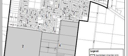
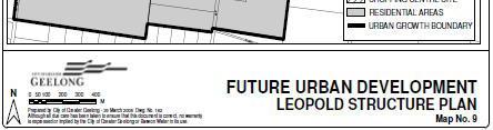
83 Figure 2.3: Future Growth Areas Sourced from the Cityof GreaterGeelongCouncil Website Beca // 17September 2010 // Page // NZ
84 3.1 Development Content Existing Development Details of the existing retail centre have been takenfrom the Tim Nott economic analysis and strategy report dated January The existing development totals 5,800m 2 GFA and includes: 3,290m 2 GFAof supermarket; 140m 2 GFAof speciality food stores; 70m 2 GFAof clothing and footware store; 80m 2 GFAof hardware, home furnishing and electrical store; 490m 2 GFAof other retail; 690m 2 GFAof foodservices; 160m 2 GFAof retail services; 640m 2 GFAof banks, doctors post office etc; and 240m 2 GFAof vacant shops. Access to the existing retail centre is via a left in /left out intersection on Bellarine Highway and an all movement access onto Melaluka Road Proposed Development The Master Plan proposals are to provide a total of approximately 51,100m 2 GFA to create asub- Regional Centre that provides employment and retail opportunities for the Bellarine Peninsula. The proposed floor areas are indicatively broken down as: 10,080m 2 GFAof slow trade store (i.e. furniture, electrical); 8,560m 2 GFAof fast trade (such as direct discount stores); 8,030m 2 GFAof supermarket; 5,630m 2 GFAof speciality stores (such as fashion and fast food); 1,200m 2 GFAof office,medical centres, post office etc; and 17,600m 2 GFAof mixed use commercial containing light industrial, entertainment and office support services. It is anticipated that the new Sub-Regional Centre will include a new, all movement signalised access onto the Bellarine Highway in the vicinity of Clifton Avenue in addition tothe existing access from Melaluka Road. 3.2 Traffic Generation The traffic generation of the existing and proposed land uses, which are predominantly retail uses, is typically greatest during the Thursday PM peak hour and Saturday midday peak hour. Typical traffic generation rates have been taken from the Road and Traffic Authority of New South Wales document A Guide totraffic Generating Developments. The trip ratesfor the retail and commercial elements are summarised below, as is the predicted traffic generation from the existing and proposed lane use scenarios. Beca // 17September 2010 // Page // NZ
85 3.2.1 RetailTraffic Generation The retail traffic generation has been based upon aformula used to determine the likely traffic generation from shopping centres. This formula accounts for the linking of tripsbetween the different stores within the shopping centre. The traffic generation formulas for the Thursday PM peak and Saturday midday peak are: Thursday PM Peak1 1 =(20xAS)+(51xAF)+(155xSM)+(46xASp)+(22xAO) Saturday Midday Peak1 =(38xAS)+(13xAF)+(147xSM)+(107xASp) These formulas have been applied to the existing and proposed land uses identified in Section 3.1. The resulting traffic generation is set out in Table 3.1 and it has been assumed that the arrivalsand departures will be equally split in both time periods, which is typical for retail activities. Table 3.1: Retail Traffic Generation Peak Hour Arrive Depart Total Existing Thursday PM Saturday Midday Proposed Thursday PM ,951 Saturday Midday 1,025 1,025 2,049 In addition to the above, an assessment has been undertaken of the proportion of diverted trips to the retail. Diverted are trips that are already on the road network, but are currently travelling to other destinations. The purpose of the Sub-Regional Centre is to attract retail trips that would otherwise be going to Geelong city. Therefore, we consider a reasonably high proportion of trips currently continuing through togeelong would divert into the site. Based on datafrom the Institute of Traffic Engineers handbook, 20% of trips have been assumed to be diverted during the weekday PM peak and 26% during the Saturday midday peak. Furthermore, aproportion of the trips would be passing the site and would enter as part of atrip chain (i.e. travellinghomefrom work). Based on data from the Instituteof Traffic Engineers handbook, 20% of trips have been assumed to be pass-by duringthe weekday PM peak and 18% during the weekend midday peak. Table 3.2 sets out the resulting new, diverted and pass-by trips associated with the existing and proposed retail. 1 Gross Floor Areas have been reduced to 90% to derivegross Leasable Floor Areas. AS =Slowtrade area, AF =Fasttrade area, SM=Supermarket area, SS =Specialty retail area, AO= Office area Beca // 17September 2010 // Page // NZ
86 Existing Proposed Table3.2: RetailTraffic Generation Peak Hour Trip Type Arrive Depart Total Thursday PM New Diverted Pass-by Total Saturday Midday New Diverted Pass-by Total Thursday PM New ,171 Diverted Pass-by Total ,951 Saturday Midday New ,148 Diverted Pass-by Total 1,025 1,025 2, Commercial Traffic Generation The traffic generation for commercial areashasbeen taken from the Road and Traffic Authority of New South Wales Guide to Traffic Generating Developments. This document includes a Business Parks land use category, which coverslight industrial, manufacturing, office and recreational activity is considered to be a suitable proxy for the commercial element proposed in the Sub-Regional Centre. The following sets out the predicted traffic generation from the commercial development: Weekday Peak hour traffic generation of 1.1trips per 100m 2 GFA=194 trips; Assumed 80% outbound and 20% inbound trips to give155 departing trips and 39 arrivals; and Traffic generationon Saturdays is negligible Traffic Generation Summary The resultant total traffic generation from the proposed Sub-Regional Centre is summarised in Table 3.3. This indicates that the Sub-Regional Centre is predicted to generate between 1,496 and 1,585 additional weekday PM and Saturday peak hour trips respectively compared to the existing site. This is an increase in traffic generation of approximately four times the existing. Beca // 17September 2010 // Page // NZ
87 Table 3.3: Traffic Generation Summary Scenario Peak Hour Peak Hour Traffic Generation Existing Proposed 3.3 Traffic Distribution Thursday PM Peak 560 Saturday Midday Peak 553 Thursday PM Peak 2,145 Saturday Midday Peak 2,049 The traffic distribution to and from the Sub-Regional Centre has been based upon a broad gravity model. Thismodel is based on the populationsof towns on the Bellarine Peninsula, the approximate distance to Leopold and whether these trips are considered likelyto travel towards Leopoldfor retail and employment purposes. Table 3.4 sets out the approach and resulting traffic distribution. Table 3.4: Traffic Distribution Location Direction Route Population Weighting Distribution Leopold East Bellarine H way 8, % Newcomb West Bellarine H way 4, % Whittington West Bellarine H way 4, % Drysdale East Geelong P ton Rd 3, % St Leonards East Geelong P ton Rd 1, % Portarlington East Geelong P ton Rd 3, % Queens Cliff East Bellarine H way 3, % Point Lonsdale East Bellarine H way 3, % Ocean Grove East Bellarine H way 3, % 100% In addition to the above, the traffic distribution for Leopold has been further refined based on the approximate size of to the different urban areas. The refined Leopold traffic distribution is summarised in Table 3.5. Location Table3.5: Leopold Distribution Distribution Melaluka South 6% Melaluka North 3% Kensington North 4% Kensington Central 9% East on Bellarine H way 16% 39% Beca // 17 September 2010 // Page // NZ
88 In summary, the traffic distribution to /from the proposed Sub-Regional Centre is: From the east on the Geelong Portarlington Highway 21%; From the east on the Bellarine Highway 45%; From Leopold on the Geelong Portarlington Road 4%; From Leopold on Melaluka Road North 3%; From Leopold on Melaluka Road South 6%; and From Leopold on Kensington Road 9%; From the west on the Bellarine Highway 12%. 3.4 Closure of Melaluka Road One of the development options includes the closure of the southern end of MelalukaRoad, diverting traffic via a new route around the proposed Sub-Regional Centre and onto a fully formed Clifton Avenue. As identified previously, Melaluka Road is currently considered to be used for access between Geelong Portarlington Road and the Bellarine Highway, because the former provides afaster route toand from Geelong city. Closing the southern end of Melaluka Road will require this traffic to take an alternativeroute, beit entirely along the Bellarine Highway, via the new Clifton Avenue route or via an alternative road such as Kensington Road. The anticipated traffic flows on the surrounding network following the closure of Melaluka Road have been estimated using the following process: Estimate the existing shopping centre traffic onthe surrounding road network; Remove the estimated existing shopping centre traffic from the surrounding road network; Re-Distributethe remaining traffic based upon the remaining turning movementsat the Bellarine Highway / Melaluka Road intersection. This includes: Traffic previously travelling north and south through this intersection has been assigned 50% to /from Geelong using the Bellarine Highway and 50% to Kensington Road; and Traffic turning right into /out of Melaluka Road (north) hasbeen assigned 50% to Kensington Road and 50% to /from Geelong on the Bellarine Highway. The effects of re-routing traffic will be discussed in Section Traffic Assignment The wider traffic assignment has been kept consistent between the scenarios with Melaluka Road open or closed. The main change in traffic assignment is that traffic to /from Melaluka Road south has been assumed to access the site via the Bellarine Highway when Melaluka Road is closed, rather than using Melaluka Road. Beca // 17 September 2010 // Page // NZ
89 4.1 Link Capacity Assessment Link Capacities Indicativelink capacities have been estimated using the Road and Traffic Authority of New South Wales (RTA) Guide to Traffic Generating Developments. Section 4.2 of that document provides indicativepeak hour capacities for strategic planning purposes. These are reproduced in Table 4.1 to indicate the anticipated capacity of the roadswithin the study area of thisassessment. These capacities are considered to be the indicative traffic flow limit prior to flow breakdown occurring because of over-saturation of these links. Table 4.1: Typical Mid-blockOne-way Capacities Road Name Road Type One-way Mid-Block Capacity (vehiclesper hour) Bellarine Highway Divided Dual Carriageway 1,900 Geelong Portarlington Road Divided Dual Carriageway 1,900 Melaluka Road Two-Way Collector Road 900 Kensington Road Two-Way Collector Road 900 Clifton Avenue Two-Way Collector Road 900 Table 4.2 provides an indicativeassessment of the level of service (using data from the RTA guide) on the two road categories identified above. It should be noted that the capacity presented in Table 4.1 has been assumed to represent a level of service of D. Level of Service Divided Dual Carriageway Table 4.2: Indicative Levels of Service Two-Way Collector Road Comments A Freeflow traffic conditions with excellent comfort and convenience for drivers. B Stable trafficflow with good comfort and convenience for drivers. C 1, Stable trafficflow, but with some restriction on speedsand manoeuvrability. Comfort and convenience notably declines at this level. D 1, Close to thelimit of stabletrafficflow. Small increasesin trafficmaycausecongestion. Poor comfort and convenience for drivers. E 2,950 1,400 Trafficisclose toorat capacity. Trafficflowis unstable andminor disturbancescause traffic jams. F >2,950 >1,400 Trafficflow break-down occurs resulting in queuesand delays. Beca // 17 September 2010 // Page // NZ
90
91
92 4.1.3 Link Capacity Results a. Thursday PM Peak The link results indicatethat theinclusion of traffic generated by the Sub-Regional Centreis not predicted to have a significant effect upon link capacity. None of the links are anticipated to operate with alevel of service worse than D and the majority of linksare predictedto be at level of service C. The largest changes in traffic flow are predicted to occur on Melaluka Road, which provides the primary access to the Sub-Regional Centre. The westbound traffic on Bellarine Highway (prior to Melaluka Road) is predicted toincur asignificant increase in traffic of 50%. This is to be expected because alarge portion of the Sub-Regional Centre s catchment isfrom the BellarinePeninsula along the Bellarine Highway. It has been assumed that access will still be provided to the Sub-Regional Centrevia Melaluka Road if this road were to be stopped in order to provide access for traffic to /from the Geelong Portarlington Road. The traffic flows on Kensington Road would be significantlyincreased if this access were not provided. The residual effect of closing Melaluka Road to through traffic is to reduce the overall increase in traffic on Melaluka Road compared to the existing scenario, but to increase southbound traffic on Kensington Road by 60vehicles during the PM peak hour. Whilst this is within the capacity of the road, it is undesirable with regards to adding trafficto aroad that provides direct property access and access to a school. b. Saturday Midday Peak The road network is predicted to operate satisfactorily during the Saturday Midday peak period, with no link havingalevel of service of worse than C. Other than the site accesses, the inclusion of the Sub-Regional Centre traffic on the existing network has the largest effect on the Bellarine Highway. The westbound traffic flow is predicted to increase by 32%, although thisonly creates alevel of service of C, which is considered to be acceptable for a Primary Arterial route. Reductions in traffic on the Geelong Portarlington Road and southbound on Melaluka Road (south) are predicted as aresult of traffic diverting because of the Melaluka Road closure. 4.2 Intersection Capacity Intersection modelling has been undertaken at thetwo intersections that are most likely to be affected by the change in traffic flows resulting from the proposed Sub-Regional Centre. The capacity of the existing Melaluka Road / Bellarine Highway intersection and the proposed Western SiteAccess (Clifton Avenue) / Bellarine Highway intersection has been assessed at ahigh level using the isolated intersection modelling package SIDRA. These model results are indicative only because the base model has not been calibrated or validated. Table 4.5 and Table4.6 summarise the SIDRA results for the Melaluka Road and Western Access intersections respectively. Thefull results are contained in Appendix C and are discussed below. The worst level of service that is assumed to represent satisfactory traffic conditionsis D. Thisis close to the capacity of the intersection, but acceptablefor peak hour trafficflows. Beca // 17 September 2010 // Page // NZ
93 Saturday Midday Peak Thursday PM Peak
94 Saturday Midday Peak Thursday PM Peak
95 4.2.1 Existing Melaluka Road /Bellarine Highway Indicative Operation The indicative modelling of the existing intersection, set out in Table 4.5, identifies the intersection is currently within capacity during the Thursday PM peak and Saturday midday peak. The worst performing approach during both time periodsis Melaluka Road (north), but the operation of this arm is not currently considered to be a concern. Overall, the existing intersection currently operates with an indicative a level of service of C, which is satisfactory Melaluka Road / Bellarine Highway with Sub-Regional Centre Indicative Operation The addition of the full Sub-Regional Centre traffic generation onto the road network is predicted to have significant adverse effects at the Melaluka Road /Bellarine Highway intersection. The Thursday PM peak hour operation is predicted to have three arms over-capacity (a degree of saturation of 1) and the remaining arm is predicted to be over the practical capacity limit (a degree of saturation of 0.9). Extensive queues are predicted on Melaluka Road (north) and Bellarine Highway (west). Overall, this intersection is predicted to operate at a level of service of F, which is unacceptable, given the existing level of operation and suggested minimum performance level. The Saturday Midday peak hour intersection model predicts that the Bellarine Highway (east) approach will be the only arm over capacity, but Melaluka Road (north) and the Bellarine Highway (west) will be approaching practical capacity. Overall, this intersection ispredicted tooperate at a level of service of D, which is the minimum performance level suggested for this study. In summary, the indicative intersection capacity results predict that the Melaluka Road / Bellarine Highway intersection would require improvements to satisfactorily accommodate the proposed Sub- Regional Centre. These improvements would likely include widening to Melaluka Road north and extending thelength of the right turnfrom the Bellarine Highway (west) into Melaluka Road (north) Melaluka Road /Bellarine Highway with Sub-Regional Centre (No Melaluka Road) Indicative Operation The indicative operation of the Melaluka Roadintersection is predicted to be marginally better if Melaluka Road is closed to through traffic. However, the intersection modelling results predict that this intersection would be over-capacity with the Sub-Regional Centre traffic added to the network. Most notably, the Bellarine Highway (east) approach is predicted to be over-capacity and all other arms would be over the practical capacitythreshold. Overall, thisintersection is predicted to operate at alevel of service of E with the Sub-Regional Centretraffic added tothe road network and Melaluka Road closed tothrough traffic. The Saturday midday peak hour results indicate that this intersection ispredicted to operate marginally worse with Melaluka Road closed to through traffic. The Bellarine Highway (east) approach is predicted to be over-capacity and the Melaluka Road (north) approach to be over the practical capacity threshold. Overall, the intersection is predicted to operate at a level of service of E during the Saturday midday peak, which is unsatisfactory given the existing level of operation and suggested minimum performance level. In summary, closure of Melaluka Road to through traffic has a marginal effect on the operation of this intersection with the Sub-Regional Centretraffic added to the road network when compared to maintaining Melaluka Road as a through route. The same intersection improvements as highlighted in Section are anticipated to be required with the Melaluka Road closure. Beca // 17 September 2010 // Page // NZ
96 4.2.4 Western Site Access / Bellarine Highway Indicative Operation The layout of thewestern Site Access / Bellarine Highway intersection has been assumed as set out in Figure 4.1. This intersection is predicted to have good operation in both peak periods tested (with and without the closure of Melaluka Road to through traffic). The intersection ispredicted to operate with a level of service of B in all scenarios. However, the predicted queue lengths from the Melaluka Road /Bellarine Highway intersection during the Thursday PM peak (discussed in Section and Section 4.2.3) would interfere with the operation of the western site access intersection unless the suggested improvements are made to the Melaluka Road / Bellarine Highway intersection. Figure 4.1: Indicative Western Site Access Layout 4.3 Summary of Traffic Effects Link Capacity Summary The existing road network operates satisfactorily with regard to linkcapacity with nolinks operating worse than level of service D. The inclusion of Sub-Regional Centre traffic on the road network does not result in significant effects with regard to link capacity. The closure of Melaluka Road reduces trafficflows on the Geelong Portarlington Road because some traffic is anticipated to divert to the Bellarine Highway. Similarly, traffic flows are predicted to increase on Kensington Road because this provides an alternative north-south link to Melaluka Road. The closure of Melaluka Road to through trafficis considered unacceptable because of the increase in traffic on Kensington Road. Beca // 17 September 2010 // Page // NZ
97 4.3.2 Intersection Capacity The existing Melaluka Road / Bellarine Highway intersection operates satisfactorily, but the capacity of this intersection is exceeded with the inclusion of Sub-Regional Centre generatedtraffic. The closure of Melaluka Road to through traffic is predicted to have a marginal effect on the operation of this intersection compared to keepingthislink open. It is anticipated that the existing intersection would require improvements to satisfactorily accommodate the proposed Sub-Regional Centre. These improvements would likely include widening to Melaluka Road (north) and extending thelength of the right turnfrom the Bellarine Highway (west) into Melaluka Road (north). The proposed Western Site Access (Clifton Avenue) intersection is predicted to operate satisfactorily, but the queues from the MelalukaRoad /Bellarine Highway intersection during the Thursday PM peak are predicted to extend through the Western Access intersection unless the above improvements aremade. Beca // 17 September 2010 // Page // NZ
98 5.1 Strategic Objectives Thefollowing sets out the strategic transport objectives that should be sought from thefuture development of the Sub-Regional Centre, based on the preliminary high level traffic assessment (Section 4), discussions with the Council and the review of theexisting and future road network (Section 2) Melaluka Road Itis considered important tokeep Melaluka Road open, as it provides astrategic role distributing traffic throughout thelocal network. The 60kph speed limit should be kept in thevicinity of the Sub- Regional Centre and extended to the intersection with Geelong Portarlington Road, so that it provides a low speed environment to encourage cycling to /from the Rail Trail. The proposed cross-section for Melaluka Road will be discussed in greater detail in Section 5.2, but it is recommended that the cross-section includes footpaths on both sides of theroad and onroad cycle lanes between the Bellarine Highway and the Geelong Portarlington Road. The cycle lanes should link tothe Rail Trail and the cycle paths on the Bellarine Highway and the Geelong Portarlington Road. Aformal pedestrian crossing point south of Stringers Lane is recommended to provide an opportunity to cross Melaluka Road prior to the site access, where turning traffic will make crossing less safe. It is anticipated this would be apedestrian refuge in Melaluka Road. Thecompletion of Stringers Lane is anticipated to create apedestrian route from the central Leopold area to /from the Sub-Regional Centre Access Locations It is recommended that Melaluka Road remain the primary access to the Sub-Regional Centre, but the layout of shops within the siteshould include an anchor store towards the western end of the site to encourage use of the proposed Western Access. No other accesses are recommended onto the Bellarine Highway to preserve the through trafficfunction of this road, so the existing left in /let out arrangement on the Bellarine Highway could be removed. The western access on the Bellarine Highway is proposed to be anew signalised intersection. This intersection should belocated in thevicinity of the Clifton Avenue intersection to avoid potential queuing issues between the two intersections and minimise the number of access onto the Bellarine Highway. Access to the retail elements at the Sub-Regional Centre should be taken from Melaluka Road at the existing location to tie-in with the access to the Memorial Recreation Reserve opposite. Pedestrian crossing facilities will be particularly important at this intersection to accommodate trips to /from the Sub-Regional Centre. Access to the business park should be kept separatefrom the retail access, as far aspossible. It is recommended that an additional access be constructed on Melaluka Road for business park generated traffic, as indicated in Figure 5.1. A third access could also be created as aservice lane to the back of house facilities of the retail. It is recommended that this be via the western access to reduce the number of heavy commercial vehicles travelling on Melaluka Road, as Melaluka Road is proposed to be the main customer access and cater for pedestrian and cycle movements. Beca // 17 September 2010 // Page // NZ


99 Figure 5.1: Recommended Access Locations Business Park Retail Area Key: Business Park Access Retail Access Service Access Passenger Transport The short to medium term focusfor passenger transport is to utilise services that travel on the Bellarine Highway. However, consideration should also be given to the long term objective of providing apassenger transport interchange in Leopold. The Sub-Regional Centre presentsan opportunity to achieve this, but does require the diversion of bus services away from the Geelong Portarlington Road. Nonetheless, it is recommended that consideration be given to the long term opportunities to provide a bus interchange on this site. The internal road network of the Sub-Regional Centre should accommodate buses travelling through the site, which will require an internal spine road. It is recommended that existing bus services on the Bellarine Highway be diverted through the site and stop outside one of the anchor stores, preferably near the central retail area. The routing of buses through the site is not considered to be asignificant diversion and should not greatly increase the travel times. Bus stops internal to the site should include attractive waiting facilities to encourage patronage. External bus stops could also be provided on the Bellarine Highway to accommodate stops from any express services that are proposed between the Bellarine Peninsula and Geelong, which would not be anticipated to divert. Again, the external bus stops should include shelters and timetable information as aminimum provided by this development. These stops have been recommended as being adjacent to the Melaluka Road access, so that passenger will be able to use the pedestrian crossing facilities at the signalised intersection. Beca // 17 September 2010 // Page // NZ


100 The passenger transport recommendations are indicatively illustrated in Figure 5.2. Figure 5.2: Passenger Transport Recommendations Key: Site Boundary Through Site Route Express Route Future Bus Link Bus Stop Locations Cycle Routes As proposed in eth Councils transport strategy, cycle routes should be provided on Melaluka Road between the Geelong PortarlingtonRoad and the Bellarine Highway. It is recommended that this be an on-road facility with marked cycle lanes. TheBellarine Highway / Melaluka Road and Bellarine Highway / Site Access intersections should include advanced cycle boxes to enable cyclists to turn into and out of the Sub-Regional Centre. Cycle parking should be provided at key locations within the Sub-Regional Centre to accommodate cycle trips to theretail and the business park for staff and customers. Ideally, the cycle parking will be located close to building entrances, where it is undercover and over looked. The retail and business park should also include shower and locker facilities for the staff Pedestrian Routes Footpaths should be provided along both sides of Melaluka Road between the Geelong Portarlington Road and the Bellarine Highway. As discussed in Section 5.1.1, pedestrian crossings should be provided south of Stringers Lane on Melaluka Road to encourage pedestrians to cross prior to the Sub-Regional Centre access. An additional crossing should be provided at the Sub- Regional Centre access on Melaluka Road to provide safe crossing between the site and the Memorial Reserve opposite. Pedestrian routes should be provided through the car parks to safely accommodate walking to and from parked vehicles. These pedestrian routesshould link to the existing crossings at the Melaluka Road / Bellarine Highway intersection to provide direct pedestrian access between the centre of the site and the external pedestrian network. The pedestrian routes should be well lit and over looked to provide safe and secure routes. Beca // 17 September 2010 // Page // NZ
101 5.1.6 Car Parking Provision The car parking provision at the Sub-Regional Centre needs to be balanced such that it is sufficient to accommodate the traffic demand, but not provide an excess of parking. It is understood that a parking provision between 3.4 and 4.6 car parks per 100m 2 are typical for shopping centres in the Geelong municipality (as advised by the Council), although the planning requirement isfor 8per 100m 2. This should be used as the initial basisfor theparking requirement for the retail activities. The business park car parking requirements will need to be assessed further when the details of the tenancies are clarified. However, it is considered that aparking ratioof 1.5 car parks per 100m 2 of gross leasable area is a suitable indicative requirement. This creates a total parking requirement of approximately 1,600 spaces for the Sub-Regional Centre. The car parking should include mobility parking and mother and child parking for retail uses. These should be provided adjacent to themain entrances and be wider bays to facilitate access to vehicles. 5.2 Recommended Road Cross-Section Melaluka Road Cross-Section The existing daily traffic flows on Melaluka Road are in excess of 3,000 vehicles per day with the Sub-Regional Centre traffic added to the road network. Assuch, this road requiresminimum lane widths of 3.5m in both directions, based on AustRoads requirements. An additional 1.5m onboth sides of the road is proposed to accommodate on-road cycle lanes. Furthermore, on-street parking should be provided to accommodate visitor trips to residential properties on Melaluka Road and potential overspill parking from the Sub-Regional Centre during exceptional trading periods, such as Christmas. Footpaths and berms are recommended for both sides of Melaluka Road. The footpaths are recommended to be of 2.0m minimum width with a2.3m wide berm toprovide 4.3m urban border in accordance with AustRoads. The overall corridor width recommended for Melaluka Road is 24.2m, including: 2 x 3.5m wide traffic lanes; 2x1.8m wide on-road cycle lanes; 2x2.5m wide parking lanes; 2x2.3m landscaped berm; and 2x2.0m wide footpaths Clifton Avenue Cross-Section Clifton Avenue is predicted to have lower traffic flows than Melaluka Road, but it is likely to provide access to the industrial activities in the business park. Cycle lanes are not proposed on Clifton Avenue, other than at the intersection with the Bellarine Highway. Inaddition, it is considered that the footpath requirements on Clifton Avenue can be reduced compared to that recommended on Melaluka Road, because this will be a less pedestrian focussed area. The overall corridor width recommended for Clifton Avenue is 22.6m, comprising: 2 x 4.2m wide traffic lanes; 2x2.5m wide parking lanes; 2x3.1m berm; and Beca // 17 September 2010 // Page // NZ
102 2x1.5m wide footpaths. Additional widening will be required at the bend between Clifton Avenue and the proposed business park access road to accommodate heavy commercial vehicle manoeuvring. 6.1 Development Land Use Proposals The Master Plan proposals are to increase provide atotal of approximately 51,100m 2 GFA to create a Sub-Regional Centre that provides employment and retail opportunities for the Bellarine Peninsula. The proposed floor areas are indicatively broken down as: 10,080m 2 GFAof slow trade store (i.e. furniture, electrical); 8,560m 2 GFAof fast trade (such as direct discount stores); 8,030m 2 GFAof supermarket; 5,630m 2 GFAof speciality stores (such as fashion and fast food); 1,2000m 2 GFAof office, medical centres, post office etc; and 17,600m 2 GFAof mixed use commercial containing light industrial, entertainment and office support services. The traffic generation of the existing siteand the proposals are summarised in Table 6.1, which shows that the Sub-Regional Centreis predicted to generate between 1,496 and 1,585 additional weekday PM and Saturday peak hour trips compared to the existing site. Table 6.1: Traffic Generation Summary Scenario Peak Hour Peak Hour Traffic Generation Existing Proposed Thursday PM Peak 560 Saturday Midday Peak 553 Thursday PM Peak 2,145 Saturday Midday Peak 2, Road Capacity Review Link Capacity Summary The existing road network operates satisfactorily with regard to linkcapacity with nolinks operating worse than level of service D. The inclusion of Sub-Regional Centre traffic on the road network does not result in significant effects with regardto link capacity. The closure of Melaluka Road reduces trafficflows on the Geelong Portarlington Road because some traffic is anticipated to divert to the Bellarine Highway. Similarly, traffic flows are predicted to increase on Kensington Road because this provides an alternative north-south link to Melaluka Road. This increase in traffic was considered to be unacceptable, especiallybecause the proposed growth in Leopold is likely to add to through traffic on Melaluka Road Intersection Capacity The existing Melaluka Road / Bellarine Highway intersection operates satisfactorily, but the current capacity of this intersection is exceeded with the inclusion of Sub-Regional Centre generated traffic. Beca // 17 September 2010 // Page // NZ
103 The closure of Melaluka Road to through traffic is predicted to have a marginal effect on the operation of this intersection compared to keeping this link open. It is therefore anticipated that the intersection would require improvements to satisfactorily accommodate the proposed Sub-Regional Centre. These improvements would likely include widening to Melaluka Road (north) and extending thelength of the right turnfrom the Bellarine Highway (west) into Melaluka Road (north). The proposed Western Site Access (Clifton Avenue) intersection is predicted to operate satisfactorily, but the queues from the MelalukaRoad /Bellarine Highway intersection during the Thursday PM peak are predicted to extend through the Western Access intersection unless the above improvements aremade. 6.3 Strategic Objectives Melaluka Road It is important to keep Melaluka Road open, as it provides a strategic role distributing traffic throughout the local network. The 60kph speed limit should be kept in thevicinity of thesub- Regional Centre and extended to the intersection with Geelong Portarlington Road, so that it provides a low speed environment to encourage cycling to /from the Rail Trail Access Locations MelalukaRoad should provide the primary access to the Sub-Regional Centre; Anew signalised intersection should be provided at CliftonAvenue to provide awestern access to the site; An anchor store should be provided toward the western end of the site to encourage traffic to use the western access; No additional accesses should be provided on the Bellarine Highway to preserve the through traffic function of this road; and Access to the business park and retail areas should be separated, as far as possible Passenger Transport The site should accommodate through busservicesfrom the Bellarine Highway on an internal spine road; Bus stops should be provided at the heart of the site and adjacent to themelaluka Road / Bellarine Highway intersection; and Consideration should be given to the long term potential of creating apassenger transport interchange at the site Cycle Routes On-road cycle routes should be provided on Melaluka Road, as proposed in the Geelong Transport Strategy; and The Sub-Regional Centre should include cycle parking (for staff and customers) as well as showers and locker facilities for staff Pedestrian Routes Footpaths should be provided for along bothsides of Melaluka Road, between the Geelong Portarlington Road and the Bellarine Highway; Amid-block pedestrian crossing should be provided on Melaluka Road between Stringers Lane and the site access; Beca // 17 September 2010 // Page // NZ
104 Pedestrian crossings should be maintained at the Melaluka Road / Bellarine Highway intersection; Additional pedestrian crossings should be provided at the site access between the Memorial Reserve and the Sub-Regional Centre; and Pedestrian routes within the site should be well lit and overlooked and connect between the centre of the site and the external pedestrian network Car Parking The retail car parking needs to balance providing sufficient spaces to accommodate demand, but not result in an over-provision; The business park car parking requirement needs to be determined when the detail of tenancies in better understood; and Approximately 1,600 car parks will be required at the Sub-Regional Centre. 6.4 Recommended Road Cross-Sections Melaluka Road Cross-Section The overall corridor width recommended for Melaluka Road is 20m, including: 2 x 3.5m wide traffic lanes; 2x1.8m wide on-road cycle lanes; 2x2.5m wide parking lanes; and 2x2.0m wide footpaths Clifton Avenue Cross-Section The overall corridor width recommended for Clifton Avenue is 17m, comprising: 2 x 4.2m wide traffic lanes; 2x2.5m wide parking lanes; and 2x1.5m wide footpaths. Additional widening will be required at the bend between Clifton Avenue and the proposed business park access road. Beca // 17 September 2010 // Page // NZ
105 AppendixA Indicative Master Plan Layout
106
107 Appendix B Traffic Flow Diagrams
108 Clifton Ave Melaluka Rd Vicarage Rd Kensington Rd
109 Clifton Ave Melaluka Rd Vicarage Rd Kensington Rd
110 Clifton Ave Melaluka Rd Vicarage Rd Kensington Rd
111 Clifton Ave Melaluka Rd Vicarage Rd Kensington Rd
112 Clifton Ave Melaluka Rd Vicarage Rd Kensington Rd
113 Clifton Ave Melaluka Rd Vicarage Rd Kensington Rd
114 Appendix C Intersection Modelling Results
115
116
117
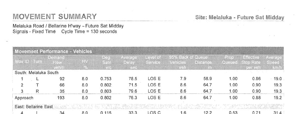
118
119
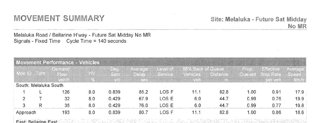
120
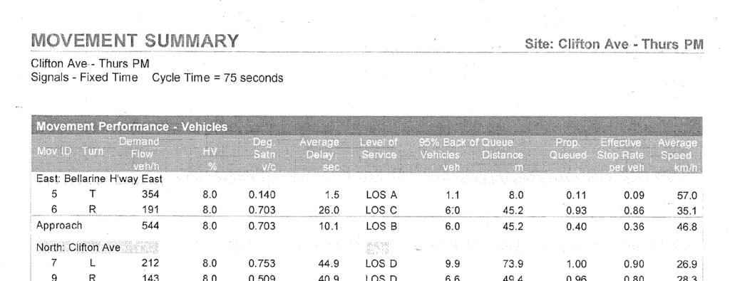
121
122
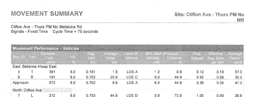
123
124
21.07 ECONOMIC DEVELOPMENT AND EMPLOYMENT 19/03/2015 C323 Proposed C Key issues and influences. Economic Role and Function
 21.07 ECONOMIC DEVELOPMENT AND EMPLOYMENT 19/03/2015 C323 Proposed C347 21.07-1 Key issues and influences 14/10/2010 C168 Economic Role and Function Geelong is the largest regional city in Victoria and
TOWN PLANNING SUBMISSION TO THE GREATER SYDNEY COMMISSION LANDS AT ARTARMON
 TOWN PLANNING SUBMISSION TO THE GREATER SYDNEY COMMISSION LANDS AT ARTARMON March 2017 TABLE OF CONTENTS 1.0 INTRODUCTION 3 2.0 THE SUBJECT SITE 4 3.0 STRATEGIC PLANNING CONTEXT 6 4.0 SUMMARY AND CONCLUSIONS
This economic statement provides analysis with respect to land at Tarneit North, and has been prepared on behalf of Amex Corporation.
 Memorandum To: From: Amex Corporation c/- Greg Wood, Tract Consultants Matthew Lee Cc: Date: 12 June 2013 Subject: Economic Statement for Amex site Tarneit North PSP Dear Greg, This economic statement
URBAN DESIGN REPORT. Proposed Residential Development, Old Church Road, Caledon East
 Proposed Residential Development, Old Church Road, Caledon East TABLE CONTENTS: 1.0 DEVELOPMENT 1.1 Introduction-Analysis of Guiding Principles and Documents 1.2 Community Design and Architectural Design
The Sunshine Coast is part of the global community and generates wealth through export, high-value industries and new investment.
 3.2 Strategic intent 3.2.1 Shaping growth an overview In 2031, the Sunshine Coast is renowned for its vibrant economy, ecological values, unique character and strong sense of community. It is Australia
Gateway Plaza Leopold, VIC
 Economic Impact Assessment for Future Expansion Updated with discussion of Stages 1 & 2 May 2012 MacroPlan Dimasi MELBOURNE Level 4 356 Collins Street Melbourne VIC 3000 (03) 9600 0500 BRISBANE Level 15
Llandudno Junction. Regeneration Proposals for the Future. December 2009
 Llandudno Junction Regeneration Proposals for the Future December 2009 Llandudno Junction - Vision Statement 1 Purpose 1.1 The purpose of this document is to describe key priorities to support the regeneration
Lara Structure Plan. Retail Development Issues
 Lara Structure Plan Retail Development Issues For The City of Greater Geelong March 2009 Economic Analysis + Strategy Report Data Version Date Approved By Sent to Draft Final 11 March 2009 16 March 2009
SUBURBPROFILE POPULATION TO DOUBLE OV E RVIE W CITY OF WY ND H AM FORECAST POPULATION WYNDHAM CITY COUNCIL
 TA R NI E T 1 SUBURBPROFILE The suburb is located within the boundaries of the City of Wyndham which is one of the fastest growing municipalities in Victoria and the third fastest in Australia. OV E RVIE
9.1 INTRODUCTION 9.2 EXISTING DEVELOPMENT. Southern Cross University
 Property Strategy The property strategy delivers improved legibility, responds to the locational attributes of the site, and facilitates essential operational efficiencies. 9.1 INTRODUCTION Non-aviation
Beveridge North West PSP Retail and Needs Assessment
 Beveridge North West PSP 1059 Retail and Needs Assessment Prepared for Metropolitan Planning Authority by Essential Economics Pty Ltd A u g u s t 2 0 1 4 Authorship Report stage Author Date Review Date
DISCOVER YOUR TRUE NATURE
 DISCOVER YOUR TRUE NATURE PAGE 2 ASHBURY ARMSTRONG CREEK GEELONG THE BEST IN TOWN & COUNTRY A healthy, happy lifestyle is all about balance. Having a sense of community and self. Space to relax mixed with
Regional Town Centre and Employment Land Assessment
 Regional Town Centre and Employment Land Assessment PSP 1067 Donnybrook PSP 1096 Woodstock PSP 25.2 English Street Prepared for Metropolitan Planning Authority by Essential Economics Pty Ltd J u n e 2
CAIRNS RECTANGULAR PITCH STADIUM NEEDS STUDY PART 1 CAIRNS REGIONAL COUNCIL DRAFT REPORT SEPTEMBER 2011
 CAIRNS RECTANGULAR PITCH STADIUM NEEDS STUDY PART 1 CAIRNS REGIONAL COUNCIL DRAFT REPORT SEPTEMBER 2011 CAIRNS RECTANGULAR PITCH STADIUM NEEDS STUDY PART 1 Cairns Regional Council September 2011 Coffey
CITY RAIL LINK. New Public Transport Stations and Development Opportunities at Karangahape Road, Newton and Aotea Quarter
 134 AC_BEU_CCMP_3_TM5_8_FD.indd 134 20/07/12 12:30 PM 05 CITY RAIL LINK New Public Transport Stations and Development Opportunities at Karangahape Road, Newton and Aotea Quarter 5 MO VE 0 1 2 8 KEY 1 Britomart
Spadina Avenue Built Form Study Preliminary Report
 STAFF REPORT ACTION REQUIRED Spadina Avenue Built Form Study Preliminary Report Date: July 9, 2014 To: From: Wards: Reference Number: Toronto and East York Community Council Director, Community Planning,
GUNGAHLIN TOWN CENTRE
 GUNGAHLIN TOWN CENTRE PLANNING REFRESH SNAPSHOT NOVEMBER 2018 CONTENTS INTRODUCTION....1 Australian Capital Territory, Canberra 2018 This work is copyright. Apart from any use as permitted under the Copyright
Schedule of Planning Applications Committee Date: 23 May Reference: 06/18/0064/F Great Yarmouth Officer: Mr J Beck Expiry Date:
 Schedule of Planning Applications Committee Date: 23 May 2018 Reference: 06/18/0064/F Great Yarmouth Officer: Mr J Beck Expiry Date: 24-04-2018 Applicant: Proposal: Site: Mr Mavroudis Clear weather hoardings
Land Management Summary
 photo credit: ANGAIR Anglesea Heath Land Management Summary The Anglesea Heath (6,501 ha) was incorporated into the Great Otway National Park in January 2018. This provides an opportunity to consider the
PSP 75 Lancefield Road. Northern Jacksons Creek Crossing Supplementary Information
 PSP 75 Lancefield Road Northern Jacksons Creek Crossing Supplementary Information September 2017 The northern crossing of Jacksons Creek proposed within the Lancefield Road PSP is a key part of the ultimate
Rockbank PSP. Activity Centres Review. May Prepared for. Metropolitan Planning Authority. Essential Economics Pty Ltd
 Rockbank PSP Activity Centres Review Prepared for Metropolitan Planning Authority by Essential Economics Pty Ltd May 2 0 1 4 Authorship Report stage Author Date Review Date Draft report Sean Stephens 14
Airport Planning Area
 PLANNING AREA POLICIES l AIRPORT Airport Planning Area LOCATION AND CONTEXT The Airport Planning Area ( Airport area ) is a key part of Boise s economy and transportation network; it features a multi-purpose
STONES CORNER SUBURBPROFILE. Situated three kilometres from the Brisbane CBD, Stones Corner is located within one of Brisbane s key growth areas.
 1 SUBURBPROFILE Situated three kilometres from the Brisbane CBD, Stones Corner is located within one of Brisbane s key growth areas. OVERVIEW Situated three kilometres from the Brisbane CBD, Stones Corner
PCAL Case Study Retail Areas: Rouse Hill Town Centre
 PCAL Case Study Retail Areas: Rouse Hill Town Centre Introduction Rouse Hill Town Centre is a new mixed use development on a greenfield site in Sydney s North West. It has been planned to be a major hub
Review of Government Secondary School Requirements within the Sunbury South Precinct Structure Plan
 Review of Government Secondary School Requirements within the Sunbury South Precinct Structure Plan Expert Witness Statement August 11 th, 2017 Prepared by Robert Panozzo Director, ASR Research Pty Ltd
Amendments C207 & C208
 Amendments C207 & C208 Hume Planning Scheme Julia Bell August 2017 Instructed by KING&WOOD MALLESONS On behalf of Hume City Council Amendments C207 & C208 Hume Planning Scheme Contents 1.0 Introduction...
Pre-application submission for Committee: Phase 4 development at West Hendon
 Pre-application submission for Committee: Phase 4 development at West Hendon 1. Development Details Phase 4 of the West Hendon Estate Regeneration. 2. Background The redevelopment of the West Hendon Estate
Connecting Sydney Olympic Park and GPOP with Greater Sydney. Final Summary Report 29 May 2017
 Connecting Sydney Olympic Park and GPOP with Greater Sydney Final Summary Report 29 May 2017 GPOP sits at the core of the emerging Central City. East Sydney is at the centre of the established Eastern
The Challenges for the European Tourism Sustainable
 The Challenges for the European Tourism Sustainable Denada Olli Lecturer at Fan S. Noli University, Faculty of Economy, Department of Marketing, Branch Korça, Albania. Doi:10.5901/mjss.2013.v4n9p464 Abstract
JOINT CORE STRATEGY FOR BROADLAND, NORWICH AND SOUTH NORFOLK EXAMINATION MATTER 3C EASTON/COSTESSEY
 Matter 3C Easton/Costessey Representor No. 8826 JOINT CORE STRATEGY FOR BROADLAND, NORWICH AND SOUTH NORFOLK EXAMINATION MATTER 3C EASTON/COSTESSEY SUBMISSION ON BEHALF OF TAYLOR WIMPEY DEVELOPMENTS AND
Creating a High Quality Business District
 Date Month Date Month Friday 7 November 2014 Nine Elms on the South Bank A Bilfinger Real Estate company Creating a High Quality Business District New London Architecture Introduction Nine Elms Vauxhall
CANNING CITY CENTRE. the new energy of the southeast
 CANNING CITY CENTRE the new energy of the southeast 2 INTRODUCTION From early beginnings as an important cultural and recreation place for the Beeloo Nyoongar people, to being a trading post connecting
VICTORIA QUAY COMMERCIAL PRECINCT PLAN
 VICTORIA QUAY COMMERCIAL RECINCT LAN AUGUST 2014 2.0 Introduction 10 2.0 INTRODUCTION 2.1 The role of an Enabling recinct lan A recinct lan provides a clear assessment framework for development. in relation
SOUTH WORCESTERSHIRE DEVELOPMENT PLAN - PREFERRED OPTIONS 2011: SCHEDULE OF ISSUES AND RECOMMENDED RESPONSES Row No.
 1. Inadequate justification Existing retail floor space is underused so no point in extending retail floor space. Instead, would prefer to have sympathetic housing development in the City Centre to attract
The implementation of this Master Plan will be undertaken in logical stages to meet passenger and workforce demands.
 The implementation of this Master Plan will be undertaken in logical stages to meet passenger and workforce demands. Connecting People Building Opportunities 198 Brisbane Airport Corporation CHAPTER 10
Glen Innes Strategic Plan
 Glen Innes Strategic Plan 2018-2023 Photo credit: DKO Architecture Vision Statement Competitive Advantage Located at the heart of the greatest urban transformation project in New Zealand, the Glen Innes
EDEN PARK REDEVELOPMENT COMPLETED STADIUM DESIGN
 1 INTRODUCTION New Zealand was awarded the Rugby World Cup 2011 hosting rights in November 2005. A condition of the winning bid was the provision of a 60,000 seat stadium for the finals. New Zealand s
Proposal for gypsy and traveller accommodation on land at Lower Hollow Copse (Pot Common), Copthorne. Statement of Community Involvement
, Copthorne. Statement of Community Involvement") Proposal for gypsy and traveller accommodation on land at Lower Hollow Copse (Pot Common), Copthorne Statement of Community Involvement Prepared by WYG Environment Planning Transport Ltd on behalf of the
Proposal for gypsy and traveller accommodation on land at Lower Hollow Copse (Pot Common), Copthorne Statement of Community Involvement Prepared by WYG Environment Planning Transport Ltd on behalf of the
Kilometres. Blacktown. Penrith. Parramatta. Liverpool Bankstown. Campbelltown
 0 5 10 15 20 Kilometres Penrith Blacktown Parramatta Liverpool Bankstown Campbelltown accessibility outcomes Legend Outcomes targeted in Western Sydney are: public transport that is accessible throughout
ASCOT SUBURB PROFILE
 ASCOT SUBURB PROFILE CONTENTS SUBURB HIGHLIGHTS 2 3 4 4 5 5 ASCOT & SURROUNDS LOCATION & LIFESTYLE DEMOGRAPHICS EMPLOYMENT FUTURE INFRASTRUCTURE WA MARKET TRENDS ACCESSIBILITY ENTERTAINMENT & RECREATION
5 Rail demand in Western Sydney
 5 Rail demand in Western Sydney About this chapter To better understand where new or enhanced rail services are needed, this chapter presents an overview of the existing and future demand on the rail network
Economic Retail Assessment Shepparton North East Growth Corridor. June Commissioned by City of Greater Shepparton
 June 2012 Commissioned by City of Greater Shepparton This report has been prepared from the office of CPG Level 3 469 La Trobe Street PO Box 305 South Melbourne 3205 T 9993 7888 Issue Date Revision No
Sunshine Coast Council Locked Bag 72 Sunshine Coast Mail Centre QLD Submitted via online portal. 2 June 2017.
 Sunshine Coast Council Locked Bag 72 Sunshine Coast Mail Centre QLD 4560 Submitted via online portal 2 June 2017 Dear Sir /Madam, RE: DRAFT ENVIRONMENTAL AND LIVEABILITY STRATEGY The Green Building Council
DRYSDALE CLIFTON SPRINGS CULTURAL AND COMMUNITY HUB SUB-REGIONAL SPORTS PRECINCT MASTER PLAN
 DRYSDALE CLIFTON SPRINGS CULTURAL AND COMMUNITY HUB SUB-REGIONAL SPORTS PRECINCT MASTER PLAN APRIL 2011 EXECUTIVE SUMMARY The City of Greater Geelong is committed to the development of a sub-regional sports
5 PRECINCT INFRASTRUCTURE PLAN
 The following planning design guidelines should be met. Rainwater tanks are recommended for each dwelling other relevant building structures. Table 10: Category Drainage Drainage Floodplain Management
COLLEGE STREET STUDY Community Consultation Meeting. December 2015
 COLLEGE STREET STUDY Community Consultation Meeting December 2015 2 Agenda 6:30 pm Introductions, Agenda Review and Welcome 6:40 pm Presentation Planning Recommendations 7:30 pm Questions and Discussion
The decision on whether to take enforcement action falls outside the scope of delegated powers.
 5k 16/0031 Reg d: 19.01.2016 Expires: 15.03.201 6 Ward: Nei. 24.02.201 BVPI Full Number of 11/8 On Con. 6 Target Weeks on Target? Exp: Cttee Day: GE No LOCATION: PROPOSAL: TYPE: Phillips Court, 32 Goldsworth
EAST-WEST STITCH. Connecting the Western Edge of the City to the Centre
 98 AC_BEU_CCMP_2_TM1_4 _FD.indd 98 20/07/12 12:06 PM 02 EAST-WEST STITCH Connecting the Western Edge of the City to the Centre 01 02 Northern Motorway Daldy Street Fanshawe Street Nelson Street Hobson
HARBOUR EDGE STITCH. Uniting the Waterfront with the City Centre
 78 AC_BEU_CCMP_2_TM1_4 _FD.indd 78 20/07/12 12:04 PM 01 HARBOUR EDGE STITCH Uniting the Waterfront with the City Centre 01 VISION OUR 2032 VISION IS: Quay Street as a high-quality Harbour Edge space that
COMMUNITY LIFE LEARNING LIFE
 NATURE WARRALILY LIFE Warralily is a unique masterplanned community nestled in a haven of nature, a place that has the perfect balance of modern convenience and signature landscapes to accommodate your
Parkland County Municipal Development Plan Amendment Acheson Industrial Area Structure Plan
 Parkland County Municipal Development Plan Amendment Acheson Industrial Area Structure Plan New Plan Acheson Industrial Area Structure Plan Amendment Parkland County Municipal Development Plan Board Reference
Date: 11 th January, From: Plaistow & Ifold Parish Neighbourhood Plan - Steering Group. Plaistow & Ifold Parish Council
 Date: 11 th January, 2017 From: Plaistow & Ifold Parish Neighbourhood Plan - Steering Group To: Plaistow & Ifold Parish Council Re: Neighbourhood Plan Report to Parish Council Meeting 17 Jan 2017 The Steering
Gold Coast. Rapid Transit. Chapter content. Chapter four Route selection and staging
 Chapter four Route selection and staging Gold Coast Rapid Transit Chapter four Route selection and staging Chapter content Route selection...73 Section one: Helensvale to Griffith University...74 Section
2433 Dufferin Street Zoning By-law Amendment Application - Preliminary Report
 STAFF REPORT ACTION REQUIRED 2433 Dufferin Street Zoning By-law Amendment Application - Preliminary Report Date: July 22, 2014 To: From: Wards: Reference Number: North York Community Council Director,
Public Submissions in response to the Bill closed on 2 July 2015 and Council lodged a copy of the submission provided as Attachment 1.
 54 PLANNING AND ECONOMIC COMMITTEE 8 JULY 2015 3 SUSTAINABLE PORTS DEVELOPMENT BILL Neil Quinn 1/58/14 #4771706 RECOMMENDATION: That Council endorses the Submission made to the Infrastructure, Planning
The Government s Aviation Strategy Transport for the North (TfN) response
 response") The Government s Aviation Strategy Transport for the North (TfN) response Transport for the North Background Good transport links are a crucial part of a strong economy supporting labour markets and delivering
The Government s Aviation Strategy Transport for the North (TfN) response Transport for the North Background Good transport links are a crucial part of a strong economy supporting labour markets and delivering
places Mooloolaba s heart five
 five places the mooloolaba heart 1 Flexible community event use of school oval 2 Enhanced streetscape District cycle route Future cross-block pedestrian link 5 Existing school buildings New signalised
Draft Western District Plan
 Powered by TCPDF (www.tcpdf.org) Draft Western District Plan Submission_id: 31732 Date of Lodgment: 15 Dec 2017 Origin of Submission: Online Organisation name: APP Corporation Pty Ltd Organisation type:
WILLOUGHBY CITY COUNCIL. (02) PO Box 57, Chatswood NSW Victor Street, Chatswood NSW 2067
 PO Box 57, Chatswood NSW Victor Street, Chatswood NSW 2067") WILLOUGHBY CITY COUNCIL (02) 9777 1000 www.willoughby.nsw.gov.au PO Box 57, Chatswood NSW 2057 31 Victor Street, Chatswood NSW 2067 Willoughby Local Centres Position Statement For Discussion 2017 City
WILLOUGHBY CITY COUNCIL (02) 9777 1000 www.willoughby.nsw.gov.au PO Box 57, Chatswood NSW 2057 31 Victor Street, Chatswood NSW 2067 Willoughby Local Centres Position Statement For Discussion 2017 City
Green Fields Leppington
 Green Fields Leppington CONNTENTS 1.0 URBAN GROWTH - SYDNEY 2.0 MACRO CONTEXT 3.0 LOCAL ENVIRONMENTAL PLAN - LEPPINGTON 4.0 CONCEPT 5.0 GREEN ROOFS 6.0 APARTMENT REALISATION SCHEDULE 7.0 INFRASTRUCTURE
Reference: 06/13/0594/F Parish: Fritton & St Olaves Officer: Mrs M Pieterman Expiry Date:
 Schedule of Planning Applications Committee Date: 21 st January 2014 Reference: 06/13/0594/F Parish: Fritton & St Olaves Officer: Mrs M Pieterman Expiry Date: 20-01-2014 Applicant: Proposal: Site: Lord
Draft Greater Sydney Region Plan
 Draft Greater Sydney Region Plan Submission_id: 31392 Date of Lodgment: 14 Dec 2017 Origin of Submission: Online Organisation name: Greenfields Development Company No. 2 Pty Limited Organisation type:
Part four. In this part you will find: The next steps to deliver the master plan
 Part four NEXT STEPS In this part you will find: The next steps to deliver the master plan 6. How COULD the Master Plan be delivered? There are a number of steps required to take the proposals in the master
F6. Coastal Ferry Terminal Zone
 F6. Coastal Ferry Terminal Zone F6.1. Zone description The purpose of the Coastal Ferry Terminal Zone is to provide for the integrated and efficient operation and development of ferry terminal facilities.
East Lancashire Highways and Transport Masterplan East Lancashire Rail Connectivity Study Conditional Output Statement (Appendix 'A' refers)
") Report to the Cabinet Member for Highways and Transport Report submitted by: Director of Corporate Commissioning Date: 1 June 2015 Part I Electoral Divisions affected: All East Lancashire Highways and
Report to the Cabinet Member for Highways and Transport Report submitted by: Director of Corporate Commissioning Date: 1 June 2015 Part I Electoral Divisions affected: All East Lancashire Highways and
La Trobe University Albury-Wodonga Campus Master Plan, March 2017
 La Trobe University Albury-Wodonga Campus Master Plan, March 2017 Company details MGS Architects Established 1985 10-22 Manton Lane Melbourne Victoria 3000 Australia T 03 9291 9900 mgs@mgsarchitects.com.au
Response to the London Heathrow Airport Expansion Public Consultation
 Response to the London Heathrow Airport Expansion Public Consultation Summary This report sets out the response to the Heathrow Airport s consultation on airport expansion and airspace change. The consultation
Public Realm & Landscape
 Town Centre Context Public Realm & Landscape 1. Public realm in the Town Centre varies significantly in quality. Areas of particularly good quality public realm are located around the Minster and outside
Director, Community Planning, Toronto and East York District
 STAFF REPORT October 25, 2005 To: From: : Subject: Toronto and East York Community Council Director, Community Planning, Toronto and East York District Status Report OPA & Rezoning Application 05 117524
Team London Bridge Response to the Department for Transport Consultation on the combined Thameslink, Southern and Great Northern franchise
 Team London Bridge Response to the Department for Transport Consultation on the combined Thameslink, Southern and Great Northern franchise 23 August 2012 Table of Contents 1. Executive Summary 2. Introduction
GET CLOSER TO COMMUNITY VILLAGE RESERVE IN BYFORD HAS A LOT ON OFFER, BUT ONLY FOR A SELECT FEW.
 GET CLOSER TO COMMUNITY VILLAGE RESERVE IN BYFORD HAS A LOT ON OFFER, BUT ONLY FOR A SELECT FEW. Perth Byford Village Reserve is Byford s most centrally located land estate. Steps away from one of the
Infrastructure for Growth
 A passion to deliver a prosperous future Connecting North Cambridgeshire Infrastructure for Growth Infrastructure for growth Wisbech is the largest settlement in Fenland. The town and its hinterland has
Submission on Draft Ingleburn Structure Plan. Prepared for: Ingleburn Chamber of Commerce & Industry Inc. 6 February 2015
 Submission on Draft Ingleburn Structure Plan Prepared for: Ingleburn Chamber of Commerce & Industry Inc. GLN Planning Pty Ltd ABN 39 585 269 237 Level 10, 66 King Street Sydney NSW 2000 GPO Box 5013 Sydney
This is a submission to Council s Delivery Plan and Operational Plan
 Goulburn Mulwaree Council Locked Bag 22 Goulburn NSW 2580 Emailed: strategy@goulburn.nsw.gov.au and council@goulburn.nsw.gov.au Marulan/Tallong Community Network C/O 843 Marulan South Road Marulan NSW,
Mango Hill/North Lakes
 Investment Pack QSA WEALTH & WELLBEING MANAGEMENT 2015 Mango Hill/North Lakes Investment Pack Location This location is 25 kilometres north of Brisbane and is dominated by a series of tranquil lakes. But
OBJECTION TO AMENDMENT TO PLANNING SCHEME AND GRANTING OF PLANNING PERMIT
 PLANNING AND ENVIRONMENT ACT 1987 OBJECTION TO AMENDMENT TO PLANNING SCHEME AND GRANTING OF PLANNING PERMIT AMENDMENT C32 APPLICATION 0873/02 Public Transport Users Association Inc. 247-249 Flinders Lane
E08. Kaufland Stores in Victoria Advisory Committee Epping. Request to be heard?:
 Kaufland Stores in Victoria Advisory Committee Epping E08 Request to be heard?: Yes Full Name: Organisation: Affected property: Attachment 1: Attachment 2: Attachment 3: Comments: Bernard McNamara BMDA
Whangarei Airport. Prepared by Carine Andries 10/20173
 Whangarei Airport Prepared by Carine Andries 10/20173 March 2010 TABLE OF CONTENTS 1 2 3 INTRODUCTION... 3 AIRPORT ROLE AND FUNCTION... 3 AIRPORT FEATURES AND CAPACITY... 3 3.1 3.2 3.3 3.4 3.5 3.5.1 3.5.2
RESPONSE TO AIRPORT EXPANSION CONSULTATION 27 MARCH 2018 Submitted online by Helen Monger, Director
 RESPONSE TO AIRPORT EXPANSION CONSULTATION 27 MARCH 2018 Submitted online by Helen Monger, Director 1. Expanding Heathrow The expansion of Heathrow will be one of the largest infrastructure projects in
ALBANY WATERFRONT STRUCTURE PLAN REPORT. Submitted by Hames Sharley on behalf of LandCorp February 2006
 ALBANY WATERFRONT STRUCTURE PLAN REPORT Submitted by Hames Sharley on behalf of LandCorp February 2006 Albany Waterfront Structure Plan Report - February 2006 1 CONTENTS 1.0 INTRODUCTION 3 1.1 History
CHRISTCHURCH MOTORWAYS. Project Summary Statement February 2010
 CHRISTCHURCH MOTORWAYS Project Summary Statement February 2010 Table of Contents 1. Purpose of Document 2. Strategic Context 3. Benefits 4. Project Scope and Economics 5. Implementation Plan 1 ROADS OF
I508. Devonport Peninsula Precinct
 I508. Devonport Peninsula Precinct I508.1. Precinct description The purpose of the Devonport Peninsula precinct is to provide for the comprehensive residential development of the former Navy housing land
1 INFORMATION REQUIREMENTS
 1 INFORMATION REQUIREMENTS 1.1 BACKGROUND 2 1.2 WHAT IS THE DISTRICT PLAN 3 1.3 DISTRICT PLAN STRUCTURE 4 1.4 HOW TO USE THE DISTRICT PLAN 5 1.5 STRATEGIC FRAMEWORK 6 Whanganui District Plan (15 January
Suburb Profile 200,000 53,000 MARSDEN POPULATION GROWTH LOCATION POPULATION AND DEMOGRAPHICS TRANSPORT AND ACCESSIBILITY MARSDEN
 A DIVISION OF Suburb Profile LOCATION The suburb of Marsden is located approximately 30 minutes from the CBD within the boundaries of the Logan City Council which is one of the largest and fastest growing
A Response to: Belfast On The Move Transport Masterplan for Belfast City Centre, Sustainable Transport Enabling Measures
 West Belfast Partnership 218-226 Falls Road Belfast BT12 6AH T: 02890809202 A Response to: Belfast On The Move Transport Masterplan for Belfast City Centre, Sustainable Transport Enabling Measures Issued
Geelong s future employment precinct is here
 Geelong s future employment precinct is here geelong, victoria, australia grep.com.au Geelong Ring Road Employment PRECINCT Prospectus www.grep.com.au 01 The Geelong Ring Road Employment Precinct offers
Draft Greater Sydney Region Plan
 Powered by TCPDF (www.tcpdf.org) Draft Greater Sydney Region Plan Submission_id: 31119 Date of Lodgment: 12 Dec 2017 Origin of Submission: Online Organisation name: Serapark Pty Ltd Organisation type:
Metropolitan Planning Authority 25-Jul Thompsons Road, Clyde Creek and Casey Fields South (Residential) PSPs 53, 54 & 57.1 Transport Modelling
 PSPs 53, 54 & 57.1 Transport Modelling") Metropolitan Planning Authority Thompsons Road, Clyde Creek and Casey Fields South (Residential) PSPs 53, 54 & 57.1 Transport Modelling Thompsons Road, Clyde Creek and Casey Fields South (Residential)
Metropolitan Planning Authority Thompsons Road, Clyde Creek and Casey Fields South (Residential) PSPs 53, 54 & 57.1 Transport Modelling Thompsons Road, Clyde Creek and Casey Fields South (Residential)
A subsidiary of Metro Property Development SUBURB PROFILE LARA 7TH JUNE 2017
 A subsidiary of Metro Property Development SUBURB PROFILE LARA 7TH JUNE 2017 OVERVIEW Lara is a suburb located in the Greater Geelong Area just 17kms from Geelong and 60kms to the Melbourne CBD. Lara is
Sustainable Urban Development. Presentation to WVCC 1 December 2010
 Sustainable Urban Development Presentation to WVCC 1 December 2010 Introduction Paul Carmody Hindmarsh (Consultation Manager) Tony Adams CB Richard Ellis (Planners) Simon Parsons PTW (Architects) Brett
WILLOUGHBY CITY COUNCIL. (02) PO Box 57, Chatswood NSW Victor Street, Chatswood NSW 2067
 PO Box 57, Chatswood NSW Victor Street, Chatswood NSW 2067") WILLOUGHBY CITY COUNCIL (02) 9777 1000 www.willoughby.nsw.gov.au PO Box 57, Chatswood NSW 2057 31 Victor Street, Chatswood NSW 2067 Willoughby Industrial Lands Position Statement For Discussion 2017 City
WILLOUGHBY CITY COUNCIL (02) 9777 1000 www.willoughby.nsw.gov.au PO Box 57, Chatswood NSW 2057 31 Victor Street, Chatswood NSW 2067 Willoughby Industrial Lands Position Statement For Discussion 2017 City
Calderdale MBC. Wards Affected: Town. Economy and Investment Panel: 20 October Halifax Station Gateway Masterplan
 Calderdale MBC Wards Affected: Town Economy and Investment Panel: 20 October 2016 Halifax Station Gateway Masterplan Report of the Acting Director, Economy and Environment 1. Purpose of the Report 1.1
Tourism 201 CHAPTER 10
 Tourism 201 CHAPTER 10 202 Doncaster Unitary Development Plan Tourism 203 Tourism INTRODUCTION 10.1 The increasing importance of tourism is recognised in the UDP by having its own chapter. The benefits
Bloor Street West Rezoning Application for a Temporary Use By-law Final Report
 STAFF REPORT ACTION REQUIRED 3741 3751 Bloor Street West Rezoning Application for a Temporary Use By-law Final Report Date: June 12, 2007 To: From: Wards: Reference Number: Etobicoke York Community Council
Land off Stonnal Grove, & Rowden Drive (Phase 1A), Lyndhurst Estate, Sutton Road, Erdington, Birmingham, B23 5US
, Lyndhurst Estate, Sutton Road, Erdington, Birmingham, B23 5US") Committee Date: 07/03/2013 Application Number: 2013/00204/PA Accepted: 11/01/2013 Application Type: Reserved Matters Target Date: 12/04/2013 Development Ward: Erdington Land off Stonnal Grove, & Rowden
Committee Date: 07/03/2013 Application Number: 2013/00204/PA Accepted: 11/01/2013 Application Type: Reserved Matters Target Date: 12/04/2013 Development Ward: Erdington Land off Stonnal Grove, & Rowden
West of England. Priority Places Requiring Public Investment
 West of England Priority Places Requiring Public Investment Development Urban Regeneration & Suburban Intensification Bristol Central Area Bristol Central Area; Stokes Croft, Temple Meads & St Philips
November 11, 2009 BY . Planning and Growth Management Department 110 Laurier Avenue West, 4 th Floor Ottawa, Ontario K1P 1J1. Dear Mr.
 November 11, 2009 Planning and Growth Management Department 110 Laurier Avenue West, 4 th Floor Ottawa, Ontario K1P 1J1 BY E-MAIL Attention: Mr. Don Herweyer Dear Mr. Herweyer: Reference: Abbott-Fernbank
CORPORATE ACCOMMODATION SOLUTIONS
 CORPORATE ACCOMMODATION SOLUTIONS TABLE OF CONTENTS EXECUTIVE SUMMARY 3 THE LOCATION 4 KEY FEATURES 5 MASTERPLAN 8 TRANSPORT & PARKING 9 EAST VILLAGE 10 INDICATIVE SCHEME 11 ABOUT THE DEVELOPER 14 2 EXECUTIVE
Report to: Greater Cambridge Partnership Joint Assembly 18 January A10 Foxton level crossing bypass and travel hub
 Report to: Greater Cambridge Partnership Joint Assembly 18 January 2018 Lead officer: Chris Tunstall GCP Director of Transport A10 Foxton level crossing bypass and travel hub 1. Purpose 1.1 The list of
St. Patrick s Street Development Brief
 St. Patrick s Street Development Brief Bardas Chorcai Cork Corporation August 2001 Contents Introduction and background The Development Brief Area Protected and valuable buildings Urban context Objectives