WELCOME. PUBLIC WORKSHOP #3 Fredericksburg Relief Route Study
|
|
|
- Coral Willis
- 5 years ago
- Views:
Transcription
1 WELCOME PUBLIC WORKSHOP #3 Fredericksburg Relief Route Study Sign in so we can keep you updated on the study. View the information boards in the Sanctuary and take a seat. A presentation will begin at the top of the hour. Follow signs to the Social Hall to review route options. Submit your comments by February 8, 2. Take the survey by February 8, 2.
2 Purpose of the Study Identify a Locally Preferred Relief Route Option As traffic volumes on US 29 and congestion in downtown Fredericksburg continue to increase, the need for a relief route has become a critical safety and quality-of-life issue for the community. The task force and project team will engage the public throughout the process in order to help identify a transportation solution that preserves Main Street as the heart of Fredericksburg, minimizes community impacts and reflects community values.
3 Gillespie County Relief Route Task Force Vision Bring a solution to the people. Purpose To identify need, develop and propose a viable solution for a Fredericksburg relief route in order that Fredericksburg citizens may discern true information. Values Be honest. Be candid. Respect others as oneself. Unity in community.
4 Gillespie County Relief Route Task Force MEMBERSHIP City of Fredericksburg Gillespie County Fredericksburg Chamber of Commerce Gillespie County Economic Development Commission Fredericksburg Convention and Visitor Bureau Gillespie County Farm Bureau General Public Representatives
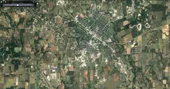
5 87 29 I 965 UV 29 3 Main Street UV Miles.5 2 Fredericksburg Relief Route Project Study Area Expanded Study Area Original Study Area City Boundary

6 St 5 M ila m 2 3 St ry Ch er N Post Oak Rd S Ad am St 2 e liv O S Washington St 2 N Upper LiveOak Rd Bradshaw Ln 6 n Rd Planned Development Camero Cowboy Trl 3 2 Frieden Subdivision 2 Holling Ln Gillespie County Airport Harbin RV Park 52 Majesty Wine Tour Safari Winery German Ln Center Point Rd Cain City Rd Rd io on 9 t An an ds Ol Rocky Hill Ln 4 rr d 62 9 River Rd Longhorn Cellars 5 Riv e 3 6 Old Kerr Hwy Barons Creek Vineyards Wineries RV Center 5 U V Goehmann Ln Otto Eckhardt Rd San A ntonio Road Quiet Dr 2 54 O ld Boos Ln 5 55 Leyendecker Rd V U 5 Holling Ln Oakwood RV Resort RV Park 3 2 Backwoods BBQ Ln ie Fr ip sh nd s St St no Ll a N 6 29 Goehmann Ln 4 5 E Highway St Metzger Rd N Squirrel Run Shortys Ln Homestead Dr Upper LiveOak Rd Kerr Rd Memorial Hospital Heritage School 8 Friendship Ln U V Text Der Stadt Friedhof Cemetery et re 4 W Live Oak St W Live Oak St St Smith Rd n ai M S Bowie St U V Hotel Conference Center 7 Greenwood Cemetery Rd Texas Army National Guard Armory Catholic Cemetery 6 7 Phillips Semmier Rd on ud Lo 5 2 Miles U V Dr Sources: Contours (USGS National Elevation Dataset), Texas Google Imagery, Roadways (TxDOT), Route Options (CP&Y) 6 es con Bal ft Contours Study Area Preliminary Route Options Topographic Map Oa W r kd Rd 8 2 on as M ld O Fredericksburg Relief Route Study
7 TYPICAL PROJECT DEVELOPMENT PROCESS Feasibility Study -2 Years The Feasibility Study includes opportunities for the public to provide input, including public workshops and open houses. Environmental Study and Schematic Design 2+ Years Final Design, Obtain Right of Way, and Adjust Utilities 3+ Years Construction 3+ Years * Advancement from step to step is contingent upon the outcome of the previous step and the availability of funding.
8 WORKSHOP 2 COMMENT OVERVIEW I am against the bypass. Please use commercial properties and stay away from historical family homesteads. Keep cost as low as possible. The shortest route is best. It will minimize cost and environmental impact, encourage Fredericksburg to remain compact rather than sprawl, and it the most cost-effective option. It's also short enough that trucks will actually utilize it. "Please make a final decision as soon as possible so that all who will be affected can make the difficult decisions that will follow." Please move this route out as far as possible to allow Fredericksburg to expand within the loop. "Everybody agrees that large trucks need to be re-routed around Main Street." "Balanced access accomplishes the goal of traffic relief and at the same time allows the city to benefit our residents from tourist's dollars." Use Friendship Lane. "I understand the need for a truck by-pass for the city. I hope the decision-makers will plan for future as well as current growth, and for preserving our heritage." "Although it seems obvious that the shorter routes would involve less cost, how that relates to specific tax payers isn't clear." * Comments shown reflect a representative sampling and are not all-encompassing.


9 Existing Main Street Traffic Approximately, vehicles per day (average) Approximately,6 trucks per day (average) Based on existing traffic volumes, a relief route would divert approximately 6,5 vehicles away from Main Street per day. Of the 6,5 vehicles from Main Street, approximately, would be trucks (about 6% of existing truck traffic). Projected Main Street Traffic If a relief route is not built, it is expected that traffic on Main Street would continue to increase over the next 2 years, with a corresponding increase in truck traffic. A more detailed traffic analysis will be conducted as part of future phases of this study.

10 TRUCKS THROUGH FREDERICKSBURG TRUCK TYPES IN THE AREA Main Street US 87 south of US 29 US 29 east of US 87 37% 5% 5% 5% 5% 63% STANDARD TRUCK TRACTOR-TRAILER STANDARD TRUCK PERCENTAGE OF TRUCKS CARRYING HAZARDOUS MATERIALS MAIN STREET US 87 SOUTH OF US 29 US 29 EAST OF US % 6.67% 2.2% TRACTOR-TRAILER Source: Texas A&M Transportation Institute
11 5 US 29 CRASH SUMMARY January 2 to April West (Loudon to Kay St.) Central (Kay St. to Washington St.) East (Washington St. to FM 376) Total Crashes Crashes Per Mile Injury Crashes Per Mile Total Fatal Crashes 5 PLEASE NOTE: The West segment of US 29 is 3.4 miles, the Central segment of US 29 is.4 miles, and the East segment of US 29 is 5.3 miles. Source: TxDOT


12 AREA GROWTH
13 ECONOMIC GROWTH TOTAL NUMBER OF JOBS IN FREDERICKSBURG Total Number of Jobs 5,939 7, Fredericksburg s economy is growing, with a 28% increase in jobs between 2 and 25. Source: United States Census
14 Goals and Objectives Protect and Preserve Property Minimize potential displacements (residential and commerical) Minimize number of divided parcels Minimize right of way required Minimize potential for noise and neighborhood impacts Enhance Accessibility and Mobility Facilitate local (intracity) trips Accommodate bicyclists Accommodate Existing and Projected Traffic Volumes Reduce the volume of trucks using Main Street to travel through downtown Help reduce congestion on Main Street Accommodate projected increases in traffic Enhance Safety Reduce number of large trucks on Main Street Reduce potential for vehicular/pedestrian conflicts on Main Street
15 Goals and Objectives Support Economic Development Minimize negative impacts to existing businesses Maintain accessibility for deliveries to businesses Support new growth opportunities Preserve Unique Character of Downtown Maintain Main Street as a tourist destination and business center Reduce traffic noise Protect historic resources from residual effects of traffic Protect and Preserve Environmental Resources Minimize potential impacts to Environmental Justice (low income and minority) populations Minimize potential impacts to natural environmental features (floodplains, wetlands and waterways) Minimize potential impacts to protected species Minimize impacts to parks and other known Section 4(f) facilities including historic properties
16 TEXAS DEPARTMENT OF TRANSPORTATION Fredericksburg ReliefRoute Route Study Fredericksburg Relief Study m n Potential Study Area Cemeteries Proposed for Development City Limits Schools Creeks M ar s ch all Cr ee k Kiehne Creek Middl e Cree k Study Area Map 87 [ Dr y Cr ee k U V k r ee lo Pa Alt oc Platted Development! ( Fire/EMS Potential Wetlands Government Facility! ( Police yr Floodplain Parks î Places of Worship 5, 2, Feet 4, 3, 965 ek re ec Ho Kie hn y ne ee Cr k Catholic Cemetery U V ek Hotel Conference Center Tow n Cre Texas Army National Guard Armory Greenwood Cemetery 29 [ 29 [ Planned Resort M ied Cr n St re et Barons Creek Winfr 3 ai eek Der Stadt Friedhof Cemetery W Live Oak St Old Fair Park W Live Oak St Sti V U Planned Development Planned Development City Landfill 3 nk Cr ee k Oa Heritage School k Kerr Rd ree kc Upper LiveOak Rd e Liv Memorial Hospital 29 [ [ 87 Upper LiveOak Rd Friendship Ln Backwoods BBQ Oakwood RV Resort ie Fr sh nd ip Ln Salt Branch City Consolidated Warehouse City Water Reclamation Plant RV Park Fort Martin Scott & Texas Ranger Heritage Center 293 Gillespie County Airport Gillespie County Fair Grounds and Race Track Planned Development Lady Bird Johnson Municipal Park and Golf Course University Center Frieden Subdivision Oak Crest Park Harbin RV Park Majesty Wine Tour 29 [ San Old s Na se ek Antonio Road e Cr V U Alstadt Brewing Wineries Safari Winery Pe de rn a les Riv er Longhorn Cellars k Cre e Be ar Not to Scale ue s lt C M ek re Sa eb ac hc re ek 87 [ RV Center Barons Creek Vineyards [
17 Conceptual Route Options! Fredericksburg Relief Route Study Conceptual Route Options! 2 Marschall Creek Honey Creek Texas Army National Guard Armory Dry Creek Hotel Conference Center Catholic Cemetery Winfried Creek Town Creek Main Street Barons Creek 965 Greenwood Cemetery UV Planned Resort 3 UV Palo Alto Creek Kiehne Creek Old Fair Park Der Stadt Friedhof Cemetery 3 City Landfill W Live Oak St W Live Oak St Live Oak Creek Upper LiveOak Rd Stink Creek Upper LiveOak Rd Kerr Rd Planned Development Heritage School Backwoods BBQ Oakwood RV Resort Planned Development Memorial Hospital City Consolidated Warehouse Friendship Ln UV Friendship Ln RV Park City Water Reclamation Plant Middle Creek Route Segments Proposed for Development Platted Development!!! 3! 4! 7! 9! 7! 4!! 8!! 8 5!! Study Area Government Facility Parks Cemeteries City Limits!( Fire/EMS!( Police î nm Places of Worship Schools Creeks yr Floodplain Potential Wetlands Feet 5, 2, 3, 4,! 3!! 5! 8! 9 Salt Branch Palo Alto Creek Palo Alto Creek 293! 5 Gillespie County Airport Lady Bird Johnson Municipal Park and Golf Course Gillespie County Fair Grounds and Race Track Oak Crest Park Planned Development! 2 Frieden Subdivision Fort Martin Scott & Texas Ranger Heritage Center University Center Nasse Creek!! 3! 5 Harbin RV Park! Majesty Wine Tour 29! 8 UV! 6!! 3! 3! 3 87 Pedernales River Old San Antonio Road Alstadt Brewing Safari RV Center Winery Barons Creek Vineyards Longhorn Cellars Wineries 29 Salt Creek Muesebach Creek 376! Mud Creek Bear Creek
 Access would be controlled; driveway connections would be")

18 Conceptual Layout with Frontage Roads Frontage Road Main Lane Main Lane Frontage Road 35 to 4 Right of Way NOTES: ) Access would be controlled; driveway connections would be allowed along frontage roads. 2) It is anticipated that construction would occur in phases. During initial phases, only portions of the roadway depicted here would be constructed. 3) Layouts are not to scale.


19 Conceptual Layout without Frontage Roads Main Lane Main Lane 25 to 3 Right of Way NOTES: ) Access would be controlled; no driveway connections would be allowed. 2) Layouts are not to scale.
20 FRIENDSHIP LANE Representatives from the City of Fredericksburg are available to discuss Friendship Lane
21 WHY CAN T WE USE FRIENDSHIP LANE? The City of Fredericksburg, Gillespie County and TxDOT agreed upon a set of design parameters to guide relief route planning efforts. Parameters include the following: high speed facility (~7 mph) controlled access facility four main lanes frontage roads to maintain local access, where necessary Applying that vision to Friendship Lane would require the following: total roadway reconstruction expanding right-of-way from ft. to approximately 4 ft. displacing homes, businesses and community resources
US 380 FEASIBILITY STUDY
 US 380 FEASIBILITY STUDY Denton County CSJ(s): 0135-10-061, 0135-10-062 Public Meeting(s): January 15 & 22, 2019 WELCOME US 380 Denton County Feasibility Study DALLAS DISTRICT PUBLIC MEETING January 15
Thornton Water Project. Larimer County Route Study and Project Update September 12, 2017
 Thornton Water Project Larimer County Route Study and Project Update September 12, 2017 Purpose of Meeting Provide information on the Thornton Water Project Present the results of the pipeline routing
Chapter 1: Introduction Draft
 Chapter 1: Draft TABLE OF CONTENTS 1... 4 1.6.1 Stakeholder Engagement Plan... 10 Chapter 1 Page 2 TABLE OF EXHIBITS Exhibit 1.1-1 ABIA Annual Growth Since 1993... 5 Exhibit 1.4-1: ABIA Location Map...
Chapter 1: Introduction
 Chapter 1: TABLE OF CONTENTS 1... 4 1.1 Master Plan Study Content... 4 1.2 Purpose and Scope of Master Plan Study... 4 1.3 Airport History and Role... 6 1.4 Airport Location and Service Area... 6 1.5 ABIA
I-35 Reconstruction Project
 I-35 Reconstruction Project Business Community Meeting McLennan County Projects Jodi Wheatley, I 35 Information Specialist, TxDOT John Jasek, PE, Waco Area Engineer, TxDOT Jacob Bell, PE, Project Manager,
US 83 Relief Route. City of La Joya City of Peñitas Hidalgo County. November 15, 2012
 US 83 Relief Route City of La Joya City of Peñitas Hidalgo County November 15, 2012 TxDOT Mission: Work with others to provide safe and reliable transportation solutions for Texas. Public Meeting Agenda
New Guadernales 64 miles
 Cycling Route 64 miles Region: Fredericksburg, Texas Author: Gregory L. Kagay Catalog: 1022.1 Route Elevation Profile 5,000 Feet 4,000 3,000 2,000 Center Point Slope Bat Cave Summit Piedmont de San Antonio
Longmont to Boulder Regional Trail Jay Road Connection DRAFT FINAL REPORT
 Longmont to Boulder Regional Trail Jay Road Connection DRAFT FINAL REPORT December 2018 Project Summary Boulder County, Colorado, in partnership with the City of Boulder, is evaluating options for multi-use
AGENDA ITEM 5 D WAKULLA ENVIRONMENTAL INSTITUTE (WEI) TRAIL FEASIBILITY STUDY
 TRAIL FEASIBILITY STUDY") March 19, 2018 AGENDA ITEM 5 D WAKULLA ENVIRONMENTAL INSTITUTE (WEI) TRAIL FEASIBILITY STUDY TYPE OF ITEM: Action STATEMENT OF ISSUE The Wakulla Environmental Institute (WEI) Trail is one of several trails
March 19, 2018 AGENDA ITEM 5 D WAKULLA ENVIRONMENTAL INSTITUTE (WEI) TRAIL FEASIBILITY STUDY TYPE OF ITEM: Action STATEMENT OF ISSUE The Wakulla Environmental Institute (WEI) Trail is one of several trails
Sundance Square. Liberty Hill, Texas 78642
 RETAIL / OFFICE DEVELOPMENT OPPORTUNITY Bulk Sale of ±24 Acres at $4.00 / sq. ft. Existing Williamson CAD Tax Parcels Property Features Area of high residential development growth Situated at the entrance
FNORTHWEST ARKANSAS WESTERN BELTWAY FEASIBILITY STUDY
 FNORTHWEST ARKANSAS WESTERN BELTWAY FEASIBILITY STUDY EXECUTIVE SUMMARY The 2030 Northwest Arkansas Regional Transportation Plan developed by the Northwest Arkansas Regional Planning Commission (NWARPC)
US 83 FROM NORTH OF THE STARR/ZAPATA COUNTY LINE TO LOMA BLANCA ROAD
 US 83 FROM NORTH OF THE STARR/ZAPATA COUNTY LINE TO LOMA BLANCA ROAD PUBLIC MEETING JUNE 8, 2017 Talk Text Crash 2 AGENDA TECHNICAL PRESENTATION (Roma Area Engineer Eduardo Gracia, P.E.) PROJECT SCHEDULE
HAMPTON ROADS CROSSINGS PATRIOTS CROSSING AND HRBT
 HRTPO Board Meeting March 21, 2013 Agenda ITEM #9: HAMPTON ROADS CROSSINGS PATRIOTS CROSSING AND HRBT Congestion at the Hampton Roads Bridge-Tunnel (HRBT) on I-64 has long been identified as a problem
FORT WORTH DISTRICT. Springtown Area Projects. Loyl C. Bussell, P.E. Acting District Engineer. Thursday, February 8, 2018 Date.
 FORT WORTH DISTRICT Springtown Area Projects Loyl C. Bussell, P.E. Acting District Engineer Photo by Liam Frederick Footer Text Thursday, February 8, 2018 Date Maintaining a Safe System TxDOT is responsible
HIGHWAY RAIL GRADE CROSSING CONSOLIDATION PROGRAM
 HIGHWAY RAIL GRADE CROSSING CONSOLIDATION PROGRAM To decrease unnecessary train traffic exposure to life and property, promote public safety, and improve traffic conditions, the Texas Department of Transportation
THE BIG PICTURE. Week of March 4, Bring your dog. Bring your kids. Bring a picnic and spend the day with us! Free and open to the public.
 We're celebrating Buda's 138th Birthday with free cupcakes and bubble fun! Come hang out with us at the visitor center in Stagecoach Park for a free cupcake donated by our local Walmart and play under
2008 DEKALB COUNTY TRANSPORTATION PLAN (UPDATE)
") 2008 DEKALB COUNTY TRANSPORTATION PLAN (UPDATE) TABLE OF CONTENTS Introduction 1 Transportation Planning Activities 2 Identification of Problem Areas and Recommended Solutions 7 DeKalb County Projects
2008 DEKALB COUNTY TRANSPORTATION PLAN (UPDATE) TABLE OF CONTENTS Introduction 1 Transportation Planning Activities 2 Identification of Problem Areas and Recommended Solutions 7 DeKalb County Projects
Project Deliverable 4.1.3d Individual City Report - City of La Verne
 Pomona Valley ITS Project Project Deliverable 4.1.3d Individual City Report - City of La Verne Prepared by: April 19, 2002 099017000.1 Copyright 2002, Kimley-Horn and Associates, Inc TABLE OF CONTENTS
Draft Concept Alternatives Analysis for the Inaugural Airport Program September 2005
 Section 10 Preferred Inaugural Airport Concept 10.0 Introduction The Preferred Inaugural Airport Concept for SSA was developed by adding the preferred support/ancillary facilities selected in Section 9
MEETING MINUTES District 1 Trail Planning Meeting 1
 MEETING MINUTES District 1 Trail Planning Meeting 1 June 1, 2017 2:00 PM 3:30 PM City of Two Harbors 2:00 Introductions Attendees: Lisa Austin, MnDOT Bryan Anderson, MnDOT Jasna Hadzic-Stanek, MnDOT Justin
Chapter 2: Entire US287 Corridor
 Chapter 2: Entire US287 Corridor The US287 Study Area spans four incorporated jurisdictions and two counties. Due to the length and density of infrastructure along the US287 Study Area, corridor-wide maps
FHWA P/N Guidelines. Corridor Relationship. Highway 22 Segment 1 - US 169 to CSAH 2 Relevance / Documentation of Need
 Highway 22 Segment 1 - US 169 to CSAH 2 Vehicle Mobility Congestion Intersection Congestion Existing Conditions - Based on Highway Capacity Manual methodology, corridor level of service is currently LOS
STUDY OVERVIEW MASTER PLAN GOALS AND OBJECTIVES
 INTRODUCTION An Airport Master Plan provides an evalua on of the airport s avia on demand and an overview of the systema c airport development that will best meet those demands. The Master Plan establishes
CHAPTER FIVE ENVIRONMENTAL CONSEQUENCES
 CHAPTER FIVE ENVIRONMENTAL CONSEQUENCES Pursuant to the environmental documentation requirements of FAA Order 1050.1E, Environmental Impacts, Policies and Procedures, this chapter describes the reasonably
1.2 Corridor History and Current Characteristics
 SECTION 1 Description and Background of Study Area 1.1 Introduction This preliminary engineering report was prepared for the Alaska Department of Transportation and Public Facilities (ADOT&PF). It is part
San Francisco, California Hunters Point Shipyard. Design for Development
 San Francisco, California Hunters Point Shipyard Design for Development San Francisco, California Hunters Point Shipyard Design for Development Adopted June 3, 2010 by: San Francisco Planning Commission
4. Safety Concerns Potential Short and Medium-Term Improvements
 NH Route 104 Access Management Study Page 19 4. Safety Concerns Potential Short and Medium-Term Improvements Potential safety improvement strategies are listed by priority based on field observations by
Draft Concept Alternatives Analysis for the Inaugural Airport Program September 2005
 Draft Concept Alternatives Analysis for the Inaugural Airport Program September 2005 Section 3 - Refinement of the Ultimate Airfield Concept Using the Base Concept identified in Section 2, IDOT re-examined
Operating Principles Tourism Dawson Creek will operate on the following operating principles:
 Vision Statement That Tourism Dawson Creek be recognized as a provincial leader and innovator in destination development and marketing while leading the City of Dawson Creek towards sustainable economic
Northaven Trail Phase 2 Initial Project Overview
 Northaven Trail Phase 2 Initial Project Overview Partnership Project to extend existing Northaven Trail Improve Bike/Ped Connectivity On Dallas Trail Network Plan City and County Funding Oncor Texas Trails
Dusty Boots Unit II. Available Parcels and Informational Summary
 Dusty Boots Unit II Available Parcels and Informational Summary January 2008 Notice to Recipients Other Properties May be available upon Request. Please feel free to contact us with other requests as this
White Mountain National Forest Saco Ranger District
 United States Department of Agriculture Forest Service White Mountain National Forest Saco Ranger District 33 Kancamagus Highway Conway, NH 03818 Comm: (603) 447-5448 TTY: (603) 447-3121 File Code: 1950
CATARACT CREEK ESTATES
 CATARACT CREEK ESTATES EXCLUSIVE LISTING WILLIAMS, ARIZONA LOCATION NWC of Airport Road and Lake Ellen Way, Williams, Arizona SIZE ±38.95 acres LOT DESCRIPTION 55 P&E Single Family Lots (7,000 sq. ft.)
35EXPRESS PROJECT UPDATE FOR DENTON COUNTY COMMISSIONERS
 35EXPRESS PROJECT UPDATE FOR DENTON COUNTY COMMISSIONERS 35EXPRESS PROJECT OVERVIEW 2 ABOUT THE 35EXPRESS PROJECT 3 DESIGN-BUILD TEAM 4 PROJECT PARTNERS Great partnerships make this project work Collaboration
A CASE FOR COMPLETING THE JORDAN RIVER PARKWAY: A
 A CASE FOR COMPLETING THE JORDAN RIVER PARKWAY: A safe crossing at 9000 South and 850 West Proposed 9000 South Underpass Parkway Timeline Parkway, Trail, and Tourism Facts Blueprint Jordan River 1971 1973
Welcome to Dayton Parkway Interchange Open House. November 26, 2018
 Welcome to Dayton Parkway Interchange Open House November 26, 2018 Project Partners Minnesota DOT Hennepin County City of Rogers Dayton Project History NW Hennepin County I94 Study 2007/08 Interchange
INTERSTATE 35 CORRIDOR UPDATE
 INTERSTATE 35 CORRIDOR UPDATE Transportation Commission Workshop July 27, 2016 I-35 Corridor Planning History Lauren D. Garduño, P.E. 2 I-35 Corridor Planning Previous Planning on I-35 1999,IH 35 Trade
Airport Master Plan Update June 15, 2017
 Airport Master Plan Update June 15, 2017 www.harveyfield.com The Master Plan is a 20-year plan to understand the needs of current and future users of the Airport. This is important to ensure that safe
LAND FOR SALE SUBDIVISION LAND: SFR DEVELOPMENT LAND OF ±100 HOMES Ave 13 1/2, Madera, CA PROPERTY FEATURES
 SALE PRICE: $1,795,000 PRICE PER LOT: $18,505 PRICE PER SF: $2.35 LOT SIZE: 17.48 Acres APN #: 034-151-018 & -019 ZONING: PUD 6,000 R-1 Residential MARKET: City Of Madera PROPERTY FEATURES Shovel-ready
APPENDIX K RURAL ENVIRONMENTAL CLEARANCE PROJECTS
 APPENDIX K RURAL ENVIRONMENTAL CLEARANCE PROJECTS Appendix K contains a list of projects that are not planned for construction within the four-year time frame of the Rural TIP, but are referenced in the
Georgetown-Lewes Rail/Trail Study. Rail/Trail Study: Cool Spring to Cape Henlopen State Park New Road Extension (House Resolution No.
 Georgetown-Lewes Rail/Trail Study Rail/Trail Study: Cool Spring to Cape Henlopen State Park New Road Extension (House Resolution No. 47) August 22, 2011 Presentation Outline Background Benefits Statewide
Airport Master Plan Update June 15, 2017
 Airport Master Plan Update June 15, 2017 www.harveyfield.com The Master Plan is a 20-year plan to understand the needs of current and future users of the Airport. This is important to ensure that safe
Section II. Planning & Public Process Planning for the Baker/Carver Regional Trail began in 2010 as a City of Minnetrista initiative.
 Section II Planning & Public Process Planning for the began in 2010 as a City of initiative. city staff began discussions with the Park District on the possibility of a north/south regional trail connection
Dallas Executive Airport
 648 DECLARED DISTANCE OPTION 1a DISPLACE 31 THRESHOLD BY 97 Considers RSA Limiting Factor No runway extensions 13 31 TORA 6,451 6,451 TODA 6,451 6,451 ASDA 5,958 6,451 LDA 5,958 6,354 Runway 17-35 (3,8
URBAN DESIGN REPORT. Proposed Residential Development, Old Church Road, Caledon East
 Proposed Residential Development, Old Church Road, Caledon East TABLE CONTENTS: 1.0 DEVELOPMENT 1.1 Introduction-Analysis of Guiding Principles and Documents 1.2 Community Design and Architectural Design
M I N U T E S OKLAHOMA COUNTY PLANNING COMMISSION
 M I N U T E S OKLAHOMA COUNTY PLANNING COMMISSION March 18, 2004 1:30 p.m. The meeting of the Oklahoma County Planning Commission convened and was called to order by Mr. Will Jones, Vice-Chairperson, at
TRINITY RIVER CORRIDOR
 TRINITY RIVER CORRIDOR MODIFIED DALLAS FLOODWAY PROJECT UPDATE May 12, 2015 Jon Loxley Project Manager Dallas Floodway Project Fort Worth District U.S. Army Corps of Engineers US Army Corps of Engineers
SR 934 Project Development And Environment (PD&E) Study
 Study") SR 934 Project Development And Environment (PD&E) Study Project Advisory Group Meeting March 1, 2018 State Road 934/NE/NW 79th Street from west of I-95 (NW 13th CT) to N. Bayshore Drive PD&E STUDY SR 934/NE/NW
SR 934 Project Development And Environment (PD&E) Study Project Advisory Group Meeting March 1, 2018 State Road 934/NE/NW 79th Street from west of I-95 (NW 13th CT) to N. Bayshore Drive PD&E STUDY SR 934/NE/NW
Bradley Brook Relocation Project. Scoping Notice. Saco Ranger District. United States Department of Agriculture Forest Service
 Bradley Brook Relocation Project United States Department of Agriculture Forest Service Scoping Notice White Mountain National Forest February 2011 For Information Contact: Jenny Burnett White Mountain
Understanding user expectations And planning for long term sustainability 1
 Understanding user expectations And planning for long term sustainability 1 What is a natural surface trail? It can be as simple has a mineral soil, mulched or graveled pathway, or as developed as elevated
Location. Site Attributes. List Price: 660 Acres - Santa Fe, New Mexico. Al Lilly Qualifying Broker R.E. search Associates (505)
") THE OFFERING Suerte del Sur 660 Acres - Santa Fe, New Mexico Location The property is in Santa Fe County and is approximately 11 miles due west of Santa Fe s historic Plaza. Santa Fe is a unique southwestern
THE OFFERING Suerte del Sur 660 Acres - Santa Fe, New Mexico Location The property is in Santa Fe County and is approximately 11 miles due west of Santa Fe s historic Plaza. Santa Fe is a unique southwestern
CITY OF BULLHEAD CITY
 CITY OF BULLHEAD CITY COUNCIL COMMUNICATION MEETING DATE: June 7, 2016 SUBJECT: Bullhead City River Access- City streets/rights of ways DEPT OF ORIGfN: Office of the City Manager DATE SUBMITTED: May 30,2016
SAN ANTONIO RIVER IMPROVEMENTS PROJECT. August 6, 2008
 SAN ANTONIO RIVER IMPROVEMENTS PROJECT August 6, 2008 1 History of the SA River Improvements 1921 Flood Olmos Dam Complete in 1929 Downtown Flood Relief Projects in 1950 s Dams on the River Channel and
BON SECOUR VILLAGE 283 ACRE COASTAL MIXED USE DEVELOPMENT OPPORTUNITY GULF SHORES, AL HEATH MILLIGAN. PRINCIPAL
 283 ACRE COASTAL MIXED USE DEVELOPMENT OPPORTUNITY 1642 Powers Ferry Road SE Suite 250 Marietta, GA 30067 www.macallanre.com 283 ACRE COASTAL MIXED USE DEVELOPMENT OPPORTUNITY INTRODUCTION MACALLAN REAL
Approval of August 2019 Service Changes
 Approval of August 2019 Service Changes Operations, Safety & Security Committee April 9, 2019 Rob Smith AVP Service Planning and Scheduling 1 Today s Consideration Approve proposed August 2019 service
Austin-Bergstrom International Airport Master Plan Update
 FINAL REPORT Prepared for: City of Austin Department of Aviation 3600 Presidential Boulevard Austin, Texas 78719 Prepared by: P&D Aviation A Division of P&D Consultants, Inc. 999 Town & County Road, 4
Preliminary Findings of Proposed Alternative
 Preliminary Findings of Proposed Alternative The attached drawing provides a schematic layout of the proposed alternative that will be discussed on July 27, 2010. A full report will follow and should be
4.0 Context for the Crossing Project
 4.0 Context for the Crossing Project This section provides background information about key features of the North Douglas Crossing project area, and opportunities and constraints. This information is important
JOSLIN FIELD, MAGIC VALLEY REGIONAL AIRPORT DECEMBER 2012
 1. Introduction The Federal Aviation Administration (FAA) recommends that airport master plans be updated every 5 years or as necessary to keep them current. The Master Plan for Joslin Field, Magic Valley
DRAFT. Public Meetings November 7, 9, 15, Year UTP Planning Effort Cost/Revenue Matrix FY FY 2026
 Collin FM 2478 FM 1461 to US 380 (Prosper) US 380/McKinney Bypass Candidate Project; Collin Roadway Action Plan #3 $32,600,000 $32,600,000 A Collin FM 2514 East of Lavon Parkway to North of Drain Dr. Roadway
Recreational Use Attainability Analysis Summary of Findings & Public Comment
 The Neches River Above Lake Palestine, Prairie Creek, Mud Creek, and West Mud Creek Recreational Use Attainability Analysis Summary of Findings & Public Comment Texas Institute for Applied Environmental
Chuckanut Ridge Fairhaven Highlands EIS Scoping Concerns
 Chuckanut Ridge Fairhaven Highlands EIS Scoping Concerns Coalition of Southside Neighborhoods CSN Comments for Fairhaven Highlands EIS Scope Hearing, Jan 16, 2008 1 Chuckanut Ridge Hilly Terrain: Potential
Saginaw Charter Township Master Plan
 Saginaw Charter Township Master Plan Overview of Draft & Public Hearing August 20, 2014 230 South Washington Avenue Saginaw Michigan 48607 (989) 754-4717 www.spicergroup.com Saginaw Charter Township Master
Interstate 90 and Mercer Island Mobility Study APRIL Commissioned by. Prepared by
 Interstate 90 and Mercer Island Mobility Study APRIL 2017 Commissioned by Prepared by Interstate 90 and Mercer Island Mobility Study Commissioned by: Sound Transit Prepared by: April 2017 Contents Section
SAN ANTONIO RIVER IMPROVEMENTS PROJECT. April 27, 2009
 SAN ANTONIO RIVER IMPROVEMENTS PROJECT April 27, 2009 1 Project Limits 2 Project Partners City of San Antonio Provides project funding for project amenities (i.e.. Sidewalks, Landscaping, Lighting, etc.)
The Recreational Trail along Cushing Park road has been a successful addition to the city
 The Recreational Trail along Cushing Park road has been a successful addition to the city Trails TRAILS, PATHS, ROUTES AND CONNECTORS Citizen input pointed to trails, paths, bike routes, and other non-motorized
PUBLIC INFORMATION SESSION #2
 Highway 16, Highway 779 to Kapasiwin Road, Planning Study PUBLIC INFORMATION SESSION #2 Wednesday June 20, 2012 4 to 8 pm HIGHWAY 16 Highway 779 to Kapasiwin Road Functional Planning Study Blueberry Community
A number of goals were identified during the initial work on this Big Lake Transportation Plan.
 C. Transportation General Background Information Big Lake s transportation system includes all the roads, paths and facilities that allow the movement of private vehicles, trains and planes, as well as
THE BIG PICTURE. Week of March 11, City of Buda Accepting Applications For Boards and Commissions
 City of Buda Accepting Applications For Boards and Commissions The deadline is approaching to submit applications for the City of Buda's various boards and commissions. Deadline to submit a completed application
Stage 2 - November 2017 Survey and Map Comments (verbatim)
") Stage 2 - November 2017 Survey and Map Comments (verbatim) Identifying information removed to meet Freedom of Information and Protection of Privacy Act (FOIP Act). Comments are recorded exactly as they
Stage 2 - November 2017 Survey and Map Comments (verbatim) Identifying information removed to meet Freedom of Information and Protection of Privacy Act (FOIP Act). Comments are recorded exactly as they
Mud Creek and West Mud Creek
 Mud Creek and West Mud Creek Recreational Use Attainability Analysis Summary of Findings Texas Institute for Applied Environmental Research Stephenville, Texas September 15, 2014 1 Project Partners Texas
46 PLAT READY LOTS IN MOUNTAIN GREEN
 46 PLAT READY LOTS IN MOUNTAIN GREEN EXCLUSIVE LISTING MORGAN, UTAH SIZE ±50.86 acres LOTS 46 lots PARCELS 00-0003-3330, 00-0005- 3056, 00-0075-2244 ZONING R1-20 DENSITY 0.97 Units/Acre COMMENTS Snowbasin
C. APPROACH FOR IDENTIFYING THE BEST ROUTES FOR THE NEEDED TRANSMISSION SYSTEM IMPROVEMENTS
 C. APPROACH FOR IDENTIFYING THE BEST ROUTES FOR THE NEEDED TRANSMISSION SYSTEM IMPROVEMENTS CL&P s approach for identifying the best routes for the needed transmission system improvements included a determination
Section 106 Update Memo #1 Attachment D. Traffic Diversion & APE Expansion Methodology & Maps
 Section 106 Update Memo #1 Attachment D Traffic Diversion & APE Expansion Methodology & Maps I-65/I-70 North Split Interchange Reconstruction Project (Des. Nos. 1592385 & 1600808) Traffic Diversion and
IMPLEMENTATION OF COMPREHENSIVE DEVELOPMENT AGREEMENT (CDA) PROJECTS:
 PROJECTS:") IMPLEMENTATION OF COMPREHENSIVE DEVELOPMENT AGREEMENT (CDA) PROJECTS: SH 130 Project, Segments 5 & 6, Travis, Caldwell and Guadalupe counties; DFW Connector, Tarrant County; North Tarrant Express (NTE),
IMPLEMENTATION OF COMPREHENSIVE DEVELOPMENT AGREEMENT (CDA) PROJECTS: SH 130 Project, Segments 5 & 6, Travis, Caldwell and Guadalupe counties; DFW Connector, Tarrant County; North Tarrant Express (NTE),
MONTEREY REGIONAL AIRPORT MASTER PLAN TOPICAL QUESTIONS FROM THE PLANNING ADVISORY COMMITTEE AND TOPICAL RESPONSES
 MONTEREY REGIONAL AIRPORT MASTER PLAN TOPICAL QUESTIONS FROM THE PLANNING ADVISORY COMMITTEE AND TOPICAL RESPONSES Recurring topics emerged in some of the comments and questions raised by members of the
WELCOME US 83 Public Meeting
 WELCOME US 83 Public Meeting From north of the Starr/Zapata County Line to Loma Blanca Road Thursday, June 8, 2017 Roma Middle School Lecture Hall Open House: 5 6 p.m. Presentation and Public Comment:
 Executive Summary This document contains the Master Plan for T. F. Green Airport. The goal of a master plan is to provide a framework of potential future airport development in a financially feasible manner,
Nashua Regional Planning Commission
 Nashua Regional Planning Commission Congestion Management Program Corridor Overview NH 111 is a major east-west arterial roadway that passes through 3 municipalities in the Nashua region. It enters the
Alliant Energy Center Visioning Workshop Input Madison, WI July 20, 2017
 Alliant Energy Center Visioning Workshop Input Madison, WI July 2, 217 A neighborhood meeting was held on July 18 and 19 th, 217 to gather community feedback on the topics of connections, destination district,
Fairfax County Parkway Widening Fairfax County
 Get Involved VDOT representatives will review and evaluate information received as a result of this meeting. Please fill out the comment sheet provided in this brochure if you have any comments or questions.
Stage 2 ION: Light Rail Transit (LRT) from Kitchener to Cambridge
 from Kitchener to Cambridge") Stage 2 ION: Light Rail Transit (LRT) from Kitchener to Cambridge Public Consultation Centre (PCC) No. 3 Please Sign-in Cambridge City Hall November 21, 2017 2:00 to 8:00pm Preston Memorial Auditorium
Stage 2 ION: Light Rail Transit (LRT) from Kitchener to Cambridge Public Consultation Centre (PCC) No. 3 Please Sign-in Cambridge City Hall November 21, 2017 2:00 to 8:00pm Preston Memorial Auditorium
UAV Flight Services Company. What We Do. What Sets us Apart
 UAV Flight Services Company A dedicated team of aviators, technologists, and engineers. What We Do UAV flight services for data collection, mapping, and inspection What Sets us Apart Extensive field experience,
CHAPTER 6 NOISE EXPOSURE
 CHAPTER 6 NOISE EXPOSURE FAA requires that the NEM submitted for review represent the aircraft noise exposure for the year of submittal (in this case 2008) and for a future year (2013 for OSUA). However,
SUPPORT THE ROUTE 58 PPTA: A Good Investment in Virginia
 Project Profile: SUPPORT THE ROUTE 58 PPTA: A Good Investment in Virginia In 1989, the General Assembly established the Route 58 Corridor Development Program to enhance economic development potential across
Neighborhood Dredging SSD Program. Brief to Beaches & Waterways Commission
 Neighborhood Dredging SSD Program Brief to Beaches & Waterways Commission August 4, 2011 1 Neighborhood Channel Dredging Program Initiative Supports City Council Goal #4: Revitalize Neighborhoods and Plan
Award of Contract for Highway 17 Wildlife Passage Structures and Bay Area Ridge Trail Crossing: Conceptual Design and Feasibility Study
 R-16-18 Meeting 16-04 February 10, 2016 AGENDA ITEM AGENDA ITEM 6 Award of Contract for Highway 17 Wildlife Passage Structures and Bay Area Ridge Trail Crossing: Conceptual Design and Feasibility Study
Moving Ahead? Central Susquehanna Valley Thruway. Produced by SEDA-Council of Governments. c e n t r a l. p r o j e c t. t r a n s p o r t a t i o n
 Central Susquehanna Valley Thruway Moving Ahead? c e n t r a l t r a n s p o r t a t i o n p r o j e c t 2009 Produced by SEDA-Council of Governments Bottleneck Safety hazard. Major impediment to North-South
CHAPTER 1 INTRODUCTION MORENO VALLEY GENERAL PLAN 1. INTRODUCTION. 1.1 What is a General Plan?
 1. INTRODUCTION 1.1 What is a General Plan? A General Plan is a comprehensive long-term strategy for the physical development of a city. It determines how land may be used and the infrastructure and public
Executive Summary. MASTER PLAN UPDATE Fort Collins-Loveland Municipal Airport
 Executive Summary MASTER PLAN UPDATE Fort Collins-Loveland Municipal Airport As a general aviation and commercial service airport, Fort Collins- Loveland Municipal Airport serves as an important niche
STAFF REPORT. Airport Land Use Plan Consistency Review: Santa Barbara Airport Master Plan. MEETING DATE: November 19, 2015 AGENDA ITEM: 7D
 STAFF REPORT SUBJECT: Airport Land Use Plan Consistency Review: Santa Barbara Airport Master Plan MEETING DATE: AGENDA ITEM: 7D STAFF CONTACT: Peter Imhof, Andrew Orfila RECOMMENDATION: Adopt findings
Gardner: overview. Santa Fe, Oregon, and California National Historic Trails UNINCORPORATED JOHNSON COUNTY OLATHE UNINCORPORATED JOHNSON COUNTY
 Santa Fe, Oregon, and California ational Historic Trails : overview 99: p.134 100: p.135 GARDER JUCTIO 102: p.137 56: p.126 EDGERTO Burlington orthern Intermodal and Logistics 98: p.133 101: p.136 S Waverly
Community Development Committee
 C Community Development Committee For the Metropolitan Council meeting of October 31, 2012 Committee Report Item:2012-316 ADVISORY INFORMATION October 16, 2012 Date Prepared: Subject: Intercity Regional
THREE MILE PLAN TOWN OF SUPERIOR COLORADO
 THREE MILE PLAN TOWN OF SUPERIOR COLORADO February 23, 2015 INTRODUCTION This document has been prepared by the Town of Superior, Colorado, to address the existing and proposed land uses within an approximate
Alternatives Analysis EXECUTIVE SUMMARY
 Alternatives Analysis EXECUTIVE SUMMARY Alternative development plans were created as part of the Master Plan for Harrisburg International Airport. The aim is to provide sufficient capacity for projected
WELCOME TO THE OPEN HOUSE
 WELCOME TO THE OPEN HOUSE US 281 North Loop 1604 to Borgfeld Drive CSJ: 0253-04-146 & 0253-04-138 May 12, 2016 Please sign in Explore the exhibits Submit a comment form Ask questions We want to know your
Airport Background Data and Assumptions Report New Cuyama Airport. Santa Barbara County Airport Land Use Compatibility Plan Update
 Airport Background Data and Assumptions Report Santa Barbara County Airport Land Use Compatibility Plan Update June 25, 212 Updated August 17, 217 Airport Background Data and Assumptions Report 1. Introduction
Business Growth (as of mid 2002)
") Page 1 of 6 Planning FHWA > HEP > Planning > Econ Dev < Previous Contents Next > Business Growth (as of mid 2002) Data from two business directories was used to analyze the change in the number of businesses
Page 1 of 6 Planning FHWA > HEP > Planning > Econ Dev < Previous Contents Next > Business Growth (as of mid 2002) Data from two business directories was used to analyze the change in the number of businesses
State of the City. Mayor Bill Houston City Manager Chris Dick. 1 State of the City Midlothian Chamber of Commerce
 State of the City Mayor Bill Houston City Manager Chris Dick 1 State of the City Midlothian Chamber of Commerce 14 November 2018 Growth & Development Managing Our Finances Quality of Life Public Health
Overview of Highway 37 Project. Napa County Board of Supervisors December 20, 2016
 Overview of Highway 37 Project Napa County Board of Supervisors December 20, 2016 1 Project Location-Caltrans District 4 2 SR 37 Corridor Features 2 to 4 lane 21 mile corridor traversing Solano, Sonoma,