Alternatives Development and Evaluation Report
|
|
|
- Justin Reed
- 5 years ago
- Views:
Transcription

1 Airport Master Plan Alternatives Development and Evaluation Report Prepared by: AECOM Prepared for: Illinois Department of Transportation June 29, 2012
2 Table of Contents Topic Page Number Cover Sheet... Cover Sheet Table of Contents... i List of Tables... i List of Appendices... i Section 1 - Introduction... 1 Section 2 - Principal Benefits... 4 Section 3 - Background : Overview of Site Selection : Existing Conditions : Aviation Forecasts : Facility Requirements... 5 Section 4 - Alternatives Development/Identification : Introduction : Public Involvement Discussion : Previous Alternative Identification FAA Tier 1 EIS April, Draft Concept Alternatives Analysis for the IAP, September 21, Selection of IDOT Preferred IAP Configuration, Preliminary Draft dated March 7, : Final Alternatives Identification Alternative Alternative Alternative Alternative Alternative Alternative Section 5 - Evaluation of Alternatives : Evaluation Criteria : Evaluation of Alternatives : Selection of Recommended Alternative : Sponsor s Preferred Alternative List of Tables Table 5-1: IAP Airport Concept Alternatives Evaluation Criteria Table 5-2: IAP Airport Concept Alternatives Evaluation Matrix List of Appendices Appendix A - Acronyms Appendix B - Exhibits Exhibit 1-1: South Suburban Airport Site Location... 2 Exhibit 1-2: IAP and Ultimate Boundaries... 3 Exhibit 4-1: Six Alternative Commercial Runway Centerlines Exhibit 4-2: IAP Concept - Alternative Exhibit 4-3: IAP Concept - Alternative Exhibit 4-4: IAP Concept - Alternative Exhibit 4-5: IAP Concept - Alternative Exhibit 4-6: IAP Concept - Alternative Exhibit 4-7: IAP Concept - Alternative Exhibit 5-1: Sponsor s Preferred Alternative Exhibit 5-2: Ultimate Airfield Concept Table of Contents Page i
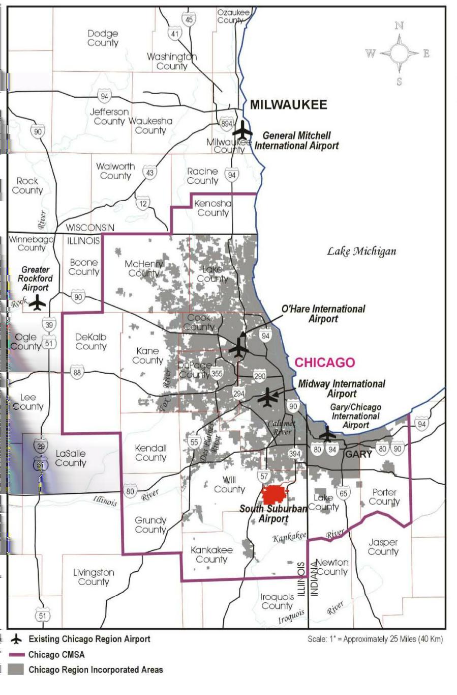
3 Section 1 Introduction The South Suburban Airport (SSA) is a new Greenfield airport in Will County, Illinois proposed by the Illinois Department of Transportation - Division of Aeronautics (IDOT). The eastern Will County site was approved as a feasible location for the proposed airport by the Federal Aviation Administration (FAA) in their Record of Decision (ROD) in the Tier I Environmental Impact Statement (Tier 1 EIS) for SSA, issued July The SSA site is mostly located in unincorporated Will County, within the greater Chicago region, which includes the northeast Illinois/northwest Indiana metropolitan area. Specifically, the greater Chicago region includes seven counties located in northeastern Illinois, which are Cook, DuPage, Kane, Kankakee, Lake, McHenry and Will counties; and two counties located in northwestern Indiana, which are Lake and Porter counties. According to the U.S. Census Bureau, the greater Chicago region is the third largest metropolitan area in the United States and approximately 8.8 million people resided in the nine county project areas in The land acquisition area for the SSA Ultimate Airport Boundary comprises approximately 20,000 acres in unincorporated eastern Will County, Illinois (see Exhibit 1-1: South Suburban Airport Site Location). The initial phase, referred hereafter as the Inaugural Airport Program (IAP), is located within the land acquisition area of the Ultimate Airport Boundary. The Village of Peotone lies to the southwest of the site, Monee to the northwest, University Park to the north, Crete to the northeast and Beecher to the southeast. The center of the site is approximately 35 miles south-southwest of the Chicago Central Business District (CCBD), 42 miles south-southeast of Chicago O'Hare International Airport and 29 miles south of Chicago Midway International Airport. The site is located east of Interstate 57 and Illinois Route 50 and west of Illinois Routes 1 and 394. The site is located in unincorporated Will County, mostly in the Townships of Will and Monee, with smaller portions located in Crete and Washington townships. The majority of the development associated with the IAP will occur within Will Township, with some related development in Monee and Washington townships. The established IAP boundary is refined as appropriate when new data and guidance becomes available throughout the course of the Master Plan. The previously established IAP Boundary is depicted in the Facility Requirements Report; Exhibit 1-3: IAP and Ultimate Airport Boundaries. Based on the Preliminary Access Justification Report (AJR), which incorporates input from IDOT - Division of Highways and the Federal Highway Administration (FHWA), the established IAP boundary has been revised. Additionally, a consistency review of the IAP boundary was completed to ensure continuity among the various facets of the SSA program. The IAP boundary has been adjusted to reconcile the results of that effort. All above modifications to the IAP boundary fall within the Ultimate Airport Boundary as identified in the Tier 1 EIS, the ROD and subsequent Master Plan reports. The resulting established IAP and ultimate airport boundaries used in the analysis of this report are depicted in Exhibit 1-2: IAP and Ultimate Boundaries. The purpose of this report is to document the development and the evaluation of several alternatives and the process used to select a preferred airfield alternative. The timeline for the IAP starts at Date of Beneficial Occupancy (DBO) and continues through the fifth year of operation (DBO+5). While the SSA Master Plan will focus on the IAP, it will also identify potential airport facilities beyond the IAP for Intermediate and Ultimate phases. Section 1 - Introduction Page 1
4 Page 2
5 Page 3
6 Section 2 - Principal Benefits The South Suburban Airport will: Satisfy the need to provide supplemental air transportation facilities to meet the existing and anticipated demands for air carrier, air cargo and general and corporate aviation use within the south suburban area of the greater Chicago region. Preserve the option of developing a future air carrier airport to serve the greater Chicago region as determined necessary and appropriate to meet future aviation capacity needs in the region. Provide market access for air carriers, increasing the opportunity for growth in one of the most rapidly developing areas in the country. The primary service area within 45 minutes of the airport is anticipated to include 2.3 million people by Provide air cargo handling facilities that would serve the freight forwarders, businesses, industrial and warehousing facilities presently located in the south and southwest suburbs of Chicago. Expand and improve existing General Aviation (GA) and corporate air services and provide access to portions of central and eastern Will County. Section 2 Principal Benefits Page 4
7 Section 3 - Background 3.1: Overview of Site Selection The FAA decided to use a tiered approach to the environmental documentation of SSA as proposed by the State of Illinois. The Tier 1 EIS reviewed the alternative analyses contained in the following studies: the Chicago Area Capacity Study, the Illinois Indiana Regional Airport Study, the Phased Development of a Greenfield Airport, the Joliet Arsenal Feasibility Study, the Phase 1 Engineering Study and evaluated six alternative sites identified by IDOT and a No-Build option to determine which alternatives were considered feasible, prudent and reasonable. The Tier 1 EIS analysis focused on operational and environmental considerations. As a result of this analysis, the No-Build, Kankakee and Will County sites were chosen for more detailed environmental evaluation. The Will County site was selected as the preferred site in the Tier 1 ROD and Kankakee site was eliminated from further consideration. The FAA s Tier 2-Environmental Impact Statement (Tier 2 EIS) will focus on the environmental impact of the proposed SSA Master Plan alternatives for the preferred Will County site. 3.2: Existing Conditions The purpose of this document is to describe the existing conditions of the proposed SSA site, as of May, 2010, that are affected or created by the IAP. Traditionally a portion of the chapter is devoted to identifying and documenting the physical facilities at the airport being studied. The SSA Master Plan, however, is being developed to define the needs of a facility that has not yet been constructed and is not currently in operation. Therefore, the data collected and presented focused on developing an understanding of the service area to ensure an accurate assessment of the air transportation needs. The Existing Conditions Report, August 31, 2011, presents a description of the existing airspace management system, the weather factors that affect flight, air carrier and GA facilities, the regional setting of the airport site, an environmental overview, (noise, air quality, water quality, floodplains, wetlands, endangered and threatened species of flora and fauna, biotic communities, park and recreation lands, cultural resources and farmlands), the regional socio-economic data and the SSA Land Acquisition Program. The greater Chicago region is the third largest metropolitan area in the United States and is highly diverse, with land uses ranging from farmland to heavy industry, major commercial centers and residential areas. Will County has realized a population increase of 25% thereby making it one of the largest numerical increases posted amongst the state s 102 counties. 1 The Chicago Metropolitan Area Agency for Planning (CMAP) projects that Will County s population will exceed 1.2+ million by the year : Aviation Forecasts In 2004, IDOT developed an initial forecast of aeronautical activity for SSA. The Projections of Aeronautical Activity for the Inaugural Airport Program, May 11, 2004 was approved by FAA on June 4, The forecasts addressed three separate facets of aeronautical activity including: air passenger, air cargo and GA/corporate aviation. In spring 2008, FAA requested IDOT conduct a validation of the prospective airport s feasibility due to changing conditions in the economy at that time. The updated forecasts of aeronautical activity confirmed population and employment trends and were presented in the Forecast 2009: Verification of 2004 Forecasts, May 14, 2010, approved by FAA March 23, : Facility Requirements IDOT used the Forecast 2009: Verification of 2004 Forecasts, May 14, 2010, approved by FAA March 23, 2011 to prepare the Facility Requirements Report, October 25, The IAP facility requirements include: a 9,500 ft. by 150 ft. Commercial Runway including a full parallel taxiway at a orientation, Air Traffic Control Tower (ATCT), Instrument Landing System (ILS) - CAT I on Runway End 27L, Passenger Terminal with Narrowbody and Regional Jet Gates, Air Cargo Aircraft Positions and Area, General Aviation/Corporate Aviation Area, Navigational and Visual Aids, Ancillary/Support Facilities (Fuel Storage, Snow Removal Equipment Complex (SRE), Airport Rescue and Fire Fighting (ARFF)) and I-57 Interchange with a dedicated airport access road. The IAP forecast activity was extrapolated to derive a projection of SSA activity for the purpose of developing facility requirements for the 1 Illinois Census, Chicago Metropolitan Agency for Planning, Section 3 - Background Page 5
8 Intermediate and Ultimate planning horizons. This approach allows for flexible airport planning and improvements to occur as needed in the future. Airfield development items identified in the Facility Requirements Report, October 25, 2011, were approved by FAA on November 10, 2011 and utilized as the foundation of the development and analysis of SSA alternatives. Section 3 - Background Page 6
9 Section 4 - Alternatives Development/Identification 4.1: Introduction This section starts with a review of public involvement actions that have taken place in defining alternative airfield development. This section continues with an overview of previous alternative analyses that have been conducted including: South Suburban Airport Phase I Engineering Report, 1998; the FAA s Tier 1 EIS-ROD issued July 2002, Concept Alternatives Analysis dated September 21, 2005; IDOT and Abraham Lincoln National Airport Commission (ALNAC) plans dated December 19, 2006; and the development of IDOT s Preferred Inaugural Airport Configuration, March 7, This section concludes with a discussion on unique planning considerations and the description of final alternative airport plans. 4.2: Public Involvement Discussion FAA Advisory Circular AC 150/5070-6B, Airport Master Plans, Chapter 4 Public Involvement Program, provides general and specific guidance for the development of a public involvement program in support of the airport master planning process. Tools and techniques an airport sponsor might use in the public involvement process includes: advisory committees, public information meetings, small group meetings and briefings and public awareness campaigns. IDOT employed all of these in the feasibility, site selection and alternatives development phases of SSA planning. The FAA Tier 1 EIS documents the project s public involvement processes through the approval of the Will County site for a potential future supplemental air carrier airport to serve the greater Chicago region. With the completion of the Tier 1 EIS and commencement of land acquisition, IDOT developed a project website to provide the public with easier access to project information and documents related to the SSA Master Plan, environmental and land acquisition activities. The SSA Master Plan process included refinement and further study of alternatives as approved in the FAA Tier 1 EIS. IDOT conducted meetings with local officials and the public in late 2002 and the FAA solicited public input through the SSA Tier 2 EIS scoping process. The results of the 2003 scoping process are available in the environmental section of the project website. In 2004, IDOT conducted a series of public advisory meetings that concluded with a planning workshop, at Governors State University and utilized anonymous electronic polling to collect survey data regarding identified issues for the SSA Master Plan. During late 2004 through 2006, IDOT worked with the FAA, United States Army Corps of Engineers, United States Environmental Protection Agency, Illinois Department of Natural Resources and the Illinois Environmental Protection Agency to develop an alternative IAP layout to minimize environmental impacts, especially, impacts to Black Walnut Creek. Through this period, meetings were conducted with local stakeholders including local village presidents and administrators, county officials, state and Federal legislators and business leaders. In December 2006, IDOT presented two revised airfield concepts to the general public for discussion and input at a public information workshop at Beecher High School. The first was the IDOT IAP and the second was the ALNAC IAP. Both plans incorporated airfield changes that would diminish the impacts to Black Walnut Creek and address the environmental concerns raised by the Federal agencies. These plans also reflected the airfield improvements undertaken at Bult Field (C56) since the release of the Preferred IAP Concept in The purpose of the public workshop was to inform the public about the SSA planning process and to receive comments regarding alternative airport plans developed by IDOT and ALNAC. This large-scale public meeting included presentations by government officials. Comments were submitted verbally and in writing by the public. Through 2007 and early 2008, IDOT continued to develop and analyze IAP layouts. Meetings with local, state and Federal officials continued up through submittal to the FAA of IDOT s draft Selection of IDOT Preferred Inaugural Airport Configuration, dated March 7, In June 2010, IDOT updated the SSA website to make it more accessible and intuitive to the public. Briefings on the SSA Master Plan to Federal, state and local agencies and the Section 4 - Alternatives Development/Identification Page 7
10 general public, are ongoing and will be conducted as necessary to keep stakeholders apprised of project updates and activities. 4.3: Previous Alternative Identification FAA Tier I EIS - April 2002 At the request of the State of Illinois, the FAA prepared the first tier of a tiered EIS to assess impacts relative to FAA site approval and the associated land acquisition by the State for a potential future supplemental air carrier airport to serve the greater Chicago region. The Tier 1 EIS ROD, issued July 2002, considered the site-specific planning, construction, funding and operation of a new supplemental air carrier airport. The ROD provided final agency determinations and approvals for Federal actions by the FAA related to the selection of the Will County site and the elimination of Kankakee as the site for SSA. These actions were necessary to preserve the option of developing an air carrier airport to serve the greater Chicago region as determined necessary and appropriate to meet future aviation capacity needs in the region. Site approval has allowed the State to acquire and preserve land for airport purposes consistent with FAA environmental policy. FAA s site approval was based upon the continuing need to protect the airspace and preserve a technically and environmentally feasible site from encroachment from suburban development and provide for continued protection of the airspace. The airport site, known in the Tier I EIS as the Will County site, is located approximately 35 miles south of the CCBD Draft Concept Alternatives Analysis for the IAP, September 21, 2005 The process utilized by IDOT for the identification, evaluation and selection of alternatives is the process described in Section 902 of FAA AC 150/5070-6B, Airport Master Plans. The concept alternatives for the IAP studied in the Draft Concept Alternatives Analysis for the IAP, September 21, 2005 were developed based on input from various stakeholders. Based on the FAA approved Projections of Aeronautical Activity for the Inaugural Airport Program, May 11, 2004, concept alternatives were developed for each of the major airport elements, including, runways, passenger terminal, airport access, airport support and ancillary facilities. Specific criteria were developed to evaluate and rate each of these facilities. A level of priority was given to each airport facility with the highest primacy given to the commercial runway facility followed by the GA runway, landside access and passenger terminal. Air cargo, GA facilities and airport support facilities were added to the previously selected airfield concepts to create the preferred IAP concept. The Draft Concept Alternatives Analysis for the IAP, September 21, 2005 report included the best rated alternative for each of these facilities. A sensitivity analysis was then conducted to determine whether the preferred concept is truly the best overall IAP concept when compared to other logical concepts Selection of IDOT Preferred IAP Configuration - Preliminary Draft dated March 7, 2008 The Concept Alternatives Analysis for the IAP was submitted to the FAA for review on September 21, Subsequently, IDOT revised the concepts in the report to address the concerns raised by Federal agencies regarding the magnitude of the environmental impacts incurred by the preferred concept to Black Walnut Creek. In December 2006, IDOT presented two revised airfield concepts to the general public for discussion and input. Both plans incorporated airfield changes that would diminish potential impacts to Black Walnut Creek and address environmental concerns raised by the Federal agencies. The revised plans also reflected airfield improvements undertaken and completed at C56 at the time of the release of the Draft Concept Alternatives Analysis for the IAP, September 21, In early 2007, both revised airfield concepts were submitted to FAA for review. FAA declined to review the two concepts and returned the plans to IDOT for further consideration and refinement and recommended that only one preferred plan be resubmitted. In light of this guidance IDOT re-examined all alternatives with a goal of optimizing the airfield configuration. 3 Concept Alternatives Analysis for the Inaugural Airport Program South Suburban Airport, September 21, 2005, prepared by AECOM, formerly TAMS, an Earth Tech Company, for the Illinois Department of Transportation. Section 4 - Alternatives Development/Identification Page 8
11 In January 2008, IDOT undertook the evaluation of additional concept alternatives for the IAP. Initially, five alternative runway centerline locations were identified. Subsequently, based upon input from the FAA Great Lakes Airport District Office, an additional potential runway location was identified using the C56 runway centerline as the commercial runway centerline. Upon conclusion of this runway centerline analysis, an IDOT preferred alternative was identified and became the basis for the preparation of a preliminary airport layout plan : Final Alternatives Identification Alternatives were developed in accordance with the previously approved SSA Master Plan chapters: Forecasts 2009: Verification of 2004 Forecasts, May 14, 2010, approved by FAA March 23, 2011 and the Facility Requirements Report, October 25, 2011, approved by FAA on November 10, The IAP facility requirements include the following components that are consistent among all of the alternatives: a 9,500 ft. by 150 ft. Commercial Runway including a full parallel taxiway at a orientation, ATCT, ILS - CAT I on Runway End 27L, Passenger Terminal with Narrowbody and Regional Jet Gates, Air Cargo Aircraft Positions and Area, General Aviation/Corporate Aviation Area, Navigational and Visual Aids, Ancillary/Support Facilities SRE, ARFF and I-57 Interchange with a dedicated airport access road. Alternative airport plans developed for each centerline are analyzed below and depicted in Exhibit 4-1: Six Alternative Commercial Runway Centerlines Alternative 1 - The runway alignment that resulted from the Draft Concept Alternatives Analysis for the IAP, September 21, 2005, was retained as Alternative 1. This alternative is illustrated in Exhibit 4-2: IAP Concept - Alternative 1. The airfield includes a 9,500 ft. long instrument runway in a orientation. The horizontal separation between the IAP runway and the runway at C56 is approximately 3,700 ft. Runway End 27L and Runway End 27R are staggered approximately 2,000 ft. Major airside facilities (runway and taxiway) would be located south of Eagle Lake Road. All other support facilities (passenger terminal, cargo, ATCT and ancillary facilities) would be located north of Eagle Lake Road. The terminal complex is located to the north and approximately 2,100 ft. east of the Runway End 09R of the IAP runway within a terminal zone sized to accommodate the landside roadway loop, terminal curb-front and parking facilities along with the airside aircraft parking apron. Direct access to/from I-57 is provided via a new interchange and access road connecting I-57 to the terminal. The horizontal alignment of the access road minimizes crossings of Black Walnut Creek. Secondary access will be provided from local roads. Cargo facilities are located north of the primary runway threshold with access from improved Eagle Lake Road. The existing GA/corporate runway at C56 is expected to serve the GA/corporate needs at SSA and would be connected to the primary runway by a taxiway approximately 3,700 ft. long. Access to the GA/corporate area will be provided from Offner Road via a relocated Kedzie Avenue. The proposed facilities are located within the established IAP boundary, requiring no additional land acquisition. The land between the IAP Air Operations Area (AOA) and C56 would continue to be utilized for agricultural use until it is needed for aviation purposes. The AOA 5 is any area of an airport used or intended to be used for landing, takeoff or surface maneuvering of aircraft. An AOA includes such paved areas or unpaved areas that are used or intended to be used for the unobstructed movement of aircraft in addition to its associated runway, taxiways, or aprons Alternative 2 - This alternative was introduced in 2006 after ALNAC requested a separation of 6,100 ft. from the existing C56 runway. This alternative is illustrated in Exhibit 4-3: IAP Concept - Alternative 2. This alternative would require additional land acquisition outside the established IAP boundary to contain airport related noise. The airfield includes a 9,500 ft. long instrument runway in a orientation. The resulting horizontal separation between the IAP runway and the runway at C56 is approximately 6,100 ft. Runway End 27L and Runway End 27R are staggered approximately 2,000 ft. 4 Selection of IDOT Preferred Inaugural Airport Configuration Report, prepared by AECOM, formerly Earth Tech, for the Illinois Department of Transportation, March 7, Federal Aviation Administration Advisory Circular 150/ B, Hazardous Wildlife Attractants on or Near Airports. Section 4 - Alternatives Development/Identification Page 9
12 e Hwy.) Racine Avenue Crawford Kedzie Western Ridgeland Avenue Harlem Avenue Egyptian Trail Will Center Road New Ashland Ave Knacke Road Ridgeland Avenue Highland Avenue Harvest Lane Calumet Exp Ohlendorf Road Arlington Lane Pauling Road Drecksler Road Goodenow Road Goodenow Kuersten Rd Crawford Ave Kedzie Ave Offner Road Offner Road Eagle Lake Road Eagle Lake Eagle Lake Road Canadian National/Illinois Central Railroad Black Will Center Road North Peotone Road Ashland Avenue Church Road Peotone Beecher Road Illinois Department of Transportation Division of Aeronautics 1"=3000' June 6, 2012 SIX ALTERNATIVE COMMERCIAL RUNWAY CENTERLINES SSA MASTER PLAN ALTERNATIVES DEVELOPMENT AND EVALUATION Exhibit 4 1 Page 10
13 Racine Avenue Crawford Kedzie Western Ridgeland Avenue Egyptian Trail Ashland Ave Will Center Road Knacke Road Ridgeland Avenue Highland Avenue New Harvest Lane Ohlendorf Road Arlington Lane Pauling Road Drecksler Road Goodenow Road Goodenow Kuersten Rd Crawford Ave Kedzie Ave Offner Road Offner Road Harlem Avenue Initial Air Cargo ATCT GA Facilities Fuel Farm ARFF Eagle Lake Road Eagle Lake Eagle Lake Road SRE 3,700' Air Cargo Expansion Canadian National/Illinois Central Railroad Will Center Road North Peotone Road Ashland Avenue Church Road Peotone Beecher Road Illinois Department of Transportation Division of Aeronautics 1"=3000' June 6, 2012 IAP CONCEPT ALTERNATIVE 1 SSA MASTER PLAN ALTERNATIVES DEVELOPMENT AND EVALUATION Exhibit 4 2 Page 11
14 IL. Route 50 I 57 Illinois Department of Transportation Division of Aeronautics 1"=3000' June 6, 2012 IAP CONCEPT ALTERNATIVE 2 SSA MASTER PLAN ALTERNATIVES DEVELOPMENT AND EVALUATION Exhibit 4 3 Page 12
15 All aeronautical and support facilities (runway, taxiways, service roads, passenger terminal, cargo, ATCT and ancillary facilities) would be located south of Eagle Lake Road with the runway located outside the established IAP boundary. The location of airside aeronautical facilities and support facilities to the IAP runway is consistent with Alternative 1. The terminal complex is located to the north and approximately 2,100 ft. east of Runway End 9R of the IAP runway within a terminal zone sized to accommodate the landside roadway loop, terminal curb-front, parking facilities and the airside aircraft parking apron. Direct access to/from I-57 is provided via a new interchange and access road connecting I-57 to the terminal. The horizontal alignment of the access road minimizes crossings of Black Walnut Creek. Secondary access will be provided from local roads. Cargo facilities are located off the east end of the primary runway and to the north with access from improved Western Avenue and improved Eagle Lake Road. The existing GA/corporate runway at C56 is expected to serve the GA/corporate needs at SSA and would be connected to the primary runway by a taxiway approximately 6,100 ft. long. Access to the GA/corporate area will be provided from Offner Road via a relocated Kedzie Avenue. The proposed commercial runway is located outside the established IAP boundary. Therefore, Alternative 2 will require approximately 1,600 acres of additional land acquisition. The land between the IAP, the AOA and C56 would continue to be utilized for agricultural use until it is needed for aviation purposes Alternative 3 - This alternative was introduced in 2007 after ALNAC requested a northern shift of 1,100 ft. to their 2006 alignment. This alternative is illustrated in Exhibit 4-4: IAP Concept - Alternative 3. This alternative would require additional land acquisition outside the established IAP boundary to contain airport related noise. The airfield includes a 9,500 ft. long instrument runway in a orientation. The resulting horizontal separation between the IAP runway and the runway at C56 is approximately 5,000 ft. Runway End 27L and Runway End 27R are staggered approximately 2,000 ft. All aeronautical and support facilities (runway, taxiways, service roads, passenger terminal, cargo, air traffic control tower and ancillary facilities) would be located just north of North Peotone Road. The location of airside aeronautical facilities and support facilities to the IAP runway is consistent with Alternative 1. The terminal complex is located to the north and approximately 2,100 ft. east of Runway End 09R of the IAP runway within a terminal zone sized to accommodate the landside roadway loop, terminal curb-front, parking facilities and the airside aircraft parking apron. Direct access to/from I-57 is provided via a new interchange and access road connecting I-57 to the terminal. The horizontal alignment of the access road minimizes crossings of Black Walnut Creek. Secondary access will be provided from local roads. Cargo facilities are located off the east end of the primary runway and to the north with access from improved Eagle Lake Road. The existing GA/corporate runway at C56 is expected to serve the GA/corporate needs at SSA and would be connected to the primary runway by a taxiway approximately 5,000 ft. long. Access to the GA/corporate area will be provided from Offner Road via a relocated Kedzie Avenue. The proposed facilities are located within the established IAP boundary. A small portion of the 65DNL contour falls outside the IAP boundary. To ensure future compatible land use within the 65DNL, consideration may be given to future land acquisition (1,600 acres). The land between the IAP, the AOA and C56 would continue to be utilized for agricultural use until it is needed for aviation purposes Alternative 4 - The preferred runway alignment that resulted from the Selection of IDOT Preferred IAP Configuration, Preliminary Draft, March 7, 2008 was retained as Alternative 4. This alternative is illustrated in Exhibit 4-5: IAP Concept - Alternative 4. This alternative proposes to locate the IAP runway approximately 600 ft. south of the runway location proposed in Alternative 1. The airfield includes a 9,500 ft. long instrument runway in a orientation. The resulting horizontal separation between the IAP runway and the runway at C56 is approximately 4,300 ft. The Runway End 27L and Runway End 27R are staggered approximately 2,000 ft. Section 4 - Alternatives Development/Identification Page 13

16 Egyptian Trail Walnut Will Center Road Crawford Avenue Kedzie Avenue Western Avenue Ashland Avenue Racine Avenue Harlem Avenue Egyptian Tr. Kuersten Road Kedzie Avenue Knacke Road Drecksler Road Ridgeland Avenue Highland Avenue Harvest Lane Ohlendorf Road Arlington Lane Pauling Road New Goodenow Road Goodenow Offner Road Offner Road Ashland Avenue GA Facilities Ridgeland Avenue Eagle Lake Road Eagle Lake Road Creek Airport Access Road Initial Air Cargo ARFF ATCT Airfield Electric 5,000' SRE Fuel Farm Air Cargo Expansion Eagle Lake Road Canadian National/Illinois Central Railroad Black North Peotone Road Church Road Peotone Beecher Road Illinois Department of Transportation Division of Aeronautics 1"=3000' June 6, 2012 IAP CONCEPT ALTERNATIVE 3 SSA MASTER PLAN ALTERNATIVES DEVELOPMENT AND EVALUATION Exhibit 4 4 Page 14
17 Racine Avenue Crawford Kedzie Western Ridgeland Avenue Harlem Avenue Egyptian Trail Ashland Ave Will Center Road Knacke Road Ridgeland Avenue Highland Avenue New Harvest Lane Ohlendorf Road Arlington Lane Pauling Road Drecksler Road Goodenow Road Goodenow Kuersten Rd Crawford Ave Kedzie Ave Offner Road Offner Road Eagle Lake Road Eagle Lake Eagle Lake Road 4,300' Canadian National/Illinois Central Railroad Will Center Road Runway 9R 27L 9,500' x 150' North Peotone Road Ashland Avenue Church Road Peotone Beecher Road Illinois Department of Transportation Division of Aeronautics 1"=3000' June 6, 2012 IAP CONCEPT ALTERNATIVE 4 SSA MASTER PLAN ALTERNATIVES DEVELOPMENT AND EVALUATION Exhibit 4 5 Page 15
18 Major airside facilities (runway and taxiway) would be located south of Eagle Lake Road. All other support facilities (passenger terminal, cargo, ATCT and ancillary facilities) would be located north of Eagle Lake Road. The location of airside aeronautical facilities and support facilities to the IAP runway is consistent with Alternative 1. The terminal complex is located to the north and approximately 2,100 ft. east of Runway End 09R of the IAP runway within a terminal zone sized to accommodate the landside roadway loop, terminal curb-front, parking facilities and the airside aircraft parking apron. Direct access to/from I-57 is provided via a new interchange and access road connecting I-57 to the terminal. The horizontal alignment of the access road minimizes crossings of Black Walnut Creek. Secondary access will be provided from local roads. Cargo facilities are located off the east end of the primary runway and to the north with access from improved Eagle Lake Road. The existing GA/corporate runway at C56 is expected to serve the GA/corporate needs at SSA and would be connected to the primary runway by a taxiway approximately 4,300 ft. long. Access to the GA/corporate area will be provided from Offner Road via a relocated Kedzie Avenue. The proposed facilities are located within the established IAP boundary. The noise/safety areas are located outside the established IAP boundary. Therefore, Alternative 4 may require approximately 227 acres of additional land acquisition. The land between the IAP, the AOA and C56 would continue to be utilized for agricultural use until it is needed for aviation purposes Alternative 5 - This alternative was originally proposed in Selection of IDOT Preferred IAP Configuration, Preliminary Draft dated March 7, 2008 and was retained as Alternative 5. This alternative is illustrated in Exhibit 4-6: IAP Concept - Alternative 5. This alternative represents the southern-most location that the IAP runway could be shifted such that all elements associated with the runway, including safety areas and NAVAID critical areas, would remain within the established IAP boundary. The airfield includes a 9,500 ft. long instrument runway in a orientation. The resulting horizontal separation between the IAP runway and the runway at C56 is approximately 4,600 ft. Runway End 27L and Runway End 27R are staggered approximately 2,000 ft. Major airside facilities (runway and taxiway) would be located south of Eagle Lake Road. All other support facilities (passenger terminal, cargo, ATCT and ancillary facilities) would be located along north of Eagle Lake Road. The location of airside aeronautical facilities and support facilities to the IAP runway is consistent with Alternative 1: The terminal complex is located to the north and approximately 2,100 ft. east of the Runway End 09R of the IAP runway within a terminal zone sized to accommodate the landside roadway loop, terminal curb-front, parking facilities and the airside aircraft parking apron. Direct access to/from I-57 is provided via a new interchange and access road connecting I-57 to the terminal. The horizontal alignment of the access road minimizes crossings of Black Walnut Creek. Secondary access will be provided from local roads. Cargo facilities are located off the east end of the primary runway and to the north with access from improved Eagle Lake Road. The existing GA/corporate runway at C56 is expected to serve the GA/corporate needs at SSA and would be connected to the primary runway by a taxiway approximately 4,600 ft. long. Access to the GA/corporate area will be provided from Offner Road via a relocated Kedzie Avenue. The proposed facilities are located within the established IAP boundary. A small portion of the 65DNL contour falls outside the IAP boundary. To ensure future compatible land use within the 65DNL, consideration may be given to future land acquisition (623 acres). The land between the IAP, the AOA and C56 would continue to be utilized for agricultural use until it is needed for aviation purposes Alternative 6 - This alternative uses the C56 runway centerline as the commercial runway centerline and was developed as a result of input from the FAA Great Lakes Airport District Office after their review of Selection of IDOT Preferred IAP Configuration, Preliminary Draft, March 7, The C56 runway and its facilities were constructed to state standards for privately-owned, open to the public airports and not to FAA standards. IDOT Section 4 - Alternatives Development/Identification Page 16
19 IL. Route 50 I 57 4,600' Illinois Department of Transportation Division of Aeronautics 1"=3000' June 6, 2012 IAP CONCEPT ALTERNATIVE 5 SSA MASTER PLAN ALTERNATIVES DEVELOPMENT AND EVALUATION Exhibit 4 6 Page 17
20 has determined that the existing GA/corporate facility has the capacity to adequately accommodate GA/corporate aircraft, however it is not currently suitable for commercial operations. Alternative 6 represents the commercial service improvements necessary to meet FAA standards and include the following: Runway Length - The 5,000 ft. runway length does not meet the 9,500 ft. requirements of the critical aircraft as set forth in the Forecast 2009: Verification of 2004 Forecasts and the Facility Requirements Report. This existing runway length is insufficient for commercial passenger aircraft (Boeing B737 and A320) and cargo aircraft (B F, B F and the A F) that are anticipated to operate at SSA. Runway Width - The runway width does not meet the requirements of the critical aircraft that will be in operation at SSA. The existing GA/corporate runway is 75 ft. in width. The B737 and A320 are Airplane Design Group III aircraft which require a runway width of 100 ft. The B F and A F are Airplane Design Group IV aircraft which require a runway width of 150 ft. Runway Strength - The weight bearing capacity does not meet the requirements of the critical aircraft that will be in operation at SSA. The existing GA/corporate runway is 60,000 lbs. single wheel, which is insufficient for the commercial passenger aircraft and cargo aircraft (174,200 lbs.) anticipated to operate at SSA. Runway/Taxiway Separation - The runway centerline to taxiway centerline separation and the taxiway to fixed or moveable object clearances of the GA/corporate runway do not meet the requirements of the commercial critical aircraft that will be in operation at SSA. It would be necessary to extensively reconfigure the airfield and demolish or move the existing aircraft hangars and Fixed Base Operator (FBO) office to comply with runway/taxiway separation standards. Alternative 6 is illustrated in Exhibit 4-7: IAP Concept - Alternative 6. The airfield includes a 9,500 ft. long instrument runway in a orientation. The Runway End 27 has been relocated approximately 2,000 ft. to the west to remain consistent with the east/west location of the other commercial service runway alternatives. All aeronautical and support facilities (runway, taxiways, service roads, passenger terminal, cargo, ATCT and ancillary facilities) would be located between Eagle Lake Road and Offner Road. Because this runway alignment is north of the Ultimate airfield centerline, this runway would become the northern inboard runway. Therefore, in contrast to the other alternatives, the terminal core is located south of the Inaugural runway. The location of airside aeronautical facilities is essentially a mirroring of those presented in Alternative 1, with the exception of a relocated GA area. The terminal complex is located to the south and approximately 2,100 ft. east of the Runway End 09 of the IAP runway within a terminal zone sized to accommodate the landside roadway loop, terminal curbfront, parking facilities and the airside aircraft parking apron. Direct access to/from I-57 is provided via a new interchange and access road connecting I-57 to the terminal. The horizontal alignment of the access road minimizes crossings of Black Walnut Creek. Secondary access will be provided from local roads. Cargo facilities are located off the east end of the runway and to the south with access from improved Eagle Lake Road. The existing GA/corporate facilities (hangars, FBO, apron, fuel, etc.) would be relocated south of the current location to meet safety/setback requirements. Access to the GA/corporate area will be provided from improved Eagle Lake Road. The proposed commercial runway is located partially outside the established IAP boundary. Therefore, Alternative 6 will require approximately 620 acres of additional land acquisition. Land outside the AOA would continue to be utilized for agricultural use until it is needed for aviation purposes. Section 4 - Alternatives Development/Identification Page 18
21 Egyptian Trail Ashland Avenue Racine Avenue Ridgeland Avenue Will Center Road Knacke Road Drecksler Road Ridgeland Avenue Highland Avenue Harvest Lane Ohlendorf Road Arlington Lane Pauling Road New Goodenow Road Goodenow Offner Road Offner Road Ashland Avenue Egyptian Tr. AOA Security Fence Airfield Service Road Runway 9R 27L 9,500'x150' Harlem Avenue Estimated 65 DNL Contour Airport Access Road Crawford Avenue ADMIN FBO Eagle Lake Road Eagle Lake Road Kedzie Avenue Air Cargo Expansion Eagle Lake Road Canadian National/Illinois Central Railroad IAP BOUNDARY Western Avenue North Peotone Road Church Road Peotone Beecher Road Illinois Department of Transportation Division of Aeronautics 1"=3000' June 6, 2012 IAP CONCEPT ALTERNATIVE 6 SSA MASTER PLAN ALTERNATIVES DEVELOPMENT AND EVALUATION Exhibit 4 7 Page 19
22 Section 5 - Evaluation of Alternatives 5.1: Evaluation Criteria The IAP facility was approved as a feasible location for the proposed airport by the FAA in their ROD in the Tier 1 EIS for SSA, issued July The IAP facility requirements include: a 9,500 ft. by 150 ft. Commercial Runway including a full parallel taxiway at a orientation, ATCT, ILS - CAT I on Runway End 27L, Passenger Terminal with Narrowbody and Regional Jet Gates, Air Cargo Aircraft Positions and Area, GA/Corporate Aviation Area, NAVAIDS, Ancillary/Support Facilities, SRE, ARFF and I-57 Interchange with a dedicated airport access road. The IAP airfield alternatives were examined and evaluated based on a set of criteria that were selected by IDOT. These criteria are listed and defined in Table 5-1: IAP Airport Concept Alternatives Evaluation Criteria. A short description of how each evaluation criteria was used to evaluate the alternatives is provided below. Table 5-1: IAP Airport Concept Alternatives Evaluation Criteria Evaluation Criteria Ability to Maximize Airfield Operational Efficiency - DBO+5 Compatibility with Preferred Ultimate Airfield Concept Airport Security Ability to Avoid and/or Minimize Land Use Impacts Ability to Avoid and/or Minimize Natural Resource Impacts Potential to Minimize Costs Definition Minimize aircraft taxiing distances Provide adequate runway separation to allow unconstrained expansion of the terminal complex and landside facilities Provide adequate runway separation to permit independent instrument approaches to both runways The IAP runway should be compatible with the preferred Ultimate airfield concept o Accommodate four simultaneous precision instrument approaches o Provide for perimeter taxiways to avoid/minimize runway crossings o Provide adequate separation between inner parallel runway to allow for all potential terminal complex expansion needs The IAP airport should be able to meet security requirements efficiently (minimum airport perimeter length, minimum perimeter security zone) Develop an IAP airfield concept that would minimize conflicts with the land use plans of the neighboring communities Contain all significant aircraft-generated noise, as defined by FAA, on airport property or compatible land uses Minimizes area of land needed for the airport s landside and airside operations Minimum population displacement Minimum disruption to local roads Impacts to wetlands Impacts to floodplains Impacts to water resources Impacts to prime farmland Compare relative costs of each IAP runway concept for additional land acquisition and relocation of existing aviation facilities Utilities (electrical, natural gas, water, sewer, etc.), access to the airport via the local road network and emergency vehicle and school bus routing were considered for inclusion as evaluation criteria. A preliminary analysis of these items determined that the relative difference amongst all six alternatives was negligible. Therefore, these development items were not included as final evaluation criteria. Evaluation Criterion 1 - Ability to Maximize Airfield Operational Efficiency DBO+5 Each IAP airfield alternative must be capable of accommodating the level of operations forecasted for DBO+5. 6 In addition, an airfield concept that would allow for adequate runway separation for at least dual independent instrument arrivals was considered preferable to those which did not meet this criterion. Adequate area should be 6 Draft Projections of Aeronautical Activity for the Inaugural Airport Program, South Suburban Airport, prepared for the Illinois Department of Transportation, May Section 5 Evaluation of Alternatives Page 20
23 provided for the passenger terminal and cargo facilities to expand and serve the needs of a second commercial runway. Evaluation Criterion 2 - Compatibility with Preferred Ultimate Airfield Concept This criterion examines whether an alternative is compatible with the selected preferred Ultimate airfield concept. If it was compatible, it received a positive (yes) designation; if the alternative was not compatible, it received a negative (no) designation. Evaluation Criterion 3 - Airport Security This criterion examined the airport perimeter to determine whether an alternative would have more or less area to secure. Those alternatives that were more compact were considered preferable to those alternatives that required a larger perimeter. In addition the ability of the configuration to provide a security buffer zone outside of the AOA fence was evaluated. Those alternatives that provided 1,200 ft. depth from runway centerline to AOA fence were considered preferable. The 1,200 ft. AOA depth from runway and parallel taxiway centerlines was recommended by airport security consultants. Evaluation Criterion 4 - Ability to Avoid and/or Minimize Land Use Impacts This criterion was divided into five sub-criteria to rate different impacts that are of concern to the landowners and communities surrounding the site. Sub-Criterion 4a - Conflicts with Local Land Use Plans - Each alternative was evaluated against the Will County, Illinois Land Resource Management Plan-Airport Environs Elements, dated January 2011, to determine if the alternative would conflict with the plan. Conflicts were defined as commercial airport facilities and/or safety areas located outside of the area shown for Inaugural airport development in the Will County plan; or on land planned for other uses by the communities within the Ultimate Airport Boundary; or if the IAP runway would be located directly east or west of planned residential land uses. Sub-Criterion 4b - Contain Aircraft Noise on Airport Property - Those alternatives that contain all significant aircraft-generated noise (as defined by FAA) on airport property were considered preferable to those that did not contain all aircraft-generated noise on airport property. Those that would result in 65 Day-Night Noise Level (DNL) noise contours over compatible land uses (as defined by FAA FAR Part 150) were considered less preferable. Other alternatives that result in 65 DNL noise contours over land outside the Ultimate Airport Boundary and on other land uses were considered least preferable. Sub-Criterion 4c - Optimal Land Area - Alternatives that would result in less land required for airport purposes were considered preferable to those that would require more land. Sub-Criterion 4d - Additional Land Acquisition - Alternatives that could be configured within the IAP site as determined in the Tier I ROD were considered preferable to those that required additional land beyond the IAP site. Sub-Criterion 4e - Population Displacement - Alternatives that minimize impacts to homes and residents were considered preferable to those that had greater impacts. Evaluation Criterion 5 - Ability to Avoid and/or Minimize Natural Resource Impacts This criterion was divided into four sub-criteria to rate different impacts that are of concern to the Federal and state natural resource agencies, special interest groups and the general public. Sub-Criterion 5a - Impacts to Wetlands - Alternatives that would result in fewer impacts to wetlands were considered preferable to those alternatives with greater impacts to wetlands. Sub-Criterion 5b - Impacts to Floodplains - Alternatives that would result in fewer impacts to floodplains were considered preferable to those alternatives with greater impacts to floodplains. Sub-Criterion 5c - Impacts to Water Resources - Alternatives that would result in fewer impacts to water resources (streams, lakes, etc.) were considered preferable to those alternatives with greater impacts to water resources. Section 5 Evaluation of Alternatives Page 21
Alternatives Development and Evaluation Report
 Airport Master Plan Alternatives Development and Evaluation Report Prepared by: AECOM Prepared for: Illinois Department of Transportation December 16, 2011 Table of Contents Topic Page Number Cover Sheet...
Draft Concept Alternatives Analysis for the Inaugural Airport Program September 2005
 Draft Concept Alternatives Analysis for the Inaugural Airport Program September 2005 Section 3 - Refinement of the Ultimate Airfield Concept Using the Base Concept identified in Section 2, IDOT re-examined
Draft Concept Alternatives Analysis for the Inaugural Airport Program September 2005
 Section 10 Preferred Inaugural Airport Concept 10.0 Introduction The Preferred Inaugural Airport Concept for SSA was developed by adding the preferred support/ancillary facilities selected in Section 9
Draft Concept Alternatives Analysis for the Inaugural Airport Program September 2005
 Draft Concept Alternatives Analysis for the Inaugural Airport Program September 2005 Section 1 - Introduction This report describes the development and analysis of concept alternatives that would accommodate
DRAFT FINAL REPORT AIRPORT MASTER PLAN. Rifle Garfield County Airport Revised May 15, 2014
 DRAFT FINAL REPORT AIRPORT MASTER PLAN Rifle Garfield County Airport Revised May 15, 2014 As required by Paragraph 425.B(4) of FAA Order 5100.38C, Airport Improvement Program (AIP) Handbook: The preparation
Lake Tahoe Airport Master Plan
 Lake Tahoe Airport Master Plan City Council Briefing October 20, 2015 What is an Airport Master Plan? a comprehensive study of an airport [that] usually describes the short, medium, and long term development
Lake Tahoe Airport Master Plan Public Meeting March 16, 2015
 Lake Tahoe Airport Master Plan Public Meeting March 16, 2015 What is an Airport Master Plan? a comprehensive study of an airport [that] usually describes the short, medium, and long term development plans
Executive Summary. MASTER PLAN UPDATE Fort Collins-Loveland Municipal Airport
 Executive Summary MASTER PLAN UPDATE Fort Collins-Loveland Municipal Airport As a general aviation and commercial service airport, Fort Collins- Loveland Municipal Airport serves as an important niche
CHAPTER 1 EXECUTIVE SUMMARY
 CHAPTER 1 EXECUTIVE SUMMARY 1 1 EXECUTIVE SUMMARY INTRODUCTION William R. Fairchild International Airport (CLM) is located approximately three miles west of the city of Port Angeles, Washington. The airport
Merritt Island Airport
 TABLE OF CONTENTS CHAPTER 1 INTRODUCTION... 1-1 INTRODUCTION AND PROJECT OVERVIEW... 1-1 General Guidelines... 1-1 Prior Planning Documentation... 1-2 Key Issues... 1-2 Goals and Objectives... 1-2 Regulatory
Appendix D Project Newsletters. Tacoma Narrows Airport. Master Plan Update
 Appendix D Project Newsletters Tacoma Narrows Airport Master Plan Update This appendix contains the newsletters distributed throughout the project. These newsletters provided updates and information on
Table of Contents. Master Plan March 2014 TOC i Spokane International Airport
 Table of Contents Page Chapter 1 Inventory 1. Introduction... 1 1 1.1 Community Profile... 1 2 1.1.1 Location and Setting... 1 1 1.1.2 Climate... 1 2 1.1.3 Socioeconomic Conditions... 1 5 1.1.4 Area Land
1.0 Project Background Mission Statement and Goals Objectives of this Sustainable Master Plan
 TABLE OF CONTENTS CHAPTER 1 INTRODUCTION 10 Project Background 1-1 11 Mission Statement and Goals 1-1 12 Objectives of this Sustainable Master Plan 1-2 CHAPTER 2 INVENTORY 20 Airport Background 2-1 201
Table of Contents. Overview Objectives Key Issues Process...1-3
 Table of Contents Chapter One Introduction Overview...1-1 Objectives...1-1 Key Issues...1-2 Process...1-3 Chapter Two Inventory of Existing Conditions Airport Setting...2-1 Locale...2-1 Airport Surroundings...2-5
Addendum - Airport Development Alternatives (Chapter 6)
") Bowers Field Addendum - Airport Development Alternatives (Chapter 6) This addendum to the Airport Development Alternatives chapter includes the preferred airside development alternative and the preliminary
Bowers Field Addendum - Airport Development Alternatives (Chapter 6) This addendum to the Airport Development Alternatives chapter includes the preferred airside development alternative and the preliminary
ERIE INTERNATIONAL AIRPORT MASTER PLAN TABLE OF CONTENTS
 EXECUTIVE SUMMARY ERIE INTERNATIONAL AIRPORT MASTER PLAN TABLE OF CONTENTS PAGE NO. CHAPTER 1-INTRODUCTION... 1-1 1.01 General...1-1 1.02 Purpose and Scope of Study...1-1 1.03 The Planning Process...1-2
STAFF REPORT. Airport Land Use Plan Consistency Review: Santa Barbara Airport Master Plan. MEETING DATE: November 19, 2015 AGENDA ITEM: 7D
 STAFF REPORT SUBJECT: Airport Land Use Plan Consistency Review: Santa Barbara Airport Master Plan MEETING DATE: AGENDA ITEM: 7D STAFF CONTACT: Peter Imhof, Andrew Orfila RECOMMENDATION: Adopt findings
Chapter Six ALP Drawings. Tacoma Narrows Airport. Master Plan Update
 Chapter Six ALP Drawings Master Plan Update The master planning process for the (Airport) has evolved through efforts in the previous chapters to analyze future aviation demand, establish airside and landside
CHAPTER 1: INTRODUCTION
 CHAPTER 1: INTRODUCTION Purpose and Scope The information presented in this report represents the study findings for the 2016 Ronan Airport Master Plan prepared for the City of Ronan and Lake County, the
MASTER PLAN CONCEPT 1 DRAFT
 The Airport Master Plan Update for Dallas Executive Airport has included the development of aviation demand forecasts, an assessment of future facility needs, and the evaluation of airport development
DRAFT MASTER PLAN UPDATE
 DRAFT MASTER PLAN UPDATE CHAPTER VI: AIRPORT LAYOUT PLAN NARRATIVE DRAFT REPORT APRIL 2017 PREPARED BY: Table of Contents WESTCHESTER COUNTY AIRPORT 6 AIRPORT LAYOUT PLAN NARRATIVE REPORT... 6-1 6.1 AGIS
Chapter 4.0 Alternatives Analysis
 Chapter 4.0 Alternatives Analysis Chapter 1 accumulated the baseline of existing airport data, Chapter 2 presented the outlook for the future in terms of operational activity, Chapter 3 defined the facilities
Airport Master Plan. Brookings Regional Airport. Runway Runway 17-35
 Runway 17-35 Airport Master Plan Runway 12-30 Brookings Regional Airport Table of Contents Table of Contents Chapter 1: Master Plan Goals... 1-1 1.1. Introduction... 1 1.2. Objective 1 Identify improvements
Airport Master Plan. Rapid City Regional Airport. October 2015 FAA Submittal
 Airport Master Plan Rapid City Regional Airport October 2015 FAA Submittal Rapid City Regional Airport Master Plan Update Table of Contents Executive Summary... i Scope & Timeline... i Forecasts... i Preferred
Vista Field Airport. Master Plan Update. February, Prepared for: Port of Kennewick One Clover Island Kennewick, Washington
 Vista Field Airport February, 2006 Prepared for: Port of Kennewick One Clover Island Kennewick, Washington 99336 Prepared by: J-U-B ENGINEERS, Inc. 2810 W. Clearwater Avenue, Suite 201 Kennewick, Washington
Update on the Aspen/Pitkin County Airport Improvements
 Update on the Aspen/Pitkin County Airport Improvements and EA Process Public Information Meeting September 10, 2015 Meeting Objectives Explain what has changed since we had our last meeting and how it
TABLE OF CONTENTS. General Study Objectives Public Involvement Issues to Be Resolved
 TABLE OF CONTENTS Description Page Number LIST OF ACRONYMS... a CHAPTER ONE INTRODUCTION General... 1-1 Study Objectives... 1-1 Public Involvement... 1-2 Issues to Be Resolved... 1-2 CHAPTER TWO EXISTING
The presentation was approximately 25 minutes The presentation is part of Working Group Meeting 3
 This is the presentation for the third Master Plan Update Working Group Meeting being conducted for the Ted Stevens Anchorage International Airport Master Plan Update. It was given on Thursday March 7
MONTEREY REGIONAL AIRPORT MASTER PLAN TOPICAL QUESTIONS FROM THE PLANNING ADVISORY COMMITTEE AND TOPICAL RESPONSES
 MONTEREY REGIONAL AIRPORT MASTER PLAN TOPICAL QUESTIONS FROM THE PLANNING ADVISORY COMMITTEE AND TOPICAL RESPONSES Recurring topics emerged in some of the comments and questions raised by members of the
October 2014 BELLINGHAM INTERNATIONAL AIRPORT MASTER PLAN PRESENTATION
 October 2014 BELLINGHAM INTERNATIONAL AIRPORT MASTER PLAN PRESENTATION The Master Plan Process Inventory Of Existing Conditions Complete. Forecasts Of Aviation Demand Complete. Facility Requirements Complete.
Summary of Committee Discussion/Questions Metropolitan Transportation Services Senior Planner Russ Owen presented this item.
 Committee Report Business Item No. 2017-191 Transportation Committee For the Metropolitan Council meeting of September 13, 2017 Subject: Final Crystal Airport 2035 Long Term Comprehensive Plan (LTCP) Proposed
Safety, Infrastructure, and Tenant Improvement Project. Public Hearing Informational Brochure February 26, 2013
 New York State Department of Transportation Safety, Infrastructure, and Tenant Improvement Project Public Hearing Informational Brochure February 26, 2013 This DEIS/Draft EA evaluates the potential impacts
ACTION TRANSMITTAL
 Transportation Advisory Board of the Metropolitan Council of the Twin Cities ACTION TRANSMITTAL 2018-16 DATE: February 9, 2018 TO: Transportation Advisory Board FROM: Technical Advisory Committee PREPARED
CHAPTER 3 ALTERNATIVES CONSIDERED
 CHAPTER 3 ALTERNATIVES CONSIDERED 3.0 ALTERNATIVES The 2010 Stevensville Airport Master Plan contained five (5) airside development options designed to meet projected demands. Each of the options from
Airport Master Plan Update
 Duttchessss Countty Airrporrtt Masstterr Plan Updatte Airport Master Plan Update Final Report Dutchess County Airport Town of Wappingers, New York C&S Engineers, Inc. 499 Col. Eileen Collins Blvd. Syracuse,
Chapter 2 FINDINGS & CONCLUSIONS
 Chapter 2 FINDINGS & CONCLUSIONS 2.01 GENERAL Dutchess County acquired the airport facility in 1947 by deed from the War Assets Administration. Following the acquisition, several individuals who pursued
STUDY OVERVIEW MASTER PLAN GOALS AND OBJECTIVES
 INTRODUCTION An Airport Master Plan provides an evalua on of the airport s avia on demand and an overview of the systema c airport development that will best meet those demands. The Master Plan establishes
Prepared By: Mead & Hunt, Inc Port Lansing Road Lansing, MI 48906
 Master Plan The preparation of this document was financed in part through a planning grant from the Federal Aviation Administration (FAA) as provided under Section 505 of the Airport and Airway Improvement
Public Information Meeting. September 2015
 W ki P O & T / Working Papers One & Two/ Public Information Meeting September 2015 Agenda Introductions and Opening Comments Project Overview, Process, and Schedule Review Materials from Working Papers
Westover Metropolitan Airport Master Plan Update
 Westover Metropolitan Airport Master Plan Update June 2008 INTRODUCTION Westover Metropolitan Airport (CEF) comprises the civilian portion of a joint-use facility located in Chicopee, Massachusetts. The
Agenda: SASP SAC Meeting 3
 Agenda: SASP SAC Meeting 3 Date: 04/12/18 Public Involvement Plan Update Defining the System Recommended Classifications Discussion Break Review current system Outreach what we heard Proposed changes Classification
SECTION 5 ALTERNATIVE DEVELOPMENT CONCEPT ANALYSES
 SECTION 5 ALTERNATIVE DEVELOPMENT CONCEPT ANALYSES 5.1 INTRODUCTION This section investigates Airfield Development Alternatives, generalized Land Use Alternatives, and more detailed General Aviation Alternatives.
CHAPTER 1 INTRODUCTION AND BACKGROUND
 CHAPTER 1 INTRODUCTION AND BACKGROUND An Environmental Assessment (EA) evaluates the effects of a proposed Federal action on the surrounding environment and is prepared in compliance with the National
Austin-Bergstrom International Airport Master Plan Update
 FINAL REPORT Prepared for: City of Austin Department of Aviation 3600 Presidential Boulevard Austin, Texas 78719 Prepared by: P&D Aviation A Division of P&D Consultants, Inc. 999 Town & County Road, 4
AIRPORT MASTER PLAN UPDATE
 AIRPORT MASTER PLAN UPDATE PENSACOLA INTERNATIONAL AIRPORT Technical Advisory Committee Meeting #2 June 20, 2017 Agenda» Introduction» Facility Requirements Airside Terminal Landside General Aviation Cargo
CHAPTER FOUR AIRPORT ALTERNATIVES
 4.0 INTRODUCTION CHAPTER FOUR The goal of the master planning process is to provide the City of New Smyrna Beach with an assessment of the adequacy and capabilities of the Airport as well as to identify
Table of Contents. List of Tables. Cincinnati/Northern Kentucky International Airport 2035 Master Plan Update
 Table of Contents 7.1. Airport Layout Plan (Existing Conditions)... 2 7.2. Airport Layout Plan (Future Conditions)... 3 7.3. Technical Data Sheet... 5 7.4. Commercial Terminal Area Drawing... 5 7.5. East
Appendix C AIRPORT LAYOUT PLANS
 Appendix C AIRPORT LAYOUT PLANS Appendix C AIRPORT LAYOUT PLANS Airport Master Plan Santa Barbara Airport As part of this Airport Master Plan, the Federal Aviation Administration (FAA) requires the development
Study Committee Meeting. September 2015
 W ki P T / Working Paper Two/ Study Committee Meeting September 2015 Agenda Introductions and Opening Comments Project Overview, Process, and Schedule Review Materials from Working Paper Two Comments,
Airport Master Plan for Montgomery-Gibbs Executive Airport PAC Meeting #3
 Airport Master Plan for Montgomery-Gibbs Executive Airport PAC Meeting #3 Agenda > Introductions > Public Meetings Overview > Working Paper 3 - Facility Requirements > Working Paper 4 - Environmental Baseline
Preliminary Findings of Proposed Alternative
 Preliminary Findings of Proposed Alternative The attached drawing provides a schematic layout of the proposed alternative that will be discussed on July 27, 2010. A full report will follow and should be
AIRPORT MASTER PLAN. Newport State Airport. Draft. (Colonel Robert F. Wood Airpark) THE Louis Berger Group, INC. Prepared for: Prepared by:
 THE Louis Berger Group, INC. Prepared for: Prepared by:") Draft AIRPORT MASTER PLAN Newport State Airport () Prepared for: 2000 Post Road Warwick, Rhode Island 02886-1533 THE Louis Berger Group, INC. 20 Corporate Woods Boulevard Albany, New York 12211-2370 Prepared
Draft AIRPORT MASTER PLAN Newport State Airport () Prepared for: 2000 Post Road Warwick, Rhode Island 02886-1533 THE Louis Berger Group, INC. 20 Corporate Woods Boulevard Albany, New York 12211-2370 Prepared
Airport Master Plan Update June 15, 2017
 Airport Master Plan Update June 15, 2017 www.harveyfield.com The Master Plan is a 20-year plan to understand the needs of current and future users of the Airport. This is important to ensure that safe
Burke Lakefront Airport (BKL) Master Plan Update
 Master Plan Update") Burke Lakefront Airport () Master Plan Update Public Workshop August 2, 2007 City of Cleveland Department of Port Control (DPC) City of Cleveland DPC Studies Currently In Progress Market Assessment & Feasibility
Burke Lakefront Airport () Master Plan Update Public Workshop August 2, 2007 City of Cleveland Department of Port Control (DPC) City of Cleveland DPC Studies Currently In Progress Market Assessment & Feasibility
Airport Master Plan Open House Front Range Airport February 23, 2017
 Airport Master Plan Open House Front Range Airport February 23, 2017 MASTER PLAN PROCESS AND OVERVIEW MASTER PLAN ELEMENTS The Master Plan is a 20-year plan to understand the needs of current and future
AGENCY SCOPING MEETING
 AGENCY SCOPING MEETING Environmental Impact Statement (EIS) Conducted for the Friedman Memorial Replacement Airport in the Wood River Region of South Central Idaho December 4, 2007 1:00 p.m. 4:00 p.m.
CatExes vs. EAs When and How to Prepare
 CatExes vs. EAs When and How to Prepare Panel: Steve Culberson, Ricondo & Associates Frank Smigelski, FAA Mary Vigilante, Synergy Tuesday December 10, 2013 Washington, DC 1 So you have a project Do I have
II. Purpose and Need. 2.1 Background
 II. 2.1 Background The Metropolitan Washington Airports Authority is preparing an Environmental Assessment of potential environmental impacts associated with proposed enhancements to the Runway 4-22 and
Facilities Implementation Plan
 Airport Master Plan Facilities Implementation Plan Prepared by: AECOM Prepared for: Illinois Department of Transportation May 20, 2013 Table of Contents Topic Page Number Cover Sheet... Cover Sheet Table
JOSLIN FIELD, MAGIC VALLEY REGIONAL AIRPORT DECEMBER 2012
 1. Introduction The Federal Aviation Administration (FAA) recommends that airport master plans be updated every 5 years or as necessary to keep them current. The Master Plan for Joslin Field, Magic Valley
Punta Gorda Airport Master Plan Update
 Punta Gorda Airport Master Plan Update Draft Executive Summary Prepared for: The Charlotte County Airport Authority January 2018 Charlotte County Airport Authority James Herston, Chair Robert D. Hancik,
Meeting Presentation. Sacramento International Airport Master Plan Update October 30, 2012
 Meeting Presentation Master Plan Update October 30, 2012 Agenda We encourage open discussion during today s meeting Team Goals Background (Airport Master Plans) Areas of Emphasis Schedule Special Concerns
Tallahassee International Airport Master Plan. Technical Advisory Committee Meeting #2 October 19, 2016
 Tallahassee International Airport Master Plan Technical Advisory Committee Meeting #2 October 19, 2016 Agenda Welcome / Introductions Master Plan Process and Project Status Forecast of Aviation Demand
8.0 AIRPORT LAYOUT PLANS
 8.0 AIRPORT LAYOUT PLANS This chapter presents a detailed graphic and narrative description of the selected development concept for General Mitchell International Airport (MKE). The plans package presented
Airport Master Plan Update June 15, 2017
 Airport Master Plan Update June 15, 2017 www.harveyfield.com The Master Plan is a 20-year plan to understand the needs of current and future users of the Airport. This is important to ensure that safe
Yolo County Airport. ALP Narrative Report. April Prepared by Mead & Hunt, Inc. for the County of Yolo, California
 Yolo County Airport ALP Narrative Report April 2016 Prepared by Mead & Hunt, Inc. for the County of Yolo, California Yolo County Airport ALP Narrative Report Prepared for the County of Yolo Mindi Nunes,
Chapter 4. Development Alternatives
 Chapter 4. Development Alternatives Chapter 4. DEVELOPMENT ALTERNATIVES This chapter identifies and evaluates airport development alternatives to fulfill the facility requirements for the airport as defined
Appendix B Ultimate Airport Capacity and Delay Simulation Modeling Analysis
 Appendix B ULTIMATE AIRPORT CAPACITY & DELAY SIMULATION MODELING ANALYSIS B TABLE OF CONTENTS EXHIBITS TABLES B.1 Introduction... 1 B.2 Simulation Modeling Assumption and Methodology... 4 B.2.1 Runway
Chapter 1 Introduction and Project Overview
 Chapter 1 Introduction and Project Overview Kittitas County in cooperation with the Federal Aviation Administration (FAA) is updating the Airport Master Plan for Bowers Field Airport (FAA airport identifier
INDEPENDENCE STATE AIRPORT (7S5)
") INDEPENDENCE STATE AIRPORT (7S5) Airport Master Plan Update 2018 Planning Advisory Committee PAC Meeting #3 April 11, 2018 1994-2016 AGENDA The second PAC workshop will cover the following topics: Recap
INDEPENDENCE STATE AIRPORT (7S5) Airport Master Plan Update 2018 Planning Advisory Committee PAC Meeting #3 April 11, 2018 1994-2016 AGENDA The second PAC workshop will cover the following topics: Recap
Airlake Airport 2035 Long Term Comprehensive Plan (LTCP)
") Airlake Airport 2035 Long Term Comprehensive Plan (LTCP) Public Informational Meetings August 9 & 10, 2017 Draft LTCP Overview Briefing Agenda Airport Role & Context Existing Conditions & Previous Plan
Airlake Airport 2035 Long Term Comprehensive Plan (LTCP) Public Informational Meetings August 9 & 10, 2017 Draft LTCP Overview Briefing Agenda Airport Role & Context Existing Conditions & Previous Plan
IDENTIFICATION AND EVALUATION OF ALTERNATIVES ST. PETERSBURG-CLEARWATER INTERNATIONAL AIRPORT
 IDENTIFICATION AND EVALUATION OF ALTERNATIVES ST. PETERSBURG-CLEARWATER INTERNATIONAL AIRPORT 7 7.1 GENERAL The primary objective of this chapter is to evaluate potential development alternatives and identify
2015 PURDUE ROAD SCHOOL March 11, 2015
 2015 PURDUE ROAD SCHOOL March 11, 2015 Runway Protection Zone (RPZ) Definition It is a trapezoidal shape formed off the end of a runway and its geometry it a function of the airport s aircraft approach
Chapter Seven COST ESTIMATES AND FUNDING A. GENERAL
 Chapter Seven COST ESTIMATES AND FUNDING A. GENERAL This chapter delineates the recommended 2005 2024 Sussex County Airport Capital Improvement Program (CIP). It further identifies probable construction
Aviation, Rail, & Trucking 6-1
 6-1 This chapter describes the services, facilities, and condition of air, rail, and trucking as components of the transportation system. These three intermodal areas have an impact on the factors to be
Chapter One PROJECT DESCRIPTION
 Chapter One PROJECT DESCRIPTION Environmental Impact Report Monterey Peninsula Airport 1.1 INTRODUCTION This Environmental Impact Report (EIR) analyzes and documents the potential environmental impacts
STUDY WORK GROUP MEETING No. 3. November 29, 2016
 STUDY WORK GROUP MEETING No. 3 November 29, 2016 Agenda Welcome and introductions Update project schedule Brief overview of previous SWG meeting Update on aviation forecasts Introduction to airfield demand/capacity
CHAPTER 6 NOISE EXPOSURE
 CHAPTER 6 NOISE EXPOSURE FAA requires that the NEM submitted for review represent the aircraft noise exposure for the year of submittal (in this case 2008) and for a future year (2013 for OSUA). However,
Chapter 8.0 Implementation Plan
 Chapter 8.0 Implementation Plan 8.1 Introduction This chapter is the culmination of the analytical work accomplished in the previous chapters. The result is a prioritized list of the essential projects.
Document prepared by MnDOT Office of Aeronautics and HNTB Corporation. MINNESOTA GO STATE AVIATION SYSTEM PLAN
 LAST UPDATE JULY 2013 Acknowledgements The preparation of this document was financed in part by a grant from the Federal Aviation Administration (Project No: 3-27-0000-07-10), with the financial support
BNA Master Plan Update Community Advisory Committee Meeting No. 5
 A Six Sigma Organization BNA Master Plan Update Community Advisory Committee Meeting No. 5 September 19, 2012 Introductions MNAA Staff RW Armstrong Team Albersman & Armstrong, Ltd. Atkins North America,
Norfolk International Airport
 Norfolk International Airport Master Plan Update Technical Advisory Committee Meeting #1 Community Advisory Committee Meeting #1 January 24, 2018 Agenda Project Background Introductions Overview of Airport
Washington Dulles International Airport (IAD) Aircraft Noise Contour Map Update
 Aircraft Noise Contour Map Update") Washington Dulles International Airport (IAD) Aircraft Noise Contour Map Update Ultimate ASV, Runway Use and Flight Tracks 4th Working Group Briefing 8/13/18 Meeting Purpose Discuss Public Workshop input
Washington Dulles International Airport (IAD) Aircraft Noise Contour Map Update Ultimate ASV, Runway Use and Flight Tracks 4th Working Group Briefing 8/13/18 Meeting Purpose Discuss Public Workshop input
General Aviation Master Plan Update
 Peter O. Knight Airport Public Meeting #2 Peter O. Knight Airport Agenda Welcome and Introductions HCAA System of Airports Purpose of Public Meetings Master Plan Status Update Next Steps Q & A 2 Our System
Kittitas County Airport Bowers Field Airport Master Plan Planning Advisory Committee Meeting #1 April 6, 2016
 Kittitas County Airport Bowers Field Airport Master Plan Planning Advisory Committee Meeting #1 April 6, 2016 Project Team Kittitas County, WA Airport Owner (Sponsor) and Operator, Land Use Century West
CHAPTER 2 ALTERNATIVES
 CHAPTER 2 ALTERNATIVES 2.1 ALTERNATIVES INTRODUCTION An Environmental Impact Statement (EIS) describes and discusses the significant environmental impacts that would be caused by the Proposed Action, its
SouthwestFloridaInternational Airport
 SouthwestFloridaInternational Airport SouthwestFloridaInternationalAirportislocatedinLee CountyalongtheGulfCoastofSouthFlorida,tenmiles southeastofthefortmyerscentralbusinessdistrict. Theprimaryhighwayaccesstotheairportfrom
Finance and Implementation
 5 Finance and Implementation IMPLEMENTATION The previous chapters have presented discussions and plans for development of the airfield, terminal, and building areas at Sonoma County Airport. This chapter
FORECASTING FUTURE ACTIVITY
 EXECUTIVE SUMMARY The Eagle County Regional Airport (EGE) is known as a gateway into the heart of the Colorado Rocky Mountains, providing access to some of the nation s top ski resort towns (Vail, Beaver
Preferred Alternative Summary
 Tacoma Narrows Airport Master Plan Update Preferred Alternative Summary The Preferred Alternative represents Pierce County s vision for the long-term development of the Tacoma Narrows Airport. This Alternative
STUDY WORK GROUP MEETING No. 4. July 12, 2017
 STUDY WORK GROUP MEETING No. 4 July 12, 2017 Agenda Welcome and introductions Update of project schedule Brief overview of previous SWG meeting Introduction to airport development alternatives Comments,
MEETING MINUTES Page 1 of 5
 Page 1 of 5 50178.000 May 26, 2009 PROJECT PROJECT NO. MEETING DATE ISSUE DATE Citizens Advisory Committee Meeting MEETING LOCATION MEETING PURPOSE Amy Eckland ISSUED BY SIGNATURE PARTICIPANT See attached
Chapter 4 AIRPORT DEVELOPMENT ALTERNATIVES
 Chapter 4 AIRPORT DEVELOPMENT ALTERNATIVES Chapter Four Airport Development Alternatives Prior to formulating a development program for Ryan Airfield, it is important to consider development potential
3.9 AIRPORT SUPPORT FACILITIES
 3.9 AIRPORT SUPPORT FACILITIES This section details additional airfield facilities that may be required over the next 20 years. 3.9.1 Airport Rescue and Fire Fighting (ARFF) Station GEG is certified under
PULLMAN-MOSCOW REGIONAL AIRPORT Runway Realignment Project
 PULLMAN-MOSCOW REGIONAL AIRPORT Runway Realignment Project GENERAL AIRPORT INFORMATION AIRPORT USERS Airport ownership: Public, owned by the Pullman-Moscow Regional Airport Board Year opened: February
Chippewa-Eau Claire Metropolitan Planning Area Long Range Transportation Plan
 1.2.7 2010 Eau Claire County Comprehensive Plan According to Eau Claire County s most recent comprehensive plan, the County will limit land use development adjacent to EAU in order to preserve the ability
Grants Pass Airport Master Plan & Airport Layout Plan Update
 Attendees: Grants Pass Airport Master Plan & Airport Layout Plan Update Meeting #3 January 26, 2010 Merlin Community Center 100 Acorn Street, Merlin 5:45 7:15 p.m. Josephine County Department of Airports:
DRAFT GENERAL IMPLEMENTATION PLAN AND SPECIFIC IMPLEMENTATION PLAN MIDDLETON MUNICIPAL AIRPORT MOREY FIELD. Revised 12/12/03
 DRAFT GENERAL IMPLEMENTATION PLAN AND SPECIFIC IMPLEMENTATION PLAN MIDDLETON MUNICIPAL AIRPORT MOREY FIELD Revised 12/12/03 As recommended for approval by the Plan Commission General Project Description
Appendix 6.1: Hazard Worksheet
 Appendix 6.1: Appendix 6.1: Ref. Condition, real or potential; that can cause injury, illness, etc. This is a prerequisite for an Airfield Hazards 1. Taxiway Geometry Direct access to runway from ramp
CHAPTER 4: ALTERNATIVES
 MSP Long Term Comprehensive Plan Update Metropolitan Airports Commission 4.1 INTRODUCTION CHAPTER 4: ALTERNATIVES Several alternatives were developed and evaluated based on their capability to meet the