Background and Inventory
|
|
|
- Francis Brown
- 5 years ago
- Views:
Transcription


1 1 Background and Inventory HANFORD MUNICIPAL AIRPORT Hanford Municipal Airport is a general aviation facility serving Kings County and the surrounding communities of Hanford, Armona and Lemoore in south-central California. The airport is located on the southeast edge of the City of Hanford. Hanford is the County seat for Kings County. Hanford Municipal Airport is owned and operated by the City of Hanford. Location and Environs The City of Hanford is located in California s San Joaquin Valley some 200 miles from the greater Los Angeles area to the south and San Francisco- Sacramento area to the north. The airport is entirely within Hanford city limits (Figure 1A). Terrain in the immediate area of the airport is level and generally between 245 feet and 250 feet above Mean Sea Level. Burlington Northern Santa Fe Railroad and San Joaquin Valley Railroad pass through Hanford. Public transportation is provided by Kings Area Rural Transit System. Hanford and the Central Valley are served by Amtrak trains that connect passengers to various locations throughout California and the United States. Direct automobile access to the airport is from Hanford- Armona Road. State Highway 198 is situated immediately north of the airport. Hanford Municipal Airport Master Plan (Adopted January 2010) 1 1
2
.")

3 BACKGROUND AND INVENTORY CHAPTER 1 Airport Development and Facilities History The City of Hanford purchased land for the construction of Hanford Municipal Airport in Development of the airport was funded through Hanford general funds and a grant provided by the Civil Aeronautics Administration, known today as the Federal Aviation Administration (FAA). Early development of the airport included a single paved runway 2,200 feet in length and 75 feet wide, 30-foot wide taxiways, land acquisition, fencing, tiedown aprons, access road, and vehicle parking. Among other milestone events in the history of Hanford Municipal Airport are the following: 1962: Land acquired to protect the approach to Runway 14 and preserve land for future airport development : Land acquisition to extend the runway further north. 1966: Reconditioned runway and taxiways. 1968: Private party leases land to establish a fixed base operator. 1971: Land for runway clear zones, pavement and markings, and fencing : Runway lights, VASI-2, electrical vault building and rotating beacon. Recent improvements at Hanford Municipal Airport include: Construction of Runway 32 extension and blast pad Rehabilitation of Runway 14 lighting system Construction of a tiedown apron Construction of box and T-hangars Construction of hangar taxilane Construction of access roads Construction of total perimeter fencing Definition: Visual Approach Slope Indicator (VASI). A airport landing aid which provides a pilot with visual descent (approach slope) guidance while on approach to landing Construction Activity Hanford Municipal Airport Master Plan (Adopted January 2010) 1 3
4 CHAPTER 1 BACKGROUND AND INVENTORY Facilities Since the airport s original construction, major changes include extension of Runway 14-32, parallel Taxiway A, and apron area in the western quadrant of the airport. At present, airport property totals approximately 295 acres. Airport acreage consists of a runway and full-length parallel taxiway, transient and based tiedown aprons, and aircraft storage areas. Facilities on airport are predominately used for aviation purposes. Runway has increased nearly 3,000 feet from its original length in 1950 to its current (2004) length of 5,180 feet. The runway is 75 feet wide and oriented roughly north-south. The runway is designed to accommodate aircraft with wingspans of up to 79 feet and speeds of up to 121 knots. The runway can accommodate larger aircraft on an occasional basis. Visual landing aids at the airport include Medium Intensity Runway Lights, Precision Approach Path Indicators (PAPI), rotating beacon, segmented circle, and lighted wind cone. The runway offers a straight-in nonprecision GPS instrument approach to Runway 32 and a circle-to-land approach to both runway ends. West of the runway, a parallel taxiway and exit taxiways provide connections to the Fixed Base Operator (FBO), aircraft parking/storage areas, and fuel facility. A summary listing of the major facilities found at Hanford Municipal Airport is presented in Table 1A. Definition: Fixed Based Opertor (FBO). A business operating at an airport that provides aircraft services to the general public, including but not limited to, sale of fuel and oil; aircraft sales, rental, maintenance and repair; parking and tiedown or storage of aircraft; flight instruction; air taxi/charter operations; and specialty services, such as instrument and avionics maintenance, and aerial photography. The building area is located on the west side of the airport, midfield. Among buildings located in this area are box, shade, and T-hangars. The FBO building is situated north of these hangar buildings. Restroom facilities and the airport manager s office are located in a newly constructed large box hangar, north of Hanford-Armona Road. An aircraft washrack is located immediately west of this building, at the end of a bank of T-hangars. Other facilities include an automobile parking and picnic area north of the airport entrance road. Hanford Municipal Airport also serves as a base for the National Weather Service (NWS), located immediately east of Kings County Fairgrounds. The primary function of the NWS is to provide current and forecasted weather conditions (e.g., humidity, wind speed, barometer, dew point, temperature and visibility). 1-4 Hanford Municipal Airport Master Plan (Adopted January 2010)

5 BACKGROUND AND INVENTORY CHAPTER 1 MAJOR FEATURES Property Airport acreage: 295 No easements. Airfield Airport Elevation: 244 feet above Mean Sea Level Runway ,180 feet long, 75 feet wide; asphalt Medium Intensity Runway Lights Runway 32: Runway End Identifier Lights Navigational Aids Airport: Rotating beacon; segmented circle & lighted wind cone Runway 14: PAPI-4 box (3.5 ) Runway 32: PAPI-4 box (3.0 ) Building Area Building area west of runway; all on-airport facilities Aircraft Parking Capacity Hangar Units: 37 Shade Hangar Units: 30 Tiedowns (transient & based): 49 Other Aviation-Related Buildings Fixed Base Operator National Weather Service MANAGEMENT AND SERVICES Management Airport management and maintenance: City of Hanford Fixed Base Operation Services Fuel: 100LL & Jet; via truck and 24-hour cardlock; operated by FBO during regular business hours Other: engine maintenance, aircraft parking, flight training, air charter, and pilot supplies. Emergency and Security Fire Protection: City of Hanford Fire Department Police: unscheduled patrols by City of Hanford, CHP, and County Sheriff AIRPORT SITE AND ENVIRONS Topography Airport elevation: 244 ft. MSL Airport land and nearby areas mostly flat, generally range from 245 ft. to 250 ft. Access Direct vehicular access from Hanford-Armona State Highway 198 immediately north of airport, but no direct connection to airport. Jurisdictions Airport totally within City of Hanford Other Nearby Jurisdictions Fresno County line: 7.5 miles north Tulare County line: 6.5 miles east Lemoore City limit: 11.1 miles west Nearby Land Uses North: Industrial; rail line; State Hwy. 198; residential South: Agriculture; Lakeside ditch West: County Fairgrounds; cemetery East: Agriculture; rural residential AIR TRAFFIC PROCEDURES Traffic Patterns Runway 32: right traffic Pattern Altitudes All aircraft: 1,244 feet MSL (1,000 feet AGL) Instrument Approach Procedures (best visibility and descent height minimums) Runway 32 GPS: Straight-in (1 mile; 398 ft.) All Runways VOR-A: Circling (1 mile; 476 ft.) Communications CTAF/UNICOM: MHz Fresno Approach: MHz Rancho Murieta FSS: MHz Weather (ASOS): MHz Operational Restrictions / Noise Abatement Procedures Noise Abatement: Avoid low flight over City of Hanford. After departure on Runway 32, right turn at freeway recommended. Table 1A Airport Profile Hanford Municipal Airport Hanford Municipal Airport Master Plan (Adopted January 2010) 1 5
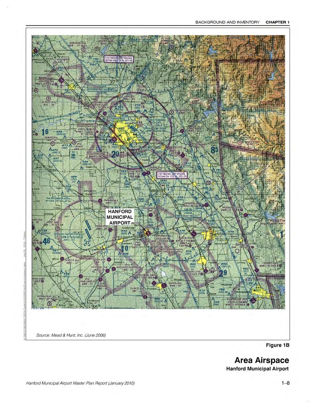
6 CHAPTER 1 BACKGROUND AND INVENTORY Management and Services Policy decisions concerning Hanford Municipal Airport are made by the Hanford City Council. Day-to-day operation and maintenance of the airport is under the auspices of Hanford Department of Public Works and airport manager. Services to pilots and aircraft are provided by a single major fixed base operation. The FBO offers Jet and 100LL fuel services via delivery truck and 24-hour card-lock system. Other services made available by the FBO are engine maintenance, flight training, parking for based and transient aircraft, air charter, and pilot supplies. AERONAUTICAL SETTING Area Airports Nearby airports interact with Hanford Municipal Airport in terms of both airspace, as described below, and shared service areas. There are 8 public-use and 12 private-use airports within a 28-mile radius of Hanford Municipal Airport. The greatest interaction is with Visalia Airport, located 11 nautical miles east of the airport. The nearest airline service airport is Fresno- Yosemite International, 28 nautical miles north. One other airport of significance to the local aeronautical setting is Lemoore Naval Air Station. See Table 1B for a listing of airports near Hanford Municipal Airport. Area Airspace Federal regulations define various categories of airspace with distinct operation requirements for each type. The airspace in the vicinity of Hanford Municipal Airport is relatively uncomplicated (Figure 1B). Class E airspace overlying the Hanford Municipal Airport begins at an elevation of 700 feet Mean Sea Level (MSL). Fresno Class C airspace starts about 25 nautical miles north of Hanford Municipal Airport. Lemoore Naval Air Station Class D airspace starts about 17 nautical miles west and has a ceiling of 2,700 feet MSL. Pilots transitioning through Class D airspace must establish radio contact with the operating control tower before they enter Class D controlled airspace. Victor Airway V-23 passes near Hanford Municipal Airport to the east. This airway provides a defined route that can be flown under instrument conditions. Airspace Classifications are illustrated in Figure 1C. 1-6 Hanford Municipal Airport Master Plan (Adopted January 2010)
7 BACKGROUND AND INVENTORY CHAPTER 1 Location Facilities Services Airport Name 1 Owner Associated City (County) Distance/Direction 2 Based Aircraft 3 Number of Runways Longest Runway (ft.) Surface 4 Lighting Intensity 5 Approach Visibility 6 Control Tower Airline Service AvGas Jet Fuel Maintenance Automobile Rentals Food Hanford Municipal City of Hanford Hanford (Kings) ,180 asph M 1 X X X Public Use Airport Corcoran Private (public use) Corcoran (Kings) 13 S ,800 asph L X X Fresno-Yosemite International City of Fresno Fresno (Fresno) 28 N ,217 asph H 1/2 X X X X X X X Fresno-Chandler Executive City of Fresno Fresno (Fresno) 27 N ,202 asph M 1 X X X Mefford City of Tulare Tulare (Tulare) 17 SE ,914 asph M X X X X Reedley Municipal City of Reedley Reedley (Fresno) 22 N ,300 asph M X X X X Selma Private (public use) Selma (Fresno) 16 N ,490 asph X X X Sequoia Field County of Tulare Visalia (Tulare) 17 NE ,012 asph X X Visalia City of Visalia Visalia (Tulare) 11 E ,559 asph H 1/2 X X X X X Military Airport Lemoore NAS/Reeves Field US Navy Lemoore (Kings) 17 W 2 13,502 conc H not open to public 1 Airports within 28 statute miles of Hanford Municipal Airport 2 Relative to Hanford Municipal Airport 3 FAA Airport Master Record data as of June 2004; totals exclude ultralights 4 ASPH=asphalt; CONC=concrete; GRAV=gravel 5 L=low; M=medium; H=high 6 Minimums for instrument approach procedures; distance in statute miles Table 1B Area Airports Hanford Airport Vicinity Hanford Municipal Airport Master Plan (Adopted January 2010) 1-7
8

9 BACKGROUND AND INVENTORY CHAPTER 1 Airspace Classes Communications Entry Requirements Separation A Required ATC clearance All N/A B Required ATC clearance All Yes C D Required Required Two-way communications prior to entry Two-way communications prior to entry E Not required for VFR None for VFR VFR/IFR Runway operations None for VFR Special VFR in Surface Area Yes Yes Yes G Not required None None N/A Figure 1C Airspace Classes Hanford Municipal Airport Hanford Municipal Airport Master Plan (Adopted January 2010) 1-9
 in support of Lemoore Naval Air Station")
10 CHAPTER 1 BACKGROUND AND INVENTORY The U.S. Navy and California Air National Guard have initiated a proposal to establish a Special Use Airspace which would consist of a Military Operations Area (MOA) in support of Lemoore Naval Air Station aircraft operations. An Environmental Assessment (EA) to evaluate the social, economic, and environmental effects of the proposed MOA began in October, As proposed, the MOA would be 30 nautical miles by 70 nautical miles. As this MOA could affect use of the Hanford Municipal Airport, it is evaluated in Chapter 3. COMMUNITY PROFILE The community served by Hanford Municipal Airport consists of Hanford and surrounding areas of Kings County. Historically, the economy of Kings County has centered on agriculture. Kings County is considered one of the most fertile regions in the world and is ranked twelfth in California by value of agriculture production. See Table 1C for additional information on the community served by Hanford Municipal Airport. Today, the economy has become more diversified. While agriculture is still a significant part of the County s economy, it is second to the government sector. Government represents the largest industry employer (35 percent) of the local economy, followed by agriculture (18 percent), trade, transportation, and utilities (12 percent). By 2006, the largest growth increase in Kings County is anticipated to take place in the service industry; 26.2 percent or 1,350 new service jobs. Between April 1, 2000 and July 1, 2003, the U.S. Census Bureau reported the population in the Kings County area increased by seven percent. Comparatively, over the same period, California encountered a 4.8 percent increase. By 2020, the California Department of Finance projects the population of Kings County to reach over 184,750. Hanford City Courthouse The U.S. Census combines statistical data for the cities of Hanford and Corcoran (e.g., Hanford-Corcoran Metropolitan Statistical Area-MSA). Between 1990 and 2000, the population in the Hanford-Corcoran MSA increased by 27.6 percent. The City of Hanford anticipates that this trend will continue, projecting the population to increase from its current 46,315 to more than 70,000 in the year Hanford Municipal Airport Master Plan (Adopted January 2010)
 and San Francisco-Sacramento area (north) City center 1-mile southeast of Hanford Municipal Airport Kings County seat Topography City of Hanford")
11 BACKGROUND AND INVENTORY CHAPTER 1 GEOGRAPHY Location City of Hanford: Incorporated August 8, square miles 200 miles from Los Angeles (south) and San Francisco-Sacramento area (north) City center 1-mile southeast of Hanford Municipal Airport Kings County seat Topography City of Hanford elevation: 249 feet Immediate vicinity of airport level, ranging generally between 245 feet and 250 feet above Mean Sea Level (MSL). SURFACE TRANSPORTATION Major Highways Three state highways serve the City of Hanford area: Hwy 198 (east-west) traverses through Hanford and Lemoore and intersects at Hwy 43 (north-south) at Hanford. Hwy 99 runs (north-south) is 15 miles east of Hanford Nearest interstate highway Interstate 5 is 30 miles to the west Railroads Santa Fe mainline and Southern Pacific Railroad secondary line Public Transportation Bus Service: Kings Area Rural Transit countywide service Orangebelt and Greyhound, both have connections to Greyhound network Train: Amtrak: five north and five south bound trains per day POPULATION AND ECONOMY Current/Historical Population Kings County 101, , , ,434 City of Hanford 30,463 36,482 41,686 46,315 City of Lemoore 13,622 15,417 19,712 21,916 Source: California Department of Finance Projected Population Kings County* 149, , ,751 City of Hanford 47,746 56,238 70,177 Source: California Department of Finance* Basis of Economy Economy historically based on agriculture Major employment by industry in Kings County (2002): Government 35% Agriculture 18% Trade, Transportation, Utilities 12% Manufacturing 9% Education, Health Services 8% Leisure, Hospitality 6% Other 12% (Source: California Economic Development Department) CLIMATE Temperature Avg. High Avg. Low Hottest month (July) 94.0 F 62.0 F Coldest month (January) 54.0 F 34.0 F Precipitation and Fog Average annual rainfall in Hanford: 7.95 inches Winds Prevailing winds from northwest Table 1C Community Profile Hanford Municipal Airport Master Plan (Adopted January 2010) 1 11
12 CHAPTER 1 BACKGROUND AND INVENTORY The City of Hanford is located within the Kings County Enterprise Zone (EZ). The purpose of the Enterprise Zone Program is to provide tax incentives to businesses and allow private sector market forces to stimulate the local economy. Special state and local incentives encourage business investment and promote the creation of new jobs. Businesses that operate within the EZ receive state tax credits, tax reductions for equipment purchases, and tax deductions for property acquired within the zone. Hanford is also located within the Recycling Market Development Zone. Businesses located inside the Recycling Market Development Zone qualify for low-interest loans to manufacture new products or that take on projects that reduce waste. PREVIOUS AIRPORT PLANS AND STUDIES Two comprehensive master plan studies have previously been prepared for Hanford Municipal Airport. The master plan studies were completed in 1978 (by Wilsey & Ham) and in 1993 (by P & D Aviation). Recommendations in the 1978 master plan included: a runway extension to the north, land acquisition for runway approach protection, surplus land be developed for industrial/commercial uses, and establishment of a hazard zoning ordinance. The primary focus of the 1993 master plan was to establish the appropriate Airport Reference Code (ARC) for the airport. The plan concluded the ARC to be B-II. That is, all future airport development (airfield and building areas) would comply with B-II design standards. Definition: Airport Reference Code (ARC). A coding system used to relate airport design criteria to the operational and physical characteristics of the airplanes intended to operate at an airport. Airfield improvements recommended under the 1993 plan included the southerly extension of Runway and acquisition of 95 acres of land. Future building development recommendations included 30 new hangar units, 50 or more shade hangars, parking for corporate aircraft, and expansion of the tiedown apron. Another important plan concerning Hanford Municipal Airport is the Kings County Comprehensive Land Use Plan adopted by the County Board of Supervisors in The purpose of the compatibility plan is to help prevent development of incompatible land uses around the airport. It does not contain recommendations regarding improvement or operation of the airport itself Hanford Municipal Airport Master Plan (Adopted January 2010)

13
Document prepared by MnDOT Office of Aeronautics and HNTB Corporation. MINNESOTA GO STATE AVIATION SYSTEM PLAN
 LAST UPDATE JULY 2013 Acknowledgements The preparation of this document was financed in part by a grant from the Federal Aviation Administration (Project No: 3-27-0000-07-10), with the financial support
1.1.3 Taxiways. Figure 1-15: Taxiway Data. DRAFT Inventory TYPICAL PAVEMENT CROSS-SECTION LIGHTING TYPE LENGTH (FEET) WIDTH (FEET) LIGHTING CONDITION
 WIDTH (FEET) LIGHTING CONDITION") 1.1.3 Taxiways EWN has an extensive network of taxiways and taxilanes connecting the terminal, air cargo, and general aviation areas with the runways as listed in Figure 1-15. A 50-foot wide parallel taxiway
1.1.3 Taxiways EWN has an extensive network of taxiways and taxilanes connecting the terminal, air cargo, and general aviation areas with the runways as listed in Figure 1-15. A 50-foot wide parallel taxiway
Background and Inventory
 1 Background and Inventory HEMET-RYAN AIRPORT Locations and Environs Hemet-Ryan Airport is situated in the San Jacinto Valley at the foot of the San Jacinto Mountains in Riverside County, California. The
Aviation Planning in Maine and Our Region. Stacie Haskell Aviation Coordinator & Study Manager Maine Department of Transportation April 27, 2011
 Aviation Planning in Maine and Our Region Stacie Haskell Aviation Coordinator & Study Manager Maine Department of Transportation April 27, 2011 Overview The National Aviation System Maine s Economic Dependence
Source: Chippewa Valley Regional Airport ASOS, Period of Record
 Chapter 1 Inventory Runway wind coverage is the percentage of time a runway can be used without exceeding allowable crosswind velocities. Allowable crosswind velocities vary depending on aircraft size
Chapter 4 Airport Facility Requirements
 Chapter 4 Airport Facility Requirements Introduction CHAPTER 4 AIRPORT FACILITY REQUIREMENTS MAY 2013-1 Organization of Materials CHAPTER 4 AIRPORT FACILITY REQUIREMENTS MAY 2013-2 RPZ - ROAD RPZ - NON-AIRPORT
CHAPTER 1 BACKGROUND AND PROPOSED ACTION
 CHAPTER 1 BACKGROUND AND PROPOSED ACTION 1.0 INTRODUCTION An Environmental Assessment (EA) evaluates the effects of a proposed Federal action on the surrounding environment and is prepared in compliance
Milton. PeterPrinceAirportislocatedinSantaRosaCounty, approximatelythreemileseastofmilton.
 Milton GeneralAviationAirport PeterPrinceAirportislocatedinSantaRosaCounty, approximatelythreemileseastofmilton. Existing Facilities Peter Prince Airport is served by one runway, Runway 18/36, 3,700 feet
Chapter One INVENTORY
 Chapter One INVENTORY Airport Layout Plan Report The initial step in the preparation of the Airport Layout Plan Report for is the collection of information pertaining to the Airport and the area it serves.
CHAPTER 1 INTRODUCTION AND BACKGROUND
 CHAPTER 1 INTRODUCTION AND BACKGROUND An Environmental Assessment (EA) evaluates the effects of a proposed Federal action on the surrounding environment and is prepared in compliance with the National
Chapter 9 - AIRPORT SYSTEM DESIGN
 Chapter 9 - AIRPORT SYSTEM DESIGN 9.01 GENERAL This chapter discusses the development program for Dutchess County Airport to the year 2020. This airport system design is based upon the airport's existing
BELFAST MUNICIPAL AIRPORT OVERVIEW
 BELFAST MUNICIPAL AIRPORT OVERVIEW LOCATION AND HISTORY Belfast Municipal Airport (Federal Aviation Administration (FAA) airport code BST, International Civil Aviation Organization airport code KBST, FAA
OVERVIEW BASIC DESIGN FACTORS. Demand Determinants
 3 Airfield Airfield Design Design OVERVIEW The basic configuration of the runway and taxiway system at Hanford Municipal Airport has changed moderately since the airport was constructed in 1950. These
The purpose of this Demand/Capacity. The airfield configuration for SPG. Methods for determining airport AIRPORT DEMAND CAPACITY. Runway Configuration
 Chapter 4 Page 65 AIRPORT DEMAND CAPACITY The purpose of this Demand/Capacity Analysis is to examine the capability of the Albert Whitted Airport (SPG) to meet the needs of its users. In doing so, this
Airport Master Plan. Brookings Regional Airport. Runway Runway 17-35
 Runway 17-35 Airport Master Plan Runway 12-30 Brookings Regional Airport Table of Contents Table of Contents Chapter 1: Master Plan Goals... 1-1 1.1. Introduction... 1 1.2. Objective 1 Identify improvements
BUSINESS OF THE CITY COUNCIL CITY OF MERCER ISLAND, WA
 BUSINESS OF THE CITY COUNCIL CITY OF MERCER ISLAND, WA AB 4564 September 7, 2010 Regular Business RENTON AIRPORT STATUS UPDATE Proposed Council Action: Receive update. No action required. DEPARTMENT OF
COMMERCIAL AND GENERAL AVIATION
 Existing Facilities Daytona Beach International Airport is served by a number of airside and landside facilities. The airport has three asphalt runways: Runway 07L/25R (10,500 feet long by 150 feet wide),
Inventory of Existing Conditions.
 A Inventory of Existing Conditions. Fort Collins-Loveland Municipal Airport, jointly owned and operated by the Cities of Fort Collins and Loveland, is located in the heart of a region with a thriving economy,
Agenda: SASP SAC Meeting 3
 Agenda: SASP SAC Meeting 3 Date: 04/12/18 Public Involvement Plan Update Defining the System Recommended Classifications Discussion Break Review current system Outreach what we heard Proposed changes Classification
Public Review Draft South County Airport Master Plan Report. County of Santa Clara San Martin, California
 Public Review Draft South County Airport Master Plan Report County of Santa Clara San Martin, California July 2005 County of Santa Clara Board of Supervisors Donald F. Gage Blanca Alvarado Peter A. McHugh
The following criteria shall be applied within the boundaries of the AO District:
 Sec. 419 (a) Purpose AIRPORT OVERLAY DISTRICT (AO) The purpose of the Airport Overlay District is to regulate and restrict the height of structures, objects, or natural growth, regulate the locations of
SITE ELEVATION AMSL...Ground Elevation in feet AMSL STRUCTURE HEIGHT...Height Above Ground Level OVERALL HEIGHT AMSL...Total Overall Height AMSL
 ******************************************** * Federal Airways & Airspace * * Summary Report * ******************************************** File: User Assigned File Name Latitude: NAD83 Coordinate Longitude:
DRAFT FINAL REPORT AIRPORT MASTER PLAN. Rifle Garfield County Airport Revised May 15, 2014
 DRAFT FINAL REPORT AIRPORT MASTER PLAN Rifle Garfield County Airport Revised May 15, 2014 As required by Paragraph 425.B(4) of FAA Order 5100.38C, Airport Improvement Program (AIP) Handbook: The preparation
Chapter 9 - Airspace: The Wild Blue, Green & Red Yonder
 I5 Class G Airspace 38. [I4/3/3] What minimum visibility and clearance from clouds are required for VFR operations in Class G airspace at 700 feet AGL or lower during daylight hours? A. mile visibility
1.0 Project Background Mission Statement and Goals Objectives of this Sustainable Master Plan
 TABLE OF CONTENTS CHAPTER 1 INTRODUCTION 10 Project Background 1-1 11 Mission Statement and Goals 1-1 12 Objectives of this Sustainable Master Plan 1-2 CHAPTER 2 INVENTORY 20 Airport Background 2-1 201
Acronyms. Airport Layout Plan Report Appendix A A-1
 Appendix A Acronyms AC... Advisory Circular ADG... Airplane Design Group ADO... Airport District Office AGL... Above Ground Level AIM... Aeronautical Information Manual AIP... Airport Improvement Program
PLAN Anoka County - Blaine Airport
 Reliever Airports: NOISE ABATEMENT PLAN Anoka County - Blaine Airport INTRODUCTION The noise abatement plan for the Anoka County-Blaine Airport was prepared in recognition of the need to make the airport
Current Airport Roles
 Chapter Four: Current Airport Roles Introduction Current airport roles are defined differently from national, state, and local perspectives. The Federal Aviation Administration (FAA) has established two
Prepared By: Mead & Hunt, Inc Port Lansing Road Lansing, MI 48906
 Master Plan The preparation of this document was financed in part through a planning grant from the Federal Aviation Administration (FAA) as provided under Section 505 of the Airport and Airway Improvement
Chapter Six ALP Drawings. Tacoma Narrows Airport. Master Plan Update
 Chapter Six ALP Drawings Master Plan Update The master planning process for the (Airport) has evolved through efforts in the previous chapters to analyze future aviation demand, establish airside and landside
CHAPTER 3 AIRPORT FACILITY REQUIREMENTS
 CHAPTER 3 AIRPORT FACILITY REQUIREMENTS 3.1 Introduction The existing runway and taxiway system at Skyhaven Airport provides more than adequate operational capacity to accommodate future peak hour and
South County Airport Master Plan Report. County of Santa Clara San Martin, California
 South County Airport Master Plan Report County of Santa Clara San Martin, California July 2006 County of Santa Clara Board of Supervisors Donald F. Gage Blanca Alvarado Peter A. McHugh James T. Beall,
Flying Cloud Airport (FCM) Zoning Process: Informing a Mn/DOT Path Forward
 Zoning Process: Informing a Mn/DOT Path Forward") : Informing a Mn/DOT Path Forward A Review of the Flying Cloud Airport (FCM) Joint Airport Zoning Board (JAZB) Process and the Draft Airport Zoning Ordinance B A RPZ RPZ A B C Zone Chad E. Leqve Director
: Informing a Mn/DOT Path Forward A Review of the Flying Cloud Airport (FCM) Joint Airport Zoning Board (JAZB) Process and the Draft Airport Zoning Ordinance B A RPZ RPZ A B C Zone Chad E. Leqve Director
FACILITY REQUIREMENTS SUMMARY OF KEY ISSUES OVERVIEW
 FACILITY REQUIREMENTS SUMMARY OF KEY ISSUES OVERVIEW This summary is intended to provide a brief overview of the key issues associated with conformance to FAA standards at Methow Valley State Airport.
ArcadiaMunicipalAirportislocatedonthesoutheast sideofarcadia,southofstateroute70,westofstate Route31,andisaccessiblefrom AirportRoad.
 Arcadia GeneralAviationAirport ArcadiaMunicipalAirportislocatedonthesoutheast sideofarcadia,southofstateroute70,westofstate Route31,andisaccessiblefrom AirportRoad.Arcadia islocatedapproximately30milesnortheastoftheport
CHAPTER 1 EXECUTIVE SUMMARY
 CHAPTER 1 EXECUTIVE SUMMARY 1 1 EXECUTIVE SUMMARY INTRODUCTION William R. Fairchild International Airport (CLM) is located approximately three miles west of the city of Port Angeles, Washington. The airport
The Future of Aviation for Central New Mexico
 The Future of Aviation for Central New Mexico MISSION STATEMENT THE WHOLE AIRPORT EXPERIENCE HISTORY SPECIFICATIONS FACILITIES SERVICES RECENT IMPROVEMENTS FUTURE DEVELOPMENT & USE USER PROFILE The mission
Background Data: Lincoln Regional Airport and Environs
 6 Background Data: and Environs INTRODUCTION /Karl Harder Field is a former military training airfield built during World War II on a mile-square section of open rangeland some three miles west of central
Merritt Island Airport
 TABLE OF CONTENTS CHAPTER 1 INTRODUCTION... 1-1 INTRODUCTION AND PROJECT OVERVIEW... 1-1 General Guidelines... 1-1 Prior Planning Documentation... 1-2 Key Issues... 1-2 Goals and Objectives... 1-2 Regulatory
Airfield Design OVERVIEW BASIC DESIGN FACTORS. Airport Role
 3 Airfield Design OVERVIEW Due to the presence of significant physical constraints, little change to the existing airfield is anticipated. The emphasis in this plan is on identifying airfield improvements
Bremerton National Airport Airport Master Plan Project Update February 12, 2013
 Bremerton National Airport Airport Master Plan Project Update February 12, 2013 Project Team Century West Engineering Northwest firm founded in 1969 500+ airport projects completed throughout the Pacific
Kittitas County Airport Bowers Field Airport Master Plan Planning Advisory Committee Meeting #1 April 6, 2016
 Kittitas County Airport Bowers Field Airport Master Plan Planning Advisory Committee Meeting #1 April 6, 2016 Project Team Kittitas County, WA Airport Owner (Sponsor) and Operator, Land Use Century West
Table of Contents. Overview Objectives Key Issues Process...1-3
 Table of Contents Chapter One Introduction Overview...1-1 Objectives...1-1 Key Issues...1-2 Process...1-3 Chapter Two Inventory of Existing Conditions Airport Setting...2-1 Locale...2-1 Airport Surroundings...2-5
OREGON AVIATION PLAN AIRPORT SUMMARY CORVALLIS MUNICIPAL AIRPORT
 OREGON AVIATION PLAN AIRPORT SUMMARY CORVALLIS MUNICIPAL AIRPORT In 2018, the Oregon Department of Aviation (ODA) updated the Oregon Aviation Plan (OAP) for the state airport system which includes 95 airports,
Reliever Airports: NOISE ABATEMENT PLAN Flying Cloud Airport (FCM)
") Reliever Airports: NOISE ABATEMENT PLAN Flying Cloud Airport (FCM) INTRODUCTION The Noise Abatement Plan (FCM Plan) for the Flying Cloud Airport has been prepared in recognition of the need to make the
Reliever Airports: NOISE ABATEMENT PLAN Flying Cloud Airport (FCM) INTRODUCTION The Noise Abatement Plan (FCM Plan) for the Flying Cloud Airport has been prepared in recognition of the need to make the
OREGON AVIATION PLAN AIRPORT SUMMARY CRATER LAKE-KLAMATH REGIONAL AIRPORT
 OREGON AVIATION PLAN AIRPORT SUMMARY CRATER LAKE-KLAMATH REGIONAL AIRPORT In 2018, the Oregon Department of Aviation (ODA) updated the Oregon Aviation Plan (OAP) for the state airport system which includes
DEPARTMENT: CIVIL ENGINEERING SEMESTER: III SUBJECT CODE / Name: CE2303/ Railway, Airport and Harbors Engineering 2 MARK QUESTIONS AND ANSWERS
 DEPARTMENT: CIVIL ENGINEERING SEMESTER: III SUBJECT CODE / Name: CE2303/ Railway, Airport and Harbors Engineering 2 MARK QUESTIONS AND ANSWERS 1.Define wind Coverage (AUC NOV/DEC 2010),(AUC NOV/DEC 2011)
Executive Summary. MASTER PLAN UPDATE Fort Collins-Loveland Municipal Airport
 Executive Summary MASTER PLAN UPDATE Fort Collins-Loveland Municipal Airport As a general aviation and commercial service airport, Fort Collins- Loveland Municipal Airport serves as an important niche
Draft Palo Alto Airport Master Plan Report County of Santa Clara, California October 2005
 Draft Palo Alto Airport Master Plan Report County of Santa Clara, California October 2005 County of Santa Clara Board of Supervisors Donald F. Gage Blanca Alvarado Peter A. McHugh James T. Beall, Jr. Liz
Tallahassee International Airport Master Plan. Technical Advisory Committee Meeting #2 October 19, 2016
 Tallahassee International Airport Master Plan Technical Advisory Committee Meeting #2 October 19, 2016 Agenda Welcome / Introductions Master Plan Process and Project Status Forecast of Aviation Demand
STUDY WORK GROUP MEETING No. 3. November 29, 2016
 STUDY WORK GROUP MEETING No. 3 November 29, 2016 Agenda Welcome and introductions Update project schedule Brief overview of previous SWG meeting Update on aviation forecasts Introduction to airfield demand/capacity
Chapter 2: Existing Facilities
 Chapter 2: Existing Facilities This chapter describes the existing conditions at the airport and provides an inventory of existing facilities and infrastructure. It provides the baseline for future requirements,
Appendix D Project Newsletters. Tacoma Narrows Airport. Master Plan Update
 Appendix D Project Newsletters Tacoma Narrows Airport Master Plan Update This appendix contains the newsletters distributed throughout the project. These newsletters provided updates and information on
Airport Master Plan for. Brown Field Municipal Airport PAC Meeting #3
 Airport Master Plan for Brown Field Municipal Airport PAC Meeting #3 Public Meeting #1 > 8/24/17 from 5:30 to 8:00 pm > 41 attendees signed-in > Comments: > EAA area > Environmental constraints > Focus
Background Data: Blue Canyon Airport and Environs
 5 Background Data: and Environs INTRODUCTION serves as an important emergency landing field amid mountainous terrain. The airport has existed on the site since the 1930s or 40s. The facility was operated
NAVIGATION: CHARTS, PUBLICATIONS, FLIGHT COMPUTERS (chapters 7 & 8)
") NAVIGATION: CHARTS, PUBLICATIONS, FLIGHT COMPUTERS (chapters 7 & 8) LONGITUDE AND LATITUDE 1. The location of an airport can be determined by the intersection of lines of latitude and longitude. a. Lines
NAVIGATION: CHARTS, PUBLICATIONS, FLIGHT COMPUTERS (chapters 7 & 8) LONGITUDE AND LATITUDE 1. The location of an airport can be determined by the intersection of lines of latitude and longitude. a. Lines
Lopez Island Airport Master Plan Update. Public Meeting June 15, 2017
 Lopez Island Airport Master Plan Update Public Meeting June 15, 2017 Master Plan Update Team Reid Middleton/Everett, WA Shannon Kinsella, Project Manager Melania Haagsma, Project Engineer Mead & Hunt/Tulsa,
APPENDIX D FEDERAL AVIATION REGULATIONS, PART 77
 APPENDIX D FEDERAL AVIATION REGULATIONS, PART 77 Subparts A through C PART 77 - OBJECTS AFFECTING NAVIGABLE AIRSPACE Subpart A General 77.1 Scope. 77.2 Definition of terms. 77.3 Standards. 77.5 Kinds of
STAFF REPORT. Airport Land Use Consistency Determination Betteravia Plaza. MEETING DATE: January 21, 2016 AGENDA ITEM: 8D
 STAFF REPORT SUBJECT: Airport Land Use Consistency Determination Betteravia Plaza MEETING DATE: AGENDA ITEM: 8D STAFF CONTACT: Andrew Orfila RECOMMENDATION: Adopt findings for the Betteravia Plaza project
TABLE OF CONTENTS. General Study Objectives Public Involvement Issues to Be Resolved
 TABLE OF CONTENTS Description Page Number LIST OF ACRONYMS... a CHAPTER ONE INTRODUCTION General... 1-1 Study Objectives... 1-1 Public Involvement... 1-2 Issues to Be Resolved... 1-2 CHAPTER TWO EXISTING
Aviation, Rail, & Trucking 6-1
 6-1 This chapter describes the services, facilities, and condition of air, rail, and trucking as components of the transportation system. These three intermodal areas have an impact on the factors to be
New Opportunities PUBLIC WORKSHOP. Venice Municipal. Bringing g the pieces together
 Bringing g the PUBLIC WORKSHOP Venice Municipal Airport New Opportunities Presented for Venice City Council & Citizens of Venice September 25, 2009 Slide 1 Bringing g the Welcome & Introductions May 12th
CATCODE ] CATCODE
![CATCODE ] CATCODE](/thumbs/82/85644630.jpg "CATCODE ] CATCODE") Runways. FAC: 1111 CATCODE: 111111 OPR: AFCEC/COS OCR: AF/A3O-A 1.1. Description. The runway is the paved surface provided for normal aircraft landings and take offs. Runways are classified as either Class
Runways. FAC: 1111 CATCODE: 111111 OPR: AFCEC/COS OCR: AF/A3O-A 1.1. Description. The runway is the paved surface provided for normal aircraft landings and take offs. Runways are classified as either Class
CHAPTER 3 ALTERNATIVES CONSIDERED
 CHAPTER 3 ALTERNATIVES CONSIDERED 3.0 ALTERNATIVES The 2010 Stevensville Airport Master Plan contained five (5) airside development options designed to meet projected demands. Each of the options from
Updates to Procedures at St. John s International Airport
 October 10, 2017 Updates to Procedures at St. John s International Airport This document provides notice of upcoming changes to instrument procedures being implemented by NAV CANADA at the St. John s International
DRAFT MASTER PLAN UPDATE
 DRAFT MASTER PLAN UPDATE CHAPTER VI: AIRPORT LAYOUT PLAN NARRATIVE DRAFT REPORT APRIL 2017 PREPARED BY: Table of Contents WESTCHESTER COUNTY AIRPORT 6 AIRPORT LAYOUT PLAN NARRATIVE REPORT... 6-1 6.1 AGIS
Airport Master Plan Update
 Duttchessss Countty Airrporrtt Masstterr Plan Updatte Airport Master Plan Update Final Report Dutchess County Airport Town of Wappingers, New York C&S Engineers, Inc. 499 Col. Eileen Collins Blvd. Syracuse,
a. Aeronautical charts DID THIS IN LESSON 2
 AIRMAN CERTIFICATION STANDARDS: REMOTE PILOT SMALL: You will know and be able to explain in writing or oral form the below tasks regarding AIRPORT OPERATIONS Task References Objective Task B. Airport Operations
Why are the underground fuel tanks being removed and replaced with above ground tanks?
 AIRPORT/CITIZEN FAQ This list of Frequently Asked Questions (FAQs) with responses are provided to share information related to airport topics with the Citizens of Georgetown. The questions / responses
Airport Master Plan. Rapid City Regional Airport. October 2015 FAA Submittal
 Airport Master Plan Rapid City Regional Airport October 2015 FAA Submittal Rapid City Regional Airport Master Plan Update Table of Contents Executive Summary... i Scope & Timeline... i Forecasts... i Preferred
STAFF REPORT. Airport Land Use Plan Consistency Review: Santa Barbara Airport Master Plan. MEETING DATE: November 19, 2015 AGENDA ITEM: 7D
 STAFF REPORT SUBJECT: Airport Land Use Plan Consistency Review: Santa Barbara Airport Master Plan MEETING DATE: AGENDA ITEM: 7D STAFF CONTACT: Peter Imhof, Andrew Orfila RECOMMENDATION: Adopt findings
Notice of Extended Comment Period for an Intent to Adopt a Negative Declaration
 County of Santa Clara Department of Planning and Development Planning Office County Government Center, East Wing, 7 th Floor 70 West Hedding Street San Jose, California 95110-1705 (408) 299-5770 FAX (408)
Basic Design Factors. Airfield Design. Airport Role
 Chapter 3 Airfield Design Basic Design Factors The Federal Aviation Administration (FAA) provides guidance and standards for airport design through a series of Advisory Circulars (ACs). These guidelines
6.1 INTRODUCTION 6.2 AIRSIDE ALTERNATIVES NORTH PERRY AIRPORT MASTER PLAN UPDATE RUNWAY LENGTH REQUIREMENTS SECTION 6: ALTERNATIVES ANALYSIS
 6.1 INTRODUCTION In the previous chapter, facility needs for the 20-year planning horizon were identified. The next step in the planning process is to identify and evaluate the various ways certain facilities
SOPs for Cedar Valley Airport UT10
 SOPs for Cedar Valley Airport UT10 Cedar Valley Airport is a privately owned airport located approximately 10 miles west of Lehi, Ut and 5 miles northeast of Cedar Fort, UT. The airport location is N40.3572
105 SKY KING TAXI-WAY - SPICEWOOD, TEXAS
 S P I C E W O O D A I R P O R T 8 8 R H A N G A R F O R L E A S E 105 SKY KING TAXI-WAY - SPICEWOOD, TEXAS Available for immediate lease 7,200 SF (90 x 80 ) Class A Aircraft Hangar W / Climate Controlled
TABLE OF CONTENTS. Washington Aviation System Plan Update July 2017 i
 TABLE OF CONTENTS Chapter 1 Overview... 1-1 1.1 Background... 1-1 1.2 Overview of 2015 WASP... 1-1 1.2.1 Aviation System Performance... 1-2 1.3 Prior WSDOT Aviation Planning Studies... 1-3 1.3.1 2009 Long-Term
Hartford-Brainard Airport Potential Runway Closure White Paper
 Hartford-Brainard Airport Potential Runway 11-29 Closure White Paper June 2012 In recent years there has been discussion regarding the necessity of Runway 11-29 to the Hartford- Brainard Airport (HFD)
Chapter The All-new, World-class Denver International Airport Identify Describe Know Describe Describe
 Chapter 10 The aerospace subject is very large and diverse. As seen in previous chapters, there are many subject areas. So far you have learned about history, weather, space and aerodynamics. Now you will
APPENDIX D MSP Airfield Simulation Analysis
 APPENDIX D MSP Airfield Simulation Analysis This page is left intentionally blank. MSP Airfield Simulation Analysis Technical Report Prepared by: HNTB November 2011 2020 Improvements Environmental Assessment/
ERIE INTERNATIONAL AIRPORT MASTER PLAN TABLE OF CONTENTS
 EXECUTIVE SUMMARY ERIE INTERNATIONAL AIRPORT MASTER PLAN TABLE OF CONTENTS PAGE NO. CHAPTER 1-INTRODUCTION... 1-1 1.01 General...1-1 1.02 Purpose and Scope of Study...1-1 1.03 The Planning Process...1-2
SouthwestFloridaInternational Airport
 SouthwestFloridaInternational Airport SouthwestFloridaInternationalAirportislocatedinLee CountyalongtheGulfCoastofSouthFlorida,tenmiles southeastofthefortmyerscentralbusinessdistrict. Theprimaryhighwayaccesstotheairportfrom
Introduction and Background. Introduction. Chapter 1
 Chapter 1 Introduction and Background Introduction The Pullman-Moscow Regional Airport (PMRA) is undertaking a master plan study which, when completed, will ultimately define the airport s future role
Addendum - Airport Development Alternatives (Chapter 6)
") Bowers Field Addendum - Airport Development Alternatives (Chapter 6) This addendum to the Airport Development Alternatives chapter includes the preferred airside development alternative and the preliminary
Bowers Field Addendum - Airport Development Alternatives (Chapter 6) This addendum to the Airport Development Alternatives chapter includes the preferred airside development alternative and the preliminary
Chapter 4 Development Alternatives
 LAKE COUNTY AIRPORT MASTER PLAN UPDATE The preceding chapter identified deficiencies of the Lake County Airport (Airport) with respect to existing and anticipated aeronautical demand, which are consistent
Background and Inventory
 1 Background and Inventory JACQUELINE COCHRAN REGIONAL AIRPORT Airport History In 1942, the U. S. Government developed the Thermal Airport for military aviation training purposes during World War II. The
Airport Master Plan for Montgomery-Gibbs Executive Airport PAC Meeting #3
 Airport Master Plan for Montgomery-Gibbs Executive Airport PAC Meeting #3 Agenda > Introductions > Public Meetings Overview > Working Paper 3 - Facility Requirements > Working Paper 4 - Environmental Baseline
DO NOT BEGIN THIS WORK UNTIL YOU HAVE COMPLETED ALL REQUIRED ASSIGNED READING AND EXERCISES.
 DO NOT BEGIN THIS WORK UNTIL YOU HAVE COMPLETED ALL REQUIRED ASSIGNED READING AND EXERCISES. Gardner Textbook Review Questions to prepare for Class #12 Answer these on notebook paper (or a text file) then
COMMERCIAL AND GENERAL AVIATION Historic and forecast FDOT aviation activity information on file for Pensacola Regional Airport:
 Existing Facilities Pensacola Regional Airport is served by a number of airside and landside facilities. Two intersecting, grooved asphalt runways serve the airport. These runways are runway 17/35 (7,004
Safety, Infrastructure, and Tenant Improvement Project. Public Hearing Informational Brochure February 26, 2013
 New York State Department of Transportation Safety, Infrastructure, and Tenant Improvement Project Public Hearing Informational Brochure February 26, 2013 This DEIS/Draft EA evaluates the potential impacts
APPENDIX F AIRSPACE INFORMATION
 APPENDIX F AIRSPACE INFORMATION Airspace Use DEFINITION OF AIRSPACE Airspace, or that space which lies above a nation and comes under its jurisdiction, is generally viewed as being unlimited. However,
Appendix K: MSP Class B Airspace
 Appendix K: MSP Class B Airspace K All of the open sky covering the United States, from less than an inch off the ground all the way to outer space, is part of America s airspace. This airspace resource
General Aviation Master Plan Update
 Peter O. Knight Airport Public Meeting #2 Peter O. Knight Airport Agenda Welcome and Introductions HCAA System of Airports Purpose of Public Meetings Master Plan Status Update Next Steps Q & A 2 Our System
at: Accessed May 4, 2011.
 3.11 SAFETY 3.11.1 Background and Methodology As with other forms of transportation, there is risk associated with aviation activities. This section focuses on risk to those on the ground near airports.
Airport Layout Plan Narrative Report
 Airport Layout Plan Narrative Report Yuba County Airport Olivehurst, California Prepared for County of Yuba Prepared by Mead & Hunt, Inc. March 23, 2017 YUBA COUNTY AIRPORT AIRPORT LAYOUT PLAN NARRATIVE
2009 Muskoka Airport Economic Impact Study
 2009 Muskoka Airport Economic Impact Study November 4, 2009 Prepared by The District of Muskoka Planning and Economic Development Department BACKGROUND The Muskoka Airport is situated at the north end
Effective Altitude. R-3103 To 30,000 (To 9,144 meters) Source: NACO 2002 Notes: 1 By NOTAM issued 12 hours in advance
 Source: NACO 2002 Notes: 1 By NOTAM issued 12 hours in advance") 8.4 AIRSPACE USE 8.4.1 Affected Environment The affected airspace environment is described below in terms of its principal attributes, namely controlled and uncontrolled airspace, special use airspace,
8.4 AIRSPACE USE 8.4.1 Affected Environment The affected airspace environment is described below in terms of its principal attributes, namely controlled and uncontrolled airspace, special use airspace,
Grants Pass Airport Master Plan & Airport Layout Plan Update
 Attendees: Grants Pass Airport Master Plan & Airport Layout Plan Update Meeting #3 January 26, 2010 Merlin Community Center 100 Acorn Street, Merlin 5:45 7:15 p.m. Josephine County Department of Airports:
Chapter 6. Nonradar. Section 1. General DISTANCE
 12/10/15 JO 7110.65W Chapter 6. Nonradar Section 1. General 6 1 1. DISTANCE Use mileage based (DME and/or ATD) procedures and minima only when direct pilot/controller communications are maintained. FIG
Chapter Seven COST ESTIMATES AND FUNDING A. GENERAL
 Chapter Seven COST ESTIMATES AND FUNDING A. GENERAL This chapter delineates the recommended 2005 2024 Sussex County Airport Capital Improvement Program (CIP). It further identifies probable construction